
Flowery Branch City Zoning Code
ARTICLE 27
- CONSERVATION SUBDIVISIONS
Sec. 27.1.- Purpose and Intent.
This Article is adopted with the following purposes and intentions:
(a)
To provide for the preservation of greenspace as a nonstructural stormwater runoff and watershed protection measure.
(b)
To provide residential zoning districts that permit flexibility of design in order to promote environmentally sensitive and efficient uses of the land.
(c)
To preserve in perpetuity unique or sensitive natural resources such as groundwater recharge areas, floodplains, wetlands, streams, steep slopes, woodlands and wildlife habitat.
(d)
To permit clustering of houses and structures on less environmentally sensitive soils which will reduce the amount of infrastructure, including paved surfaces and utility easements, necessary for residential development.
(e)
To reduce erosion and sedimentation by minimizing land disturbance and removal of vegetation in residential development.
(f)
To promote interconnected greenways and corridors throughout the community.
(g)
To promote contiguous greenspace with adjacent jurisdictions.
(h)
To encourage interaction in the community by clustering houses and orienting them closer to the street, providing public gathering places and encouraging use of parks and community facilities as focal points in the neighborhood.
(i)
To encourage street designs that reduce traffic speeds and reliance on main arteries.
(j)
To promote construction of convenient landscaped walking trails and bike paths both within the subdivision and connected to neighboring communities, businesses, and facilities to reduce reliance on automobiles.
(k)
To conserve scenic views and reduce perceived density by maximizing the number of houses with direct access to and views of open space.
(l)
To preserve important historic and archaeological sites.
Sec. 27.2. - Applicability of Regulations.
This Article on Conservation Subdivisions is an option available in the Conventional Residential Zoning Districts established in Article 6 of this zoning ordinance. The applicant shall comply with all other provisions of the zoning ordinance and all other applicable laws, except those provisions specifically allowed otherwise in this Article.
Sec. 27.3. - Definitions.
Active recreation: Equipment and areas prepared for active use for recreational and leisure purposes, including but not limited to: playground equipment (swing sets and climbing structures); courts for basketball, volleyball, and tennis; leveled, striped fields for football, soccer, or multiple purposes; community picnic pavilions (including covered facilities with grills and/or fire rings); community buildings for recreational events, and golf courses, including clubhouses, developed areas and accessory uses. Trails and bikeways through open spaces shall not be considered active recreational facilities.
Conservation easement: A nonpossessory interest of a holder in real property imposing limitations or affirmative obligations, the purposes of which include retaining or protecting natural, scenic, or open-space values of real property; assuring its availability for agricultural, forest, recreational, or open-space use; protecting natural resources; maintaining or enhancing air or water quality; or preserving the historical, architectural, archeological, or cultural aspects of real property (O.C.G.A. § 44-10-1); A legally enforceable agreement between a property owner and the holder of the easement, in a form acceptable to the Governing Body and recorded in the office of the Clerk of Superior Court of Hall County. A conservation easement restricts the existing and future use of the defined tract or lot to conservation use, agriculture, passive recreation, or other specifically permitted use and prohibits further subdivision or development.
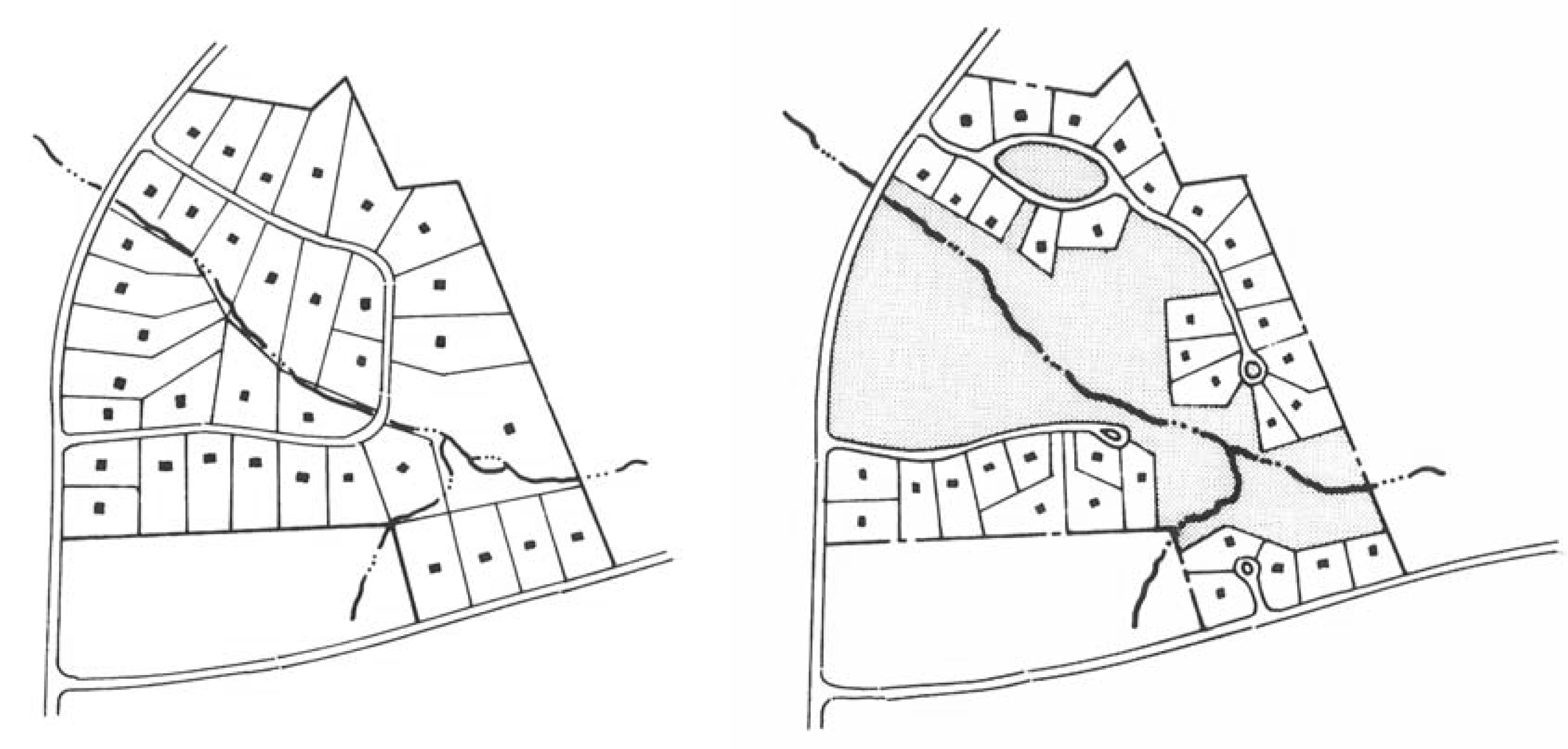
Conservation subdivision: A subdivision for detached, single-family, fee simple residences where open space is the central organizing element of the subdivision design and that identifies and permanently protects all primary and all or some of the secondary conservation areas within the boundaries of the subdivision. A conservation subdivision is not a use per se, but rather, a land planning technique that allows the clustering of uses in order to protect open spaces.
_____
Source: Arendt, Randall G. 1996. Conservation Design for Subdivisions: A Practical Guide to Creating Open Space Networks. Washington, DC: Island Press. p. 128.
_____
Land trust: A private, nonprofit conservation organization formed to protect natural resources, such as productive farm or forest land, natural areas, historic structures, and recreational areas. Land trusts purchase and accept donations of conservation easements. They educate the public about the need to conserve land and some provide land-use and estate planning services to local governments and individual citizens.
Open space: The portion of the conservation subdivision that has been set aside for permanent protection. Activities within the open space are restricted in perpetuity through the use of an approved legal instrument.
Passive recreation: Recreational activities and places that generally do not require a developed site. This generally includes such activities as hiking, horseback riding, and picnicking, provided that such activities occur in a manner that is consistent with existing natural conditions.
Primary conservation areas: Areas within a conservation subdivision set aside for permanent protection, including the following:
(a)
Slopes over 25 percent of at least 5,000 square feet contiguous area;
(b)
The 100-year floodplain;
(c)
Buffer zones of at least 75 feet in width along all perennial and intermittent streams;
(d)
Wetlands that meet the definition used by the U.S. Army Corps of Engineers pursuant to the Clean Water Act;
(e)
Populations of endangered or threatened species, or habitat for such species; and,
(f)
Archaeological sites, cemeteries and burial grounds.
Source: Arendt, Randall G. 1996. Conservation Design for Subdivisions: A Practical Guide to Creating Open Space Networks. Washington, DC: Island Press. pp. 72.
Secondary conservation areas: Areas within a conservation subdivision that should be included within the Open Space to the maximum extent feasible, including the following:
(a)
Important historic sites;
(b)
Existing healthy, native forests of at least one acre contiguous area;
(c)
Individual existing healthy trees greater than 8 inches caliper, as measured from their outermost drip line;
(d)
Other significant natural features and scenic viewsheds such as ridge lines, peaks and rock outcroppings, particularly those that can be seen from public roads;
(e)
Prime agricultural lands of at least five acres contiguous area; and,
(f)
Existing trails that connect the conservation subdivision to neighboring areas.
Source: Arendt, Randall G. 1996. Conservation Design for Subdivisions: A Practical Guide to Creating Open Space Networks. Washington, DC: Island Press. pp. 72.
Sec. 27.4. - Ownership of Development Site.
The tract of land to be subdivided pursuant to this Article may be held in single and separate ownership or in multiple ownership. If held in multiple ownership, however, the site shall be developed according to a single plan with common authority and common responsibility.
Sec. 27.5. - Housing Density Determination.
The maximum number of lots in a Conservation Subdivision shall be determined by either of the following two methods, at the discretion of applicant:
(a)
Calculation. The maximum number of lots is determined by dividing the area of the tract of land by the minimum lot size specified in the underlying zoning. In making this calculation, the following shall not be included in the total area of the parcel:
1.
Slopes over 25 percent of at least 5,000 square feet contiguous area;
2.
The 100-year floodplain;
3.
Bodies of open water over 5,000 square feet contiguous area;
4.
Wetlands that meet the definition of the Army Corps of Engineers pursuant to the Clean Water Act; or,
5.
Road rights-of-way and overhead utility easements.
(b)
Yield Plan. The maximum number of lots is based on a conventional subdivision design plan, prepared by the applicant, in which the tract of land is subdivided in a manner intended to yield the highest number of lots possible. The plan does not have to meet formal requirements for a preliminary plat as required by the city's subdivision and land development regulations, but the design must be capable of being constructed given site features and all applicable regulations.
Sec. 27.6. - Application Requirements.
Developers and subdividers proposing a conservation subdivision shall make application to the Zoning Administrator which shall include at minimum the specifications of this Section.
(a)
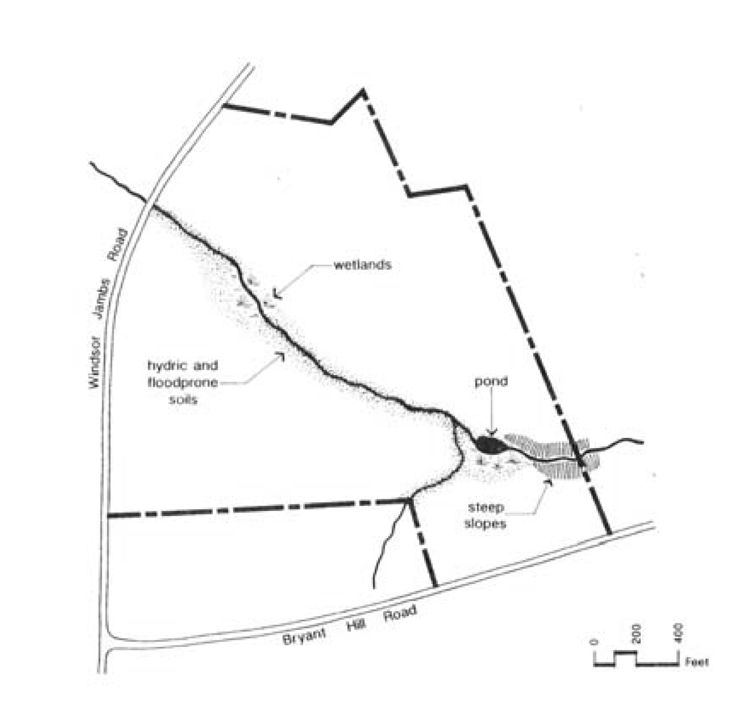
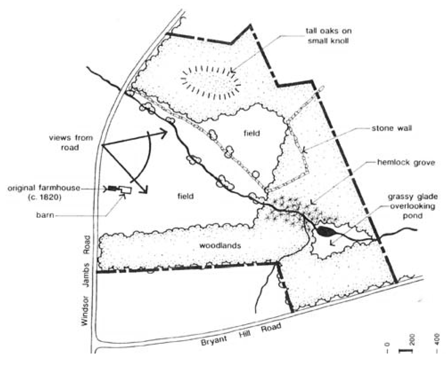
Site Analysis Map. The applicant shall prepare and submit a site analysis map. The purpose of the site analysis map is to ensure that the important site features have been adequately identified prior to the creation of the subdivision, and that the proposed open space will meet the requirements of this Article. The site analysis map shall include the following features:
1.
Property boundaries;
2.
All streams, rivers, lakes, wetlands and other hydrologic features;
3.
Topographic contours of no less than 10-foot intervals;
4.
All primary and secondary conservation areas labeled by type, as defined in this Zoning Ordinance;
5.
General vegetation characteristics;
6.
General soil types;
7.
The planned location of protected open space;
8.
Existing roads and structures; and,
9.
Potential connections with existing greenspace and trails.
(b)
Open Space Management Plan. As a part of the application, or no later than prior to the issuance of a development permit, an open space management plan shall be submitted and reviewed and approved by the Zoning Administrator.
(c)
Instrument of Permanent Protection. As a part of the application, or no later than prior to the issuance of a development permit, the applicant shall ensure that open space proposed in the conservation subdivision will be permanently protected, through an instrument such as a conservation easement or permanent restrictive covenant defined in this Zoning Ordinance.
(d)
Other Requirements. The Applicant shall adhere to all other applicable requirements of the underlying zoning and the city's Subdivision and Land Development Ordinance, unless specifically permitted otherwise by this Article.
Sec. 27.7. - Processing and Acting on Applications.
An application for approval of a conservation subdivision shall be submitted prior to or concurrent with a required preliminary plat in accordance with the city's subdivision and land development ordinance. The Zoning Administrator shall have up to fifteen (15) working days to review and approve or deny the application, if submitted separately from a preliminary plat application. If submitted concurrent with the preliminary plat, the application will be processed within the schedule specified for preliminary plat applications in the city's subdivision and land development ordinance.
Sec. 27.8. - Criteria for Considering Conservation Subdivisions.
Approval or denial of a conservation subdivision application shall be based on the extent to which the plat meets the following criteria:
(a)
All primary conservation areas are protected as permanent open space.
(b)
A sufficient amount of secondary conservation areas are protected as permanent open space, as opposed to being devoted to lots and other uses.
(c)
The configuration of the open space tract is contiguous and undivided, or open space is provided in relatively undivided tracts that cannot reasonably be reconfigured into one contiguous, undivided tract.
(d)
The conservation subdivision meets the regulations specified in this Article.
Sec. 27.9. - Grounds for Denial.
Reasons for the denial of a conservation subdivision application include but are not limited to the following:
(a)
The application fails to fully identify primary and secondary conservation areas.
(b)
One or more of the lots within the open space conservation subdivision are too small to meet the minimum lot size established by this Article.
(c)
One or more of the lots are significantly large or wide, such that their design contributes to an unnecessary decrease in the amount of open space retained on site.
(d)
The proposed open space network is divided, not functional, inconsistent with open space plans of the city with jurisdiction, or does not provide for the protection of the most valuable secondary conservation areas on the site given the natural and scenic properties inherent on the site.
(e)
The proposed open space network fails to maximize the length of the common boundary between conservation areas on site and conservation areas or parkland abutting the conservation subdivision site.
(f)
The preliminary plat appears to be submitted for the major purpose of circumventing minimum lot size or minimum lot width requirements or improvement requirements that would otherwise be required for conventional subdivisions pursuant this Zoning Ordinance.
Sec. 27.10. - Open Space Requirements.
(a)
Minimum Open Space. Each conservation subdivision shall provide at least 40 percent of the gross land area of the subdivision as restricted open space.
(b)
Primary Conservation Areas. Primary conservation areas, as defined in this Article, are required to be included within the open space, unless the applicant demonstrates that this provision would constitute an unusual hardship and be counter to the purposes of this Article.
(c)
Secondary Conservation Areas. Secondary Conservation Areas as defined in this Article, should be included within the open space, to the maximum extent feasible.
(d)
Contiguity. At least 75 percent of the open space in the conservation subdivision shall be in a contiguous tract.
(e)
Other Provisions. The open space should adjoin any neighboring areas of open space, other protected areas, and non-protected natural areas that would be candidates for inclusion as part of a future area of protected open space. The open space shall be directly accessible to the largest practicable number of lots within the subdivision. Non-adjoining lots shall be provided with safe, convenient access to the open space.
Sec. 27.11. - Permitted Uses of Open Space.
Open space within conservation subdivisions may be used for any of the following:
(a)
Conservation of natural, archeological or historical resources;
(b)
Meadows, woodlands, wetlands, wildlife corridors, game preserves, or similar conservation-oriented areas;
(c)
Walking or bicycle trails, provided they are constructed of porous paving materials;
(d)
Passive recreation areas;
(e)
Active recreation areas, provided that they are limited to no more than ten (10) percent of the total open space and are not located within primary conservation areas. Active recreation areas may include impervious surfaces. Active recreation areas in excess of this limit must be located outside of the protected open space;
(f)
Agriculture, horticulture, silviculture or pasture uses, provided that all applicable best management practices are used to minimize environmental impacts, and such activities are not conducted within primary conservation areas;
(g)
Nonstructural stormwater management practices;
(h)
Easements for drainage, access, and underground utility lines; or
(i)
Other conservation-oriented uses compatible with the purposes of this Article.
Sec. 27.12. - Prohibited Uses of Open Space.
Open space within conservation subdivisions shall not be used for any of the following:
(a)
Golf courses;
(b)
Roads, parking lots and impervious surfaces, except as specifically authorized in this Article;
(c)
Agricultural and forestry activities not conducted according to accepted Best Management Practices; and,
(d)
Other activities as determined by the applicant and recorded on the legal instrument providing for permanent protection.
Sec. 27.13. - Ownership and Management of Open Space.
(a)
Ownership of Open Space. The applicant must identify the owner of the open space who is responsible for maintaining the open space and facilities located thereon. If a Homeowners Association is the owner, membership in the association shall be mandatory and automatic for all homeowners of the subdivision and their successors. If a Homeowners Association is the owner, the Homeowners' Association shall have lien authority to ensure the collection of dues from all members. The responsibility for maintaining the open space and any facilities located thereon shall be borne by the owner.
(b)
Open Space Management Plan. The applicant shall submit a plan for management of open space and common facilities ("plan") that meets the requirements of this Article and that:
1.
Allocates responsibility and guidelines for the maintenance and operation of the open space and any facilities located thereon, including provisions for ongoing maintenance and for long-term capital improvements;
2.
Estimates the costs and staffing requirements needed for maintenance and operation of, and insurance for, the open space and outlines the means by which such funding will be obtained or provided;
3.
Provides that any changes to the plan be approved by the Governing Body; and,
4.
Provides for enforcement of the Plan.
(c)
Maintenance. In the event the party responsible for maintenance of the open space fails to maintain all or any portion in reasonable order and condition, the City of Flowery Branch may assume responsibility for its maintenance and may enter the premises and take corrective action, including the provision of extended maintenance. The costs of such maintenance may be charged to the owner, Homeowner's Association, or to the individual property owners located within the conservation subdivision, and may include administrative costs and penalties. Such costs shall become a lien on all subdivision properties.
Sec. 27.14. - Legal Instrument for Permanent Protection.
The open space within a conservation subdivision shall be protected in perpetuity by a binding legal instrument that is recorded prior to any vesting deed for property or lots within said subdivision. The instrument shall be one of the following:
(a)
A permanent conservation easement in favor of either: (1) a land trust or similar conservation-oriented non-profit organization with legal authority to accept such easements. The organization shall be bona fide and in perpetual existence and the conveyance instruments shall contain an appropriate provision for retransfer in the event the organization becomes unable to carry out its functions; or (2) a governmental entity with an interest in pursuing goals compatible with the purposes of this Article. If the entity accepting the easement is not the City of Flowery Branch, then a third right of enforcement favoring the City of Flowery Branch shall be included in the easement; or
(b)
A permanent restrictive covenant for conservation purposes in favor of a governmental entity.
The instrument for permanent protection shall include clear restrictions on the use of the open space. These restrictions shall include all restrictions contained in this Article, as well as any further restrictions the applicant chooses to place on the use of the open space.
Sec. 27.15. - Relationship to Dimensional Requirements of Zoning Districts.
(a)
Density and Lot Size. Conservation subdivisions approved pursuant to this Article shall not exceed the number of dwelling units per acre for the zoning district in which the conservation subdivision is located. Lots within conservation subdivisions shall not be bound by the minimum lot size requirements established in Table 6.2 of this Zoning Ordinance for the zoning district in which the conservation subdivision is located; provided, however, that no lot within a conservation subdivision shall be reduced to less than 50 percent of the required minimum lot size for the zoning district in which it is located.
(b)
Lot Width. Lots within conservation subdivisions shall not be bound by the minimum lot width requirements established in Table 6.2 of this Zoning Ordinance for the zoning district in which the conservation subdivision is located; provided, however, that no lot within a conservation subdivision shall be reduced to less than 75 percent of the required minimum lot width for the zoning district in which it is located.
(c)
Other Dimensional Requirements. The maximum lot coverage and front, side, and rear yard/building setback requirements for the zoning district in which the conservation subdivision is located shall continue to apply to development within the conservation subdivision; provided, however, that an applicant may propose and the Zoning Administrator may administratively authorize a reduction of the dimensional requirements specified in this paragraph, if the applicant demonstrates there is practical difficulty meeting said zoning district dimensional requirements due to the platting of smaller than conventional lots pursuant to this Article. In no case shall the Zoning Administrator reduce a dimensional requirement specified in this paragraph by more than 50 percent of that required by the zoning district in which the lot is located.