
Flowery Branch City Zoning Code
ARTICLE 25
- DEVELOPMENT ON STEEP SLOPES
Sec. 25.1.- Findings.
Hillsides are inherently unstable. Changes to slopes — through undermining by humans, flowing rivers, heavy rains, or the focusing of stormwater runoff by human-built channels or storm drain outlets — can cause erosion or landsliding. Soil slips, which cause avalanche-type failures, and slower-moving earthflows can occur on slopes of 30-33 percent and more. Serious erosion can occur on much shallower slopes. Steeper slopes are less forgiving of construction errors than are shallower slopes. When steeper slopes fail, such failures can have disastrous consequences.
Disturbed surfaces create loose materials which tend to move downhill. The steeper the natural slope, the greater the area is that must be disturbed. Development can result in alteration of land surfaces that can contribute to slope destabilization. Alterations that have the potential for creating unstable slopes include placing fills on top of marginally stable slopes, cutting slopes at too steep an angle or undermining the toe of a slope, redirecting storm runoff in a way that artificially concentrates flows onto portions of the landscape not prepared to receive such flows, removing woody vegetation, and adding water by means of hillside septic systems. These factors work together and can cumulatively decrease the stability of slopes and eventually lead to disaster. Landslides and slope failures pose a variety of hazards to persons and property.
Hillside development if unregulated can take place at the expense of environmental concerns. Stormwater runoff from slopes is greater in both quantity and velocity than it would be from level ground. Preserving existing vegetation reduces erosion by maintaining roots which increase infiltration and bind soils. Vegetation also reduces the velocity of raindrops and slows the velocity of surface water flow by increasing the roughness of the ground. Constructing hillside roads involves cuts in the upslope side and fills on the down slope side. Such cuts and fills are often much wider than the normal county road right-of-way and can be more susceptible to failure.
Hillsides are unique vegetation communities and wildlife habitats. Hillsides in developing areas are often the last remaining natural areas and are the final refuges for many animal species. Development needs to be sensitive to the hillside's function of providing biodiversity.
Sec. 25.2. - Applicability.
(a)
This Article shall apply to any subdivision plat, land-disturbing activity, building permit, or any other development proposal on property with a natural slope of twenty-five percent (25%) or more as determined by the Zoning Administrator, and including the crests, summits, and ridge tops which lie at elevations higher than any such areas.
(b)
This Article shall apply, and the Zoning Administrator shall apply and enforce the provisions of this Article, to the earliest application for development or building approval required of the applicant, whether that is an application for rezoning, conditional use, application for land-disturbance or development permit approval, subdivision plat, or application for building permit.
Sec. 25.3. - Calculation of Slope.
For purposes of determining whether the natural slope is 25 percent or more, and hence whether this Article applies, the natural slope of a given property shall be calculated perpendicular to topographic contours from property line to property line, prior to grading, using quandrangle maps of the United States Geological Survey, other reputable topographic maps of the subject area, or any map within the city's comprehensive plan showing slopes of 25% or more, or if available a topographic survey of the subject property.
Sec. 25.4. - Dispute of Slope Calculation.
Whenever an applicant disputes a determination by the Zoning Administrator as to the slope of the property, the applicant shall be entitled to submit a determination of the slope prepared by a registered land surveyor using standard surveying practices. Submission of the slope determination by a registered land surveyor shall be determinative and binding on the Zoning Administrator and applicant.
Sec. 25.5. - Exemptions.
The following land uses or activities are exempt from the requirements of this Article:
(a)
Agriculture and forestry. Agriculture and forestry, provided that they are consistent with the best management practices established by the Georgia Forestry Commission or the Georgia Soil and Water Conservation Commission, consistent with all state and federal laws, and all applicable regulations promulgated by the Georgia Department of Agriculture.
(b)
Landscape maintenance. Landscape maintenance activities, including the removal of diseased, dead or damaged trees; provided, however, that such activities shall be carried out in conformance with applicable regulations of this Article.
(c)
Prior development plan approval. Any land, or part of any land, which was contained in or subject to any development plan or permit, and which was filed with and approved by the City prior to the effective date of this Article.
(d)
Additions to single-family residences. On legal lots of record with existing residences that were approved prior to the effective date of this Article, said existing residences may be expanded without demonstrating compliance with this Article, provided that the height of the building addition does not exceed the existing height of the building, no land disturbance is required to accomplish the building addition, and the building addition is in conformity with the purposes and intent and consistent with regulations and guidelines of this Article as determined by the Zoning Administrator.
Sec. 25.6. - Permit and Plan Required.
No preliminary subdivision plat, development plan, land-disturbing activity permit, or building permit shall be issued by the Zoning Administrator or other administrative official of the city for any land-disturbing activity, land use, building, or structure on property subject to the jurisdiction of this Article, unless the activity, land use, building, or structure conforms to the requirements of this Article. All development activities or site work conducted after approval of the site plan shall conform to the specifications of said site plan as approved by the Zoning Administrator.
Sec. 25.7. - Topographic Information Required for All Land-Disturbing Activity.
(a)
As part of the first application requirement encountered by an applicant, whether that is for approval of a preliminary subdivision plat, permit for land-disturbing activity, development plan approval, or permit for a building, road, or driveway, in addition to other requirements specified for such application, as the case may be, the applicant shall be required to submit a topographical survey of the project site.
(b)
Notes and details of existing terrain shall be shown over the required topographic information. Said topographic survey may exclude areas not proposed for development, in order to reduce the costs to applicants.
(c)
Where existing available information on topography is deemed sufficient, the Zoning Administrator may waive the requirement for a topographic survey. A topographic survey shall be required by the Zoning Administrator for any application for land-disturbing activity where reliable data on existing topography, including quadrangle map of the U.S. Geological Survey or other topographic maps which may be available, do not provide sufficient detail to administer the requirements of this Article.
(d)
Said topographic survey, if required by the Zoning Administrator pursuant to this Section, shall provide contour intervals of no more than five (5) feet unless otherwise approved by the Zoning Administrator.
Sec. 25.8. - General Regulations for All Land-Disturbing Activity.
The following minimum standards shall apply to earth moving and land-disturbing activity:
(a)
Minimum Alterations. Earth moving shall be limited to the minimum required for building foundations, driveways, drainage control structures and immediate areas surrounding the building, structure, road driveway, or drainage structure required by this Article. With the exception of approved stockpiling or restoration efforts, substantial earth moving beyond that required for the installation or construction of approved buildings, structures, driveways, roads, or drainage structures shall not be permitted.
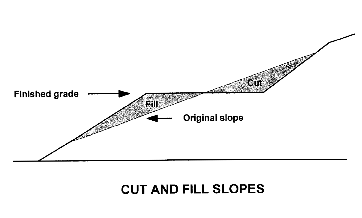
(b)
Cut and Fill. Unless otherwise specifically approved by the Zoning Administrator, cut and fill slopes shall be no steeper than two horizontal to one vertical and fill slopes shall not be located on natural slopes steeper than 2:1.
(c)
Compaction of Fill. All fill shall be stabilized in conformance with generally accepted engineering standards, including a compacted density of a least ninety-five percent (95%).
(d)
Timing of Disturbance and Prompt Completion. All earth moving and land disturbance shall be accomplished in the shortest practical period of time.
(e)
Natural Drainage Channels. Natural drainage ways shall be preserved to the maximum extent possible.
(f)
Control of stormwater run-off. Run-off from concentrated impervious surfaces shall be collected and transported in a pipe or other approved manner to a storm sewer system if available, or if unavailable, to the bottom of the drainage way or other location specified by the Zoning Administrator and in a safe, adequate, and non-erosive manner. When required by the city's regulations, storm water retention facilities shall be installed. When required, interceptor ditches shall be established above steep slopes in such a way as not to avoid saturation or erosion of soil, and the intercepted water shall be conveyed in a pipe or other manner to the bottom of the drainage way or other location specified by the Zoning Administrator. The overall drainage system shall be completed and made operational at the earliest possible time during construction.
(g)
Impact on Adjacent Property. Realignment of a natural drainage channel shall not be permitted unless specifically approved by the Zoning Administrator. Natural or typical flow of surface or subsurface water shall not be altered or obstructed in any way by grade changes if such alteration may adversely affect the property of another property by either contributing to pooling or collection of waters, or to the concentration or intensification of surface water discharge.
Sec. 25.9. - Application Requirements for Other-Than-Single-Family Dwellings.
Any application for land-disturbing activity, development, or building involving construction of a building for non-single-family dwelling use and which has a gross floor area of 2,000 square feet or more, shall contain the following information:
(a)
Soils report. This report shall include conclusions and recommendations regarding the effect of soil conditions on the proposed development. This report shall be prepared by a registered professional engineer, soil scientist, engineering geologist, or other qualified professional approved by the Zoning Administrator. The report may use the soil survey prepared and published by the Natural Resources Conservation Service (formerly Soil Conservation Service) for the area, as its basis, although site-specific soil tests may be required at the discretion of the Zoning Administrator.
(b)
Hydrology report and plan. This report shall include a complete description of the hydrology of the site, conclusions and recommendations regarding the effect of hydrologic conditions on the proposed development, and the capability of the site to be developed. Hydrology reports shall be completed by a professional engineer experienced and knowledgeable in the practice of hydrology, or other qualified professional approved by the director. A hydrological control plan, prepared by a professional engineer experienced and knowledgeable in the practice of hydrology, or other qualified professional approved by the Zoning Administrator, shall also be required. At minimum said plan shall show and take into account the direction of flow within the local drainage basin; all natural drainage channels directed toward and away from the site within fifty feet of the perimeter of the site, and other natural drainage ways which may affect or be affected by the development proposal. Alterations of natural drainage ways shall be prohibited except for approved road crossings and drainage structures. Natural drainage ways shall be riprapped or otherwise stabilized below drainage and culvert discharge points for a distance sufficient to convey the discharge without channel erosion. Special notations which highlight details of the terrain, existing natural surface drainage, and areas subject to seepage or spring flow, shall be included on the plan.
(c)
Tree survey and tree replacement plan. A survey shall be identified which identifies all trees which are proposed to be removed that exceed eight inches in diameter as measured at a point on the tree four and one-half feet above the surface of the ground. The survey is not required to show trees in undisturbed areas, provided the undisturbed areas are marked as such on the plan submitted with the application. Any application for development approval subject to the requirements of this Section shall contain a plan for replacement of any such trees that are removed. Vegetation used to revegetate disturbed areas shall be native species or species similar in resource value as the vegetation removed. Vegetation shall be chosen after consideration of its ability to survive the conditions of soils, climate, temperature, elevation, and other natural conditions. When revegetation is required, all required revegetation shall be installed prior to the issuance of a certificate of occupancy. All development activities or site work conducted after approval of the tree replacement plan shall conform to the specifications of said plan.
_____
Sec. 25.10. - Clearing and Improvement Limits.
Development on lands that are subject to this Article shall meet the requirements shown in Table 25.1.
Table 25.1
Clearing and Improvement Limits on Steep Slopes
_____
Sec. 25.11. - Design Review.
All development subject to the requirements of this Article shall require design plan review and approval. See Article 40 of this zoning ordinance.
Sec. 25.12. - Design and Development Guidelines.
Design plan review shall consider the extent to which the application meets the following design and development guidelines. The guidelines provided in this section and identified by use of the term "should." Compliance with the guidelines established in this section is not mandatory but is strongly recommended. Substantial inconsistencies with one or more guidelines in a manner that is clearly counter to the purposes of this Article in the opinion of the Zoning Administrator shall be sufficient grounds for the denial of said application.
(a)
Accepted Professional Practices. All development proposals subject to the requirements of this Article should be designed to meet generally accepted principles of land use planning, soil mechanics, engineering geology, civil engineering, environmental management, civic design, architecture, landscape architecture, landscape ecology, and related disciplines.
(b)
Planning. Planning of the development should take into account the topography, soils, geology, hydrology, vegetation, and other features of the proposed site. Areas not well suited for development due to soil characteristics, geology, vegetation, existing plant and animal life, or hydrology limitations, should not be developed.
(c)
Innovation. Site designers are encouraged to propose and apply innovative concepts for slope and soil stabilization, grading, landscaping, and building placement and design to meet the purposes and intentions of this Article. For instance, wooden deck areas either on the roof of a garage, or roof of the house, or extending from the house or garage, may be used to reduce the amount of grading and need for yard areas and provide private outdoor spaces. Wooden decks that allow infiltration of stormwater into the ground may be used instead of concrete slabs for patios and, in some cases if structurally sufficient, parking, in order to reduce the amount of impervious surface.
(d)
Land Disturbance and Grading. When grading is necessary, rigid contouring should be avoided; counters should be rounded to appear undulating and natural (see figure).
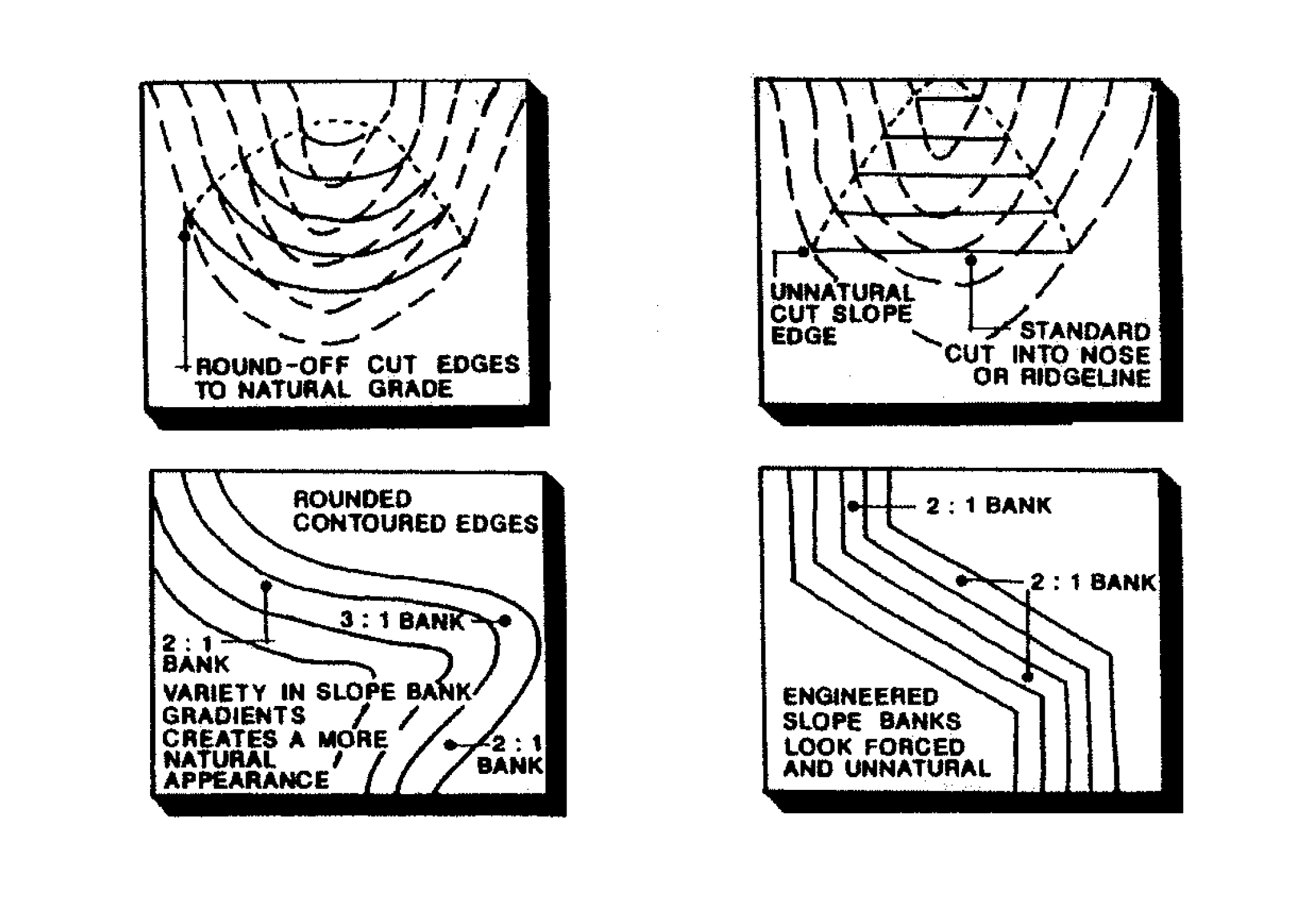
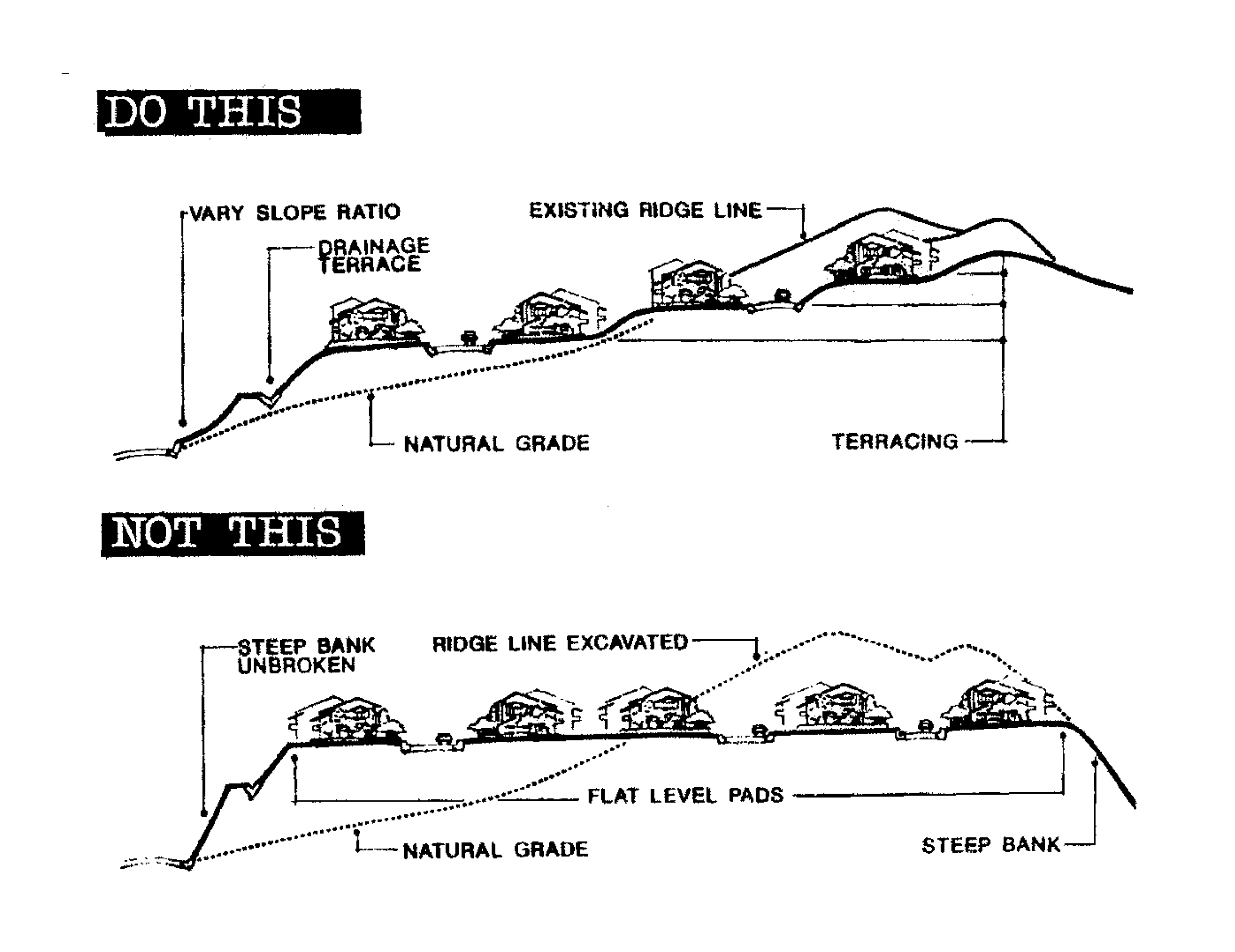
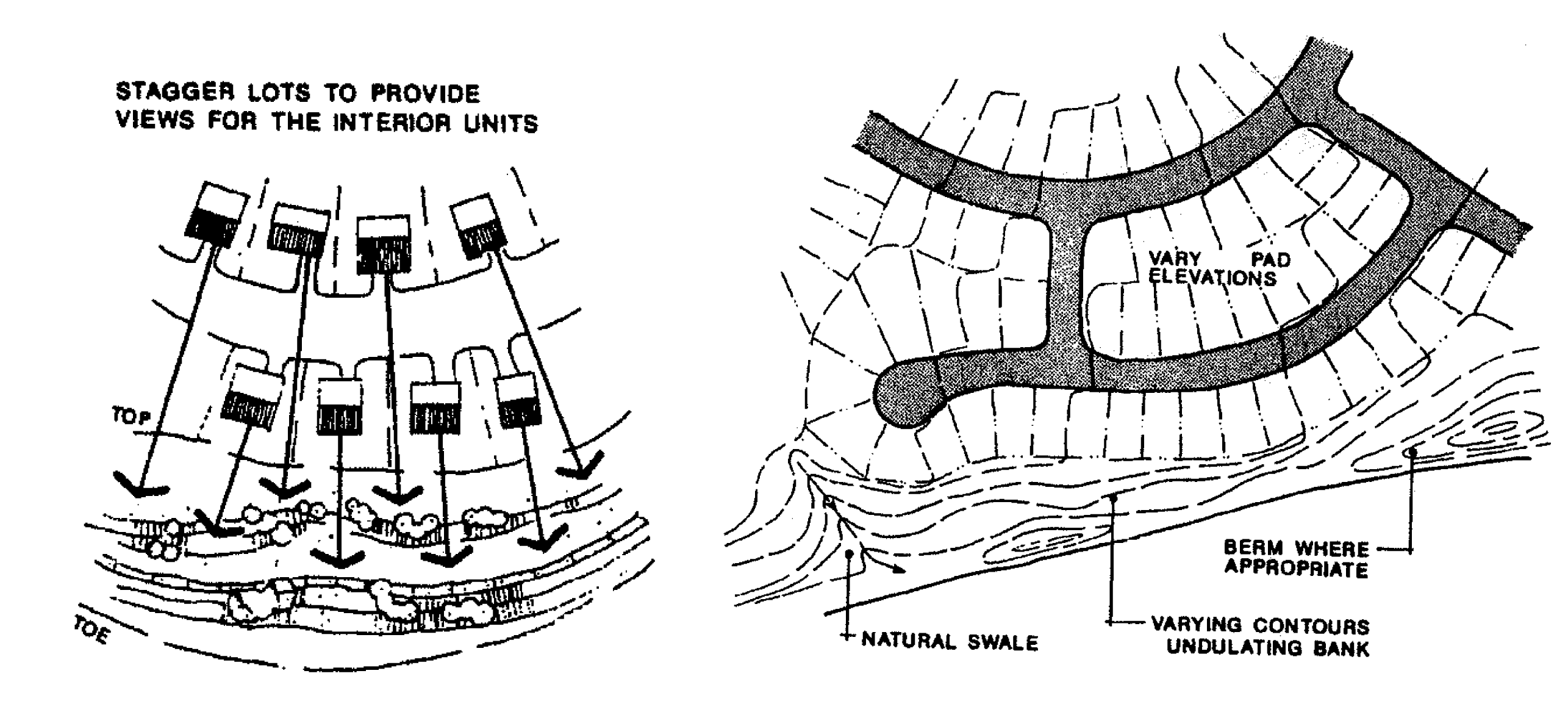
Projects involving more than one use or phase should be phased into workable units in a way that minimizes the amount of soil disturbance at any given point in time. When grading must occur, it should blend with the natural landform as much as possible. Grading to form level pads and building sites is strongly discouraged and when required such grading should be minimized.
Earth berms, rock forms, or stone retaining walls should be used to minimize visual impacts of cuts. Hedges and fences may also be appropriate in some locations. Large, continuous surfaces of smooth concrete and related structures are considered inappropriate. The height of any retaining wall should not exceed four feet unless required to be higher for engineering reasons. In areas where cuts are steeper, a stepped or terraced wall should be used.
(e)
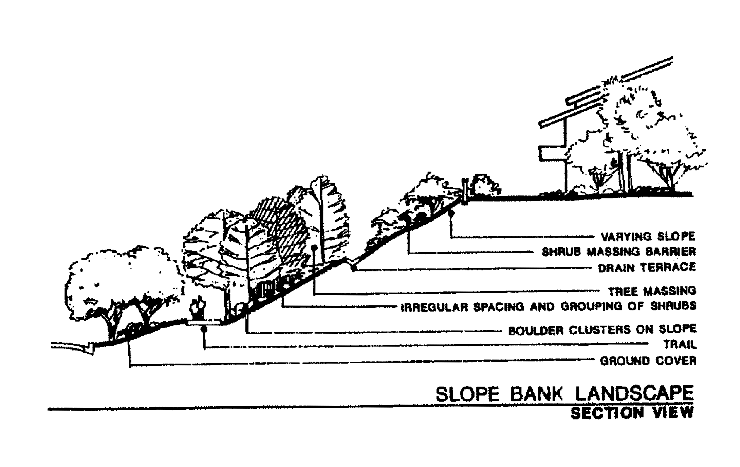
Vegetation, Landscaping, and Habitat. Plans for development should consider any characteristics of the area that make it unique or significant in the conservation of flora and fauna including threatened, rare, and endangered species. Existing deep-rooted vegetation, including trees, bushes and ground covers, should be removed only in cases where necessary for buildings, roads, driveways, parking, and minimal yards. Use plant materials that blend with the hillside. Landscape schemes that are rough, natural and/or subdued in character are encouraged. Extensive areas of exotic plants and sod are discouraged where they would be visible from the public right-of-way.
(f)
Sensitive Natural Areas. Plans for development should be sensitive toward and mitigate any negative effects of development activities on immediately adjacent sensitive natural areas.
(g)
Building Pads. For subdivisions and developments with multiple buildings, building pads (i.e., clearing and grading for buildings and structures) should be varied in elevation above or below road level to avoid the appearance of monotonous, flat, level pads.
(h)
Step-Down Design. Single-family dwellings and other structures should "step down" the hillside to limit the amount of grading required. Large building pads and footings should be split into more than one (i.e., split-level homes that step down the hillside) where possible to allow the building pad and structure to more closely follow the existing slope of the land. Building footprint coverage should be minimized where possible by using multiple-level (two or more story) buildings. The visible mass of larger buildings and structures should be reduced by utilizing below-grade rooms cut into the natural slope.
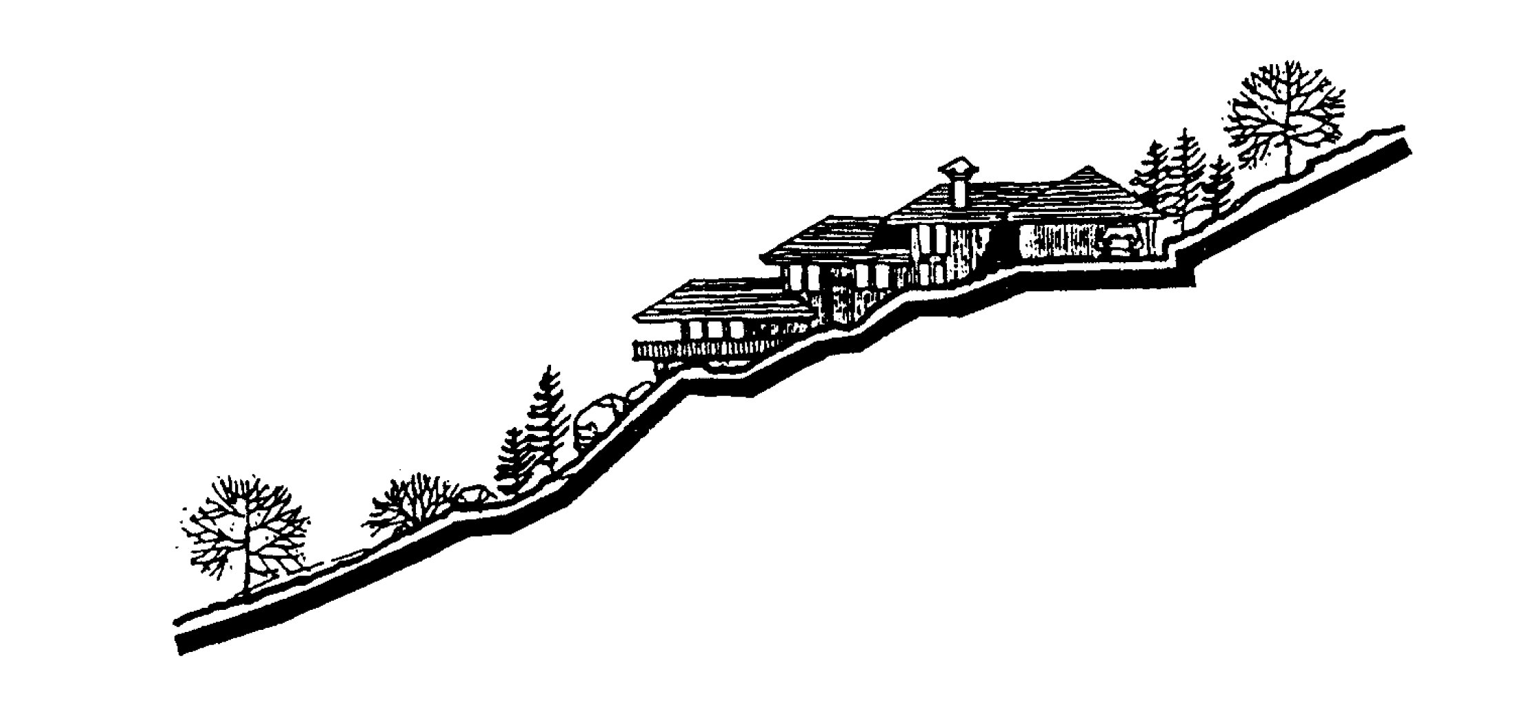
(i)
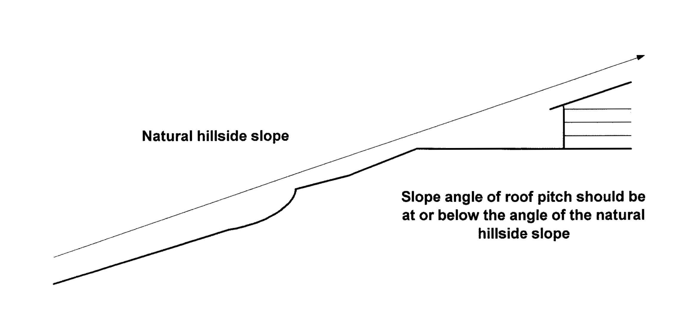
Rooflines. Roof forms and roof lines for new structures should be broken into a series of smaller building components to reflect the irregular forms of the surrounding hillside. Long, linear, unbroken roof lines are discouraged. Flat roofs are discouraged. The slope angle of roof pitch should be at or below the angle of the natural hillside slope. The slope of the roof should be oriented in the same direction as the natural slope of the lot.
_____
(j)
Building Colors. Exterior colors for new buildings and structures should be coordinated with the predominant colors of the surrounding landscape to minimize contrast between the structure and the natural environment. Exterior colors should be selected from among a color palette approved by the director. Dark or earthtone colors should be used to make the home or building less conspicuous as seen from off site. White and other light colors should be avoided.
(k)
Clustering of Buildings and Building Locations. Buildings and structures should be clustered where possible to reduce disturbance and removal of vegetation. Buildings should be sited with different floor elevations to achieve height variation. For multi-family projects, if permitted, stagger alignments of buildings both horizontally and vertically to create unit identity, privacy at entry and private outdoor space, and to share common open space.
(l)
Building Setbacks. Where appropriate, buildings and structures should be located as close to the road as possible to preserve the natural terrain and to minimize disturbance and the length of driveways. The Zoning Administrator may administratively vary (reduce) minimum building setbacks by up to 50 percent to encourage compliance with this provision.
(m)
Screening and View Corridors. The thinning of limbs of individual trees is preferred over tree removal as a means to provide a view corridor. Dwellings or buildings that are proposed to be sited to maximize views from the lot or that require removal of vegetation to produce a view corridor are strongly discouraged and will be denied.
(n)
Road and Driveways Should Follow the Natural Terrain. Road and driveway alignments should follow the natural terrain unless the project engineer can justify additional cuts or fills. Roads, walkways, and parking areas should be designed to parallel the natural contours of the site.
(o)
Shared Driveways and Parking. Combinations of collective private driveways, shared parking areas and on-street parallel parking bays should be used where possible to minimize land and soil disturbance, minimize impervious surface coverage, and achieve excellence of design and aesthetic sensitivity.
(p)
Lighting. Outside lighting should be muted and directed so that it does not spill over on to neighboring properties. Reduce the amount of light emanating from a development on a hillside, since lighting from buildings located on hillsides can be highly visible at night and may affect the night character of the community.
Sec. 25.13. - Variances.
(a)
Remedy. If an applicant asserts in writing to the Zoning Administrator that application of this Article would deny the reasonable use of property, or prevent innovation as encouraged by this Article, the applicant may apply for a variance in accordance with variance procedures of this zoning ordinance (see Article 37). A variance to the provisions of this Article may upon application and after due notice thereof be granted by the Governing Body.
(b)
Intent. A variance is intended to provide a remedy to address those cases in which the application of this Article unreasonably restricts all economic use of a parcel of land and the restriction cannot be remedied by other authorized techniques or conditions; and to remedy situations where innovation is prevented by the strict application of the terms of this Article.
(c)
Review and Recommendation. Prior to granting a variance to the provisions of this Article, the Governing Body shall seek the recommendation of the Zoning Administrator, and when engineering considerations are involved, the City Engineer, prior to acting upon a an application for variance to the terms of this Article.
Sec. 25.14. - Appeals.
An applicant or other party aggrieved by a decision of the Zoning Administrator in the administration, interpretation, or enforcement of this Article may appeal said decision to the planning commission by filing a written appeal application in accordance with procedures for administrative appeals provided in this zoning ordinance (See Article 39).