
Fridley City Zoning Code
CHAPTER 640
Subdivision Design Standards
640.01 Purpose
1. Subdivision design standards are established to guide a coordinated, adjusted and harmonious development of the City.
2. Subdivision design standards are established to ensure that subdivisions are designed to accommodate existing and future growth and address community needs.
3. Subdivision design standards are established to promote the public, health, safety, order, convenience, and the general welfare with efficiency and economic consideration in the process of subdivision development.
Adopted by Ord. 1431 on 6/18/2025
640.02 General Design Standards
1. The following design standards are hereby established for land subdivisions:
(a) The proposed subdivision, including the general layout, street pattern, street widths, proposed private and public areas, facilities and uses, must conform to these regulations and other applicable laws, and to the City's Comprehensive Plan.
(b) The design features set forth in this Chapter are minimum requirements. The City may impose additional or more stringent requirements concerning lot size, streets, and overall design as deemed appropriate considering the property being subdivided.
(c) Land Suitability
(1) Land must be suited to the purpose for which it is to be subdivided. No subdivision will be approved if the site is not suitable for the purposes proposed by reason of potential flooding, topography, or adverse soil, rock formation or wetlands.
(2) Land subject to hazards to life, health, or property must not be subdivided until all such hazards have been eliminated or unless adequate safeguards against such hazards are provided by the subdivision plans.
2. Exceptions to Design Standards
(a) The City Council may authorize a modification or exception to the design standards listed in this Chapter to permit reasonable subdivision of property as recommended by City staff based on characteristics unique to the property. These conditions may include, but are not limited to, natural features (topography, wetlands floodplain, etc.), presence of major utilities (i.e., high pressure gas main), and the overall size of the subdivision.
Adopted by Ord. 1431 on 6/18/2025
640.03 Blocks And Lots
1. Blocks
(a) Block Length
(1) Block lengths will be determined by circulation and other needs, with lengths of up to 1,500 feet permissible when approved by the City Council.
(2) On blocks 700 feet or more in length, the City Council may require walkways not less than 10 feet wide for a pedestrian way or crosswalk near the center of the block, or to provide access to schools, playgrounds, shopping centers, and other areas and facilities (see Figure 1).
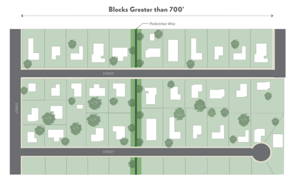 Figure 1
(b) Block Width
(1) Residential blocks must be of sufficient width for two tiers of lots except when adjoining a lake, stream, railroad or arterial street, or where one tier of lots is necessary because of topographic conditions.
(2) Where residential blocks with lots deeper than 260 feet are proposed, the City Council may require the dedication of future right-of-way through the middle of the block longitudinally.
(3) Blocks for commercial and industrial areas must be of such width as to be considered most suitable for their respective use, including adequate space for off-street parking and deliveries.
2. Lots
(a) Lots must conform to the requirements and dimensional standards of the zoning chapters of the Code.
3. Each lot must be adequate to provide space for the principal structure and all necessary accessory structures. A corner lot must be at least an additional five feet in width to ensure compliance with building setbacks from both streets.
(a) Side lot lines must be at right angles or radial to street lines. Slight variations under difficult conditions are permissible with City Council approval.
(b) Irregularly shaped lots are discouraged. Where such lots are proposed, the applicant must demonstrate to the City an ability to properly place principal buildings and accessory structures on the lot in a manner which is compatible in size and character to the surrounding area.
(c) All remnants of lots below minimum size left over after subdividing a larger tract must be:
(1) Added to adjacent lots;
(2) Dedicated to the public;
(3) Owned with by a homeowner association or comparable association with specified restrictions; or
(4) Platted as an outlot with specific restrictions.
(d) Accessibility. Each lot in a subdivision must be satisfactorily served from a public street to allow for general accessibility for firefighting, refuse collection and delivery purposes unless a particular lot in the subdivision has received approval from City Council that will allow access to the lot via an access easement.
Adopted by Ord. 1431 on 6/18/2025
640.04 Street Design
1. All streets must be designed to comply with the standards set by the City’s Engineering Specifications.
2. Proposed streets must conform to the state, county, and city plans as have been prepared, adopted, and filed as prescribed by law.
3. Street Patterns. Street patterns must substantially follow the patterns shown on the land use plan or be at least the equal of the planned patterns in these respects:
(a) They must adequately serve platted lots when developed;
(b) They must intersect existing or planned trunk highways and major thoroughfares at infrequent intervals only;
(c) They must not obstruct the reasonable and desirable development of adjoining, unsubdivided lands in conformity with any applicable plans or with these design standards;
(d) They must be designed to discourage through traffic from using local streets in the subdivision;
(e) They must be suited to the topography of the land, but with their orientation influenced by walking direction and distance to and from existing and planned parks, playgrounds and schools;
(f) No more than four corners are allowed for an intersection; and
(g) New streets must extend to the boundary line of any new subdivision.
4. Temporary Dead-End Streets
(a) Where a future street is proposed in connection to the proposed subdivision development, a temporary turn-around by fire code standards must be constructed of temporary concrete or alternative approved by the City Engineer.
(b) The proposed subdivision may result in only one means of ingress/egress for a period of time until a later phase of development occurs or until an abutting property extends the roadway. Temporary dead-end streets that serve land uses that generate more than 500 average daily traffic (ADT) must provide an alternative access or make other necessary accommodations for safe ingress and egress to the satisfaction of the City Council.
5. Access. The street pattern must be designed to minimize access points and crossings along all railroad and arterial thoroughfares.
6. Public Streets. All proposed streets must be offered for dedication as public streets, with no private streets shown.
7. Right Angle Intersection. Streets must intersect or intercept each other at right angles. Intersections may be permitted to vary, at most 20 degrees when considered necessary.
8. Jogs. Jogs in streets must have center line offsets of 125 feet or more.
9. Corners. Property lines at residential street corners must be rounded on a radius of at least 10 feet and curb lines on a radius of at least 20 feet, provided that greater radii may be required by the City Council when deemed necessary.
10. The location, width and alignment of streets must conform, to the City General Specifications and Standard Details, major street plan, or any other applicable plans, as specified by the City Engineer including state and county highway plans.
11. Half-width Streets. Half-width streets are not acceptable except as found practically necessary by the City Council and only with the assurance of dedication of the other half of the street when adjoining property will be subdivided.
12. Corporate Boundary Streets. For protecting the City in developing and maintaining streets bordering the corporate limits, where a half-width street dedication is proposed, the applicant must furnish one of the following with the preliminary plat:
(a) Assurance that the remaining half of the street that is outside the corporate limits has or will be dedicated; or
(b) A warranty deed for the remaining half of the street that is outside the corporate limits; or
(c) An easement for right-of-way purposes for the remaining half of the street, signed by the owners of the property in which the street will be located.
13. Grades. Street grades of six percent are considered a desirable maximum. This maximum may be exceeded only when required by topography or other controlling physical conditions. Grades of all streets, walks, curbs, and gutters must be approved by the City.
14. Drainage. All interior streets must have concrete curbs and the road surface constructed according to City standards to handle drainage according to a City approved drainage plan.
15. Street Names. Names of streets which are extensions of existing streets must be the same, provided that these and other street names are subject to City approval.
Adopted by Ord. 1431 on 6/18/2025
640.05 Non-Motorized Connections
1. Sidewalk design
(a) Sidewalks are required on at least one side of every local street. Sidewalks are not required along a cul-de-sac but may be required to extend between residential properties at the end to connect to an adjacent neighborhood.
(b) Sidewalks must be placed in the public right-of-way or within an easement in favor of the City.
(c) Sidewalks must be at least six feet in width and meet specifications set forth by the City General Specifications and Standard Details approved by the City Engineer, including accessibility requirements.
(d) The City Council may allow the applicant to delay the installation of the sidewalk if the applicant signs an agreement that it will be constructed when the City requires the installation. A letter of credit or cash escrow may be required in order to ensure that the sidewalk is installed at a later date.
2. Trail Design
(a) Multi-use trails are required on one side of all collector and arterial roadways. Where a sidewalk already exists on a collector or arterial roadway, the City Council will determine whether a sidewalk or a trail will be installed.
(b) Trail linkages or easements for trail linkages must also be established in accordance with the City’s Comprehensive Plan and Active Transportation Plan.
(1) The City will designate the required width of easements and elevations for grades at the time a building is constructed on the property.
(2) Any landscaping or irrigation systems installed within an easement must be removed and replaced at the property owner’s expense when the trail or sidewalk is installed in the future.
(c) Multi-use trails must be placed in the public right-of-way or an easement in favor of the City.
(d) Multi-use trails must be at least 10 feet in width and meet specifications set forth by the Public Works Design Manual or the City Engineer, including accessibility requirements.
Adopted by Ord. 1431 on 6/18/2025
640.06 Easements
1. Watercourses and stormwater facilities must be identified and delineated within an easement.
2. Easements offered for dedication should be shown along lot lines where needed for utility, drainage, screen planting, or other purposes.
3. Drainage and utility easements must be provided along front, rear, and shared side lot lines. Easements must be 10 feet wide along the front property line and five feet wide along rear and side lot lines. Easements of greater width of area may be required if necessary for the extension of utilities, drainage purposes, or to incorporate wetlands.
4. Drainage and utility easements must connect with easements established in adjoining properties. These easements, when approved, may not thereafter be changed without the approval of the City Council after a public hearing (see Figure 2).
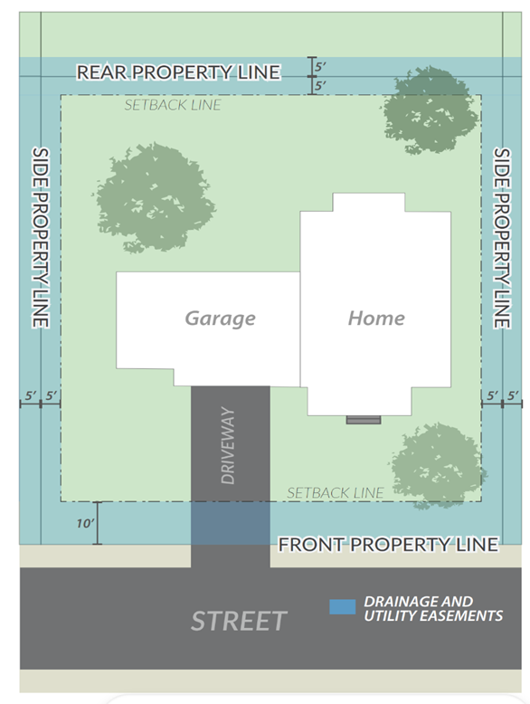
Figure 2
Adopted by Ord. 1431 on 6/18/2025

