
Gastonia City Zoning Code
CHAPTER 7
USE AND BUILDING LOT STANDARDS
SECTION 7.1 - TABLE OF USES
Uses designated as "permitted uses" are allowed in a zone as a matter of right and are designated with an "X" in Table 7.1-1. Uses designated with a "C" in Table 7.1-1 are "special uses" are allowed only after a special use permit has been issued per Section 5.11. Uses designated with an "E" are existing uses that are subject to certain limitations on expansions. If an "S" follows either the "X," "C" or "E" in Table 7.1-1 it means that that use is subject to additional performance criteria specific to that use. The location of those performance criteria for that use is shown in Table 7.1-1.
(Ord. No. 21-739, § 1, 6-15-21)
SECTION 7.2 - USES NOT EXPRESSLY LISTED OR ADDRESSED
No building or structure, sign or land shall hereafter be used, erected or occupied and no building or structure shall be erected, expanded or moved except in conformity with the regulations of this Ordinance. Table 7.1-1 shows the principal uses that are allowed in each zoning district. Temporary uses are discussed in Section 5.8; accessory uses, customary home occupations, and private residential quarters are discussed in Chapter 9.
Certain uses predating the adoption of this Ordinance are allowed to remain as nonconforming uses in accordance with Section 3.3 of this Ordinance. Unless a use is allowed as a "permitted," "conditional," "nonconforming use," "temporary use," or otherwise specifically address in this Ordinance, then such use shall be expressly prohibited in that zoning district. The Board of Adjustment shall have no authority to grant a variance to allow for such prohibited use.
(Ord. No. 25-827, § 2, 3-4-25)
SECTION 7.3 - BULK AND DIMENSIONAL STANDARDS
Bulk and dimensional standards for all uses in all general zoning districts are shown in Table 7.3-1. Such dimensional standards shall prevail unless specific standards for individual uses are found elsewhere in this Ordinance.
SECTION 7.4 - LOCATION OF REQUIRED YARDS ON CORNER AND IRREGULAR LOTS
If a lot is abutted on three (3) sides by streets, the front yard (for setback purposes) shall be designated by the property owner. Notwithstanding, the front and rear yards, and subsequent placement of structures on said lot, to the greatest degree possible, shall be in keeping with the architectural fronts and rears of other pre-existing structures situated on that block.
The location of required front yard setbacks and side and rear yards on other irregularly shaped lots shall be determined by the Administrator based on the spirit and intent of this Ordinance to achieve an appropriate spacing and location of buildings and structures on individual lots.
(Ord. No. 14-632, § 5, 8-19-14)
SECTION 7.5 - PRE-EXISTING LOTS OF RECORD
A.
In any zone in which residences are permitted, where a lot has an area or width of less than the required area or width, and said lot was a lot of record at the time of the adoption of this Ordinance, including any revision or amendment thereto, said lot may be occupied by a single-family dwelling, provided that the minimum yard and bulk requirements for the zone in which it is located are met.
B.
In any nonresidential zoning district, a residential structure which existed on or before the date of adoption of this Ordinance, may be converted to a permitted nonresidential use (or a mixed-use dwelling), so long as all applicable building code requirements, off-street parking and landscaping, and screening requirements are met. If such use is a conditional use, the Planning Commission or City Council may attach fair and reasonable conditions which would serve to mitigate any existing nonconforming situations arising from such conversion.
Table 7.1-1
Table of Uses
(1)
For projects that require new streets, a Conditional District process is required.
(2)
For projects within the boundaries and locations identified by section 8.1.4, use is allowed by right in TMU, O-1, UMU, C-1, C-3, CBD, & I-U.
TABLE 7.3-1
BULK AND USE CHART
Notes
A = Minimum Lot Area
W = Minimum Lot Width (as measured at the minimum front yard setback)
F = Minimum Front Setback (see definition of front yard to determine how front yard
is measured on corner lots)
S = Minimum Side Setback
R = Minimum Rear Setback
H = Maximum Building Height
* There are no dimensional requirements for Essential Services, Class 1 and Parks
** Dimensional requirements listed for certain uses in Chapter 8 shall supersede those listed herein.
1. An additional ten (10) feet to the requirements listed above shall be required on all side yards which abut a public or private street.
2. For newly created non-residential lots: Minimum two hundred (200) feet on a major thoroughfare, a minimum one hundred (100) feet on a minor thoroughfare, and a minimum of one hundred fifty (150) feet on all lots located at the intersection of two (2) streets.
3. Existing lots with a width of less than sixty (60) feet may use a five (5) foot side yard setback.
4. Where no parking areas or drive isles are located between the building and the street right-of-way, the minimum front setback may be reduced to fifteen (15) feet (applicable for attached housing and non-residential development only).
5. Existing lots with a lot width of sixty (60) feet or less may use the RS-8 setbacks.
6. In the RS-8 district, the required lot area and lot width may be determined for new lot(s) if each of the following are met: (a) the existing tract to be subdivided is no greater than two (2) acres, (b) the lot area and lot width may be determined by the averaging of at least two (2) lots located on the same block, facing the same street, and within two hundred (200) linear feet from the lot in question, and (c) no more than three (3) lots will result after the subdivision is completed.
Notes:
A = Minimum Lot Area
W = Minimum Lot Width (as measured at the minimum front yard setback)
F = Minimum Front Setback (see definition of front yard to determine how front yard
is measured on corner lots)
S = Minimum Side Setback
R = Minimum Rear Setback
H = Maximum Building Height
*Dimensional requirements listed for certain uses in Chapter 8 shall supersede those listed herein.
1. Five thousand (5,000) square feet for all single or two-family dwellings; three thousand (3,000) square feet for all other uses
2. Refer to Sections 9.5 and 13.15.3 for further road frontage requirements.
3. The front yard setback shall be ten (10) to fifteen (15) feet, as measured from the edge of the adjoining front sidewalk.
4. Add ten (10) feet if abutting a residential zoning district.
5. The maximum height may be increased to seventy-five (75) feet if located two hundred (200) feet from a residentially zoned lot. In the O-M district, the height may be increased to one hundred twenty-five (125) feet if located three hundred (300) feet from a residentially zoned lot.
6. Ten thousand (10,000) square feet for multi-family developments
7. Where no parking areas or drive isles are located between the building and the street right-of-way, the minimum front setback may be reduced to fifteen (15) feet.
8. In the TMU and O-1 district, the required lot area and lot width may be reduced for a new lot(s) if each of the following are met: (a) the existing tract to be subdivided is no greater than two (2) acres, (b) the lot area and lot width may be determined by the averaging of at least two (2) lots located on the same block, facing the same street, and within two hundred (200) linear feet from the lot in question, and (c) no more than three (3) lots will result after the subdivision is completed.
Notes:
A = Minimum Lot Area
W = Minimum Lot Width (as measured at the minimum front yard setback)
F = Minimum Front Setback (see definition of front yard to determine how front yard
is measured on corner lots)
S = Minimum Side Setback
R = Minimum Rear Setback
H = Maximum Building Height
* Dimensional requirements listed for certain uses in Chapter 8 shall supersede those listed herein.
1. Refer to Sections 9.5 and 13.15.3 for further road frontage requirements.
2. Add ten (10) feet if abutting a residential zoning district.
3. The maximum height may be increased to seventy-five (75) feet if located two hundred (200) feet from a residentially zoned lot. In the C-2 and C-3 districts, the height may be increased to one hundred twenty-five (125) feet if located three hundred (300) feet from a residentially zoned lot.
4. Ten thousand (10,000) square feet for multi-family developments
5. The front yard setback shall be zero (0) to fifteen (15) feet, as measured from the edge of the adjoining front sidewalk.
6. Five thousand (5,000) square feet for all single or two-family dwellings; three thousand (3,000) square feet for all other uses
7. Where no parking areas or drive isles are located between the building and the street right-of-way, the minimum front setback may be reduced to fifteen (15) feet.
8. In the UMU district, the required lot area and lot width may be reduced for a new lot(s) if each of the following are met: (a) the existing tract to be subdivided is no greater than two (2) acres, (b) the lot area and lot width may be determined by the averaging of at least two (2) lots located on the same block, facing the same street, and within two hundred (200) linear feet from the lot in question, and (c) no more than three (3) lots will result after the subdivision is completed.
Notes:
A = Minimum Lot Area
W = Minimum Lot Width (as measured at the minimum front yard setback)
F = Minimum Front Setback (see definition of front yard to determine now front yard
is measured on corner lots)
S = Minimum Side Setback
R = Minimum Rear Setback
H = Maximum Building Height
* Dimensional requirements listed for certain uses in Chapter 8 shall supersede those listed herein.
1. Refer to Sections 9.5 and 13.15.3 for further road frontage requirements.
2. Add ten (10) feet if abutting a residential zoning district.
3. The maximum height may be increased to seventy-five (75) feet if located two hundred (200) feet from a residentially zoned lot.
4. Ten thousand (10,000) square feet for multi-family developments
5. The front yard setback shall be zero (0) to twenty (20) feet, as measured from the edge of the adjoining front sidewalk.
6. Where no parking areas or drive isles are located between the building and the street right-of-way, the minimum front setback may be reduced to fifteen (15) feet.
(Ord. No. 10-585, § 3, 8-17-10; Ord. No. 11-586, § 4, 1-18-11; Ord. No. 11-593, § 2, 8-2-11; Ord. No. 11-594, § 2, 9-6-11; Ord. No. 11-598, § 1, 11-15-11; Ord. No. 12-608, § 2, 4-17-12; Ord. No. 12-610, § 2, 5-15-12; Ord. No. 12-617, § 1, 8-21-12; Ord. No. 14-630, § 2, 2-18-14; Ord. No. 14-631, § 1, 3-18-14; Ord. No. 14-632, §§ 3, 4, 8-19-14; Ord. No. 17-653, § 1, 2-21-17; Ord. No. 18-672, § 1, 8-23-18; Ord. No. 19-683, §§ 1, 2, 3-19-19; Ord. No. 19-685, §§ 1, 2, 5-21-19; Ord. No. 20-695, § 2, 2-18-20; Ord. No. 20-697, § 2, 3-17-20; Ord. No. 20-725, § 1, 9-1-20; Ord. No. 20-733, § 1, 1-19-21; Ord. No. 21-735, § 2, 3-16-21; Ord. No. 21-737, § 3, 5-18-21; Ord. No. 21-739, § 1, 6-15-21; Ord. No. 21-742, §§ 2, 3, 8-10-21; Ord. No. 21-753, § 2, 12-21-21; Ord. No. 22-756, § 1, 1-18-22; Ord. No. 22-761, § 2, 4-5-21; Ord. No. 22-763, § 2, 5-17-22; Ord. No. 23-785, § 1, 4-18-23; Ord. No. 23-787, § 2, 6-20-23; Ord. No. 24-802, § 1, 1-16-24; Ord. No. 24-814, § 1, 9-17-24; Ord. No. 25-822, § 1, 1-21-25; Ord. No. 25-832, § 1, 7-15-25)
7.6.1 - FH FLOOD HAZARD OVERLAY DISTRICT
A.
Flood Hazard (FH) Overlay District.
The Legislature of the State of North Carolina has in G.S. ch. 143, art. 21, pt. 6; G.S. ch. 160D; and G.S. ch. 160A, art. 8, delegated to local governmental units the responsibility to adopt regulations designed to promote the public health, safety, and general welfare.
1.
Causes of flood loss. The flood hazard areas within the zoning jurisdiction of the City of Gastonia, North Carolina are subject to periodic inundation which results in loss of property, health and safety hazards, disruption of commerce and governmental services, extraordinary public expenditures for flood protection and relief, and impairment of the tax base; all of which adversely affect the public health, safety and general welfare. These flood losses are caused by:
a.
The cumulative effect of obstruction in floodplains causing increases in flood heights and velocities; and
b.
The occupancy of flood hazard areas by uses vulnerable to floods, or hazardous to other lands, which are inadequately elevated, flood proofed, or otherwise unprotected flood damages.
2.
Statement of purpose. It is the purpose of this Ordinance to promote public health, safety, and general welfare and to minimize public and private losses due to flood conditions within flood prone areas by provisions designed to:
a.
Restrict or prohibit uses that are dangerous to health, safety, and property due to water or erosion hazards or that result in damaging increases in erosion, flood heights or velocities;
b.
Require that uses vulnerable to floods, including facilities that serve such uses, be protected against flood damage at the time of initial construction;
c.
Control the alteration of natural floodplains, stream channels, and natural protective barriers, which are involved in the accommodation of floodwaters;
d.
Control filling, grading, dredging, and all other development that may increase erosion or flood damage; and
e.
Prevent or regulate the construction of flood barriers that will unnaturally divert flood waters or which may increase flood hazards to other lands.
3.
Declaration of legislative objectives. The objectives of this overlay zoning district are:
a.
To protect human life, safety, and health;
b.
To minimize expenditure of public money for costly control projects;
c.
To minimize the need for rescue and relief efforts associated with flooding and generally undertaken at the expense of the general public;
d.
To minimize prolonged business interruptions;
e.
To minimize damage to public facilities and utilities such as water and gas mains, electric, telephone and sewer lines, and streets and bridges located in floodplains;
f.
To help maintain a stable tax base by providing for the sound use and development of flood prone areas in such a manner as to minimize future flood blight areas; and
g.
To ensure that potential buyers are notified that property is in a flood area.
4.
Definitions. The following definitions shall be applicable to the FH overlay district only. Definitions of other terms are found in Section 2.7. For purposes of the FH district only, wherever a conflict exists between a definition of a word herein described and one found in Section 2.7, the definitions listed herein shall apply.
1.
Accessory Structure (Appurtenant Structure). A structure located on the same parcel of property as the principal structure and the use of which is incidental to the use of the principal structure. Garages, carports and storage sheds are common urban accessory structures. Pole barns, hay sheds and the like qualify as accessory structures on farms, and may or may not be located on the same parcel as the farm dwelling or shop building.
2.
Addition to an existing building. An extension or increase in the floor area or height of a building or structure.
3.
Appeal. A request for a review of the Floodplain Administrator's interpretation of any provision of this Ordinance.
4.
Area of shallow flooding. A designated AO zone on a community's flood insurance rate map (FIRM) with base flood depths determined to be from one to three (3) feet where a clearly defined channel does not exist, where the path of flooding is unpredictable and indeterminate, and where velocity flow may be evident.
5.
Area of special flood hazard. See "Special Flood Hazard Area (SFHA)."
6.
Base flood. The flood having a one percent chance of being equaled or exceeded in any given year.
7.
Base Flood Elevation (BFE). A determination of the water surface elevations of the base flood as published in the Flood Insurance Study. When the BFE has not been provided in a "Special Flood Hazard Area," it may be obtained from engineering studies available from a Federal, State or other source using FEMA approved engineering methodologies. This elevation, when combined with the "Freeboard," establishes the "Regulatory Flood Protection Elevation."
8.
Basement. That lowest level or story which has its floor subgrade (below ground level) on all sides.
9.
Building. See "Structure."
10.
Chemical storage facility. A building, portion of a building, or exterior area adjacent to a building used for the storage of any chemical or chemically reactive product.
11.
Development. Any man-made change to improved or unimproved real estate, including but not limited to, buildings or other structures, mining, dredging, filling, grading, paving, excavation or drilling operations, or storage of equipment or materials.
12.
Disposal. As defined in G.S. 130A-290(a)(6), the discharge, deposit, injection, dumping, spilling, leaking, or placing of any solid waste into or on any land or water so that the solid waste or any constituent part of the sold waste may enter the environment or be emitted into the air or discharged into any waters, including ground waters.
13.
Elevated building. A non-basement building which has its lowest elevated floor raised above ground level by foundation walls, shear walls, posts, piers, pilings, or columns.
14.
Encroachment. The advance or infringement of uses, fill, excavation, buildings, structures or development into a floodplain, which may impede or alter the flow capacity of a floodplain. Utilities shall not be deemed fill for the purposes of this Chapter and trails located in the flood fringe shall not be deemed fill for the purpose of this Chapter.
15.
Existing manufactured home park or manufactured home subdivision. A manufactured home park or subdivision for which the construction of facilities for servicing the lots on which the manufactured homes are to be affixed (including, at a minimum, the installation of utilities, the construction of streets, and either final site grading or the pouring of concrete pads) was completed before the implementation date of this zoning district.
16.
Flood or flooding. A general and temporary condition of partial or complete inundation of normally dry land areas from:
1.
The overflow of inland or tidal waters; or
2.
The unusual and rapid accumulation or runoff of surface waters from any source.
17.
Flood insurance. The insurance coverage provided under the National Flood Insurance Program.
18.
Flood Insurance Rate Map (FIRM). An official map of the city zoning jurisdiction on which the Federal Insurance Administration has delineated both the areas of special flood hazards and the risk premium zones applicable to the city's zoning jurisdiction.
19.
Flood Insurance Study (FIS). An examination, evaluation, and determination of flood hazards, corresponding water surface elevations (if appropriate), flood hazard risk zones, and other flood data in a community issued by the Federal Emergency Management Agency. The Flood Insurance Study report includes Flood Insurance Rate Maps (FIRMs).
20.
Flood prone area. See "Floodplain."
21.
Floodplain. Any land area susceptible to being inundated by water from any source.
22.
Floodplain Administrator. The individual appointed by the City Manager to administer and enforce the floodplain management regulations.
23.
Floodplain development permit. Any type of permit that is required in conformance with the provisions of this Ordinance, prior to the commencement of any development activity.
24.
Floodplain management. The operation of an overall program of corrective and preventative measures for reducing flood damage and preserving and enhancing, where possible, natural resources in the floodplain, including but not limited to, emergency preparedness plans, flood control works, floodplain management regulations, and open space plans.
25.
Floodplain management regulations. This Ordinance and other zoning ordinances, subdivision regulations, building codes, health regulations, special purpose ordinances, and other applications of police power. This term describes Federal, State or local regulations, in any combination thereof, which provide standards for preventing and reducing flood loss and damage.
26.
Flood proofing. Any combination of structural and nonstructural additions, changes, or adjustments to structures which reduce or eliminate flood damage to real estate or improved real property, water and sanitation facilities, structures, and their contents.
27.
Floodway. The channel of a river or other watercourse and the adjacent land areas that must be reserved in order to discharge the base flood without cumulatively increasing the water surface elevation more than one foot.
28.
Flood Zone. A geographical area shown on a Flood Insurance Rate Map that reflects the severity or type of flooding in the area.
29.
Freeboard. The height added to the Base Flood Elevation (BFE) to account for the many unknown factors that could contribute to flood heights greater that the height calculated for a selected size flood and floodway conditions, such as wave action, blockage of bridge openings, and the hydrological effect of urbanization of the watershed. The Base Flood Elevation plus the freeboard establishes the "Regulatory Flood Protection Elevation."
30.
Functionally dependent facility. A facility which cannot be used for its intended purpose unless it is located in close proximity to water, limited to a docking or port facility necessary for the loading and unloading of cargo or passengers, shipbuilding, ship repair. The term does not include long-term storage, manufacture, sale, or service facilities.
31.
Hazardous waste management facility. As defined in G.S. ch. 130A, art. 9, a facility for the collection, storage, processing, treatment, recycling, recovery, or disposal of hazardous waste.
32.
Highest adjacent grade (HAG). The highest natural elevation of the ground surface, prior to construction, next to the proposed walls of the structure.
33.
Historic structure. Any structure that is: (a) listed individually in the National Register of Historic Places (a listing maintained by the U.S. Department of Interior) or preliminarily determined by the Secretary of Interior as meeting the requirements for individual listing on the National Register; or, (b) certified or preliminary determined by the Secretary of Interior as contributing to the historical significance of a registered historic district or a district preliminarily determined by the secretary to qualify as a registered historic district; or, (c) individually listed on a local inventory of historic landmarks in communities with a "Certified Local Government (CLG) Program"; or certified as contributing to the historical significance of an historic district designated by a community with a "Certified Local Government (CLG) Program."
34.
Lowest Adjacent Grade (LAG). The elevation of the ground, sidewalk or patio slab immediately next to the building, or deck support, after completion of the building.
35.
Lowest floor. The lowest floor of the lowest enclosed area including basement. An unfinished or flood resistant enclosure, usable solely for parking of vehicles, building access or limited storage in an area other than a basement area is not considered a building's lowest floor provided that such enclosure is not built so as to render the structure in violation of the applicable non-elevation design requirements of this Chapter.
36.
Manufactured home. A structure, transportable in one or more sections, which is built on a permanent chassis and designed to be used with or without a permanent foundation when connected to the required utilities. The term "manufactured home" does not include a "recreational vehicle".
37.
Manufactured home park or subdivision. A parcel (or two (2) or more contiguous parcels) of land, divided into two (2) or more manufactured home lots for rent or sale.
38.
Market value. The building value, not including the land value and that of any accessory structures or other improvements on the lot. Market value may be established by independent certified appraisal; replacement cost depreciated for age of building and quality of construction (actual cash value); or adjusted tax assessed value.
39.
Mean sea level. For purposes of this Chapter, the National Geodetic Vertical Datum (NGVD) as corrected in 1929, the North American Vertical Datum (NAVD) as corrected in 1988, or other vertical control datum used as a reference for establishing varying elevations within the floodplain, to which Base Flood Elevations (BFEs) shown on a FIRM are referenced. Refer to each FIRM panel to determine datum used.
40.
New construction. Structures for which the "start of construction" commenced on or after the effective date of the initial floodplain management regulations and includes and includes any subsequent improvements to such structures.
41.
Non-encroachment area. The channel of a river or other watercourse and the adjacent land areas that must be reserved in order to discharge the base flood without cumulatively increasing the water surface elevation more than one foot as designated in the Flood Insurance Study report.
42.
Post-FIRM. Construction or other development for which the "start of construction" occurred on or after the effective date of the initial Flood Insurance Rate Map.
43.
Pre-FIRM. Construction or other development for which the "start of construction" occurred before the effective date of the initial Flood Insurance Rate Map.
44.
Principally above ground. At least fifty-one (51) percent of the actual cash value of the structure is above ground.
45.
Public safety and/or nuisance. Anything which is injurious to the safety or health of an entire community or neighborhood, or any considerable number of persons, or unlawfully obstructs the free passage or use, in the customary manner, of any navigable lake, or river, bay stream, canal, or basin.
46.
Recreational vehicle (RV). A vehicle which is:
1.
Built on a single chassis;
2.
Four hundred (400) square feet or less when measured at the largest horizontal projection;
3.
Designed to be self-propelled or permanently towable by a light duty truck; and
4.
Designed primarily not for use as a permanent dwelling, but as temporary living quarters for recreational, camping, travel, or seasonal use.
47.
Reference level. The bottom of the lowest horizontal structural member of the lowest floor for structures within all Special Flood Hazard Areas.
48.
Regulatory flood protection elevation. The Base Flood Elevation plus the Freeboard. In Special Flood Hazard Areas where Base Flood Elevations (BFEs) have been determined, this elevation shall be the BFE plus two (2) feet of Freeboard. In Special Flood Hazard Areas where no BFE has been established, this elevation shall be at least two (2) feet above the highest adjacent grade.
49.
Remedy a violation. To bring the structure or other development into compliance with State and community floodplain management regulations, or, if this is not possible, to reduce the impacts of its noncompliance. Methods by which such impacts may be reduced include protecting the structure or other affected development from flood damages, implementing the enforcement provisions of this Ordinance or otherwise deterring future similar violations, or reducing Federal financial exposure with regard to the structure or other development.
50.
Riverine. Relating to, formed by, or resembling a river (including tributaries), stream, brook, etc.
51.
Salvage yard. Non-residential property used for the storage, collection, and/or recycling of any type of equipment whatsoever, whether industrial or non-commercial, and including but not limited to vehicles, appliances and related machinery.
52.
Solid waste disposal facility. As defined by G.S. 130A-290(a)(36), any place at which solid wastes are disposed of by incineration, sanitary landfill, or any other method.
53.
Special Flood Hazard Area (SFHA). The land in the floodplain subject to a one percent or greater change of being flooded in any given year, as determined by Section 7.6.1A(6) of this Ordinance.
54.
Start of construction. This shall include substantial improvement, and means the date the building permit was issued, provided the actual start of construction, repair, reconstruction, or improvement was within one hundred eighty (180) days of the permit date. The actual start means the first placement of permanent construction of structure (including a manufactured home) on site, such as the pouring of slabs or footings, installation of piles, construction of columns, or any work beyond the stage of excavation or the placement of manufactured home on a foundation. Permanent construction does not include land preparation, such as clearing, grading, and filling; nor does it include the installation of streets and/or walkways; nor does it include the installation on the property of accessory buildings, such as garages or sheds not occupied as dwelling units, or not as part of the main structure. For a substantial improvement, the actual start of construction means the first alteration of any wall, ceiling, floor, or other structural part of the building, whether or not that alteration affects the external dimensions of the building.
55.
Structure. For floodplain management purposes, a walled and roofed building, a manufactured home, including a gas or liquid storage tank, or other man-made facilities or infrastructures that are principally above ground.
56.
Substantial damage. Damage of any origin sustained by a structure during any one-year period whereby the cost of restoring the structure to its before-damaged condition would equal or exceed fifty (50) percent of the market value of the structure before the damage occurred. Substantial damage also means flood-related damage sustained by a structure on two (2) separate occasions during a ten-year period for which the cost of repairs at the time of each such flood event, on the average, equals or exceeds twenty-five (25) percent of the market value of the structure before the damage occurred.
57.
Substantial improvement. Any combination of repairs, reconstruction, rehabilitation, addition, or other improvement of a structure, taking place during any one-year period for which the cost of which equals or exceeds fifty (50) percent of the market value of the structure before the "start of construction" of the improvement. This term includes structures which have incurred "substantial damage," regardless of the actual repair work performed. The term does not, however, include either: (1) any project of improvement of a structure to correct existing violations of state or local health, sanitary, or safety code specifications which have been identified by the local code enforcement official and which are the minimum necessary to ensure safe living conditions; or (2) any alteration of an historic structure, provided that the alteration will not preclude the structure's continued designation as an historic structure.
58.
Variance. A grant of relief from the requirements of this Ordinance.
59.
Violation. The failure of a structure or other development to be fully compliant with the city's floodplain management regulations. A structure or other development without the elevation certificate, other certifications, or other evidence of compliance required in Sections 7.6.1A(9), (10), (11), and (12) is presumed to be in violation until such time as that documentation is provided.
60.
Water Surface Elevation (WSE). The height, in relation to mean sea level, of floods of various magnitudes and frequencies in the floodplains of coastal or riverine areas.
61.
Watercourse. A lake, river, creek, stream, wash, channel or other topographic feature on or over which waters flow at least periodically. Watercourse includes specifically designated areas in which substantial flood damage may occur.
5.
Lands to which this Chapter applies. This Ordinance shall apply to all Special Flood Hazard Areas within the jurisdiction, including Extra-Territorial Jurisdictions (ETJs), of the City of Gastonia and within the jurisdiction of any other community whose governing body agrees, by resolution, to such applicability.
6.
Adoption of the official flood hazard maps. The Special Flood Hazard Areas are those identified by the Federal Emergency management Agency (FEMA) in its flood insurance rate map and flood insurance study for Gaston County dated September 28, 2007, which are adopted by reference and declared to be a part of this Ordinance.
The initial Flood Insurance Rate Maps are as follows for the jurisdictional areas at the initial date:
Gaston County Unincorporated Area, dated May 1, 1980
City of Gastonia, dated February 1, 1978
7.
Development permit required. A zoning permit shall be required in conformance with the provisions of this Ordinance prior to the commencement of any development activities.
8.
Compliance.
a.
No structure or land shall hereafter be located, extended, converted or structurally altered without full compliance with the terms of this Ordinance and other applicable regulations.
b.
In compliance with the Federal Emergency Management Agency National Flood Insurance Program and regulations, the applicant shall:
1.
Submit plans and appropriate flood studies for any proposed construction activity in the floodway or non-encroachment area to the Floodplain Administrator for approval;
2.
Ensure that every computer program used to perform hydrologic and hydraulic analysis shall be made using the hydraulic computer model used to develop the base flood elevations shown on the effective flood insurance rate map; and
3.
Be responsible for obtaining from the Federal Emergency Management Agency a letter of map revision (LOMA), as applicable and be responsible for payment of all fees associated with said map revisions.
9.
Abrogation and greater restrictions. This Ordinance is not intended to repeal, abrogate, or impair any existing easements, covenants, or deed restrictions. However, where this section and another conflict or overlap, whichever imposes the more stringent restrictions, shall prevail.
10.
Interpretation. In the interpretation and application of this section, all provisions shall be:
a.
Considered as minimum requirements;
b.
Liberally construed in favor of the city; and
c.
Deemed neither to limit nor to repeal any other powers granted under state statutes.
11.
Warning and disclaimer of ability. The degree of flood protection required by this Ordinance is considered reasonable for regulatory purposes and is based on scientific and engineering considerations. Larger floods can and will occur on rare occasions. Flood heights may be increased by man-made or natural causes. This section does not imply that land outside the areas of special flood hazards or uses permitted within such areas will be free from flooding or flood damages. This section shall not create liability on the part of the city or by any officer or employee thereof for any flood damages that result from reliance on this Ordinance or any administrative decision lawfully made hereunder.
12.
Penalties for violation. Violation of the provisions of this Chapter or failure to comply with any of its requirements, including violation of conditions and safeguards established in connection with grants of variance, shall constitute a misdemeanor. Any person who violates this Chapter or fails to comply with any of its requirements shall, upon conviction thereof, be fined not more than fifty dollars ($50.00) or imprisoned for not more than thirty (30) days, or both. Each day such violation continues shall be considered a separate offense. Nothing herein contained shall prevent the City of Gastonia from taking such other lawful action as is necessary to prevent or remedy any violation.
13.
Designation of the Floodplain Administrator. The Zoning Administrator, or as otherwise designated by the City Manager, hereinafter referred to as the "Floodplain Administrator," is hereby appointed to administer and implement the provisions of this Ordinance.
14.
Development permit and certification requirements.
a.
Application Requirements. Application for a Floodplain Development Permit shall be made to the Floodplain Administrator prior to any development activities located within Special Flood Hazard Areas. The following items shall be presented to the Floodplain Administrator to apply for a floodplain development permit:
1.
A plot plan drawn to scale which shall include, but shall not be limited to, the following specific details of the proposed floodplain development:
i.
The nature, location, dimensions, and elevations of the area of development/disturbance; existing and proposed structures, utility systems, grading/pavement areas, fill materials, storage areas, drainage facilities, and other development;
ii.
The boundary of the Special Flood Hazard Area as delineated on the FIRM or other flood map as determined in Section 7.6.1A(6), or a statement that the entire lot is within the Special Flood Hazard Area;
iii.
Flood zone(s) designation of the proposed development area as determined on the FIRM or other flood map as determined in Section 7.6.1A(6);
iv.
The boundary of the floodway(s) or non-encroachment area(s) as determined in Section 7.6.1A(6);
v.
The Base Flood Elevation (BFE) where provided as set forth in Section 7.6.1A(6); Section 7.6.1A(15); or Section 7.6.1A(17)c;
vi.
The old and new location of any watercourse that will be altered or relocated as a result of proposed development; and
vii.
The certification of the plot plan by a registered land surveyor or professional engineer.
2.
Proposed elevation, and method thereof, of all development within a Special Flood Hazard Area including but not limited to:
i.
Elevation in relation to mean sea level of the proposed reference level (including basement) of all structures;
ii.
Elevation in relation to mean sea level to which any non-residential structure in Zone AE, A or AO will be flood-proofed; and
iii.
Elevation in relation to mean sea level to which any proposed utility systems will be elevated or floodproofed.
3.
If floodproofing, a Floodproofing Certificate (FEMA Form 81-65) with supporting data and an operational plan that includes, but is not limited to, installation, exercise, and maintenance of floodproofing measures.
4.
A Foundation Plan, drawn to scale, which shall include details of the proposed foundation system to ensure all provisions of this Ordinance are met. These details include but are not limited to:
i.
The proposed method of elevation, if applicable (i.e., fill, solid foundation perimeter wall, solid backfilled foundation, open foundation on columns/posts/piers/piles/shear walls); and
ii.
Openings to facilitate automatic equalization of hydrostatic flood forces on walls in accordance with Section 7.6.1A(17)b.5.iii when solid foundation perimeter walls are used in Zones A, AO, and AE.
5.
Usage details of any enclosed areas below the lowest floor.
6.
Plans and/or details for the protection of public utilities and facilities such as sewer, gas, electrical, and water systems to be located and constructed to minimize flood damage.
7.
Certification that all other Local, State and Federal permits required prior to floodplain development permit issuance have been received.
8.
Documentation for placement of Recreational Vehicles and/or Temporary Structures, when applicable, to ensure that the provisions of Sections 7.6.1A(17)(b)4 and 7 of this Chapter are met.
9.
A description of proposed watercourse alteration or relocation, when applicable, including an engineering report on the effects of the proposed project on the flood-carrying capacity of the watercourse and the effects to properties located both upstream and downstream; and a map (if not shown on plot plan) showing the location of the proposed watercourse alteration or relocation.
b.
Permit Requirements. The Floodplain Development Permit shall include, but not be limited to:
1.
A description of the development to be permitted under the floodplain development permit.
2.
The Special Flood Hazard Area determination for the proposed development in accordance with available data specified in Section 7.6.1A(6).
3.
The regulatory flood protection elevation required for the reference level and all attendant utilities.
4.
The regulatory flood protection elevation required for the protection of all public utilities.
5.
All certification submittal requirements with timelines.
6.
A statement that no fill material or other development shall encroach into the floodway or non-encroachment area of any watercourse, as applicable.
7.
The flood openings requirements, if in Zones A, AO, and AE.
c.
Certification Requirements.
1.
Elevation Certificates.
i.
An Elevation Certificate (FEMA Form 81-31) is required after the reference level is established. Within seven (7) calendar days of establishment of the reference level elevation, it shall be the duty of the permit holder to submit to the Floodplain Administrator a certification of the elevation of the reference level, in relation to mean sea level. Any work done within the seven-day calendar period and prior to submission of the certification shall be at the permit holder's risk. The Floodplain Administrator shall review the certificate data submitted. Deficiencies detected by such review shall be corrected by the permit holder immediately and prior to further work being permitted to proceed. Failure to submit the certification or failure to make required corrections shall be cause to issue a stop-work order for the project.
ii.
A final as-built Elevation Certificate (FEMA Form 81-31) is required after construction is completed and prior to Certificate of Compliance/Occupancy issuance. It shall be the duty of the permit holder to submit to the Floodplain Administrator a certification of final as-built construction of the elevation of the reference level and all attendant utilities. The Floodplain Administrator shall review the certificate data submitted. Deficiencies detected by such review shall be corrected by the permit holder immediately and prior to Certificate of Compliance/Occupancy issuance. In some instances, another certification may be required to certify corrected as-built construction. Failure to submit the certification or failure to make required corrections shall be cause to withhold the issuance of a Certificate of Compliance/Occupancy.
2.
Floodproofing Certificate.
If non-residential floodproofing is used to meet the regulatory flood protection elevation requirements, a Floodproofing Certificate (FEMA Form 81-65), with supporting data, an operational plan, and an inspection and maintenance plan are required prior to the actual start of any new construction. It shall be the duty of the permit holder to submit to the Floodplain Administrator a certification of the floodproofed design elevation of the reference level and all attendant utilities, in relation to mean sea level. Floodproofing certification shall be prepared by or under the direct supervision of a professional engineer or architect and certified by same. The Floodplain Administrator shall review the certificate data, the operational plan, and the inspection and maintenance plan. Deficiencies detected by such review shall be corrected by the applicant prior to permit approval. Failure to submit the certification or failure to make required corrections shall be cause to deny a floodplain development permit. Failure to construct in accordance with the certified design shall be cause to withhold the issuance of a Certificate of Compliance/Occupancy.
3.
If a manufactured home is placed within Zone A, AO, or AE and the elevation of the chassis is more than thirty-six (36) inches in height above grade, an engineered foundation certification is required in accordance with the provisions of Section 7.6.1A(17)b.3.iii.
4.
If a watercourse is to be altered or relocated, a description of the extent of watercourse alteration or relocation; a professional engineer's certified report on the effects of the proposed project on the flood-carrying capacity of the watercourse and the effects to properties located both upstream and downstream; and a map showing the location of the proposed watercourse alteration or relocation shall all be submitted by the permit applicant prior to issuance of a floodplain development permit.
5.
Certification Exemptions. The following structures, if located within Zone A, AO, or AE, are exempt from the elevation/floodproofing certification requirements specified in items 1 and 2 of this subsection:
i.
Recreational Vehicles meeting requirements of Section 7.6.1A(17)b.4.i;
ii.
Temporary Structures meeting requirements of Section 7.6.1A(17)b.7; and
iii.
Accessory Structures less than one hundred fifty (150) square feet meeting requirements of Section 7.6.1A(12)b.8.
15.
Duties and responsibilities of the Floodplain Administrator.
a.
The Floodplain Administrator (and any other staff he assigns to administer regulations in the FH zoning district) shall perform, but not be limited to, the following duties:
1.
Review all floodplain development permits and issue permits for all proposed development within Special Flood Hazard Areas to assure that the requirements of this Ordinance have been satisfied.
2.
Review all proposed development within Special Flood Hazard Areas to assure that all necessary Local, State and Federal permits have been received.
3.
Notify adjacent communities and the North Carolina Department of Crime Control and Public Safety, Division of Emergency Management, State Coordinator for the National Flood Insurance Program, prior to any alteration or relocation of a watercourse, and submitting evidence of such notification to the Federal Emergency Management Agency (FEMA).
4.
Assure that maintenance is provided within the altered or relocated portion of said watercourse so that the flood-carrying capacity is maintained.
5.
Prevent encroachments into floodways and non-encroachment areas unless the certification and flood hazard reduction provisions of Section 7.6.1A(17)d are met.
6.
Obtain actual elevation (in relation to mean sea level) of the reference level (including basement) and all attendant utilities of all new and substantially improved structures, in accordance with the provisions of Section 7.6.1A(14)(a)2.
7.
Obtain actual elevation (in relation to mean sea level) to which all new or substantially improved structures have been floodproofed in accordance with the provisions of Section 7.6.1A(14)(a)2.
8.
Obtain actual elevation (in relation to mean sea level) of all public utilities in accordance with the provisions of Section 7.6.1A(14)(a)2.
9.
When flood proofing is utilized for a particular structure, obtain certifications from a registered professional engineer or architect in accordance with the provisions of Sections 7.6.1A(14)(a)3 and (17)(b).2.
10.
Where interpretation is needed as to the exact location of the boundaries of the Special Flood Hazard Areas, floodways, or non-encroachment areas (for example, where there appears to be a conflict between a mapped boundary and actual field conditions), make the necessary interpretation. The person contesting the location of the boundary shall be given a reasonable opportunity to appeal said interpretation as provided in this Chapter.
11.
When Base Flood Elevation (BFE) data has not been provided in accordance with Section 7.6.1A(6), obtain, review, and reasonably utilize any Base Flood Elevation (BFE) data, along with floodway data or non-encroachment data available from a Federal, State, or other source, including data developed pursuant to Section 7.6.1A(17)c.2.ii in order to administer the provisions of this Chapter.
12.
When Base Flood Elevation (BFE) data is provided but no floodway or non-encroachment area data has been provided in accordance with Section 7.6.1A(6), obtain, review, and reasonably utilize any floodway data or non-encroachment area data available from a Federal, State, or other source in order to administer the provisions of this Ordinance.
13.
When the lowest floor and the lowest adjacent grade of a structure or the lowest ground elevation of a parcel in a Special Flood Hazard Area is above the Base Flood Elevation, advise the property owner of the option to apply for a Letter of Map Amendment (LOMA) from FEMA. Maintain a copy of the Letter of Map Amendment (LOMA) issued by FEMA in the floodplain development permit file.
14.
Permanently maintaining all records that pertain to the administration of this Chapter and make these records available for public inspection, recognizing that such information may be subject to the Privacy Act of 1974, as amended.
15.
Make on-site inspections of work in progress. As the work pursuant to a floodplain development permit progresses, the Floodplain Administrator shall make as many inspections of the work as may be necessary to ensure that the work is being done according to the provisions of the local Ordinance and the terms of the permit. In exercising this power, the Floodplain Administrator has a right, upon presentation of proper credentials, to enter on any premises within the jurisdiction of the community at any reasonable hour for the purposes of inspection or other enforcement action.
16.
Follow through with corrective procedures of Section 7.6.1A(15)b.
17.
Review, provide input, and make recommendations for variance requests.
18.
Maintain a current map repository to include, but not limited to, the FIS Report, FIRM and other official flood maps and studies adopted in accordance with this Ordinance, including any revisions thereto including Letters of Map Change, issued by FEMA. Notify State and FEMA of mapping needs.
19.
Coordinate revisions to FIS reports and FIRMs, including Letters of Map Revision Based on Fill (LOMR-F) and Letters of Map Revision (LOMR).
b.
Administrative procedures.
1.
Inspections of work in progress. As the work pursuant to a permit progresses, the Floodplain Administrator shall make as many inspections of the work as may be necessary to ensure that the work is being done according to the provisions of this Ordinance and the terms of the zoning permit. In exercising this power, the Floodplain Administrator has a right, upon presentation of proper credentials, to enter on any premises within the territorial jurisdiction at any reasonable hour for the purposes of inspection or other enforcement action.
2.
Stop orders. Whenever a building or part thereof is being constructed, reconstructed, altered or repaired in violation of this Ordinance, the administrator may order the work to be immediately stopped. The stop order shall be in writing and be directed to the person doing the work. The stop order shall state the specific work to be stopped, the specific reasons for the stoppage, and the conditions under which the work may be resumed. Violation of a stop order constitutes a violation of this Ordinance.
3.
Revocation of permits. The Floodplain Administrator may revoke and require the return of the floodplain development permit by notifying the permit holder in writing stating the reason(s) for the revocation. Permits shall be revoked for any substantial departure from the approved application, plans, or specifications; for refusal or failure to comply with the requirements of state or local laws; or for false statements or misrepresentations made in securing the permit. Any floodplain development permit mistakenly issued in violation of an applicable state or local law may also be revoked.
4.
Periodic inspections. The Floodplain Administrator and each member of their inspections department shall have a right, upon presentation of proper credentials, to enter on any premises at any reasonable hour for the purposes of inspection or other enforcement action.
5.
Violations to be corrected. When the Floodplain Administrator finds violations of applicable state and local laws, it shall be their duty to notify the owner or occupant of the building of the violation. The owner or occupant shall each immediately remedy the violations of law in the property he owns.
6.
Actions in event of failure to take corrective action. If the owner of a building or property fails to take prompt corrective action, the zoning administrator shall give him written notice, by certified or registered mail to the owner's last known address or by personal service of the following:
i.
That the building or property is in violation of this Ordinance;
ii.
That a hearing will be held before the Floodplain Administrator at a designated place and time, not later than ten (10) days after the date of the notice, at which time the owner shall be entitled to be heard in person or by counsel and to present arguments and evidence pertaining to the matter; and
iii.
That following the hearing, the Floodplain Administrator may issue such order to alter, vacate, or demolish the building; or to remove fill as appears appropriate.
7.
Order to take corrective action. If, upon a hearing held pursuant to the notice prescribed above, the Floodplain Administrator shall find that the building or development is in violation of this Ordinance, they shall issue an order in writing to the owner, requiring the owner to remedy the violation within a specified time period, not less than sixty (60) calendar days, nor more than one hundred eighty (180) calendar days. Where the Floodplain Administrator finds that there is imminent danger to life or other property, they may order that corrective action be taken in such lesser period as may be feasible. Other corrective actions as indicated in Chapter 15, may also be taken by the Floodplain Administrator and the city.
8.
Appeal. Any owner who has received an order to take corrective action may appeal the order to the Board of Adjustment by giving notice of appeal in writing to the Floodplain Administrator and the clerk within ten (10) days following issuance of the final order. Appeals shall be made per Section 5-13 of this Ordinance. In the absence of an appeal, the order of the Floodplain Administrator shall be final.
9.
Failure to comply with order. If the owner of a building or property fails to comply with an order to take corrective action from which no appeal has been taken, or fails to comply with an order of the governing body following an appeal, the owner shall be in violation of this Ordinance and be subject to the remedies presented in Chapter 15.
16.
Variances.
a.
The Board of Adjustment shall hear and decide appeals and requests for variances from the requirements of this section. Variances requests shall be heard in conformance with all applicable provisions of this Ordinance.
b.
The findings of fact which must be determined by the Board of Adjustment prior to approving a variance are listed in Section 5.14.5. Other findings of fact which must be determined prior to issuing a variance in the FH district are as follows:
1.
The proposed variance has good and sufficient cause;
2.
Failure to grant the variance will result in exceptional hardship to the applicant; and
3.
The variance will not result in increased flood heights, additional threats to public safety, extraordinary public expenses, the creation of nuisances, fraud on or victimization of the general public, or conflict with existing local laws.
c.
Any person aggrieved by the decision of the appeal board may appeal such decision to the Court, as provided in G.S. ch. 7A.
d.
Variances may be issued for:
1.
The repair or rehabilitation of historic structures upon the determination that the proposed repair or rehabilitation will not preclude the structure's continued designation as an historic structure and that the variance is the minimum necessary to preserve the historic character and design of the structure;
2.
Functionally dependent facilities if determined to meet the definition as stated in Section 7.6.1A(f)(4) of this Ordinance, provided provisions of Sections 7.6.1A(16)(h).2, 3, and 4 have been satisfied, and such facilities are protected by methods that minimize flood damages during the base flood and create no additional threats to public safety; or
3.
Any other type of development provided it meets the requirements of this section.
e.
In determining the findings of fact for a variance involving property in the FH district, the Board of Adjustment shall consider all technical evaluations, relevant factors, zoning standards specified in other sections of this Ordinance and the following:
1.
The danger that materials may be swept onto other lands to the injury of others;
2.
The danger to life and property due to flooding or erosion damage;
3.
The susceptibility of the proposed facility and its contents to flood damage and the effect of such damage on the individual owner;
4.
The importance of the services provided by the proposed facility to the community;
5.
The necessity to the facility of a waterfront location, where applicable;
6.
The availability of alternative locations, not subject to flooding or erosion damage, for the proposed use;
7.
The compatibility of the proposed use with existing and anticipated development;
8.
The relationship of the proposed use to the comprehensive plan and floodplain management program for that area;
9.
The safety of access to the property in the time of flood for ordinary and emergency vehicles;
10.
The expected heights, velocity, duration, rate of rise and sediment transport of the flood waters and the effects of wave action, if applicable, expected at the site; and
11.
The costs of providing governmental services during and after flood conditions including maintenance and repair of public utilities and facilities such as sewer, gas, electrical, and water systems, and streets.
f.
A written report addressing each of the above factors shall be submitted with the application for a variance.
g.
Upon consideration of the factors listed above and the purpose of this Ordinance, the Board of Adjustment may attach such conditions to the granting of variances as it deems necessary to further the purposes of this Chapter.
h.
Conditions for variances:
1.
Variances shall not be issued when the variance will cause the structure to be in violation of other federal, state, or local laws, regulations, or Ordinances.
2.
Variances shall not be issued within any designated floodway or non-encroachment area if the variance would result in any increase in flood levels during the base flood discharge.
3.
Variances shall only be issued upon a determination that the variance is the minimum necessary, considering the flood hazard, to afford relief.
4.
Variances shall only be issued prior to development permit approval.
5.
Variances shall be issued only upon:
i.
A showing of good and sufficient cause;
ii.
A determination that failure to grant the variance would result in exceptional hardship to the applicant; and
iii.
A determination that the granting of a variance will not result in increased flood heights, additional threats to public safety, extraordinary public expense, create nuisances, cause fraud on or victimization of the public, or conflict with existing local laws or articles.
6.
Any applicant to whom a variance is granted shall be given written notice specifying the difference between the Base Flood Elevation (BFE) and the elevation to which the structure is to be built and that such construction below the Base Flood Elevation increases risks to life and property, and that the issuance of a variance to construct a structure below the Base Flood Elevation will result in increased premium rates for flood insurance up to twenty-five dollars ($25.00) per one hundred dollars ($100.00) of insurance coverage. Such notification shall be maintained with a record of all variance actions, including justification for their issuance.
7.
The Floodplain Administrator shall maintain the records of all appeal actions and report any variances to the Federal Emergency Management Agency and the State of North Carolina upon request.
i.
A variance may be issued for solid waste disposal facilities or sites, hazardous waste management facilities, salvage yards, and chemical storage facilities that are located in Special Flood Hazard Areas provided that all of the following conditions are met:
1.
The use serves a critical need in the community.
2.
No feasible location exists for the use outside the Special Flood Hazard Area.
3.
The reference level of any structure is elevated or floodproofed to at least the regulatory flood protection elevation.
4.
The use complies with all other applicable Federal, State and local laws.
5.
The City of Gastonia has notified the Secretary of the North Carolina Department of Crime Control and Public Safety of its intention to grant a variance at least thirty (30) calendar days prior to granting the variance.
17.
Provisions for flood hazard reduction.
a.
General standards. In all Special Flood Hazard Areas the following provisions are required:
1.
All new construction and substantial improvements shall be designed (or modified) and adequately anchored to prevent flotation, collapse and lateral movement of the structure.
2.
All new construction and substantial improvements shall be constructed with materials and utility equipment resistant to flood damage.
3.
All new construction or substantial improvements shall be constructed by methods and practices that minimize flood damages.
4.
Electrical, heating, ventilation, plumbing, air conditioning equipment, and other service facilities shall be designed and/or located so as to prevent water from entering or accumulating within the components during conditions of flooding to the Regulatory Flood Protection Elevation. These include, but are not limited to, HVAC equipment, water softener units, bath/kitchen fixtures, ductwork, electric/gas meter panels/boxes, utility/cable boxes, hot water heaters, and electric outlets/switches.
5.
All new and replacement water supply systems shall be designed to minimize or eliminate infiltration of flood waters into the system.
6.
New and replacement sanitary sewage systems shall be designed to minimize or eliminate infiltration of flood waters into the systems and discharges from the systems into flood waters.
7.
On-site waste disposal systems shall be located and constructed to avoid impairment to them or contamination from them during flooding.
8.
Any alteration, repair, reconstruction or improvements to a structure which is in compliance with the provisions of this section, shall meet the requirements of "new construction" as herein contained.
9.
Nothing in this Ordinance shall prevent the repair, reconstruction, or replacement of a building or structure existing on the effective date of this Ordinance and located totally or partially within the floodway zone, provided that the bulk of the building or structure below there is no additional encroachment below the Regulatory Flood Protection Elevation in the floodway, non-encroachment area, or stream setback, and provided that such repair, reconstruction, or replacement meets all of the other requirements of this Ordinance.
10.
New solid waste disposal facilities and sites, hazardous waste management facilities, salvage yards, and chemical storage facilities shall not be permitted, except by variance as specified in Section 7.6.1A(16)h. A structure or tank for chemical or fuel storage incidental to an allowed use or to the operation of a water treatment plant or wastewater treatment facility may be located in a Special Flood Hazard Area only if the structure or tank is either elevated or floodproofed to at least the regulatory flood protection elevation and certified in accordance with the provisions of Section 7.6.1A(14)(a) 3.
11.
No fill or development shall be permitted within any Special Flood Hazard Area unless the following conditions are met:
i.
The granting of the permit will not create a danger that fill or construction materials may be swept on to lands other than those for which the permit is granted to the injury of others;
ii.
The granting of the permit will not substantially increase the probability of flooding or erosion damage and thereby create a danger to life and property;
iii.
a.
The granting of the permit will not result in any increase in flood levels during the base flood discharge;
b.
Proposed public transportation projects/roads are exempt from subsection (a) above provided that they meet the following conditions:
1.
Requirements of 17.6.1A(17)d below are met; and
2.
The proposed new roadway centerline is elevated to the Regulatory flood protection elevation;
3.
Any rise in the BFE would be contained within the right-of-way; or
4.
Any rise in the BFE would be contained within the proposed development; or
5.
Any adjacent owners affected by the rise in BFE would agree in writing to the BFE modification.
c.
Proposed public facilities including transportation projects/roads and amenities on publicly owned facilities (Parks, Treatment Plants, Electric Substations, etc.) are exempt from subsection (a) above provided that they meet the following conditions:
1.
Any rise in the BFE would be contained within facility property; or
2.
Any adjacent owners affected by the rise in BFE would agree to the BFE modification.
iv.
The granting of the permit will not have an adverse impact upon properties upstream or downstream other than those for which the permit is granted; and
v.
The granting of the permit will not result in any fill being placed within any designated floodway or non-encroachment area unless the requirements of Section 7.6.1A(17)(d) are met.
The Floodplain Administrator, for the further protection of the neighboring properties and the public welfare, may impose appropriate conditions and safeguards upon any permit which may be granted pursuant to the provisions of this subsection. Any permit granted may be revoked by the Floodplain Administrator should any conditions and safeguards imposed be violated. Any appeal of the Floodplain Administrator's decision shall be made to the Board of Adjustment.
12.
All subdivision proposals and other development proposals shall be consistent with the need to minimize flood damage.
13.
All subdivision proposals and other development proposals shall have public utilities and facilities such as sewer, gas, electrical, and water systems located and constructed to minimize flood damage.
14.
All subdivision proposals and other development proposals shall have adequate drainage provided to reduce exposure to flood hazards.
15.
All subdivision proposals and other development proposals shall have received all necessary permits from those governmental agencies for which approval is required by Federal or State law, including Section 404 of the Federal Water Pollution Control Act Amendments of 1972, 3 U.S.C. 1334.
16.
When a structure is partially located in a special flood hazard area, the entire structure shall meet the requirements for new construction and substantial improvements.
17.
When a structure is located in multiple flood hazard zones or in a flood hazard risk zone with multiple base flood elevations, the provisions for the more restrictive flood hazard risk zone and the highest base flood elevation shall apply.
b.
Specific standards. In all Special Flood Hazard Areas where Base Flood Elevation (BFE) data have been provided as set forth in Section 7.6.1A(6) or Section 7.6.1A(17)(c), the following provisions are required:
1.
Residential construction. New construction and substantial improvement of any residential structure (including manufactured homes) shall have the reference level, including basement, elevated no lower than the Regulatory Flood Protection Elevation as defined in Section 7.6.1A(4) of this Chapter.
2.
Non-Residential construction. New construction and substantial improvement of any commercial, industrial or other non-residential structure shall have the reference level, including basement, elevated no lower than the Regulatory Flood Protection Elevation as defined in Section 7.6.1A(4) of this Chapter. Structures located in A and AE Zones may be floodproofed to the regulatory flood protection elevation in lieu of elevation provide that all areas of the structure, together with attendant utility and sanitary facilities, below the regulatory flood protection elevation are watertight with walls substantially impermeable to the passage of water, using structural components having the capability of resisting hydrostatic and hydrodynamic loads and the effect of buoyancy. For AO Zones, the floodproofing elevation shall be in accordance with Section 7.6.1A(17)e.2. A registered professional engineer or architect shall certify that the standards of this subsection are satisfied. Such certification shall be provided to the Floodplain Administrator as set forth in Section 7.6.1A(14)e along with the operational and maintenance plans.
3.
Manufactured homes.
i.
New and replacement manufactured homes shall be elevated so that the reference level of the manufactured home is no lower than the Regulatory Flood Protection Elevation, as defined in Section 7.6.1A(4) of this Chapter.
ii.
Manufactured homes securely anchored to an adequately anchored foundation to resist flotation, collapse, or lateral movement, either by certified engineering foundation system, or in accordance with the most current edition of the State of North Carolina Regulations for Manufactured Homes adopted by the Commissioner of Insurance pursuant to G.S. 143-143.15. Additionally, when the elevation would be met by an elevation of the chassis at least thirty-six (36) inches or less above the grade at the site, the chassis shall be supported by reinforced piers or engineered foundation. When the elevation of the chassis is above thirty-six (36) inches in height, an engineering certification is required.
iii.
All enclosures or skirting below the lowest floor shall meet the requirements of Section 7.6.1A(17)b.4.
iv.
An evacuation plan must be developed for evacuation of all residents of all new, substantially improved or substantially damaged manufactured home parks or subdivisions located within flood prone areas. This plan shall be filed with and approved by the Floodplain Administrator and the local Emergency Management Coordinator.
4.
Recreational vehicles. Recreation vehicles shall either:
i.
Be on site for fewer than one hundred eighty (180) consecutive days and be fully licensed and ready for highway use (a recreational vehicle is ready for highway use if it is on wheels or jacking system, is attached to the site only by quick disconnect type utilities and security devices, and has no permanently attached additions); or
ii.
Meet all the requirements for new construction.
5.
Elevated buildings. Fully enclosed area, of new construction and substantially improved structures, which is below the lowest floor:
i.
Shall not be designed or used for human habitation, but shall only be used for parking of vehicles, building access, or limited storage of maintenance equipment used in connection with the premises. Access to the enclosed area shall be the minimum necessary to allow for parking of vehicles (garage door) or limited storage of maintenance equipment (standard exterior door), or entry to the living area (stairway or elevator). The interior portion of such enclosed area shall not be finished or partitioned into separate rooms, except to enclose storage areas;
ii.
Shall be constructed entirely of flood resistant materials at least to the regulatory flood protection elevation; and
iii.
Shall include, in Zones A, and AE, flood openings to automatically equalize hydrostatic flood forces on walls by allowing for the entry and exit of floodwaters. To meet this requirement, the openings must either be certified by a professional engineer or architect or meet or exceed the following minimum design criteria:
(a)
A minimum of two (2) flood openings on different sides of each enclosed area subject to flooding;
(b)
The total net area of all flood openings must be at least one square inch for each square foot of enclosed area subject to flooding;
(c)
If a building has more than one enclosed area, each enclosed area must have flood openings to allow floodwaters to automatically enter and exit;
(d)
The bottom of all required flood openings shall be no higher than one foot above the adjacent grade;
(e)
Flood openings may be equipped with screens, louvers, or other coverings or devices, provided they permit the automatic flow of floodwaters in both directions; and
(f)
Enclosures made of flexible skirting are not considered enclosures for regulatory purposes, and, therefore, do not require flood openings. Masonry or wood underpinning, regardless of structural status, is considered an enclosure and requires flood openings as outlined above.
6.
Additions/improvements.
i.
Additions and/or improvements to pre-FIRM structures when the addition and/or improvements in combination with any interior modifications to the existing structure are:
(a)
Not a substantial improvement, the addition and/or improvements must be designed to minimize flood damages and must not be any more non-conforming than the existing structure.
(b)
A substantial improvement, both the existing structure and the addition and/or improvements must comply with the standards for new construction.
ii.
Additions to post-FIRM structures with no modifications to the existing structure other than a standard door in the common wall shall require only the addition to comply with the standards for new construction.
iii.
Additions and/or improvements to post-FIRM structures when the addition and/or improvements in combination with any interior modifications to the existing structure are:
(a)
Not a substantial improvement, the addition and/or improvements only must comply with the standards for new construction.
(b)
A substantial improvement, both the existing structure and the addition and/or improvements must comply with the standards for new construction.
7.
Temporary non-residential structures. Prior to the issuance of a zoning permit for a temporary structure, the applicant must submit to the Floodplain Administrator a plan for the removal of such structure(s) in the event of a hurricane, flash flood or other type of flood warning notification. The following information shall be submitted in writing to the Floodplain Administrator for review and written approval:
i.
A specified time period for which the temporary use will be permitted. Time specified may not exceed three (3) months, renewable up to one year;
ii.
The name, address and phone number of the individual responsible for the removal of the temporary structure;
iii.
The time frame prior to the event at which a structure will be removed (i.e., minimum of seventy-two (72) hours before landfall of a hurricane or immediately upon flood warning notification;
iv.
A copy of the contract or other suitable instrument with the entity responsible for physical removal of the structure; and
v.
Designation, accompanied by documentation, of a location outside the Special Flood Hazard Area to which the temporary structure will be moved.
8.
Accessory structure. When accessory structures (sheds, detached garages, etc.) are to be placed within Special Flood Hazard Area, the following criteria shall be met:
i.
Accessory structures shall not be used for human habitation (including working, sleeping, living, cooking or restroom areas);
ii.
Accessory structures shall not be temperature-controlled;
iii.
Accessory structures shall be designed to have low flood damage potential;
iv.
Accessory structures shall be constructed and placed on the building site so as to offer the minimum resistance to the flow of floodwaters;
v.
Accessory structures shall be firmly anchored in accordance with the provisions of Section 7.6.1A(17)a.1.;
vi.
All service facilities such as electrical and heating equipment shall be installed in accordance with the provisions of Section 7.6.1A(17)b.5.iii.
c.
Standards for floodplains without established base flood elevations. Within the areas of special flood hazard designated as Approximate Zone A and established in Section 7.6.1A(6), where no Base Flood Elevation (BFE) data has been provided by FEMA, the following provisions, in addition to the provisions of Section 7.6.1A, shall apply:
1.
No encroachments, including fill material, new construction substantial improvements or new development shall be located within a distance of the stream bank equal to five (5) times the width of the stream at the top of bank or thirty (30) feet each side from top of bank, whichever is greater, unless certification with supporting data by a registered professional engineer is provided demonstrating that such encroachments shall not result in any increase in flood levels during the occurrence of the base flood discharge.
2.
The BFE used in determining the regulatory flood protection elevation shall be determined based on the following criteria:
i.
When Base Flood Elevation (BFE) data is available from other sources, all new construction and substantial improvements within such areas shall also comply with all applicable provisions of this Ordinance and shall be elevated or floodproofed in accordance with standards in Article 5, Sections A and B of the State Building Code.
ii.
When floodway or non-encroachment data is available from a Federal, State, or other source, all new construction and substantial improvements within floodway and non-encroachment areas shall also comply with the requirements of Sections 7.6.1A(17) b and d.
iii.
All subdivision, manufactured home park and other development proposals shall provide Base Flood Elevation (BFE) data if development is greater than five (5) acres or has more than fifty (50) lots/manufactured home sites. Such Base Flood Elevation (BFE) data shall be adopted by reference in accordance with Section 7.6.1A(6) and utilized in implementing this Ordinance.
iv.
When Base Flood Elevation (BFE) data is not available from a Federal, State, or other source as outlined above, the reference level shall be elevated or floodproofed (non-residential) to or above the Regulatory Flood Protection Elevation, as defined in Section 7.6.1A(4). All other applicable provisions of 7.6.1A(17) b shall also apply.
d.
Floodways and non-encroachment areas. Areas designated as floodways and non-encroachment areas are located within Special Flood Hazard Areas established in Section 7.6.1A(6). The floodways and non-encroachment areas are extremely hazardous areas due to the velocity of flood waters that have erosion potential and carry debris and potential projectiles. The following provisions, in addition to the standards outlined in Section 7.6.1A(17) a and b shall apply to all development within such areas:
1.
No encroachments, including fill, new construction, substantial improvements and other developments shall be permitted unless:
i.
Reserved;
ii.
It is demonstrated that the proposed encroachment would not result in any increase in the flood levels during the occurrence of the base flood, based on hydrologic and hydraulic analyses performed in accordance with standard engineering practice and presented to the Floodplain Administrator prior to issuance of a zoning permit; or
iii.
When required by FEMA or the Floodplain Administrator, a Conditional Letter of Map Revision (CLOMR) must be approved by FEMA. A letter of Map Revision (LOMR) must also be obtained upon completion of the proposed encroachment.
2.
If Section 7.6.1A(17) d.1 is satisfied, all development shall comply with all applicable flood hazard reduction provisions of this Chapter.
3.
No manufactured homes shall be permitted, except replacement manufactured homes in an existing manufactured home park or subdivision provided the following provisions are met:
i.
The anchoring and elevations standards of Section 7.6.1A(13)b.3.; and
ii.
The no encroachment standard of Section 7.6.1A(17)d.1.
e.
Standards for areas of shallow flooding (AO zones). Located within the Special Flood Hazard Areas established in Section 7.6.1A(6) are areas designated as shallow flooding. These areas have special flood hazards associated with base flood depths of one to three (3) feet where a clearly defined channel does not exist and where the path of flooding is unpredictable and indeterminate. In addition to Sections 7.6.1A(17) a and b, all new construction and substantial improvements shall meet the following requirements:
1.
The reference level shall be elevated at least as high as the depth number specified on the Flood Insurance Rate Map (FIRM), in feet, above the highest adjacent grade; or at least two (2) feet above the highest adjacent grade if no depth number is specified.
2.
Nonresidential structures may, in lieu of elevation, be flood proofed to the same level as required by Section 7.6.1A(17)e.1 so that the structure, together with attendant utility and sanitary facilities, below that level shall be watertight with walls substantially impermeable to the passage of water and with structural components having the capability of resisting hydrostatic and hydrodynamic loads and effects of buoyancy. Certification is required in accordance with section 7.5.1A(f)(14)c.2.
(Ord. No. 17-633, §§ 1, 2, 3-20-18; Ord. No. 21-739, § 1, 6-15-21; Ord. No. 22-776, 12-20-22; Ord. No. 24-804, § 1, 4-16-24)
7.6.2 - HD HISTORIC DISTRICT OVERLAY
A.
Overlay Districts Established.
1.
The following historic districts are established:
a.
York-Chester Historic District.
b.
Brookwood Historic District.
B.
Permitted Uses. All new permitted and special uses shall meet all requirements as outlined in the Historic District Overlay. The square footage and scale of business structures shall be suited to interweave with the neighborhood physical fabric, as well as support the overall character and vitality of the neighborhood. The historic district provides an opportunity for a walkable mixed-use area; therefore, the intent of limiting uses is to allow for a mixture of uses without changing the character of the district. The key is to retain the strong residential component by limiting the amount and intensity of new commercial or office uses.
1.
The following uses are allowed in the HD districts if allowed in the underlying general zoning district:
a.
Residential Uses. Except as noted below, all R-12 and R-8 uses are permitted according to any supplemental regulations and/or special use permits.
•
Landfill, demolition on-site (accessory use) is not allowed.
b.
Office Uses. All O-1 and OLC uses are permitted according to any supplemental regulations and/or special use permits.
c.
Commercial Uses.
1.
The following commercial uses are permitted according to any supplemental regulations and/or special use permits required by the underlying zoning districts or under this Section.
•
Animal supply store
•
Art gallery
•
Assisted living facility
•
Bank teller machines, outdoor (accessory use)
•
Barber/beauty shop
•
Bed and breakfast inn
•
Church/house of worship
•
Community center
•
Craft studio same
•
Day care center, class A
•
Day care center, class B
•
Day care center, class C
•
Day care center, accessory
•
Dwelling, mixed use
•
Dwelling, single-family
•
Family care home
•
Financial institutions (allowed with a special use permit)
•
Food store (up to twenty thousand (20,000) sq. ft. GFA)
•
Library, public
•
Live-in office or business
•
Recreation center, indoor (public, private and non-profit)
•
Recreational use, accessory
•
Restaurant (principle use)
•
Restaurant, drive thru (allowed with a special use permit)
•
School, elementary and middle
•
School for the arts
•
Shopping center (up to fifty thousand (50,000) sq. ft. GFA)
2.
In addition to the above referenced uses that are specifically defined under this Ordinance, retail uses are permitted according to the underlying zoning district, including any supplemental regulations and/or special use permits with the exception of those that are noted below (as enumerated and defined under the North American Industry Classification System):
•
721110 Hotels and Motels
•
721211 RV (Recreational Vehicle) Parks and Campgrounds)
•
721214 Recreational and Vacation Camps
•
721310 Rooming and Boarding Houses
•
722310 Food Service Contractors
•
722320 Mobile Food Services
•
811111 General Automotive Repair
•
811112 Automotive Exhaust System Repair
•
811113 Automotive Transmission Repair
•
811118 Other Automotive Mechanical and Electrical Repair and Maintenance
•
811121 Automotive Body, Paint, and Interior Repair and Maintenance
•
811122 Automotive Glass Replacement Shops
•
811191 Automotive Oil Change and Lubrication Shops
•
811192 Car Washes
•
811198 All Other Automotive Repair and Maintenance
•
811310 Commercial and Industrial Machinery and Equipment (except Automotive and Electronic) Repair and Maintenance
•
811411 Home and Garden Equipment Repair and Maintenance
•
811412 Appliance Repair and Maintenance
•
811420 Reupholstery and Furniture Repair
•
812331 Linen Supply
•
812332 Industrial Launderers
•
441110 New Car Dealers
•
441120 Used Car Dealers
•
441210 Recreational Vehicle Dealers
•
441221 Motorcycle Dealers
•
441222 Boat Dealers
•
441229 All Other Motor Vehicle Dealers
•
441310 Automotive Parts and Accessories Stores
•
441320 Tire Dealers
•
443111 Household Appliance Stores
•
444110 Home Centers
•
444190 Other Building Material Dealers
•
444210 Outdoor Power Equipment Stores
•
447110 Gasoline Stations with Convenience Stores
•
447190 Other Gasoline Stations
•
452111 Department Stores (except Discount Department Stores)
•
452112 Discount Department Stores
•
452910 Warehouse Clubs and Supercenters
•
452990 All Other General Merchandise Stores
•
453310 Used Merchandise Stores
•
453930 Manufactured (Mobile) Home Dealers
•
454210 Vending Machine Operators
•
454311 Heating Oil Dealers
•
454312 Liquefied Petroleum Gas (Bottled Gas) Dealers
•
454319 Other Fuel Dealers
•
531130 Lessors of Miniwarehouses and Self-Storage Units
•
532111 Passenger Car Rental
•
532112 Passenger Car Leasing
•
532120 Truck, Utility Trailer, and RV (Recreational Vehicle) rental and Leasing
•
532210 Consumer Electronics and Appliances Rental
•
532292 Recreational Goods Rental (bicycle rental allowed)
•
532299 All Other Consumer Goods Rental
•
532310 General Rental Centers
•
532411 Commercial Air, Rail, and Water Transportation Equipment Rental and Leasing
•
532412 Construction, Mining, and Forestry Machinery and Equipment Rental and Leasing
•
532420 Office Machinery and Equipment Rental and Leasing
•
532490 Other Commercial and Industrial Machinery and Equipment Rental and Leasing
2.
Development Requirements for Non-Residential Uses.
a.
Maximum square footage limitations as follows:
i.
Individual pharmacies must not exceed sixteen thousand (16,000) sq. ft. GFA
ii.
Individual food stores must not exceed twenty thousand (20,000) sq. ft. GFA
iii.
Individual restaurants must not exceed ten thousand (10,000) sq. ft. GFA
iv.
All other retail uses must not exceed five thousand (5,000) sq. ft. GFA
b.
Outdoor storage or keeping merchandise outside after business hours shall not be permitted.
c.
Landscaping. Before a zoning permit may be issued for a new or enlarged structure, a landscaping plan shall be submitted to the Historic District Commission for review to determine balance, scale and harmony with adjoining properties. One canopy tree per four thousand (4,000) square feet of total lot area shall be required in the front yard, in addition to the required amount of screening and landscaping as called for in this Ordinance. Existing plants may satisfy part or all of the landscaping requirement. When trees are proposed to be removed from the required front or side yard abutting a street right-of-way, the site plan shall delineate those trees to remain to meet the number required by this Section. The most mature and healthy trees shall remain unless the Historic District Commission authorizes removal. All plantings required by this section shall be maintained in accordance with Section 11.1.2E.
C.
Certificate of Appropriateness Required.
Unless otherwise provided in this Ordinance, no exterior portion of any building or other structure (including but not limited to masonry walls, fences, light fixtures, satellite dish signal transmission equipment, steps and pavement, or other appurtenant features) nor aboveground utility structures nor any type of outdoor advertising sign shall be erected, altered, restored, moved or demolished within an HD district until an application for a certificate of appropriateness as to exterior features has been submitted to and approved by the Historic District Commission (hereinafter referred to in this section as the "Commission"). Such a certificate shall be issued by the Commission prior to the issuance of a building permit or other permit granted for the purposes of constructing, altering, moving or demolishing structures, which certificate may be issued subject to reasonable conditions necessary to carry out the purposes of this Section. A certificate of appropriateness shall be required whether or not a building permit is required, but said certificate of appropriateness does not obviate the necessity of procuring a building permit or such other permit as may be required by law; provided, however, any building permit or other permit issued other than in conformity with this Chapter shall be invalid.
The property owner will be in violation of the code of ordinances if any exterior portion of a building, or site is altered within an HD district without an approved certificate of appropriateness. Any subsequent application for a certificate of appropriateness for this work will go to the full Historic District Commission for approval.
D.
Public Utilities; Governmental Units.
1.
All public utility companies shall be required to obtain certificate of appropriateness prior to initiating any changes in utility installations or structures on easements or streets located in an HD district. However, a certificate of appropriateness shall not be required in order to conduct ordinary maintenance or repair, or emergency restoration to any existing aboveground utility structures (including lines); emergency repair to underground utility structures, and/or replacement of street fixtures in the event of equipment failure or damage due to accident or natural occurrences.
2.
All provisions of this section are applicable to the construction, alteration, moving and demolition of buildings in an HD district by the State of North Carolina and its political subdivisions, agencies and instrumentalities. The Secretary of Interior's standards for rehabilitation and guidelines for rehabilitating historic buildings shall be used as the sole principle and guidelines used in reviewing applications of the State of North Carolina for certificates of appropriateness, and the state shall have a right of appeal to the North Carolina Historical Commission from any decision made by the Commission, pursuant to G.S. 160D-942.
E.
Intent of HD Historic Districts.
1.
It is the intention of these provisions to ensure, insofar as possible, that buildings or structures in a HD district shall be in harmony with other buildings or structures located therein. However, it is not the intention of these regulations to require the reconstruction or restoration of individual or original buildings, or to prohibit the demolition or removal of same, or to impose architectural styles from particular historic periods. In considering new construction, the Commission shall encourage architectural design that is harmonious with the character of the historic district.
2.
In considering whether to grant a certificate of appropriateness, the Commission shall take into account the historic or architectural significance of the structure under consideration and the exterior form and appearance of any proposed additions or modifications to that structure, as well as the effect of such change or additions upon other structures in the vicinity.
F.
Ordinary Maintenance and Repair; Certificate Not Required.
Nothing in this section shall be construed to prevent the ordinary maintenance or repair of any exterior architectural feature in an HD district which does not involve a change in design, material or outer appearance thereof, nor to prevent the construction, reconstruction, alteration, restoration, or demolition of any such feature which the Administrator, building inspector or similar official shall certify in writing to the Commission as necessary because of an unsafe or dangerous condition; and no certificate of appropriateness is required in order to do things permitted by this section. Ordinary maintenance or repair includes but is not limited to the following items:
1.
Repainting the same color, the original color or white.
2.
Replacement of window glass.
3.
Caulking and weather-stripping.
4.
Installation of "temporary" mechanical equipment (such as window air conditioning units).
5.
Minor landscaping, including vegetable and flower gardens, shrubbery, and tree planting.
6.
Pruning trees and shrubbery.
7.
Repairs to walks, patios, fences, and driveways so long as replacement materials match the existing material.
8.
Replacement of small amounts of missing or deteriorated siding, trim, roof shingles, porch flooring, steps, etc., so long as replacement materials match the existing material.
9.
Replacement or repair of architectural details, when there is no change in design of materials from the original or existing ones.
10.
Repainting and other masonry repairs, so long as the replacement materials match the existing material.
11.
Installation of storm windows and doors (Note: It is recommended that the color match the color of the building trim.).
12.
Installation of gutters and downspouts so long as no trim or molding is removed.
13.
Temporary signs (real estate, political, etc.) which do not exceed four (4) square feet.
14.
New roof coverings, so long as the material and color match that of the existing roof.
G.
Minor Work—Certificate of Appropriateness Required.
Minor work items require a certificate of appropriateness but may be approved by an administrative official or with recommendations from a subcommittee of the Commission (at least two (2) Commissioners plus staff) as designated by the Commission if the work is consistent with the review criteria provided in this section and other relevant parts of this district, and the principles and guidelines adopted by the Commission. Minor work consists of various minor projects where the exterior appearance of the structure or landscape is not significantly changed, including but not limited to the following items:
1.
Items that may be approved by Administrator:
a.
Side yard fences and walls (three (3) feet in height or less) and rear yard fences and walls (six (6) feet in height or less).
b.
Landscaping projects including removal of trees eight (8) inches or less in diameter at the base.
c.
Removal of any sized tree determined by the zoning administrator to be diseased or dead. (Note: A certificate of appropriateness may require the applicant to replace the tree with another tree of a size to be determined by the administrator, no smaller than two (2) inches in diameter, measured four (4) inches from grade).
d.
Removal of shrubbery.
e.
New roof coverings involving a change in the material used or its color.
f.
Installation of mechanical equipment.
g.
Chimney and foundation repairs including vents and access doors.
h.
Site improvements, including but not limited to, satellite dishes, swimming pools, tennis and basketball courts, and outdoor hot tubs.
i.
Painting of new construction, and repainting existing colors other than to the same color, the original color or white.
j.
Exterior lighting fixtures.
k.
Removal of asbestos or other artificial siding.
l.
Replacement of exterior stairs, landings, or steps.
2.
Items approved by the administrative staff with recommendations from a subcommittee of the Commission:
a.
Signs, excluding temporary signs (real estate, political, etc.) that do not exceed four (4) square feet in area.
b.
New accessory structures.
c.
Removal of trees greater than eight (8) inches in diameter at the base (removal of trees determined by administrative staff to be dead or diseased shall be allowed as per Subsection G above.) (Note: Certificate of appropriateness may require the applicant to replace the tree with another tree of a size determined by the Commission, no smaller than two (2) inches in diameter, measured four (4) inches up from grade).
d.
Fences and walls in the front yard, side yard (over three (3) feet in height) and rear yard (over six (6) feet in height).
e.
Window and door replacement.
f.
Installation of artificial siding.
g.
Enclosure of porches or garages.
h.
Construction of decks or porches.
3.
Any approval or denial of a certificate of appropriateness may be appealed to the Commission for any reason. Upon issuance of a certificate of appropriateness, the Administrator may issue a zoning permit.
H.
Major work—Certificate of Appropriateness Required.
Major work items require a certificate of appropriateness and must be approved by the Commission prior to the issuance of a zoning permit. In general, these are items which involve a change in the exterior appearance of a structure or landscape and which are more substantial in nature than minor work items, including but not limited to the following:
1.
New construction of or additions to buildings, and exterior remodeling.
2.
Demolition of a structure or any part thereof.
3.
Moving of structures.
4.
Any minor works item denied by the administrative staff.
5.
Parking lots.
6.
Replacement of architectural details when there will be a change in design or materials from the existing ones.
7.
All "minor work items" reviewed by an official designated by the Commission, but deemed to be "major work items."
8.
Removal of trees greater than eight (8) inches in diameter at the base, unless determined to be dead or diseased.
(NOTE: A certificate of appropriateness may require the applicant to replace the tree with another tree of a size determined by the Commission, no smaller than two (2) inches in diameter, measured four (4) inches up from grade.)
9.
Any other work involving a significant change in the design, material or exterior appearance of a building, structure or other appurtenant feature, and not otherwise specifically characterized herein.
I.
Exterior Features Considered.
The following criteria shall be considered, when relevant, by the Commission in reviewing applications for a certificate of appropriateness:
1.
Lot coverage (i.e., the percentage of lot area covered by principal structures).
2.
Setbacks.
3.
Building height.
4.
Spacing of buildings. (i.e., distance between adjacent buildings).
5.
Exterior building materials, including type, texture and color.
6.
Proportion, shape, positioning, location, pattern, size and color of any elements of fenestration.
7.
Surface textures.
8.
Roof shapes, forms and materials.
9.
Use of local or regional architectural styles.
10.
General form and proportions of buildings and structures, and relationship of any additions to the principal structure.
11.
Expression of architectural detailing, such as lintels, cornices, brick bond, and foundation materials.
12.
Orientation of the structure to the street.
13.
Scale, determined by the size of the units of construction and architectural details in relation to the size of man, and also by the relationship of the building mass to adjoining open space and nearby buildings and structures.
14.
Proportion of width to height of the total building facade.
15.
Effect of trees and other important landscape and natural features.
16.
Type and style of all windows, doors, light fixtures and other appurtenant fixtures or features.
17.
Condition and soundness of exterior materials and architectural details.
18.
Walls - physical ingredients, such as brick, stone or wood walls, wrought iron fences, evergreen landscape masses, building facades, or combinations of these.
19.
Ground cover or paving.
20.
Maintenance of pedestrian scale and orientation as well as provision for safe pedestrian movement.
21.
Style, material, color, size, illumination, and location of signs.
J.
Interior Arrangement Not Considered.
The Commission shall not consider the interior of any structure when reviewing applications for a certificate of appropriateness.
K.
Demolition of Buildings.
1.
The Commission may delay the effective date of an approved certificate of appropriateness for demolition, destruction, or relocation of a building or structure in a HD district up to three hundred sixty-five (365) days from the date of approval. During such period, the Commission may negotiate with the owner and with other parties in an effort to find a means of preserving the building. Should the building have no particular significance or value toward maintaining the character of the district, the Commission shall waive all or part of such period and authorize earlier demolition or removal. The Commission may reduce the maximum period of delay authorized by this section where it finds that the owner would suffer extreme hardship or permanently be deprived of all beneficial use of, or return from, such property by virtue of the delay.
2.
If the Commission has voted to recommend designation of an area as an historic district but final approval has not been made by the governing board, the Commission may delay the demolition or destruction of any building or structure in the proposed district for a period of up to one hundred eighty (180) days, or until the governing board takes final action on the designation, whichever is first.
3.
The Commission may deny an application for a certificate of appropriateness for the demolition or destruction of a building or structure within the historic district which is determined by the state historic preservation officer as having statewide significance, unless the Commission finds that the owner would suffer extreme hardship or would be deprived permanently of all beneficial use or return because of the denial.
L.
Optional Pre-Application Review.
The Commission may provide for a pre-application review in its rules of procedure, in order that the applicant may become acquainted with the standards of appropriateness and design required for the proposed project through an informal discussion with a designated subcommittee of the Commission. The pre-application review shall not require formal application, but notice shall be given to the secretary of the Commission who shall arrange for a meeting of a subcommittee within a reasonable time.
M.
Submission of Application.
An application for a certificate of appropriateness shall be obtained from, and when completed, filed with the zoning administrator. Properly completed applications shall be filed within the time prescribed by the Commission in its rules of procedure in order to be heard at the Commission's next regularly scheduled meeting. A fee for application submittal shall be charged in accordance with a fee schedule adopted by the governing board.
N.
Contents of Application.
The Commission, in its rules of procedure, shall determine the form of the application which is to be filed for a certificate of appropriateness, and may require such data as is reasonably necessary to determine the nature of the application. An application shall not be considered complete until all the required data shall have been submitted. Nothing shall prevent the applicant from filing with the application additional relevant information bearing on the application.
O.
Notification to Affected Property Owners.
Prior to issuance or denial of a certificate of appropriateness, the Commission shall take such steps as are required in its rules of procedure to inform the owners of any property likely to be affected materially by the application and shall give both the applicant and such owners an opportunity to be heard at the meeting at which the application is considered.
P.
Commission Action on Application.
1.
All applications for a certificate of appropriateness shall be reviewed and acted upon within a reasonable time, as defined by the Commission in its rules of procedure, not to exceed forty-five (45) days from the date the completed application is filed.
2.
Applications for a certificate of appropriateness pertaining to minor work may be reviewed and approved by the Administrator or other official designated by the Commission, subject to prior adoption by the Commission of detailed standards for such review and approval; provided, the application may be denied only after formal action is taken by the Commission.
3.
Applications for a certificate of appropriateness pertaining to major work must be reviewed and acted upon by the Commission in accordance with its duly adopted principles and guidelines and the review criteria set forth in this section. In cases in which the Commission deems it necessary or desirable, it may hold a public hearing concerning the application.
4.
Action taken on an application for a certificate of appropriateness shall be either approval, approval with modifications, or disapproval; and the reasons therefore shall be entered into the minutes of the Commission's meeting.
Q.
Submission of New Application.
If an application for a certificate of appropriateness is disapproved, a new application affecting the same property may be submitted to the planning department immediately, but said application must reflect such changes in the proposal as are necessary to address the reasons for the prior disapproval.
R.
Appeal of Decision.
An appeal may be taken to the Board of Adjustment from the Commission's action in granting or denying any application, which appeal (i) may be taken by any aggrieved party, (ii) shall be taken within the time and in the manner prescribed by the Commission in its rules of procedure, and (iii) shall be in the nature of certiorari. Any appeal from the decision of the Board of Adjustment in any such case shall be heard by the superior court of Gaston County.
S.
Compliance Required.
The Administrator or their designee shall enforce compliance with the terms of the certificate of appropriateness. Failure to comply with the certificate shall constitute a violation of this Ordinance. The certificate of appropriateness is nontransferable and shall remain in effect until its terms and conditions are completed; provided, discontinuance of work or the lack of progress toward achieving compliance with the certificate for a period of six (6) months shall be considered a failure to comply with the certificate of appropriateness.
T.
Required Conformance to Dimensional Regulations; Exceptions.
Buildings and structures within an HD district shall observe the dimensional regulations of the zoning Ordinance, except as follows:
1.
Front setbacks per the underlying general zoning district generally shall be observed. However, the Administrator shall have some leeway in allowing for a front setback reduction in instances where the average front setback on adjoining lots is less than that is normally required. To determine if a reduction in front yard setback can be authorized, the following rules shall apply:
a.
Existing front yard setbacks on all lots that lie within three hundred (300) linear feet of the lot in question shall be noted. Measurements may be made only of lots that are developed, lie on the same side of the block as the lot in question, and face the same street. The average of these existing front yard setback measurements shall be made. Measurements from at least two (2) other developed lots shall be required to compute this average.
b.
The zoning administrator may authorize a front yard setback anywhere between the average front yard setback (calculated as noted in this section) and the front yard setback required by the zoning district.
2.
No residential structure shall exceed a height of thirty-five (35) feet unless authorized by the Commission (if otherwise permitted in the underlying zoning district).
U.
Parking Waiver.
Where the Commission, in considering an application for a certificate of appropriateness, finds that the number of off-street parking spaces required by this Ordinance for a building or structure for which a zoning permit is requested would render the building incongruous with the historic aspects of the district, it shall recommend to the Board of Adjustment a special exception, in part or in whole, of the off-street parking requirements per Section 5.12. The Board of Adjustment may authorize a lesser number of off-street parking spaces, provided the board finds that the lesser number of off-street parking spaces (1) will not create problems due to increased on-street parking, and (2) will not constitute a threat to the public safety.
V.
Landscaping Waiver.
Where the Commission, in considering an application for a certificate of appropriateness, finds that the screening and/or landscaping requirements of Chapter 11 come into direct conflict with the purpose and intent of an HD district, the Commission may recommend to the Administrator that certain portions of Chapter 11 related to landscaping be waived or alternate plans be accepted. Proper notice must be given as set forth in the Commission's rules of procedure.
W.
Authentic Restoration or Reconstruction Permitted.
1.
Where it is found by the Commission that an application for a certificate of appropriateness covers activity constituting an authentic exterior restoration or reconstruction in the same location as the original location and in the original conformation of the building or structure of historic and/or architectural significance to an HD district, and such restoration or reconstruction will require an exception to any of the dimensional or other requirements of the zoning Ordinance, such activity may be approved by the Board of Adjustment, following recommendation approval by the Commission. The Board of Adjustment may approve such as a special exception if the findings herein listed are found.
2.
The Board of Adjustment shall not be authorized, in any action authorized by this Ordinance, to approve a use of property which is not a use permitted by right or as a conditional use within the district in which the property is located.
3.
In addition to any other condition the Board of Adjustment may make regarding such authorization, any items restored, reconstructed, or maintained on, over, or within a public sidewalk, public alley area, or other such public way shall be the responsibility of the owner, their heirs and assigns. The owner's restoration, reconstruction, or maintenance of any such item within such area shall constitute the owner's agreement to protect and hold the City blameless against any and all liability, cost, damage, or expense suffered by the City as a result of or growing out of the restoration, reconstruction, or maintenance thereof. Such items, so approved, may be lawfully restored, reconstructed, or maintained. Any such item projecting over the vehicular truck way of a street or alley shall be, at its lowest point, twelve (12) feet above the travel way.
X.
Historic District Commission Recommendation on Conditional Use Applications.
1.
When a site plan is required to be submitted with a conditional use application regarding property in an HD district, the site plan shall be reviewed by the Commission prior to presentation to the Planning Commission and governing board.
2.
The Commission's review shall be limited to exterior features, as set forth in Subsection I above. The Commission may make recommendations regarding the exterior features of the site and shall forward such comments within forty-five (45) days of the filing of the complete conditional use application. The comments shall be presented to the Planning Commission and governing board.
Y.
Historic District Commission Members.
The Commission shall consist of no fewer than three (3) members appointed by the City Council. Members shall serve without compensation, although they may be reimbursed for expenses. At least one member shall reside in each historic district. Members shall serve overlapping terms of three (3) years and may be reappointed without limitation. All members of the Commission shall be residents of the City and have demonstrated interest, expertise or knowledge in historic preservation. In July of each year, the City Council shall designate one of the members chairperson and one of the members as vice-chairperson. If either the chairperson or vice-chairperson position becomes vacant before the end of the term, the City Council shall appoint a replacement to fill the remainder of the term.
Z.
Specific Authority and Powers.
The duties of the Commission shall be those imposed upon it by G.S. ch. 160D, art. 9, pt. 4 (historic preservation), as well as such other duties as may be lawfully assigned to it by the City Council, including but not limited to the following:
1.
To recommend to the Planning Commission and governing board districts or areas to be designated by Ordinance as "historic districts."
2.
To recommend to the Planning Commission and governing board that the designation of any district or area as an historic district be revoked or removed.
3.
To consider and grant or deny applications for certificates of appropriateness as determined by the review criteria provided in this Ordinance, and in accordance with the principles and guidelines duly prepared and adopted by the Commission.
4.
To give advice to property owners concerning the treatment of the historical and visual characteristics of their properties located within the districts.
5.
To propose to the Planning Commission and governing board changes to this or any related ordinance.
6.
And to proposed new ordinances or laws relating to any historic district, or relating to the total program for the development of historical resources of the City and its environs.
7.
To cooperate with other boards or commissions or with agencies of local government or other governmental units; to offer or request assistance, aid, guidance, or advice concerning matters under its purview, or of mutual interest.
8.
To publish information about, or otherwise inform the owners of property within the district, of any matters pertinent to its duties, organization, procedures, responsibilities, functions or requirements.
9.
To undertake programs of information, research or analysis relating to any matters under its review.
10.
To report violations of this Ordinance, or related ordinances to the local official responsible for enforcement.
11.
To assist the City in obtaining the services of private consultants to aid in carrying out programs of research or analysis.
12.
To accept funds granted to the Commission from private or nonprofit organizations.
13.
To contract, with the approval of the governing board, for services or funds from the State of North Carolina, and agencies or departments of the United States government.
14.
To recommend to the governing board and the State of North Carolina, structures, sites, objects, or districts worthy of national, state or local recognition.
15.
To initiate and participate in negotiations with owners and other parties in an effort to find means of preserving buildings scheduled for demolition.
16.
To establish guidelines under which a designee of the Commission may approve minor work on behalf of the Commission. No application shall be denied without first being considered by the Commission.
17.
To conduct public hearings on applications for certificates of appropriateness where the Commission deems that such a hearing is necessary.
18.
To organize itself and conduct its business by whatever legal means it deems proper.
19.
To exercise such other powers and perform such other duties as are required elsewhere by this Ordinance, the General Statutes of North Carolina or by the governing board.
AA.
Meetings.
1.
The Commission shall establish a regular meeting time, and shall meet at least quarterly and more often as it shall determine and require. All meetings of the Commission shall be open to the public and reasonable notice of the time and place thereof shall be given to the public. All meetings shall conform to the North Carolina Open Meetings Law.
2.
The Commission shall keep permanent minutes of its meetings. The minutes shall record attendance of members, resolutions, findings, recommendations and actions. The minutes of the Commission shall be of public record.
3.
The chairman of the Commission or any member temporarily acting as chairman is authorized in their official capacity to administer oaths to witnesses in any matter coming before the Commission.
BB.
Attendance.
The membership of any member of the Commission, who is absent from more than three (3) consecutive regular meetings, or whose percentage of attendance is less than sixty (60) percent over a 12-month period, shall automatically terminate.
CC.
Rules of Procedure; Principles and Guidelines.
1.
The Commission shall prepare and adopt rules of procedure that shall govern the conduct of its business in accordance with the provisions of this Ordinance. Such rules may include detailed standards for the review and approval of minor works (as defined herein) by the Administrator, subject to prior adoption by the Commission of detailed standards for such review and approval.
2.
The Commission shall prepare and adopt principles and guidelines not inconsistent with this Ordinance that shall govern its review of applications for certificates of appropriateness in any historic district.
3.
The rules of procedure and principles and guidelines of the Commission shall be placed on file in the Administrator's office and made available to the public during regular office hours.
DD.
Annual Report Required.
An annual report shall be prepared and submitted by the end of March of each year to the governing board. Such report shall include a comprehensive and detailed review of the activities, problems and actions of the Commission, as well as any budget requests and/or recommendations.
EE.
Civil Penalty.
1.
Unless otherwise provided in this subsection, violation of any of the regulations contained herein shall be subject to the penalties and remedies set forth in Chapter 14.
2.
In the event that a tree is removed without authorization in an HD district, the Administrator shall have the authority to bypass the "Notice of Violation" provisions of this Ordinance and immediately issue a civil penalty in the amount of two hundred dollars ($200.00). In the event that a tree is removed without authorization in an HD district, such tree shall be replaced by another tree of a size and species to be determined by the zoning administrator or city arborist no smaller than two (2) inches in diameter measured four (4) inches from grade. Such tree shall be replaced within thirty (30) days of receiving an order to do so from the Administrator. Failure to comply with such order shall subject the violator to additional civil penalties in the amount of two hundred dollars ($200.00) per day for the continuing violation. In addition, the violator shall be subject to any of the penalties and remedies set forth in Chapter 14.
3.
No civil penalty shall be levied for violations of the provisions of Section 7.6.2GG unless and until the Planning Director or their designee delivers a written notice by personal service or by registered mail or by certified mail, return receipt requested, to the owner of the property or the person responsible for each violation indicating the nature of the violation and ordering corrective action or other by service using other means allowable pursuant to G.S. rule 1-A1, rule 4. The notice shall also set forth the time period when corrective measures must be completed. The notice shall state that failure to correct the violation within the specified time period, which shall not be less than ninety (90) days, will result in the assessment of civil penalties and other enforcement action. If, after the allotted time period has expired and after the hearing of an appeal by the Board of Adjustment, if any was requested, corrective action has not been completed, a civil penalty shall be assessed in the amount of two hundred dollars ($200.00) per day for the continuing violation.
4.
In the event any exterior portion of a building, structure, lot or site is altered within an HD Historic District Overlay without an approved certificate of appropriateness and in violation of this Section, the Administrator shall have the authority to bypass the "Notice of Violation" provisions of this Ordinance and immediately issue a civil penalty in the amount of two hundred dollars ($200.00). In addition, the Administrator shall order the owner of the property and the person responsible for each violation to apply for and obtain a certificate of appropriateness for any and all alterations made to the property. If the owner and/or the person responsible for each violation fails to comply with such order, the terms of any certificate of appropriateness obtained thereafter; or, if a certificate of appropriateness is denied and the owner and/or person responsible for each violation fails to remove the unapproved alteration and restore the property the violator shall be subject to additional civil penalties in the amount of two hundred dollars ($200.00) per day for the continuing violation. In addition, the violator shall be subject to any of the penalties and remedies set forth in Chapter 14.
FF.
Temporary Structures and Uses.
1.
The Administrator shall not issue a permit for any such temporary structure or use proposed to be located within any historic district unless the Commission first issues a certificate of appropriateness for said structure or use. The following regulations shall apply to temporary uses in all historic districts in the City of Gastonia:
a.
Temporary uses shall be limited to non-profit and not-for-profit organizations. Such temporary operation shall be located on the premises of the applicant, specifically, where the principal building of the organization is housed.
b.
Lighting, signage, hours of operation, duration of the use, noise permits and general appearance shall be regulated by the Commission.
c.
All temporary uses shall be limited to a maximum of seven (7) days.
2.
The temporary permit shall be issued by the Administrator upon receiving a certificate of appropriateness from the Commission.
GG.
Demolition by Neglect.
1.
Definitions.
"Demolition by neglect" shall mean and include the failure by the owner or such other person who may have legal possession, custody, and control of any building or structure (including walls, fences, light fixtures, steps, pavement, paths, or any other appurtenant feature or any type of outdoor advertising sign), either designated as an historic landmark or found to have historical significance located within the historic overlay district to keep the exterior features free of decay, deterioration, and structural defects, in order to insure that the same shall be preserved. Demolition by neglect shall also include the failure of such owner, or other person having such legal possession, custody, and/or control, to repair, upon written request by the city, such exterior features as are found to be deteriorating, or to correct any condition contributing to deterioration, including but not limited to the following defects:
a.
Deterioration of exterior walls, foundations, or other vertical supports that cause leaning, sagging, splitting, listing, or buckling.
b.
Deterioration of flooring or floor supports, roofs, or other horizontal members that cause leaning, sagging, splitting, listing, or buckling.
c.
Deterioration of external chimneys causing leaning, sagging, splitting, listing, or buckling.
d.
Deterioration or crumbling of exterior plasters or mortars.
e.
Ineffective waterproofing of exterior walls, roofs, and foundations, including broken windows or doors.
f.
Defective protection or lack of weather protection for exterior wall and roof coverings, including lack of paint, or weathering due to lack of paint and/or other protective coverings.
g.
Rotting, holes, and other forms of decay.
h.
Deterioration of exterior stairs, porches, handrails, window and door frames, cornices, entablatures, wall facings, and architectural details that causes delamination, instability, loss of shape and form, or crumbling.
i.
Heaving, subsidence, or cracking of paved walks, steps, or pathways.
j.
Deterioration of fences, gates, and/or accessory structures.
k.
Deterioration of any exterior feature so as to create, or permit the creation of, any hazardous or unsafe conditions to life, health, or other property.
Planning Director shall mean and include the duly appointed Director of Planning for the city, their designee, or their agent.
2.
Commencement of action. The Planning Director, upon their own motion or upon the petition of the Historic District Commission, may require the correction of deterioration or making of repairs to any historic landmark or structure located within the historic overlay district so that such structure or landmark shall be preserved and protected in accordance with the purposes of Section 7.6.2.
3.
Procedures for hearing.
a.
Whenever the Planning Director receives sufficient information to believe a structure is undergoing demolition by neglect, the Planning Director shall, if the preliminary investigation discloses a basis for such charges, within seven (7) days issue and cause to be served upon the owner and/or such other persons who may have legal possession, custody, and control thereof, as the same may be determined by reasonable diligence, a complaint stating the charges and containing a notice that a hearing will be held before the Planning Director at a place within the city in which the property is located, at a fixed date and time, not less than thirty (30) nor more that forty-five (45) days after the serving of such complaint; that the owner and/or parties in interest shall be given the right to answer such charges and to give testimony at the place and time established in the complaint; that the Historic District Commission with jurisdiction shall also be given notice of the hearing; and that the rules of evidence prevailing in courts of law or equity shall not be controlling in hearings before the Planning Director. The purpose of the hearing is to receive evidence concerning the charges of deterioration and to ascertain whether the owner and/or other parties in interest wish to petition for a claim of undue economic hardship.
b.
If after such notice and hearing, the Planning Director determines that the structure is undergoing demolition by neglect because it is deteriorating, or if its condition is contributing to deterioration, according to the standards contained in the definition above, the Planning Director shall state, in writing, the findings of fact in support of such determination and shall issue and cause to be served upon the owner and/or other parties in interest an order to repair, within a minimum of ninety (90) days, those elements deteriorating, contributing to deterioration, or deteriorated. In the event that the owner and/or other parties in interest wish to petition for a claim of undue economic hardship, the Planning Director's order shall be stayed until after a determination in accordance with the procedures set forth in this Chapter.
c.
If the owner of said property fails to comply with an order to repair, the owner shall be subject to such remedies and penalties as may be provided for by state law and/or by Section 17-93(b)(31).
4.
Methods of service. Complaints or orders issued by the Planning Director or their designee shall be served upon persons either personally or by registered or certified mail. If the whereabouts of such person(s) is/are unknown and the same cannot be ascertained by the Planning Director in the exercise of reasonable diligence, and the Planning Director makes an affidavit to that effect, and in said affidavit affirms the steps taken to determine and locate the person(s) of interest, then the serving of such complaint or order may be made by publishing the same once each week for two (2) successive weeks in a newspaper generally circulated within the city. Where such service is by publication, a notice of the pending proceedings shall also be posted in a conspicuous place on the premises thereby affected.
5.
Safeguards from undue economic hardship.
a.
When a claim of undue economic hardship is made owing to the effects of this Chapter, the Planning Director or their designee shall notify the Hardship Review Committee which shall be made up of the Finance Director, the Subdivision Administrator and the Inspections Superintendent or their designees. The Hardship Review Committee shall schedule a hearing on the claim within fifteen (15) business days of receipt of the petition by the Planning Director. The petitioner shall present the information provided under Subsection 7.6.2.GG.5.b to the Hardship Review Committee. The Hardship Review Committee may require that an owner and/or parties in interest furnish such additional information as is relevant to its determination of undue economic hardship. In the event that any of the required information is not reasonably available to the owner and/or parties in interest and/or cannot be obtained by the owner, the owner shall describe the reasons why such information cannot be obtained.
b.
When a claim of undue economic hardship is made owing to the effects of this Chapter, the owner and/or parties in interest must provide evidence during the hearing upon the claim, describing the circumstances of hardship. The minimum evidence shall include for all properties:
i.
Nature of ownership (individual, business, or non-profit) or legal possession, custody, and control.
ii.
Financial resources of the owner and/or parties in interest.
iii.
Estimated cost of repairs.
iv.
Assessed value of the land and improvements (existing).
v.
Real estate taxes for the previous two (2) years.
vi.
Amount paid for the property, date of purchase, and party from whom purchased, including a description of the relationship between the owner and the person from whom the property was purchased, or other means of acquisition of title, such as by gift or by inheritance.
vii.
Annual debt service, if any, for the previous two (2) years.
viii.
Any listing of the property for sale or for rent, the price asked, and offers received, if any.
c.
In addition, for all income-producing properties, the owner and/or parties in interest must also provide the following:
i.
Annual gross income from the property for the previous two (2) years.
ii.
Itemized operating and maintenance expenses for the previous two (2) years, including proof that adequate and competent management procedures were followed.
iii.
Annual cash flow, if any, for the previous two (2) years.
d.
Within ten (10) business days after the hearing the Hardship Review Committee shall cause to be made a finding of undue or no undue economic hardship and shall provide a copy of the decision to the Planning Director. In the event of a finding of no undue economic hardship, and the Planning Director shall cause to be issued an order for such property to be repaired within the time specified.
e.
In the event of a finding of undue economic hardship, the finding may be accompanied by a recommended plan to relieve the economic hardship. This plan may include, but is not limited to the following: property tax relief as may be allowed under North Carolina law, loans or grants from the city, the county, or other public, private, or nonprofit sources, acquisition by purchase, building code modifications, changes in applicable zoning regulations, or obtaining a variance proving sufficient to mitigate the undue economic hardship. The Hardship Review Committee shall report such finding and the recommended plan to the Planning Director. The Planning Director shall cause to be issued an order for such property to be repaired within the time specified, and according to the provisions of the recommended plan.
6.
Appeals. Findings made by the Planning Director or their designee, with respect to matters other than economic hardship, may be appealed to the Historic District Commission and shall be heard at the next meeting of the Historic District Commission within the limitations of its procedures for applicable deadlines. Decisions of the Hardship Review Committee may be appealed to the Board of Adjustment. To perfect such an appeal, the application must be filed by an aggrieved party with the Board of Adjustment within ten (10) days following receipt of the decision of the Hardship Review Committee.
7.
Other city powers. Nothing contained within this Chapter shall diminish the city's power to declare a building to be unsafe or a violation of the minimum housing code.
(Ord. No. 10-585, § 3, 8-17-10; Ord. No. 17-667, § 2, 12-19-17; Ord. No. 18-674, § 1, 8-23-18; Ord. No. 21-739, § 1, 6-15-21; Ord. No. 23-788, § 1, 6-20-23)
7.6.3 - SCENIC VIEW OVERLAY DISTRICT
A.
Permitted Uses.
All permitted principal and accessory uses in the underlying general zoning district, shall be allowed, except that telecommunication towers and facilities are not allowed anywhere in the SV district. Notwithstanding, in no instance shall the regulations within this district apply to a single- or two-family dwelling.
B.
Setbacks.
The more restrictive of either the underlying general zoning district or any other applicable overlay district(s) shall apply.
C.
Minimum Lot Width.
The more restrictive of either the underlying general zoning district or any other applicable overlay district(s) shall apply.
D.
Maximum Building Height.
1.
No structure shall be erected higher than the most restrictive requirement of either the maximum height allowed by the underlying general zoning district, the maximum height allowed by any overlay district, or thirty-five (35) feet.
2.
Exceptions to height limits of structures listed in Section 9.8 of this Ordinance shall not be applicable within the SV District, with the following exceptions:
a.
Roof structures not intended for human occupancy and serving in an accessory capacity to the principal structure on the lot, such as skylights, housing for elevators, stairways, roof water tanks, ventilating and air conditioning equipment shall be allowed, provided however any such roof structures do not lie more than twelve (12) feet in height above the highest point of the roof surface.
b.
There shall be no height limits for steeples, architectural spires, belfries, cupolas, and chimneys on residential structures.
c.
Antennae for radiation or reception of radio and television signals are allowed with a height of up to seventy-five (75) feet above the ground.
7.6.4 - TH THOROUGHFARE HIGHWAY OVERLAY DISTRICT
A.
Applicability.
The TH Thoroughfare Highway Overlay District shall be in place along any thoroughfare, or portions thereof, identified on the most recently adopted version of the thoroughfare or transportation plan of the Gaston Urban Area, or other similar document for those portions of Gaston County not located within the Gaston Urban Area, for which a functional design and surveyed centerline exists. The location of all such applicable thoroughfares (or portions thereof) shall be available for public review and inspection in the Administrator's office. All uses normally allowed in the underlying general zoning district shall be allowed in the TH district.
B.
District Regulations.
1.
Said regulations shall apply to existing streets and shall apply if the functional design and surveyed centerline has been adopted by the governing board prior to submittal of the zoning permit application.
2.
The minimum yard or setback prescribed by each zoning district in the UDO shall begin to be measured from the existing street right-of-way or from the transitional setback line described below, whichever method produces the greater setback. The transitional setback line shall be drawn thirty (30) feet from the centerline of any thoroughfare, where the thoroughfare plan calls for a two-lane, a two-lane modified, a two-lane with parking on one side, a two-lane with parking on two (2) sides, or a three-lane facility; forty-five (45) feet from the centerline where the thoroughfare plan calls for a four-lane or a five-lane facility. Where the thoroughfare/ transportation plan technical notes call for a four-lane divided or a six-lane facility, the minimum yard or setback prescribed by each zoning district in this Ordinance shall begin to be measured from a beginning point fifty (50) feet from the centerline of the thoroughfare.
3.
A thoroughfare setback or yard also shall be established on all applicable lots where existing rights-of-way are not as large as herein prescribed. Figure 7.6.4-1 illustrates the location of the thoroughfare setback area on a sample principal arterial. The thoroughfare setback area can be used for any use allowed in the underlying zoning district, except for those permanent uses which are prohibited in a required setback or yard area. Except where otherwise prohibited, the thoroughfare setback may be used to satisfy minimum lot size, off-street parking, and open space requirements.
Figure 7.6.4-1
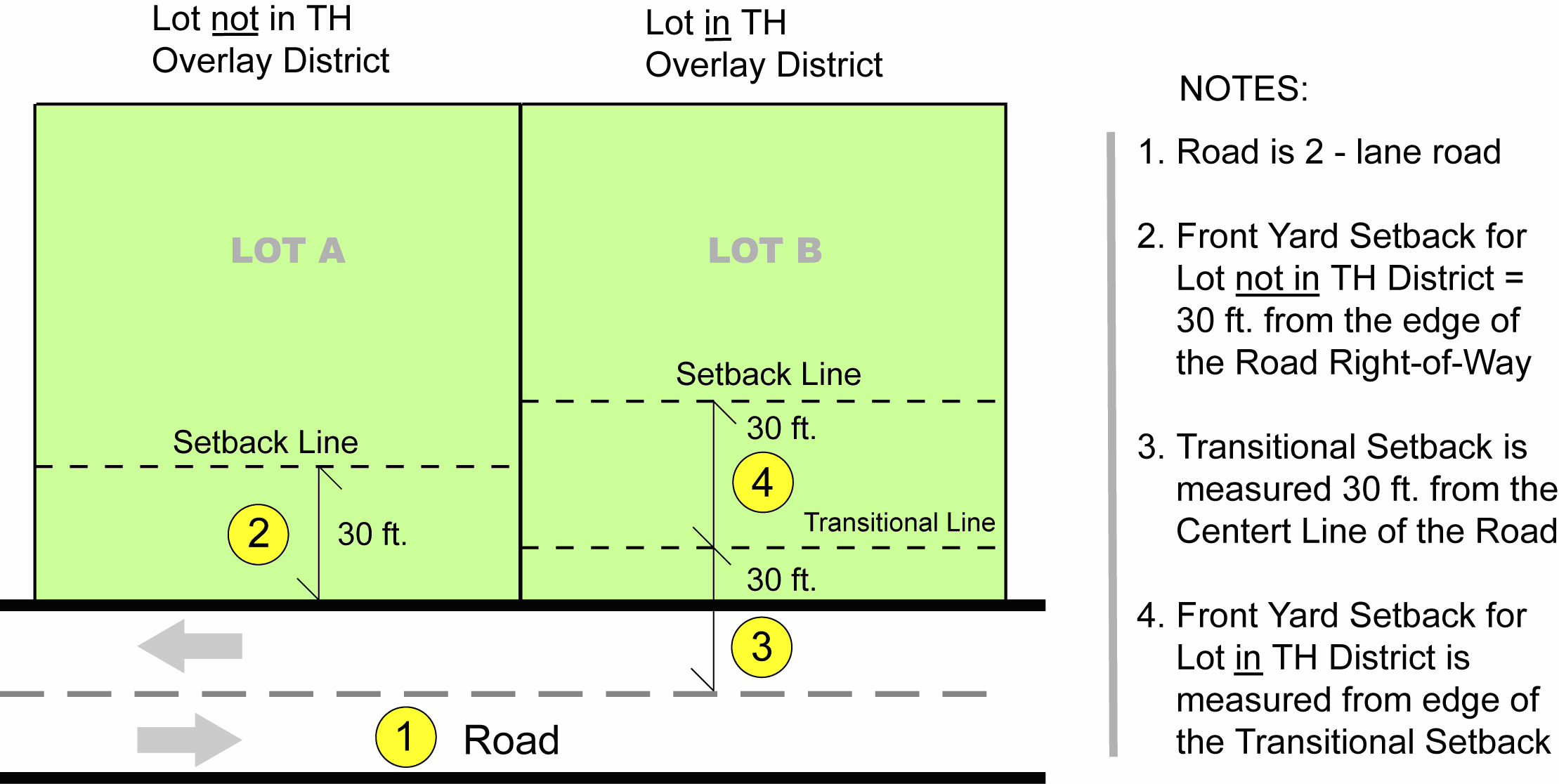
4.
The standards contained herein shall not apply to a development located on a lot in which such thoroughfare setback would normally be required which meets one or more of the following circumstances:
a.
A project that had a valid building permit in effect as of the effective date of implementation of this zoning district where such permit allows for construction or development to take place within the required thoroughfare setback.
b.
A project that had a site plan approved as of the effective date of the implementation of this zoning district where such site plan allows for construction or development to take place within the required thoroughfare setback.
c.
A project which had an approved and valid site specific or phased development plan in place as of the effective date of the implementation of this zoning district where such development plan allows for construction to take place within the required thoroughfare setback.
(Ord. No. 25-827, § 2, 3-4-25)
7.6.5 - USO URBAN STANDARDS OVERLAY DISTRICT
The Urban Standards Overlay (USO) district contains a number of design and subdivision standards that apply solely to non-residential uses on properties located in USO district (except where otherwise indicated):
A.
Parking Lot Connections.
(NOTE: These requirements shall also apply in the CH Overlay district)
(NOTE: The following provisions regarding parking lot connections shall NOT be applicable to lots in the CBD, I-1, I-2, I-3 or I-U zoning districts, irrespective of whether they are in the USO or CH Overlay Districts.)
(NOTE: The following provisions do not apply to temporary mobile classrooms approved on a designated school site for a period not to exceed two years)
Parking lots for commercial or office uses (but not for industrial uses) that lie in a Commercial or Office or TMU zoning district and which contain more than thirty-five (35) off-street parking spaces shall be designed to inter-connect with adjoining lots in such zoning districts. At least one future access point to such parking lot from an undeveloped adjoining lot shall be provided. The Administrator may require additional access points, when in their opinion, such additional access point would serve to benefit traffic flow and the safety of pedestrians and motorists using the street. The location of the access point shall be determined by the developer of the property in question and shall be subject to the Administrator's approval. The total number of required off-street parking spaces for all parking lots meeting the requirements of this section shall be reduced by three (3) parking spaces per access point for the lot being developed. The Administrator shall have the authority to waive or modify the requirements of this section upon finding that there is no practical way to create a shared driveway with an adjoining lot.
Figure 7.6.5-1 below illustrates how this requirement is to be implemented.
Figure 7.6.5-1
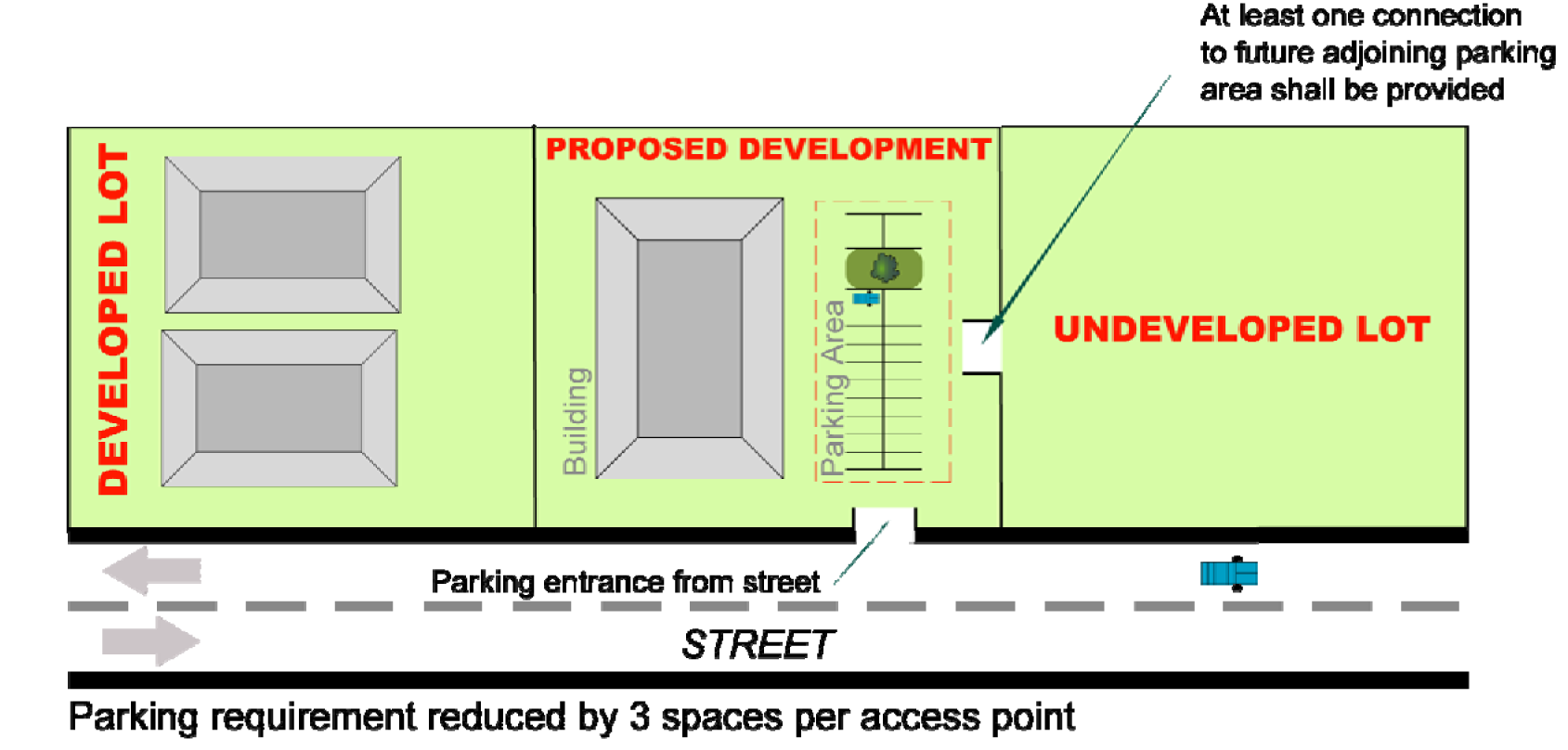
B.
Building Materials.
(NOTE: These regulations are also applicable in the CH and SH Overlay districts)
(NOTE: For existing structures that do not meet these standards, these regulations shall only apply when the square footage is increased by more than one hundred (100) percent).
(NOTE: These regulations do not apply to structures of seven hundred fifty (750) square feet and less.)
(NOTE: The following provisions do not apply to temporary mobile classrooms approved on a designated school site for a period not to exceed two years)
(NOTE: These regulations do not apply to new accessory structures on existing developed non-residential properties where the principal structure does not meet the standards of this section.)
1.
At least seventy-five (75) percent of the area below the fascia of any non-residential building face (excluding industrial uses) including doors and windows shall be finished with one or more of the materials designated as primary as listed below, with the remaining percentage consisting of any materials listed below subject to applicable building code requirements. (NOTE: The Administrator shall have the authority to approve building materials not specifically listed but similar in appearance and texture to those herein listed.)
a.
Brick, brick veneer or polystyrene faced with real brick veneers and field applied jointing. (Primary)
b.
Decorative CMU (concrete masonry unit) concrete block. (Primary)
c.
Pre-cast or field-poured tilt concrete panels with texture (such as exposed aggregate) and/or architectural detailing. (Primary)
d.
Stone, stone veneer, lath applied stone and cultured stone. (Primary)
e.
Flush architectural metal panels or other metal panels with architectural detailing, but not including sheet metal panels of "R" or similar corrugated and/or ribbed configuration or appearance. (Non-primary)
f.
Stucco with architectural detailing or artificial stucco (EPS/expanded polystyrene/"Drivet®") with architectural detailing. (Primary)
g.
Glass. (Primary)
h.
Doors, windows and other fenestration along with their casings. (Primary)
i.
Wood and wood materials designed and intended for use as exterior finish material. (Primary)
j.
Non-decorative CMU that is finished with a material which is similar in texture and appearance to an eligible primary building material as listed herein. (Primary)
2.
Trim and similar architectural detailing shall be composed of any code-approved materials (any material may be painted; however, paint and similar coatings themselves are not considered a finish material for the purpose of this list).
3.
Where visible from a public street or adjoining residential property, all facades of a building shall use materials consistent with those used on the front of the building and should be designed with similar detailing and be comparable in quality. Where not visible from a public street or adjacent residential property, facades shall consist of any combination of eligible primary or secondary materials or non-decorative CMU.
C.
Location of Off-Street Loading Areas.
Refer to Chapter 10 Off-Street Loading Areas.
D.
Building Colors.
(NOTE: The following provisions do not apply to temporary mobile classrooms approved on a designated school site for a period not to exceed two years)
1.
In addition to the building material standards contained in Subsection B, buildings within the Urban Standards Overlay District shall meet the following standards regarding building facade colors. Facade colors shall be of low reflectance earth tone, muted, subtle, or neutral colors. Building trim may feature brighter colors as an accent material. The use of high-intensity or metallic colors shall not be allowed except for accent purposes. The use of fluorescent, day glow, or neon colors shall be prohibited as a predominate wall color. Variations in color schemes are encouraged in order to articulate entryways and public amenities so as to give greater recognition to these features. Color samples shall be provided to the Administrator at the time of site plan review and prior to any renovations, remodelings, facelifts, and repainting, along with a description of how and where each color will be used. Colored renderings are encouraged, but shall not be a substitute for this requirement.
2.
This prohibition shall not apply to any wall or freestanding signage for the use.
E.
Building Articulation.
(NOTE: These provisions do not apply to industrial uses.)
(NOTE: For existing structures that do not meet these standards, these regulations shall only apply when the square footage is increased by more than one hundred (100) percent).
(NOTE: These regulations do not apply to structures of seven hundred fifty (750) square feet and less).
(NOTE: The following provisions do not apply to temporary mobile classrooms approved on a designated school site for a period not to exceed two years)
(NOTE: These regulations do not apply to new accessory structures on existing developed non-residential properties where the principal structure does not meet the standards of this section.)
1.
All building facades shall incorporate at least two (2) clearly evident horizontally-oriented architectural detail elements in order to break the vertical massing into smaller units.
2.
Building facades that are visible from public streets shall incorporate at least two (2) of the following design features:
a.
Display windows covering at least twenty-five (25) percent of the wall area.
b.
Distinctive architectural features such as a repeating pattern of wall offsets, pilasters, projections, columns or recesses varying from the plane of the wall by a minimum of one foot.
c.
At least three (3) different parapet heights which vary in appropriate proportions to the building wall and/or roof(s).
d.
Repetitive ornamentation including decorative applied features such as, but not limited to, wall mounted light fixtures or faux windows. Repetitive ornamentations shall be located with a maximum spacing of fifty (50) feet.
e.
Other elements that may be approved by the administrator.
3.
Where visible from a public street, roofs shall reflect a variation in planes, slope and/or features.
a.
Overhanging eaves shall extend past supporting walls.
b.
Flat roofs shall incorporate parapet walls with three-dimensional cornice treatments designed to conceal the roof and roof-mounted mechanical equipment.
c.
Roofs shall not have a shiny surface appearance similar to aluminized or galvanized metal; however, anodized or baked-on paint metal roofs shall be allowed.
F.
Entrance Orientation.
(NOTE: These provisions do not apply to industrial uses.)
(NOTE: The following provisions regarding entrance orientation shall be applicable ONLY within the UMU, TMU and CBD zoning districts.)
(NOTE: These provisions apply only to principal buildings constructed after the effective date of this Ordinance.)
(NOTE: The following provisions do not apply to temporary mobile classrooms approved on a designated school site for a period not to exceed two years)
(NOTE: These regulations do not apply to new accessory structures on existing developed non-residential properties where the principal structure does not meet the standards of this section.)
Any new principal building whose exterior facades face a public street, and constructed after the effective date of this Ordinance, shall install a pedestrian entryway opening onto at least one adjoining public street. Corner entrances shall comply with this requirement. Access from the adjoining public sidewalk, street right-of-way or driveway to the principal structure shall be provided through an improved surface.
G.
Rooftop and HVAC Equipment.
A parapet or an enclosure consisting of materials that meet the building material requirements of Subsection B herein shall conceal rooftop and HVAC equipment on all buildings visible from a public road, except I-85. This requirement shall not apply to any equipment required by to be located on the roof by either the State Building Code or the County Health Department. The Administrator shall have the authority to waive or modify this requirement based on site-specific conditions, including but not limited to: topography, lot size or site configuration that would make adherence to this requirement impractical.
H.
Sidewalks.
Refer to Section 9.18.1.
I.
Street Trees.
Refer to Section 11.4.
(Ord. No. 11-593, § 2, 8-2-11; Ord. No. 11-596, § 1, 10-4-11; Ord. No. 11-599, § 1, 12-20-11; Ord. No. 21-737, § 2, 5-18-21; Ord. No. 21-739, § 1, 6-15-21; Ord. No. 23-785, § 2, 4-18-23; Ord. No. 23-787, § 3, 6-20-23; Ord. No. 24-807, § 1, 4-16-24)
7.6.6 - GC GATEWAY CORRIDOR OVERLAY DISTRICT
A.
Permitted Uses.
Any permitted or special uses allowed in the underlying zoning district shall be permitted except as listed below. All new permitted and special uses shall meet all requirements as outlined in the Gateway corridor overlay. Where the requirements of the overlay are more restrictive than in the underlying district, the regulations of the overlay district shall prevail. Adult establishments shall be prohibited within the Gateway corridor overlay district, regardless of the underlying zoning designation.
1.
Uses prohibited in office districts:
a.
Bail bonding companies.
b.
Construction and property management offices.
c.
Communication towers are prohibited except as follows:
• Communication towers of any height are allowed subject to the same restrictions as applicable for residential districts outside the Gateway corridor overlay. This includes towers erected as an accessory use to a radio and television studio.
• Communication antennae may be placed on structures used primarily for other purposes in accordance with Section 9.15.
• Communication towers used for public safety communications or public emergency medical services communications, or any tower used for both public safety communications or public emergency medical services communications and private wireless telephone services, shall be allowed as of right.
2.
Uses prohibited in C-1, neighborhood commercial districts:
a.
Bail bonding companies.
b.
Construction and property management offices.
c.
Home electronic sales and repair.
d.
Appliance sales and repair.
e.
Auto service stations, convenience stores and mini-marts.
f.
Check cashing service.
g.
Taxi company.
h.
Communication towers are prohibited except as follows:
• Communication towers of any height are allowed subject to the same restrictions as applicable for residential districts outside the Gateway corridor overlay. This includes towers erected as an accessory use to a radio and television studio.
• Communication antennae may be placed on structures used primarily for other purposes in accordance with Section 9.15.
• Communication towers used for public safety communications or public emergency medical services communications, or any tower used for both public safety communications or public emergency medical services communications and private wireless telephone services, shall be allowed as of right.
3.
Uses prohibited in C-2, highway commercial districts:
a.
Automotive engine and drive train repair, body shops, wrecker storage facilities, and junk and salvage yards, and other auto uses involving outdoor storage.
b.
Game rooms.
c.
Golf driving ranges and miniature golf.
d.
Flea markets.
e.
Self service and automatic car washes.
f.
Taxi company.
g.
Communication towers are prohibited except as follows:
• Communication towers of any height are allowed subject to the same restrictions as applicable for residential districts outside the Gateway corridor overlay. This includes towers erected as an accessory use to a radio and television studio.
• Communication antennae may be placed on structures used primarily for other purposes in accordance with Section 9.15.
• Communication towers used for public safety communications or public emergency medical services communications, or any tower used for both public safety communications or public emergency medical services communications and private wireless telephone services, shall be allowed as of right.
4.
Uses prohibited in C-3, general commercial districts:
a.
Storage warehouses and yards.
b.
Sales and service of manufactured homes; farm, construction and excavation machinery, trucks and implements; trucks; automobiles; and recreational vehicles; and the sale only (excluding service and repair) of automobiles.
c.
Veterinary hospitals with outside runs and commercial kennels.
d.
Automobile car washing facilities.
e.
Miniwarehouses.
f.
Freestanding recycling collection points.
g.
Recreational courses for minibikes, small motor powered cars and similar recreational vehicles.
h.
Communication towers are prohibited except as follows:
• Communication towers of any height are allowed subject to the same restrictions as applicable for residential districts outside the Gateway corridor overlay. This includes towers erected as an accessory use to a radio and television studio.
• Communication antennae may be placed on structures used primarily for other purposes in accordance with Section 9.15.
• Communication towers used for public safety communications or public emergency medical services communications, or any tower used for both public safety communications or public emergency medical services communications and private wireless telephone services, shall be allowed as of right.
5.
Uses prohibited in industrial districts:
a.
Outdoor storage yards visible from the affected urban corridor as accessory or principal uses.
b.
Storage building sales and display.
(Ord. No. 11-593, § 2, 8-2-11; Ord. No. 21-739, § 1, 6-15-21)
7.6.7 - RESERVED
Editor's note— Ord. No. 16-646, § 1, adopted May 17, 2016, repealed § 7.6.7, which pertained to center city design overlay district and derived from Ord. No. 14-632, § 6, adopted August 19, 2014.
SECTION 7.7 - ORIENTATION OF SINGLE-FAMILY AND MANUFACTURED HOMES IN RESIDENTIAL ZONING DISTRICTS
In any single-family residential zoning district (R-1, R-1S, R-2, R-3, and R-4), any single-family dwelling moved onto the lot, modular dwelling or manufactured home shall be situated on the lot so that the external wall which, by design, is intended to be the front, generally faces a street adjoining the lot. This requirement shall not apply in either of the following situations:
(1)
The dwelling is located on a "flag" or "panhandle" lot; or
(2)
The dwelling is set back at least one hundred (100) feet from the street right-of-way on an interior lot.
Relief to this requirement may be granted by the Planning Commission subject to the following findings:
(1)
The dwelling cannot practically be located on the subject lot in any other manner; and,
(2)
The dwelling shall have sufficient architectural treatment so that the end wall does not appear to be an end wall.
SECTION 7.8 - HEIGHT CALCULATIONS AND EXCEPTIONS
For purposes of this Chapter, the height of a structure shall be the vertical distance measured from the mean elevation of the finished grade at the front of the structure to the highest point of the structure, except as provided herein. The maximum heights indicated in the various zoning districts may be exceeded for the following uses:
• Roof structures not intended for human occupancy and serving in an accessory capacity to the principal structure on the lot, such as skylights, housing for elevators, stairways, water tanks, ventilating fans, air conditioning equipment or similar equipment, steeples, spires, belfries, and cupolas or chimneys, and radio and television antennae (excluding communication towers) may exceed the maximum allowable heights as provided in any of the zoning districts. The height of communication towers, as a principal or accessory use, shall be governed per Section 9.15.
• Any structure which exceeds the prescribed maximum building height for the zoning district in which it is located by more than ten (10) feet shall be located on the lot so that no portion of the structure is located closer to any lot line than the greater of: (1) the minimum setback regulations in that zoning district or, (2) the difference between the actual height of the structure and the normally allowed maximum building height in that zoning district.
For all other structures in excess of thirty-five (35) feet in height which are (i) located in any zoning district except the CBD and, (ii) which abut any Residential district, the minimum side yard shall be increased one foot for each one foot of building height in excess of thirty-five (35) feet.
A parapet wall or cornice may extend up to five (5) feet above the maximum building height for the zoning district in question without necessitating any greater setback requirement.
SECTION 7.9 - CONVERSION OF RESIDENTIAL STRUCTURES TO NON-RESIDENTIAL USES OR MIXED-USE DWELLING
In any non-residential zoning district, a residential structure that existed on or before the date of adoption of this Ordinance, may be converted to a permitted nonresidential use (or a mixed-use dwelling), so long as all applicable off-street parking and landscaping requirements are met. If such use is a conditional use, the Planning Commission or City Council may attach fair and reasonable conditions which would serve to mitigate any existing nonconforming situations arising from such conversion.
7.10.1 - INTRODUCTION
Per G.S. 136-66.10, dedication of right-of-way in conformance with the locally adopted transportation plan is required for subdivisions of land which are located in areas where thoroughfare improvements are proposed. Should such a dedication be required in association with a plat approval, density credits may be used, in a manner as provided herein, on the remaining portions of the tract(s) in question. The granting of such density credits shall be made by the City Council. The application of density credits shall not affect whether a use, per se, is allowed or not on that lot. Such use shall remain governed by the list of permitted (and, if applicable, conditional) uses for that particular zoning district as listed elsewhere in this Ordinance.
7.10.2 - DEFINITIONS
The following terms are to be used in computing and applying density credits:
7.10.3 - RIGHT-OF-WAY DEDICATION
Per G.S. 136-66.10, the City Council may grant density credits whenever right-of-way dedication, in accordance with the thoroughfare plan, is required for a tract of land located within the planning jurisdiction of the City, and such tract is proposed for subdivision or use of land pursuant to a zoning permit.
Right-of-way dedication may be so required by the governing board where a subdivision, as herein defined, occurs, or in situations where land subdivision is not involved, when the governing board determines that:
a.
Said dedication does not result in the deprivation of all reasonable use of the original tract; and
b.
The dedication is reasonably related to the traffic generated by the proposed use of land, or the impact of dedication is mitigated by other measures including the use of density credits, as herein prescribed, on contiguous land owned by the subdivider.
If the full width of the thoroughfare for which land is to be dedicated is completely contained within the tract of land to be used or developed, up to one hundred (100) percent of the right-of-way needed to construct or enlarge the thoroughfare on that tract shall be provided. If a portion of such thoroughfare is located on the property proposed to be subdivided or developed, the corresponding proportion of land on that tract may be required to be developed.
Dedication of land, as provided herein, shall be offered to the public. Proof, in the form of an instrument having been recorded in the Register of Deeds office, of such dedication having been made shall be furnished to the Administrator prior to the issuance of any zoning permit that incorporates the use of density credits.
Any land so dedicated shall substantially be that as needed for the thoroughfare right-of-way in question as shown on the thoroughfare plan.
7.10.4 - DENSITY CREDIT FORMULAE
The following formulae shall be used in applying density credit bonuses:
A.
Single-Family Including Lots Containing Individual Manufactured Homes) and Two-Family Lots.
The density credit bonus is derived by dividing the area dedicated for thoroughfare purposes (A1) or (A2) by the area of the entire tract and then multiplied by one hundred (100) (A1 or A2/B × 100). The resulting figure may be used on a percentage-by-percentage basis to reduce minimum lot sizes up to a maximum of twenty-five (25) percent.
B.
Multi-family Developments and all Other Developments Where Density is Measured on a Unit-per-Acre Basis.
The density credit bonus (A1 or A2/B) shall be multiplied by the maximum density level ("F") in the underlying zoning district. The resulting figure is then added to "F" and then multiplied by "C," the remaining developable land in the tract once the right-of-way dedication has been made. In no case may the subsequent density level be raised by more than twenty-five (25) percent over that level which is normally allowed in the underlying zoning district. Irrespective of the use of density credits, all yard, height, parking, and setback requirements as stated in this Chapter are to be observed.
C.
Other Nonresidential Developments.
The area to be computed for the density credit shall be determined (A1 or A2) and shall be divided by three hundred thirty (330) square feet. The resulting figure shall represent the maximum reduction in the number of required off-street parking spaces to be provided. In no case may this reduction constitute greater than ten (10) percent of the required number of off-street parking spaces.
7.10.5 - ZONING MAP NOTATION
All properties that have received governing board approval for the usage of density credits shall be so noted in the zoning map.
7.10.6 - ISSUANCE OF ZONING PERMIT
A zoning permit may not be issued for development on a lot that has been awarded density credits, if such development is contingent upon the use of such density credits, until proof is documented that the associated right-of-way dedication to the public has been made.
SECTION 7.11 - CENTRAL BUSINESS DISTRICT DESIGN STANDARDS
A.
Purpose. The purpose of the Central Business District (CBD) design standards is to ensure that development which takes place in the Central Business District is executed with appropriate urban design, site planning and architectural principles and techniques. A goal of these standards is to promote a stable, attractive, economically viable, pedestrian-scaled environment in the downtown area of Gastonia. The City Council finds that the downtown area and its immediate environs is very important to the economic and social well-being of the city, and further desires to provide protections to property owners who invest in the downtown area from the negative impacts of development that is inharmonious with the unique environment of the historic downtown. To accomplish the goals stated herein, architectural standards, site layout, building materials, and sign standards are specified to insure high quality design. Where there is conflict with other portions of the ordinance in terms of allowed uses, yard and height requirements, parking and landscaping standards, etc., the requirements herein prevail, whether more or less restrictive.
B.
Design Review Required. Unless otherwise provided in this Ordinance, no exterior portion of any building or other structure (including but not limited to masonry walls, fences, light fixtures, satellite dish signal transmission equipment, steps and pavement, or other appurtenant features) nor aboveground utility structures within the CBD shall be erected, altered or moved until an Application for Design Review (Application) has been submitted to and approved by a Design Review Committee (DRC) to review and approve such applications. The DRC shall be a committee comprised of City staff, appointed by the City Manager.
Application approval is required prior to the issuance of a building permit or other permit granted for the purposes of constructing, altering, moving or demolishing structures, which approval may be issued subject to reasonable conditions necessary to carry out the purposes of this section. An approved application shall be required whether or not a building permit is required, but said approval does not obviate the necessity of procuring a building permit or such other permit as may be required by law; provided, however, any building permit or other permit issued other than in conformity with this Chapter shall be invalid.
1.
Submission of application. An application for design review shall be complete and include all information as described in this section. Applications must be signed by the owner of the subject property or their agent. Such application must be accompanied by sketches, drawings, photographs, specifications, descriptions, etc. of the proposed project sufficient to inform the DRC of the nature and extent of the application. An application shall not be deemed complete until all the required information shall have been submitted. Nothing shall prevent the applicant from filing with the application additional relevant information bearing on the application. Properly completed applications shall be filed with the Planning Department who shall forward such applications to the DRC. The DRC will complete the review process and issue its decision with thirty (30) days of submittal.
2.
Appeal of decision. An appeal of any decision of the DRC may be taken to the Board of Adjustment. Any appeal from the decision of the Board of Adjustment in any such case shall be heard by the Superior Court of Gaston County in accordance with this Ordinance.
3.
Compliance required. Compliance with the terms of the DRC's written decision shall be enforced by the zoning administrator or their designee. Failure to comply shall constitute a violation of this Ordinance. Design review approval shall remain in effect until its terms and conditions are completed; provided, discontinuance of work or the lack of progress toward achieving compliance with the approval for a period of six (6) months shall be deemed a failure to comply with the approved application.
C.
Architectural Standards and Design Criteria. The DRC shall review the application for compliance with the design standards established herein (Section 7.11).
D.
Central Business District Design Review Area DRC recommendation on Conditional Use Applications. When a site plan is required to be submitted with a conditional use application regarding property in the CBD, the site plan shall be reviewed by the DRC prior to presentation to the Planning Commission and City Council. This review shall be limited to exterior features, as set forth in the applicable standards as set forth herein. The DRC may make recommendations regarding the exterior features of the site and shall forward such comments within thirty (30) days of the filing of the complete conditional use application. The comments shall be presented to the Planning Commission and City Council.
E.
Land Use Considerations. All uses listed in Section 7.1-1 for the CBD are retained, with the following exceptions.
1.
Restaurant, fast food. Permitted in the district provided that no drive-through service shall be allowed except in instances where properties have frontage on at least two (2) major thoroughfares as designated in the most recently adopted version of the thoroughfare plan of the Gaston Urban Area. In those instances where drive-thru service is permitted, the vehicle stacking area for the drive-thru service area shall not be subject to the minimum standards established elsewhere in this Ordinance. Any fast food that includes a drive-thru shall also include outdoor dining areas and on-site bike racks. The DRC, as part of its review of a proposed fast food with a drive-thru, may require certain additional site improvements and architectural standards be met in addition to ordinance minimums. These include, but are not limited to: alternate paving treatments for pedestrian and vehicular traffic areas, roof extensions to cover drive-thru service windows, and menu board dimensional and material specifications including lighting. In addition, no high intensity colors (such as yellow, red, orange, etc.) metallic colors, or fluorescent colors shall be allowed on any building or architectural element. The use of such colors shall be permitted on business identification signs, provided all other sign requirements herein are adhered to. Furthermore, the use of "franchise architecture" shall not be allowed. For purposes of this section franchise architecture shall be defined as a distinct architectural building style and/or elements commonly employed by a fast food franchise that serves to enhance or promote brand identity through visual recognition. This type of architecture has been shown to contribute to the dilution of a unique community identity. Finally, any children's play area provided by the restaurant may not be located in the front or side yard of any lot. As with all other new and renovated sites and buildings within the CBD, these uses shall be subject to review by the DRC and must meet all site and design standards established for the CBD.
2.
Dwelling units. While residential use above the street level is encouraged, residential use at the street level is generally discouraged (whether it be conversion of existing nonresidential space or new construction), as residential at the street level in the core retail/arts/entertainment area does not provide adequate street-level activity to contribute to pedestrian and urban vitality. However, for areas in the CBD outside the core retail/arts/entertainment area, street-level residential may be allowed subject to approval by the DRC. This allowance includes locations where existing street-level residential may be expanded and also the potential for ground-floor residential located internal to a block (no street frontage). Single-family and two-family detached residential dwelling units shall not be allowed anywhere in the district, regardless of size. Residential dwelling units may be provided on the second or higher floor of any building containing commercial uses, non-profit organizations, or office-type uses on the ground floor, provided each unit meets or exceeds all applicable fire safety and minimum housing and/or building codes.
a.
When located internal to a block (not fronting a public street) and when more than one building is proposed, all buildings shall be oriented parallel toward either a public street, or an interior courtyard. All buildings shall be separated from one another by at least sixteen (16) feet.
b.
Minimum driveway widths shall be twelve (12) feet for one-way drives, and twenty (20) feet for two-way drives.
3.
Bail bonding offices. Office uses within the CBD shall not include bail bonding offices.
F.
Sign Consideration, Required. See Section 12.10, Signs permitted in the central business district.
G.
General Design Standards.
Unless otherwise noted, these requirements shall apply to all new and renovated buildings within the CBD constructed after the date of passage of these standards. All modifications or changes to the design or materials of existing buildings shall be in conformance with the standards herein. These building design standards do not mandate a particular style and permit a wide variety of architectural expressions. However, when a design exhibits a known architectural style (i.e. Colonial, Victorian, Classical Revival) the details shall be consistent with that style.
1.
Proportion: A buildings' mass and scale shall be visually compatible with the buildings, structures and places to which it is related.
a.
Smaller scale buildings and the use of traditionally sized building components help to establish human scale and maintain the character of downtown. Standard size brick, uniform building components, and standard window sizes are most appropriate.
b.
Floor-to-floor heights should appear to be similar to those seen traditionally. In particular, the windows in a building should appear similar in height to those seen traditionally.
c.
Design of buildings should clearly define a base, middle and top.
d.
Buildings should be divided into "modules" that are similar in scale to buildings seen traditionally. If a larger building is divided into "modules," they should be expressed three-dimensionally throughout the entire building facade.
e.
Building wall offsets, including projections and recesses add architectural interest and variety; relieve the visual effect of a single, long wall; and subdivide the wall into human size proportions.
2.
Openings: The relationship of the placement, dimensions and characteristics of the windows and doors in the building shall be visually compatible with buildings, structures and places to which it is related.
a.
Buildings shall be required to maintain a functional public entrance on one or more public streets with a public sidewalk. A public or private parking lot shall not be construed to be a public street for purposes of this section.
b.
The rhythm of recessed entrances on the street contributes to visual continuity and historic character. Recessed entries identify the entrance and provide shelter, while corner entries on buildings located on the intersections of key streets draw pedestrians inside.
c.
Entryways shall have a strong design that is consistent with the architecture of the rest of the building. Elements of strong entryway design include canopies, awnings, porticos, arcades, raised cornice parapets over the door, peaked roof forms, arches or other architectural details such as tile work and mouldings that are integrated into the building structure and design.
d.
Entry doors along public streets should be constructed of and framed with wood, or finished metal. Such doors should have glass panes to allow light and visibility. Unfinished metal frames should be avoided. Metal security doors are acceptable for entrances not readily visible from a street or public activity area.
e.
For new and existing buildings, no openings on any portion of a wall oriented toward a public street shall be covered or blocked with any material so as to render the opening functionally obsolete. Furthermore, no security bars, or panels, whether retractable or permanent, shall be constructed, erected, or utilized on the exterior portion of any building wall oriented toward a public street.
f.
All windows should be framed with wood, or finished metal. Windows with true-divided panes are encouraged, however, if snap-in mullions are used, they should be attached to the outside of the glass in order to provide a shadow line. Internal mullions and vinyl-clad windows should be avoided.
g.
Window openings should be framed with wood or brick sills, and an exposed header, head molding or lintel course of masonry.
3.
Patterns: The relationships of elements in a façade of a building or structure shall be visually compatible with buildings, structures and places to which it is related.
a.
Maintain the rhythm of facade widths, especially for projects that extend over several lots, by changing materials, patterns, reveals, building setbacks, facade portions, or by using design elements such as columns or pilasters.
b.
Develop the first floor facade as primarily transparent, making it inviting to the public. Use windows and other architectural features to create a pattern that will reinforce the traditional facade rhythm found on historic buildings in the downtown area. Upper floors generally are differentiated through the use of more solid areas than voids and with smaller, though still vertically oriented, windows in a regular pattern.
c.
Honor the alignment of architectural features with other buildings on the block. These lines unify the street visually. The alignment of architectural features, from one building to the next, creates visual continuity and establishes a coherent visual context throughout the downtown and create patterns along the face of the block that contribute to the overall character of the area. Some facade elements that typically align with adjoining buildings include:
• Parapet and cornice line
• Building kickplate
• The top and bottom height of first floor display windows
• Transom over the entranceway
• Clerestory portion of display windows
• Horizontal and vertical proportions of the building
• Storefront and restaurant front windows
• Window openings and styles, especially upper story windows
• Sign band above the street level
• Window sills on upper floors
• Roof lines and proportions
4.
Spacing: The relationship of a building to the open areas between it and the adjoining buildings shall be visually compatible with the buildings, structures and places to which it is related.
a.
Through-block connections can be used in large projects to promote pedestrian circulation throughout the downtown. Design such connections to be interesting places, not merely hallways to parking lots or alley service loading areas. They shall be handicap accessible, well lighted, appropriately landscaped, and paved in materials compatible with their locations and surrounding context. Opportunities for artwork or other visual innovations are encouraged.
b.
Locate sidewalk restaurants or outdoor dining areas on or adjacent to open spaces and pedestrian routes such as sidewalks and green areas. Connect shops or office entrances directly to places where people gather or walk. Where appropriate and allowable, the use of well designed and shielded rooftop decks for restaurants and access to views is encouraged.
c.
When possible, orient open spaces (plazas, courtyards, pocket parks, terraces, etc) to the sun and important views or vistas. Create a sense of enclosure while maintaining safety, so that open spaces feel like outdoor rooms.
5.
Presence: The projection, supports, height and relationship to streets and sidewalks, of awnings, canopies and balconies of a building shall be visually compatible to the buildings, structures and places to which it is related.
a.
Buildings or other design features that are built up to the sidewalk maintain a line of visual continuity and provide visual interest for pedestrians. If a portion of the building façade is set back from the sidewalk, the sidewalk edge shall be visually maintained through the use of a line of columns supporting upper floors or other features, such as a change in surface texture, a line of planters, portals, or railings.
b.
Awnings should be designed to fit the storefront opening to emphasize the building's proportions. Awnings should not obscure or damage important architectural details. Align awnings with others on the block.
c.
Awnings should be canvass. Mansard style wood awnings, awnings with roof shingles, and all metal awnings should be avoided, with the exception of copper- or bronze-clad awnings.
d.
Awnings, canopies and hanging signs shall be allowed to protrude a maximum of five (5) feet from the building face over a public sidewalk, provided that the bottom edge of the awning or sign leaves at least eight (8) feet of vertical clearance from the sidewalk; and provided that the awning or sign comes no closer than two (2) feet to the street pavement. Entryway canopies shall not be subject to the five-foot limit described herein; but all other rules shall apply.
6.
Materials, Textures and Colors: The materials, textures and colors of the façade of a building shall be visually compatible with the predominant materials, textures and colors used in the buildings and structures to which they are related.
a.
Brick has historically been the predominant building material used in the downtown, therefore, the use of brick as the primary building material is strongly encouraged.
b.
Acceptable primary building materials include:
• Brick
• Brick veneer
• Stone or simulated stone/marble
• Ornamental split-faced concrete block or similar ornamental concrete masonry unit (CMU)
• Lightly textured stucco (synthetic or natural)
c.
Choose accent materials similar in texture and scale to others in the district. Appropriate accent materials include:
• Brick and stone masonry
• Wood details such as windows
• Finished lumber, applied to achieve traditional patterns e.g.: horizontal siding rather than diagonal
• Finished painted metal
• Clear or lightly tinted glass
• Ceramic tiles
• Brick, clay and ceramic pavers
• Slate, finished metal, glazed ceramic and tile roofs
• Concrete and stone as lintels and wood or concrete columns
• Embossed metal or corrugated metal
• Cast or wrought iron
• Quoins are encouraged to frame building edges
d.
Materials specifically disallowed as primary siding materials include (but may not be limited to):
• Vinyl siding
• Unfinished wood
• Concrete block (except split-faced block)
• Heavily textured stucco
• Metal siding, metal cladding, and/or metal architectural panels shall be prohibited within the district for use on the exterior of new or existing buildings. Ornamental metal trim work (i.e., copper sheathing, brass, wrought iron, etc.) and/or architectural details shall be allowed provided the cumulative area of such materials does not exceed fifteen (15) percent of the total square footage of the wall onto which it is affixed
e.
No high intensity colors (such as yellow, red, orange, etc.) metallic colors, or fluorescent colors shall be allowed on any building or architectural element.
f.
In specific and exceptional circumstances (such as LEED standards), where the design review committee finds that the spirit and intent of the ordinance are clearly met with the use of other materials, textures and colors than are listed herein, certain other alternate utilizations of these items may be approved by the DRC.
7.
Roofs: The roof shape and materials of a building shall be visually compatible with the buildings and structures to which it is related.
a.
The predominant roof form in downtown is a flat roof with a raised parapet and decorative cornice. This roof form is appropriate in nearly all areas of the CBD.
b.
The use of pitched roof is generally discouraged, except when the building is geographically isolated from nearby construction or when there is a strong visual connection with an existing building or structure with a pitched roof.
c.
Roof materials should not be of the type that harshly reflects sunlight, causing glare.
8.
Historic Building Rehabilitation or Expansion: Projects involving the rehabilitation or expansion of downtown historic buildings should reflect the original architectural character of the building.
a.
Introduction of new design elements should be consistent with the traditional features of the building.
b.
It is encouraged that all projects involving rehabilitation or expansion of historic buildings be consistent with the Secretary of Interior's Standards for Rehabilitation to the greatest extent practicable.
c.
It is not the intention of these design guidelines to recreate the past if an original building facade does not exist. However, if the original facade does not exist, but documentary evidence such as photographs of the original does exist, then one recommended alternative is to restore the facade. Where exact reconstruction is not practical, new simplified contemporary interpretations of the original details are possible as long as the scale and character of the original detail is retained.
9.
Accessory Features: All dumpster enclosures, walkways, stairways, landings or other significant accessory features shall be visually compatible with buildings and structures to which they are related.
a.
Pedestrian routes in structures and lots shall be easily identifiable and accessed. Clear visual connections between a garage, or surface parking lot, and adjacent sidewalks and buildings are required. Interior and exterior lighting should be designed for safety as well as nighttime appearance.
b.
Elements such as trash collection areas shall be screened, designed as an integral part of the overall building design, and present an attractive feature when viewed from adjacent areas.
H.
Site Considerations, Required.
1.
At least forty (40) percent of the front facade length of any new building shall be set back not more than eight (8) feet from the front property line; however, in no case shall any building be sited closer than ten (10) feet to the back of existing curb. On corner lots, the wall fronting the side road and considered to be a "side wall" of the building may be set back not more than twelve (12) feet from the corner side property line.
2.
There is no parking requirement for residential uses in the CBD. Any parking voluntarily provided shall be placed in the side and rear yards.
3.
For buildings on corner lots, on-site parking may be provided only in the interior side yard or rear yard.
4.
Any off-street parking spaces provided in the CBD shall be a minimum of eight and one-half (8½) feet in width and sixteen (16) feet in length.
5.
Any above-grade parking structures must have leasable retail or service space(s) on the ground floor, for the entire length of the facade abutting or within twenty (20) feet of any public street(s) except where ingress and egress drives are provided. The facade treatments for the leasable space(s) shall be subject to the same design requirements detailed herein.
6.
All parking lots adjoining a public street shall be screened from the view of any public street in one of the following three (3) ways, or a combination of any:
a.
With a wall constructed of masonry, ornamental split-face block, or concrete block covered with stucco or synthetic stucco, between three (3) and six (6) feet in height. Any portion of such a wall above three (3) feet in height above grade shall be at least sixty (60) percent open. In addition there shall be masonry piers providing a visual break in the wall, and placed at increments of not less than one for each twelve (12) feet of wall length, and one on any corner of such a wall. Where there are driveway openings in the wall, the height shall be reduced to not more than three (3) feet for the first twelve (12) feet on either side of the driveway. Street trees otherwise required by this subsection (i) shall not be required under this provision.
b.
Masonry piers at intervals of between eight (8) and twelve (12) feet, supporting vertically oriented wrought-iron or aluminum fencing panels. The height of this design shall be between four (4) and six (6) feet. Aluminum fencing panels shall have a medium or dark finish. Street trees otherwise required by this subsection (i) shall not be required under this provision.
c.
A masonry wall, ornamental split-face block wall, or concrete block wall covered with stucco or synthetic stucco, three (3) feet in height above grade, and with a landscaped strip immediately behind the wall planted with street trees and shrubs.
7.
All new fences in the CBD shall be constructed of brick, stone, stucco or other decorative masonry finish. Fences with columns constructed of brick, stone, stucco or other decorative masonry finish used in combination with wrought-iron (or brushed aluminum or anodized aluminum that mimic the style and appearance of wrought iron) pickets shall also be acceptable. For fences installed to meet the requirements for parking lot screening, the specific standards set forth in Section 7.11(h)(5) shall apply.
Picket fences (constructed with either wood or vinyl pickets) and vinyl-coated chain link fences are allowed subject to the following: (1) they do not exceed six (6) feet in height; (2) they are shielded from view from all adjoining streets, parking areas (including drive aisles) and activity areas such as courtyards and pedestrian walkways; (3) they are not closer than seventy-five (75) feet to a public street right-of-way; (4) temporary chain link fencing for construction or demolition is allowed with an active building or demolition permit. Temporary chain link fences may also be permitted by the Zoning Administrator for up to six (6) months (and renewable up to two (2) times) when he deems it necessary to protect the public from unexpected temporary structural dangers, such as building collapse.
I.
Approval of Alternate Designs. In order to allow for flexibility in the design of buildings and site construction and renovation, while at the same time substantially satisfying the purpose and intent of this section, the Design Review Committee may approve certain alternate designs which may not meet the strict requirements of this section but clearly satisfy its purpose and intent. No request for alternate design shall be considered unless an application has been filed with the Planning Department on forms provided by the department and accompanied by plans or drawings as may be specified on such forms. The Design Review Committee may approve such alternate design only upon making all of the following findings in the affirmative:
1.
The proposed design substantially meets the requirements of this section.
2.
The proposed design is in harmony with the general purpose and intent of this section and preserves its spirit.
3.
The public interest achieved by this section will be served at least equally by allowing the alternate design as opposed to not allowing such alternate design.
4.
The granting of the alternate design will not endanger the public health or safety if approved; and, that it will not substantially injure the value of adjoining properties or other properties within the downtown area.
5.
The applicant has submitted reasons justifying the need for the alternate design and that such need results from the strict application of this section. Building codes, or other law as opposed to reasons not resulting from the ordinance or law such as personal hardship, economic hardship, or violation of this section.
Upon making all such findings in the affirmative the director shall send notice that, unless an appeal to the Board of Adjustment is filed, the alternate design will take effect within fifteen (15) days of said notice. Said notice shall be sent, by hand delivery or first class mail, to all adjoining property owners, the City Manager, and any other persons who have filed with the Planning Department, a request to be notified of any alternated designs approved under this section. If the DRC fails to find all five (5) findings in the affirmative, the director shall send notice along with reason(s) for denial by hand-delivery or certified mail to the applicant. The notice shall state that the applicant shall have up to thirty (30) days from the date the notice is received to file an appeal to the Board of Adjustment.
The Board of Adjustment shall conduct a public hearing on such appeal after having provided public notice in accordance with this Ordinance. The Board of Adjustment may grant the request for an alternate design only after having made all five (5) findings set forth in this section. The decision of the Board of Adjustment is appealable only to the Superior Court by writ of certiorari.
(Ord. No. 11-586, § 4, 1-18-11; Ord. No. 22-774, 10-18-22; Ord. No. 21-739, § 1, 6-15-21)
SECTION 7.12 - URBAN MIXED USE DESIGN STANDARDS
A.
Purpose. The purpose of the Urban Mixed Use District (UMU) design standards is to ensure that development which takes place in the Urban Mixed Use district is executed with the appropriate urban design, site planning and architectural principles and techniques. A goal of these standards is to promote a stable, attractive, economically viable, pedestrian-scaled environment. The City Council finds that the downtown and surrounding areas are very important to the economic and social well-being of the city, and further desires to provide protections to property owners who invest in those areas from the negative impacts of development that is inharmonious with the unique environment of the Urban Mixed Use district. To accomplish the goals stated herein, architectural standards, site layout, building materials, and sign standards are specified to ensure high quality design. Where there is conflict with other portions of the ordinance in terms of allowed uses, yard and height requirements, parking and landscaping standards, etc., the requirements herein prevail, whether more or less restrictive.
B.
Design Review Required. Unless otherwise provided in this Ordinance, no exterior portion of any building or other structure (including but not limited to masonry walls, fences, light fixtures, satellite dish signal transmission equipment, steps and pavement, or other appurtenant features) nor aboveground utility structures within the UMU shall be erected, altered or moved until an Application for Design Review (Application) has been submitted to and approved by a Design Review Committee (DRC) to review and approve such applications. The DRC shall be a committee comprised of City staff, appointed by the City Manager.
Application approval is required prior to the issuance of a building permit or other permit granted for the purposes of constructing, altering, moving or demolishing structures, which approval may be issued subject to reasonable conditions necessary to carry out the purposes of this section. An approved application shall be required whether or not a building permit is required, but said approval does not obviate the necessity of procuring a building permit or such other permit as may be required by law; provided, however, any building permit or other permit issued other than in conformity with this Chapter shall be invalid.
1.
Submission of Application. An application for design review shall be complete and include all information as described in this section. Applications must be signed by the owner of the subject property or their agent. Such application must be accompanied by sketches, drawings, photographs, specifications, descriptions, etc. of the proposed project sufficient to inform the DRC of the nature and extent of the application. An application shall not be deemed complete until all the required information shall have been submitted. Nothing shall prevent the applicant from filing with the application additional relevant information bearing on the application. Properly completed applications shall be filed with the Planning Department who shall forward such applications to the DRC. The DRC will complete the review process and issue its decision with thirty (30) days of submittal.
2.
Appeal of Decision. An appeal of any decision of the DRC may be taken to the Board of Adjustment. Any appeal from the decision of the Board of Adjustment in any such case shall be heard by the Superior Court of Gaston County in accordance with this Ordinance.
3.
Compliance Required. Compliance with the terms of the DRC's written decision shall be enforced by the zoning administrator or their designee. Failure to comply shall constitute a violation of this Ordinance. Design review approval shall remain in effect until its terms and conditions are completed; provided, discontinuance of work or the lack of progress toward achieving compliance with the approval for a period of six (6) months shall be deemed a failure to comply with the approved application.
C.
Urban Mixed Use District Design Review Area DRC Recommendation on Conditional Use Applications. When a site plan is required to be submitted with a conditional use application regarding property in the UMU, the site plan shall be reviewed by the DRC prior to presentation to the Planning Commission and City Council. This review shall be limited to exterior features, as set forth in the applicable standards as set forth herein. The DRC may make recommendations regarding the exterior features of the site and shall forward such comments within thirty (30) days of the filing of the complete conditional use application. The comments shall be presented to the Planning Commission and City Council.
D.
Land Use Considerations. All uses listed in Section 7.1-1 for the UMU are retained, with the following exceptions.
1.
Restaurant, with Drive Thru. The use shall be subject to the off-street staging space requirements of Chapter 10. Any Restaurant, with Drive Thru shall also include an outdoor dining area and on-site bike racks. The DRC, as part of its review of a proposed Restaurant, with Drive Thru, may require certain additional site improvements and architectural standards be met in addition to ordinance minimums. These include, but are not limited to: alternate paving treatments for pedestrian and vehicular traffic areas, roof extensions to cover drive-thru service windows, and menu board dimensional and material specifications including lighting. Primary building colors shall not include high intensity colors (such as yellow, red, orange, etc.), metallic colors, or fluorescent colors. The use of such colors shall be permitted on business identification signs, provided all other sign requirements herein are adhered to. Finally, any children's play area provided by the restaurant may not be located in the front or side yard of any lot. As with all other new and renovated sites and buildings within the UMU, these uses shall be subject to review by the DRC and must meet all site and design standards established for the UMU.
E.
Sign Considerations, Required. See Table 12.4-3.
F.
General Design Standards. Unless otherwise noted, these requirements shall apply to all new and renovated buildings within the UMU constructed after the date of passage of these standards. All modifications or changes to the design or materials of existing buildings shall be in conformance with the standards herein. These building design standards do not mandate a particular style and permit a wide variety of architectural expressions.
1.
Building Materials: Building materials consistent with those listed as primary building materials in Section 7.6.5.B shall be required for all new and renovated buildings.
a.
Additions to existing structures should be constructed using primary materials consistent or similar to that found upon the existing structure. Primary building materials should be used for additions of any size.
b.
New buildings of any size shall be constructed using materials listed as primary building materials.
c.
Materials, textures and colors of new and renovated buildings should be visually compatible with the predominant materials, textures and colors found on other structures within the same block.
2.
Building Articulation: Building articulation consistent with requirements listed in Section 7.6.5.E shall be required for all new and renovated buildings.
3.
Spacing: The relationship of a building to the open areas between it and the adjoining buildings should be visually compatible with the other buildings found within the same block.
a.
The Design Review Committee may approve an increase in the maximum front building setback when such increased setback would be consistent or similar to that of other development found in the same block.
4.
Roofs: The roof shape and materials of a building shall be visually compatible with the other buildings found within the same block.
a.
Flat roofs with raised parapet walls and decorative cornices are encouraged. This roof form is appropriate in nearly all areas of the UMU.
b.
The use of pitched roof is generally discouraged, except when the building is geographically isolated from nearby construction or when there are other such roofs found on structures within the same block.
c.
Roof materials should not be of the type that harshly reflects sunlight, causing glare.
5.
Accessory Features: All dumpster enclosures, walkways, stairways, landings or other significant accessory features shall be visually compatible with buildings and structures to which they are related.
a.
Pedestrian routes in structures and lots shall be easily identifiable and accessed. Clear visual connections between a garage, or surface parking lot, and adjacent sidewalks and buildings are required. Interior and exterior lighting should be designed for safety as well as nighttime appearance.
b.
Elements such as trash collection areas shall be screened, designed as an integral part of the overall building design, and present an attractive feature when viewed from adjacent areas.
G.
Site Considerations, Required.
1.
There is no parking requirement for uses in the UMU, however, any parking areas voluntarily provided and visible from a public street shall be screened in one of the following three (3) ways:
a.
With a wall constructed of masonry, ornamental split-face block, or concrete block covered with stucco or synthetic stucco, between three (3) and six (6) feet in height. Any portion of such a wall above three (3) feet in height above grade shall be at least sixty (60) percent open. In addition there shall be masonry piers providing a visual break in the wall, and placed at increments of not less than one for each twelve (12) feet of wall length, and one on any corner of such a wall. Where there are driveway openings in the wall, the height shall be reduced to not more than three (3) feet for the first twelve (12) feet on either side of the driveway. Street trees otherwise required shall not be required under this provision.
b.
Masonry piers at increments not less than twelve (12) feet, supporting vertically oriented wrought-iron or aluminum fencing panels. The height of this design shall be between four (3) and six (6) feet. Aluminum fencing panels shall have a medium or dark finish. A landscaped area of at least four (4) feet in width shall be provided and shall be planted with a minimum of one shrub per six (6) linear feet. Street trees otherwise required shall not be required under this provision.
c.
A fence of wrought-iron or aluminum fencing panels, between three (3) and six (6) feet in height, and shall include a minimum landscaped area of at least eight (8) feet in width shall be provided and shall be planted with a landscaped strip immediately behind the wall with a minimum of one shrub per six (6) linear feet and shall include street trees as required by Section 11.4.
2.
New fences located in the front or side yards shall be constructed of brick, stone, stucco, other decorative masonry finish or wrought-iron (or brushed aluminum or anodized aluminum that mimic the style and appearance of wrought iron). For fences installed to meet the requirements for parking lot screening, the specific standards set forth in Section 7.11.G.1 shall apply.
Picket fences (constructed with either wood or vinyl pickets) and vinyl-coated chain link fences are allowed in the rear yard subject to the following: (1) they do not exceed six (6) feet in height; (2) they are not closer than ten (10) feet to a public street right-of-way; and (3) temporary chain link fencing for construction or demolition is allowed with an active building or demolition permit. Temporary chain link fences may also be permitted by the Zoning Administrator for up to six (6) months (and renewable up to two (2) times) when he deems it necessary to protect the public from unexpected temporary structural dangers, such as building collapse.
H.
Approval of Alternate Designs. In order to allow for flexibility in the design of buildings and site construction and renovation, while at the same time substantially satisfying the purpose and intent of this section, the Design Review Committee may approve certain alternate designs which may not meet the strict requirements of this section but clearly satisfy its purpose and intent. No request for alternate design shall be considered unless an application has been filed with the Planning Department on forms provided by the department and accompanied by plans or drawings as may be specified on such forms. The Design Review Committee may approve such alternate design only upon making all of the following findings in the affirmative:
1.
The proposed design substantially meets the requirements of this section.
2.
The proposed design is in harmony with the general purpose and intent of this section and preserves its spirit.
3.
The public interest achieved by this section will be served at least equally by allowing the alternate design as opposed to not allowing such alternate design.
4.
The granting of the alternate design will not endanger the public health or safety if approved; and, that it will not substantially injure the value of adjoining properties or other properties within the downtown area.
5.
The applicant has submitted reasons justifying the need for the alternate design and that such need results from the strict application of this section. Building codes, or other law as opposed to reasons not resulting from the ordinance or law such as personal hardship, economic hardship, or violation of this section.
Upon making all such findings in the affirmative the director shall send notice that, unless an appeal to the Board of Adjustment is filed, the alternate design will take effect within fifteen (15) days of said notice. Said notice shall be sent, by hand delivery or first class mail, to all adjoining property owners, the City Manager, and any other persons who have filed with the Planning Department, a request to be notified of any alternated designs approved under this section. If the DRC fails to find all five (5) findings in the affirmative, the director shall send notice along with reason(s) for denial by hand-delivery or certified mail to the applicant. The notice shall state that the applicant shall have up to thirty (30) days from the date the notice is received to file an appeal to the Board of Adjustment.
The Board of Adjustment shall conduct a public hearing on such appeal after having provided public notice in accordance with this Ordinance. The Board of Adjustment may grant the request for an alternate design only after having made all five (5) findings set forth in this section. The decision of the Board of Adjustment is appealable only to the Superior Court by writ of certiorari.
(Ord. No. 14-632, § 7, 8-19-14; Ord. No. 21-739, § 1, 6-15-21; Ord. No. 23-787, § 3, 6-20-23)
SECTION 7.13 - FUSE FRANKLIN URBAN SPORTS AND ENTERTAINMENT OVERLAY DISTRICT DESIGN AND USE STANDARDS
A.
Permitted Uses.
1.
The following uses from the underlying Central Business District are the only uses permitted by right within the Franklin Urban Sports and Entertainment Overlay District.
a.
Amusement and Sporting Facility, Indoor;
b.
Amusement and Sporting Facility, Outdoor;
c.
Brew-pub;
d.
Breweries;
e.
College/University (Office Space);
f.
Medical Offices, 0-24,999 sq. ft. GFA;
g.
Offices, Excluding Medical, 0-24,000 sq. ft. GFA;
h.
Offices, Excluding Medical, 25,000+ sq. ft. GFA;
i.
Theater, Indoor Movie.
2.
The following uses from the underlying Central Business District are the only uses permitted by right with supplemental regulations.
a.
Dwelling, Mixed Use;
b.
Restaurant;
c.
Restaurant, Within Other Facilities;
e.
Retail, 0-24,999 sq. ft. GFA;
f.
Hotel;
g.
Hotel, Full Service;
h.
Urban Multi-Family and Mixed Use.
3.
The following uses from the underlying Central Business District are the only uses permitted with a Conditional Use Permit.
a.
Dwelling, Multi-Family.
4.
No uses other than those set forth above are permitted within the Franklin Urban Sports and Entertainment Overlay District.
B.
Design Standards.
All of the Design Standards and Design Review Requirements contained within this Unified Development Ordinance in Section 7.11 Central Business District Design Standards, Section 7.6.5 Urban Standards Overlay District and Section 8.1.4 Urban Multi-family and Mixed Use Overlay shall be applicable to and govern the design of all development and re-development of the property located within the FUSE Urban Sports and Entertainment Overlay District.
(Ord. No. 23-797, § 2, 9-19-23)