
Hartford City Zoning Code
9.0
STREET TYPES
Appendix A - Hierarchy of Street Types
9.1.1 - INTENT
The standards outlined in this section are intended to:
A.
Create complete streets that address all modes of travel, including people walking, biking, taking transit, or driving.
B.
Address all features of the right-of-way, including sidewalks, buffer areas, parking lanes, traffic lanes, bicycle lanes, and medians.
C.
Provide adequate access to all lots for people walking, biking, and driving.
D.
Create streets that are appropriate for their surroundings in residential, commercial, or mixed-use districts and are designed to encourage travel at appropriate volumes and safe speeds.
E.
Create streets and public rights-of-way that result in a reduced quantity of stormwater runoff, a diminished heat island effect, and improved quality of stormwater runoff.
F.
Support road types and infrastructure design that increases sustainable transportation options, namely pedestrian traffic, bicycle traffic, and transit use which would in turn decrease the carbon footprint of the city.
G.
Develop stronger connections between city right of ways and the buildings and structures which line them.
H.
Help achieve, to the extent possible by planning and zoning requirements, "Vision Zero" principles which aim to eliminate traffic-related fatalities.
9.1.2 - APPLICABILITY
The standards in this chapter apply to all new streets and to the substantial improvement (including milling and repaving) of an entire block length of a roadway or sidewalk of an existing street, unless the zoning administrator finds that applying this chapter in a particular instance is either practically infeasible or detrimental to the safety of people who walk or bike and these detrimental effects cannot be mitigated.
9.1.3 - GENERAL REQUIREMENTS
All streetscape improvements made in accordance with this chapter shall be located in public rights-of-way.
A.
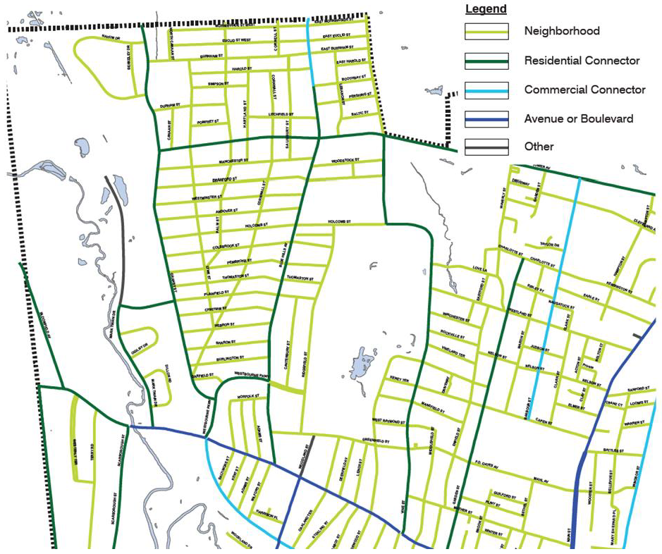
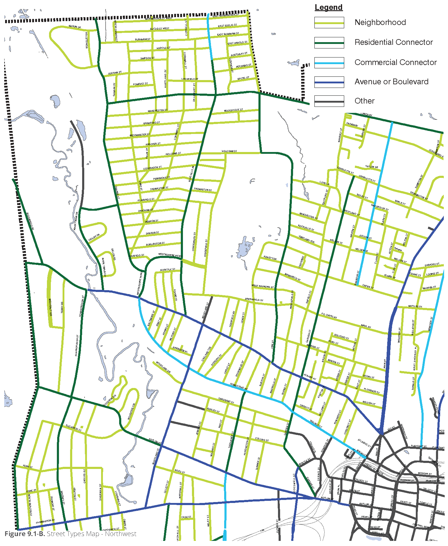
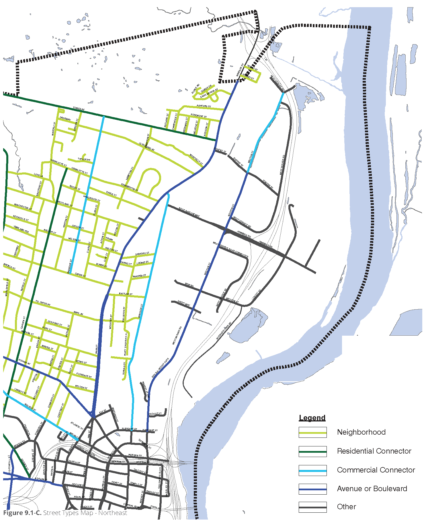
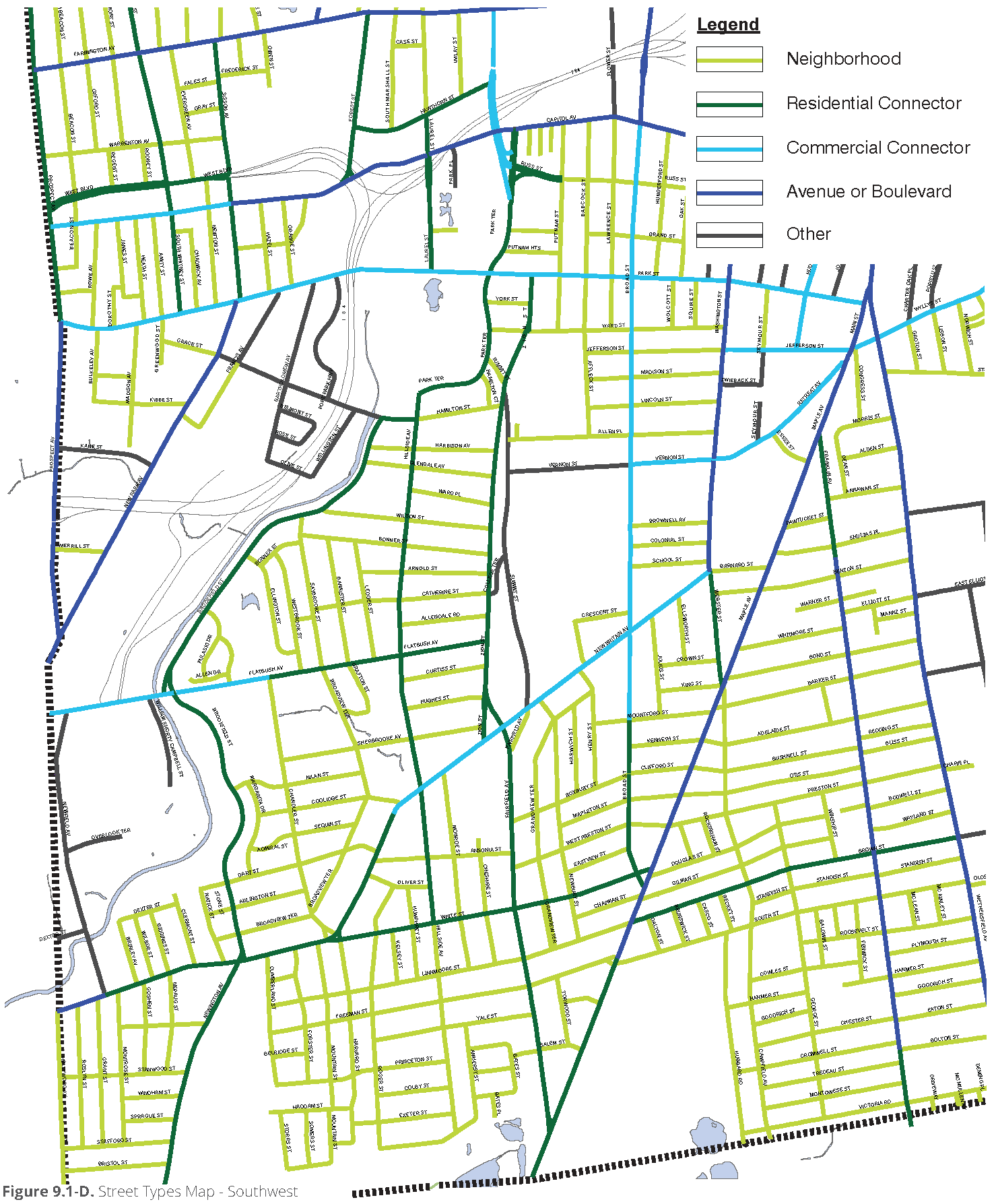
Street Types. All streets shall match one of the street types (refer to 9.4 through 9.8), whether publicly dedicated or privately held.
B.
Public Use. All streets shall be available for public use at all times, except gated and private streets approved by the commission and except for streets duly authorized for a temporary use per 3.7 Temporary Use Definitions & Use-Specific Conditions.
9.1.4 - STREET CONSTRUCTION SPECIFICATIONS
Any construction related to streets shall follow these regulations and the department of public works construction specification standards, which shall be consistent with these regulations. The principles contained in the Urban Street Design Guide of the National Association of City Transportation Officials published in 2013, as amended, shall serve as a guide for these regulations and decisions made pursuant thereto.
9.1.5 - SELECTION OF A STREET TYPE
A.
Selection of Street Types for New Streets. For new streets, the commission shall select the applicable street type as part of the review process for an overall development or as part of any decision on streets made pursuant to 1.3.11 Decisions on Streets, Street Lighting, & Building Lines.
B.
Selection of Street Types for Existing Streets. When an existing street becomes subject to this section in accordance with 9.1.2 Applicability, the zoning administrator, in consultation with the department of public works, shall select the applicable street type for the design of the street. If the zoning administrator and department of public works disagree on the appropriate street type, then the selection of the street type shall be made by the commission as an item of regular business at any meeting.
C.
Selection Criteria. When selecting the street type for a new or existing street, the decision-maker shall take into account the following factors:
(1)
The intent of the street types.
(2)
The street requirements for the street types.
(3)
The most recent average daily traffic counts available to the city.
(4)
Existing and projected intersection counts for pedestrians and bicyclists, if available.
(5)
Existing and projected on-street parking utilization and demand data, if available.
(6)
Existing land uses and zoning districts on adjacent parcels.
(7)
The bike plan, and Figure 9.1-A Bike Plan Facilities Map.
9.1.6 - STREETSCAPE DESIGN SUBMITTAL
Once a street type has been selected, the city or a private property owner, as applicable, must develop a streetscape design, to be approved by the zoning administrator in consultation with the department of public works, which includes articulation of the following elements:
A.
Landscape Zone or Furnishings Zone. Refer to the street type requirements for the street to determine which type of buffer area is required or allowed.
B.
Street Trees. Trees must be planted and installed in accordance with 6.7 Street Trees.
C.
Sidewalk Pavement Design. Sidewalk paving materials and pattern shall be identified in the submittal.
D.
Street Furnishings. For buildings with commercial or mixed uses, benches, seatwalls, planters, planter fences, trash receptacles, and bicycle racks shall be specified and quantities and locations listed.
E.
Landscape Design. Ground plane vegetation shall be designated for any landscape bed areas, planter areas, and tree wells.
F.
Lighting. Lighting in the right-of-way shall be specified, and locations and quantities noted. Installation shall be coordinated with the department of public works and be consistent with the principles of 6.15 Lighting.
G.
Identity Elements. Any other elements designed to establish the identity of each street, such as banners, pavement markers, way-finding, artwork, or signage, shall be included in the streetscape design submittal.
H.
Bicycle Facilities. Bicycle facilities must be provided in accordance with the bike plan, except that for new streets, the commission shall determine the bicycle facilities to be provided.
Figure 9.1-A Bike Plan Facilities Map
9.2.1 - GENERAL
The standards in this section outline acceptable street configurations for each street type.
9.2.2 - DEVIATIONS
Deviations from these standards may be granted by the decision-making body to address site-specific conditions, provided that the deviations are consistent with the intent of the street type selected. Figures depicting street sections are meant to be illustrative of the acceptable street type configurations and are not meant to be exclusive.
9.2.3 - TYPICAL STREET ELEMENTS
Typical elements of a public right-of-way are divided into the roadway realm and pedestrian realm. Each street type detailed in this article outlines which facilities are applicable. Refer to Figure 9.2-A Typical Right-of-Way Elements.
A.
Roadway Realm. The roadway realm is comprised of travel lanes for vehicles and/or bicycles and parking lanes.
B.
Pedestrian Realm. The pedestrian realm is typically comprised of pedestrian facilities, such as sidewalk, sidepath, or off-street bicycle path, and a buffer area that serves to buffer people walking and biking from vehicles in the roadway realm.
(1)
Sidewalk. Sidewalks shall be installed along every street frontage per the following.
(a)
Sidewalk Width. A minimum sidewalk width of 5 feet is recommended on residential streets and 6 feet minimum width on narrow commercial streets. A minimum sidewalk width of 10 feet is recommended in: the DT districts; the Transit Oriented Development Overlay; and busy pedestrian areas, such as near the primary entrances of theaters, schools, stadiums/arenas, and buildings exceeding 4 stories in height when those entrances are located within 50' of the property line. A minimum sidewalk width of 15 feet is recommended where Outdoor Cafes or similar uses are anticipated.
(b)
Sidewalk Material. Sidewalks shall be constructed of concrete or other material acceptable to the department of public works.
(c)
Ramps. Ramps and crosswalks shall be designed in accordance with 9.3.3 B.
(d)
Location. The outermost edge of the sidewalk as determined by the edge furthest from the curb shall be located within one foot of the abutting property line as is feasible, given site constraints such as topography, mature trees, and utility structures.
(2)
Tactile Warning Tiles. Tactile warning tiles, crosswalk striping requirements, and pedestrian crossing signage shall be provided in accordance with street construction guidelines of the department of public works.
(3)
Buffer Area. The buffer area is between the roadway realm and the sidewalk within the pedestrian realm. Refer to the street type for minimum sizes and allowable types of buffer areas. The buffer area shall consist of one or both of the following:
(a)
Landscape Zone. A landscape zone is a landscaped area between the back of curb and edge of the sidewalk in which street trees, swales, lighting, and signage may be located. Landscape zones are typically used along the frontage of residential buildings.
(b)
Furnishings Zone. A furnishings zone is a hardscape area that extends from the sidewalk to the back of curb, in which street trees in wells or planters, street furniture, lighting, and signage may be located. Furnishings zones are typically used adjacent to mixed-use, commercial, or office buildings.
(i)
Any raised planters shall be less than 20 feet long and at least 1.5 feet away from the edge of a sidewalk adjacent to on-street parking (and 2.5 feet away from the edge of a sidewalk adjacent to angled on-street parking), with the exception of 3-sided tree wells as shown in 6.7.3 D.(4), which shall not be subject to the distance requirement from the edge of a sidewalk.
(ii)
Space occupied by street furnishings listed in 9.1.6 D. and any furnishings related to an Outdoor Cafe, which are placed on the sidewalk for more than 6 hours per day for 4 months per year, may not be counted toward the calculation of sidewalk clear space required per each Street Type.
(c)
Utilities. Above-ground utility boxes shall not be located anywhere in the pedestrian realm, unless absolutely necessary. The preferred locations for utility boxes are: underground, incorporated into a building structure, or set back from the pedestrian realm and screened per 6.12. Underground conduits and lines are discouraged from being located underneath the pedestrian realm. The preferred location of underground conduits and lines is in the roadway realm.
9.2.4 - VEHICULAR TRAVEL LANES
The number and width of vehicular travel lanes are determined by the street type.
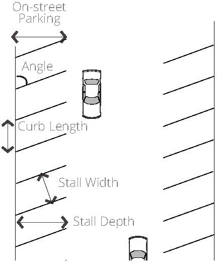
9.2.5 - ON-STREET PARKING
On-street parking, as permitted on designated street types, shall meet the following requirements.
A.
Parallel and diagonal parking is permitted on designated street types.
B.
The appropriate dimensions for on-street parking spaces are outlined in Figure 9.2-B On-Street Parking Dimensions and Figure 9.2-C On-Street Parking Layout.
C.
A decision-maker may approve deviations from these dimensions as circumstances require. For example, an on-street parking space adjacent to a bicycle lane buffer may be only 7 feet wide.
D.
The width of a parking space shall be measured from the center of a stripe to either a center stripe or a curb, as applicable.
E.
On-street parking may also be dedicated to bicycle parking, which shall be provided with the use of bicycle racks protected from cars by a raised curb, railing, bollards, or other physical demarcation.
9.2.6 - BICYCLE FACILITIES
The following types of bicycle accommodations are permitted, where and as shown on the bike plan, and in accordance with these regulations:
A.
Bicycle Boulevard. A low-speed and low-volume street designed to optimize bicycle travel, typically incorporating various traffic calming treatments that prioritize the safe and efficient movement of bicyclists and that may discourage through motor vehicle traffic.
B.
Buffered Bike Lane. A striped bike lane with a painted, colored, or textured at-grade buffer space used to separate the bike lane from the adjacent motor vehicle land and/or parking lane.
C.
Separated Bike Lane. A bike lane that is physically separated by on-street parking, bollards, delineators, planters, raised medians, or raised facilities from motor vehicle traffic.
D.
Shared Roadway. A facility allowing bicyclists and motor vehicles to use the same roadway space without any separate right-of-way designations, typically in locations where sufficient right-of-way does not accommodate a striped bicycle lane.
E.
Sidepath. A separated facility for the exclusive use of bicyclists and pedestrians, typically physically separated from motor vehicles with open space or a barrier (such as trees).
F.
Striped Bike Lane. An exclusive space on the roadway for bicycle travel, which is signified by pavement markings, striping, and signage, typically located on the right side of a street.
9.2.7 - STORMWATER MANAGEMENT
Street design should adhere to the low impact development principles described in 6.14 Stormwater & Low Impact Development. Design elements may include drainage swales and slotted curbs into the landscape zone or permeable paving in the parking lane.
9.2.8 - MEDIANS
Median islands are used to calm wide roadways and provide space for the establishment of a tree canopy. Median islands may also be used as pedestrian refuge islands to aid in pedestrian crossing of wide roadways or to prohibit pedestrian crossing in mid-block locations.
A.
Use.
(1)
Median islands should be used in areas where the presence of left turn lane pockets or a 2-way center left turn lane creates a continuous separation of opposing traffic lanes.
(2)
Median islands should be located in areas that do not conflict with left turn demand or areas where the desired effect is to prohibit left turns.
B.
Existing Median Islands. Existing landscaped median islands, with a width greater than or equal to 6 feet, may not be removed or substantially reduced in size without consideration of factors contained in 9.1.5 C.
C.
New Median Islands.
(1)
Median islands shall have a minimum width of 6 feet.
(2)
The exterior face of the curb for median islands shall be offset a minimum of one foot from adjacent traffic lane.
(3)
Median islands shall be landscaped as feasible of at least 75 percent of the island, and should be landscaped and maintained in a way that ensures proper driver sightlines. In the absence of a fixed water supply to maintain plantings in the median, plantings should be low-maintenance and native to the area.
(4)
Median island pavement surfaces, when applied, shall be composed of concrete, brick, or stone, or shall be of pervious concrete, brick, or stone surfaces approved for durability by the department of public works.
(5)
Median islands shall incorporate pedestrian refuges at crosswalks as feasible.
Figure 9.2-A Typical Right-of-Way Elements
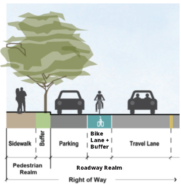
Figure 9.2-B On-Street Parking Dimensions
***Expand table to lock table headings in place while scrolling***
Figure 9.2-C On-Street Parking Layout
9.3.1 - GENERAL LAYOUT STANDARDS
The following standards apply to new streets or newly platted streets.
A.
Treatment of Natural Features. Streets shall be designed to respect natural features, such as rivers, woodlands, or slopes.
B.
Street Network. The network of streets shall form an interconnected pattern with multiple intersections. Closely spaced offset intersections should be avoided.
C.
Existing Streets. The arrangement of streets shall provide for the continuation of existing streets from adjoining areas into new subdivisions and retail areas.
9.3.2 - DISCONNECTED STREETS
Disconnected streets may take either of the following forms:
A.
Stub Streets. Where adjoining areas are not subdivided, streets in new subdivisions shall be extended to the boundary line of the tract to make provision for the future extension of streets into adjacent areas.
(1)
Stub streets shall be provided at intervals no greater than the maximum block length and width per the Subdivision Regulations or any applicable overlay (refer to 5.0 Special Overlays).
(2)
Existing stub streets adjacent to a proposed subdivision shall be connected.
(3)
If a stub street is created, every effort shall be made to maintain a bicycle and pedestrian connection to the adjacent street.
(4)
Wherever possible, stub streets should be provided with a feature, such as a hammerhead or temporary cul-de-sac, which would allow vehicles (including large trucks used for waste pickup and emergency services) to turn around.
B.
Cul-de-Sac Streets. Cul-de-sac streets are not permitted except where natural features prohibit the inclusion of a U-shaped street accessing the location. The following parameters shall be incorporated when the exception is taken:
(1)
The cul-de-sac shall not be more than 300 feet in length as measured along the centerline from the closest intersection.
Figure 9.3-A Actual Right Turn Radius with
On-Street Parking
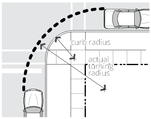
Figure 9.3-B Wide Street Crossing with
Pedestrian Refuge Median
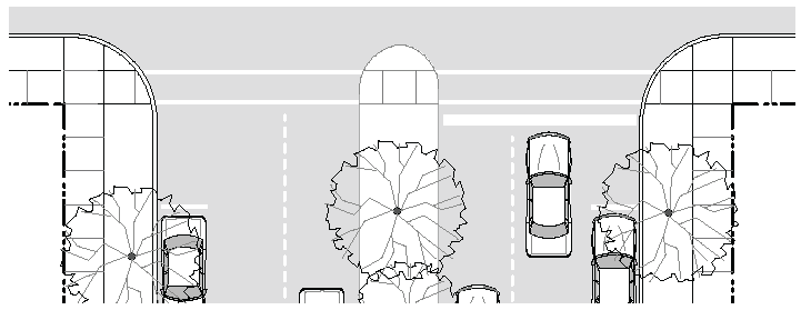
Figure 9.3-C Illustration of Bulb-Out
(2)
The cul-de-sac is encouraged to have a maximum outside turning radius of 50 feet.
(3)
A narrow Neighborhood Street section shall be utilized for the pavement and the remaining center of the circular area shall be landscaped.
(4)
A pedestrian sidewalk connection should be provided from the cul-de-sac through to the next closest street or sidewalk.
9.3.3 - INTERSECTIONS
A.
Curb Radii. The following curb radii shall be utilized unless otherwise authorized by the zoning administrator.
(1)
Intersections should be designed for actual turning radius of the typical design vehicle as opposed to the maximum design vehicle. Small curb radii at intersections shorten pedestrian crossing distances and reduce vehicle turning speeds, thereby balancing the ease of travel of the vehicles and pedestrians. Refer to Figure 9.3-A Actual Right Turn Radius with On-Street Parking.
(2)
Neighborhood and Connector Streets. At the intersection of any street with a Neighborhood or a Connector Street, the following curb radii shall be utilized.
(a)
With on-street parking on both streets, a radius no greater than 5 feet shall be required.
(b)
Without on-street parking, a radius no greater than 10 feet is required.
(3)
Avenue Streets. At the intersection of Avenues to Avenues or Boulevards, the following curb radii shall be utilized.
(a)
With on-street parking on both streets, a 5 foot radius is required.
(b)
Without on-street parking on either street, a radius no greater than 10 feet is required.
(4)
Larger Radius. When the design vehicle requires a larger curb radius and no on-street parking exists, a radius no greater than 25 feet is required.
(5)
Alley Intersections. The curb radius at intersections involving Alleys shall be no greater than 5 feet.
B.
Crosswalks. Crosswalks shall be required at all intersections involving Connectors, Avenues, and Boulevards.
(1)
Dimensions. Crosswalks shall be minimum 6 feet in width, measured from mid-stripe to mid-stripe, per MUTCD.
(2)
Markings. Crosswalks shall be appropriately indicated on the finished street surface with painted markings and/or textured or colored pavement. Crosswalks shall be comprised of retroreflective pavement markings and/or textured or colored pavement.
(3)
Crossing Distances. To encourage walking, typical crosswalks shall not extend over 48 feet without a landscape median or other pedestrian refuge to mitigate the effects of vehicular traffic on crossing and increase pedestrian safety and comfort. Refer to Figure 9.3-B Wide Street Crossing with Pedestrian Refuge Median.
(4)
Accessible Ramps. Accessible ramps and tactile warning strips, per the American Disabilities Act or any more stringent state requirement, are required where all sidewalks or trails terminate at a crosswalk or curb.
(5)
Ramp Orientation. Ramps shall be oriented perpendicular to traffic, requiring two ramps per corner at intersecting streets. Alternative designs as outlined in Americans with Disabilities Act publications and the Manual on Uniform Traffic Control Devices are allowed when approved by the department of public works.
(6)
Mid-Block Crosswalks. Mid-block crosswalks with average daily traffic counts of 4,000 should utilize additional notification for drivers such as a button activated flashing crosswalk warning. Such devices shall be compliant with recommendations of the Manual on Uniform Traffic Control Devices, and such crosswalks shall comply with the Americans with Disabilities Act.
C.
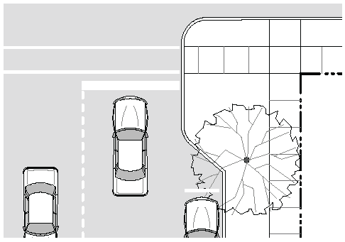
Bulb-outs. To shorten pedestrian crossing distances and improve visibility, bulb-outs (also known as curb extensions) should be used at intersections where on-street parking is permitted in proximity to the crossing on the street perpendicular to the crossing (unless otherwise required by the department of public works). Refer to Figure 9.3-C Illustration of Bulb-Out.
(1)
The depth of the bulb-out shall be two-thirds to three-quarters of the depth of the utilized on-street parking.
(2)
The radius of the bulb-out shall match the requirements for the intersection.
D.
Roundabouts. Roundabout intersections are encouraged, where conditions allow, for intersections involving Commercial Connectors, Avenues, and Boulevards. When well-designed, roundabouts reduce crashes between walkers, bikers, and vehicle drivers, dispense with electric power, and create a place to pile snow. The publication "Context-Sensitive Solutions in Designing Major Urban Thoroughfares" may be used for guidance in roundabout design.
E.
Bicycle Facilities. Bicycle facilities must be provided at intersections in accordance with current or planned facilities at adjacent roads and in accordance with the bike plan. Such facilities may include combined lanes, bike pockets, bike boxes, two-stage left-turn boxes, protected intersections, median refuge islands, and roundabout facilities as defined in the bike plan. Provision must be made for harmonious treatment of bicycle facilities in an intersection with bus stops and street parking.
9.4.1 - INTENT
The Neighborhood Street is a very low capacity street designed for slow speeds that primarily serves those properties directly adjacent to it. It exists in residential neighborhoods with building stock largely composed of row houses, condominiums, and One-Unit Dwellings. Refer to the following typical proposed sections in Figure 9.4-A Neighborhood Street.
9.4.2 - GENERAL REQUIREMENTS
Neighborhood Streets shall be developed using the standards in Figure 9.4-B Neighborhood Street Requirements.
9.4.3 - EXAMPLE NEIGHBORHOOD STREETS
Examples of Neighborhood Streets include: Andover Street, Broadview Terrace, Mather Street, Preston Street, and Sargeant Street.
Figure 9.4-A Neighborhood Street
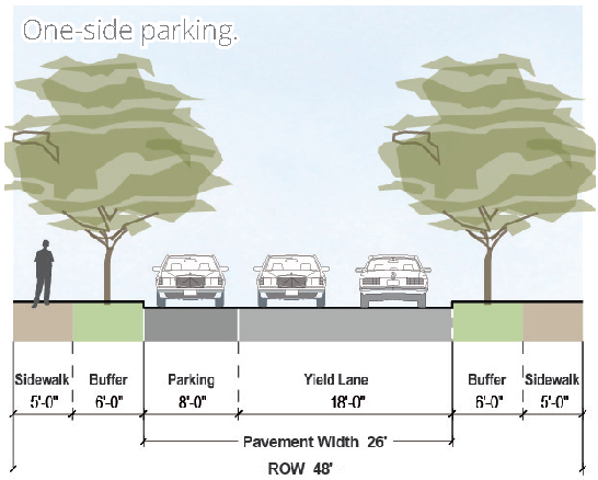
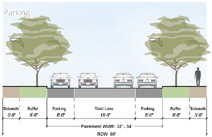
Figure 9.4-B Neighborhood Street Requirements
9.5.1 - INTENT
The Residential Connector is a low capacity street for slow speeds with a standard right-of-way. It primarily serves residences and a small number of businesses directly adjacent to it. In addition, it serves as a main street within the neighborhood. Refer to the typical proposed sections in Figure 9.5-A Typical Residential Connector (1 of 2) and Figure 9.5-C Typical Residential Connector (2 of 2).
9.5.2 - GENERAL REQUIREMENTS
The Residential Connector shall be developed using the standards in Figure 9.5-B Residential Connector Requirements.
9.5.3 - EXAMPLE RESIDENTIAL CONNECTORS
Examples of Residential Connectors include: Blue Hills Avenue, Garden Street, Hillside Avenue, Scarborough Street, and West Boulevard.
Figure 9.5-A Typical Residential Connector
(1 of 2)
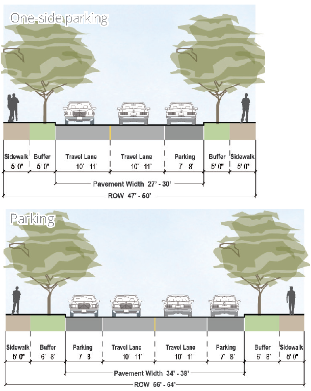
Figure 9.5-B Residential Connector
Requirements
Figure 9.5-C Typical Residential Connector
(2 of 2)
9.6.1 - INTENT
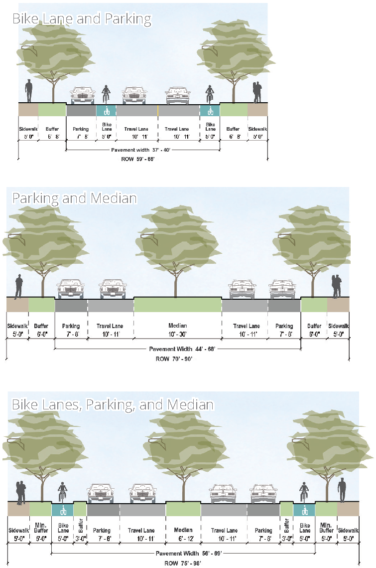
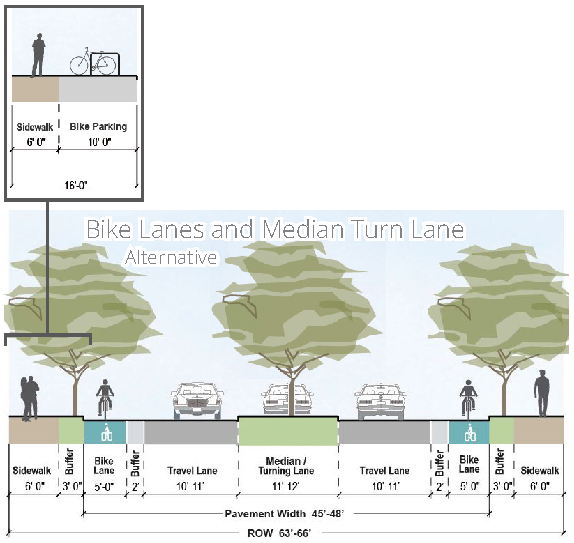
The Commercial Connector is a low to medium capacity street for medium speeds and it primarily serves businesses, many of which are large offices or auto-related. It provides multi-modal crosstown connections. Refer to the following typical proposed sections in Figure 9.6-A Typical Commercial Connector Street and Figure 9.6-C Alternative Commercial Connector.
9.6.2 - GENERAL REQUIREMENTS
Commercial Connectors shall be developed using the standards in Figure 9.6-B Commercial Connector Requirements.
9.6.3 - EXAMPLE COMMERCIAL CONNECTORS
Examples of Commercial Connectors include: Barbour Street, Broad Street, Homestead Avenue, New Britain Avenue, and Park Street.
Figure 9.6-A Typical Commercial Connector Street
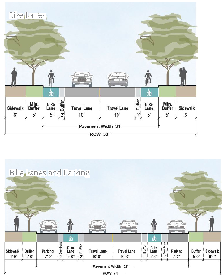
Figure 9.6-B Commercial Connector
Requirements
Figure 9.6-C Alternative Commercial Connector
9.7.1 - INTENT
The Avenue is a medium capacity street for low to medium speeds. The buildings directly adjacent to it are primarily 2-3 story mixed-use with the ground floor dedicated to neighborhood and general retail and services. It is designed to function as a multi-modal key retail corridor for the city. Refer to the following typical proposed sections in Figure 9.7-A Typical Avenue.
9.7.2 - GENERAL REQUIREMENTS
Avenues shall be developed using the standards in Figure 9.7-B Avenue Requirements.
9.7.3 - EXAMPLE AVENUES
Examples of Avenues include: Albany Avenue, Farmington Avenue, Maple Avenue, Washington Street, and Wethersfield Avenue.
Figure 9.7-A Typical Avenue
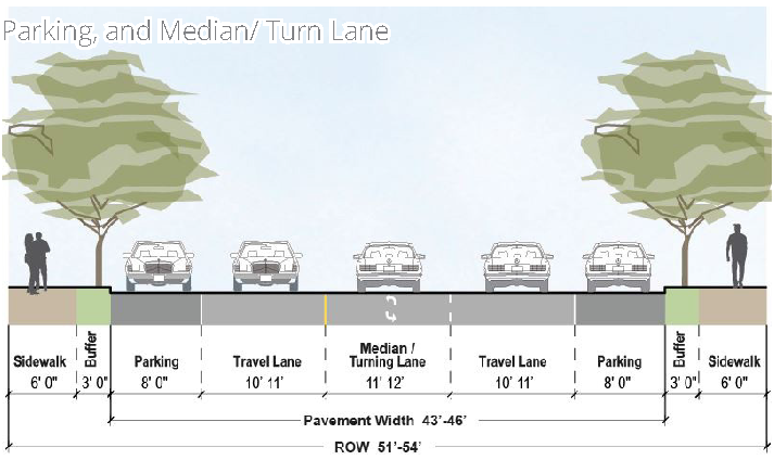
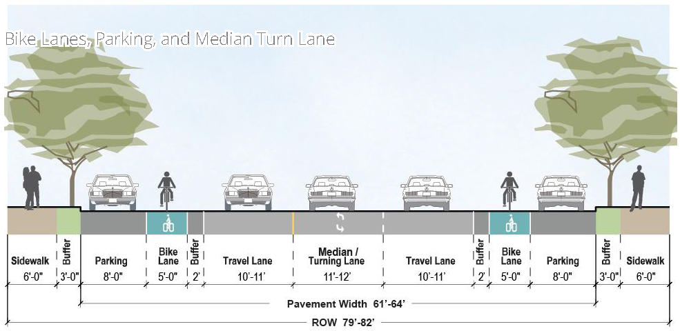
Figure 9.7-B Avenue Requirements
9.8.1 - INTENT
The Boulevard is a high capacity street for medium to high speeds. The buildings directly adjacent to it are primarily 1-2 story general and neighborhood retail, and residential. It functions as a key corridor that connects neighborhoods and residents within the city as well as a destination in itself for the community to gather. Refer to the following typical proposed section in Figure 9.8-A Typical Boulevard.
9.8.2 - GENERAL REQUIREMENTS
Boulevards shall be developed using the guidelines in Figure 9.8-B Boulevard Requirements.
9.8.3 - EXAMPLE BOULEVARDS
Examples of Boulevards include: Airport Road, Franklin Avenue, Mark Twain Drive, North Main Street, and Trumbull Street.
Figure 9.8-A Typical Boulevard
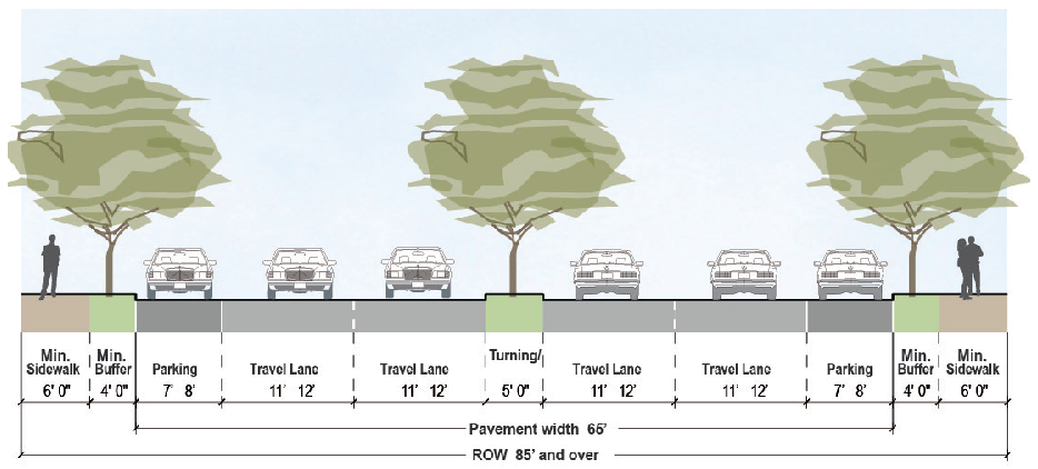
Figure 9.8-B Boulevard Requirements