
Hartford City Zoning Code
6.0
SITEWORK & LANDSCAPE
6.3 - Ground Plane Vegetation
All unpaved areas shall be covered by one of the following.
6.7 - Street Trees
A street tree is defined as any tree lining a street to achieve the purpose described in the following intent and which otherwise meets the requirements of this section.
6.10 - Interior Parking Lot Landscape
Parking lot interior is defined as the area dedicated to parking on a given parcel as measured from edge of pavement to edge of pavement.
6.1.1 - INTENT
The landscape standards outlined in this chapter are designed to meet the following set of goals.
A.
To provide for healthy, long-lived street trees within all public ways to improve the appearance of streets and create a buffer between pedestrian and vehicular travel lanes.
B.
To increase the compatibility of adjacent uses and minimize the adverse impacts created by adjoining or neighboring uses.
C.
To promote the prudent use of water and energy resources by achieving and maintaining sustainable, functional landscapes.
D.
To plant, protect and preserve trees and landscaping that clean the air, calm traffic, reduce the urban heat island effect, provide shade that reduces energy costs, increase property values, reduce stormwater runoff, and otherwise enhance quality of life.
E.
To mitigate the impacts of climate change through prudent management of natural resources and wildlife habitat.
F.
To meet the citywide tree canopy goal of 35% by 2070.
(Amend. of 2-22-2022(1))
6.1.2 - APPLICABILITY
Landscaping, trees, buffers, soil management, and other site improvements shall be installed as detailed in this chapter.
A.
General Compliance. Application of this section to existing uses shall occur with the following developments.
(1)
Any development of new or significant improvements to existing parking lots, loading facilities, and driveways. Significant improvements include new driveways, new spaces, new medians, new loading facilities, removal or pulverization of an existing parking lot (excluding milling and paving), or complete reorganization of the parking and aisles.
(2)
Alteration to an existing principal or accessory structure that results in a change of 15 percent or more in the structure's gross floor area.
(3)
When compliance is triggered for existing parking lots, landscape improvements shall take precedence over parking requirements.
(4)
Any project involving new or existing trees must comply with the Tree Ordinance (Article VI of the City Code of Ordinances).
(5)
An active list of permitted trees can be obtained from the City Forester.
B.
Buffers. Landscape buffers are required according to the provisions in this section with the following exceptions.
(1)
Shared Driveways and Parking. Buffers shall not be required along a property line over which a curb cut, parking lot, or aisle is shared between 2 adjoining lots, as long as appropriate documentation regarding uniform ownership or cooperation among multiple owners is provided.
(2)
Points of Access. Buffering is not required at driveways or other points of access to a lot.
C.
Temporary Uses. These provisions do not apply to temporary uses, unless determined otherwise by the zoning administrator.
(Amend. of 2-22-2022(1))
6.1.3 - COMPUTATION
In this chapter, when computation of the number of trees, shrubs, or other required material results in a fractional number, any result of 0.5 or more shall be rounded up to the next consecutive whole number. Any fractional result of less than 0.5 may be rounded down to the previous consecutive whole number.
6.1.4 - VISIBILITY AT INTERSECTIONS
No wall, fence, shrubbery or trees shall be erected, maintained or planted on any lot which unreasonably or dangerously obstructs or interferes with visibility of drivers of vehicles on a curve or at any street intersection. At the intersection of 2 streets, there shall be no obstruction (other than a building required to be built within the sight triangle per the district and Building Type) exceeding 3 feet above the street grade within the sight triangle created between the following points: the point of the intersection of the curb lines of the two streets and the two points along each street that are located 15 feet from the intersection of the curb lines.
6.2.1 - INTENT
The following provisions aid in ensuring that all required landscaping is installed and maintained properly.
6.2.2 - APPLICABILITY
These provisions apply to landscape installation as required by this section.
6.2.3 - REQUIREMENTS
The installation of landscaping shall adhere to the following standards.
A.
National Standards. Best management practices and procedures according to the nationally accepted standards shall be practiced. All landscaping and trees shall be installed in conformance with the practices and procedures established by the most recent edition of the ANSI A300 Part 5 (available from the Tree Care Industry Association).
B.
Installation. All landscaping shall be installed according to sound nursery practices in a manner designed to encourage vigorous growth. All landscape material, living and non-living, shall be healthy and in place prior to issuance of final certificate of completeness.
(1)
If seasonal conditions preclude the complete installation, a cash escrow or irrevocable letter of credit, equal to 1.5 times the installation costs as estimated by a qualified professional.
(2)
Complete installation is required within 9 months of the issuance of the temporary certificate of completeness or occupancy permit or the cash escrow or letter of credit may be forfeited.
(3)
For trees that were transported to the site with root balls contained with wire basket, burlap, or similar materials, as much of such materials as possible shall be removed from the planting location, to avoid girdling of roots as the tree matures.
(4)
A root flare must be exposed and at grade.
C.
Tree Measurement. Caliper is the measured diameter (inches) of the tree trunk as follows:
(1)
Caliper measurement of the trunk shall be taken 6 inches above the ground or top of the rootball up to and including 4 inch caliper size.
(2)
If the caliper at 6 inches above the ground exceeds 4 inches, the caliper should be measured at 12 inches above the ground or top of the rootball.
(3)
Caliper should be an average of measurements when a tree's trunk deviates significantly from a true circle.
D.
Plant Size Requirements. Plant material shall be sized according to Figure 6.2-A Plant Material Size at Installation unless otherwise noted in this section.
Figure 6.2-A Plant Material Size at Installation
***Expand table to lock table headings in place while scrolling***
E.
Condition and Selection of Planting Materials. The landscaping materials used shall be free from visible signs of disease, infestation, or physical defect at the time of planting. Plant materials shall:
(1)
Be appropriate for the conditions of the location, including sun and wind exposure, air quality, salt exposure, soil type, expected moisture content of soil, and slope.
(2)
Not be an invasive or a potentially invasive species as identified by the Connecticut Invasive Plant Working Group, the Connecticut Invasive Plants Council, as authorized in Connecticut Statute 22a-381b, or the State of Connecticut Department of Energy and Environmental Protection.
(3)
Be, wherever possible, native or naturalized to Connecticut.
F.
Compost, Mulch, and Organic Matter. Compost, mulch, and organic matter may be utilized within the soil mix to reduce the need for fertilizers and increase water retention.
G.
Establishment. All installed plant material shall be fully maintained until established, including watering, fertilizing, and replacement as necessary. Establishment is defined as survival in healthy and undamaged condition for a minimum of five years. The landowner, or successors in interest, or agent, if any, shall be jointly and severally responsible for maintenance and replacement.
H.
Permeable Surface. For each tree preserved or planted, a minimum amount of permeable surface area is required unless otherwise stated in these regulations. Refer to Figure 6.2-B, Required Soil Volumes & Permeable Area per Tree. Review 6.2.3.H (1) and (2) for feasibility.
(1)
At least 70 percent of the canopy limits of preserved trees should have a permeable surface.
(2)
Permeable area for one tree cannot count toward that of another tree.
I.
Structural Soil.
(1)
When the soil surface area of a tree will extend below any pavement, structural soil may be used underneath that pavement. Refer to Figure 6.2-B Recommended Soil Volumes & Permeable Area per Tree.
(2)
Structural soil is a medium that can be compacted to pavement design and installation requirements while still permitting root growth. It is a mixture of gap-graded gravels (made of crushed stone), clay loam, and a hydrogel stabilizing agent to keep the mixture from separating. It provides an integrated, root penetrable, high strength pavement system that shifts design away from individual tree pits.
J.
Required Soil Volume. When the required soil volume as outlined in Figure 6.2-B cannot be achieved, the following minimum requirements are to be met:
1.
Minimum of 5x10x3 (150 cu ft) of soil is to be provided.
2.
Required volume can be achieved by the use of structural soils or another method approved by the City Forester.
Figure 6.2-B Required Soil Volumes & Permeable Area per Tree
***Expand table to lock table headings in place while scrolling***
(Amend. of 2-22-2022(1))
6.3.1 - PLANTING BEDS
A.
Planting beds may include shrubs, ornamental grasses, ground cover, vines, annuals, or perennials.
B.
A minimum of 60 percent of the bed area shall be covered in plant material. The remaining portion of the bed shall be covered with non-living permeable materials, such as mulch or landscape aggregate.
C.
Annual beds must be maintained seasonally, replanting as necessary.
6.3.2 - GRASS
Seeded, plugged, or sodded grass may be planted throughout landscaped areas. Grass shall be established within 90 days of planting or the area must be reseeded, replugged, or resodded.
6.3.3 - ARTIFICIAL TURF
A.
Definitions.
(1)
Artificial Turf. Any man-made surface manufactured from synthetic materials which simulate the appearance of live turf, grass, sod, or lawn.
(2)
Synthetic Infill Material. Any man-made infill from recycled or virgin materials including but not limited to ambient and cryogenic crumb rubber, coated crumb rubber, ethylene propylene diene monomer granules, thermoplastic elastomer granules, and recycled footwear.
(3)
Organic Infill Material. Any material utilizing organic components such as cork, coconut husks, rice husks, silica sand, or acrylic coated sand.
B.
Regulations.
(1)
The use of artificial turf containing synthetic infill materials shall be prohibited.
(2)
The use of artificial turf containing organic infill materials or containing no infill material shall be permitted, provided that:
(a)
Such use is in compliance with all applicable environmental laws and regulations; and
(b)
Any infill is composed completely of organic materials; and
(c)
The use of artificial turf does not exceed the impervious coverage requirements.
6.4.1 - REQUIRED QUANTITY OF LOT TREES
Sufficient trees shall be retained or planted on a lot so that the square footage of vegetative canopy of such trees, when mature, creates a significant canopy over the city as a whole.
A.
Quantity of Trees by Canopy Coverage. The percentage of canopy coverage required for each zoning district is listed in Figure 6.4-A Quantity of Trees Required, provided that more specific regulations for particular uses, such as buffers required in 6.8 Frontage Buffer, 6.9 Side & Rear Buffer, and 6.10 Interior Parking Lot Landscape, shall apply in addition to, and may be used to satisfy, the applicable requirements in Figure 6.4-A Quantity of Trees Required. Where a solar parking lot canopy is constructed in accordance with 4.20.6 C., the quantity of trees required by these regulations may be adjusted by the zoning administrator or the commission, as applicable, guided by the intent statements in 6.1.1, 6.4.1 E., and other provisions of these regulations.
B.
Measurement. The total canopy coverage for a lot is the sum of the canopy, at maturity, of the individual trees located on the lot. Refer to Figure 6.4-B Typical Canopy Size by Tree Size for Measuring.
(1)
Street trees located in the public right-of-way directly adjacent to the property line of the lot may be counted toward the canopy coverage for the lot.
(2)
For developments that encompass more than one lot, the required quantity shall be calculated for the total canopy for the total area of all of the lots.
(3)
For developments that span multiple blocks, the required quantity shall be calculated separately for each contiguous area of the development within a block.
C.
Credit for Existing Trees. Additional credit for canopy coverage may be granted for retaining healthy trees of appropriate species and location, subject to the approval of the city forester, as shown in Figure 6.4-C Existing Tree Canopy Credits.
D.
Alternative Compliance. Where existing conditions or other provisions of this section make it impracticable to meet the canopy coverage requirement on or adjacent to the site, the applicant shall plant sufficient trees to make up the shortfall with the location to be determined by the city forester. Impracticability may be proven by an applicant's submission of a daylighting study that shows insufficient sunlight to support trees or shrubs on the parcel. Off-site planting requirement may be met by contribution to the Hartford Tree Fund as determined by the City Forester.
E.
Negative Impacts. No new tree shall have a significant negative impact on any adjacent or nearby property owner. A property owner may not plant any tree which, when fully grown, will shade a solar collector existing at the time of the planting of the tree.
(Amend. of 2-22-2022(1))
6.4.2 - TREE TYPES
The types of trees permitted to be planted and their classification are listed in Figure 6.4-D Permitted Tree Types. Deviations or modifications to this list may be approved by the city forester from time to time. Planted trees shall be a combination of permitted species, where possible.
6.4.3 - TREE SPACING
Trees shall be planted no closer than 35, 25, and 15 feet apart for large, medium, and small trees, respectively, and as close to these intervals as practically possible to achieve continuous canopy coverage.
Figure 6.4-A Quantity of Trees Required
***Expand table to lock table headings in place while scrolling***
Figure 6.4-B Typical Canopy Size by Tree
Size for Measuring
***Expand table to lock table headings in place while scrolling***
Figure 6.4-C Existing Tree Canopy Credits
***Expand table to lock table headings in place while scrolling***
Figure 6.4-D Permitted Tree Types
Permitted tree types as per the City Forester's Approved Tree Species list, as posted on the Department of Public Works Forestry Division webpage.
(Amend. of 2-22-2022(1))
6.5.1 - LANDSCAPE MAINTENANCE
All landscaping, including trees, shall be maintained in good condition at all times, including during construction, to ensure the health of the landscaping and an orderly appearance.
A.
Applicability. All required landscape shall be maintained to adhere to all requirements of these regulations.
B.
Replacing Unhealthy Landscaping. Unhealthy landscaping shall be replaced with healthy, live plants or trees by the end of the next applicable growing season. This includes all plant material that shows dead branches over more than 25% of the normal branch pattern.
C.
Maintenance Responsibility. The owner is responsible for the maintenance, repair, and replacement of all landscaping, screening, and curbing required herein.
D.
Maintain Quality and Quantity. Maintenance shall preserve at least the same quantity, quality, and screening effectiveness as initially installed.
E.
City Inspection. All landscaped areas regulated by these regulations may be inspected by the city.
F.
Certified Arborist. All tree trimming, fertilization, and other similar work shall be performed by or under the management of an ISA certified arborist.
G.
ANSI Standards. All landscaping and trees shall be maintained according to the most recent edition of the American National Standards Institute, including its provisions on pruning, fertilizing, support systems, lighting protection, and safety.
H.
Tree Topping. Tree topping is not permitted. When necessary, crown reduction thinning or pruning is permitted. Refer to 6.7.3 B. for clear branch height of street trees.
I.
Tree Pruning. Nothing in this section shall be construed to prevent tree pruning to promote the health of a tree or for public safety purposes.
(Amend. of 2-22-2022(1))
6.5.2 - COMPLIANCE
After receiving zoning approval, an applicant must maintain significant landscaping, including trees, for the duration of the average expected lifespan of such landscaping or trees. Prior to the end of such average expected life span, removal of such significant landscaping or trees without replacement with like-kind material within a reasonable time shall constitute an ongoing violation of these zoning regulations, with each day constituting a separate violation, until such date as the landscaping or trees, as applicable, is restored.
6.6.1 - REMOVAL OF SIGNIFICANT TREES
No significant tree shall be removed without a permit from the city forester, pursuant to municipal code section 28-160. A significant tree is any tree with a diameter at breast height of 13 inches or more, or grove of trees or any tree type designated significant by the city forester, who shall determine significance on the basis of a tree's age, species, health, meaning within the community, historical importance, and similar factors; and, for the purposes of this section, a "significant tree" shall also mean a city tree or a grove of trees, as those terms are defined in municipal code section 28-154.
A.
Application. Any person wishing to remove a significant tree shall file a request to do so with the city forester.
B.
Required Findings for Approval. In order to grant permission to remove a significant tree, the city forester must make one or more of the following findings within 20 business days of receipt of the application:
(1)
The tree is in poor health or diseased with an expected life span less than 2 years.
(2)
The removal of the tree is unavoidable because the tree poses a danger to human safety, health and welfare.
(3)
The negative impact on the urban canopy of the removal of the significant tree can be adequately mitigated either by:
(a)
The planting of replacement tree or trees. In no case shall the quantity of replacement trees equal less than one caliper inch of replacement tree for each caliper inch at breast height of trees removed. Refer to the Tree Ordinance of the City of Hartford.
(b)
The deposit of money into the Hartford Tree Account which leads to the planting of a tree or trees with the cumulative equivalent diameter at breast height as the removed tree.
(Amend. of 2-22-2022(1))
6.6.2 - TREE PROTECTION DURING DEVELOPMENT ACTIVITY
A.
During development, all precautions shall be undertaken to prevent construction damage to existing trees, in accordance with guidelines in ANSI 300 Part 5.
B.
Protection shall not only include prevention of injury to the trunk and branches of existing trees, but also include the protection of the root systems.
C.
No person shall create a trench through the root system of an existing tree, expose the roots to the air overnight without a method for maintaining moisture, change the soil grade within the dripline of the tree, or cause soil compaction with the use of vehicles, machinery, or other method.
D.
The root systems of trees on adjacent lots shall also be protected.
E.
Before, during, and after the start of construction activity, the city forester shall have full access to the site to ensure that work is being done in accordance with these regulations and any additional requirements imposed on the project.
(Amend. of 2-22-2022(1))
6.6.3 - PENALTIES
Any person who removes a significant tree without prior permission from the city forester, causes significant root damage likely to lead to the death of a significant tree within 2 years, or causes the death of a significant tree through negligent construction practices or other means as determined by the city forester, shall be subject to a one-time fine equivalent to the value of the tree. The tree value shall be established using the Trunk Formula Method set forth in the latest edition of Guide for Plant Appraisal authored by the Council of Tree and Landscape Appraisers. Fines shall be held by the department of public works for forestry-related uses in the Hartford Tree Account, in accordance with municipal code section 28-164. Specific fines and fees are outlined in the Hartford Tree Ordinance (Hartford Municipal Code Chapter 28, Article VI).
(Amend. of 2-22-2022(1))
6.7.1 - INTENT
To line all streets with a consistent and appropriate planting of trees to establish tree canopy for environmental and aesthetic benefits for all streets.
6.7.2 - APPLICABILITY
The requirements of this section 6.7 Street Trees apply to tree planting along all new streets, realignments of existing streets, major renovations of sidewalks, and new construction of principal uses.
6.7.3 - MINIMUM STREET TREE REQUIREMENTS
The following standards apply to the installation of street trees.
A.
Exception. Street Trees are not required on alleys.
B.
Clear Branch Height. The clear branch height of a tree is the distance between the ground plane and the lowest branch of the tree at maturity. Minimum clear branch height is 8 feet for the portion of trees overhanging sidewalks and 15 feet for the portions of trees overhanging streets. At planting, minimum clear branch height of 5' is required with 6' preferred for all trees planted adjacent to a sidewalk or street.
C.
Street Tree Type. Refer to Figure 6.4-D Permitted Tree Types.
D.
Street Tree Spacing. Street trees shall be planted as follows:
(1)
Minimum per Street Frontage. Each lot is required to have one tree for every 40 feet of street frontage with a minimum of one street tree per street frontage.
(2)
Spacing. Street trees must be located a minimum of 2 feet and a maximum of 10 feet from the street, measured perpendicular to the curb.
(3)
Limited Space. Notwithstanding anything to the contrary in this section, the requirement to provide street trees shall be waived when there is less than 6 feet between the back of the curb and the front facade of the building.
(4)
Tree Wells. For trees installed within the public right of way, which are not within a continuous landscaped buffer strip, a tree well shall be used. Such tree wells shall be a minimum of 25 square feet. The opening of such tree well must include one of the following:
(a)
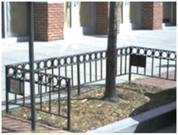
The tree well opening shall be fenced with an ornamental iron fence 18 inches above grade, with a top row of rings topped with a horizontal bar, which meets or exceeds the following specifications, as revised: ASTM A-787, ASTM A-653, and ASTM A-607. Such fences must be welded and painted black, and must be 3-sided, with the open side facing the curb. Refer to Figure 6.7-A Example of Tree Well Fencing.
(b)
Continuous granite curbing approximately 4 inches wide and 6 inches above the height of the sidewalk immediately adjacent to the well.
(c)
Granite posts at corners and every 4 feet along the perimeter of the well, such posts being approximately 8 to 10 inches above the height of the sidewalk immediately adjacent to the well, 4 inches wide, and 4 inches deep, with steel bracing on 3 sides of the tree well between such posts, with the open side facing the curb.
(d)
Other durable, long-lasting protective fencing or materials as the city forester deems appropriate given site conditions.
Figure 6.7-A Example of Tree Well Fencing
(photo credit: District Department of Transportation, DC.gov)
(Amend. of 2-22-2022(1))
6.8.1 - INTENT & APPLICABILITY
A.
Intent. To lessen the visual impact of certain uses or activities visible from the street.
B.
General Applicability. Applies to the street frontage, including front yards and corner side yards, properties in all DT, MS, CX, MX, NX, and N districts for the following types of uses:
(1)
Off-street surface parking areas located adjacent to a right of way, except:
(a)
Parking areas along alleys, other than when a residential district is located across the alley.
(b)
Parking areas for one- and 2-unit dwellings.
(2)
Outdoor sales lots identified in 3.3.4 G.
(3)
Transportation and utilities facilities identified in 3.3.8 B.
(4)
Ground-mounted transmission towers identified in 3.3.8 C.
(5)
Outdoor storage yard per 3.3.9 C. Large shade trees at least every 40' and a fence consistent with Section 6.13 are required along any right-of-way frontages.
(6)
Fuel pumps and canopies per 4.20.4 F.
(7)
Other uses as determined by the decision-making body or otherwise expressly required in these regulations.
(Amend. of 12-13-2022)
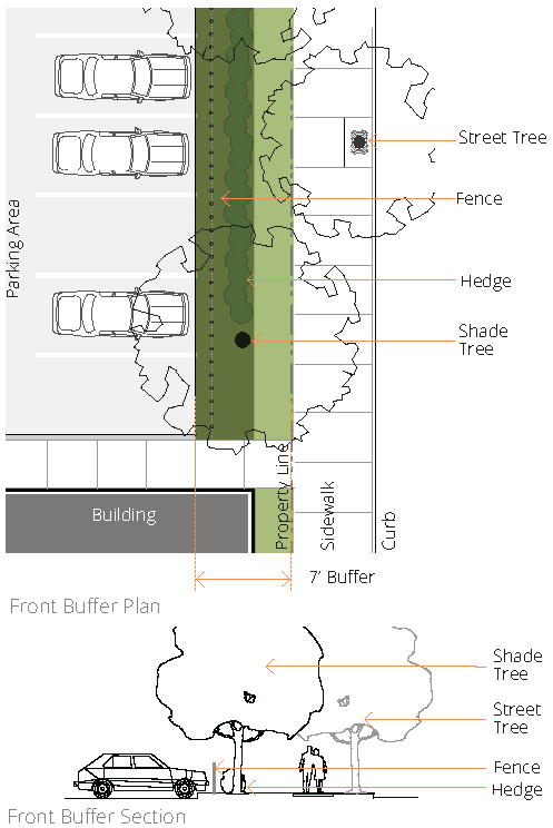
6.8.2 - FRONTAGE BUFFER REQUIREMENTS
Figure 6.8-A Frontage Buffer Plan & Section
6.9.1 - INTENT & APPLICABILITY
A.
Intent. To minimize the impact that one zoning district may have on a neighboring district and to provide a transition between districts.
B.
General Applicability. Applies to properties in all districts for the following types of uses:
(1)
Civic and Institutional Uses identified in 3.3.2 abutting a lot used for residential purposes.
(2)
Off-street surface or structured parking abutting a lot used for residential purposes.
(3)
General Retail Uses identified in 3.3.4.B, provided that the zoning administrator may deem these buffer requirements to be satisfied when reasonably applied to a single parcel containing more than one General Retail Use.
(4)
Lots subject to a Campus Overlay pursuant to 5.1, only along property lines adjacent to other lots, and not along property lines adjacent to public rights of way.
(5)
Outdoor storage yard per 3.3.9.C. Side and rear buffers are required, except where Outdoor Storage Yards are immediately adjacent to Infrastructure Uses and Industrial Uses.
(6)
Any uses for which Frontage Buffers are required by 6.8 Frontage Buffer.
(7)
Other uses as determined by the zoning decision-maker or otherwise expressly required in these regulations.
(Amend. of 12-13-2022)
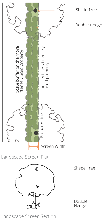
6.9.2 - SIDE & REAR BUFFER REQUIREMENTS
Figure 6.9-A Landscape Screen within Side & Rear Buffer
6.10.1 - INTENT & APPLICABILITY
A.
Intent. To provide shade, minimize paving & associated stormwater runoff, & improve the aesthetic look of parking lots.
B.
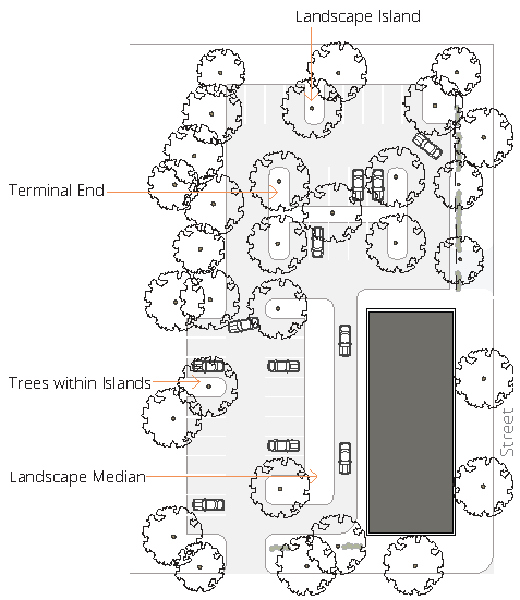
General Applicability. All off-street surface parking lots in all districts with more than one double-loaded aisle. For clarity, this section applies to parking lots with a double-loaded aisle plus a single-loaded aisle, as well as parking lots with a double-loaded aisle plus one travel lane additional to the travel lane used for parking.
C.
Other Internal Parking Lot Areas. Canopy coverage shall be provided in accordance with Figure 6.4-A Quantity of Trees Required, provided, however, that canopy coverage of 10 percent is required for any internal parking lot area.
D.
Existing Vegetation. Existing vegetation may be credited toward these requirements in accordance with Figure 6.4-C Existing Tree Canopy Credits.
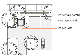
Figure 6.10-A Interior Parking Lot Landscaping
6.10.2 - INTERIOR PARKING LOT LANDSCAPE REQUIREMENTS
6.11.1 - INTENT & APPLICABILITY
A.
Intent. To establish minimum acceptable standards for the design of waterway buffers in order to: protect riparian habitat; reduce land development impacts on water quality and flows; provide for the environmentally sound use of our natural resources; remove pollutants delivered in urban stormwater; reduce erosion and control sedimentation; prevent or minimize loss of life, injuries, property damage, and other losses; and furnish scenic value and recreational opportunity. This section achieves these purposes by: restricting or prohibiting uses which are dangerous to health, safety and property due to water or erosion hazards, or which result in damaging increases in erosion or in flood heights or velocities; requiring that uses vulnerable to floods, including facilities which serve such uses, be protected against flood damage at the time of initial construction; and controlling the alteration of natural flood plains, stream channels, and natural protective barriers that help accommodate or channel flood waters and provide other benefits as described in the preceding sentence.
B.
General Applicability. Applies to perennial waterways of the Connecticut River, North Branch, South Branch, Cemetery Brook, Gully Brook, and Meadow Brook, as well as intermittent streams, defined as streams that flow at least 6 months out of a year but do not flow during part or all of the summer and may carry water during or after a rainstorm; and does not apply to portions of a waterway which are contained on 3 or 4 sides by a man-made structure, such as a concrete channel or underground pipe. Perennial and intermittent streams may be identified through site inspection or by United States Geological Survey maps, whichever is more inclusive and more updated.
6.11.2 - WATERWAY BUFFER REQUIREMENTS
A.
Parking, Structures, & Driveways. Unless otherwise specified by state or federal law, no parking, structures, or new driveways are permitted within the following waterway buffers:
(1)
Any floodplain.
(2)
50 lateral feet landward from the Connecticut River or North Branch, or 30 lateral feet landward from any other waterway, measured horizontally on a line perpendicular to the location of the annual average stream bank of both sides of a waterway.
(3)
25 lateral feet landward from the intermittent stream, measured horizontally on a line perpendicular to the location of the normal high water mark of both sides of an intermittent stream.
B.
Prohibited Uses. In addition, the following uses are prohibited within waterway buffers, except where incidental to an allowable use identified in 6.11.2.D: clearing of vegetation; grading, stripping, or other soil-disturbing practices; filling or dumping; draining the buffer area by ditching, underdrains or other systems; use, storage or application of pesticides; and storage or operation of motorized vehicles except for maintenance or emergency use.
C.
Vegetation. The waterway buffer shall include trees and plant material of a type and quantity sufficient to protect the physical and ecological integrity of the waterway ecosystem, provide distance between upland development and the waterway, and filter stormwater runoff from land development. Underbrush in the waterway buffer may not be removed or maintained, except for the maintenance of waterways within the flood control system by a public body; however, exotic and invasive species may be removed.
D.
Allowable Uses. The following allowable uses are authorized within the waterway buffer:
(1)
A paved walking or bicycle path installed more than 25 lateral feet landward from the waterway, or an unpaved walking or bicycle path installed more than 15 lateral feet landward from the waterway, measured horizontally on a line perpendicular to either the location of the annual average stream bank of both sides of a waterway or the location of the normal high water mark of both sides of an intermittent stream
(2)
Access to docks, piers, or beaches, provided that any impervious surface utilized to facilitate such access shall be as minimal as is required to accommodate the access
(3)
Encroachments of duly permitted sewer and underground utility systems, provided that such systems must cross the buffer area as close to perpendicular as practically possible
(4)
Fencing that does not interfere with the flow of the waterway, provided that any vegetation disturbed by the installation of the fence shall be restored.
(5)
Public streets duly authorized by the Commission or city council, as applicable.
(6)
Dikes, embankments, walls, reservoirs, pumping stations or drainage works approved by the Greater Hartford Flood Control Commission. Installation should be encouraged as far back from the Connecticut River as possible, to allow for more natural buffer/floodplain processes.
(7)
No allowable use may be permitted within the Waterway Buffer unless adequate and proper measures are specifically undertaken in connection with the location and/or construction of such use or uses to ensure that the water holding capacity of the floodplain is substantially maintained without upstream flooding, without endangering properties of adjacent owners, and without interfering or diminishing the basic flow of the waterway.
6.12.1 - INTENT & APPLICABILITY
A.
Intent. To reduce the visibility of open storage, refuse areas, loading, and utility appurtenances from public areas and adjacent properties.
B.
General Applicability. All dumpsters, loading areas, open storage, refuse areas, mechanical equipment, for-profit or non-profit donation bins (including temporary bins), and utility appurtenances and certain non-motorized vehicular equipment and marine equipment parking/storage areas (see 7.1.3 C.) in all districts.
6.12.2 - SCREENING REQUIREMENTS
Notes:
1 Vertical structured barrier to visibility at all times such as a fence or wall
2 This tree, if located within 50' of a parking space, may be utilized to meet the minimum shade requirements
3 Large private mechanical equipment is equal to or greater than 4' in height
4 Small private mechanical equipment is smaller than 4' in height
Figure 6.12-A Screening of Open Storage &
Refuse Areas
(Amend. of 1-10-2023)
6.13.1 - LOCATION & PLACEMENT
A.
Front and Corner Side Yards. No fence may be constructed closer than one foot to the front property line or corner side property lines, provided, however, that the requirements of 6.1.4 prevail. No fence greater than 50 percent opacity may be located in any front or corner side yard in the NX or N districts, or on the lot of any property used for residential purposes.
B.
Side and Rear Yards. Fences in side and rear yards may be located anywhere on the lot. However, property owners are encouraged to consult with neighboring property owners prior to installation when proposed along a property line.
C.
Face Direction. All fences shall be erected with the "good," "decorative," or "finished" side facing outward.
D.
Unauthorized Placement Prohibited. It is unlawful for any person to place or maintain any post, rail, fence, wires or other similar obstruction upon any street, sidewalk or public right-of-way in the city, except as otherwise expressly provided in these regulations.
6.13.2 - HEIGHT
A.
Minimum Height. The minimum height in any district for any fence is 3 feet.
B.
Maximum Height.
(1)
Front & Corner Side Yards. No fence more than 4 feet high shall be constructed in a front yard or corner side yard in any district. In the ID and CX-2 districts, on lots not abutting a lot assigned to any other zoning district, no fence more than 6 feet high shall be constructed in a front yard.
(2)
Industrial & Commercial Districts. In the ID-1, ID-2 and CX-2 districts, the maximum height of side and rear yard fences is 8 feet, except where the property is used for residential purposes.
(3)
Other Districts. In the DT, MS, CX-1, MX, NX, and N districts, and on any property used for residential purposes in any other district, the maximum height of any fence in a rear, side, or corner side yard is 6 feet except as otherwise provided in these regulations.
6.13.3 - TYPES & MATERIALS
A.
No person shall install or maintain any barbed wire, razor wire or ribbon, concertina wire, electrified wire or any other similar type of wire on any fence in the city.
B.
Chain link, plastic, and vinyl fencing are prohibited in any front yard or corner side yard in any district and shall not satisfy fencing requirements of 6.12.
6.13.4 - MAINTENANCE
Fences shall be kept in good repair and replaced if they become prone to collapse or visual deterioration. Fences shall be free of rust, flaking paint, and graffiti.
6.13.5 - RESERVED
Editor's note— An amendment of Dec. 5, 2023(1), repealed § 6.13.5, which pertained to deviations and derived from the original Zoning Ordinance.
6.13.6 - APPLICABILITY
6.14.1 - INTENT
A.
Stormwater Management. Stormwater management on developed sites is necessary to maintain public health and safety and improve water quality for the people of the city and its natural systems.
B.
Maintenance & Restoration of Natural Systems. Streams, drainage systems, and floodplains are essential for the maintenance of the health and general welfare of the people of the city. Accordingly, these regulations shall require the maintenance, where feasible, of the natural environment of city streams and drainage systems by the control of pollutants from storm runoff from entering the systems and through reduction of flow quantities resulting from redevelopment and new development and, where feasible, restoration of the floodplain to its natural functional purpose.
6.14.2 - REGULATIONS
A.
Basic Requirements. In no case shall a zoning permit, including a zoning permit for a parking lot, allow the following:
(1)
Direct channeling of untreated surface water runoff into adjacent ground and surface waters.
(2)
Peak runoff discharge rates from 2, 10, 25, and 100-year storms to exceed the corresponding pre-development peak discharge rates.
(3)
Disturbance of pre-development natural hydrologic conditions other than in a minimal way, unless absolutely necessary or unless pre-development conditions are restored post-development.
B.
Stormwater System Requirements. In no case shall a zoning permit, including a zoning permit for a parking lot, be issued for a stormwater system that does not meet the requirements of this section.
(1)
Stormwater systems shall be designed in accordance with the latest version of the Connecticut Department of Transportation's Drainage Manual and the latest version of the Connecticut Stormwater Quality Manual.
(2)
Wherever feasible, an applicant must incorporate into a planned stormwater system those stormwater management strategies identified in the Low-Impact Development Appendix of the latest Connecticut Stormwater Quality Manual. Acceptable design solutions include minimization of impervious surfaces, minimization of curbing and collection, bio-retention areas and basins, green roofs, infiltration planters, trenches and strips, permeable surfaces, rain barrels, rain gardens, and bioswales.
(3)
Wherever feasible, natural landscape solutions such as minimization of impervious surfaces, undisturbed buffers, landscape depressions, and grass or vegetative filter strips are used instead of structural solutions such as detention ponds.
(4)
If a stormwater system component outlets to a drainage system which is under the control of the Metropolitan District Commission (MDC), the system shall be designed in accordance with MDC standards and obtain relevant approvals.
C.
Stormwater Management Plan.
(1)
Requirement. A stormwater management plan shall be required to be submitted and implemented at any property for which a zoning permit is sought, which is not exempted pursuant to subsection (3) of this section.
(2)
Evaluation Criteria. The decision-making body shall review stormwater management plans for compliance with the following criteria and shall reject plans that fail to meet the following criteria:
(a)
Basic and stormwater system requirements of 6.14.2 A. and 6.14.2 B.
(b)
The Water Quality Volume shall be treated on site in accordance with the latest version of the Connecticut Stormwater Quality Manual.
(c)
Pollutants shall be controlled at their source to the maximum extent feasible in order to contain and minimize contamination. Methods include but are not limited to sweeping of streets and parking lots, especially in the early spring, the use of oil traps and sediment basins prior to infiltration, the use of pervious surfaces, and the encouragement of sheet flow to filter strips.
(d)
Stormwater management systems shall be designed and maintained to manage site runoff in order to eliminate surface and groundwater pollution, prevent flooding and, where required, control peak discharges and provide pollution treatment.
(e)
Treatment systems shall trap floating material, oil and litter through devices such as oil and grit separators or trash hoods.
(f)
On-site storage of stormwater shall be employed to the maximum extent feasible. On-site storage methods include but are not limited to landscaped depressions, grass swales, infiltration trenches, and retention or detention basins.
(3)
Exemptions. The following activities are exempt from compliance with 6.14.2.A (2) and 6.14.2 C.:
(a)
Routine maintenance performed to maintain the original line and grade, or hydraulic capacity, including the paving of an existing road with a compacted or impervious surface and reestablishment of existing associated shoulders;
(b)
Freestanding One-, 2-, and 3-Unit Dwellings not part of a larger subdivision or common plan of development or sale, including additions or modifications thereof;
(c)
Land disturbing activities that disturb less than 2,500 square feet of land area, except for land disturbing activities that are part of a larger common plan of development or sale that is 2,500 square feet or greater of disturbance;
(d)
Land-disturbing activities conducted in response to a public emergency where the related work requires immediate authorization to avoid imminent endangerment to human health or the environment;
(e)
Activities that relate to reclaiming or clearing of land for primarily agricultural or open space purposes;
(f)
Existing cemeteries and principal Open Space uses identified in 3.3.3.
D.
Encroachment on Existing Natural Systems. Any encroachment upon, or filling or destruction of streams, drainage systems, or floodplains, unless approved by the city, is a violation of these regulations.
E.
Maintenance. Approved stormwater and low-impact development infrastructure shall be maintained for the duration of the use with which the approval was associated, to the standard of performance represented in the application or otherwise accepted as standard practice. Failure to maintain such infrastructure without just cause (which may be determined in the sole discretion of the zoning enforcement officer) is a violation of these zoning regulations.
(Amend. of 12-13-2022)
6.15.1 - INTENT & APPLICABILITY
A.
Intent. To provide adequate light for safety and security; promote efficient lighting that conserves energy; reduce light pollution, light trespass, glare and offensive light sources; and provide an environmentally sensitive nighttime environment that includes the ability to view the stars against a dark sky so that people can see the Milky Way Galaxy.
B.
Applicability. These regulations apply to the installation of new outdoor lighting fixtures or the replacement of existing outdoor fixtures other than outdoor fixtures erected and maintained by the city. Replacement of a fixture shall mean a change of fixture type or change to the mounting height or location of the fixture, including fixtures mounted on the exterior of buildings or structures, freestanding lights, and ground lights. Routine lighting maintenance, such as changing lamps or light bulbs, ballast, starter, photo control, housing, lenses, and other similar components, does not constitute replacement and is permitted, provided such changes do not result in a higher lumen output.
6.15.2 - DESIGN STANDARDS
Outdoor lighting fixture shall satisfy the following requirements:
A.
General. In general, all exterior light sources shall be directed downward and the illumination confined to necessary or useful areas.
B.
Maximum Light Levels at Property Line.
(1)
The maximum light level at any point on a property line shall not exceed: 0.1 footcandles within or adjacent to a residential property or a property in the N or NX districts, or 0.2 footcandles in other properties.
(2)
The zoning administrator or commission, as applicable, may determine that certain light fixtures are exempt from these requirements because they do not adversely affect an adjacent property owner, or because they are necessary for the functioning of the use.
C.
Type of Bulb. White light sources that include, without limitation, metal halide, fluorescent, or induction lamps, but excluding incandescent and halogen lamps, are required for any light fixture which exceeds 2,400 lumens that is within a parking lot, vehicular circulation, or pedestrian use area. Full cutoff high pressure sodium lamps, not exceeding a maximum lumen rating of 16,000 lumens, may be used in outdoor storage areas and other similar use areas not accessible to the general public and the need for good color rendering capabilities for safety and security is not necessary.
D.
Location. Light poles may be located as follows:
(1)
Light fixtures mounted on buildings or structures and light poles less than 7 feet in height may locate in any yard on any lot.
(2)
Light poles taller than 7 feet in height may be permitted through the site plan review process, depending on site conditions.
E.
Architectural Lighting of Building Facades. The lighting of a building facade for architectural, aesthetic, or decorative purposes is permitted subject to the following restrictions:
(1)
Upward aimed building facade lighting shall not exceed 900 lumens. All upward aimed light shall be fully shielded, fully confined from projecting into the sky by eaves, roofs, or overhangs, and mounted as flush to a wall as possible.
(2)
Building facade lighting exceeding 900 lumens shall be fully shielded, aimed downward, and mounted as flush to a wall as possible.
(3)
Building facade lighting shall be fully contained within the vertical surface of the wall being illuminated.
(4)
Building facade lighting that is measurable at the ground level shall be included in the maximum allowable light levels.
F.
Unshielded Lighting.
(1)
Motion-Activated Lighting. Unshielded, motion-activated lighting that emits more than 2,000 lumens but less than or equal to 6,000 lumens is permitted provided that it is activated by a motion sensor and provided it is aimed and located in such a manner as to prevent glare and light trespass. The light shall only go on when activated and go off within 5 minutes of activation. Motion sensor activated lighting shall not be triggered by any movement or activity located off the property on which the light is located.
(2)
Other unshielded lighting is prohibited, unless it can be shown that the type of fixture proposed is not objectionable because of the light distribution characteristics of the fixture.
G.
Parking Lot Lighting Curfews. On all non-residentially developed lots which contain a minimum of 4 parking lot light poles, parking lot lighting levels for ground surface parking lots and the top levels of parking decks or structures must be reduced by at least 50 percent of full operational levels within 30 minutes after the close of business. Lighting levels may be reduced by turning off 50 percent of the parking lot lights or by dimming parking lot lighting levels to no more than 50 percent of the levels used during business or activity hours within 30 minutes of the close of business, or by some combination thereof. Given that a certain minimum lighting level is recommended for safety and security purposes, this provision does not require parking lot lighting levels to be reduced to less than 0.2 footcandles as measured horizontally at the surface on which the light pole is mounted.
6.15.3 - EXEMPT LIGHTING
This section shall not apply to:
A.
Lighting fixtures and standards required by federal, state or county agencies, including street lights within the public right-of-way.
B.
Temporary lighting fixtures for the purpose of performing nighttime road construction work on major thoroughfares.
C.
Holiday lighting fixtures and displays, for no more than 40 days per year on a single lot.
D.
Aircraft warning lights and navigation beacons.
E.
Marine lighting may be used if directed at or toward a body of water not visible on other land areas.
F.
Lighting for special events, when permitted in conjunction with a special permit.
G.
Low voltage (12 or fewer volts), low wattage ornamental landscape lighting fixtures, and solar operated light fixtures having self-contained rechargeable batteries, where any single light fixture does not exceed one hundred lumens.
6.15.4 - PROHIBITED LIGHTING
The following types of lighting are prohibited, unless otherwise exempted from these provisions per 6.15.3 Exempt Lighting:
A.
Mercury vapor lamps.
B.
Unshielded lighting, subject to 6.15.2 F.
C.
Searchlights, beacons, and laser source light fixtures, including when directed upward at such an angle that neither buildings, trees, shrubs or site surfaces are lit.
D.
Animated, flashing, moving and festooned lighting and lighting producing changing colors.
6.16.1 - INTENT & APPLICABILITY
A.
Intent. To minimize land form change that occurs as a result of development, to sustain aesthetic, recreational and fish and wildlife habitat and values, to maintain the capability of soil to support vegetation, to reduce sediment entering water bodies and sewers, and to conserve and protect the water, land, air, and other environmental resources of the city.
6.16.2 - EXCAVATION
A.
Removal of soil, sand or other material. The use of land for the removal of topsoil, sand, gravel or other material from the land is permitted in any district, solely under a temporary certificate from the city engineer, and on condition that such removal of soil will not be below the normal building grade as established from the nearest existing or proposed street, when such building grade has been established and approved by the city engineer. A temporary certificate may be issued in appropriate cases upon filing of an application accompanied by a suitable agreement or bond that such removal will not cause stagnant water to collect, or leave the surface of the land at the expiration of such permit in an unstable condition or unfit for the growing of turf or for other land uses permitted in the district in which such removal occurs. This regulation shall not prohibit the normal removal of soil for the construction of an approved building or structure when such plans have been approved by the director of the division of licenses and inspections and a building permit has been issued and shall not prohibit the installation of a stormwater management system.
B.
Excavations or Holes. The construction, maintenance or existence within the city of any unprotected, unbarricaded, open or dangerous excavations, holes, pits or wells, or of any excavations, holes or pits which constitute or are reasonably likely to constitute a danger or menace to the public health, safety or welfare are hereby prohibited. However, this section shall not prevent any excavation under a permit issued under these regulations or the state building code, where such excavations are properly protected and warning signs posted in such manner as may be approved by the director of the division of licenses and inspections.
C.
Permitted Earthen Materials Fill. The filling of soil, sand, gravel, or other earthen material is permitted in any district, provided that:
(1)
Such use or activity is in compliance with all applicable environmental laws and regulations, and
(2)
The surface of such material is graded within a reasonable time in a manner preventing the collection of stagnant water, and leaving the ground surface in a condition suitable for the growing of turf or for other land uses permitted in a district; and
(3)
In a residential district, on an area of up to 10,000 square feet a volume of no more than one cubic yard of material per 100 square feet of lot shall be allowed; and
(4)
In a non-residential district, on an area of up to 10,000 square feet a volume of no more than 5 cubic yards of material per 100 square feet of lot shall be allowed; and
(5)
Regrading an area of 10,000 square feet or more shall be permitted only after review and approval of a soil erosion and sediment control plan per 6.16.
6.16.3 - SOIL EROSION & SEDIMENT CONTROL REQUIREMENTS
A.
Applicability. The regulations of this section apply to activities that:
(1)
Require the disturbance of ground, including the destruction or removal of ground cover leaving the land subject to accelerated erosion during or after construction, in a cumulative amount (including temporary disturbances and phased projects) greater than 10,000 square feet;
(2)
Results in the regrading of more than 30 percent of the total lot area by more than 2 feet;
(3)
Are located on slopes of greater than 15 percent; and
(4)
Otherwise requires an inland wetlands permit.
B.
Requirements.
(1)
No activity to which this section applies may commence, without the submission of a soil erosion and sediment control plan, a statement from the city engineer or qualified consulting party that such plan is satisfactory, and review and approval by the decision-making body.
(2)
The plan must follow the guidelines and planning processes as outlined in the 2002 Connecticut Guidelines for Soil Erosion and Sediment Control, as amended or superseded from time to time.
(3)
A soil erosion and sediment control plan must include:
(a)
A clear delineation of specific measures that minimize or eliminate soil erosion and sedimentation resulting from the activity;
(b)
A narrative describing the project, the schedule of major activities on the land, sequence of construction, the application of conservation practices, design criteria, construction details, the maintenance and monitoring program for any erosion and sediment control facilities that are installed, and the names and contact information for key personnel, including personnel responsible during and after work hours, in case of emergency;
(c)
Documentation of all supporting calculations, soil testing, and borings as appropriate to support the plan; and
(d)
A map or maps that show topography, cleared and graded areas, proposed area alterations, and the location of and detailed information concerning erosion and sediment measures and facilities.
(4)
The soil erosion and sediment control plan must be prepared by a licensed professional engineer, or a landscape architect, with experience in erosion and sedimentation control and the 2002 Connecticut Guidelines for Soil Erosion and Sediment Control, as amended or superseded from time to time.
(5)
The soil erosion and sediment control plan must be written to maintain all control measures and facilities to ensure ongoing compliance with any approved plan.
C.
Review Process. A complete soil erosion and sediment control plan will be reviewed by the applicable decision-making body as part of the applicable type of review, or pursuant to a stand-alone site plan review.
D.
Conditions of Approval.
(1)
The decision-making body and the city engineer may approve, approve with conditions, or reject a soil erosion and sediment control plan.
(2)
The decision-making body may impose conditions of approval in accordance with 1.3.1 F. and other provisions of these regulations, including 1.3.1 I.
(3)
The applicant may be required to certify that he or she has public insurance against liability which might result from the proposed operation or use covering any and all damages which might occur within one year of completion of such operations.
(4)
The decision-making body may require the applicant to submit monitoring and inspection reports during any phase of the activity.
(5)
No permit issued pursuant to this section may expire more than one year after its commencement date.
(6)
The city may periodically review and inspect sediment and erosion control measures required by any approved soil erosion and sediment control plan.
E.
Exempted Activities.
(1)
In addition to activities not meeting the threshold criteria of 6.16.3 A., the following activities are exempt from the provisions of this section:
(a)
The construction of a detached single-unit dwelling, which is not part of a Campus Overlay or other larger development.
(b)
Community gardens or urban farms, per 3.3.3.
(2)
Notwithstanding the foregoing, projects that do not require a soil erosion and sediment control plan must still conduct soil and erosion control methods consistent with the 2002 Connecticut Guidelines for Soil Erosion and Sediment Control, as amended or superseded from time to time.