
Heber City City Zoning Code
18.61 Planned
Community Zone PCZ
18.61.010 Purpose And Intent
The intent of the Planned Community Zone (PCZ) is to provide for continued implementation of the Heber City Envision 2050 General Plan. This Zone allows for multiple types of residential uses, commercial areas and recreation uses within a master planned area. The regulations of the PCZ contained herein are designed to:
A. Allow the City to encourage and facilitate more flexible, but also more detailed and specific planning and analysis for appropriate parcels;
B. Promote interesting, creative, water-wise, and indigenous landscaping, design, and architecture that blends in with natural surroundings and follows project specified design guidelines;
C. Stimulate the local economy and increase the tax base of the City;
D. Promote the preservation of agricultural lands, open space, scenic vistas, and natural features.
18.61.020 General Requirements
A. Property identified as Planned Community through a rezone process may be either annexed into the City as PCZ or rezoned through the Heber City rezone process as PCZ.
B. In order to achieve the purpose of this Chapter, the establishment of a PCZ Zone requires the following minimum area:
1. 10 (ten) contiguous acres or parcels under one ownership/entity.
2. The ten acre requirement may be reduced for infill type projects where more than one type of “missing middle” housing is proposed coupled with housing design standards based on the four North Village Overlay Zone housing types, section 18.21.030.
C. The primary uses are encouraged to be a cohesive mixture of single-family and multifamily residential housing using missing middle designs, minor commercial areas, and recreation.
D. Adequate Public Facilities shall be provided per Heber City Code Chapter 17.14.
E. The City shall require such an arrangement of structures and open space within the PCZ as necessary to assure that the purpose of the zone is achieved, including but not limited to the following:
1. Minimum Open Space shall be 40% of the total acreage (see Section 18.61.090). The open space may be increased voluntarily and/or through incentives described in paragraph 6 below. Open space may be reduced to 20% for infill projects using missing middle housing types.
2. If commercial areas are included, they shall provide the density, building mass, scale, and visual feeling of a. small village community gathering space or corner store.
3. Density shall not exceed:
a. five (5) dwelling units per gross acre for development parcels between 10 and 50 acres; b. two (2) dwelling units per gross acre for development parcels over 50 acres; c. eight (8) dwelling units per gross acre for development parcels under ten acres; d. In addition, up to 100 square feet of commercial use is allowed per residential unit in the development.
4. Sensitive Lands shall be avoided and incorporated into the open space design, as per the Sensitive Lands Ordinance found in Chapter 18.67.
5. Street standards within the PCZ are designed to be environmentally sensitive and reduce environmental impacts. PCZ streets shall follow the street standards established in the Heber City Standard Specifications and North Village Overlay Zone streets.
6. Rural Residential Clusters (RRC). Where agricultural uses or natural open spaces that have a cultural value or a sensitive lands open space value can be preserved with a formal preservation technique, development may be concentrated within 25% or more of the overall parcel. Transfers within a development shall be based on the net developable area calculated as 15% of the gross area less any non-mitigable sensitive lands. Such development shall utilize a combination of small lots, cottage/patio homes, townhouses and missing middle housing types, however, no one housing type shall exceed 50% of the housing units, unless that housing type is single family detached housing. Requests for an RRC shall be formalized with a development agreement and may include a request for a 20% density bonus. Development regulations and standards, such as lot size and setbacks, to accommodate the clustering shall be reduced and flexible to achieve the clustering goal.
18.61.030 Permitted And Conditional Uses
To accomplish the objectives and purposes of this title and to stabilize and protect the essential zone characteristics, the following uses are allowed in the PCZ:
A. Table of Land Use Regulations.
P = PERMITTED USE (P) A site plan application is required with staff processing. Site plan applications are approved, when and if they meet the ordinance standards. C = PLANNING COMMISSION CONDITIONAL USE REVIEW (C). A site plan application with Planning Commission review is required.
B. If a use is not specifically designated below, then it is prohibited.
C. All uses listed in the use table and that require a building permit shall also require a site plan application.
Land Use | Permit type | Limitations |
| Customary household pets | P | Including but not limited to cats, dogs, and other domestic animals, but shall not include livestock, poultry, or customary barnyard animals or the breeding of animals for sale |
Golf Courses | P | Containing at least 9-holes, and may have golf course facilities and maintenance facilities and areas, golf clubhouse, pro-shop, restaurants, and related activities |
Home Occupations | P | As per section 18.08 |
Single family detached dwellings | P | Accessory Structures (subject to provisions of Section 18.61.040) |
Open space, parks, recreation areas and structures, trails | P | Recreation areas may include food and beverage opportunities |
Multifamily Dwellings | C | Including two-unit through six unit dwellings |
Retreat Lodge | C | Not to exceed more than 100 rooms, allowing a restaurant and other associated facilities and commercial uses |
Schools | P | Public and private |
| Spas, Fitness Centers, Conference Facilities | P | |
Commercial Uses | P | Accessory to and/or supporting a permitted use and located within the same building or lot or parcel, however, gas stations or convenience stores are prohibited |
Public and quasi-public uses | P | |
| Temporary sales and construction offices | P | Meeting Planned Community Design Guidelines, shall be permitted during construction |
| Signs | P | As regulated by Section 18.103 |
Accessory uses/buildings that offer support and are customarily incidental to a permitted or conditional use | P | |
Religious Institutions | P | |
Senior Housing and Centers | P | |
Agriculture and the keeping of grazing animals | P | As regulated by Section 18.68.135 |
Any use that occupies more than 1 acre or has a building with more than 60,000 square foot footprint | C |
18.61.040 Development Requirements
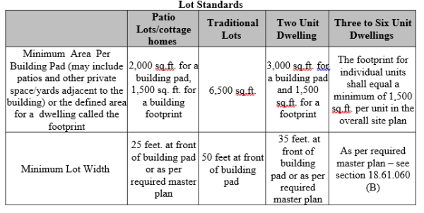
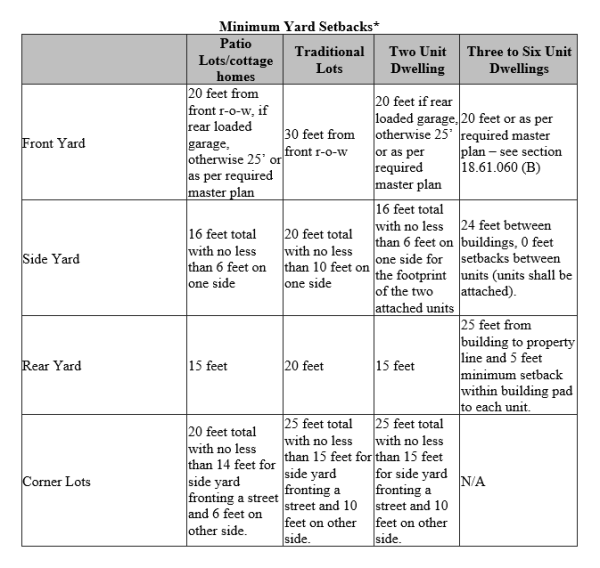
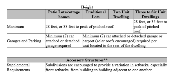 Notes:
18.61.050 Planned Community Zone Process
A. Property can be annexed into the City as the PCZ or rezoned to the PCZ. B. The application for PCZ includes a required Master Plan (Section 18.61.060) which may be submitted in conjunction with the Annexation Application or the Rezone Application, or after an Annexation or Rezone is approved. C. A Development Agreement is required. The required Planned Community Master Plans shall encompass annexed or rezoned areas within the designated PCZ. In the case of multiple master plans for one annexation or rezone area, each parcel shall submit a master plan per Section 18.61.060. D. Applications are available online or at the City offices.
18.61.060 Planned Community Zone Submittal Application Track
Submittal Requirements. The application information, master plan, and draft development agreement shall be submitted to the Planning Director, along with the appropriate fees, for review prior to any hearing for a rezone or annexation. Applications for the rezone, the application requirements for a Master Plan and a development agreement template are available online and at the City offices and are generally covered as follows:
A. Annexation Application (See the Heber City Annexation Policy Plan) or the Rezone Application and General Plan Amendment (See the Heber City Code Title 18). B. Master Plan Package – including the following:
1. Vicinity Map 2. Master Plan – showing entire project concept, densities, land uses, trails, open space, circulation and roads, and other site improvements and development concepts. 3. Phasing Plan – master plan indicating phasing of entire project, with estimated timeframes for development and a chart showing number of units and amenities per phase. 4. Landscape Concept Plan – plan view of features such as: main entry, pocket parks, golf course, neighborhood entry and/or others. 5. Environmental Features Map – showing approximate location of potential wetlands (Army Corps approved delineation preferred); ponds, lakes, streams, canals or other bodies of water; slopes over 30%; potential geological hazards; fault lines; wildlife habitat; and stands of significant vegetation. 6. Proposed Utility Plan – showing utilities available (if any) and proposed easement for new utility services or relocated utility services, and other proposed features such as systems of drainage, sewage and water supply. 7. Proposed Streets – street widths and cross-sections. 8. Architectural Design Guidelines
C. As applicable, a brief written statement from each of the following affected entities indicating the availability of current services, as well as the conditions and the impact of the development on such services:
1. School District(s), 2. Water Service District(s), 3. Sewer Service District(s), 4. Waste Removal and Disposal Service Provider(s), 5. Water Canal Companies 6. Fire Department, 7. Sheriff, 8. EMT Response/Protection Service Provider(s) and, 9. Storm Water Management and Control Agency.
D. A Title Report for the property under the Master Plan provided by a Title Company and dated within 30 days of the date of Annexation Plan Submittal; E. Planned Community Development Agreement shall, at the minimum, include the following:
1. A legal description of the land; 2. A description of proposed density and uses for the project; 3. A copy of the Master Plan package; 4. A description of all Developer exactions or agreed upon public and private dedications and commitments; 5. The Developer’s Agreement to pay specified service provider fees; 6. The form of ownership anticipated for the project Property Owners Association and how the property will be maintained and used; 7. Other specific requirements, rights, and peculiarities pertinent to the project;
F. Affordable Housing Plan.
G. Approval Process for a Rezone, Master Plan, and Development Agreement shall follow the process for a rezone as outlined in Chapter 18.12. For annexations the process shall be as described in Chapter 18.116. Mayor and the Applicant(s) shall sign the Planned Community Development Agreement as presented or as amended by the City Council. The Development Agreement shall be filed for recording with the City and County Recorder’s office at the Applicant’s expense.
H. Once a Planned Community Development Agreement is signed by the Mayor and the Applicant, the project has received Master Plan approval. Only an approved Development Agreement/Master Plan allows an Applicant to proceed with submittal of a Subdivision application. Master Plan approval is valid for two years from the date of approval. If after two years from the date of approval, a subdivision application has not been filed with the City, the Master Plan and Development Agreement is null and void. An extension may be requested by an Applicant and reviewed and approved by the City Council. Extension approvals shall be considered based on material shortages, labor shortages, weather delays, financial issues, or other valid reasons and may generate a reconsideration of the master plan or development agreement.
18.61.070 Subdivision Of Master Planned Land
18.61.080 PCZ Minimum Roadway Standards
18.61.090 Open Space
A. Open space (including buffer zones) are essential parts of the PCZ and shall be designed to serve the anticipated population of the development using the North Village Overlay Zone guidelines. B. A minimum of 40% open space, including the type of open space, proposed locations, and acres shall be identified and required on the Master Plan, except that infill parcels may reduce this to 20% C. Each Master Plan shall identify the type of open space, location, and acres. D. The Master Plan shall identify what is to be considered as open space by using the following parameters as a guide:
1. Waterways, water bodies, man-made water features, wetlands, steep slopes, and other areas to remain undeveloped may be included in the calculation for the open space requirement. 2. Active, non-hard surface recreation areas, such as golf, skiing, hiking, and biking trails may be included in the calculation for the open space requirement. 3. Common park areas with passive (landscaping, lawn areas, picnic, and bench areas) and active areas (soccer fields, baseball diamonds, tennis courts, fishing ponds, playgrounds, park gazebos) may be included in the calculation for the open space requirement, provided they are used for scenic, landscaping or recreation purposes and they are located on land which is accessible and available to all occupants of dwelling units for whose use the common park area is intended. 4. Buffer zones along the property boundaries may be included in the calculation for the open space requirement. 5. Natural, unimproved or non-landscaped areas with passive uses that include trails contiguous to other open space may be included in the calculation for the open space requirement. 6. Parking lots, parking area landscaping buffers, paved roads, service roads, private yards, buildings or structures, required setbacks for buildings or structures, and all subdivided parcels less than one (1) acre shall not be included in the calculation for the open space requirement.
7. If the City requires a deeded right of way to accommodate infrastructure improvements that were not originally anticipated by the Master Plan, the City may reduce the overall open space requirement. However, such a reduction in open space shall not exceed the area or property required to accommodate the infrastructure.
8. Opportunity for Open Space minimum requirements reduction
a. The Planning Commission and City Council may consider reducing the minimum requirement for open space on non-infill parcels which is 40% of the total project area, down to 30%, provided that certain property is developed to provide amenities or facilities, as follows:
(1) Landscaped boulevards; (2) Active and passive open space and trail systems that are open to the general public and provide pedestrian connectivity to other developments or public facilities or as shown on the Parks and Trails Master Plan that are open and available to the general public; (3) Enhancements that improve the land beyond just unimproved acreage; (4) Such as landscaped gateway parks, historic monuments or designations; (5) Improved trail heads; (6) Water features and park like features.
b. For every acre or portion thereof, of enhanced or improved open space pursuant to the above criteria, the developer may be given credit for two acres of open space toward the 40% requirement. Such credit shall restore the 40% open space requirement mandated by the PCZ. c. In no event shall any open space requirement be less than 30% of the total project area.
E. The following factors shall be considered when determining the responsibility for the preservation, maintenance and ownership of open space within the development, consistent with the rights and responsibilities delineated in the development agreement.
1. Compliance with the provisions of the Condominium Ownership Act, Title 57, Chapter 8, Utah Code Annotated, as amended, which provides for the payment of common expenses for the upkeep of the common area and facilities; 2. The developer may retain ownership and responsibility for maintenance of the designated open space, but then shall commit to such responsibility through written agreement with all parties who subsequently acquire ownership of property within the Master Planned development and provide a legally binding assurance for long term maintenance, as approved by the City Attorney; 3. The Homeowner’s Owners Association may retain ownership and responsibility for maintenance of the designated open space, but then shall commit to such responsibility through written agreement with all parties who subsequently acquire ownership of property within the Planned Community development; 4. The open space may be deeded in perpetuity or preserved as a conservation easement as open space to a land trust organization or to the City. If this mechanism is used for agricultural land, an agreement for at least ten years continued agricultural use by the owner or a minimum 10 year lease shall accompany the conservation easement, as approved by the City Attorney. Such agreements shall be recorded at the County.
F. Permanent Protections of Open Space or Agricultural Land:
1. Conservation Easement: All Open Space and/or Agricultural Land shall be permanently restricted from future development by a conservation easement or other method of protection and preservation acceptable to the City. Under no circumstances shall any development be permitted in the Open Space or Agricultural Land at any time, except for those permitted or conditional uses listed herein and approved in conjunction PCZ. All conservation easements, or another acceptable method of protection and preservation of the Open Space or Agricultural Land within a Rural Residential Cluster Subdivision in the PCZ, shall be approved by the City Council and recorded prior to or concurrent with the recording of the final plat for the Subdivision. 2. Terms and Conditions: All conservation easements, or another acceptable method of protection and preservation, shall be in substantially the same form as the standard conservation easement form provided by the City and shall include, at a minimum, the following terms and/or conditions:
a. Legal description of the easement; b. Description of the current use and condition of the property; c. Permanent duration of easement and the non-profit that will hold the easement; d. Remaining uses for the preserved land; e. Maintenance responsibilities and duties; and f. Enforcement rights and procedures.
3. Marking of Open Space or Agricultural Land: Open space land shall be marked at each corner and property line intersection with a minimum 4” diameter x 3’ deep concrete monument provided with an aluminum or brass cap cast or epoxied into the monument. Caps shall be stamped “Heber City Conservation Marker, Do Not Remove”, and an arrow stamped into the cap perpendicular to the defined boundary line and pointing into the preserved open space. Monuments shall be placed such that the top 6” of the monument is above finished grade at the monument location. 4. Grantee: Unless otherwise approved by the City Council, the grantee of a conservation easement shall consist of one of the following acceptable entities which entity shall be qualified to maintain and enforce such conservation easement: land trust, conservation organization, or other governmental entity. 5. Ownership of Open Space Land:
a. Undivided Ownership: Unless otherwise approved by the City Council and subject to the provisions set forth in this section, the underlying fee Ownership of the Open Space or Agricultural Land shall remain in single Ownership and may be owned and maintained by one of the following entities: homeowners’ association, land trust, conservation organization, governmental entity, or private individual. b. Property Not Subject to Subdivision: Property subject to a conservation easement, or another acceptable method of protection and preservation, shall not be further subdivided. c. Owners Association: Open Space or Agricultural Land may be held in common ownership by a Home Owners or other acceptable Owners Association, subject to all the provisions for Owners Associations set forth in State law, the City Code, and the following:
(1) A description of the organization of the proposed Association, including its bylaws, and all documents governing ownership, maintenance, and use restrictions for Open Space Land, including restrictive covenants for the subdivision, shall be submitted by the developer with the final plat application. (2) The proposed association shall be established, funded and operating (with financial subsidization from the Developer, if required by the City in the development agreement) prior to or concurrent with the recording of the final plat for the subdivision; (3) Membership in the association shall be mandatory for all purchasers of property within the Rural Residential Cluster subdivision and their successors in title. (4) The association shall be the responsible party for maintenance and insurance of its Open Space or Agricultural Land under the Final Maintenance Plan for the subdivision; (5) The bylaws of the association and restrictive covenants for the subdivision shall confer legal authority on the association to place a lien on the real property of any member who falls delinquent in dues. Such dues shall be paid with the accrued interest before the lien may be lifted; and (6) Written notice of any proposed transfer of Open Space Land by the Association or the assumption of maintenance for the Open Space Land must be given to all members of the Association and to the City no less than thirty (30) days prior to such event. (7) The owners’ association shall be required to provide a bond or line of credit to the City for the cost of one year of maintenance of property owned by the Association, to be maintained by the Association for as long as the Association owns the Open Space or Agricultural land. (8) In the event of a failure of the owners’ association to maintain the properties in accordance with the requirements of the development agreement, the City shall revoke the owners’ association’s bond, determine an appropriate assessment for the operation and maintenance of the open space and/or Agricultural land, and assess all properties of the Rural Residential Cluster Subdivision on a monthly basis for said maintenance.
d. Private Ownership: A conservation parcel may be owned by a private individual or entity. Such parcels shall have a defined purpose and restrictions recorded in the maintenance plan and comply with this section.
6. Maintenance of Open Space and/or Agricultural Lands:
a. Costs: Unless otherwise agreed to by the City, the cost and responsibility of maintaining Open Space or Agricultural Land shall be borne by the owner of the underlying fee of the Open Space or Agricultural Land or as determined in a development agreement. b. Preliminary Maintenance Plan: A Preliminary Maintenance Plan shall be submitted to the City with the preliminary plat for the proposed preserved land maintenance within the subdivision. This plan shall outline the following:
(1) The proposed Ownership of the preserved Land; (2) The party that will be responsible for maintenance of the preserved Land; (3) The proposed use of the preserved Land and the parcel(s) meets the standards listed within this section; (4) The size of each preserved parcel; and (5) The proposed concept plan for landscaping of an Open Space parcel or the continued agricultural use of the Land.
7. Final Maintenance Plan: The developer shall submit a plan outlining maintenance and operations of the Open Space and/or Agricultural Land and providing for and addressing the means for the permanent maintenance of the preserved land within the proposed Rural Residential Cluster Subdivision application for the subdivision. The developer shall provide a final maintenance plan with the final plat and the plan shall contain the following:
a. Ownership agreements for preserved Land; b. A description of the use of the preserved Land and how that use complies with this section; c. The establishment of necessary regular and periodic operation and maintenance responsibilities for the particular type of preserved land (e.g., lawns, playing fields, meadow, pasture, wetlands, stream corridors, hillsides, cropland, woodlands, etc.); d. The estimated staffing needs, insurance requirements, and associated costs, and define the means for funding the maintenance of the preserved Land, and the operation of any common facilities located thereon, on an ongoing basis, including means for funding long-term capital improvements as well as regular yearly operating and maintenance costs; and e. The landscaping plans for parcels that will be owned by an owners association or by the City. f. Approval: The Final Maintenance Plan must be approved by the City Council prior to or concurrent with final plat approval for the subdivision. The Final Maintenance Plan shall be recorded against the property within the subdivision and shall include provisions for the City's corrective action rights as set forth herein. Any changes or amendments to the Final Maintenance Plan must be approved by the City Council.
8. The developer shall offer an approved letter of credit, bond or escrow for all proposed improvements and must complete all proposed open space improvements within the first three years of approval. If a designated open space parcel is planned to be maintained by a single property owner, the developer shall maintain that property until title is transferred to a new property owner. 9. Failure to Maintain: For all open space designated under the terms of this Ordinance, including privately held Open Space or Agricultural Lands, the responsible party for the maintenance of the preserved Land in accordance with the terms of this ordinance, the approved maintenance agreement, any conditional use permits, business licenses or any other agreements between the City and the responsible party, or the operation of any common facilities located thereon fails to maintain all or any portion of the preserved Land or common facilities in accordance with the aforementioned agreements and ordinances, the City may assume responsibility for the maintenance and operation of the Open Space or Agricultural Land. If the City assumes responsibility under this paragraph, any remaining development escrow or bond funds may be forfeited, liens for maintenance costs shall be assessed as described herein, and any permits, licenses or operating agreements may be revoked or suspended by the City in the City’s sole discretion. The owner shall not impede the City in their efforts to maintain the open space. 10. Corrective Action: The City may enter the premises and take corrective action, including extended maintenance. The costs of such corrective action may be charged to the property Owner and may include administrative costs and penalties. Such costs shall become a lien on said properties. Notice of such lien shall be filed by the City in the county recorder's office. The maintenance plan and all other documents creating or establishing any Association or conservation organization for the property shall reference the City's corrective action authority set forth herein and shall be recorded against the property. 11. Implementation and Maintenance: The developer of the subdivision shall fund implementation and maintenance of the conservation easement until such time as the control of the easement is transferred to the long-term manager. The developer shall address implementation, development, maintenance and transfer procedures in the development agreement, as applicable. 12. Maintenance Access: The developer of the subdivision shall provide sufficient maintenance access from a dedicated right-of-way to all preserved Land and constrained and sensitive lands within the Rural Residential Cluster Subdivision. 13. Changes in the project’s dedication of open space may only be implemented through a Master Plan and development agreement amendment process.
18.61.100 Related Provisions
Chapter 18.12 Administration Chapter 18.08 Definitions Chapter 18.108 Conditional Use Permits Chapter 18.72 Off Street Parking and Loading Chapter 18.103 Sign Regulations Chapter 18.78 Lighting Chapter 18.174 Enforcement Chapter 17 Subdivisions Heber City C-2/C-4 Zone Design Standards and guidelines