Heber City City Zoning Code
18.21 North
Village Overlay District NVOZ
18.21.010 General Provisions
Click to view the General Provisions of the North Village Overlay District Code.
1.0 General Provisions
18.21.020 Land Uses
18.21.030 Buildings
18.21.040 Streets
Click to view Streets of the North Village Overlay District Code and to see all illustrations and graphics.
18.21.050 Park, Trails, And Natural Lands Preservation
Click to view Park, Trails, And Natural Lands Preservation of the North Village Overlay District Code.
1. Overview
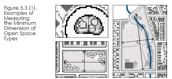
This section establishes the design standards for open space, parks, and trails. These standards include general character, typical size, frontage requirements, and typical uses.
2. General Requirements (All tables and figures for this section are found on pages 47-55)
The following objectives and design standards shall be implemented in the design and construction of required community spaces and trails:
(1) Integration. They are integrated into neighborhoods.
(2) Activation. They activate the built environment in a way that promotes activities in key locations and promotes community interaction and economic vibrancy.
(3) Accessibility. To be counted meeting the required percentages, parks and open space shall include public access and be accessible by walking and cycling; all parks, trails, and open spaces shall provide public access from a vehicular right-of-way.
(4) Continuity. Trails shown on the Community Design Map shall be installed with each phase that includes the mapped trails. Connections to existing or planned trails, parks, and open spaces shall be made when the park or open space abuts an existing or planned trail right-of-way or other civic open space or park. Trails should be internally and externally connected to Master Planned trails. Dead end trails require a negotiation with the City Council. Refer to the Heber City Parks Master Plan, the Community Design Map and section 15(b) and 16 below.
(5) Location. Parks and open spaces shall be platted as a lot.
(6) Intermittent and Open Water Bodies. All water bodies, such as lakes, ponds, pools, creeks, and streams, within a park or open space shall be located at least 20 feet from a property line to allow for pedestrian and bicycle access as well as a landscape area surrounding the water body.
(7) Ownership. Parks, trails and open spaces may either be publicly or privately owned.
(8) Parking Requirements. Parking shall be reviewed and approved by the zoning administrator. Where parking is required for the park to function, it may be counted as part of the open space calculation.
(9) All dwelling units shall have access to at least one local park or open space within one-quarter mile and one neighborhood park within a half mile as measured from property lines.
(10) All dwelling units shall have at least one point of trail system access no greater distance than one-half mile away as measured from property lines.
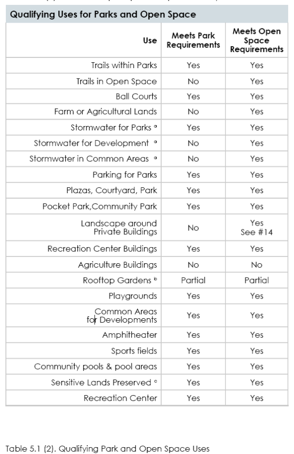
(11) Open space is defined as land for the purpose of conservation, preservation, agriculture, resource enhancement, formal and informal recreation, enhancing value to adjacent parks or preserves, or otherwise providing a buffer to adjacent properties. Qualifying uses can be found in Table 5.1 (2).
(12) A park is defined as a non-commercial, not-for-pro t public facility for general community use. Parks may include programming and facilities that support active and passive recreation. Qualifying uses can be found in Table 5.1(2). Parks may be owned and maintained by a home owners association, improvement district, city or county.
(13) A trail is defined as a path physically separated from motor vehicle traffic by open space, landscape, or a barrier for non-motorized travel, such as walking, jogging, biking, skateboarding, or other similar modes of transportation.
(14) Required stormwater detention and/or buffer areas may
be counted as part of the open space percentage
requirement, as per City Stormwater requirements.
a. See 5.0 Stormwater and #14
b. Fifty percent of rooftop garden space may be applicable Park Space square footage requirements. The rooftop garden space must be accessible to residents of the project.
c. Fifty percent may be counted towards Open Space requirements.
100% may be counted with enhancements and public access.
(15) Concept plan submittals must include the following:
(a) Parks Plan. Must show location and size of planned parks.
(b) Parks Walking Distance Plan. Must show residential buildings within walking distance of each park.
(b) Trails Plan. Must show existing and proposed trails and their connections to key destinations, such as schools, parks, and other community facilities; the intended uses/modes of travel for each segment of trail; and the material and width of trails. Trails shall include all trails shown on the Community Design Map as part of the subject property responsibility for construction. All trails to be constructed as per 17.30 and all trails constructed within a project shall be constructed by a licensed trail contractor. Paved trails shall meet ADA standards. No existing trails shall be relocated without City Council approval.
(c) Open Space Plan. Must show location, size, and function of open spaces.
(d) Project-Level Maintenance and Management Plan. Must designate the parties responsible for maintenance, the maintenance methods, the budget, and define the areas to be maintained.
(16) Whenever possible, trails should be part of a continuous system that connects but may dead end into, schools, parks, community centers, UVU facilities, recreational centers, villages, libraries, and other key destinations. Neighborhood sidewalks should connect with trails but do not count as trails, unless designated using the appropriate street type and width or to create a loop/connection. Dead end trails are allowed to property lines, if the trail is specified on the Community Design Map, however a street connection/side trail is required to improve trail connections and function.
(17) One bench is required per one-quarter mile of continuous trail spaced no more than one-quarter mile apart. Bench design shall be reviewed and approved by the zoning administrator.
3. Parks and Open Space Percentage Requirements
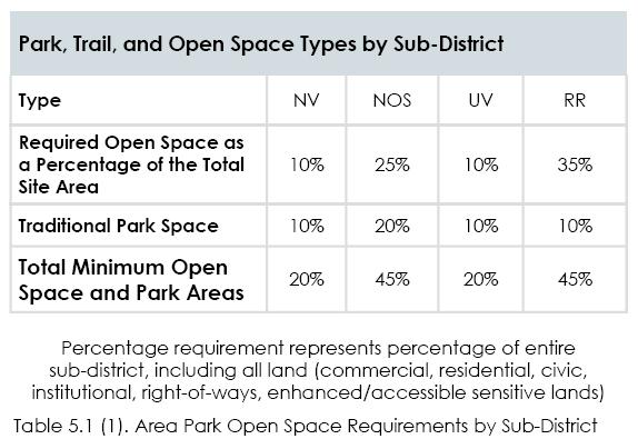
(1) Open space proposed through an MDA or site plan shall generally comply with the open space types prescribed in this chapter and meet the minimum required percentages by subdistrict zone (Table 5.1 (1)).
(2) Open space amenities that are owned by a homeowners association shall be maintained by the homeowners association. Open space and traditional park percentages are required as per Table 5.1(1). Open spaces and parks smaller than 1 acre shall be an HOA responsibility with a public easement placed thereon, unless modified by an MDA or AA.
(3) Where development project boundaries include two subdistricts, park and open space requirements may be arranged within the project in a flexible manner, as long as the total requirements of each sub-district are met within the overall development and are approved in a master development agreement.
4. Definition of Requirements
The following further explains or defines the requirements included in sub-sections 5.6 through 5.16 for each park/open space type. Refer to each table for the specific requirements of each open space type. Developments shall use the defined types of parks and open spaces, described herein.
(1) Size. (See Figure 5.1 (1) for overall percentage requirements.)
(a) Minimum and Maximum Size. The minimum and maximum size of the park/open space type is measured within the parcel lines of the property, as required by the park type tables.
(2) Minimum Percentage of Vehicular Right-of-Way Frontage Required. The minimum percentage of the civic park/open space perimeter, as measured along the outer parcel line, that shall be located directly adjacent to a vehicular rightof- way, excluding alley frontage. This requirement provides access and visibility to the open space.
(3) Adjacent Parcels. Parcels directly adjacent to, as well as across the street from, a park/open space.
(a) Frontage Orientation of Adjacent Parcels. The preferred orientation of the adjacent parcels’ frontages to the open space. Front, corner, side, and rear refers to the property line either adjacent to the park/open space or facing the park/open space across the street.
(4) Improvements. The following types of development and improvements may be permitted on a park/open space type. Required improvements are further detailed in the Parks Master Plan.
(a) Designated Sports Fields Permitted. Sports fields, ball courts, or structures designated for one or more particular sports, including, but not limited to, baseball fields, softball fields, soccer fields, basketball courts, football fields, tennis courts, pickleball courts, climbing walls, and skate parks, are permitted.
(b) Playgrounds Permitted. Playgrounds include a defined area with play structures and equipment typically used by children, such as slides, swings, and climbing structures. Play structures shall be constructed to accomodate 15% of the anticipated population within .5 miles.
(c) Fully Enclosed Structures Permitted. Fully enclosed structures may include such uses as park offices, maintenance sheds, community centers, and restrooms.
(i) Maximum Area. For some open space types, fully enclosed structures are permitted, but limited to a maximum building coverage as a percentage of the open space area.
(ii) Semi-Enclosed Structures. Open-air structures, such as gazebos, are permitted in all open space types.
(d). Maximum Impervious and Semi-Pervious Surface Permitted. The amounts of impervious and semipervious coverage are provided separately to allow an additional amount of semi-pervious surface, such as permeable paving, above the impervious surfaces permitted, including, but not limited to, parking facilities, driveways, sidewalks, paths, and structures as permitted.
(e) Maximum Percentage of Open Water Body. The maximum amount of area within an open space type that may be covered by an open water body, including, but not limited to, ponds, lakes, and pools.
2020-42
18.21.010.1.1 Enabling
1.1 Enabling
Any new development, exterior remodeling covering more than 50% of the building, or building expansions exceeding 30% of the
gross square footage of the existing building, shall conform to the NVOZ. Conformity shall not be required for maintenance, exterior
painting, accessory buildings, or interior remodeling of a building. New signs or sign replacements shall also comply with the NVOZ.
18.21.010.1.2 Title
Title
This Code shall be known and may be cited as the “North Village Overlay Zone” (NVOZ) or the “Code.” The NVOZ area is
composed of four sub-districts – the North Village (NV), Neighborhoods with Open Space (NOS), University Village (UV), and the
Rural Residential (RR).
18.21.010.1.3 Purpose And Intent
1.3 Purpose and Intent 1. This Code is adopted for the purposes of: protection of the environment, conservation of land, energy and natural resources, reduction in vehicular traffic, health benefits of a pedestrian environment, to maintain clean air, preservation of natural open space, connected trail systems, education and recreation, reduction in sprawl, support for property rights and values, and improvement of the built environment through the creation of a sense of place. 2. To provide a mixture of housing types and land uses in a compatible setting and a true mixed use environment.
3. To assure quality development. Higher densities and flexible uses are anticipated in the North Village Overlay Zone and shall
be defined through high-quality materials, architecture, landscaping, open space, and trails. Architecture and materials must
provide a sense of place that is unique to Heber City and maintains community values as defined in the Heber City General
Plan. Architecture should be thoughtful and complimentary as a gateway to the community. The streetscape should be more
compatible with a rural appearance and a mountain environment.
4. To create interconnected open space and pedestrian systems which also connect to backcountry trails
5. To implement the vision and principles of the Envision Heber 2050 General Plan.
6. For many years the development area east of US 40 has been suggested to play a role in the preservation of the area known
as the “North Fields”, west of US 40. It is the intent of this Code to promote preservation. The base density ranges apply (see
2.1.1)but may be separately negotiated through an annexation or development agreement that requires the payment of an
additional preservation fee per ERU.
18.21.010.1.4 Organization And Guiding Principles
1.4 ORGANIZATION AND GUIDING PRINCIPLES
a. The Sub-Districts – General Descriptions
1. North Village (NV)
a. A town center located at the major crossroads of Highway 40 and Highway 32, growth is anticipated to exceed many other areas of Heber due to the numerous developments occurring in both Summit and Wasatch Counties, including evolving ski resort destinations. This crossroads is logically one of the areas to receive much development pressure and will likely include major commercial, restaurants, entertainment, workforce housing and hospitality uses, paired with compact residential neighborhoods. Trail connections to the mountains and the lake-to lake trail, and avoiding the appearance of strip commercial is paramount and includes roadway buffering and effective transitions to the adjacent sensitive lands and agricultural Fields.
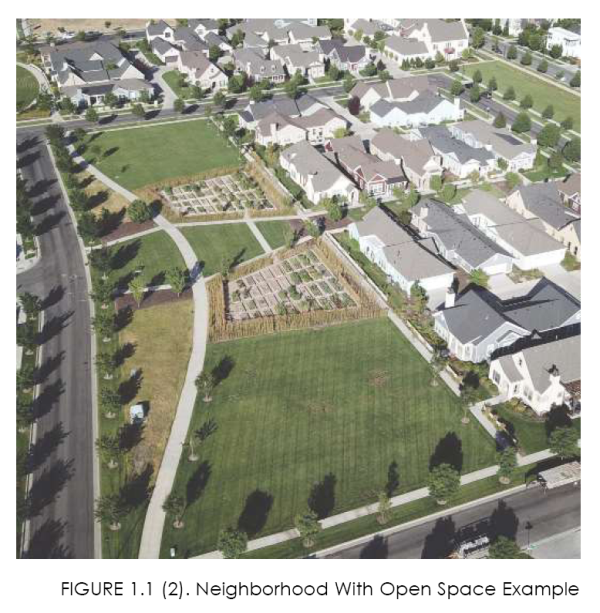
2. Neighborhoods with Open Space (NOS)
a. Neighborhoods with open space are walkable communities that blend a variety of housing options and shared open space amenities. NOS will be within walking distance of a village where residents can access services and goods that are needed on a regular basis.
b. Quality building materials and architectural standards should enable a range of housing types to blend seamlessly into neighborhoods.
c. Open space amenities should be a central feature in a neighborhood and may include parks, plazas, trails, community gardens, natural open spaces, or other space that can be accessed by residents. Quality open space amenities include long-term management and maintenance plans.
d. Streetscape standards will ensure walkability with connections to centers and to trail systems within the area.
3. University Village (UV)
a. Located near the south end of the North Village neighborhoods and including the open areas further south to the Wasatch
Commons apartment complex, the Utah Valley University Wasatch Campus and its environs have the potential to become the
southern bookend to the North Village neighborhoods. The area currently includes the campus and signi cant vacant land before
expanding out to several proposed developments. All sides of the campus have the potential to provide supportive development,
which is critical to the success of the school. Supportive development could include additional affordable housing for the student
population, limited retail and personal services, hospitality, and incubator businesses such as high tech and trades which could be
encouraged in the area through a Flexible zoning philosophy.
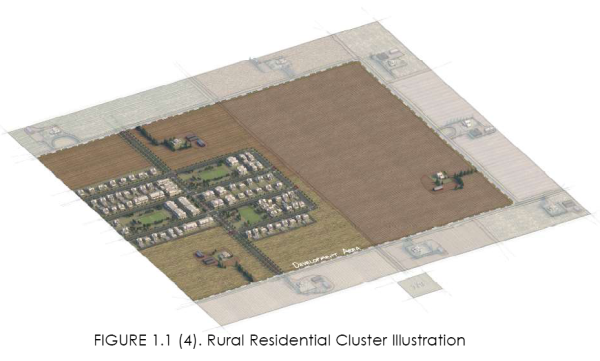
4. Rural Residential Clusters (RR)
a. This sub-district clusters housing on 25% to 70% of the development parcel, while permanently preserving the remainder as open space. This option is best employed where larger acreages exist, so preserved open space is large enough to be viable for visual relief, animal habitats, trailheads, equestrian use, mountain biking, in its natural state. Development may contain larger lot homes as well as clustered, small lot and townhouse housing.
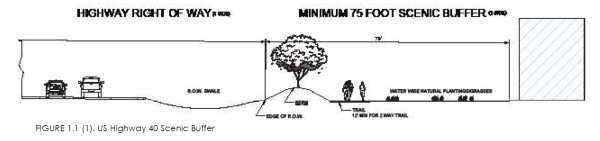
5. Transitions, Edges, and the Scenic Buffer
a. All development along the east side of US Highway 40 and on the south side of SR 32 east of US 40, must be separated from traffic and include a scenic buffer, which includes landscaping, mounding and an asphalt 12-foot multi-use path. The scenic buffer shall not be uniform in width, and may increase in width where larger areas of storm water detention are required. Where located to the east of the powerlines, it shall have a minimum width of 50’. North of the University Blvd., where the powerlines turn east, the corridor shall be 75’ wide, measured from the ROW. Near River Road, insuf cient space is available, the scenic buffer shall taper to 25’as per the approximate distance shown on the Community Design Map.
b. The scenic buffer shall be designed to reflect the North Village Overlay Zone open space theme (natural and enhanced landscaped areas) (unless reduced as per “f” below) with no hard surface except for the path. It shall undulate in width to accommodate potential storm water retention. Up to 50% of the buffer may be disturbed ground but replanted with a combination of irrigated deciduous and coniferous trees, and boulders/inert materials.
c. Storm drain detention areas may encroach within the required width of the US Highway 40 scenic buffer, but shall not replace or eliminate the required mounding and multi-purpose trail. Where storm water detention is incorporated into the scenic buffer it shall be designed as an enhancement to the natural appearance of the landscaping.
d. Vehicular Screening Requirements - parking lots, drive-up windows facing US 40, loading docks, service bays, and gas pumps must screened from traffic with mounding, or retaining walls a minimum of 3 feet in height, and/or four-season vegetative screens of 3 feet in height, creating a solid hedge after 3 years of growth.
e. Along SR 32, east of US 40, a pedestrian path and bike path is required adjacent to the highway. Where grades allow, such paths shall be separated from the highway an average distance of 20 feet. Areas between the paths and the highway shall be landscaped with native plants, a wildflower mix, and hardy shrubs.
f. Encroachment - parking lots may encroach 10’ where the scenic buffer is adjacent to the powerlines, 20 feet within the required 75-foot cross section areas, and no encroachment is allowed where the buffer is less than 40’ but shall not replace or eliminate the required mounding and multi-purpose trail. If incorporated into the buffer, parking lots must be visually as per “d.” above (see diagram above) unless they are raised above the Highway grade by 10 feet. The berm must be landscaped to create a minimum 80% screen of the parking lot. Parking lots may only encroach for 60% of the property frontage. Where slope issues exist adjacent to US Highway 40, retaining walls may be utilized. When such walls are over 6 feet in height, an irrigated landscaped terrace, at least 3’ wide, consisting of shrubs and groundcovers (a combination of live groundcovers/impermeable mulches, at a minimum of 4 inches in depth) at 6-foot height, is required before the continuation of the wall to a higher elevation. In addition, the buffer may also be reduced to 50’ where shallow depth properties or topography impact site design. Such properties shall enhance the buffer landscaping by doubling the amount of native landscaping, especially the planting of Scrub Oak and Maple, sage brush, aspens, up to 25% evergreen trees, and other native plants.
h. Garbage dumpsters shall not be placed within the scenic buffer, nor any front or side yard visible from the adjacent street.
18.21.010.1.5 The North Village Overlay Zone Development Principles
1.5 The North Village Overlay Zone Development Principles
a. All neighborhoods shall be compact and include clustered developments.
b. All neighborhoods shall be pedestrian-oriented with a system of open spaces and connected trails.
c. The ordinary shopping, educational, and recreation activities of daily living should be accessible within walking distance of most dwellings.
d. Interconnected networks of thoroughfares should be designed to disperse traf c and reduce the length of automobile trips. Grid networks of streets/blocks are required in all sub-districts, though areas with steeper terrain are permitted exceptions (see Table 4.2(1). Street systems should be designed to minimize the need to access a state highway. Potential park and ride locations near the future semaphore locations on US 40 should be identi ed as well as potential transit stops in the Villages.
e. In areas of steeper terrain, cul-de-sacs are permitted (see Table 4.2(1). When used, cul-de-sacs should be located adjacent to pedestrian paths and/or trails to assure connectivity within the neighborhood.
f. Within neighborhoods, a range of housing types and price levels should be provided to accommodate diverse ages, life stages, and income.
g. Retail centers shall be located within the villages (NV and UV), as per the Community Design Map, with good pedestrian connectivity to adjacent land uses.
h. Retail buildings should be placed adjacent to the street with parking located behind the buildings.
i. Commercial office development should be embedded in the NV and UV sub-districts.
j. A range of open spaces, including parks, squares, plazas, and playgrounds, should be distributed within neighborhoods and the villages (see Section 5.0).
k. Buildings and landscaping should contribute to the positive appearance of streets and street frontages by creating an attractive public realm with the streetscape being framed by attractive buildings.
l. Design of streets and buildings should reinforce safe environments, but not at the expense of accessibility.
m. Architecture and landscape design should grow from local climate, topography, history, local materials, and building practice.
n. To the greatest extent possible, buildings should provide state of-the-art energy efficiency. Net zero buildings are encouraged.
o. Building types, styles, and uses should present a recognizable theme that clearly relates to the NVOZ. Commercial, including retail, office, research and development buildings, should be designed to smoothly transition to adjacent residential structures, sharing common features and materials.
18.21.010.1.6 Process And Submittal Requirements
1.6 PROCESS AND SUBMITTAL REQUIREMENTS
The following establishes the submission process for development in the NVOZ.
1. Master Development Agreement (MDA) or Annexation Agreement (AA). For properties with more than 5 acres, an MDA and/or AA is required. The City shall provide an MDA format that generally covers, as a minimum: an explanation of the project concept, proposed land uses, a conceptual site plan including block lengths, conceptual building elevations/proposed materials, open space, parks, and required trails from the Community Design Map, requested densities, outreach to non-Heber service providers (including an assurance of water availability/will serve letters for each development phase, through NVSSD), streets, sensitive lands analysis(including a wetland delineation if appropriate), and a conceptual storm drainage system using low impact development (LID) techniques that meet the City stormwater plan and City Stormwater requirements/best practices. Any delineated wetland(s) deemed moveable by ACOE, shall be mitigated on site or on an adjacent property. The MDA or AA shall be reviewed by City staff and then placed on a Planning Commission agenda for recommendation to the City Council. The City Council, in a public hearing, shall review, suggest modifications, if needed, and approve, approve with modifications, or deny with reasons related to unmet NVOZ standards or an inability to service the area.
2. If the above process results in an approved MDA and/or annexation agreement, it shall constitute a conceptual plan approval, which may be amended during the final plat or final site plan process. If no MDA/AA is required, a conceptual plan, including the information required above shall be processed with staff as the initial development processing step.
3. Preliminary Plat or Permitted Use Site Plan. On an application form provided by the City, the proposed development shall provide detailed plans suf cient to address design issues, engineering, and utility requirements of the City and associated agencies. Such plans shall be reviewed by staff, updated as needed after the staff review, and placed on the Planning Commission agenda for preliminary approval, for recommendation to the City Council. Such plans shall cover in greater detail the MDA/AA required elements, include geotechnical reports, slope (contours at minimum 2-foot intervals), grading and drainage plans, development constraints, street types and locations, landscaping, proposed parks/plazas, open spaces/ proposed land to be dedicated to the City, HOA maintenance responsibilities (if any), architectural theming for structures, site lighting, anticipated signs, a land use table providing acreage and percent values, and other information required in the application form, available from the Community Development Department. The information required is intended to provide a full understanding of the development under the provisions of the NVOZ.
4. The Planning Commission shall make a detailed decision on the preliminary plat or site plan as submitted, including any modifications. The preliminary plat or site plan becomes the final plat or site plan when staff is satisfied that any requested changes have been correctly resolved. Staff shall manage the process to final plat completion.
5. Final Plat or Final Permitted Use Site Plan. After a completed application form and required information is submitted, final plat approval shall be a staff responsibility for any application initiated with an MDA or an AA. Final plat or site plan requirements will be found on the application form.
6. MDA/AA Modifications. If the above approval process suggests revisions to the original conceptual MDA, changes agreeable to the City and the developer shall be formally adopted as part of a City Council meeting.
7. The Heber City Subdivision Ordinance, Title 17, the Zoning Ordinance, Title 18, and associated standards, processes and requirements, will govern where this Code is silent. The following Heber City adopted ordinances are incorporated within the Code in their entirety:
• Title 17.16 General Subdivisions Procedures • Title 17.20 Plans • Title 17.44 Platting • Title 17.52 Guarantee of Performance • Title 8.72 Off-Street Parking and Loading • Title 18.104 North Village Signs
8. Commencement of Work. When the proper assurances have been processed, site grading and public improvements may begin.
9. Building permits may be issued subsequent to plan submittals, including building elevations and material selections, agency approvals, and sufficient access acceptable to the Fire Department. All application forms and associated requirements are available online and at the Community Development Department, including a standardized Master Development Agreement. Where there is a conflict between the standards of this Chapter and differing Codes or other City Standards, this Chapter shall prevail, unless specifically stated otherwise in this Code or by an MDA/AA.
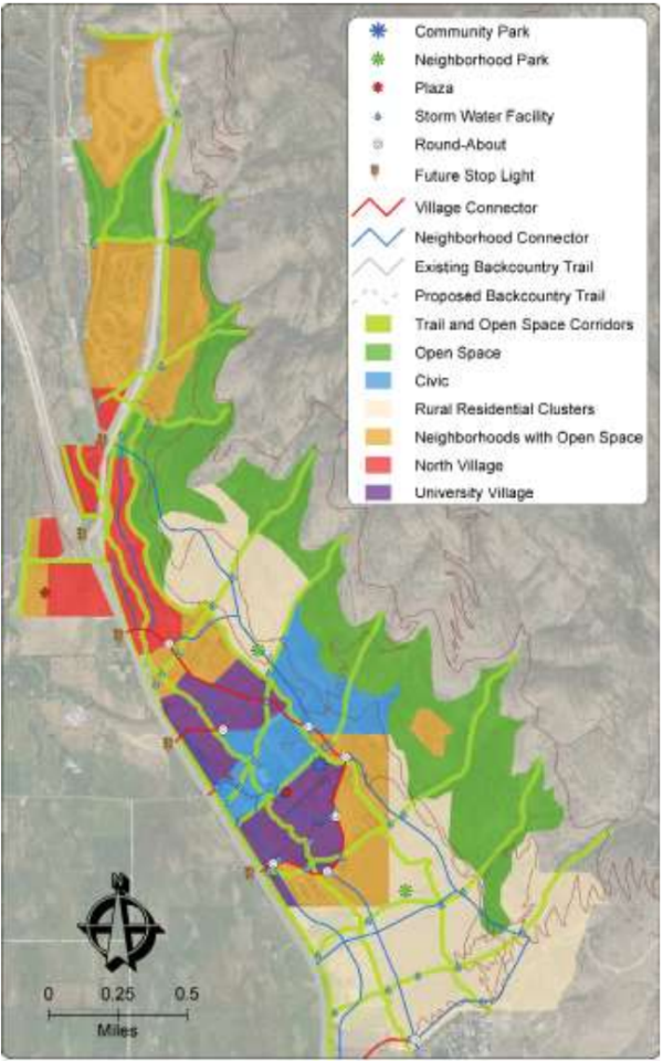
18.21.020.2.1 Community Design Map
2.1 Community Design Map
a. The NVOZ boundaries and sub-districts are established as shown on the Official Heber City Zoning Map. The zoning map is the official map for the North Village Overlay District. The Community Design Map and all notations, references, and other information shown thereon shall be and hereby are made a part of this code by reference as set forth herein. The Community Design Map becomes the concept plan for the NVOZ area and has requirements associated with it. Alignments for many of the map features are not intended to be exact. b. Amendments and changes to the Community Design Map shall follow the requirements outlined in Title 18. c. The Heber City Council may, after a public hearing is held and a recommendation provided by the Planning Commission, consider revisions of the zoning map and/or Community Design Map, to include all changes to date and take the place of the original map which is a part of this code. d. Regardless of the existence of purported copies of the “Official Zoning Map, Heber City, Utah” which may, from time to time, be made or published, the Official Heber City Zoning Map in the Community Development office shall be the final authority for the sub-districts in the North Village Overlay Zone, with copies available in the city recorder’s office. e. The Community Design Map below includes important information about the NVOZ area. It includes the major street network, gullies to be preserved, open spaces, trails, trail heads, and the scenic buffer. This more detailed information is provided to assure general conformance to the principles of the Heber City General Plan and the concepts discussed by property owners in the area.
Figure 1.5 Community Design Map
2.1 Land Uses
| LAND USES: NORTH VILLAGE OVERLAY ZONE (REFER TO COMMUNITY DESIGN MAP) | |||||
| Use | UV | NV | NOS | RR | Limitation |
Accessory | |||||
Attached and Detached Accessory Dwelling Unit | P | N | P | P | see ordinance 18.108.110 |
Accessory Building | P | P | P | P | see ordinance 18.68.60 |
Agriculture | |||||
Farming/Ranching/Grazing/Bee Keeping | P | P | P | P | see ordinance 18.68.135 |
Home Child Care | |||||
Up to 12 Children | P | N | P | P | see ordinance 18.86 |
Educational / Religious | |||||
Church/Cemetery | P | P | P | P | |
Charter and/or Private School | P | P | P | P | |
Public Schools | P | P | P | P | |
Commercial: Office/Business | |||||
Home Occupation | P | N | P | P | Allowed in existing homes on in NV. See ordinance 18.108.020 |
Minor Manufacturing in a Craftsman Industrial Building | P | N | N | N | Less than 50% of the building |
Radio Station (Less than 10,000 SF) | P | P | N | N | |
Business Services | P | P | N | N | |
Personal Services | P | P | N | N | Excludes pay day loans and check cashing |
Financial Institution | P | P | N | N | Excludes pay day loans and check cashing |
Professional Offices | P | P | N | N | Less than 30,000 SF footprint |
Commercial: Retail/Leisure | |||||
General Commercial | C | C | N | N | Less than 60,000 SF footprint |
Bed & Breakfast | P | P | P | P | See ordinance 18.108.034 |
Recreational Vehicle Parks | N | P | N | N | |
Hotel/Hospitality/Lodging | P | P | N | N | |
Grocery | P | P | N | N | Maximum size 100,000 SF |
Neighborhood Store/Shop | P | P | P | N | Less than 5,000 SF and only on prominent corners in NOS |
Neighborhood Shops | P | P | N | N | Less than 12,000 SF. Excludes pawn shops. |
Dining: Restaurants with or without Alcohol | P | P | N | N | |
Dining: Fast Food | P | P | N | N | Drive-thru only allowed to the rear of a building with no car stacking in front. |
Outdoor Markets, Sidewalk Vendors, Food Trucks | P | P | N | N | |
Gas/Convenience Store | P | P | N | N | |
Cinema, Live Theatre, Amphitheater | C | P | N | N | Up to 4 screens |
Entertainment/Commercial Recreation | P | P | C | N | |
Enclosed Climate Controlled Storage Rentals | C | N | N | N | First floor facades facing and visible from a street shall include commercial use, different than an office associated with the business |
Figure 2.2 Land Uses 2
| LAND USE: NORTH VILLAGE OVERLAY ZONE (REFER TO COMMUNITY DESIGN MAP) CONTINUED | |||||
USE | UV | NV | NOS | RR | Limitation |
Commercial: Retail/Leisure - continued | |||||
Payday Lenders, Paw Shops, Tattoo Parlors, Smoke Shops, and Sexually Oriented Businesses | N | N | N | N | |
| Mixed use ( Commercial/Office) | P | P | N | N | |
| Structured Parking | P | P | N | N | First floor commercial or office wrap for street facing facades in NV and shall not occupy street frontage in UV |
MUNICIPAL/CIVIC/PUBLIC SERVICE | |||||
Cemetery | N | N | P | P | |
Recreational Facility | P | P | P | P | |
Public Safety Facility | P | P | P | N | |
| Utility Substation | P | P | P | P | Shall include walls and landscaping |
Utility (Minor) | P | P | P | P | |
Recreation Park | P | P | P | P | |
Open Space | P | P | P | P | |
RESIDENTIAL | |||||
Apartment | P | N | N | N | |
Single Family Detached | P | N | P | P | |
Attached (Townhouse) | P | P | P | N | Clustering and open space required |
Live/Work Units | P | P | P | P | NOS and RR only fronting on a major collector road |
Condominiums (Less than 16 Units) | P | P | P* | N | Clustering and Open Space required |
Condominiums (Greater than 15 Units) | P | C | C* | N | Clustering and open space required |
| Workforce Housing | C | C | N | N | Developments employing over 50 persons shall through a DA provide on-site employee housing |
Mixed use (Commercial/Residential) Mixed use (Commercial/Office) | P | P | P | N | Clustering and open space required; In NOS only allowed on mountain connector street. |
Assisted Living | P | P | P | N | |
Senior Housing | P | P | P | P | |
Residential Facility for Disabled Persons | P | P | P | P | See ordinance 18.68.601 |
TELECOMMUNICATIONS | |||||
Telecommunication Facilities | P | P | N | N | Stealth only. See ordinance 18.110.11 |
| N - Not allowed | P - Permitted | C- Conditional Use | *Not allowed as stacked flat building types |
18.21.020.2.2 Density
2.2 DENSITY 1. Base Sub-District Density Allocation Per Gross Acre: Overall property averages are subject to any Master Development Agreement (MDA) or Annexation Agreement (AA) documentation or any previously formal entitlements from approved plans for this particular property from Wasatch County government. Such agreements may include North Fields preservation requirements or the payment of fees for open space/agricultural land preservation.
1. NV: 4.5 ERUs per gross acre base density 2. NOS: 3.5 ERUs per gross acre, clustering required. 3. UV: Six ERUs per gross acre base density 4. RR: Two ERUs per gross acre, clustering encouraged.
These densities are essentially ranges that not all properties will be able to achieve. They are contingent on site design considerations, sensitive lands avoidance, City Stormwater Standards, water availability, as well as Federal, State, and local service providers/stakeholders processes and approvals, All development/ERUs may be subject to a negotiated preservation fee paid at the time of recording of any plats, in return for the increased flexibility provided for in this ordinance. As part of the overall residential density calculation, commercial ERUs (.86 ERU per every 2000 sq ft) shall be included in the residential density calculation.
2. ERU Density Definitions
| ERUs | ||
| Configuration | Notes | ERUs |
Hotel or Motel Room, RV Pad, Small Studio or Student Housing Unit | Not to exceed 500 square feet | 0.25 |
One Bedroom: Hotel Room, Apartment or Condo | Not to exceed 800 square feet | 0.33 |
One or Two Bedroom: Apartment, Townhome, Cottage Home or Condo | Not to exceed 1,200 square feet | 0.50 |
Apartment, Condo or Townhome | Not to exceed 1,600 square feet | 0.75 |
All Other residential Uses | Detached Single-family and other residential units over 1,600 sf | 1.00 |
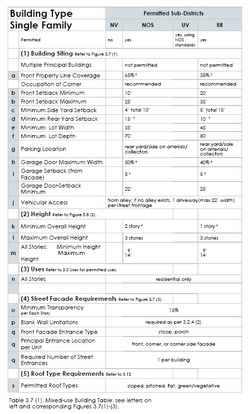
18.21.030.3.1 Introduction To Building Types
3.1. Introduction to Building Types 1. Introduction The building types detailed in 3.0 Building Types outline the required building forms for new construction and renovated structures within the districts defined in Sections 1.0 and 2.0. 2. General Requirements All building types must meet the following requirements:
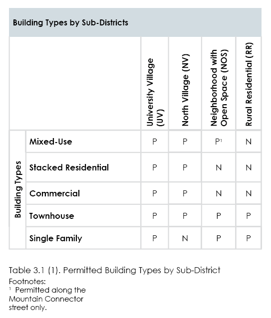
(1) Sub-Districts. Each building type shall be constructed only within its designated sub-districts. Refer to Table 3.1 (1) Permitted Building Types by Sub-Districts. (2) Uses. Each building type can house a variety of uses depending on the sub-district in which it is located. Refer to 2.0 Uses for uses permitted per district. Some building types have additional limitations for certain uses. (3) No Other Building Types. All buildings constructed must meet the requirements of one of the building types permitted within the zoning district of the lot. Civic and religious buildings should be designed with these standards in mind to be compatible with surrounding development. (4) Permanent Structures. All buildings constructed shall be of permanent construction without a chassis, hitch, wheels, or other features that would make the structure mobile, unless otherwise noted. (5) Accessory Structures. See ordinance 18.68.066.
(a) Detached accessory structures shall not exceed the height of two stories (27 feet) and shall not exceed 120 square feet
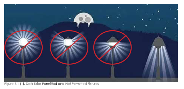
(6) The use of a monotonously consistent template or repetitive architecture on a number of residential units in proximity to one another is not allowed. For single family detached buildings, no more than two identical or nearly identical buildings shall be located next to each other. For attached residential buildings, mixed use, and stacked flats, no more than four adjacent/grouped buildings shall have the same exterior architecture and no more than 2 identical buildings facing a street. As this consideration depends on a degree of aesthetic judgment, the issue shall be reviewed by staff on a project by project basis and shall consider the many facets of a building’s quality, as described in this chapter and 3.1.5. (7) Dark-Sky Lighting Standards. See chapter 18.78 for general provisions, however the NVOZ requires: All outdoor lighting fixtures shall be downward directed and fully shielded. Such lighting fixtures shall not emit light above a 45 degree angle. The more directed towards the intended subject the better. (8) Charging Stations.
(a) All garages in townhouse, duplex, and single family homes shall include one 220 volt outlet to allow for rapid charging of hybrid and electric vehicles.
(b) All mixed use/residential parking garages shall include charging stations at the rate of 1 for every 10 units. All single purpose commercial buildings shall provide one Level 1 charging station per 50 stalls with a cap of two such charging stations.
(9) Except for commercial cooking, no wood burning fireplaces, stoves(except EPA approved pellet stoves), home heating or water heating appliances, and open fire pits are allowed.
18.21.030.3.2 Explanation Of Building Standards
3.2 Explanation of Building Standards
The following explains and further defines the standards outlined on the tables for each building type.
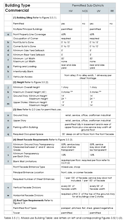
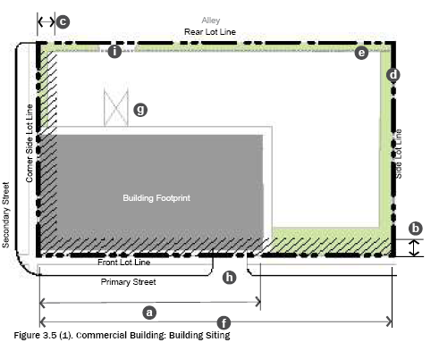
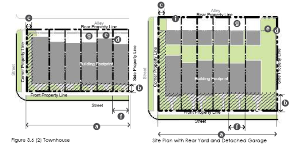
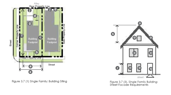
1. Building Siting
The following explains the line item requirements within the first section of each building type table entitled “Building Siting.” Setbacks are measured from the street ROW line or from the edge of the scenic buffer.
(1) Multiple Principal Structures. The allowance of more than one principal structure on a lot.
(2) Front Property Line Coverage/Measuring Front Property Line Coverage. Measurement defining the minimum percentage of street wall or building facade required along the street. The width of the principal structure(s) (as measured within the front build-to zone) shall be divided by the maximum width of the front build-to zone.
(a) Certain buildings have this number set to also allow the development of a courtyard along the front property line.
(3) Occupation of Corner. Occupying the intersection of the front and corner build-to zones with a principal structure.
(4) Front Build-To Zone. The build-to zone or setback parallel to the front property line. Building components, such as awnings or signage, are permitted to extend beyond the build-to zone.
(a) All build-To zone and setback areas not covered by building must contain either landscape, patio space, or sidewalk space.
(5) Corner Build-To Zone. The build-to zone or setback parallel to the corner property line.
(a) All build-to zone and setback areas not covered by building must contain either landscape, patio space, or sidewalk space.
(b) Corner build to zones do not apply to corner lots adjacent to the Highway 40/Scenic buffer.
(6) Additional Semi-Pervious Coverage. The additional percentage of a lot beyond the maximum impervious coverage, which may be surfaced in a semi-pervious material, including a green roof or pavers.
(7) Parking, Loading Location, and Parking Structure. The yard or structure in which a parking lot, detached garage, attached garage door access, loading and unloading, and associated drive is permitted.
(8) Vehicular Access. The permitted means of vehicular ingress and egress to the lot.
(a) Alleys, when present, shall always be the primary means of vehicular access.
(b) When alleys are not present, a driveway may be permitted per building type and, if an alternative is available, shall not be located off a major or minor collector.
(c) Driveways widths in residential zones shall not exceed 24 feet. Driveways in the villages, and for multi-family developments, shall be appropriately sized to allow for stacked right turns (flared).
(9) Required transitions and buffering for existing residential development, A 30’ landscaped buffer, that includes an undulating 4’ berm planted with evergreen trees and shrubs, is required between existing residential use and the nearest new building, measured from the property line. In addition, no new building may exceed 2 stories (28’) at that setback, but may increase in height by one foot with a corresponding one foot increase in setback, until the buildng type maximums are met.
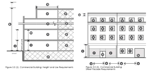
2. Height The following explains the line item requirements for each building type.
(1) Minimum Overall Height. The minimum overall height for the building shall be located within the build-to zone; stories above the required minimum height may be stepped back from the facade.
(2) Maximum Overall Height. The sum of a building’s total number of stories.
(a) Habitable stories located either completely within a pitched roof structure with dormers or in a visible basement exposed a maximum of one-half story above grade, shall be counted as half stories.
(b) To enhance skyline appearance, mixed use building heights in the UV sub-district may increase to five stories within an 800’ radius of UVU campus, as long as an average of four stories is achieved through lowered building heights, see D below.
(c) Some building types require a building facade to step back as its height increases. If required, the upper stories of any building facade with street frontage shall be setback a designated amount beyond the building facade of the lower stories.
(d) Height variations - maximum heights for mixed use, stacked residential, and commercial buildings shall vary with no more than 3 adjacent buildings at the same or very similar height. To meet this requirement, height variation by at least 10’ is required.
(3) Ground Story and Upper Story, Minimum and Maximum Height (Measuring Height). Each frontage type includes a permitted range of height in feet for each story. Additional information is as follows:
(a) Floor height is measured in feet between the floor of a story to the floor of the story above it.
(b) Floor height requirements apply only to street facing facades.
(c) For single story buildings and the uppermost story of a multiple story building, floor to floor height shall be measured from the floor of the story to the tallest point of the ceiling.
4. Public Utility Easements shall be located along street frontages unless rear lot lines are considered and approved by Engineering.
5. All utilities shall be placed underground.
Additional ordinance definitions can be accessed in Chapter 18.08
3. Uses
The following explains the line item requirements for each building. Refer to Section 2.0 for uses. The requirements in this section of the Building Type Tables may limit uses within a specific building type.
(1) Ground and Upper Story. The uses or category of uses which may occupy the ground and/or upper story of a building.
(2) Parking Within Building. The area(s) of a building in which parking is permitted within the structure.
(3) Required Occupied Space. The area(s) of a building that shall be designed as occupied space, defined as interior building space regularly occupied by the building users. It does not include storage areas, utility space, or parking.
4. Street Facade Requirements Street facade requirements apply only to facades facing a public or private right-of-way, including a parking lot. 360 degree architecture is required with no blank walls. The rear or interior side yard facades are not required to meet these standards unless otherwise stated. Large format store fronts are to be designed and built to represent a main street-like appearance with smaller storefronts.
(1) Minimum Ground Story and Upper Floor Transparency/Measuring Transparency per Facade. The minimum amount of transparency required on street facades with street frontage.
(a) Transparency is any glass in windows and/or doors, including any mullions, that is highly transparent with low reflectance.
(i) Ground story transparency, when defined separately from the overall minimum transparency, shall be measured between 2 feet and 8 feet from the average grade at the base of the front facade.
(ii) A general minimum transparency requirement shall be measured from floor to floor of each story.
(2) Blank Wall Limitations. A restriction of the amount of windowless area permitted on a facade with street frontage. If required, the following shall both be met for each story:
(a) No rectangular area greater than 30% of a story’s facade, as measured from floor to floor, may be windowless.
(b) No horizontal segment of a story’s facade greater than 15 feet in width may be windowless.
(3) Entrance Type. The entrance type(s) permitted for the entrance(s) of a given building type.
(4) Principal Entrance Location. The facade on which the primary building entrance is to be located. No front facades are anticipated along US 40. Front facades may access parking lots where sidewalk dining opportunities and or plazas are designed next to the buildings.
(5) Required Number of Street Entrances. The minimum number of and maximum spacing between entrances on the ground floor building facade with street frontage.
(6) Vertical Facade Divisions. The use of a vertically oriented expression line or form to divide the facade into increments no greater than the dimension shown, as measured along the base of the facade. Elements may include a column, pilaster, or other continuous vertical ornamentation that is a minimum of one and a half inch depth.
(7) Horizontal Facade Divisions. The use of a horizontally oriented expression line or form to divide portions of the facade into horizontal divisions. Elements may include a cornice, belt course, molding, string courses, or other continuous horizontal ornamentation a minimum of one and a half inch depth.
5. Unique Architecture
All development within NVOZ is intended to have a unique sense of place and custom architecture. Multiple requirements are found throughout this ordinance which require custom design for each building. No single family buildings on the same block face (on both sides of the street) may have the same street facing facade within a 400-foot distance. Building facade design must distinctly vary three of the following ve elements:
• Color • Roof Line • Materials • Window Locations and Door Locations • Exterior Wall Changes (to Create Shadow Patterns).
6. Roof Type The following explains the roof requirements for each building:
(1) Permitted Roof Type. The roof type(s) permitted for a given building type. Refer to 3.14. Roof Types for more specific requirements.
(2) Tower. A vertical building extension that may be permitted in
conjunction with another roof type on certain building types. Refer
to 3.14. Roof Types.
18.21.030.3.3 Mixed-Use Building
3.3 Mixed-Use Building
1. Description and Intent
The mixed-use building is intended to be located close to the front property line with parking located in the rear, side of the lot, and/or parking garages.
The key facade elements are large amounts of glass and regularly spaced entrances on the main floor.
This building is available for different levels of urban intensities,
depending on the district within which it is located.
2. Regulations
Regulations for the mixed-use building type are defined in the
adjacent table. All mixed-use buildings in the NV and UV subdistricts
shall incorporate mountain modern style features, as per Section 3.0.
Footnotes: 1 Lots wider than 140 feet are permitted one double-loaded aisle of parking (maximum width of 72 feet), located perpendicular to the front property line, which is exempt from front property line coverage.
2 Buildings taller than three stories shall have a step back of a minimum 10 feet, which is located in between top of first story to the top of the third story. The step back is required on street frontage sides only. As a substitute for a stepback, a combination of 1’ to 2’ facade depth variations, balconies, overhangs, and decks are permitted. Height variation required, as per 3.2 (2) d and may average up to five stories witin 800’ of UVU.
3 Ground floor up to 20’ shall count as one story.
4 In the case of plazas or porte cochere this may change up to a maximum of 25 feet as approved by Zoning Administrator.
5 Exposed parking garages shall use consistent materials and include exterior landscaping.
6 Buildings facing mountain connector street are permitted.
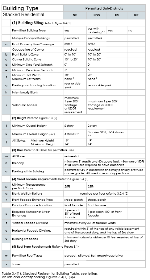
18.21.030.3.4 Stacked Residential Building
3.4 Stacked Residential Building
1. Description and Intent
The stacked residential building type is limited in terms of uses by the district
within which it is located, generally housing and/or residential uses.
The stacked residential building is intended to be built close to the front
and corner property lines, allowing easy access to passing pedestrians
and transit riders. Parking may be provided in the rear of the lot,
internally in the building, or, in some cases, one double-loaded aisle of
parking is permitted in the interior or the side yard at the front property line.
Footnotes: 1 A courtyard covering up to 35% of the front facade is permitted and may contribute to the front lot line coverage requirement.
2 Lots wider than 140 feet permit one double-loaded aisle of parking (maximum width of 72 feet) located perpendicular to the front property line, which is exempt from front property line coverage.
3 Buildings taller than three stories shall have a step back of a minimum 10 feet, which is located in between top of first story to the top of the third story. The step back is required on street frontage sides only. As a substitute for a stepback, a combination of 1’ to 2’ facade depth variations, balconies, overhangs, and decks are permitted. Height variation required, as per 3.2 (2) d
4 Ground floor up to 20’ shall count as one story.
5 Buildings facing Village & Neighborhood Connector streets are permitted.
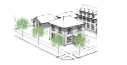
18.21.030.3.5 Commercial Building
3.5 Commercial Building.
1. Description and Intent.
The Commercial Building Type permits a lower level of ground floor Mixed-Use facade. A wider range of uses can also be accommodated within this Building Type. This Building Type is still intended to be built close to the front and corner property lines allowing easy access to passing pedestrians and transit riders. Commercial buildings shall have a maximum square foot building footprint of 100,000 SF.
2. Regulations.
Regulations for the Commercial Building Type are defined in the adjacent table.
 Footnotes:
1 Lots wider than 140 feet permit one double-loaded aisle of parking (maximum
width of 72 feet), located perpendicular to the front property line, which is exempt from
front property line coverage.
2 Facade depth variations of 1’ to 2’ are required based on the vertical facade divisions.
3 Four stories allowed for hospitality uses; heights may be modified by an MDA or AA.
4 New buildings with yards adjacent to existing single family or townhome
residential that are not within the NVOZ area shall have a maximum height of 36
feet within 30 feet of the property line and a landscape setback of 20 feet.
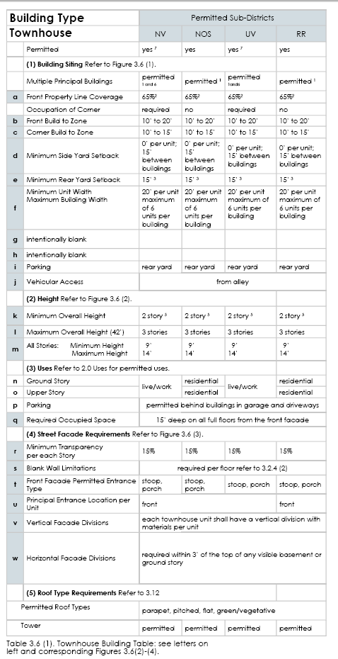
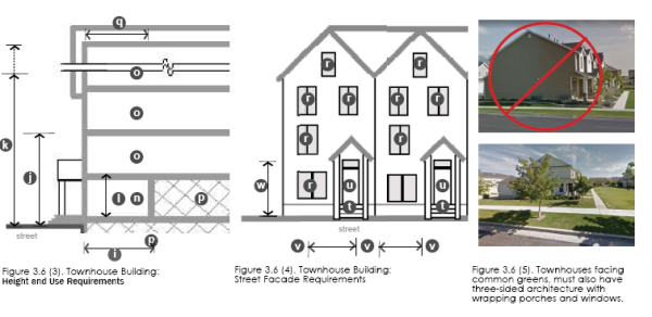
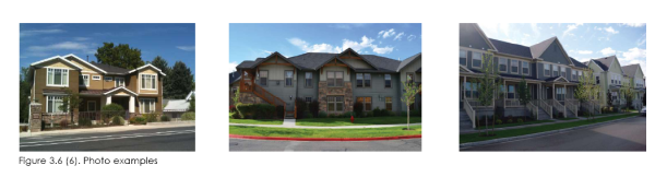
18.21.030.3.6 Townhouse Building
3.6 Townhouse Building
1. Description and Intent
The Townhouse Building is a building typically comprised of multiple vertical units, each with its own entrance to the street. This Townhouse Type may be organized as townhouses, duplexes, or row houses, or it could also incorporate live/work units where uses are permitted.
Parking is required to be located in the rear yard (alley loaded) and may be incorporated
either into a detached garage or in an attached garaged accessed from the rear
of the building. However, when the garage is located within the building, a minimum level
of occupied space is required on the front facade to ensure that the street facade is active.
 2. Regulations
Footnotes 1 For the purposes of the townhouse building, a building consists of a series of units. When permitted, multiple buildings may be located on a lot with the minimum required space between them. However, each building shall meet all requirements of the building type and shall conform to a building style as per section 3.0. A maximum of six units per building.
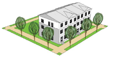
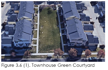
2 Each building shall meet the front property line coverage requirement, except three buildings of fi ve units each may front a courtyard with a minimum width of 50 feet (building to building, including sidewalks on all three sides). The green courtyard shall be defi ned on two-three sides by buildings. See figure 3.6(1).
3 Rear yard setback on alleys is 5 feet.
4 When the Mixed-use entrance type is utilized, the maximum ground story transparency for the unit is 55% as measured between 2 feet and 8 feet above grade.
6 In conjunction with a planned community, single story townhouses may be constructed for up to 25% of the community.
7 In the NV and UV zone Townhouses shall be located behind commercial buildings and not occupy the
commercial street frontage.
18.21.030.3.7 Single Family Building
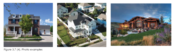
3.7 Single Family Building
1. Description and Intent
The single family building is a residential building incorporating a landscaped yard surrounding all sides of the building. The single family building typically includes one unit per building, but may include one ADU.
2. Regulations
Regulations for the single family building type are defined in the adjacent table. No more than 2 adjacent single family dwellings shall be built at the same setback and lot width. Setback variance is a minimum of 3’ and lot width variance is a minimum of 5 feet. In addition, driveway maximum width is 20’ for 35’ to 40’ wide lots, 24’ for lots up to 100 and 36’ for over 100’ wide lots.
Footnotes: 1 Each building shall meet all requirements of the single family building type.
2 When multiple buildings are located on a single lot, each building shall meet the front property line coverage requirement.
3 Rear yard setback for detached garages on alleys is 5 feet.
4 Street facing garage width is measured as the maximum percentage of total lot width
5 Garages shall be a minimum setback
from front of building (not including
porch or stoop).
18.21.030.3.8 Architectural Styles
3.8 Architectural Styles
1. Description and Intent
The North Village Overlay Zone is intended to have a distinct architectural style and character. Builders and designers are to select from the permitted building types and building styles and follow the guidelines.
Images of buildings included in the document are representative interpretations of the an architectural style, not exact templates for future construction. There are many possible successful interpretations of the proposed architectural styles. It is not expected nor desired that each building incorporate all characteristic elements of the style, or all of the predominant materials on a single structure. These guidelines and requirements establish a baseline performance threshold with specific evaluation criteria to be used by City staff to determine compliance. Applicants must demonstrate compliance with these standards through building elevations that include material selections. Architectural renderings for all proposed buildings, are required at final and/or site plan approval as well as to obtain a building permit.
2. Neighborhood and Village Identity
A neighborhood or village is physically uni ed by common design features, including a variety of building shapes, distinct style, roof types, facade treatments, unifying elements, consistent quality of materials, and consistent execution of details with a pleasing array of colors, coupled with addressing and engaging public spaces and streets. The buildings in the NVOZ, as a combined group, shall contribute to the overall architectural theme and establish a sense of place.
3. Four-Sided Architecture
The design of all four sides of each building are regulated by design requirements in this code. All four sides of a building area are considered important shall not contain any blank walls. Building facades facing a street, including US 40, shall include the front facade variation required for each building type.
4. Architectural Design Theme
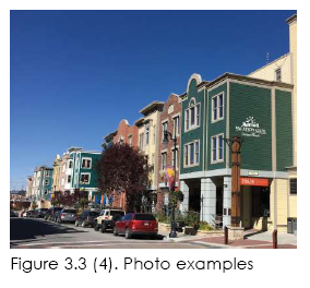
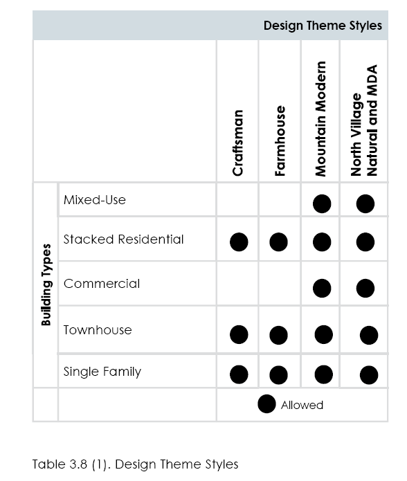
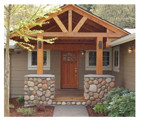
The architectural theme for the North Village Overlay Zone is inspired by the historic agricultural tradition in Heber Valley and the mountain valley geography. Acceptable styles include craftsman, farmhouse, mountain modern, and natural style (which may be further designed through a MDA).
5. Lighting
All outdoor lighting shall be dark skies compliant, which is shielded
and downward-directed lighting.
 7. Design Principles
Avoid using exposed timber as a decoration.
7. Design Principles
Avoid using exposed timber as a decoration.
Avoid using load bearing material (brick and stone) in a manner that defies gravity. Brick and stone should never appear to float in the air.
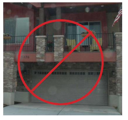
Architecture design should not make the garage the most prominent feature of the home. Garage forward architecture is not allowed.
Over-application of gables as an ornamental feature. Consider the roof from the initial stages of designing the floor plan.
Load bearing material (brick and stone) should touch the ground. Timber elements should feel like a natural extension of interior volumes, or the repetition of primary structural elements inside the home or building. Timber should make structural sense in terms of scale and be proportionate to the structural integrity of the home. Columns should include a plinth/ base and should be proportional to the structures they support.
Use load bearing material in a manner that makes structural sense. Heavy materials support lighter materials.
Simplified roof lines are easier to build and look better than roofs with endless gables and steps. Gables should be used as a snow shedding and drainage management strategy. Apply gables to protect entrances and prevent snow from shedding on the walks and entrances as well as to break up large roof areas on big buildings.
Use vertically proportioned windows to help break up facades and blank walls and allow additional light into the interior living space. If a horizontal expansion of glass is desired, this should be accomplished by incorporating multiple vertical windows side by side.
Single-height entrances correspond to the human scale and
provide adequate protection from the elements.
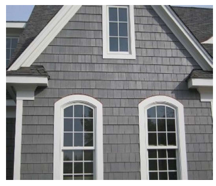
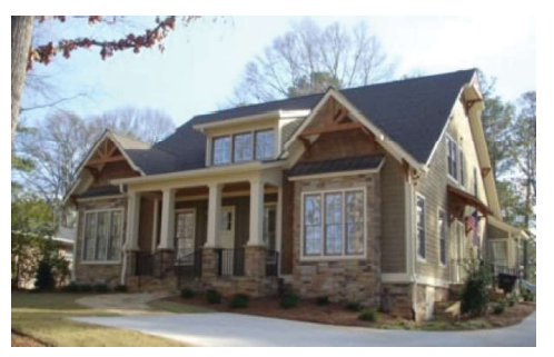
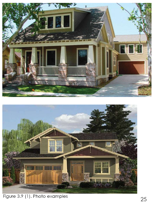
18.21.030.3.9 Craftsman
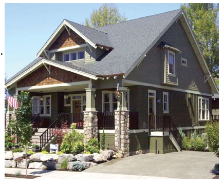
3.9 Craftsman
(1) The Craftsman style is characterized by simplicity, the expression of certain structural members, and attention to wood joinery, especially at porches. Craftsman homes feature moderate-pitched gable roofs with wide overhangs and large porches with substantial columns and bases.
(2) The principal features of the Craftsman style are low- to moderate-pitched gable roofs with wide overhangs, exposed rafters at porches, and, wherever feasible, generous porches with substantial columns and bases. Dormers are typical on 1½-story designs. Symmetry is optional and depends on the orientation of the principal roof.
(3) Ornamentation is restrained. Details that are characteristic of the style include exposed rafter tails, tapered columns and trim elements, and diagonal knee braces at gable ends. Wall materials may include stone, brick, limited stucco (not to exceed 20% of facade), shingles, and siding (no vinyl).
(4) Massing
•A side gable, center gable facing the street, or cross gable with dormers is typical for the primary roof form. • One-story and 1½-story massing compositions are permitted, although two-story compositions can also be acceptable. • Dormers are typical in 1½-story designs. • Emphasis should be on horizontal rather than vertical lines.
(5) Roofs
• Low-sloping gable roofs with wide overhangs are typical. • Shed or pitched dormers are common. • Generously sized eaves with exposed decorative rafters are characteristic of the style, but not required. • Main roof pitches: 6:12 to 8:12. Secondary hip or shed roof pitches: 3:12 to 6:12. • Roof overhangs: 12-30 inches at rakes and eaves
(6) Windows and Doors
• Individual windows are typically square or vertically oriented. • Windows are often mulled together in pairs or threes. • Double-hung windows with divided panes in upper sashes only, usually in a three-over-one con guration, are typical. • Limited use of small accent windows and angled bays is encouraged. A single, rectilinear door is typical. • Large panes in doors are common and are often divided to match the windows. • Wide trim (5 to 6 inches) with head trim extending past the jamb is typical for doors and windows. • Tapered side trims are typical.
(7) Porch/Entry
• Porches facing the street are common. • Porch columns typically sit on wider bases or low walls. • Tapered or double-columns with header and base details are common.
(8) Details
• Expression of structural members and attention to wood joinery is characteristic of the style. • Beams, knee braces, and brackets are often found at gable ends. • Extended lintels over door and porch openings are common. • Tapered elements, including trim work and columns, are common.
(9) Minimum Required Elements
□ Front porch that addresses the street, either full or partialwidth
(60 square-foot minimum)
□ Square columns (tapered or straight), stone or brick plinths,
structural or decorative beams or braces under gables,
□ Decorative trim (5 to 6-inch width) around windows with
emphasis on top and bottom (no stucco)
□ Stone or brick on all street facing facades (20% minimum),
lap siding or batt and board siding (no vinyl) on all four sides of
the structure
□ Main roof pitches 6:12 to 8:12, wide eave overhangs (12-inch
minimum)
□ Recessed (2-foot minimum from front facade), decorative
garage door with small pane windows
□ Brick or stone to follow nished grade within 12 inches
□ Complimentary veneered or textured/colored foundations,
where exposed to view
18.21.030.3.10 Farmhouse
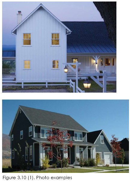
3.10 Farmhouse
(1) The Farmhouse style is characterized by a gable roof facing the street. The main gable may be combined with wings on one or two sides or emerge from a larger hip-roofed rectangular volume. A one-story porch should be provided and integrated into the front facade. Gable, hip, shed, or special dormers are employed to provide additional oor area, daylight, and architectural interest. Facade compositions should feature symmetrically placed, vertically proportioned, double or single-hung windows. Symmetry in the overall composition is optional.
Detailing should be simpli ed. Ornamentation should be minimized at porches, gable ends, and special features, such as bays. Appropriate wall materials may include horizontal lap siding and board and batten siding.
(2) Massing
• A front-facing gable without side wings is typical. • Overall massing should be simple and emphasize vertical building elements. • Projecting bays and low-sloping shed roofs are common. • 1½ to two-stories are typical, with a main level oor-to-ceiling height of 8 to 10 feet.
(3) Roofs
• Gable roofs facing the street are typical. Use of shed or gable-end dormers is encouraged. • The main gable is often intersected by other roofs. • Metal accent sections. • Main roof pitches: 6:12 to 12:12 • Secondary hip or shed roof pitches: 3:12 to 6:12 • Roof overhangs: 6 to12 inches
(4) Windows and Doors
• Vertically proportioned double and single-hung windows are typical. • Individual or paired window treatments are common. • Square and angled bay window treatments are common. • Wide (4 to 6-inch) exterior trim and cap moldings on windows and doors are typical. • Limited use of multi-pane sashes with divided panes is encouraged and may occur in both sashes in the following con gurations: oneover- one, two-over-one, two-over-two, four-square-grid-over-one, and four- square-grid-over-four-square-grid. • Panes in doors are common and often express ornamentation.
(5) Porch/Entry
• Street-facing, one-story porches are common. Wraparound porches are encouraged at corner lots. • Porch roofs are typically forward-facing shed or hip. • Porches may have exposed wood and metal elements. • Square columns (at least 6x6 inch) or round columns (at least 6 inches) are typical. • Railings may be turned, square balusters or steel.
(6) Details
• Detailing is simpli ed and ornamentation is restrained. • Exposed structural elements on porches are typical. Any exposed concrete foundation must be clad with stone or brick. • Ogee or half-round gutters are common. • Board and batten wainscoting (in courser spacing) is recommended. • Square or more detailed moldings along rakes are common.
(7) Minimum Required Elements
□ Covered porch with support columns that have a base, shaft,
and capitol
□ Vertically-oriented windows
□ Decorative trim (5 to 6-inch width) around windows with
emphasis on top and bottom (no stucco)
□ Recessed (2-foot minimum from the front facade), decorative
garage door with small pane windows
□ Full or partial width (over 50% of the front facade) covered
front porch that addresses the street (Porch calculations for
single family homes may include a wrapped porch around the
corner of the house.)
□ Lap siding or batt and board siding (no vinyl) on all four sides
of the structure
□ Multifamily structures shall incorporate stone or brick on the
ground floor (10% minimum on each elevation), include a
private outdoor space or balcony of 60-square-foot minimum,
and a covered front porch to address the street or common
area
□ Complimentary veneered or textured/colored foundations,
where exposed to view
□ Shielded and downward directed lighting
18.21.030.3.11 Mountain Modern
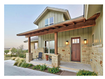
3.11 Mountain Modern
(1) The Mountain Modern style is characterized by a pitched or flat roof that is capable of withstanding heavy snow loads. The main roof pitch often extends over deck and patio areas to provide additional weather protection over adjacent decks or patios. Roof planes over the entry patio or courtyard are typical of the front facade. Facade compositions should feature dominant, expanses of glazing with wide roof overhangs providing protection from solar exposure.
Detailing should be simplified. Simple ornamentation should be incorporated at porches, entries and decks. Appropriate wall materials may include stone or natural wood siding.
(2) Massing
• Simple geometric forms. • Overall massing should be simple and emphasize horizontal building elements. • Pitched roofs are common. • One and two stories are typical, with a main level oor-to-ceiling height of 10 to 14 feet.
(3) Roofs
• Single-pitched roofs dominate. • The main roof is often penetrated by stone chimneys, often represented as oversized massing elements. • Roof overhangs extending the roof coverage to patios and decks are typical.
(4) Windows and Doors
• Large expanses of floor to ceiling glass are typical. • Sliding doors that extend the interior space outward onto decks and patios are typical. • Untrimmed windows and doors that incorporate the glazed element into the exterior wall plane as an extension of the dominant plane are typical.
(5) Porch/Entry
• Street-facing, or side turned one and two-story entry decks are common. Walled entry courtyards are common. • Entries often utilize detailed expressions of exposed wood, stone and metal siding elements. • Entries should have pitched or sloped roofs that can be a separate roof line from the main ridges.
(6) Details
• Detailing is simpli ed and ornamentation is restrained. • Exposed structural elements are typical. • Hidden gutters that are integrated into the roof structure are common. Downspouts are often included as “rain-chains” that funnel the runoff into a ground level pond or stream element. • Detailing is often based on rustic or craftsman elements typical to the local area.
(7) Minimum Required Elements
□ Front porch that addresses the street, either full or partial width
(60-square-foot minimum) that incorporates timber
columns with stone plinths/bases and timber trusses that reflect
the internal structure of the building
□ Timber beams or braces under gables
□ Stone on front facade (20% minimum)
□ Lap siding or batt and board siding (no vinyl) on all four
sides of the structure
□ Wide eave overhangs (18 inch minimum)
□ Recessed (2-foot minimum from the front facade)
decorative garage door with small pane windows
□ Full metal or metal accent pitched roofs, especially on
porch areas
□ Complimentary veneered, or textured/colored foundations,
where exposed to view
□ Decorative wood or wood-like appearance garage doors
recessed from the front plane of the building
□ Multifamily structures shall incorporate stone or brick on the
ground floor (20% minimum on each street facing elevation),
include a private outdoor space or balcony of 60-square-foot
minimum, and a covered front porch to address the street or
common area
□ Commercial and mixed use buildings shall incorporate stone
or brick on the ground floor (20% minimum on each elevation),
balconies of 60-square-foot minimum for residential uses, and
metal roofed shed roof/awnings (minimum 6-foot depth)
to protect pedestrians from inclement weather in building
entrance areas.
18.21.030.3.12 North Village Natural/MDA Defined
3.12 North Village Natural/ MDA Defined
(1) The North Village Natural style is characterized by one-direction sloped “shed” style roof construction. Variation in roof lines is required. Snow loads are designed to slide off, but should not slide onto entrances and outdoor porch/patio spaces. Roofs may be free form and include curves/arcs. The main roof section may extend over deck and patio areas to provide additional weather protection and to create a distinctive outline. Facade composition should feature larger windows with substantial roof overhangs.
Detailing should be simplified. Simple ornamentation should be incorporated at porches, entries, and decks. Appropriate wall materials may include stone or natural/transparent stained wood siding. Colors and materials are intended to blend with the natural setting.
North Village Natural style may be utilized in all sub-districts as the principle architectural style and may be further defined through an MDA.
(2) Massing
• Simple geometric forms. • Overall massing should be simple and emphasize horizontal building elements. • Varied pitched and shed-style roofs are common. • Two stories are typical, with a main level floor-to-ceiling height of 10 to14 feet.
(3) Roofs
• Variable roofs. • The main roof is often penetrated by stone chimneys. • Roof overhangs extending roof coverage to patios and decks are typical. • Vegetated/green roof.
(4) Windows and Doors
• Large expanses of glass are typical. • Sliding doors that extend the interior space outward onto decks and patios are typical.
(5) Porch/Entry
• Street-facing are common. Semi-enclosed and accented entry courtyards are common. • Entries often utilize detailed expressions of exposed wood, stone, and metal siding. • Entries are protected from sliding roof snow loads and from inclement weather.
(6) Detail Elements
• Detailing is simplified and ornamentation is restrained. • Exposed structural elements are typical. • Gutters are not required, but controlled roof runoff into the landscaping is required. • Drainage from driveways is funneled into the yard landscaping. • Detailing is often based on rustic elements typical to the local area.
(7) Minimum Required Elements
□ For residential use, front door/porch addresses the street and
incorporates timber columns with stone plinths/bases and timber
trusses that present a focused entry to the building
□ Exposed timber beams or braces under gables
□ Stone (including cultured stone) on front and visible sides of
the building (20% minimum), with stonework continuing to the
ground where there are exposed foundations
□ Complimentary veneered or textured/colored foundations,
where exposed to view, in addition to any stonework as
required above
□ Lap siding or batt and board siding (no vinyl) on all four sides
of the structure
□ Wide eave overhangs (18-inch minimum)
□ Metal and wood simulating architectural shingles accenting
varied pitched roofs
□ Recessed decorative wood or wood-like garage doors with
small pane windows and wood accents. Such doors shall be
recessed (2-foot minimum from the front façade) from the front
plane of the building, and preferably turned away from the
street
□ Multifamily structures shall incorporate stone or brick on the
ground floor (20% minimum on each street facing elevation),
include a private outdoor space or balcony of 60-square-foot
minimum for each unit, and a covered front porch for each unit
to address the street or common area
□ Commercial and mixed use buildings shall incorporate stone
or brick on the ground floor (20% minimum on each street
facing elevation), balconies of 60-square-foot minimum for
residential uses, and metal roofed shed roof/awnings(minimum
6-foot depth) to protect pedestrians from inclement weather in
building entrance areas
18.21.030.3.13 Entrance Types
5.13 Entrance Types
Entrance type standards apply to the ground story and visible basement of front facades of all building types as defined in this section. Refer to the Building Type Table Requirements, Sections 3.3 through 3.7.
1. General
The following provisions apply to all entrance types.
(1) Intent. To guide the design of the ground story of all buildings to relate appropriately to pedestrians on the street. Treatment of other portions of the building facades is detailed in each building type standard (refer to Building Types 3.3 through 3.7).
(2) Applicability. The entire ground story street-facing or shared parking area facade(s) of all buildings shall meet the requirements of at least one of the permitted entrance types, unless otherwise stated.
(3) Measuring Transparency. Refer to 5.2 Explanation of Building Type Table Standards, for information on measuring building transparency.
2. Mixed-Use Entrance Type
(Refer to Figure 3.13 (1).) The mixed-use entrance type is a highly transparent ground story treatment designed to serve primarily as the display area and primary entrance for retail or service uses.
(1) Transparency. Minimum transparency is required per building type.
(2) Elevation. Mixed-use elevation shall be between zero and 1 foot above sidewalk.
(3) Visible Basement. A visible basement is not permitted.
(4) Horizontal Facade Division. Horizontally define the ground story facade from the upper stories.
(5) Entrance. All entries shall be recessed from the front facade closest to the street.
(a) Recess shall be a minimum of 3 feet and a maximum of 8 feet deep, measured from the portion of the front facade closest to the street.
(b) When the recess falls behind the front build-to zone, the recess shall be no wider than 8 feet.
3. Arcade Entrance Type
(Refer to Figure 3.13 (2).) An Arcade entrance type is a covered pedestrian walkway within the recess of a ground story.
(1) Arcade. An open-air public walkway is required from the face of the building recessed into the building a minimum of 8 feet and a maximum of 15 feet.
(2) Build-to Zone. When the arcade is utilized, the outside face of the arcade shall be considered the front facade, located within the required build-to zone.
(3) Recessed or Interior Facade. Mixed-use entrance type is required on the recessed ground story facade.
(4) Column Spacing. Columns shall be spaced between 10 feet and 12 feet on center.
(5) Column Width. Columns shall be a minimum of 1 foot, 8 inches and a maximum 2 feet, 6 inches in width.
(6) Arcade Opening. Opening shall not be flush with interior
arcade ceiling and shall be arched.
4. Stoop Entrance Type
(Refer to Figure 3.13 (3).) A stoop is an unroofed, open platform.
(1) Transparency. Minimum transparency is required per building type.
(2) Stoop Size. Stoops shall be a minimum of 3 feet deep and 6 feet wide.
(3) Elevation. Stoop elevation shall be located a maximum of 2 feet, 6 inches above the sidewalk without visible basement and a maximum of 4 feet, 6 inches above the sidewalk with a visible basement.
(4) Visible Basement. A visible basement is permitted and shall be separated from the ground story by an expression line.
(5) Entrance. All entries shall be located off a stoop.
5. Porch Entrance Type
(Refer to Figure 3.13 (4).) A porch is a raised, roofed platform that may or may not be enclosed on all sides. Awnings may be substituted for roof structures.
(1) Transparency.
(a) Minimum transparency per building type is required.
(b) If enclosed, a minimum of 40% of the enclosed porch shall be comprised of highly transparent, low reflectance windows.
(2) Porch Size. The porch shall be a minimum of 5 feet deep and 8 feet wide.
(3) Elevation. Porch elevation shall be located a maximum of 2 feet, 6 inches above the sidewalk without a visible basement and a maximum of 4 feet, 6 inches above the sidewalk with a visible basement.
(4) Entrance. All entries shall be located off a porch.
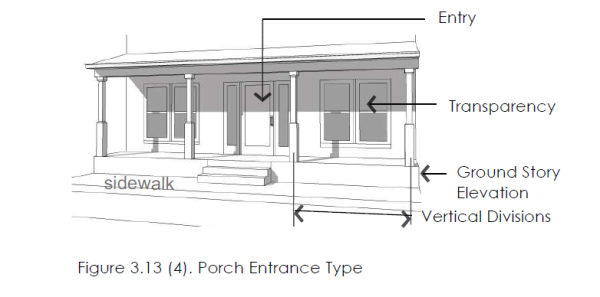
18.21.030.3.14 Roof Types
3.14 Roof Types
Roof type standards apply to the roof and cap of all building types as defined in this section. Refer to Building Type Table Requirements, Sections 3.3 through 3.7.
1. General Provisions
The following provisions apply to all roof types.
(1) Intent. To guide the design of the cap of all buildings.
(2) Applicability. All buildings shall meet the requirements of one of the roof types permitted for the building type.
(3) Measuring Height. Refer to Section 3.2.2 for information on measuring building height.
(4) Other Roof Types. Other building caps not listed as a specific type may be made by a request to the zoning administrator with the following requirements:
(a) The roof type shall not create additional occupied space beyond that permitted by the building type.
(b) The shape of the roof type shall be significantly different from those defined in this section, 3.14 Roof Types, (i.e. a dome, spire, vault).
(c) The building shall warrant a separate status within the community from the fabric of surrounding buildings, with a correspondence between the form of the roof type and the intent of the building use.
(d) Green/vegetative roofs are encouraged.
2. Parapet Roof Type
(Refer to Figure 3.14 (1), Parapet Roof Type.) A parapet is a low wall projecting above a building’s roof along the perimeter of the building. It can be utilized with a flat or low pitched roof and also serves to limit the view of roof-top mechanical systems from the street.
(1) Parapet Height. Height is measured from the top of the upper story to the top of the parapet.
(a) Minimum height is 2 feet with a maximum height of 6 feet.
(b) The parapet shall be high enough to screen the roof and any roof appurtenances from view of the street(s).
(2) Horizontal Expression Lines. An expression line shall define the parapet from the upper stories of the building and shall also define the top of the cap.
(3) Occupied Space. Occupied space shall not be incorporated behind this roof type, except for open air rooftop gathering spaces.
(4) Flat roofs may incorporate green roof landscaping.
3. Single Sloped Roof Type
(Refer to Figure 3.14 (2), Pitched Roof Type.) This roof type has a sloped or pitched roof. Slope is measured with the vertical rise divided by the horizontal span or run.
(1) Pitch Measure. The roof may not be sloped less than a 4:12 (rise:run) or more than 16:12.
(a) Slopes less than 4:12 are permitted to occur on second story or higher roofs. (Refer to Figure 5.12 (2) Low Pitched Roof).
(b) Low pitch green roofs may be allowed.
(2) Configurations.
(a) Hipped, gabled, single sloped and combination of hips and gables with or without dormers are permitted.
(b) Gambrel, butterfly and mansard roofs are not permitted.
(3) Parallel Ridge Line. A gabled end or perpendicular ridge line shall occur at least every 100 feet of roof when the ridge line runs parallel to the front lot line. (Refer to Figure 3.14 (2). Parallel Ridge Line.)
(4) Roof Height. Roofs without occupied space and/or dormers shall have a maximum height on street-facing facades equal to the maximum floor height permitted for the building type.
(5) Occupied Space. Occupied space may be incorporated
behind this roof type.
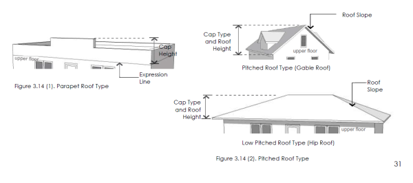 4. Flat Roof Type
(Refer to Figure 3.14 (3). Flat Roof Type.) This roof type has a flat roof with overhanging eaves.
(1) Configuration. Roofs with no visible slope are acceptable. Eaves are required on all street facing facades.
(2) Green/vegetative roofs are encouraged and permitted.
(3) Eave Depth. Eave depth is measured from the building facade to the outside edge of the eave. Eaves shall have a depth of at least 14 inches.
(4) Eave Thickness. Eave thickness is measured at the outside edge of the eave, from the bottom of the eave to the top of the eave. Eaves shall be a minimum of 8 inches thick.
(5) Interrupting Vertical Walls. Vertical walls may interrupt the eave and extend above the top of the eave with no discernible cap.
(a) No more than one-half of the front facade can consist of an interrupting vertical wall.
(b) Vertical walls shall extend no more than 4 feet above the top of the eave.
(3) Occupied Space. Occupied space shall not be incorporated behind this roof type.
5. Roof Projections and Towers
(Refer to Figure 3.14 (4). Tower.) A tower is a rectilinear or cylindrical vertical element that must be used with other roof types.
1. General Projections - projections to a greater height than the maximum allowed for the building shall be permitted for such features as stairway enclosures, parapets, chimneys, shade structures, solar cells, landscaping and similar features, as determined by the Zoning Administrator, but in no case shall such features allow for human habitation.
2. Towers
(1) Quantity. All building types/styles, are limited to one tower per building and only permitted in NV and UV sub-districts adjacent to the intersection of two streets.
(2) Tower Height. Maximum height, measured from the top of the parapet or eave to the top of the tower, is the equivalent of the height of one upper floor of the building to which the tower is applied.
(3) Tower Width. Maximum width along all facades is one-third the width of the front facade or 30 feet, whichever is less.
(4) Horizontal Expression Lines. An expression line shall define the tower from the upper stories, except on single family or attached house residential building types.
(5) Occupied Space. Towers may be occupied by the same uses allowed in upper stories of the building type to which it is applied.
(6) Application. May be combined with all other roof types.
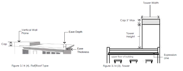
18.21.030.3.15 Additional Design Requirements
5.13 Additional Design Requirements
The following outlines the NVOZ design guidelines that affect a building’s appearance and sub-district cohesiveness. They improve the physical quality of buildings, enhance the pedestrian experience, and protect the character of the neighborhood.
1. Materials and Color
(1) Primary Facade Materials. 80% of each street facing facade shall be constructed of primary materials. For facades over 1,000 square feet, more than one material shall be used to meet the 80% requirement.
(a) Permitted primary building materials include high quality, durable, natural materials, such as stone; brick; wood lap siding; fiber cement board lapped, shingled, or panel siding; and glass. Other high quality synthetic materials may be approved during the site plan process by the zoning administrator with an approved sample and examples of successful, high quality local installations. Vinyl and aluminum slats are not permitted, except soffit, fascia and gutter applications. Refer to Figure 3.15 (1).
(2) Secondary Facade Materials. Secondary materials are limited to details and accents and include gypsum reinforced fiber concrete for trim and cornice elements; metal for beams, lintels, trim, and ornamentation; and exterior architectural metal panels and cladding.
(a) White colors allowed only when they blend with adjacent materials.
(3) Roof Materials/colors. Acceptable roof materials include non-reflective 300 pound or better, dimensional asphalt composite shingles; wood shingles and shakes; standing seam painted metal, slate, and vegetated/green roofs. “Engineered” wood or slate may be approved by with a sample approved by the zoning administrator. Refer to Figure 5.13 (2). Where visible, roof colors shall be earth toned with an emphasis on tan, brown, green/brown mixes. Flat roofs with parapets are permitted and encouraged to have vegetated/green roofs. Flat roofs are exempt from material requirements.
(4) Color. Main building colors shall utilize earth toned traditional
palettes from any major paint manufacturer. Other colors
may be utilized on details and accents, not to exceed a
total area larger than 10% of the facade surface area.
Colors not to be used include bright and neon colors.
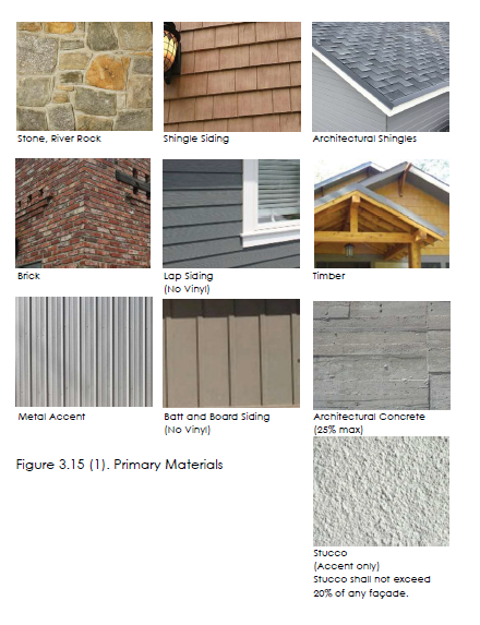
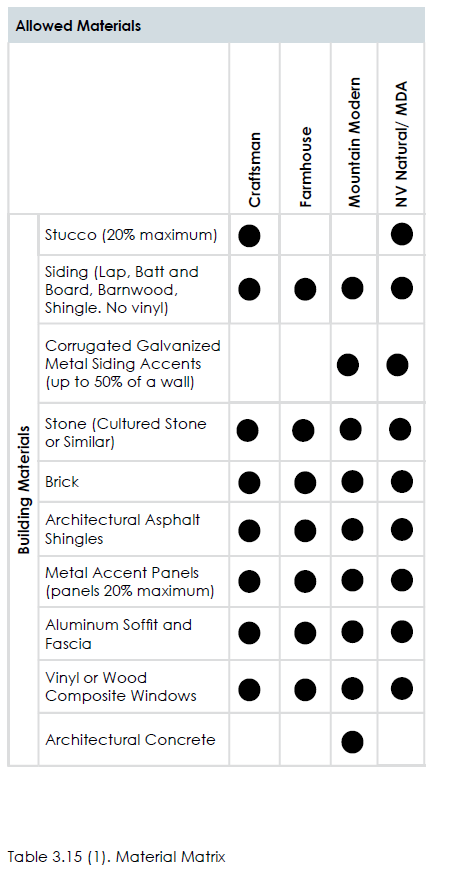 2. Windows, Awnings, Shutters and Doors
(1) Windows. All upper story windows on all residential and mixed use buildings shall be recessed, double hung. Percent of transparency is required per building type.
(2) Awnings. All awnings shall be canvas or metal. Plastic and vinyl awnings are not permitted. Awning types and colors for each building face shall be coordinated. Refer to Figure 5.13 (4).
(3) Shutters. If installed, shutters, whether functional or not, shall be sized for the windows. If closed, the shutters shall not be too small for complete coverage of the window. Shutters shall be wood. “Engineered” wood may be approved by the zoning administrator.
(4) Appropriate Grade of Materials. Commercial quality doors,
windows, and hardware shall be used on all building types
with the exception of the townhouse building and single
family buildings. Refer to Figure 3.15 (3).
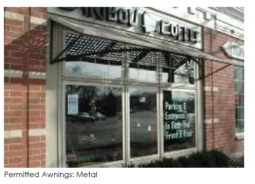
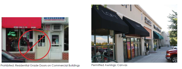
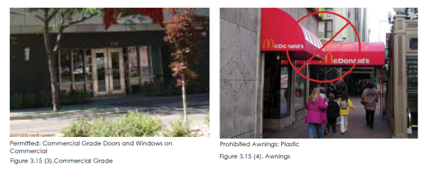
3. Balconies
The following applies in all locations where balconies are incorporated into the facade design facing any street or parking lot. Refer to Figure 3.15 (5).
(1) Size. Balconies shall have minimum dimensions of 6 feet deep and 8 feet wide, with a total square footage of not less than 60 square feet. Balconies are required for a minimum of 50% of the units in stacked residential and mixed-use buildings. Balconies may substitute for the required facade variation on rear and side facades.
(2) Connection to Building. Balconies that are not integral to the facade shall be independently secured and unconnected to other balconies.
4. Treatments at Terminal Vistas
When a street terminates at a parcel, the parcel shall be occupied by one of the following:
(1) If the parcel is open space, any open space type with the exception of the pocket park shall be utilized and a vertical element shall terminate the view. Acceptable vertical elements include a stand or grid of trees, a sculpture, or a fountain. (2) If the parcel is not utilized as an open space type, the front or corner side of a building, whether fronting a primary street or not, shall terminate the view. The building shall incorporate one of the following treatments to terminate the view: a mountain peak, a tower, a bay, or a courtyard. Refer to Figure 3.15 (6) for one illustration of this requirement.
5. Building Variety
Building design shall vary between vertical facade divisions, where required per the building types, and from adjacent buildings by the type of dominant material or color, scale, or orientation of that material and at least two of the following:
(1) The proportion of recesses and projections.
(2) The location of the entrance and window placement, unless mixed-uses are utilized.
(3) Roof type, plane, or material, unless otherwise stated in the
building type requirements.
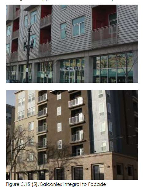
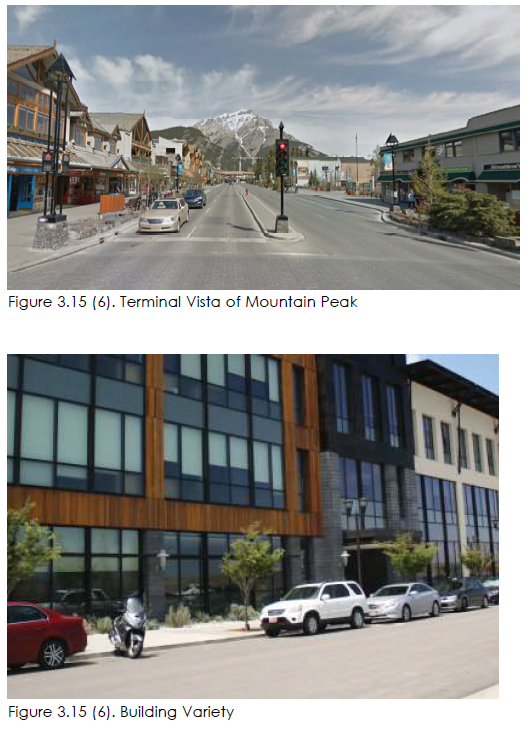
6. Drive-through Structures
Refer to Figure 3.15 (7) for one illustration of the following requirements.
(1) Structure/Canopy. Drive-through structures or canopies shall be located on the rear facade of the building or in the rear of the lot behind the building, where permitted by use.
(2) Stacking Lanes. Stacking lanes shall be located behind the building and accommodate at least two cars in a lane in addition to the car at the window and allow for additional stacking out of the primary driveway accesses
(3) The canopy and structure shall be constructed of the same
materials utilized on the building.
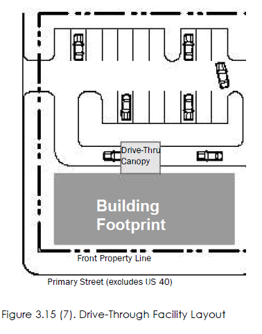
18.21.040.4.1 Streets
4.1 Streets 1. General Requirements
(1) Streets should be structured on a street network system where feasible, with limited cul-de-sacs, in order to allow for buildings to be oriented to the streets, have front door access, downplay garages, and provide for walkable neighborhoods. Street networks can be adapted to topography and terrain as needed. (2) General Requirements: Streets shall support the overall connectivity requirements for the NVOZ area. They should balance all forms of mobility while maximizing convenience for pedestrians and bicyclists. Transportation systems should be planned to accommodate future transit. All streets and street layouts are subject to review and approval by Heber City. (3) The character of streets within the North Village Overlay Zone will vary based on their location within specific sub-districts. Public rights-of-way (ROW) shall conform to the street cross sections appropriate to the area they are applied. (4) Primary and Secondary Street Network Criteria: The following priorities and outcomes shall guide the development of the primary and secondary street network and the implementation of this section and its technical guidance herein:
(a) Neighborhoods shall aim to be connected to one another through a woven collector system that offers several external access points. (b) There shall be a hierarchy of streets with more important streets at key locations. (c) A variety of on-street parking conditions (angled parking, parallel parking) shall be employed to calm traffic on retail and commercial streets in NV and UV sub-districts. (d) Walking and cycling should be a safe, efficient, and convenient option for movement within the network. (e) Access to local commercial and business destinations from adjacent neighborhoods should generally be achieved via trails and collector and local streets that are consistent with the contextual sub-district in which they reside. (f) Alternate routes should be available for traffic congestion relief at peak times. Avoid the need to access a state highway to travel north and south. Figure 4.1 (1). Residential Street Example Figure 4.1 (2). Commercial Street Example (page 37) (g) The street types established in and networks encouraged by this section should encourage efficient travel, but with slower speeds. (h) Roadways should reduce slope issues through a careful consideration of topography and avoid features such as gullies/drainages. (i) Links between streets, alleys, and trails should be purposeful and integrated into the transportation network.
(5) Address all features of the street right-of-way, including
sidewalks, parkways, traffic lanes, bicycle lanes, street lights,
street furniture, and swales.
(6) Create streets that are appropriate for their contexts in
residential, mixed-use commercial villages, and design to
encourage travel at appropriate volumes and speeds.
(7) Create streets and public rights-of-way that result in
stormwater runoff quantity reduction and improved water
quality through the use of low impact development (LID)
stormwater design.
(8) All construction in the right-of-way shall follow specifications
defined by the department of public works.
(9) Street types defined in this section outline acceptable street
configurations; refer to 4.4 through 4.9. (page 37) The graphics provided
here, illustrating each street type, are illustrative possible
configurations of that street type. New streets should be
designed using the principles and characteristics defined by
each street type. The zoning administrator in consultation with
city engineer may require additional right-of-way, pavement
width, or additional street elements depending on unique site characteristics.
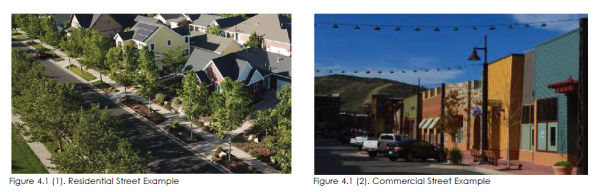
18.21.040.4.2 Street Network
4.2 Street Network
1. Purpose
(1) Overview: Connectivity is a vital part of community life. Streets connect us to our homes, families, friends, work, recreation, shopping, and our every day needs. Streets are the lifeblood of our communities. Commercial areas and downtowns benefit from smaller blocks as seen in the original Heber City grid (400’ x 400’) (Figure 4.2)(1)), but networks can also be adapted to more radial and organic designs to accommodate steep topography (Figure 4.2.(2)).
(2) While the concept of connectivity is simple, it is important to establish clear metrics and standards to define, measure, and improve connectivity. These standards center around two primary concepts: the maximum side of a single block and maximum perimeter of the entire block. Blocks are the defining components of grids, street networks, and street transportation systems.
(3) Blocks, together with streets, shall form the network of
thoroughfares and public spaces. Blocks shall generally be
small-to-moderate in size and rectangular in shape but may
be modified to accommodate site conditions.
2. Definitions
(1) Block. A contiguous group of properties bounded by multiple thoroughfares, rights-of-way, railroads, water bodies, or other similar features. The block’s perimeter is formed by outer property lines of the properties within the block (Figure 4.2(3)).
(2) Block Length. The length of one side of a block between two streets (Figure 4.2(3)). A block does not include the right-ofway.
(3) Block Perimeter Length. The aggregate of all the block lengths around the entire perimeter of the block.
(4) Cul-de-sac. A street ending in a vehicular turnaround whose roadway does not connect to other streets.
(5) Trail/Pathway. A trail/path reserved for pedestrian or other non-motorized use. May be privately owned but must be publicly accessible to meet pedestrian pathway connectivity requirements. See ordinance 17.30.
(6) Right-of-way. A strip of land reserved for transportation, infrastructure, and/or public use between the perimeter property lines of adjacent blocks.
(7) Street. A public thoroughfare including roads, highways, drives, lanes, avenues, boulevards or any other thoroughfare dedicated for public use that affords primary access to abutting properties.
(8) Street Network. System of interconnected streets that forms the framework for community development and transportation.
(9) Street Types. The cross sections of the approved streets
showing the entire right-of-way (including walks, park strips,
parking, medians, bike lanes, and travel lanes).
3. Requirements
(1) Maximum Block Length. Requires that street connections occur frequently enough. No block length within the subdistrict should be longer than the value listed in Table 4.2(1), except when the terrain requires adaptations.
(2) Maximum Block Perimeter. Requires that street connections occur frequently enough. No maximum block perimeter within the sub-district should be longer than the value listed in Table 4.2(1).
(3) Maximum Pedestrian Pathway Spacing. Requires that pedestrian pathways occur frequently enough. No pedestrian pathway spacing should be longer than the value listed in Table 4.2 for the corresponding sub-district.
(4) Maximum cul-de-sac length. Requires that cul-de-sacs are limited in length. Calculated by measuring or estimating the distance from the street intersection to the opening of the cul-de-sac bulb and ensuring it is generally no longer than the maximum listed in Table 4.2., as demonstrated in Figure 4.3(1). Increases in length may be considered depending upon terrain. Cul-de-sacs are allowed in the following conditions:
• Site hindrances including: steep slopes (greater than 15%), canals, gullies, or other topographical features that prevent connected streets.
• Cul-de-sacs must be approved by both the zoning administrator and city engineer.
• Pedestrian pathways are provided from the cul-desac, connecting to adjacent streets, destinations, and the trail system.
(5) Street Connectivity Plan. Street connectivity will be reviewed
as part of the concept plan application process and/or
MDA. The street connectivity map/plan shall show streets,
sidewalks, pathways/trails, and distances for all blocks,
maximum block perimeters, pathways and cul-de-sacs (if
allowed).
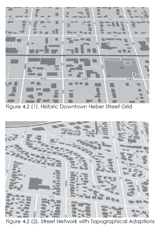
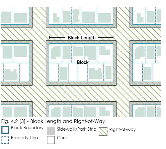


18.21.040.4.3 Intersections
4.3 Intersections
1. See Table 4.3(1) for approved intersection types. (Page 40)
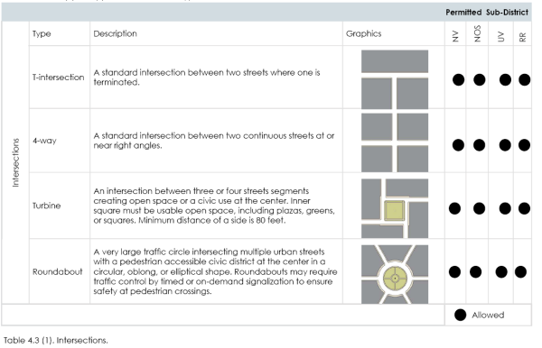
18.21.040.4.4 On-Street Parking
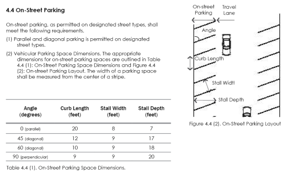
18.21.040.4.5 Bicycle Facilities
4.5 Bicycle Facilities
All bicycle accommodations shall be coordinated with the City’s trail plan. The following types of bicycle accommodations are permitted:
(1) Cycle Track. A cycle track is a separate on-road bicycle facility that is typically adjacent to, but physically separated from, vehicular traffic and parking by a barrier.
(2) Dedicated Bicycle Lane. Dedicated bicycle lanes are striped lanes on the outside of the outermost travel lanes that are designated for only bicycle use. This lane occurs on both sides of the street and shall be 5 to 6 feet wide.
(3) Designated Shared Lane. A designated shared lane is a lane that is shared between vehicles and bicycles. This lane is typically wider than a standard vehicular lane, a minimum 13 feet, in order to accommodate both types of users. It includes a painted bicycle marker combined with a double arrow (known as a “sharrow”). This improvement occurs in both directions.
(4) Shared Lane. A shared lane refers to a street that does not have bicycle lanes or a designated shared lane, but the speed and configuration of the street is such that bicycles could comfortably share lanes with traffic.
(5) Separate trail pathway. A 10-12-foot wide multi-purpose paved
trail separate from the street or highway.
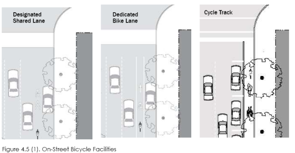
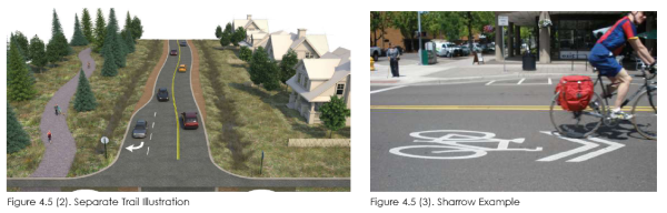
18.21.040.4.6 Residential/Minor Local
4.6 RESIDENTIAL/MINOR LOCAL
1. Intent The residential street is a low capacity street designed for slow speeds with a standard right-of-way. It primarily serves those residences or businesses directly adjacent to it. Refer to the typical plan and section, Figure 4.6 (2).
2. General Requirements The neighborhood street shall be developed using the standards in Table 4.6 (1).
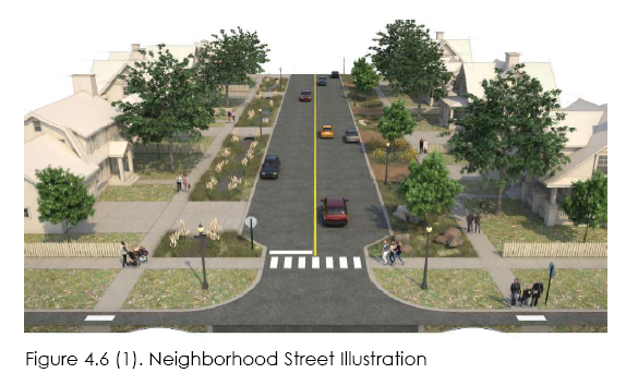
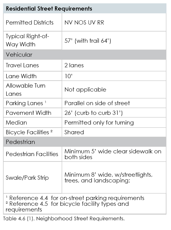
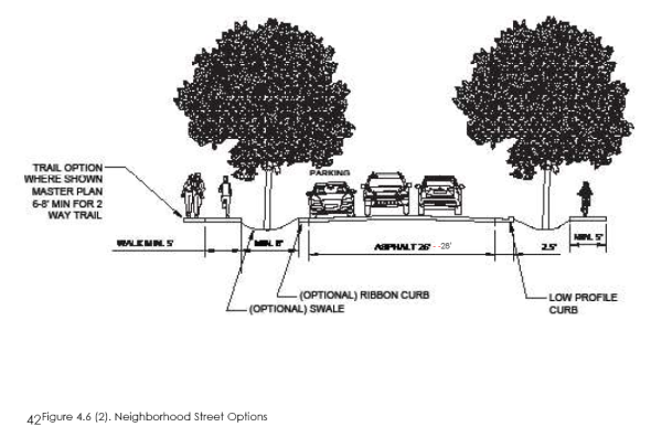
18.21.040.4.7 Residential/Major Local
4.7 RESIDENTIAL/MAJOR LOCAL
1. Intent
The residential street is a low capacity street designed for slow speeds with a standard right-of-way. It primarily serves those residences in the mountain and hillside areas and higher density multi-family areas. Refer to the typical plan and section, Figure 4.7 (1).
2. General Requirements
The complete street cross section and plan shall be
developed using the standards in Table 4.7 (1).
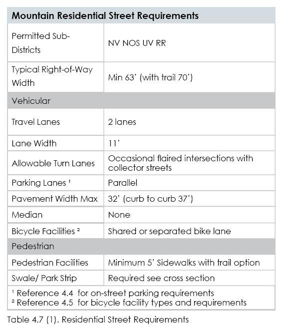
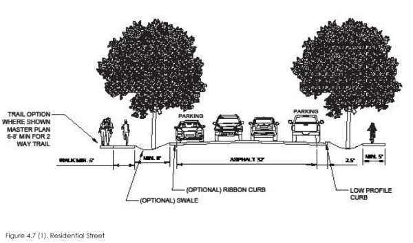
18.21.040.4.8 Village Center Street
4.8 Village Center Street
1. Intent
The village center street is designed first for pedestrians, buildings, and street life and second for vehicular traffic, see Figure 4.8 (1). The street is intended for slow speeds and high pedestrian traffic. Sidewalks are wide and have the capacity for on-street dining, shopping, and street life.
2. General Requirements
The complete street cross section and plan shall be
developed using the standards in Table 4.8 (1).
Benches for patrons shall be located perpendicular to the
street or adjacent to the building facing the street and
may be designed as part of a planter box. Concept and
construction drawings shall include street, sidewalks, trees,
street lights, tree grates, bike racks, trash receptacles, and
street furniture. Bulb-outs (curb extension) are required at midblock
crossings and intersections.
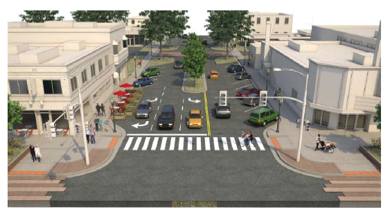
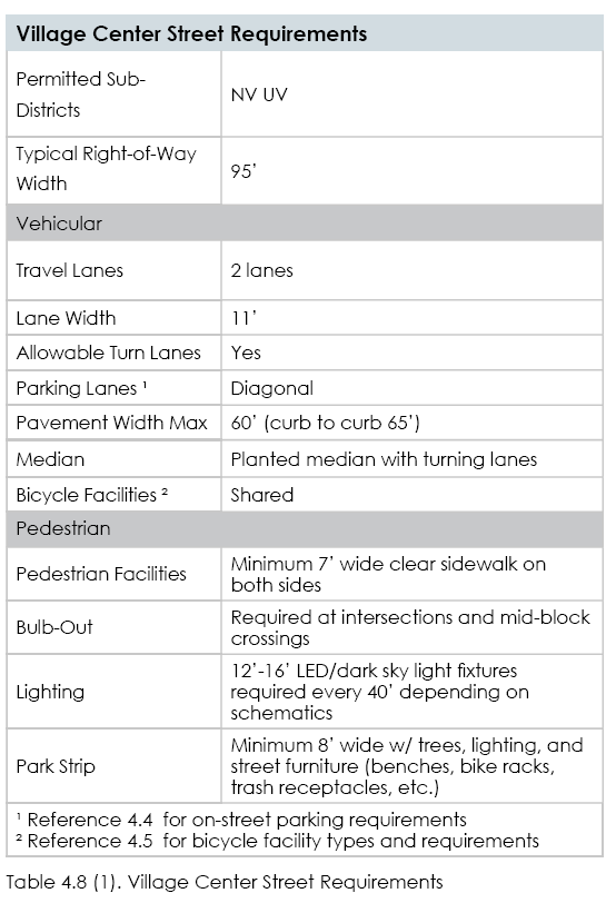
18.21.040.4.9 Neighbor Connector (Major Collector)
4.9 Village Connector (Major Collector) (Table and Figure on page 45)
1. Intent
The village connector street is a mid-range capacity street
designed for moderate speeds, with a standard right-ofway.
It primarily serves to connect the North Village and the
University Village areas and provides an alternate route to
state highways. Refer to the typical plan and section, Figure
4.9 (1).
2. General Requirements
The complete street cross section and plan shall be
developed using the standards in Table 4.9(1).
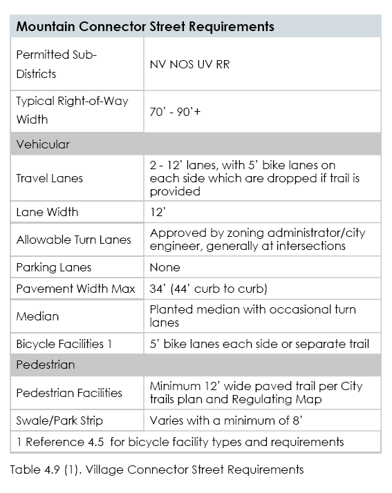
18.21.040.4.10 Neighbor Connector (Minor Collector)
4.10 Neighbor Connector (Minor Collector) (Table and figure on page 46) 1. Intent The neighborhood connector street is a mid-range capacity street designed for moderate speeds, with a standard rightof- way. It primarily serves to connect neighborhoods and those residences in the mountain and hillside areas. It also provides an alternate route to state highways. Refer to the typical plan and section, Figure 4.9 (1). 2. General Requirements The complete street cross section and plan shall be developed using the standards in Table 4.9(1).
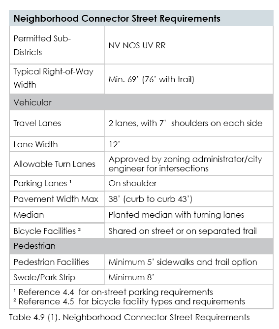
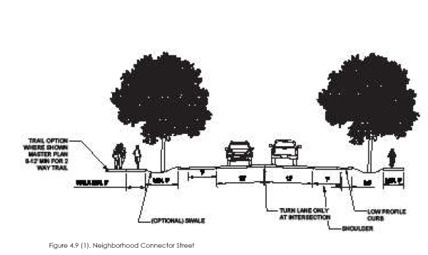
.18.21.050.5.1 Stormwater In Open Spaces
5.1 Stormwater in Open Spaces
Stormwater management practices, such as storage and
retention facilities, may be integrated into open spaces and
utilized to meet stormwater requirements for surrounding parcels.
(1) Stormwater Features. Stormwater features may be designed as natural amenities within a park (up to 20% of park land with parks and zoning administrator approval); however, ball and playing fields, courts, and playgrounds shall not be used for stormwater facilities. Stormwater features shall not be fenced and shall not impede public use of the land they occupy. Stormwater is anticipated to be accommodated on site to the greatest extent possible but is also suggested for gully crossings and within the scenic buffer where a greater percentage is allowed.
(2) Qualified Professional. A qualified landscape design
professional, such as a landscape architect, shall be utilized
to incorporate stormwater features into the design of the
open spaces.
18.21.050.5.2 Park And Open Space Requirements
| PARK AND OPEN SPACE AMENITIES | |
| BASIC AMENITY | REQUIREMENTS |
| Park Bench | 1 per 1/4 mile of paved or gravel trail. 4 per
first 1/2 acre and 2 additional per acre for
Urban Gathering Places, Local, and larger
parks |
| Water Stations | Minimum 1 per Urban Gathering Places.
1 per park amenity node(pavillions, bathrooms,
etc.) for larger parks |
| Pavilion | Minimum one per Plaza, Square, Local Parks
(15 person size), 2 per 3 acres of park for
Neighborhood/Community Parks (30 person) |
| Playground | Minimum one per Local and 1 per 10 acres
for larger parks |
| Picnic Area | Minimum 1 per Local and larger parks.
Minimum 4 tables, 2 barbeques, shade, hard
surfacing |
| Restroom | 1 per Neighborhood and larger parks (interior
&exterior lighting) |
| AMENITY OPTIONS | |
| Baseball Field | 1 Baseball Field |
| Softball Field | 1 Softball Field |
| Passive Lawn | Well graded 1/2 acre of turf grass lawn with
5-10 large park trees per acre |
| SPORTS FIELD | 1 multi Sport Field (soccer, lacrosse, rugby, etc.) |
| Tennis Courts | 2 Tennis Court |
| Pickleball Courts | 4 Pickleball Courts |
| Outdoor Basketball | 1 Outdoor Concrete Basketball Court |
| Outdoor Pool | 1 Outdoor Pool |
| Rec Center | 1 Recreation Center |
| Community Center | 1 Community Center |
| TRAIL OPTIONS | See Parks and Trails Master Plan for standards |
| Trail Head | 1 Trailhead Sign and 10 Parking Stalls. 1 water
station to include equestrian water access. |
| Fitness System Nodes | 1 per 1/4 mile includes a combination of
physical/active stations and activity signs |
| On Trail Sign | Trail directional sign at all trail intersections |
Table 5.2 (1). Park and Open Space Amenities
5.2 Park and Open Space Requirements (Table and figures on page 49)
(1) After identifying (or delineating in the case of wetlands) any sensitive lands as defined by section 5.16, and reviewing the Community Design Map, as part of the design process of a development, and as part of the concept plan submission, each development shall include a conceptual design to assess how the development will meet the required park and open space percentages in table 5.1 (1).
(2) For the required percentage of Traditional Parks, the designer shall choose one or more park types from the parks described in 5.6 to 5.12. Each of those park types describes minimum sizes and features that shall be included in the park development. In addition, amenity options are included. Water Stations are defined as providing options for humans, bottle filling, and dogs. For multi-family projects with under 50 units one additional different amenity option shall be added to the selected park type. For multi family projects with 51 to 100, two additional different amenity options shall be added to the selected park. For developments over 101 units four additional different amenity options shall be added to the selected park type.
(3) To meet the percentage requirements for the Open Space system found in table 5.1.(1), designers shall use the open space types shown in sections 5.13 to 5.15. Such open spaces shall include the features shown in those sections and any trail shown on the Community Design Map shall be constructed using the guidance of Chapter 17.30, and shall be built by the development to connect to adjacent properties.
(4) The Community Development, Trails Committee, Parks and Public Works staff will evaluate proposals for system-wide issues and regional demands. Where larger traditional parks and open spaces can be created by physical connections of over 100’ that join individual property parks and open spaces with neighboring properties, a 5% reduction in the total minimum requirement in Table 5.1 (1) is permitted. A fee-in-lieu (see 6 below) has been established as an option for properties determined to have sites unsuitable to meet park and open space system functions.
(5) The corresponding park and open spaces shall be completed as shown on the approved plans as each phase is completed. Trails shall be constructed concurrently with roads in each phase. Scenic buffer trail is considered part of the first phase, but may be waived with a fee-in-lieu payment.
(6) Fee-in-lieu substitutions are encouraged for the benefit of the NVOZ area by application to the Community Development Director, under the following circumstances: Cash in-lieu: the City may determine that in certain situations, accepting cash as an in-lieu substitution, where it can be shown that acceptance of those funds, is more effective by creating parkand/or trail improvements
18.21.050.5.6 Urban Gathering Place - Plaza
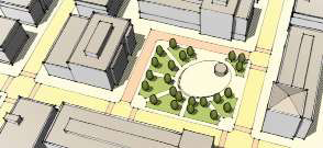
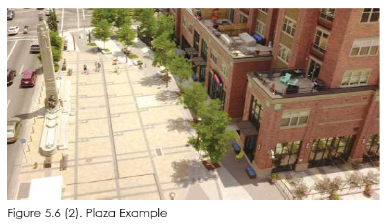 5.6 Urban Gathering Place - Plaza
1. Intent: provide a formal park or open space of medium
scale to serve as a gathering place for civic, social, and
commercial purposes. Plazas are required in the Villages. The
plaza may contain a greater amount of impervious coverage
than any other open space type. Special features, such as
fountains and public art installations, are encouraged.
Table 5.6 (1) Plaza Requirement
| PLAZA REQUIREMENTS | |
| (1) DIMENSIONS | |
| Minimum Size (square feet) | 5000 SF |
| Minimum % of Vehicular ROW Frontage | 25% |
| (2) ADJACENT PARCELS | |
| Frontage Orientation of Adjacent Parcels | Front or Corner Side |
| (3) Improvements | |
| Designated Sports Fields Permitted | Not Permitted |
| Playgrounds Permitted | Not Permitted |
| Fully Enclosed Structures Permitted | Permitted; maximum
10% of area |
| Maximum Impervious + Semi-Pervious
Surface | minimum: 40%
maximum: 80% + 10% |
| Maximum % of Open Water | 50% |
| (4) AMENITY REQUIREMENTS | |
| Required Basic Amenities | Yes |
| Required Amenities Options | No |
18.21.050.5.7 Urban Gathering Place - Square
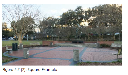
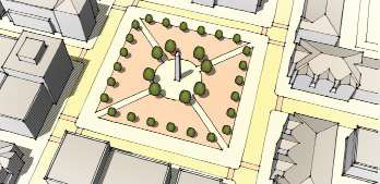
5.7 Urban Gathering Place - Square
1. Intent: to provide a formal park or open space of
medium scale to serve as a gathering place for civic,
social, and commercial purposes. Squares are rectilinear
in shape and are bordered on all sides by a vehicular
right-of-way, which, together with building facades,
creates its definition.
Table 5.7 (1) Square Requirement
| 2. SQUARE REQUIREMENTS | |
| (1) DIMENSIONS | |
| Minimum Size (acres) | 0.25 |
| Minimum Dimension (feet) | 80' |
| Minimum % of Vehicular ROW
Frontage Required | 25% |
| (2) ADJACENT PARCELS | |
| Frontage Orientation of Adjacent
Parcels | Front or Corner Side |
| (3) IMPROVEMENTS | |
| Designated Sports Fields Permitted | Not Permitted |
| Playgrounds Permitted | Not Permitted |
| Fully Enclosed Structures Permitted | Permitted; maximum 5%
of area |
| Maximum Impervious + Semi-Pervious
Surface | 40% + 20% |
| Maximum % of Open Water | 30% |
| (4) Amenity Requirements | |
| Required Basic Amenities | Yes |
| Required Amenities Options | No |
18.21.050.5.8 Urban Gathering Place - Courtyard
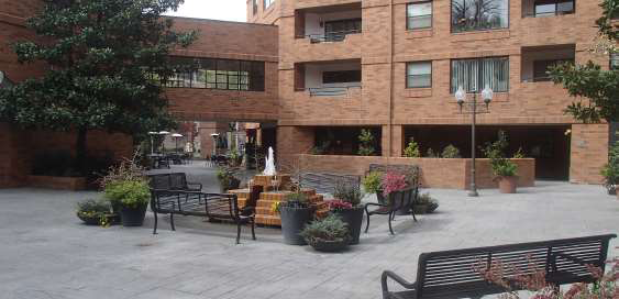
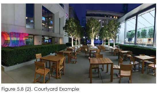 5.8 Urban Gathering Place - Courtyard
1. Intent: Courtyards provide a more intimate spatial experience
away from streets within residential or mixed-use environments.
They can be formal, paved spaces framed by buildings or restful,
garden spaces that can be experienced visually from within
building spaces, such as offices, retail shops, or residences.
Building facades, generally define these spaces.
Table 5.8 (1). Courtyard Requirements
| 2. Courtyard Requirements | |
| (1) Dimensions | |
| Minimum Size (Square Feet) | 1000 SF |
| Minimum Dimensions (Feet) | 50' |
Minimum % of Vehicular ROW Frontage Required | NA |
| (2) Adjacent Parcels | |
| Frontage Orientation of Adjacent Parcels | Front or corner side |
| (3) Improvements | |
| Designated Sports Fields Permitted | Not permitted |
| Playgrounds Permitted | Not permitted |
| Fully Enclosed Structures Permitted | Permitted; Maximum 10% of area |
| Maximum impervious + Semi-Pervious Surface | 80% + 20% |
| Maximum % of Open Water | 10% |
| (4) Amenity Requirements | |
| Required Basic Amenities | Yes |
| Required Amenities Options | No |
18.21.050.5.9 Local Parks - Commons/Green
5.9 Local Parks - Commons/Green
1. Intent: To provide informal, small- to medium-scale active or passive recreation for neighborhood residents within walking distance, mainly fronted by streets.
Table 5.9 (1). Common/Green Requirements
| 2. Commons/Green Requirements | |
| (1) Dimensions | |
| Minimum Size (acres) | 0.25 |
| Minimum Dimension (feet) | 45' |
| Minimum % of Vehicular ROW Frontage
Required | 25% |
| (2) Adjacent Parcels | |
| Frontage Orientation of Adjacent
Parcels | Rear, front or corner side |
| (3) Improvements | |
| Designated Sports Fields Permitted | Not Permitted |
| Playgrounds Permitted | Permitted |
| Fully Enclosed Structures Permitted | Not Permitted |
| Maximum Impervious + Semi-Pervious
Surface | 20% + 15% |
| Maximum % of Open Water | 30% |
| (4) Amenity Requirements | |
| Required Basic Amenities | Yes |
| Required Amenities Options | No |
18.21.050.5.10 Local Parks - Pocket Park
5.10 Local Parks - Pocket Park
1. Intent: To provide small scale, primarily landscaped active
or passive recreation and gathering space for neighborhood
residents within walking distance.
| 2. Pocket Park Requirements | |
| (1) Dimensions | |
| Minimum Size (acres) | 010 |
| Minimum Dimension (feet) | None |
| Minimum % of Vehicular ROW
Frontage Required | 30% |
| (2) Adjacent Parcels | |
| Frontage Orientation of Adjacent
Parcels | Any |
| (3) Improvements | |
| Designated Sports Fields Permitted | Not Permitted |
| Playgrounds Permitted | Permitted |
| Fully Enclosed Structures Permitted | Not Permitted |
| Maximum Impervious + Semi-
Pervious Surface | 30% + 10% |
| Maximum % of Open Water | 30% |
| (4) Amenity Requirements | |
| Required Basic Amenities | Yes |
| Required Amenities Options | No |
18.21.050.5.11 Neighborhood/Community Parks
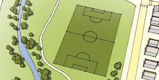
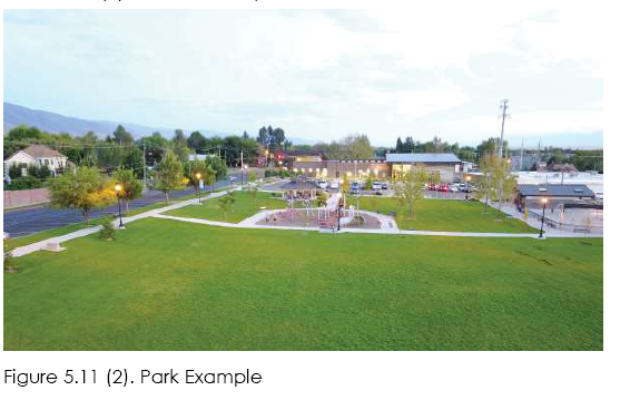
5.11 Neighborhood/Community Parks
1. Intent: To provide informal active and passive large-scale
recreational amenities to local residents and the greater region.
Parks have primarily natural plantings and are frequently created
around an existing natural feature such as a water body or stands
of trees. Parks may include water features.
Table 5.11 (1) N/C Park Requirements
| 2. Neighborhood/Community Park Requirements | |
| (1) Dimensions | |
| Minimum Size (acres) | Neighborhood 3
Community 10 |
| Minimum Dimension (feet) | 200' |
| Minimum % of Vehicular ROW Frontage
Required | 30%; up to 5 acres;
20% over 5 acres |
| (2) Adjacent Parcels | |
| Frontage Orientation of Adjacent
Parcels | Any |
| (3) Improvements | |
| Designated Sports Fields Permitted | Permitted |
| Playgrounds Permitted | Permitted |
| Fully Enclosed Structures Permitted | Permitted, minimum
5-acre park required |
| Maximum Impervious + Semi-Pervious
Surface | 20% + 10% |
| Maximum % of Open Water | 30% |
| (4) Amenity Requirements | |
| Required Basic Amenities | Yes |
| Required Amenities Options | 1 per Acre |
18.21.050.5.12 Community Gardens
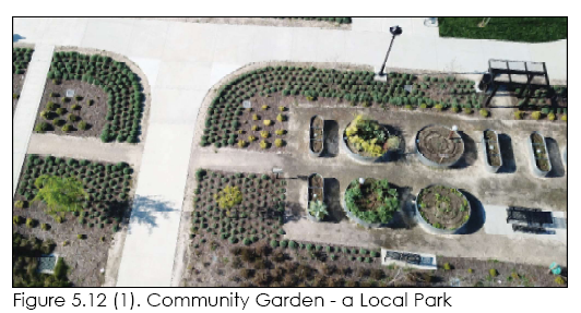
5.12 Community Gardens
1. Intent: Space programmed specifically for gardening. Located
in the center of a neighborhood to provide convenient and
safe access; may be combined with pocket park. Orchards and
vineyards may also be included in this category of open spaces,
as long as they are operated as a non-profit organization that
provides produce to the local community, and they are not a
commercial, agricultural use. Irrigation sources must be provided,
and the garden must be locally managed and maintained.
Table 5.12 (1). Community Gardens Requirements
| 2. Community Gardens Requirements | |
| (1) Dimensions | |
| Minimum Size (square feet) | 2000SF |
| Minimum Dimension (feet) | 50' |
| Minimum % of Vehicular ROW
Frontage Required | NA |
| (2) Adjacent Parcels | |
| Frontage Orientation of Adjacent
Parcels | Front or corner side |
| (3) Improvements | |
| Designated Sports Fields Permitted | Not Permitted |
| Playgrounds Permitted | Not permitted |
| Fully Enclosed Structures Permitted | Permitted; maximum 10% of area |
| Maximum Impervious + Semi-Pervious
Surface | 20% + 20% |
| Maximum % of Open Water | NA |
| (4) Amenity Requirements | |
| Required Basic Amenities | No |
| Required Amenities Options | No |
18.21.050.5.13 Trail Corridors Along Major Streets And Canals
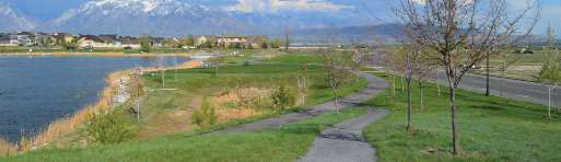
5.13 Trail Corridors Along Major Streets and Canals
1. Intent: To provide paved pathways within primarily natural,
linear open spaces that serve to enhance connectivity between
open spaces, villages, and neighborhoods. These trail corridors
are linear open spaces that follow streets and canals. A trail
corridor may border other open space/park types. Trail corridors
may count for up to 10% of total park requirements. All trails
shall generally follow the alignments on the Community Design
Map and are required if located on development property. Trail
construction as per 17.30, consult the Parks and Trails Master
Plan,and street and canal trails shall meet ADA requirements.
Table 5.13 (1) Trail Corridor Requirements
| 2. Trail Corridor Requirements | |
| (2) Required Spacing | |
| Required on all drainage corridors, canal corridors, and US
Highway 32 and 40. | |
| (3) Improvements | |
| Multi-use 8’ to 12’ Wide Trail | Required |
| Playgrounds Permitted | Permitted |
| (1) Dimensions | |
| Minimum Dimension Width (feet) | Minimum 30’
recommended
average width 50’ |
| Minimum % of Vehicular ROW
Frontage Required | 0%; 1 access point
required per half-mile
length, minimum 20’
width |
| Trail Surface Options | Asphalt, concrete, |
| Maximum Impervious + Semi-Pervious
Surface | 20% + 10% |
| Maximum % of Open Water | 30% |
| (4) Amenity Requirements | |
| Required Basic Amenities | Yes |
| Trail Options | Yes |
18.21.050.5.14 Natural Trail
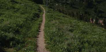

5.14 Natural Trail
1. A natural trail is an unimproved, or semi-improved backcountry
trail that connects natural areas and mountain recreation
areas. Trail users could include pedestrians and bicyclists. A trail
provides an important place for active recreation and serves as
the backbone for regional pedestrian and biking connectivity.
Trails within traditional parks, and natural open spaces, shall be
composed of low impact surface materials, so there is minimal
impact to area environs. Pedestrian amenities can add to
recreational opportunities, particularly in key locations and at
intersections with other transportation networks. Trailheads and
trails can include drinking fountains, scenic viewpoints, fitness
stations, and directional signs. Trails shall generally align with
the Community Design Map. All trails shown on the Community
Design Map are required if located on development property.
Trail construction as per 17.30 and Parks and Trails Master Plan.
Table 5.14 (1). Natural Trail Requirements
| 2. Natural Trail Requirements | |
| (1) Dimensions | |
| Minimum/Maximum Size (acres) | NA |
| Minimum Dimension Width (feet) | Minimum clear surface width 2-6 feet; IMBA standard in Title 17.30 |
| Minimum % of Vehicular ROW
Frontage Required | 0%; 1 access point
required per half-mile
length, minimum |
| (2) Required Spacing | |
| Required in drainage corridors to access the mountains | |
| (3) Improvements | |
| Natural/Soil 3’ Wide Trail | Required |
| Trail Surface Options | Soil |
| (4) Amenity Requirements | |
| Required Basic Amenities | No |
| Trail Options | Yes (as per MDA) |
18.21.050.5.15 Natural Open Space
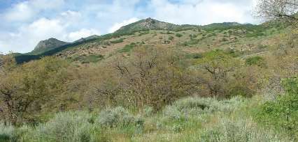
5.15 Natural Open Space
1. Natural open space areas may occur at the edges of
development. These may be areas of hillsides, sagebrush,
scrub oak and maple, or rangelands that lie outside of the
development limits of the NVOZ or intermingle with development.
Selection of an area for preservation may be identified in an
MDA or during the development process. Areas set aside for
preservation may be preserved through formal Open Space or
Preservation Easements or by definition within an MDA or by a
recorded deed restriction. Trails may occur in these areas with
low impact materials so there is minimal impact to the existing
landform and vegetated patterns. Developed trail heads at key
locations may contain other facilities to support recreational
opportunities, as per the Parks and Trails Master Plan. Trail heads
may include bathrooms, parking, pavilions, trash receptacles, dog
related amenities, equestrian amenities, and casual seating.
Table 5.15 Natural Open Space Requirements
| 2. Natural Open Space Requirements | |
(1) Dimensions | |
| Minimum/Maximum Size (acres) | 5 |
| Maximum Size (acres) | None |
| Minimum Dimension (feet) | 100' |
| Minimum % of Vehicular ROW
Frontage Required | 0%; 1 access point
required per quarter-mile
length |
| (2) Adjacent Parcels | |
| Permitted Districts | All |
| (3) Improvements | |
| Playgrounds Permitted | Permitted at trailheads only |
| Fully Enclosed Structures Permitted | Permitted at trailheads only, minimum 5-acre park required |
| Uses | Trails, nature preserve, playground |
| (4) Amenity Requirements | |
| Required Basic Amenities | No |
| Trail Option | Yes (as per MDA) |
18.21.050.5.16 Sensitive Lands
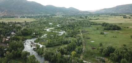
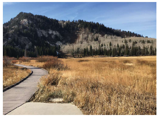
5.16 Sensitive Lands
1. Sensitive lands contain characteristics that can influence or limit
development patterns through physical or regulatory restrictions.
The types of lands represented in this typology may include steep
slopes, rock outcroppings, wetlands, intermittent or constant flow
stream corridors, ridgelines, springs, gullies, species protection,
animal migration routes, and oak and maple vegetation areas.
Soils and geotechnical considerations, such as fault lines, soil
types, and depth to bedrock, may also be factors to consider
when determining the extent of sensitive lands. Critical viewsheds
and highway corridor buffers, may also be factors that determine
the extent of sensitive land designations within a particular
development site. Potential wildfire buffers shall also be analyzed
and mitigated. Villages are excluded from the oak and maple
vegetation requirement and any identified wildlife corridors may
be replaced with a highly landscaped trail corridor, reflecting the
general direction of the identified wildlife corridor. Preservation of
these areas in a natural state is required and shall be designated
in the Concept Plan submittal, but may be modified after a
consideration of regulatory controls, cost controls, or design/
amenity-based strategies. Trade-offs may be considered for oak
and maple vegetation areas during the planning process.
Table 5.16 (1) Sensitive Lands Requirements
| 2. Sensitive Lands Requirements | |
| (1) Dimensions | |
| Minimum/Maximum Size (acres) | As determined though the Concept Plan |
| Minimum Dimension (feet) | 50’minimum width. Additional
25’ peripheral buffers from
wetland and stream/spring
areas and variable buffers for
wild re mitigation are required.
Adjacent to the Provo River
and Rock Creek a
100’ buffer is required and
potential groundwater
contaminating sources shall be
setback an additional 100’. |
| (2) Preservation | |
| Areas required to be preserved | As per paragraph 1. Scrub oak
and Big Tooth Maple natural
groves to be preserved if
larger than 5000 square feet,
especially as part of the natural
gullies |
| (3) Improvements | |
| Designated Sports Fields | Not Permitted |
| Playgrounds | Not Permitted |
| Fully Enclosed Structures | Permitted, minimum 5-acre
park or open space required |
| Trails | Required for access |
18.21.060.6.1 General Requirements
6.1 General Requirements
1. Intent
The landscape standards outlined in this section are designed to meet the following set of goals:
(1) To provide for healthy, long-living street trees within all public ways to improve the appearance of streets and to create a buffer (park strip) between pedestrian and vehicular travel lanes.
(2) To increase the compatibility of adjacent uses and minimize the adverse impacts created by adjoining or neighboring uses.
(3) To promote the prudent use of water and energy resources by achieving and maintaining sustainable, water-wise, functional landscapes.
(4) To shade large expanses of pavement and reduce the urban heat island effect.
(5) To create pleasant neighborhood appearance with wildlife friendly landscapes suitable to on-site low impact development (LID) stormwater percolation techniques.
2. Applicability
Landscaping, trees, and buffers shall be installed as detailed in this section.
(1) General Compliance.
(a) Application of this section to existing uses shall occur when an alteration to an existing principal or accessory structure occurs that results in a change of 15% or more in the structure’s gross floor area.
(b) All new development shall comply with this section.
(2) Buffers. Landscape buffers are required according to the provisions in this section with the following exceptions.
(a) Shared Driveways. Buffers shall not be required along a property line where a curb cut or aisle is shared between two adjoining lots.
(b) Points of Access. Buffering is not required at driveways or other points of access to a lot.
(3) Temporary Uses. These provisions do not apply to temporary uses, unless determined otherwise by the City.
(4) Landscaped rooftop gardens count toward required landscape areas and plant requirements.
(5) The required amount of landscape is 10% of the gross
land and site of the project. The private property
landscape area does not count towards the required
open space, unless it is publicly accessible according to
Section 5.
18.21.060.6.2 Installation Of Landscape
6.2 Installation of Landscape
1. Intent The following provisions aid in ensuring that all required landscaping is installed and maintained properly.
2. Applicability These provisions apply to landscape installation as required by this section.
The installation of landscaping shall adhere to the following standards.
(1) National Standards. Best management practices and procedures according to the nationally accepted standards shall be practiced.
(a) Installation. All landscaping and trees shall be installed in conformance with the practices and procedures established by the most recent edition of the American Standard for Nursery Stock (ANSI Z60.1) as published by the American Association of Nurserymen.
(b) Maintenance and Protection. All landscaping and trees shall be maintained, including provisions for pruning, fertilizing, support systems, lighting protection, and safety.
(2) Installation. Landscaping for all building types, except single family dwellings, shall be installed prior to the issuance of a certificate of occupancy.
(a) If seasonal conditions preclude the complete installation, as an option, a cash escrow or irrevocable letter of credit, equal to 1.1 times the installation costs as estimated by a qualified professional, shall be completed and posted with the City. When guaranteed, such landscaping shall be installed within nine months of the issuance of the cash escrow, or letter of credit may be forfeited. Wildlife friendly landscapes for single family dwellings shall be fully installed within six months of the issuance of a certificate of occupancy for all landscaped areas adjacent to a street. For guidance on wildlife friendly landscapes see the Utah Department of Natural Resources study - https://wildlife.utah. gov/pdf/landscapingforwildlife.pdf.
(b) If seasonal conditions preclude the complete installation, as an option, a cash escrow or irrevocable letter of credit, equal to 1.1 times the installation costs as estimated by a qualified professional, shall be completed and posted with the City. When guaranteed, such landscaping shall be installed within nine months of the issuance of the cash escrow, or letter of credit may be forfeited.
(3) Plant Requirements. Plant material shall be sized according to Table 6.2 (1) at the time of installation, unless otherwise noted in this section. Water conservation and stewardship is very important to the City.
(a) Tree Requirements. 20 trees are required per one acre of project. Street trees may count toward this requirement.
(b) Shrub Requirements. 50 shrubs are required per 1 acre of project. Two ornamental grasses or perennials count as one shrub for up to 60% of required shrubs.
(c) Plant material shall be placed around the perimeter of the building footprint in a 4-foot minimum planting strip, with the exception of entrances, utilities, and where setbacks are less than 4 feet.
(d) The maximum percentage of landscape area that may be turf grass is 60%, and the remaining landscape area should be planter bed areas or xeric/water-wise plantings. Parks and sports fields do not have a limited turf grass requirement. Planting selection should be water wise, and it is recommended to select plants from the water-wise list at https://waterwiseplants.utah.gov/.
(e) Twenty-five (25%) of required plants (see 6.2 (3) a & b)
shall be wildlife friendly landscape plants from the list
found at Utah Department of Natural Resources https://
wildlife.utah.gov/pdf/landscapingforwildlife.pdf or
approved list by Zoning Administrator.
(4) Condition of Landscape Materials. The landscaping materials used shall be:
(a) Healthy and hardy with a good root system.
(b) Chosen for its form, texture, color, fruit, pattern of growth, and suitability to local conditions.
(c) Tolerant of the natural and man-made environment, including tolerant of drought, heat, wind, salt, and pollution.
(d) Appropriate for the conditions of the site, including slope, water table, and soil type.
(e) Protected from damage by grates, pavers, or other measures in Villages.
(f) Plants that will not cause a nuisance or have negative impacts on an adjacent property.
(g) Species native or naturalized to the Wasatch Back, whenever possible.
(5) Compost, Mulch, and Organic Matter. Compost, mulch, and organic matter may be utilized within the soil mix to reduce the need for fertilizers and increase water retention.
(6) Establishment. All installed plant material shall be
fully maintained until established, including watering,
fertilization, and replacement as necessary.
4. Ground Plane Vegetation
All unpaved areas shall be covered by one of the following:
(1) Planting Beds.
(a) Planting beds may include shrubs, ornamental grasses, ground cover, vines, annuals, or perennials.
(b) Nonliving materials, such as colored gravel or mulch, are permitted for up to 50% of a bed area.
(c) Annual beds must be maintained seasonally, replanting as necessary.
(2) Grass. Seeded, plugged, or sodded grass may be planted throughout landscaped areas.
(a) Grass shall be established within 90 days of planting, or
the area must be reseeded, re-plugged, or resodded.
5. Tree Installations
This section applies to all trees, including street trees (refer to the list of permitted street tree types, available in this document).
(1) Tree Measurement. New trees shall be measured at 6 inches
above the mean grade of the tree’s trunk when 4-inch
caliper or less and twelve inches for tree trunks above 4
inches, and as noted as caliper inches throughout this
ordinance.
(2) Tree Maintenance. Tree trimming, fertilization, and other similar work shall be performed by or under the management of an ISA-certified arborist.
(3) Tree Size. All trees shall meet the requirements specified in table 6.2(1).
(4) Permeable Surface. For each tree preserved or planted, a minimum amount of permeable surface area is recommended, unless otherwise stated in this ordinance.
(a) At least 50% of the future mature canopy limits of preserved trees should have a permeable surface. (b) Planted trees have a suggested minimum permeable area and soil volume based upon tree size; refer to Table 6.2 (2) for details.
(c) Permeable area for one tree cannot count toward that of another tree.
(5) Structural Soil. When the soil surface area (per Table 6.2 (2)) of a tree will extend below any pavement, structural soil is required underneath that pavement. Structural soil is a medium that can be compacted to pavement design and installation requirements while still permitting root growth. It is a mixture of gap-graded gravels (made of crushed stone), clay loam, and a hydrogel stabilizing agent to keep the mixture from separating. It provides an integrated, root-penetrable, high-strength pavement system that shifts design away from individual tree pits
Structural soil requirements are specifically needed for
parking lots, sidewalk plantings (NV and UV sub-districts),
and other hardscape planting areas.
6. Irrigation Systems Permanent irrigation, beyond establishment, is required and shall adhere to the following standards:
(1) All irrigation systems shall be designed to minimize the use of water.
(2) All irrigation systems shall be installed with an EPA Waterwise controller or approved equal and must be used according to directions to save water.
(3) The irrigation system shall provide sufficient coverage to all landscape areas, requiring a consistent water supply.
(4) The irrigation system shall not spray or irrigate impervious surfaces, including sidewalks, driveways, streets, and parking and loading areas.
(5) All systems shall be equipped with a back-flow prevention device.
(6) All mechanical systems, including controllers and back-flow prevention devices, shall be properly screened from public view.
(7) All irrigation plans shall be stamped by a professional
landscape architect or certified irrigation designer and
submitted to the City for review.
7. Maintenance of Landscape All landscaping shall be maintained in good condition at all times to ensure a healthy and orderly appearance.
(1) Required Landscape. All required landscape shall be maintained to adhere to all requirements of this ordinance.
(2) Replacing Unhealthy Landscaping. Unhealthy landscaping shall be replaced with healthy, live plants by the end of the next applicable growing season. This includes all plant material that shows dead branches over a minimum of 25% of the normal branching pattern.
(3) Maintenance Responsibility. The owner is responsible for the maintenance, repair, and replacement of all landscaping, screening, and edging required herein.
(4) Maintain Quality and Quantity. Maintenance shall preserve at least the same quantity, quality, and screening effectiveness as initially installed.
(5) Fences and Other Barriers. Fences, walls, and other barriers shall be maintained in good repair and free of rust, flaking paint, graffiti, and broken or damaged parts.
(6) Tree Topping. Tree topping is not permitted. When necessary, crown reduction thinning or pruning is permitted. Refer to 7.3.4(2) for clear branch height of street trees.
(7) City Inspection. All landscaped areas regulated by this
ordinance may be inspected by the City.
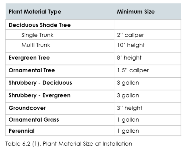
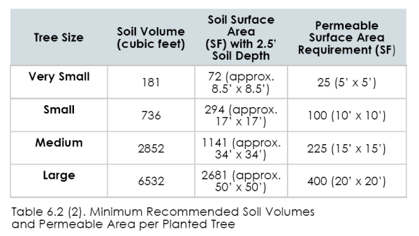
18.21.060.6.3 Street Trees And Streetscape Design
6.3 Street Trees and Streetscape Design
1. Intent To line all streets with a consistent and appropriate planting of trees, and to establish a tree canopy for environmental benefit and a sense of identity for all streets.
2. Applicability The requirements herein apply to all new development in all subdistricts.
3. Streetscape Design Submittal A consistent, theme-based, streetscape design shall be submitted for approval of all new streets within the development. At a minimum, the submittal shall include the following: all landscape plans shall be stamped by a professional landscape architect or certified irrigation designer.
(1) Street Trees. Trees meeting the minimum requirements of 6.3.4, below, shall be included in the streetscape design, with details related to tree pits; tree planting to meet the requirements of 6.2.5 Tree Installations.
(1) Sidewalk Pavement Design. Sidewalk paving materials and pattern shall be set for each street type (refer to 4.0 Street Types).
(2) Street Furnishings. At a minimum, benches, seatwalls, planters, planter fences, trash receptacles, and bicycle racks, shall be specified and quantities and locations listed for each street type (refer to 4.0 Street Types). Benches are required for streets identified as “Village Center Streets” in NV and UV Sub-districts.
(3) Landscape Design. Ground plane vegetation shall be designated for any landscape bed areas, planter areas, and tree wells.
(4) Lighting. Pedestrian and vehicular parking lot/street lighting shall be specified and locations and quantities noted. Street lighting shall be downward directed and shielded for dark sky compliance and comply with public works standards.
(5) Identity Elements. Any other elements designed to establish the identity of a neighborhood, such as unique lighting, distinct tree plantings, banners, pavement markers, artwork, or theme signage, shall be included in the concept design submittal.
(6) Park strips and street trees in NOS and RR zones may be planted using a native planting selection and pattern.
4. Minimum Street Tree Requirements The following standards apply to the installation of street trees:
(1) Exception. Street trees are not required on any alley.
(2) Clear Branch Height. Minimum clear branch height is 8 feet.
(3) Street Tree Type. Medium and large shade trees are required to be installed as street trees; see Table 6.3 (3) and (4).
(4) Street Tree Spacing. Street trees shall be planted as follows:
(a) Each single family lot is required to have minimum of one tree in the front yard. Medium trees shall be installed in a park strip less than 6 feet, and large trees shall be installed in park strips greater than 7 feet.
(b) Tree Spacing.
(i) Large trees must be spaced a minimum of 30 and a maximum of 60 feet on center.
(ii) Medium trees must be spaced a minimum of 20 and a maximum of 40 feet on center.
(c) Limited Distance between Curb and Sidewalk. Where the distance from the back of the curb to the edge of the right-of-way or property line is less than 9 feet and is intended to include a sidewalk, applicant shall work with the City to determine the appropriate tree species.
(5) Tree Wells. In village sub-districts, where the sidewalk extends from the back of curb to the property line, tree wells shall be utilized.
(a) For tree wells adjacent to sidewalks 5 feet wide or less, open pit is not permitted.
(i) The opening must be covered with a tree grate or pervious pavement.
(ii) The opening in a tree grate for the trunk must be expandable.
(6) Streets shall have the same tree species per block on both
sides of the streets with changes at intersections.
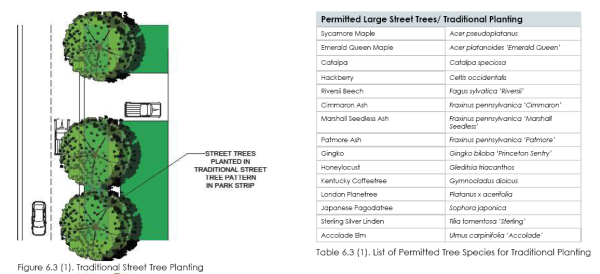
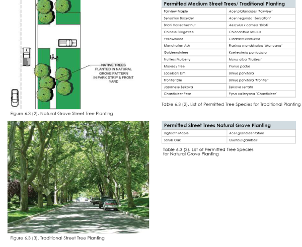
18.21.060.6.4 Street Frontage Buffer
6.4 Street Frontage Buffer
1. Intent and Applicability
(1) Intent. To lessen the visual impact of vehicular parking
areas visible from the street in all sub-districts.
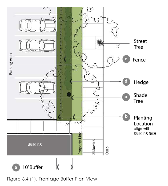
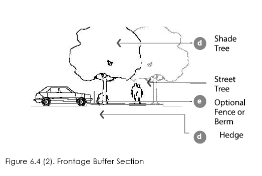
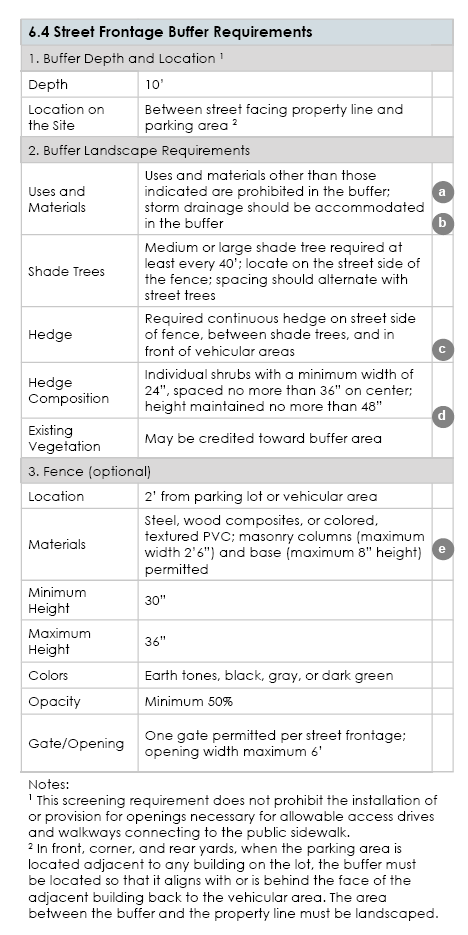
18.21.060.6.5 Side And Rear Buffer
6.5 Side and Rear Buffer
1. Intent and Applicability
(1) Intent. To minimize the impact that one zoning district may have on a neighboring district, and to provide a transition between districts.
(2) General Applicability. Applies to all directly adjoining properties; parking lots may and should directly adjoin.
(3) The frontage buffer may be used for storm water drainage
with a maximum depth of 1 foot and no more than a
2:1 slope on the edges. Such areas shall be creatively
landscaped with a combination of trees, shrubs, inert
mulches, boulders, etc.
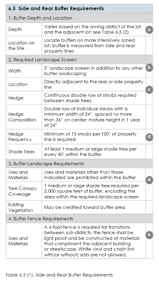
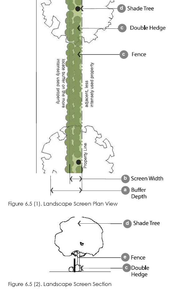
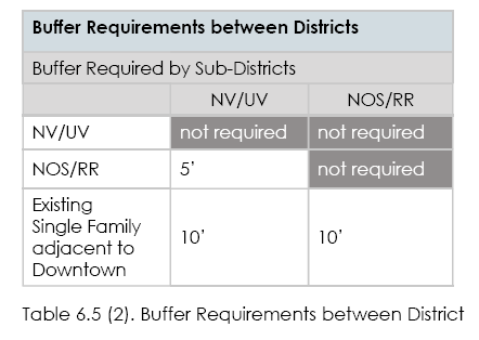
18.21.060.6.6 Interior Parking Lot Landscape Requirements
6.6 Interior Parking Lot Landscape Requirements
1. Intent and Applicability
(1) Intent. To provide shade, minimize paving and associated stormwater runoff, and improve the aesthetic look of parking lots.
(2) General Applicability. All sub-districts.
(3) Other Internal Parking Lot Areas. Internal areas not dedicated to parking or drives shall be landscaped with a minimum of one medium or large shade tree for the first 150 square feet and one medium or large shade tree for every 650 feet thereafter.
(4) Existing Vegetation. Existing vegetation may be credited
toward these requirements.
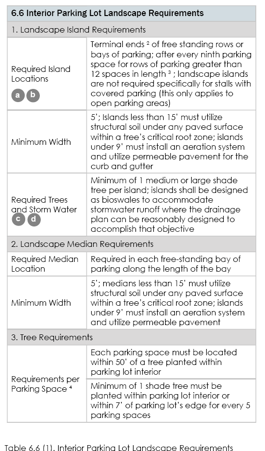
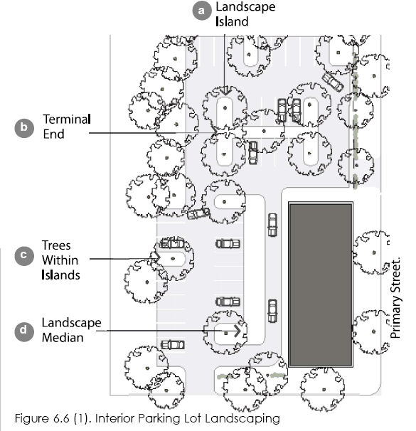
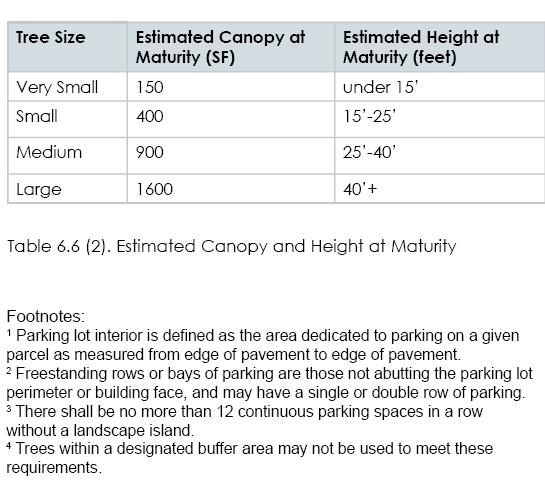
18.21.060.6.7 Landscape Screening
6.7 Landscape Screening
1. Intent and Applicability
(1) Intent. To reduce the visibility of open storage, refuse areas, and utility appurtenances from public areas and adjacent properties.
(2) General Applicability. All dumpsters, open storage, refuse areas, and utility appurtenances in all sub-districts.