
Heber City City Zoning Code
18.67 Sensitive
Lands
18.67.010 Sensitive Lands, Hazards, And Agricultural Land Notification
A. Purpose and Intent:
1. To preserve the distinctive features and the natural setting characteristic of Heber City and to promote development that is sensitive to the land. 2. To identify and document sensitive lands that shall be protected from development and to guide sensitive lands related open space designations in development proposals. 3. To identify certain hazardous conditions that require buffering, avoidance, or other engineering techniques to allow for safe beneficial development. 4. To give notice and promote an understanding between property owners with development proposals adjacent to agricultural uses of the characteristics of those agricultural uses. 5. To preserve the water quality of the underground aquifer. 6. To provide for the health, safety, welfare of the citizens, as well as protect urban and nonurban development, the good order and aesthetics of our municipality, and protection of property values per U.C.A. 10-9a-102(1).
B. Applicability. The requirements contained herein apply to subdivisions, and shall be extended to individual lots not requiring a subdivision process, or not previously subject to a subdivision process that included the requirements of this Chapter and/or processed after the date of adoption of this Chapter. In addition, any annexation proposal, Master Development Agreement, preliminary plans, and final plans shall include a sensitive lands identification analysis that addresses the requirements of this Ordinance. It is understood that such studies may find no sensitive lands exist. Concept plans and/or a pre-application meeting shall be required in the subdivision process when sensitive lands are identified within the development proposal. Any sensitive lands identified as a result of the requirements of this ordinance shall be recognized in the development proposal. Some sensitive lands cannot be mitigated and as such, development design shall avoid the identified sensitive lands areas. Such lands, shall be designated on the site plan or plat in a manner that permanently restricts the area from development.
C. Sensitive Lands defined. Sensitive Lands contain characteristics that can influence, modify, or limit development patterns through physical or regulatory restrictions. The types of lands represented in this typology include steep slopes, significant rock outcroppings, wetlands, avalanche zones, intermittent or constant flow stream corridors, ridgelines, springs, significant gullies, species protection, wildfire/urban interfaces, flood plains, and animal migration routes. Soils and geotechnical considerations, such as fault lines, soil types, and depth to bedrock, and shallow water table levels, may also reveal factors to consider for avoidance and/or design modifications when determining the extent of sensitive lands.
D. Identification required. Designation and preservation and/or mitigation of the identified Sensitive Lands features and their associated area(s) in their natural state is required and such sensitive lands shall be shown on site plans, and preliminary and final subdivision plats (applications on-line and at the City offices). It is the intent of these requirements to promote a development design that incorporates and integrates the sensitive lands into the development design process as valued aspects of that design.
E. Development Design Considerations.
1. All final plans shall include a grading plan to assure that the development minimizes land disturbance and conforms to the City Storm Water Design Manual. Storm drainage plans shall include system design to return filtered waters to the natural drainage channels, where applicable. 2. Geotechnical reports, required as per the Heber City Standards and Specifications, shall also include an analysis of the soil types and their potential for movement when additional water is applied, as may occur from landscape irrigation and/or impervious surface runoff. Geotechnical studies shall also identify (1) the depth to water table, and (2) potential fluctuations in seasonal water tables, if buildings with basements are to be constructed within the proposed development. 3. Underlying zone setbacks shall be adhered to, although larger setbacks may be required due to geotechnical mitigation strategies. 4. All lots shall include specific engineering designs to contain run off, erosion, and pollution on the subject property during construction and after construction. 5. Cuts and fills shall not exceed a 2 horizontal to 1 vertical slope. Retaining walls extending over 10’ in height shall include a landscaped terrace, a minimum of 4’ in width for every 10’ in height. Terraces may be created at lesser heights to meet slope related issues, but the minimum width for the terrace of 4’ shall be maintained for landscaping.
F. Development Prohibited. New subdivisions and new development shall avoid and preserve as undisturbed/natural open space the following areas:
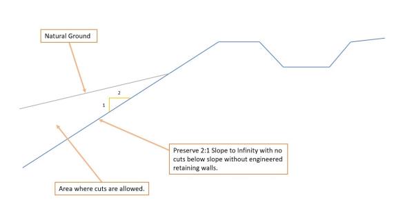
1. Steep slopes: Identify areas with average slopes ranging from 10% to 20%, from 20% to 30%, and over 30%. Natural slopes over 30% grade are considered to be Steep Slopes and shall be identified on a Topographic Map (2’ contours) of the project site. Residential and commercial structures are prohibited in areas with natural slopes greater than 30%, but such areas may be included within a lot boundary or used as open space (private or public.) When lots contain areas of steep slopes, the buildable area shall be a minimum of 4000 square feet below 30% natural grade and with a minimum width and length of 50 feet. Non-buildable steep slope areas of lots shall be identified on preliminary and final subdivision plats, with such information transferred to individual site plans. Roads, driveways, and trails are permitted to be built across natural slopes greater than 30% with approved geotechnical reports and engineering design addressing slope stability, retaining walls, and erosion prevention. Erosion control measures shall be installed to prevent materials flowing out onto adjacent trails, sidewalks and streets, adjacent fences and sensitive lands buffer areas. 2. Avalanche paths: Avalanche paths shall be identified, and development shall avoid such paths as recommended by a qualified Geotechnical Engineer. 3. Fault lines, scarps, landslides, rock outcroppings, rock-fall, and mud/debris flow areas: These topographical features shall be avoided and mitigated as recommended by a qualified Geotechnical Engineer. Determinations and mitigation techniques proposed that, when reviewed by the City Engineer, do not clearly resolve any identified issues may be subject to peer review at the City’s discretion. The developer shall pay for such additional studies/peer reviews and the City shall manage the funds. 4. Stream beds (including intermittent), gullies, flood channels, areas of springs, seeps and surface water: Pollution sources, including but not limited to septic tanks, fuel storage, livestock (including manure piles) and landfills, shall be setback at least 100 feet from the hydrologic feature. Additional vegetation may be required between the hydrologic features and development for erosion control (with limited herbicide use in natural corridors). Hydrologic features shall be buffered with a building setback of 20’ feet from the high water mark or edge of the feature, unless otherwise specified in the Storm Water Design Manual or an acceptable mitigation technique proposed by the applicant’s engineer and approved by the City Engineer. 5. Canals. Development shall avoid destabilizing the downhill portion of canals. No cuts shall be permitted below a 2:1 slope measured from the downhill bank of a canal without mitigation/safety strategies proposed by a geotechnical engineer. See graphic below “Canal Bank Stabilization”.
Canal Bank Stabilization
6. Identified wetlands: Wetlands shall be delineated using the Section 404 definition and procedures within the Clean Water Act. Protected wetlands shall be buffered with a minimum building setback of 25’ feet wide from the defined edge of the wetland or provide a study that includes a different technique to eliminate pollution/contamination of the wetland, to the City Engineer for review, modifications if needed, and/or approval. Areas considered to be potential pollution sources (see list in F (4) above) shall be setback 100’ from the identified wetlands. Additional vegetation may be required in these buffer areas for erosion control. 7. Wildfire Potential: Potential wildfire areas shall be assessed, and mitigation strategies applied, as per 15.04.010 D. 8. Culinary Water Source Protection. Public and private wells, and springs: Such areas shall be identified within the subject property and on adjacent properties within 100’. City required notification processes shall be followed. See Wellhead Protection ordinance 8.28. 9. Development above ridgelines shall follow the standards in Chapter 18.106, Ridgeline Protection.
G. Development Constraints for Certain Sensitive Lands. The following sensitive lands with potential hazards require additional mitigation techniques in new subdivisions and new development, and the developer shall provide mitigation for such hazards when they apply. The City requires a notice of such hazard and required mitigation to future property owners in a development agreement, on the subdivision plat and/or other device. Such additional mitigation techniques shall include, (practicable or available) but not be limited to the following:
1. Alluvial-fan-flood debris flow, collapsible soils, and shrink-swell soils. Mitigation techniques shall follow the advisement of a qualified Geotechnical Engineer and may be subject to peer review, at the developer’s cost. 2. Shallow groundwater. Areas with ground water within 3’ of the ground surface, shall require additional analysis to assess their feasibility for development. If areas of shallow ground water are found that prohibit or impact foundations, such areas shall be noted on the preliminary and final plats. Possible mitigation techniques include the installation of a foundation drain (s) and sump pump (s), possible prohibition of basements, or other mitigation techniques as provided on the advisement of a qualified Geotechnical Engineer. 3. 100-year flood zones. Mitigation techniques shall follow the procedures of Chapter 18.109, Flood Damage Prevention Ordinance.
H. Acceptable Permanent Sensitive Land Preservation Instruments. If certain areas are identified as unbuildable, they shall be preserved through a conservation easement, Restricted (R) lot designation, dedicated as accessible public open space to the City with a conservation easement, deed restricted with an HOA maintenance commitment, or other legal instruments that assure permanent preservation. If one of the above techniques is not utilized other preservation techniques may be negotiated as part of a development agreement with the City Council. Undevelopable sensitive lands held privately shall include a recorded deed restriction easily found in a Title report that states portions of the lot are undevelopable. Such portions shall be clearly identified via mapping or a legal description.
I. Sensitive Lands Preservation Incentives through Density Transfers within the Development. To promote the preservation and avoidance of identified sensitive lands, density transfers/clustering may occur within a development proposal. The density shall reflect only the additional units that could have been built on the preserved areas. Any of the sensitive lands defined in this ordinance may qualify for density transfers except for areas above a 30% slope, avalanche/landslide/mud/debris flow corridors, and fault lines, and areas delineated by ACOE as wetlands. Where densities are transferred within a project, the resulting new development shall receive flexibility in setbacks, and lot sizes. Such transfers shall be implemented and established through negotiation as a legislative process within a development agreement. Densities calculated for the parcel shall be based on a net developable area calculation which is defined as the gross area, less the undevelopable sensitive lands mentioned above, less 15% for roads.
J. Developments including Sensitive Lands shall include restrictive covenants with mitigation techniques for the continued maintenance, preservation, and enhancement of Sensitive Lands and their associated open spaces.
K. Other Considerations.
1. Species protection/animal migration areas: Identify habitat areas (especially habitat for the sage grouse and endangered spotted frog) in the preliminary plat and in conjunction with other sensitive lands, such as significant gullies, consider preservation, with the understanding that with some areas such anticipated preservation may be impractical, based on the development design. Identified animal migration corridors may be replaced with a landscaped trail corridor(s). 2. Development adjacent to agricultural lands shall provide a recorded notification on the subdivision plat and/or other device, informing subsequent purchasers of the property of the potential for noise, odors and other characteristics involved in living adjacent to agricultural operations.