
Heber City City Zoning Code
18.117 Subdivisions
18.117.010 General Provisions
A. Title of Provisions. This title shall be entitled the "The Heber City Subdivision Ordinance" and may be so cited and pleaded.
B. Purpose and Intent. The purposes of this title shall be to:
1. Promote the health, safety, convenience, and general welfare of the present and future inhabitants of the City; 2. Facilitate the transfer of land having accurate legal descriptions; 3. Bring about the development of a more attractive environment within and about the City; 4. Establish the rights, duties, and responsibilities of subdividers with respect to land subdivision; 5. Facilitate the implementation of the general plan.
C. It is declared to be the public policy that these subdivision regulations shall be promulgated for the purpose of facilitating the platting of land and the construction and sale of buildings.
18.117.012 Recording
A. Procedures. No person shall subdivide any tract of land which is located wholly or in part within the City, nor shall any person sell, exchange, or offer for sale, or purchase, or offer to purchase any parcel of land which is any part of a subdivision of a larger tract of land within the above described territory, nor shall any person offer for recording any deed conveying a parcel of land or any interest therein, unless the subdivider has first produced and submitted an executed plat thereof, which plat must be approved by the Planning Director and City Engineer, and recorded in the office of the County Recorder before such sale or exchange or purchase is affected. Approval of the final plat shall be obtained by complying with all of the requirements of this Chapter including the applicable application/checklist, and the Standard Specifications and Drawings. All small lot subdivisions and lot splits shall require the formal consent of the Planning Director or designee.
18.117.014 Requirement Of Adequate Public Facilities
A. Adequate Public Facilities Required. Adequate public facilities required to be available concurrent with subdivision approval. From and after the effective date of this Amendment to the Heber City Subdivision Ordinance, no application for subdivision approval shall be granted, approved or issued unless the applicant has provided sufficient information to establish that adequate public facilities in the area affected by the proposed development will have sufficient capacity available at the adopted level of service standards to accommodate the proposed development within a reasonable period of time following the issuance of final subdivision plat approval for the proposed development. B. Essential Public Facilities. Essential public facilities to which this requirement will apply include the following:
1. Drinking water system, including quantity, quality, treatment, storage capacity, and transmission/distribution system capacity; 2. Sanitary sewer and wastewater system, including outfall lines, laterals and collector lines; 3. Storm water drainage, including flood control facilities; 4. Street system, including streets, roads, highways, intersections and related transportation facilities; 5. Recreational facilities, including parks and trails. 6. Pressurized irrigation system, including quantity, quality, storage capacity, and transmission/distribution system capacity. 7. Broadband access
C. Procedures. As part of the material submitted in support of an application for subdivision approval, the applicant shall submit sufficient information in order to demonstrate that adequate public facilities will be available at specified levels of service within a reasonable period of time following the issuance of subdivision plat approval for the proposed development. Such a determination may include the timing, phasing and sequencing of the proposed development. The City Engineer, the Planning Director, and the Planning Commission, may request additional information from the applicant to address the adequacy and availability of the public facilities referenced above as part of the subdivision approval process. Processing of applications shall follow the requirements of Section 18.117.040.
D. Level of Service Standards. Compliance with level of service standards shall be measured in accordance with the adopted level of service standards as set forth in the latest revision of the Heber City Impact Fee Facilities Plan and in the adopted Heber City Standard Specifications and Drawings as they may, from time to time, be amended.
E. Adequate Public Facilities Not Available. If it is determined that adequate public facilities will not be available at specified levels of service within a reasonable period of time following the issuance of final subdivision plat approval, so as to assure that such services will be available at the time of occupancy of new development being proposed, the Planning Commission, under advisement by the City Engineer, shall review, evaluate and discuss with the applicant, the following alternatives and conditions in the order presented:
1. Allow the developer to voluntarily advance the costs necessary to provide those public facilities which are necessary to service the proposed development and meet the applicable level of service standards by entering into an appropriate form of development agreement, which may include reimbursement of any expenses incurred above and beyond those reasonably necessary for or related to the need created by or benefit conferred upon the proposed development. 2. Require timing, sequencing and phasing of the proposed development consistent with the available capacity of public facilities; 3. Defer final plat approval and the issuance of building permits until all necessary public facilities are adequate and available; or, 4. Deny subdivision plat approval at the present time, and require the applicant to reapply when adequate public facilities are available at adopted level of service standards.
18.117.016 General Subdivision Procedures
Required Procedures For Approval. The following steps or procedures must be followed in order to obtain approval of a subdivision:
A. Application Submittal Deadline. All complete applications for a preliminary plat shall be made at least 16 (sixteen) calendar days before the next regular Development Review (DRM) meeting. All applications shall follow the engineering and planning checklists for the required content for submittal. Applications shall not be forwarded for review as a preliminary plat until such applications are deemed complete by the Planning Director or designee and the City Engineer. Once deemed complete, the City shall provide corrective comments within 15 working days for regular residential subdivisions.
B. Preliminary Plat Submission. Applicant prepares preliminary plat documents and submits electronic copies in PDF format, makes application, and pays fees prior to application submittal deadline. Planning Staff shall deliver the copies to each Planning Commission member, engineering, public works, applicable utility agencies, school district, City fire official, postal service, police chief, City Manager, building official, UDOT (if applicable), and affected entities as required by Utah State Code .
C. Staff Review. Staff will review the application and provide a written review to the applicant following the DRM meeting. Staff shall consider the following items in their review:
1. Relationship of the proposal to the General Plan; 2. Zoning of the proposed development and general requirements of the zone; 3. Third-party utility considerations; 4. Roads, blocks, and general transportation; 5. Flood zones, sensitive lands, and potential flood hazards; 6. Drinking water requirements; 7. Pressurized irrigation requirements; 8. Sanitary sewer requirements; 9. Storm water system requirements; 10. Park and Trail requirements; 11. Capital improvement plans; 12. Other items as required in the subdivision application, available online and at the City offices.
D. Outsourcing of Plan Reviews. The City may outsource the review of any application to contracted consultants. Outsourced reviews will follow the provisions of the Staff Review above. All review costs and any required special studies shall be reimbursed by the applicant.
E. Development Review Meeting (DRM). The Development Review (DRM) is an administrative committee and part of the preliminary plat review process, consisting of staff from the City, local utilities, and other organizations as applicable. The role of the DRM is to review development applications for compliance with development standards, coordination between jurisdictions, utilities, and organizations as applicable, and meet with applicants to provide guidance and understanding of the requirements of their application. The DRM is not a Land Use Authority and provides initial guidance on issues and processing concerns for the preliminary plat application. Concept plans (see Engineering checklist and 18.20.010 Concept Plans) for any subdivision which include or are suspected to include Sensitive Lands (see Sensitive Lands Ordinance 18.67) shall also be reviewed during a DRM. Applicants are required to disclose any known Sensitive Lands associated with their project as part of the application process, but Sensitive Lands may also be identified through other means, including review of Geotechnical reports or other studies or reports associated with the project, published Sensitive Lands maps, site visits or similar means. The concept plan review, when required, may include detailing additional reports or studies needed to evaluate and address sensitive lands issues, as part of the preliminary plat review process.
F. Concept Plan Submission. Concept plans are optional for regular residential subdivisions and required for all other types of subdivisions. Applicant prepares Concept Plan, makes application, pays fees, and submits concept plans prior to application submittal deadline. This applies to concept plans for commercial, industrial, multiple-unit residential, and those regular residential subdivisions located on a sensitive land. Applicant shall provide electronic copies of the proposed concept plans in PDF format. Planning Staff shall deliver the copies to each Planning Commission member, engineering, public works, applicable utility agencies, school district, City fire official, postal service, police chief, City Manager, building official, UDOT (if applicable), and affected entities as required by Utah State Code.
G. Preliminary Plat Approval. The Planning Commission reviews the preliminary plat as per items discussed in the review process and for compliance with the ordinances. The Planning Commission is the Land Use Authority for approving the Preliminary Plat. If approval is given at this time, the applicant shall be given a list pertaining to items the City expects on the final plans as per the final plat application checklist. Preliminary approval does not guarantee final subdivision approval. Up to 4 resubmissions according to the process defined in State Code of the preliminary plat plans to comply with the City requirements for the final plat are allowed for regular residential subdivisions. If such revised plans are not provided in compliance with City Standards, the plan shall be denied.
H. Final Plat Submission. Applicant prepares and submits final plat, makes application, and pays fees prior to application submittal deadline. Final plat shall consist of items required at preliminary stage, the final plat application and checklists, the adopted Heber City Standard Specifications and Drawings, and by this ordinance in electronic PDF format.
I. Final Plat Approval. The Planning Director along with the City Engineer, or their designees, are responsible for approving the final Plat. The Planning Director along with the City Engineer, reviews the final plat and approves the final plat if it is complete and if all requirements from preliminary plat approval are met or disapproves it. The final plat shall be in substantial compliance with the plans approved at preliminary stage. Planning Commission approval does not guarantee final subdivision approval. For regular residential subdivisions up to 4 revisions (in accordance with Utah State Code) of the approved preliminary plat shall be allowed in between preliminary and final plat approval. The City shall complete its reviews within 20 working days. Any material departures regarding the rights and obligations of the parties shall require a modified Preliminary approval by Planning Commission.
J. Appeals of engineering/planning decisions. The 2023 new State Law creates two distinct appeal processes after the four review cycles have been exhausted and 20 days have passed.
1. For disputes relating to public improvement or engineering standards, the City shall assemble a three-person panel meeting within 10 days of receiving a request from the applicant. The panel of experts includes:
a. One licensed engineer designated by the municipality. b. One licensed engineer designated by the land use applicant. c. One licensed engineer, agreed upon, and designated by the two designated engineers. Members appointed to the panel may not have an interest in the application in question. The applicant must pay 50% of the total cost of the panel and the municipality’s published appeal fee. The City pays the other 50%. The panel’s decision is final, unless the City or applicant petition for district court review within 30 days after the final written decision is issued.
2. For all other disputes, the City shall refer the question to the appeal authority at the applicant’s request.
K. Recordation of Final Plat. Applicant records plat in office of County Recorder within one (1) year from the date receiving final approval and before selling or conveying any lots within the subdivision. Final plats not recorded within one (1) year from the date receiving Final approval shall be null and void unless physical construction has started or an extension has been requested and granted prior to the original plat expiration date. In cases where construction has started, plat approval shall automatically be extended for a second year from the date of the final approval. If physical construction has not started, applicants may request and be granted a one (1) year extension. Such extensions shall be given if the applicant can show financial delays, and/or material, or labor shortages. Plat extensions are granted by the Planning Director for Final Plats.
18.117.018 Property Line Adjustments And Plat Amendments
A. Lot Line Adjustments. The Planning Director, or its designee, shall serve as the Land Use Authority for approving Lot Line Adjustments, as defined by Utah Code Title 10-9a et seq. with appeals going to the Appeal Authority.
B. Approval criteria for a Lot Line Adjustment. The following approval criteria must be complied with in order to approve a boundary line adjustment.
1. The change in boundary lines does not result in the creation of a new lot or parcel; 2. The proposed change to a lot or parcel does not result in the creation of a parcel of size or shape that does not conform to all City zoning regulations and site development standards. If the proposed change is to a legally existing nonconforming parcel, the change may not increase the nonconformity; 3. The proposed change to a lot or parcel does not result in changing a conforming structure into a nonconforming structure as a result of setbacks, proximity to other structures, use, landscaping, or any other site development requirement; 4. The petition to change the boundaries must include signatures from representatives of each parcel affected by the boundary line adjustment; and 5. In the case of an adjustment of a boundary line adjusting property lines that affect more than 2 lots in a subdivision previously approved by the City, the applicant shall submit a plat, and in the case of an adjustment of a property line between two parcels, the applicant shall submit a record of survey. 6. The boundary line adjustment may not adjust the boundary line between a parcel and an existing public street or right-of-way, or propose a new public street or right-of-way.
C. Plat Amendments. The Planning Director, or its designee, shall serve as the Land Use Authority for approving Plat Amendments. If all adjacent owners provide a written notarized statement that they agree with the lot line adjustment, the plat may be recorded after receiving the Planning Director’s signature.
18.117.020 Condominiums
A. Purpose. Utah State Code establishes condominiums as a form of subdivision. Commercial and industrial condominiums are permitted in any zone that permits commercial and industrial uses. Residential condominiums are permitted only in zones that specifically permit residential condominium dwelling units. Conversions of legal and legally non-conforming multi-family dwellings may also be approved as per this ordinance.
B. Approval Required. Prior to the construction or conversion of any building or use as determined as a condominium, a subdivision plat and site plan shall be submitted to and be approved by Heber City in conformance with the procedures, requirements, and standards contained within the Heber City Code and the requirements of the Utah Condominium Ownership Act.
C. Submission of Application. The owner or developer of a proposed condominium project or conversion project shall file an application with the City. Such application shall be accompanied by and be in accordance with the following:
1. The surveyed subdivision plat shall be drawn to scale in accordance with the Heber City subdivision process and current Standard Specifications and Drawings as adopted by the City. Such subdivision plat shall be prepared by a licensed engineer or architect and shall certify the final condominium plat. 2. The proposed project shall be at a scale no less than 1 inch equals 40 feet and shall designate the location of all buildings present, needed or proposed. Further, it shall display proposed street right of ways, utilities, irrigation ditches, common areas including the location of utility lines and easements, location of storage, parking, driveways, pedestrian ways, curb, gutters, walls, fences and landscaping. 3. The petitioner shall prepare and provide copies of the condominium declaration and bylaws or homeowners organization (HOA). 4. Where conversions of existing buildings are proposed as part of the project, a site and building condition report containing information that compares the existing construction to the International Building Code requirements shall be submitted as part of the application together with a plan of all proposed improvements and repairs.
D. Review by The Planning Commission. After DRM/staff review and application revisions, if needed, the Planning Commission shall review the proposed application, processed as a preliminary plat, and related documents to determine whether the project conforms with all appropriate requirements, Standard Specifications and Drawings of the City and is in conformance with the Utah Condominium Ownership Act.
1. For conversions of existing buildings to condominiums, if the Building Official finds that there are any violations to any of the applicable ordinances, building codes, or similar requirements, the Planning Commission may hold the application for the condominium project until such time that all life/safety violations have been corrected. 2. The proposed project shall be consistent with the International Fire Code and Adopted Building Codes, verified by inspections through the Building Department 3. Depending on the current use parking demand, additional parking needs shall be based on occupancy levels and proposed customer demand, but in no way shall it be less than what is required under the zoning district in which the project is proposed. 4. Site access shall be evaluated and modified to meet the needs of the new proposed use, considering traffic patterns, traffic generations, and the anticipated population of the development. 5. A minimum of 20% of the gross area of the site shall be open space 6. If not already in compliance with the Zoning Ordinance, additional landscaping to assure appropriate buffering and compatibility with adjacent uses, is required. 7. Utility meters shall be installed to the development and/or each condominium unit as specified by the applicable utility. 8. Water meters shall be installed according to City Standard Specifications and Drawings at street rights-of-way. 9. All utilities and utility lines shall be placed within the public right-of-way. However, approved public easements may be permitted if the City Engineer deems them essential for the feasibility of the project. 10. Each unit shall be provided with readily accessible individual shutoff valves, safety devices, or switches for water, gas and electrical services. 11. Prior to recording the final plat, building deficiencies shall be corrected or bonded for.
E. Preliminary and Final Plat Final Approval. Condominium Plats are required by Utah State Code to follow a Preliminary and Final Plat Process. The Planning Commission shall be the Land Use Authority for the Preliminary Plat of a condominium plat. The Planning Director, or designee, shall be the Land Use Authority for Final Plat Approval of a condominium plat. Approval of a condominium project shall remain in effect and only expire pursuant to a new application.
18.117.022 Required Plans
A. Concept Plans required for commercial, manufacturing, Sensitive Lands, and mixed-use subdivision projects only. The Concept Plan submission shall be made using the concept plan application, associated checklists and shall be drawn to a scale no smaller than one inch equals one hundred (100) feet and shall generally include:
1. Conceptual layout drawn to a scale no smaller than one-inch equals one hundred (100) feet with the following:
a. Proposed streets, in relation to the existing and planned streets within one-fourth mile of the subdivision b. Lots, including lot sizes c. Building pads for residential projects d. Buildings for multi-family or nonresidential projects, including building area e. Parking for nonresidential and multi-family residential projects f. Open space, as required by the zone g. Landscaping, as required by the zone
2. Data Table containing the following:
a. Uses b. Density c. Open space calculations, as required by the zone d. Landscaping calculations, as required by the zone e. Parking analysis
B. Preliminary Plat. The preliminary plat is required to be submitted according to the applications and checklists from Planning and Engineering available online and at the City offices. The Standard Plat, generally includes:
1. The proposed name of the subdivision; 2. Vicinity map-the location of the subdivision. Where the plan submitted covers only a part of the subdivider's tract, the Land Use Authority may require the subdivider to prepare a preliminary plan covering all of the subdivider's tract before even considering a preliminary plan covering only part of the tract; 3. The names and addresses of the subdivider, the engineer, or surveyor of the subdivision, and the owner(s) of the land immediately adjoining the land to be subdivided; 4. Information sufficient to locate accurately the property shown on the plan with reference to survey markers or monuments; 5. Contour map at intervals required by the Land Use Authority at concept approval; 6. The boundary lines of the tract to be subdivided; 7. The location, width, and other dimensions of all existing or platted streets and other important features such as watercourses, exceptional topography and buildings within the tract and within two hundred feet of the tract to be subdivided; 8. Existing sanitary sewers, storm drains, drinking and pressurized irrigation, water supply mains, and bridges within the tract or within two hundred feet thereof; 9. The location, width, and other dimensions of proposed streets, alleys, easements, parks and other open spaces with proper labeling of spaces to be dedicated to the public or to the occupants or owners of lots within the subdivision; 10. Northpoint, scale and date; 11. Statements regarding the anticipated density and number of dwelling units to be constructed on each lot. 12. All easements of record shall be shown on the preliminary map; Statements regarding the anticipated density and number of dwelling units to be constructed on each lot. 13. All lot numbers and bearings, distances, and curve data of all lot lines, street center lines, right-of-way lines, etc. 14. A subdivision application may be processed concurrently with a rezone application but no subdivision preliminary plat shall be approved as final until such rezone process is complete. In addition, if a rezone is part of this application, the following shall be included with the preliminary plans:
a. A development agreement that addresses, as a minimum:
1) The dedication and maintenance of public and private open space, natural features, trails, amenities, streets and other common areas. 2) Measures necessary to mitigate land hazards and sensitive lands as required by this Title. 3) Other measures as recommended by the Planning Commission and decided upon by the City Council as part of the rezone process. 4) Implementation of the development’s affordable housing plan.
b. A title report for all lands proposed to be subdivided; c. If sensitive lands are identified on the site, a mitigation design and request for density transfers within the site, as per Chapter 18.67. d. A Geotechnical Report, as required by the adopted Heber City Standard Specifications and Drawings.
15. A Storm Water Drainage Report meeting the requirements of the Storm Water Design Manual. 16. Water Action Report as required by Section 15.16.090. 17. "Will Serve" letters from all serving utilities.
C. Final Construction - Plans and Final Plat. An application online and at the City offices details the list of all application requirements. In general, the Standard final plat shall be drawn to a scale no smaller than one inch equals one hundred (100) feet and shall generally show:
1. The name of the subdivision; 2. Blocks for the names and stamps of the engineer and/or surveyor of the subdivision. An Owner's dedication block. 3. Signature lines for the City Engineer, Land Use Authority and Water and Sewer Service Providers. 4. A boundary description. Also, all existing survey monuments and survey monuments to be installed with the construction of the subdivision shall be shown and properly labelled and referenced; 5. Northpoint, scale and date; 6. All easements of record shall be shown on the final plat; 7. Street numbers and names; 8. All lot numbers and situs addresses. Also, all bearings, distances, and curve data for all lot lines street center lines, right-of-way lines, etc. 9. All public utility easements, as required by the City Engineer; 10. A vicinity map showing the location of the subdivision in relationship to the City; 11. Any notices to purchasers, if required during the review process; 12. Any notes required by the City Engineer. 13. The final plat shall be sealed by the Licensed Land Surveyor of record ON THE FIRST SUBMITTAL. 14. The Final Plans shall be drawn to a scale no smaller than one inch equals one hundred (100) feet for overall sheets and one inch equals forty (40) feet for plan and profile sheets. Final Plans shall be sealed by the Engineer of Record ON THE FIRST SUBMITTAL. In addition to all of the requirements of the preliminary plans, the final plat checklists, the following shall generally also be included with the final plans:
a. An updated title report for all lands proposed to be subdivided; b. Tax clearance from county assessor; c. Hard copy and electronic sets of Engineered construction drawings d. Inclusion of all items discussed and requiring corrections at preliminary approval.
18.177.024 Street Design Standards
A. Widths. Arterial and collector streets shall conform to the widths as described in the Master Transportation Plan and the Heber City Standard Specifications and Drawings. Residential roads with maximum speed limits of 25 mph shall generally not be required to have pavement widths greater than 32’ exclusive of curb and gutter. Shorter widths are allowed and streets designated as bike lanes, can be wider (see State Law for exceptions.
B. Cul-De-Sacs. A publicly dedicated Cul-de-sac shall follow the diagrams in the Standard Specifications and Drawings. Private cul-de-sacs are subject to approval of the Fire Marshall. For major subdivisions, cul-de-sacs shall only be approved as permitted by the Planning Commission.
C. Easements. For residential subdivisions, public utility easements, of not less than ten feet in width, are required on front lot lines. Public utility and/or drainage easements, of not less than ten feet, are required on side lot lines and on rear lot lines where needed, when requested by public utility companies, or as otherwise required or approved by the City Engineer. City utilities shall normally be placed in City rights-of-way. When approved by the City Engineer, City utilities may be placed beneath private streets, private parking areas or in other common open space in an exclusive City utility easement of not less than 20 feet in width. Easements shall be provided to the City using the City’s standard utility easement language in use at the time such easements are provided. Easements for commercial or industrial development shall generally follow the same requirements.
D. Names. New street names shall not duplicate those names already existing. A street obviously a continuation of another already in existence shall bear the same name. All streets shall be designated by number if straight and running North and South or East and West. Such streets may also be designated by name. All other streets shall be named. All street designations shall be reviewed by the City and submitted to Wasatch County for final review. Number and name (if named) shall be signed and said signing shall conform to the adopted Heber City Standard Specifications and Drawings.
E. Dedications. All streets, except private streets, shall be dedicated for public use. The dedication of half streets in any subdivision is prohibited except park strip and sidewalk may be omitted on the opposite sides of the streets on the borders of the subdivision when approved.
F. Relations to Adjoining Street System. The arrangement of streets in new subdivisions shall make provision for the continuation of the existing streets to connect with adjoining areas for their proper protection (where adjoining land is not subdivided) at the same or greater width (but in no case less than the required minimum width) unless street cross sections have changed as per the Heber City Standard Specifications and Drawings, proposed street connections shall be extended by dedication to the boundary of such property.
G. Cuts in Pavement. No cuts shall be made in street pavement for at least two years after hard surfacing without City approval by the City Engineer. Curbs and gutters, sidewalks, and the treatment of drainage courses shall comply with the Heber City Standard Specifications and Drawings as adopted by the City. All road cuts shall be in accordance with the Heber City Standard Specifications and Drawings.
H. Street Plan Approval. A subdivision will not be approved if it conflicts with the Master Transportation Plan. A subdivision shall not be platted over any strip of land which is shown as a future street on the Master Transportation Plan as an existing or potential local, collector or arterial street.
18.177.026 Block Design Standards
A. Length. The maximum length of blocks shall be eight hundred feet and the minimum length of blocks shall be four hundred feet, except as specified in the North Village Overlay Zone. The Planning Commission on recommendation of the City Engineer, may approve a modification to this requirement if deemed reasonable when the natural contour of the land makes this requirement unsafe or not practical.
B. Width. The width of blocks shall be sufficient to allow two tiers of lots. The Planning Commission on recommendation of the City Engineer may approve a modification to this requirement if deemed necessary when the natural contour of the land makes this requirement unsafe or not practical or when a subdivision backs onto an arterial or major collector road.
18.177.028 Lot Design Standards
A. Building Sites. The lot arrangement, design and shape shall be such that lots will provide a suitable area of land for buildings and be properly related to topography and conform to requirements set forth in this title. Lots shall not contain peculiarly shaped elongations, solely to provide necessary square footage, which would be unusable for normal purposes.
B. Lot Sizes. All lots shown on the subdivision plat must conform to the minimum requirements of Title 18 of this code for the zone in which the subdivision is located.
C. Lots Must Abut On Public Streets. Each lot shall abut on a street dedicated by the subdivision plat or an existing publicly dedicated street except when private streets are approved by the Planning Commission. Flag lots are exempt from this requirement.
D. Corner Lots. Corner lots in single family zones shall be 10% larger than the minimum lot size required by the zone.
E. Parts of Lots. All remnants of lots below minimum size, left over after subdividing a larger tract, must be attached to adjacent lots, rather than be allowed to remain as parcels that may be non-conforming or inherently unusable.
F. Divided Lots. Where the land contained within one lot is divided into two or more parcels in separate ownership, the land in each lot so divided shall be transferred by deed to single ownership before approval of the final plat, and such transfer recorded in the county recorder's office before being certified to the Planning Department by the subdivider.
18.117.030 Improvements
A. Requirements. The following improvements, designed according to the adopted Heber City Standard Specifications and Drawings, shall be installed in all subdivisions. The improvements shall include:
1. Drinking Water, Pressurized Irrigation, Sewer, Storm Drain, Solid Waste:
a. A potable water supply in amounts and manner as required under Section 17.28.030 of this chapter in accordance with the State Board of Health Standards; b. The installation of Drinking Water mains and Drinking Water laterals to each lot property line c. Sewer mains, and sewer laterals to each lot property line; d. Fire hydrants and locations as directed by the Fire Marshal e. Solid waste disposal facilities f. Storm drain system g. Pressurized irrigation system.
B. Streets:
1. The grading and graveling of all streets and the installation of all required culverts 2. The hard-surfacing of all streets. 3. Curbs and gutters and sidewalks.
C. Public Utilities. Electric, cable/internet natural gas, and telephone lines shall be installed. These utilities shall be located underground, except when major transmission lines are on site and when other adjacent property owners would be impacted.
D. Survey Monuments.
E. Sensitive lands and environmental hazards shall be addressed as per Chapter 18.67.
F. Street lighting.
18.117.032 Platting Requirements
A. Preparation. A final plat shall be prepared for all subdivisions.
B. Material. The plat shall be drawn, as per the Standard Plat requirements, on mylar material and shall conform to City standards. In addition, an electronic GIS Final Plat and plans submittal is required. Details and workmanship shall be neat, clean, and legible.
18.117.034 General Subdivision Requirements
A. Public Spaces. In subdividing property, consideration should be given to sites for schools, parks, playgrounds, and other areas for public use, as shown on the General Plan and the Parks and Trails Master Plan. Any provision for such open spaces shall be indicated on the preliminary plat in order that it may be determined in what manner such areas will be dedicated to or acquired by the appropriate agency.
B. Private Roads and Driveways -- Construction and Maintenance. The City shall not open, grade, pave, or perform any maintenance work on any private or undedicated street or alley, and the City shall refrain from laying utility lines in any street which has not:
1. Been accepted by the City as a public street or alley; or 2. Which has not received the approval of the City of a subdivision, unless an easement is granted therefor. The City shall not accept nor maintain a street or other public way unless said street has been accepted by the City as a public street and the street has been constructed in accordance with City standards.
C. Water Supply and Storage. All lots within the subdivision shall be served by an approved central water system consisting of both a drinking water system and a pressurized irrigation system that meets the adopted Heber City Standard Specifications and Drawings. The subdivider shall submit proof that the proposed drinking water source and distribution system meet Level of Service Standards as per the most recent Master Plan and/or the Impact Fee Facilities Plan (IFFP) for indoor uses plus the amount of water required to provide fire protection as per City standards. Where water is to be used for lawn sprinkling and other outside uses, the subdivider shall submit proof the proposed pressurized irrigation water source and distribution are capable of providing irrigation water according to State Standards and City requirements.
D. Small Subdivisions. Whenever a small subdivision with ten or less lots, meeting the conditions as set forth in this chapter is proposed, a preliminary plat conforming to the requirements for preliminary plats as set forth in this Chapter, shall be prepared and submitted for approval. Before preparing and submitting the plans, the applicant is encouraged to meet with the Planning and Engineering departments to determine if any of the requirements set forth in the application and checklists are not necessary. Staff will base its determination on the site conditions as well as surrounding conditions.
1. Before the Planning Director shall approve any such small subdivision, all improvements required under Section 18.117.30 shall have been installed or assurances given to the City that the improvements will be installed without cost to the City as set forth in Chapter 18.52. Exception: The applicant may petition the Planning and Engineering Departments to delay the installation of curb, gutter, and sidewalk in areas where such improvements are lacking and distant. If approved, the eventual installation shall be assured by a formal delay agreement, recorded at the County or a recorded deed restriction. 2. The Planning Director, or its designee, serves as the Land Use Authority approving Small Subdivisions with appeals going to the Appeal Authority.
E. Work to Be Done By Engineer or Surveyor. All engineering work or surveying of property must be done by or under direction of a Utah licensed professional engineer or professional land surveyor registered in the state.
18.117.036 Improvement Completion Assurance
A. Option to Provide Improvement Completion Assurance. In accordance with Utah Code § 10-9a-604.5, before an applicant conducts any development activity or records a plat, the applicant shall: (i) complete any required public landscaping improvements or infrastructure improvements; or (ii) post an improvement completion assurance for any required public landscaping improvements or infrastructure improvements. The improvement completion assurance shall be in the form provided for in the Heber City Standard Specifications and Drawings, or such other form as approved by the City Engineer and City Attorney.
B. Warranty of Infrastructure Improvements. Prior to the City accepting a public landscaping improvement or infrastructure improvement, the applicant shall: (a) execute an improvement warranty for the improvement warranty period; and (b) post security in the form provided for in the Heber City Standard Specifications and Drawings in the amount of up to 10% of the lesser of the: (i) municipal engineer's original estimated cost of completion; or (ii) applicant's reasonable proven cost of completion. The improvement warranty period shall run for one year from the date the City completes a requested inspection of the infrastructure improvements and accepts the improvements into warranty. Upon acceptance of the improvements into warranty, any remaining improvement completion assurance in excess of the improvement warranty amount will be released. If the City is unable to complete inspections due to snow, ongoing construction, lack of access, or other conditions, the improvement warranty period will not begin to run until conditions allow for inspection and acceptance of the improvements.
C. Final Inspection and Release. At the end of the improvement warranty period, the developer may request a final inspection and release of the improvement warranty. The City Engineer or designee shall make a final inspection of the improvements. If all liens are paid, and other conditions thereof are found to be satisfactory, the City Engineer shall release the improvement warranty.
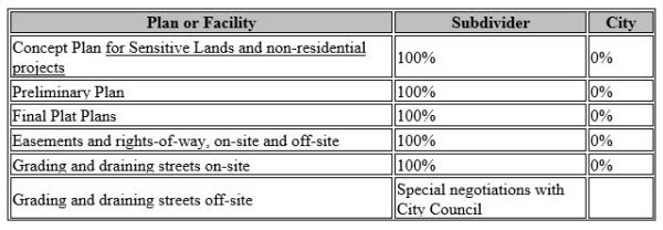
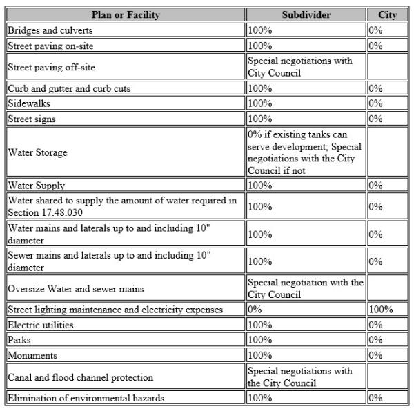
18.117.038 Costs And Charges
A. Required improvements and processing costs and charges. See the Adopted Heber City Fee schedule for costs. Charges in connection with the planning, processing, and development of subdivisions in the City shall be shared between the subdivider and the City according to the following schedule. Where infrastructure installation requires significant system-wide oversized improvements beyond those necessitated by the development, reimbursement agreements shall be considered as per State Law.
18.117.040 Amendments
Before approving a preliminary plat for development greater than 10 lots of a subdivision, the Planning Commission may require amendments or modification of the plan if it finds that: A. The layout of the subdivision does not conform to the required standards of design as set forth in this title and in the adopted Heber City Standard Specifications and Drawings;
B. The subdivision is not provided with adequate ingress or egress;
C. The subdivision design contains sensitive lands such as geologic, soil, water, or other hazards which could be detrimental to the subdivision, surrounding area, or to the City, and which are not adequately addressed in the application;
D. The subdivision does not provide the required improvements or quality of improvements or does not comply with other requirements as set forth in this chapter and in the adopted Heber City Standard Specifications and Drawings. Such amendments or modifications shall be sufficient in all cases to correct the inadequacies so that the subdivision will conform to the requirements of this chapter and the adopted Heber City Standard Specifications and Drawings.
18.117.042 Substantial Completion Of Subdivisions
Building permits and approvals for occupancy will only be issued pursuant to the provisions of Sections 15.04.040 and 15.04.050 and as required by the adopted Heber City Standard Specifications and Drawings.