
Heber City City Zoning Code
18.118 Trails
Design Standards
18.118.010 Purpose
As noted in the Heber City general plan, our goal is to develop and incorporate a public non-motorized trail system into the future and existing infrastructure of Heber City to provide safe transportation and recreation facilities, compatible with the rural and mountainous environments of Heber City. These trail standards have been implemented to accomplish the following:
A. Create a seamless and consistent trail network.
B. Improve the opportunity for alternative transportation.
C. Provide safe facilities for all users.
D. Enhance recreation opportunities for both residents and visitors.
E. Create design and construction standards for trails in Heber City.
F. Enhance recreation opportunities for both residents and visitors.
G. Create design and construction standards for trails in Heber City.
H. Provide enough trail options to keep traffic on trails at acceptable levels.
18.118.015 Standards
A. In the event of a conflict between this Chapter and other adopted trails standards, the most restrictive shall apply.
B. The standards of this Chapter may be modified by the City Engineer when trails are proposed to pass through developed subdivisions, established neighborhoods or lots containing existing buildings. In such instances, when it is legal to establish such trails in developed subdivisions, established neighborhoods or lots containing existing buildings, all reasonable efforts shall be made to establish trails, walkways, paths connecting trail systems, or trail connections, with existing sidewalks as connectors between standard trail sections, and, to locate or orient such trails, or connectors to trails on and along the outside property boundaries, at the farthest distance from homes and yards of private property, and to minimize infringement and encroachment upon existing homes, property lines and private property.
18.118.020 Trail Design
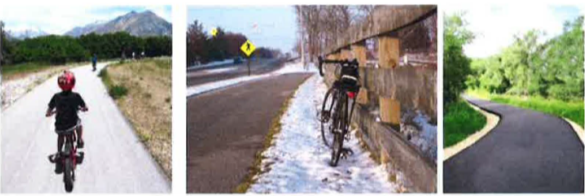
A. Trail Function. Anticipated trail use will essentially determine what type of trail to construct and where it will be built. There are two (2) general categories of trails: transportation and recreation, yet it is perfectly acceptable and common for the uses to be concurrent. Transportation trails are generally built as destination trails and primarily connect neighborhoods with one another or with public facilities, which may include schools, recreation centers, parks, town or resort centers, shopping areas, libraries, etc. The purpose is to allow a non-motorized user a corridor that limits interference with motor vehicle traffic and promotes non-motorized alternatives for short local trips. User types may include cyclists, disabled users, walkers and a variety of other youth type activities. Trails for recreation typically provide a connection to natural spaces and provide a range of challenges and features for the trail user. Loop trails are the preferred design that will allow users to begin and end at the same trailhead location. These trails typically connect to open spaces, national forests, state parks and neighborhood parks. User groups may include mountain and road cyclists, trail runners, equestrians, joggers, hikers and walkers. Trail surfaces are generally soft surface or natural surfaces.
B. Trail Users. These standards are set for non-motorized use and focused on all age groups, all levels of ability and generally include the following activity types: walkers, runners, joggers, hikers, cyclists (both mountain and road), skateboarders, disabled users, wheelchairs, equestrians, skiers, in-line skaters and baby movers ( carriages, strollers, joggers, etc.). While it is clearly not practical for all types of trails in a mountainous environment to be fully accessible to the disabled, where reasonably appropriate, trails should comply with the requirements of the Americans with disabilities act of 1990 (ADA).
C. Americans With Disabilities Act. A trail is considered ADA accessible if it meets the following criteria:
1. Five foot (5') minimum width. 2. Hard surfaces. Asphalt and concrete are the most accessible. Compacted crushed stone with a diameter less than three-eighths inch (3/s") is also acceptable. 3. Trail grade less than five percent (5%). 4. Ramps, not stairs, should be provided for grades exceeding the five percent (5%) maximum. 5. Ramp grades should not exceed eight percent (8%) and have a level landing for every thirty inches (30") of vertical rise and have a slip resistant surface. 6. Thirty two inch (32") high handrails should be installed on all ramps and bridges. 7. Trails should have a rest area every three hundred feet (300'), preferably cleared with a bench. 8. One or more accessible parking spaces should be provided at trail parking lots. 9. If gate or bollards are used to prevent motorized vehicle access to the trail, thirty two inch (32") clearance is necessary for wheelchair access.
D. Trail Location. The following are guidelines for how trails should be routed to reduce maintenance needs and environmental impacts while maximizing the trail experience:
1. General Guidelines:
a. Trails should be located and constructed in such a manner as to minimize maintenance and maximize access. Alignment should utilize the natural topography of the land and should follow natural contours where possible with respect to surrounding landforms.
b. Design features should preserve and promote natural elements, including geologic, scenic, wildlife and historic.
c. Construction must factor in erosion related to use and weather.
d. Trail design should consider the trail users experience. Alignments should avoid excessive switchbacks or lengthy steep grades. When creating alignments, consider intended volume, ability and type of user.
e. Locate trails for both summer and winter activities giving consideration to terrain and climate. Identify snow retention areas for possible cross country ski trails. In open areas, use trail alignments that take advantage of wind protection and shaded canyon areas.
f. Because each trail site is unique, specific trail proposals through sensitive areas need to be considered on a case by case basis.
g. Trails should be clearly separated from vehicle traffic. Users are generally safer and travel experiences are enhanced on separated trails. Snow removal and general maintenance are less costly when trails are separated from roads and parking lots. At-grade crossings at roads should be limited.
h. The trail grade should not exceed half the grade of the hillside the trail is traversing. This is primarily to limit erosion and is a general guideline. For example, if you build across a hillside with a side slope of twenty percent (20% ), the trail grade should not exceed ten percent (10%).
2. Standards For Grades, Vertical Clearance And Curve Radii:
a. Grades. Grades of five percent (5%) and below are acceptable for standard trail sections. Grades above five percent (5%) cannot be considered wheelchair accessible. Intersections should not exceed three percent (3%). Avoid sharp curves on grades exceeding five percent (5%) to avoid confrontations between different levels of users. The following table identifies lengths of trail for grades above five percent (5%) (backcountry or natural surface trails may exceed these grades for short distances, but must factor in appropriate erosion control measures):
| Grade (Percent) | Limit On Length At That Grade |
| <5 | None |
| 5-6 | 800 feet |
| 6-7 | 400 feet |
| 7-8 | 200 feet |
| 8-9 | 100 feet |
| 9-10 | 50 feet |
| >10 | 0 feet |
b. Line of Sight. Trail users need adequate sight line distances to anticipate changes in the trail and trail users coming from the opposite direction. An optimal clear view distance for bicyclists (the trail user traveling at the highest speed) is one hundred fifty feet (1501). If this distance cannot be met, appropriate signing must be placed to warn the user of curve ahead.
c. Vertical Clearance. Vertical clearance (or ceiling) is a ten foot (101) minimum. This allows for all types of non-motorized users. If pathways will be prepared for use during winter months, clearances should anticipate snow loading and be increased to sixteen feet (161).
d. Curve Radii. Curve radii will vary between allowed uses on multiple user trails. Bicycle standards should be followed, as this is the fastest moving user group requiring longer sight distances. Refer to the "AASHTO Guide for Development of Bicycle Facilities" for stopping distances, curve radii and intersection coordination.
3. Trail Types:
a. Improved Multi-Use Trail. Multi-use trails are major community arterial routes that are non-motorized, independent of vehicular routes and provide adequate separation from vehicles. They may bisect parks and open space, as well as parallel natural features, such as rivers and streams. These trails are both transportation and recreation oriented and should provide connections to cities, towns, back county trails and trailheads, parks, points of interest, and other transportation nodes. Where possible these trails should comply with AASHTO standards.
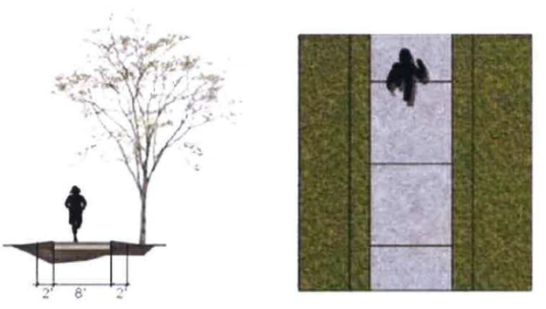
b. Improved Pedestrian Trail. Improved pedestrian trails are collector trails (including sidewalks) that are non-motorized and connect users to community trails. They may bisect neighborhoods, open space, commercial developments, parks, schools, etc., and parallel rivers and streams. Many existing pedestrian trails were designed and constructed prior to the regional trails master plan. Where possible, trials less than 8 feet wide should be widened and brought into current standards to improve access to more users.
Future construction of major sidewalks that connect to the core trail network should be adapted to meet the standards of improved pedestrian trails, which will include an 8 foot wide tread surface. Efforts should be made to maintain a consistent width and for residential sidewalks to remain between 4 to 8 feet.
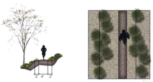
c. Backcountry Trail. Backcountry trails (single-track type) are defined as trails that provide access for users to explore areas outside of the urban trial network. These non-motorized trails are typically designed and constructed for a variety of recreational users, such as hikers, trail runners, mountain bikers, and equestrians.
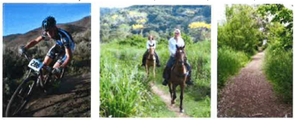
Because they are located outside of the urban network, the surface typically consists of natural dirt, creating an undeveloped feel for users. In some rare cases, other materials, such as gravel, may be implemented to aid in erosion control or stabilization. Backcountry trails are to be cut at a width of 4 feet.
In some cases, bridges, and boardwalks may be necessary to traverse though or over natural features in the backcountry. These structures should be designed and constructed to be compatible with all backcountry uses.
18.118.030 Construction Standards
A. Trail Surfacing. Heber City surfacing guidelines are provided for Improved Multi-Use Trails, Improved Pedestrian Trails and Back-country Trails.
Table 1: Trail Construction Standards Summary
| Trail Type | Sizing | Materials |
| Improvead Multi-Use | 10 ft. trail within a 20 ft. easement (can be up to 14 ft. for regional connections as determined by staff and trails map) | Asphalt - weed barrier, 3" of asphalt on top of 6" road base
Concrete and pavers can be used in appropriate areas such as intersections or plazas |
| Improved Pedestrian | 8 ft. trail within a 20 ft. easement | Concrete - weed barrier, 4" thick concrete pavement on top of a 6" depth of 3/4" gravel
Or Asphalt with weed barrier, 3" of asphalt on top of 6" of road base |
| Back-country | 4 ft. trail within a 10 ft. easement | Natural Surface |
B. Improved Multi-use Trails. Improved multi-use trails are major community arterial routes within the urban network. Because improved multi-use trails are designed for large volumes of users with varying uses, the surface materials should be a durable pavement. Asphalt is the preferred pavement type due to cost, ease of maintenance, and surface smoothness. Typical pavement cross sections for an asphalt multi-use trail should consist of the following:
1. a properly graded and compacted sub-grade that has been stripped of all organics and,
2. lined with a structural weed barrier fabric;
3. a 6" depth of compacted road base material; and
4. a 3" depth of hot mix asphalt (HMA) pavement.
In some circumstances, concrete or concrete masonry unit (CMU) pavers may be used to create a unique look or feel. These surfaces should be avoided in most areas due to the uneven joints and score lines that cause undesirable riding experiences for cyclists.
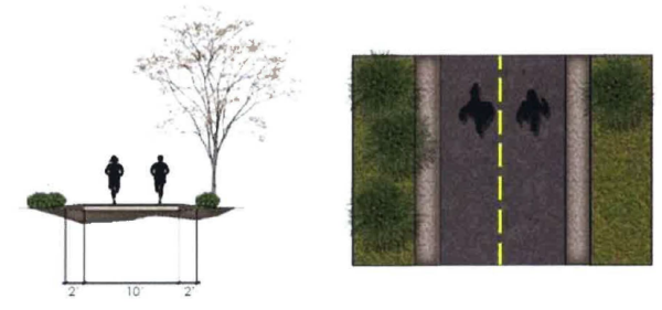
For improved multi-use trails in Heber City, a tread width between 10 and 13 is recommended. Trails with a 10-foot width should be actively pursued where cost and space permit. A lesser width may be required by the planning department where appropriate. 14 foot wide trails shall be used on trails identified on the trails plan as being a collector trail or a regional connection. By constructing wider trails initially, the county, cities, and other agencies will have made preparations for a growing population in the area. Wider trails will also accommodate larger trail specific competitions and events (see Figure 32). Maximum slope shall not exceed 5% except for short distances. All improved multi use trails should be constructed within a 20 foot easement.
C. Improved Pedestrian Trail. Improved pedestrian trails are more commonly referred to as sidewalks. The objective of the master plan is that future construction of major sidewalks will be adapted to meet the standards of improved pedestrian trials. The typical cross section of an improved pedestrian trail in Heber City should include an 8 foot wide tread surface. Trail construction should consist of a properly graded and compacted subgrade that has been stripped of all organics and lined with a structural weed barrier fabric followed by a 4" thick concrete pavement on top of a 6" depth of 3/4 " gravel or can be constructed with asphalt with a weed barrier, and a 3" layer of hot mix asphalt over 611 compacted road base.
Efforts should be made to update all existing improved pedestrian routes in the urban system to meet these standards. Residential and collector sidewalks can remain at 4 to 6 foot widths, but primary sidewalks should be constructed at 8 feet wide. All improved pedestrian trails should be constructed within a 20 foot easement.
D. Backcountry Trails. Backcountry trails, as classified in this document, are recreational trails outside of the urban network. Because they are located outside the urban network, tread material is often created from the natural sub-grade. In some cases other materials such as gravel may be implemented to aid in erosion control and/or stabilization. In all cases, these materials should be derived from adjacent areas to maintain a natural look and feel. Tread width of back country trails will vary based on vegetation, obstacles, and use. In most cases, backcountry trails should not exceed 48 inches wide within a 10 foot easement. Most backcountry trails will have a tread width of 12 to 24 inches, depending on use. The slope of backcountry trails is ideally less than 8%, with a maximum of 10% for runs of less than 100 ft. Back country trails should only exceed 10% in rare circumstances as approved by the county.
All backcountry trails should be designated with a rating to allow potential riders to make safe and informed decisions. The IMBA has developed a standard trail difficulty rating system applicable to mountain bike trails. By providing ratings on trial signs in accordance with IMBA's standards and by providing general trail characteristics such as total length, elevation change, and projected trip times at trailheads, all potential users can make educated decisions about the trails they use.
E. Backcountry trail construction standards
1. Backcountry trails should be built to IMBA standards. Surface treatment shall be a natural surface constructed with a bench width of 2 to 4 feet, which ensures environmental stewardship and allows for long-term sustainability by:
a. Incorporating bench-cut construction with a tread surface that has an outward slope to the outer edge from a grade of 2 to 8% in the downhill direction; and
b. Incorporating grade reversals and dips to reduce water erosion; these grades should average between 5 and 8%, with a maximum grade of no more than 10%, into the trail design and construction specifications.
Adding these features will help minimize tread erosion by allowing water to drain in a gentle, non-erosive manner and ensuring the soil stays on the trail where it belongs.
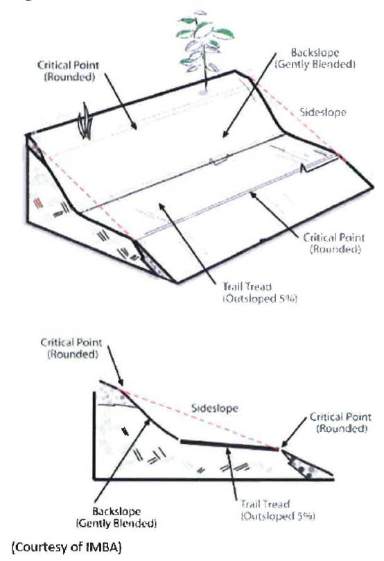
Figure 1: Trails Constructed Without Proper Cross Slope
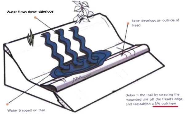
Figure 2: Proper Grade Reversal and Bench Cut Construction.
2. Surface And Width: The original trail cut should be four feet (4") wide. The tread surface will compact and revegetate leaving a two foot (2') wide usable tread surface. Terrain and levels of expected use should determine width. The trail surface (tread) must be free of all organic material. All vegetation debris should be dispersed downhill of the tread and be noticeable to users. Corridor should be clear of all branches and tree stumps within two feet (2') of the tread surface. Full bench construction is required (Figure 3).
Figure 3: Trail Cross Section
3. Grade: Grades should not exceed ten percent (10%). Optimal grades are between five (5) and eight percent (8%). If grades exceed ten percent (10%), which is only permitted on a limited basis, consideration must be given to the maintenance issues that may arise and the sustainability of the trail over time.
4. Drainage:
a. Outslope is two percent (2%) to five percent (5%). b. Rolling grade dips are the preferred water diversion feature (diagram 3). c. Knicks can also be used. These are sis (6) to ten (10) feet long and have a fifteen percent (15%) outslope (diagram 4). d. Swells can be used where drainage is possible. e. Drain dips cannot be constructed on grades exceeding ten percent (10%). f. Water bars can be used in rare circumstances where terrain is prohibitive to above. g. All topsoil removed to create the tread must be sidecast and dispersed.
Figure 4: Rolling Grade Dip
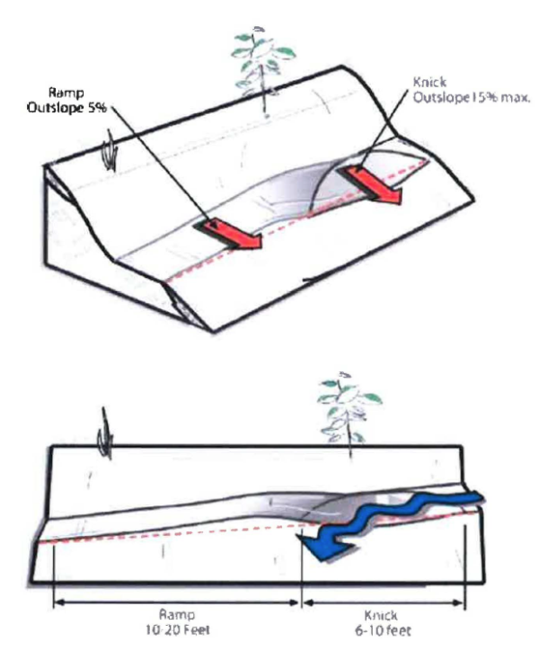
Rolling grade dips are a sustainable alternative to water bars. Dips are large enough to be self-cleaning and subtle enough that cyclist will not steer around them. A dip is longer than a bike and shaped like a knick. Use bondable soil from a dip to make a long, gentle ramp just past it. The ramp should be nearly twice as long as the dip.
Figure 5: Knick
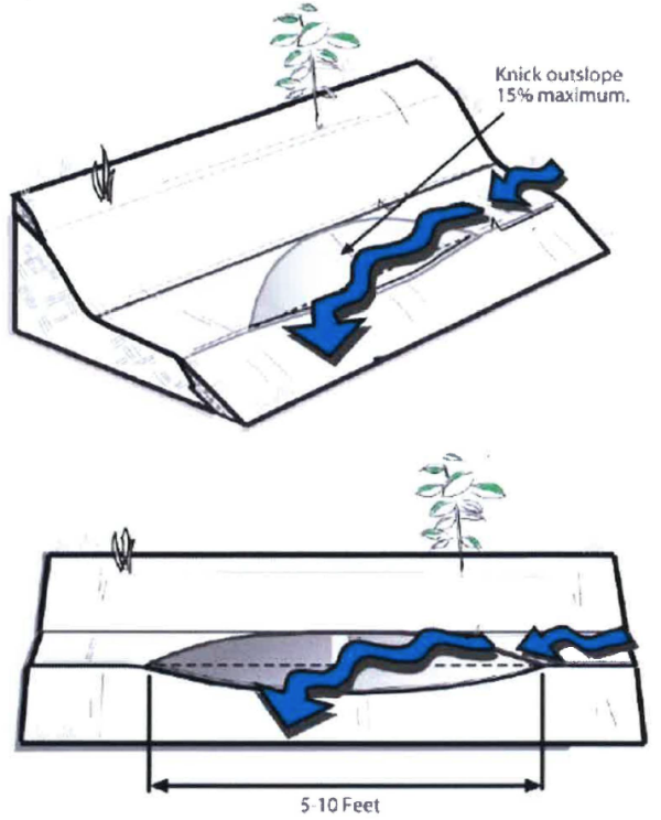
Knicks are used on gentle terrain to direct sheet flow off the trail. In contrast to rolling grade dips, soil from the knick is spread downslope off trail. The goal is sheet flow, not concentrated runoff. Knicks can be used on contour trails, to accentuate natural grade breaks and direct water off trails. Knicks should be long and subtle to be self-cleaning, yet unobtrusive to trail users.
5. Switchbacks and Climbing Turns
Figure 6: Rolling Crown Switchback
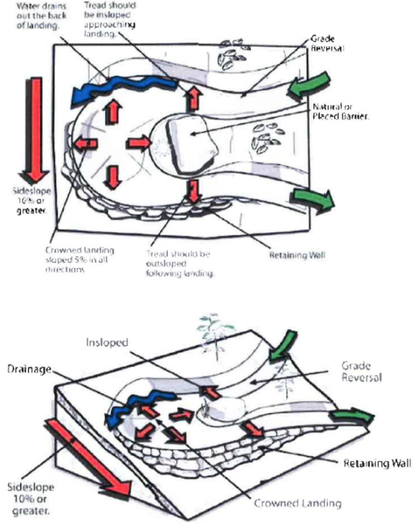
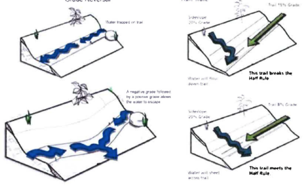
This shows the most sustainable type of turn of steep sideslopes. Inslope the trail bed only on the upper leg as it transitions to the crowned landing. The landing should have a 12 to 18 foot diameter, depending on trail width. The landing is outsloped in all directions. Build a grade reversal just before the upper leg to move water off the trail before it reaches the landing.
Figure 7: Climbing Turn
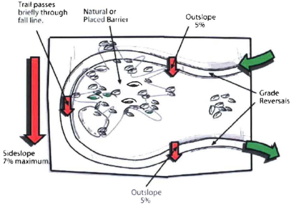
Maintain constant grade and radius through the tum section. Climbing turns may not be sustainable on sideslopes exceeding 7 percent grade.
Figure 8: Grade Reversal
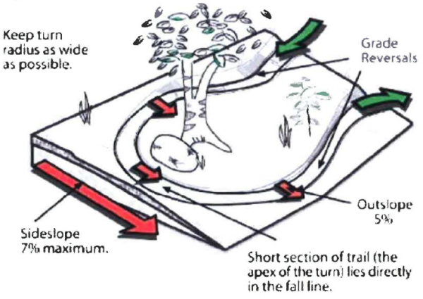
A climbing turn is any turn that ascends ( or descends) on the fall line of a sideslope. Improve sustainability by placing climbing turns on gentle slopes and using grade reversals to drain water above them. Climbing turns should have a large turning radius and barriers between legs to prevent shortcutting.
F. Trail Construction.
1. Guarantee for Trail Construction. Trail construction that is required as part of a development project will be subject to a security or bond that covers one hundred ten percent (110%) of the trail construction cost. This will be required at the same time the bonding is done for the other infrastructure requirements. All requirements and bonding will be completed with the Heber City Engineering Department. 2. Trail Easements. All public trails will require a recorded easement. All trail easements shall be noted and defined on a plat map or by recorded easement. Backcountry trails and some soft surface trails will be recorded as built, and will be included as an exhibit in the development agreement when receiving plat approvals from Heber City. Before bonds for the trails will be release the as-built trail easements must be recorded. 3. Phasing. When trails are part of a phased project, the phasing of various trail segments will follow a logical sequence for trail users. This phasing and expected dates of completion for trails shall be noted in the development agreement with Heber City. 4. Measures to Reduce Trail Construction Impacts. As stated previously, a good site selection for your trail will prevent most construction impacts. Water drainage and erosion must first be addressed during the trail location phase, allowing for the use of natural features to be incorporated into the trail design. The following may or may not be required for trail construction.
a. In ecologically sensitive areas, temporary fencing may be used to protect these features. b. Trails located near wetlands, may require boardwalk style construction. c. If using machinery to cut the trail, the right size equipment must be used. Different products are available specific to trail construction needs. d. If building near waterways or critical runoff points, trail layout will need to be reviewed on a case by case basis. Erosion matting or other device may be required for construction. e. In visually sensitive areas, work with hand tools may be necessary to reduce visual impacts. f. Indigenous materials should be used to the greatest extent possible for construction and revegetation practices. Seed mixes should be native; and care should be taken to not introduce nonnative materials into construction areas. g. Revegetation should occur quickly after construction dependent on the location, season and availability of water. Use of a native seed mix will be necessary. Trees and shrubs will need to be replaced if removed for construction purposes. For recommended seed mix and native vegetation please contact: Utah State University Extension Service, Heber City Branch, 55 South 500 East, Heber City, UT 84032.
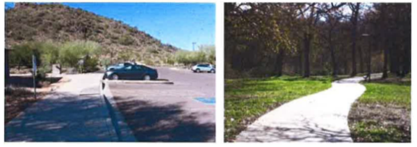
G. Trailheads. Trailheads generally provide four essential purposes: signing, off street parking, restroom facilities and trail access. Any access into the trail system is considered a trailhead. New development that includes public trails, must consider how the public will get to these facilities and how it will coordinate with other plans in the development. Trailheads should be visible, easily accessible and designed to accommodate the type of trail uses allowed. Equestrian trails will require more space than hiking or biking only trails for trailer parking and maneuvering.
1. Trailhead Classification. Access to a trail system is one of the primary elements for a successful trail network. Trailheads serve the local and regional population who access the trail network by car, transit, bicycle, foot, and/or other modes of travel. These access points provide essential connections to the system and serve as an information hub to educate and provide users with directions, maps, rules and regulations of the trails and area, closures, events, etc. Where appropriate, support facilities, such as resting areas, interpretive signs specific to the area, public art, restrooms, fountains, and bike racks, may be provided. To plan proposed trailheads and improve existing ones, the following classification standard was created. Three different classes are proposed based on capacity, location, trail access, and amenities.
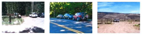
a. Class 1 Trailheads. Class 1 trailheads are classified as major developed parking hubs for both community and regional trails where heavy use is anticipated. Class 1 trailheads should include, but are not limited to, a minimum of 25 paved parking stalls, direct and safe trail access, restrooms, information kiosks, with maps and educational information, drinking fountains, bike racks, security lighting, public art, and monument signs, as determined at the time of approval, evaluation, and development. Class 1 trailheads should address good circulation patterns, site distances, proper drainage and storm water runoff, and landscaping, as required.
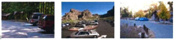
b. Class 2 Trailheads. Class 2 trailheads are classified as trail parking areas that include less than 25 parking stalls but more than six. Parking surfaces may be improved with road base, gravel, or pavement. Amenities may include, but are not limited to, restrooms, map kiosks, signs, safe and direct trail access, and other items, as determined at the time of approval, evaluation, and development. These trailheads should address good circulation patterns, site distances, and proper drainage and storm water runoff, if necessary.
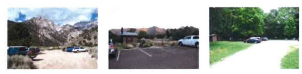
c. Class 3 Trailheads. Class 3 trailheads are classified as small, undeveloped, legal trail parking areas that provide six or less parking stalls and accommodates off-street parking. There are typically no trailhead amenities, such as restrooms, bike racks, etc. They do provide direct access to trails and often provide a map kiosk with trail information.
H. Bridges. Bridges can be a great attraction for trail users and most likely highlight a scenic vantage point. In Heber City, bridges may be used to span rivers, streams, canals, roadways, and steep topographic features. Two (2) design types can be used: custom made or a factory built steel truss. Both styles have advantages and disadvantages and some general recommendations have been made here. A custom bridge will use treated lumber that is resistant to decay for long-term durability. A typical custom bridge span is less than twenty (20) to twenty five feet (25). Longer spans for low bridges can be formed using piers, creating the aesthetically desirable possibility of aligning the bridge on a curve. Factory built bridges should be used for clear spans over twenty (20) to twenty five feet (25). These bridges can be ordered in any length and width, with several competing manufacturers. Decks can be wooden or concrete and all engineering is done by the manufacturer.
1. General Design Features.
a. Width of bridge should be the equivalent of the trail. This refers to the usable width of the bridge and does not consider construction requirements. b. Bridge alignments should allow for adequate sight distances and where possible be constructed to avoid the need for users to make sharp turns at either end of the bridge. c. Railings are required if the decking is farther than thirty inches (30) above the feature being spanned. Railings should be fifty four inches (54) high, with railings spaced not greater than fifteen inches (15) (if drop-offs are hazardous, this is limited to 4 inch spacing). d. All exposed bolt and screw heads should be countersunk to be flush with the wood surface. e. Breakaway design features must be used if the bridge is constructed in an area prone to flooding. f. The design must be structurally sound and approved by a licensed engineer. Design must factor in both live and dead load. g. Design and materials should fit in with surrounding development. h. Contact with state of Utah Division of Water Rights, Army Corp of Engineers and Heber City Engineer may be necessary, depending on location.
I. Fencing. Fencing should be installed only where physical separation is necessary for safety and/or to preserve adjacent landowner privacy. Fences should not create a narrow corridor effect for long stretches along the trail. Where possible, fencing should be located only on one side of the trail at a time. Fences should be no closer than five feet (5') from the trail edge and must also be located within the trail easement. Where fences are necessary along both sides of a trail, the minimum width should be twenty feet (20') as is consistent with the required trail easement. Gates are required for trails that cross stock grazing areas. Said gates will be a self-closing lever latch type.
J. Signs. The signing standards include three (3) types: informational, regulatory and interpretive. All types should be straightforward and simple to read and understand.
1. Informational Signs at Trailheads. These signs are primarily located at trailheads or areas where the user may experience a change in the trail experience. These signs should be located in such a way as to not interfere with the trail surface but be accessible to the users. 2. Interpretive Signs. These signs benefit the users by explaining some feature available on the trail route. The features may include historical, biological, natural resources, or cultural facts about an area. Often these signs are educational and will serve to relay management goals of an area. These must be located in appropriate areas. 3. Regulatory Signs. The following are some of the signs likely to be needed, along with their identification number and size. Some unusual signs may have to be custom made. These examples are taken from the "Manual on Uniform Traffic Control Devices", December 2000 edition (MUTCD). The MUTCD should be referenced for complete signing standards. 4. Stop and Yield Warnings.
a. "Stop" signs are intended for use where bicyclists are required to stop. b. "Yield" signs shall be installed on shared use paths at points where bicyclists have an adequate view of conflicting traffic as they approach the sign and where bicyclists are required to yield to the right of way. The visibility of approaching traffic must be adequate to permit the bicyclist to stop or take other measures to avoid that traffic. c. "Stop Ahead" and "Yield Ahead" signs should be used where an intersection cannot be seen on approach. They may also be used to emphasize the right of way at busy or dangerous intersections. d. "Driveway Crossing" should be used where a driveway crossing cannot be seen on approach. This sign can also emphasize busy or potentially dangerous driveway crossings.
5. Unexpected or Hazardous Conditions Warnings. These should be used only when necessary to warn of unexpected or potentially hazardous conditions. The signs should be placed to least fifty feet (50') before the hazard.
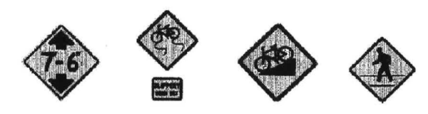
6. Turn and Curve Warnings. If the trail changes direction unexpectedly and the change is not readily apparent on approach, use appropriate tum or curve signs to warn bicyclists. They should normally be installed no less than fifty feet (50') in advance of the beginning of change of alignment.

Figure 2: Sign Sizes for Shared Use Paths
| Sign | MUTCD Code | Minimum Sign Size | |
| Millimeters | Inches | ||
| Stop | R1-1 | 450 x 450 | 18 x 18 |
| Yield | R1-2 | 600 x 600 x 600 | 24 x 24 x 24 |
| Bicycle lane | R3-16, 16a, 17, 17a | 600 x 750 | 24 x 30 |
| Movement Restriction | R4-1, 2, 3, 7 | 300 x 450 | 12 18 |
| Begin Right Turn Lane Yield to Bikes | R4-4 | 900 x 750 | 36 x 30 |
| No Motor Vehicles | R5-3 | 600 x 600 | 24 x 24 |
| Bicycle Prohibition | R5-6 | 600 x 600 | 24 x 24 |
| No Parking Bike Lane | R7-9, 9a | 300 x 450 | 12 x 18 |
| Pedestrians Prohibited | R9-3a | 450 x 450 | 18 x 18 |
| Bicycle regulatory | R9-5,6 | 300 x 450 | 12 x 18 |
| Shared Use Path Restriction | R9-7 | 300 x 450 | 12 x 18 |
| Railroad Crossbuck | R15-1 | 600 x 112 | 24 x 4.5 |
| Turn and Curve Warning | W1-1, 2, 3, 4, 5 | 450 x 450 | 18 x 18 |
| Arrow Warning | W1-6,7 | 600 x 300 | 24 x 12 |
| Intersection Warning | W2-1, 2, 3, 4, 5, | 450 x 450 | 18 x 18 |
| Stop, Yield, Signal Ahead | W3-1a, 2a, 3 | 450 x 450 | 18 x 18 |
| Road Narrows | W5-2a | 450 x 450 | 18 x 18 |
| Bikeway Narrows | W5-4 | 450 x 450 | 18 x 18 |
| Hill Sign | W7-5 | 450 x 450 | 18 x 18 |
| Bump or Dip | W8-1, 2 | 450 x 450 | 18 x 18 |
| Bicycle Surface Condition | W8-10 | 450 x 450 | 18 x 18 |
| Advance Grade Crossing | W10-1 | 450 Diameter | 18 diameter |
| Bicycle Crossing | W11-1 | 450 x 450 | 18 x 18 |
| Low Clearance | W12-2 | 450 x 450 | 18 x 18 |
| Share the Road Plaque | W16-1 | 600 x 750 | 24 x 30 |
| Supplemental Bike route Plaque | D1-1 | 600 x 150 | 24 x 6 |
| Bicycle Parking | D4-3 | 300 x 450 | 12 x 18 |
| Bike Route | D11-1 | 600 x 450 | 24 x 18 |
| Bicycle Route Marker | M1-8 | 300 x 450 | 12 x 18 |
| Bicycle Route Marker | M!-9 | 450 x 600 | 18 x 24 |
| Supplemental bicycle Route Guide | M4-11, 12, 13 | 300 x 100 | 14 x 4 |
| Route Marker Supplemental Plaques | M7-1, 2, 3, 4, 5, 6, 7 | 300 x 225 | 12 x 9 |
7. Sign Construction Features (Sample Bollards and Mile Markers).
a. Sign Posts: There are many design solutions to signage along a trail; below is one commonly used design. Post location will conform to the standards set forth in the MUTCD section on "Traffic Control Devices for Bicycle Facilities". Signposts will be four by four (4 x 4) pressure treated Douglas fir, embedded into the ground a minimum of twenty four inches (24") unless other materials are specifically approved. Attachment Systems: Signs should be attached to wood posts with three-eighths inch (3/8") diameter galvanized carriage bolts in a minimum of two (2) locations per post. b. Sign Bollards: These should be located at all trail access points. Posts should be constructed of Redwood or pressure treated Douglas fir. The individual symbols are three inches (3") square reflective decals that can be ordered from Carsonite International. They should be mounted on heavy gauge aluminum plate routed into the post a minimum of two inches (2") and epoxied into place.
K. Crossings and Roadway Interface. Heber City and the Heber Valley are dissected by US-189 and US-40, regional highways which connect the County to the Wasatch Front and the Uintah Basin. These highways carry a significant volume of semi-trucks, which makes crossing these roads a challenge. To improve trail connectivity between communities within the valley, three types of crossings, at-grade, elevated, or underpass, will need to be considered for each location (see Figure 3). Construction type will be based on the average daily trips (ADT) projected at build out.
1. At-Grade Crossings. Of the three crossing options, building an at-grade crossing may be the least expensive. Several multi-use trails in the urban area of the Wasatch Front cross major collectors that carry high volumes of traffic. These crossings may be a cost effective solution since they can be used at signalized intersections within downtown Heber City where speeds are lower.
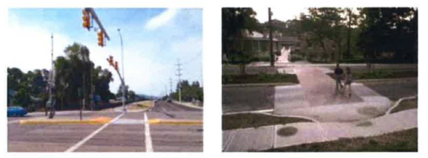
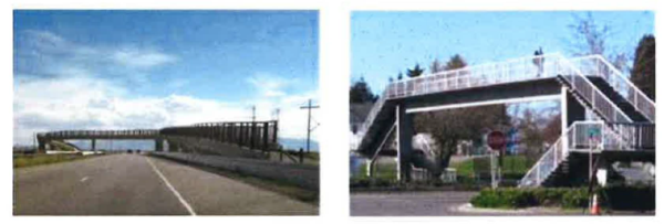
2. Trail Overpasses. When trails need to cross higher speed roadways, grade separation is required for safety. A trail bride over US-189 or on US-40 north or south of the Heber City limits would be recommended as it will allow for trail users to cross safely. Trail bridges can be expensive (typically exceeding $1 million) as additional property is needed to build the ramps and meet height requirements.
3. Trail Underpasses. Building a tunnel or underpass is another solution to safely separate trails from high volume/high speed roadways. Depending on the number of underground utilities, the level of groundwater in the area, and soil types, an underpass can be a cost effective solution for the proposed trail crossing on US-40 and US-189. These underpasses will require lighting for safety.
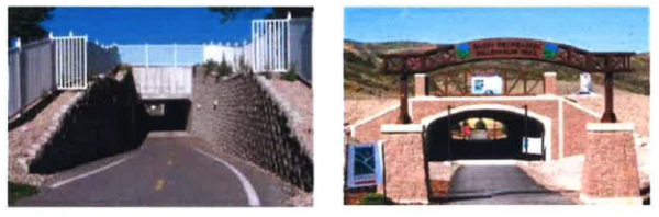
Figure 3: Pros and cons table for trail crossings
| Crossing Type | Pros | Cons |
| At-Grade Crossing | Low Cost Low Visual Impact No Grade Change | Traffic Disruption Pedestrian Safety |
| Pedestrian Overpass | Pedestrian Safety Potential Landmark Unique Feature | Cost Large Footprint High Visual Impact |
| Pedestrian Underpass | Small Footprint Low Visual Impact Safety | Cost Potential for Flooding |