
Minturn City Zoning Code
ARTICLE 10
Bolt's Lake, Willow Creek, Rock Creek and Holy Cross Character Areas2
Editor's note—Ord. 1-2024 §5.3, adopted Mar. 6, 2024, amended the title of Art. 10 to read as herein set out. The former Art. 10 title pertained to Bolt's Lake, Gilman, Willow Creek, Rock Creek and Holy Cross Character Areas.
Sec. 16-10-10.- Establishment of Bolt's Lake, Willow Creek, Rock Creek and Holy Cross Character Areas.
The Zoning Map of the Town is hereby amended to reflect the establishment of the Bolt's Lake, Willow Creek, Rock Creek and Holy Cross Character Areas as shown on Attachment A, a copy of which is available at the Planning Department.
(Ord. 12-2008 §2; Ord. 15-2008 §1; Ord. 1-2024 §5.4)
Editor's note— Ord. 1-2024 §5.3, adopted Mar. 6, 2024, amended the title of Art. 10 to read as herein set out. The former Art. 10 title pertained to Bolt's Lake, Gilman, Willow Creek, Rock Creek and Holy Cross Character Areas.
Sec. 16-10-20. - Character Area characteristics.
Except as otherwise provided in Section 16-10-30, uses within the Bolt's Lake, Willow Creek, Rock Creek and Holy Cross Character Areas shall be set forth on an approved final development plan for those areas. Until such time as a final development plan is approved, property within the Bolt's Lake, Willow Creek, Rock Creek and Holy Cross Character Areas shall be used only for the following purposes:
(1)
Environmental response activities for superfund sites consistent with EPA and CDPHE process and approvals and this Article.
(2)
Forestry management and maintenance, including without limitation measures to address the infestation of pine beetles and abatement of noxious weeds.
(3)
Passive recreation activities consistent with historic practice.
(4)
Management and maintenance of the property as open space, greenbelt and wildlife habitat.
(5)
Investigation and monitoring of soils, watersheds and other components of the property and other appropriate activities in connection with the management and maintenance of the property and the preparation of the application for the final development plan for the project.
(6)
Operation, maintenance and use of water rights, water resources, water diversion structures, ditches, pipeline structures, ponds, water impoundments and associated facilities consistent with the decreed uses but subject to these restrictions.
(7)
Hunting.
(Ord. 12-2008 §2; Ord. 1-2017 §§3, 5.2; Ord. 1-2024 §5.5)
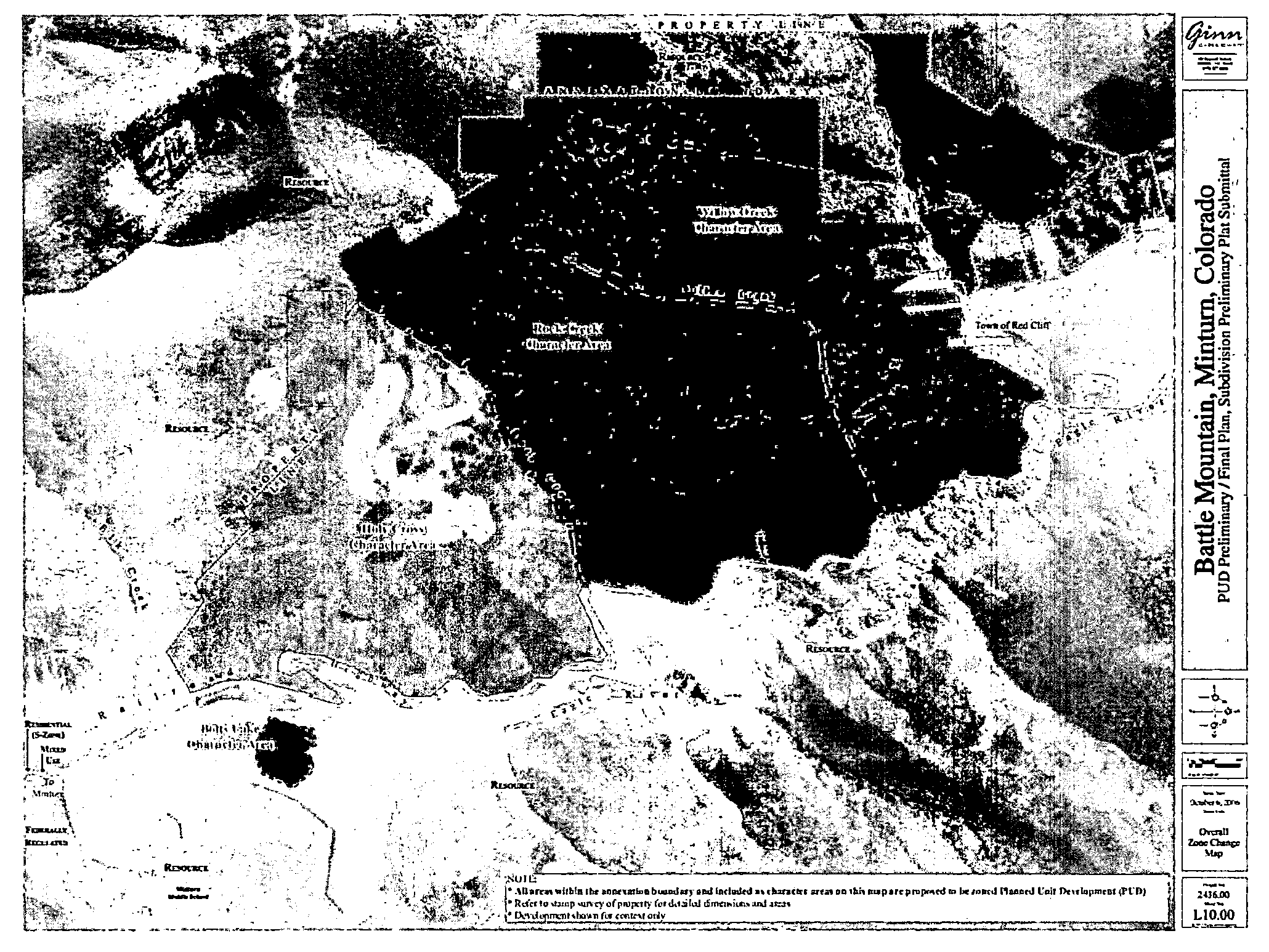
Sec. 16-10-25. - Willow Creek, Rock Creek and Holy Cross Character Areas map.
The Willow Creek, Rock Creek and Holy Cross Character Areas map is set forth in Illustration 16-10.5 below:
Illustration 16-10.5
Willow Creek, Rock Creek and Holy Cross Character Areas Map
(Ord. 1-2017 §§3, 5.3; Ord. 1-2024 §5.6)
Sec. 16-10-30. - Permitted uses of ranch lots and estate lots.
Notwithstanding anything in Section 16-10-20 to the contrary, Table 16-5.5 sets forth the uses for any ranch lot or estate lot located within the mountaintop area. Permitted uses must be located within designated buildable areas unless otherwise indicated:
TABLE 16-5.5
(Ord. 1-2017 §§3, 5.4)
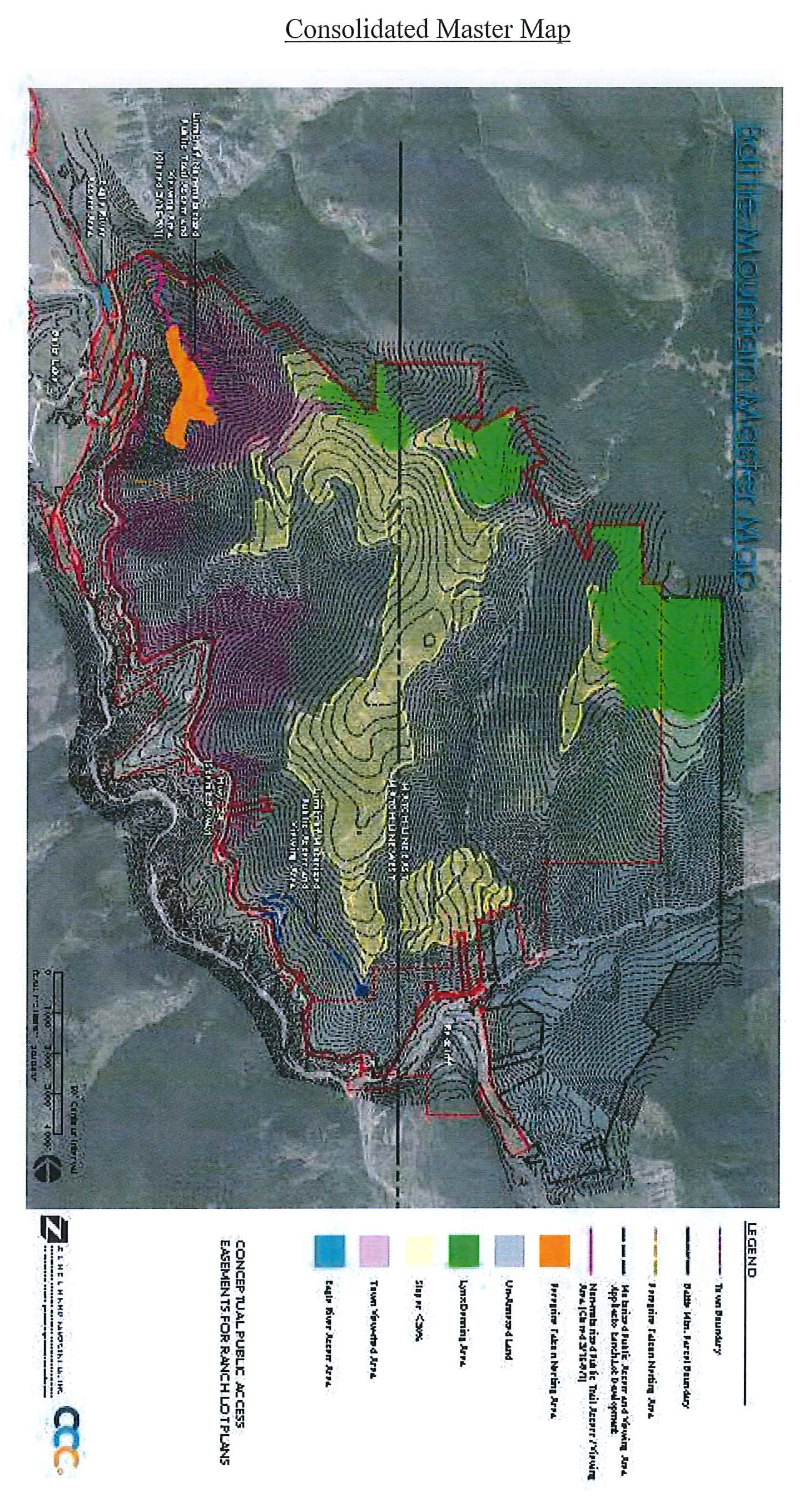
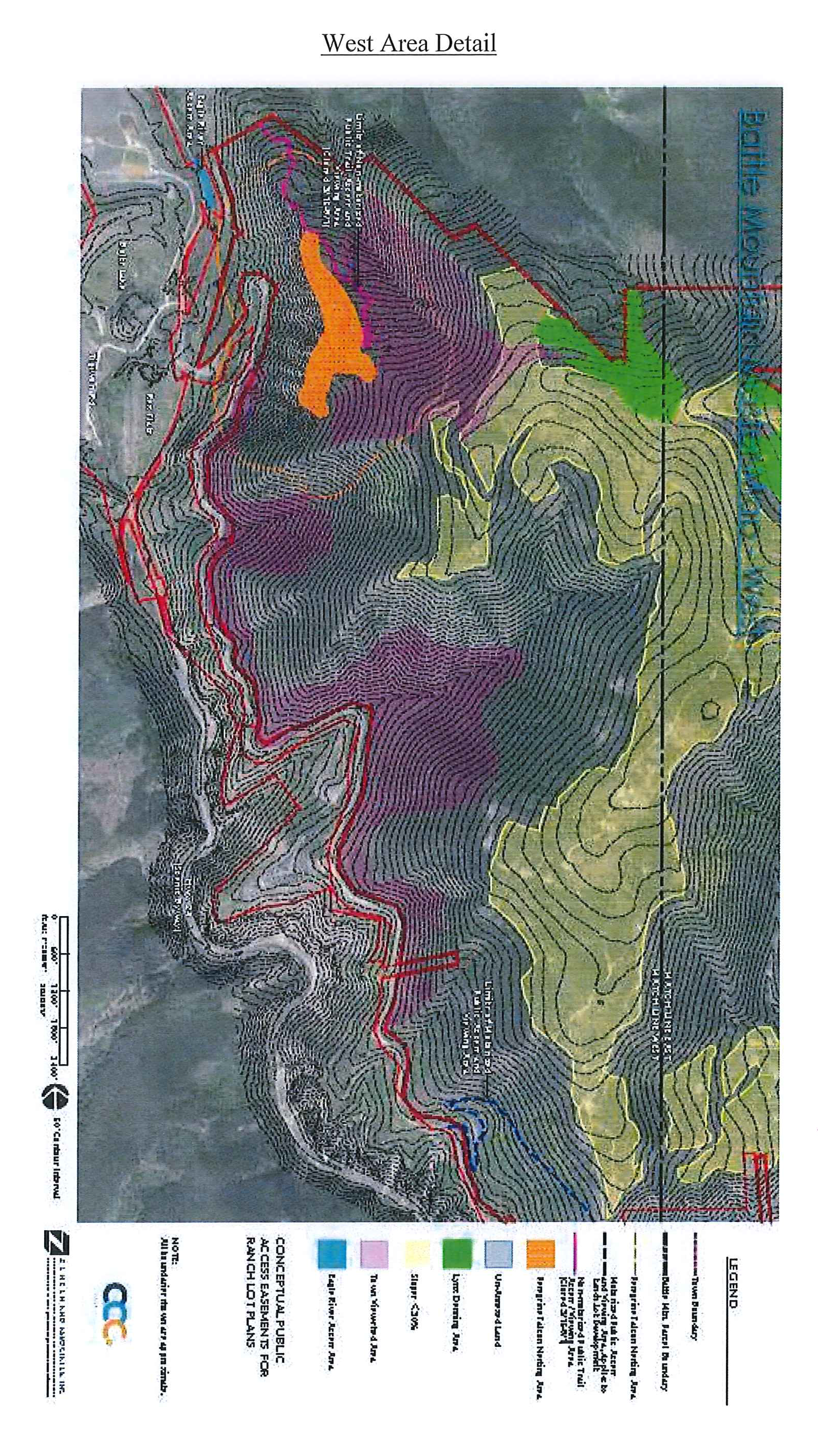
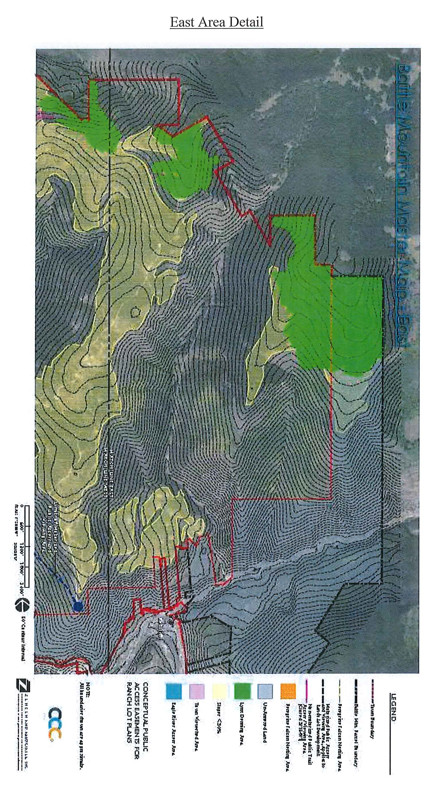
Sec. 16-10-35. - Master map for mountaintop area.
The master map, as defined in Section 16-2-20, is set forth as Illustration 16-10.6 below.
Illustration 16-10.6
Mountaintop Area Master Map
(Ord. 1-2017 §§3, 5.5)
Sec. 16-10-40. - Terms and conditions applicable to ranch lots and estate lots.
Notwithstanding anything in Section 16-10-20 to the contrary, permitted uses pursuant to Section 16-10-30 within ranch lots and estate lots located within the mountaintop area must be developed and maintained in accordance with the following terms and conditions:
(1)
Notwithstanding anything to the contrary in Article 15 of Chapter 16, or in Section 16-10-20, development within ranch lots and estate lots is exempted from the requirement of submittal, review and approval of a concept plan, a preliminary development plan, a final development plan, a PUD agreement, a general development plan or a site plan.
(2)
Provision of potable water and sanitary sewer for development within ranch lots and estate lots will comply with the requirements set forth in Article 7 of Chapter 13.
(3)
Except as expressly set forth in this Section 16-10-40, no additional requirements will apply as to setbacks, minimum front yard, minimum rear yard, minimum side yard dimensions, building lot coverage and impervious coverage.
(4)
Construction of buildings, structures and related improvements within ranch lots and estate lots will comply with the requirements set forth in Article 15 of Chapter 18 and the following:
a.
Development within any ranch lot or within any estate lot will not be subject to the design standards or to design review pursuant to Sections 16-17-200 and 16-21-615, and Appendix B to this Code, provided that such ranch lots or estate lots will be subject to a recorded private design review covenant and review for compliance therewith by a private design review board created pursuant to the private design review covenant. The design review covenant will contain a separate section that requires compliance with this Section 16-10-40(4). Prior to recording such private design review covenant, or any subsequent amendments thereto, the Planning and Zoning Commission will be provided a copy for review and approval; provided that the scope of such approval right will be limited to confirming that the design review covenants contain the provisions required under this Section 16-10-40(4). The Town shall be an express intended third party beneficiary with the power of enforcement of those portions of the design review covenants required under this Section 16-10-40(4).
b.
All buildings that house a single family dwelling, accessory dwelling or caretaker unit must be situated within the designated buildable areas(s) designated on the applicable ranch lot plat or estate lot plat.
c.
Areas located outside of designated buildable areas will be maintained as active or passive open space; provided, however, that the uses permitted pursuant to Section 16-10-30 (but not dwellings, accessory buildings or structures, unless approved as a conditional, limited or temporary use), may be located outside of designated buildable areas.
d.
Minimum front setback of one hundred (100) feet from the property line from which vehicular access is provided to and from a street.
e.
Maximum building height of forty-five (45) feet. Section 16-2-60 will not apply.
f.
No bulk plane requirements will apply.
g.
Unless approved as a limited use or conditional use, the following physical parameters shall apply to all development on ranch lots and estate lots:
h.
Development within ranch lots and estate lots is exempted from Section 16-2-50, except clauses (b), (c) and (d) thereof pertaining to setbacks from rivers and creeks.
i.
Development within ranch lots and estate lots is exempted from Section 16-17-110 regarding underground utilities.
j.
Development within ranch lots and estate lots is exempted from Sections 16-17-140, 16-17-150, 16-17-160, and 16-17-170 regarding landscaping standards, provided that landscaping standards will be incorporated in the private design review covenant referenced in subparagraph a.
k.
Development within ranch lots and estate lots is exempted from Chapter 16, Article 20 of the Zoning Code regarding environmental impact reports.
l.
Fencing on ranch lots and estate lots must be located exclusively within designated buildable areas unless the owner receives a limited review approval allowing fencing to be located outside of a designated buildable area.
m.
The private design review covenant referenced in subparagraph A above will incorporate a provision that addresses mitigation of impacts to wildlife, as such matters are reasonably pertinent to the mountaintop area, in a manner that is generally consistent with Sections 5.2, 5.5.1 through 5.5.4, 6.1, 6.2, 7.0, and 11.0 of the February 28, 2008 Ginn Resorts Wildlife Mitigation and Enhancement Plan.
(5)
Limited uses identified in Section 16-10-30 will be processed and reviewed in accordance with Section 16-21-630. Approval of a limited use shall be based upon the following criteria:
a.
The Planning Director shall approve the limited use based upon the submittal and review of the material identified below, and shall approve the use and/or structure upon finding that the limited use (i) is not in conflict with applicable health, sanitation, safety or access regulations; and (ii) can be operated so that it is compatible with adjacent uses and negative impact to adjacent properties has been reasonably minimized.
b.
The use and/or structure otherwise complies with applicable requirements stated in subparagraph (4) of this Section 16-10-40.
(6)
Conditional uses identified in Section 16-10-30 will be processed and reviewed in accordance with the provisions of Section 16-21-620. In addition to the application materials listed in Section 16-21-620, the application for any conditional use that will not be served from a community water system shall include a water supply plan describing water quality, quantity, dependability, and legal availability prepared by a licensed professional engineer or hydrologist containing the following information:
a.
The average daily demand of the proposed conditional use and the capacity to accommodate peak demands to service the conditional use.
b.
The demand for irrigation water for landscaping and agriculture shall be based upon the type of vegetation to be maintained, soil characteristics, the historic yield of the property.
c.
The water supply demand for fire protection shall be based upon recognized and customary engineering standards and requirements of the applicable fire protection district.
d.
The following technical information: (I) a minimum four-hour pump test shall be performed on the well(s) to be used; (II) the results of the pump test shall be analyzed and summarized in a report that (a) contains basic well data (size, depth, static water level, aquifer, etc.) pumping rate, draw down, recharge, and estimated long-term yield, (b) includes an opinion that the well will be adequate to supply water for the proposed uses, and (c) addresses impacts to ground water resources in the area; (III) if a well is to be shared, an applicant shall submit a proposed form of legal well-sharing declaration addressing all easements and costs associated with operation and maintenance of the system and identifying the person responsible for paying costs and how assessment will be made for those costs; (IV) water quality shall be tested by an independent testing laboratory for (a) alkalinity, arsenic, cadmium, calcium, coliform bacteria, chloride, conductivity, copper, corrosivity, fluoride, hardness, iron, lead, magnesium, manganese, nitrate/nitrite, pH, sodium, sodium adsorption ratio, sulfate, total dissolved solids, uranium, zinc and alpha/beta radioactivity; (b) such additional testing as the Town may reasonably request for other contaminants that occur within the Minturn area; and (c) the test results shall show that the Maximum Contaminants Levels (MCLs), as set forth by CDPHE within the Colorado Primary Drinking Water Standards, are not exceeded, or the applicant has otherwise identified a treatment system that will bring the water within acceptable MCLs; and (V) annual testing, testing for other contaminants, and testing for secondary drinking standards including taste, odor, color, staining, scaling, and corrosion is also recommended.
e.
If served by a private well other than a thirty-five (35) acre exempt well, a description of the water rights to be used to serve the conditional use and an opinion that such water rights are adequate to meet both the average and peak demands of the conditional use without causing injury to senior water rights within the Eagle River and Colorado River basins.
(Ord. 1-2017 §§3, 5.6)