
Morehead City City Zoning Code
ARTICLE 15
- LANDSCAPING, RECREATION, AND OPEN SPACE
15-1 - Purpose
15-1.1
To encourage high quality design in development, structures, and the use of land through proper siting of structures and uses;
15-1.2
To provide flexibility in achieving the desired standards of development;
15-1.3
To protect and enhance the natural environment;
15-1.4
To establish landscaping standards for property proposed for development;
15-1.5
To establish requirements for open space, recreation, and water access areas in new subdivisions;
15-1.6
To enhance the appearance of the City;
15-1.7
To protect public and private investment;
15-1.8
To mitigate adverse impacts on adjacent property when the use or development of the adjacent property is significantly different in character, density, or intensity by maintaining a provision for screening between certain districts and/or uses;
15-1.9
To reduce adverse impacts of development such as dirt, litter, traffic, noise, odor, glare of lights, etc.; and
15-1.10
To encourage the preservation of existing trees, when feasible.
(Ord. No. 2025-O-04, 1-14-2025)
15-2 - Applicability
15-2.1
Landscaping and screening requirements are applicable in accordance with Section 15-5 and in the following situations:
(A)
New development/construction. Landscaping and screening requirements shall be provided for the entire property under development.
(B)
Expansion of on-site building area.
(1)
When on-site building area is increased by less than fifty (50) percent, the landscaping and screening requirements of Section 15-5 shall be provided to meet the requirements within the project area.
(2)
When on-site building area is increased by fifty (50) percent or more, the landscaping and screening requirements of Section 15-5 shall be provided for the entire site as if it were a new development.
(3)
Where existing parking areas, existing buildings, or driveways prevent the development of a full screen, screening shall be provided to the maximum extent possible.
(C)
Expansion of a parking facility. If a parking area is expanded, the area undergoing expansion must comply with the current landscaping requirements.
(D)
Reconfiguration/restriping of existing parking area. If a parking area is expanded, the area undergoing expansion must comply with the current landscaping requirements.
(E)
Screens apply only when a property under development shares a common boundary line with a different zoning classification as determined in Table 15-5.1.
(F)
In the event that screening and landscaping requirements apply along the same property line, the minimum screening requirements shall be applicable along the area in which the requirements overlap.
15-2.2
Recreation and open space areas are required for subdivisions in accordance with Section 15-7.
15-2.3
Water access areas are required for subdivisions in accordance with Section 15-8.
15-2.4
Applicability to City and other Governmental Entities. The landscaping and screening provisions of this Article shall apply to the City and to any other governmental entities owning property within Morehead City planning areas.
15-2.5
Residential Lot Exemption. Individual single-family and two-family (duplex) residential lots are exempt from the provisions of this Article.
15-2.6
Installation or Security Required. The landscaping and screening required under this Article shall be installed or the installation shall be guaranteed by a bond, letter of credit, cash, or other security approved by the Land Use Administrator prior to issuance of a certificate of occupancy.
(Ord. No. 2025-O-04, 1-14-2025)
15-3 - General Landscaping and Screening Requirements
15-3.1
Locational Requirements:
(A)
No landscaping or screening shall be located in such a manner which interferes with the sight distance required at any roadway or driveway intersection.
(B)
The landscaping and planting requirements of this section shall not be construed to allow plantings or growth to extend into a sight triangle to a degree that would hinder safety.
(C)
Landscaping or screening located within a sight triangle shall be limited to a maximum height of three (3) feet.
(D)
No plantings, landscaping, or screening required under this Article shall be located within any portion of an existing or dedicated public or private street, alley, right-of-way, or utility easement.
(E)
Plantings should be established and maintained in such a manner as to minimize the potential for interference with utility lines and other utility infrastructure.
(F)
Required screens and landscape strips may be included within or combined with the required minimum setback yards as established in Section 13-1.1 of this Ordinance.
15-3.2
Landscape Area Specifications:
(A)
All landscape areas shall be seeded or planted with grass or ground cover unless ground cover is already established.
(B)
Plantings shall generally be spaced equidistant throughout screen and landscape areas in such a way to facilitate the creation of a visual screen.
(C)
Minimum planting sizes shall be in accordance with Table 15-3.1.
(D)
Existing plant materials that meet the requirements of this section may be counted toward the plant materials requirements.
Table 15-3.1 Minimum Planting Sizes
15-3.3
Planting Type Specifications:
(A)
Recommended understory and canopy trees are provided under Appendix VI.
(B)
Substitution of plant species from those listed in Appendix VI may be approved provided that:
(1)
The planting type is approved by the Land Use Administrator and that the substitution is noted on the approved landscape plan;
(2)
The plantings are selected based upon species that are highly adapted to the climate of the City and to the soils, drainage patterns, wind, and other conditions of the particular site;
(3)
The information provided demonstrates that the plant to be substituted is of like-kind with the required plant type (i.e. canopy tree, understory tree, shrub); and
(4)
The minimum planting size requirements of Table 15-3.1 are met at the time of planting.
15-3.4
Prohibited Use of Required Landscaping and Screening Areas:
(A)
Landscaping and screening areas shall not contain the following uses:
(1)
Useable or active recreation areas;
(2)
Parking;
(3)
Storage containers;
(4)
Signage, merchandise, and/or displays associated with itinerant merchant operations;
(5)
Accessory buildings and uses except as allowed under Subsection 15-2.1(B)(3);
(6)
Any other use unless excepted in Subsection 15-3.4(B) below.
(B)
Exceptions from Subsection 15-3.4(A) above include uses specifically required by or permitted under this Ordinance or as needed for underground utilities, stormwater retention areas, or pedestrian or vehicular access to adjoining property or to street rights-of-way or alleys.
15-3.5
Certain uses have additional landscaping requirements which are contained under Article 14.
15-3.6
Maintenance Requirements:
(A)
If a landscaping plan is approved by the City, periodic inspections may be conducted by the City staff in order to determine the continued effectiveness of required landscaping and screening.
(B)
Approved landscaping and screening shall be maintained by the property owner in perpetuity to continue its effectiveness unless a revised landscaping plan is approved in accordance with the requirements of Article 15 which allows for the revision of planting locations and specifications.
(C)
Replacement plants shall be the same type as those being replaced unless approval is granted by the Land Use Administrator to plant alternate species in accordance with this Article.
(D)
Failure to maintain or replace landscaping materials that have died, become diseased, or are damaged shall result in enforcement action in accordance with Article 7.
(Ord. No. 2025-O-04, 1-14-2025)
15-4 - Preservation of Existing Trees and Vegetation
15-4.1
Protecting Existing Trees:
(A)
Tree Preservation Credit in Lieu of Tree Installation: Tree preservation credits may be utilized to preserve existing trees in lieu of planting some or all of the required plantings on a site in accordance with the following requirements:
(1)
Required protection of credited trees:
(a)
Prior to any grading or construction on the property, a temporary fence shall be constructed around any tree which is to receive credit.
(b)
The fence shall extend from the trunk sixteen inches for each one (1) inch of trunk diameter.
(c)
No heavy equipment shall be used or stored within the area enclosed by the temporary fence.
(d)
No building materials or soil shall be stored within the area enclosed by the temporary fence except in accordance with Subsection 15-4.1(A)(1)(g).
(e)
Installation of underground utilities shall not be permitted within the area enclosed by the temporary fence.
(f)
Road and foundation grade cuts shall not be located within the area enclosed by the temporary fence.
(g)
Fill may be placed within the fenced area subject to the following:
1.
The material must consist of good topsoil, high in organic matter and of loamy texture;
2.
The fill must be of an appropriate depth for the tree type with an absolute maximum depth of six (6) inches.
3.
Fill placed within the fenced area must be placed by hand to ensure that there is no compaction of the soil.
4.
Soil shall not be placed immediately adjacent to the trunk.
(2)
Each tree preservation credit may be counted as either a required understory tree or shrub.
(3)
Plants credited under this section may be located outside of the landscape area for which credit is sought if it is determined by the Land Use Administrator that the overall landscaping on the site will provide adequate screening between significantly different uses.
(4)
Existing trees are eligible for tree preservation credits in accordance with Table 15-4.1.
Table 15-4.1 Tree Preservation Credits
15-4.2
Tree Removal:
(A)
Tree Removal in Rights-of-Way and Public Areas within the Corporate Limits: Refer to Section 20-11 of the Morehead City Code of Ordinances.
(B)
Tree Removal by Public Services Department: Nothing contained in this Article shall prohibit the Public Services Department from removing, pruning, or clearing trees and other vegetation from rights-of-way or easements.
(C)
Tree Removal by Public Utility Companies: Nothing contained in this Article shall prohibit public utility companies from removing, pruning, or clearing trees and other vegetation from rights-of-way and easements for purposes of maintaining service upon lands in which it has acquired an easement or right-of-way.
(D)
Tree Removal as a Forestry or Agricultural Activity: Removal of trees shall be permitted as a forestry or agricultural activity, provided the following requirements are met:
(1)
Applicable permits shall be obtained before trees are removed, including a zoning permit from the City's Planning and Inspections Department.
(2)
A minimum of fifteen (15) undisturbed natural buffer shall be maintained along all perimeter property lines, unless other buffers are required by this Ordinance.
(E)
Removal of Protected Trees on Private Property. All protected trees shall be preserved to the maximum extent possible, with the following exceptions:
(1)
A proposed development which encompasses a parcel(s) which is one (1) acre in size or less;
(2)
A proposed development which is dedicated as a school site, playing field, or non-wooded recreation area;
(3)
A subdivision or re-subdivision; and
(4)
Trees that are diseased or infested should be removed and replaced or treated to prevent the transmission of disease or infestation, to prevent danger from falling trees, or to prevent potential injury to life and property;
(5)
Minor modification under this section may be approved administratively by the Land Use Administrator subject to submittal and approval of documentation demonstrating alternate plans have been evaluated and that, if after good faith efforts by the applicant demonstrate, without the minor modification, the owner would be denied reasonable and economic beneficial use of the property.
(a)
To qualify for an exemption due to a hardship, a property owner must provide the following:
1.
Feasibility of alternate development plans;
2.
Current value of the property in relation to the original cost;
3.
Current property taxes; and
4.
Offers to purchase.
(Ord. No. 2025-O-04, 1-14-2025)
15-5 - Screening and Landscaping Requirements
15-5.1
Screening Requirements.
(A)
Table 15-5.1 indicates the type of landscape screen required based upon the zoning and use classifications of Subsection 15-5.1(B).
(B)
The grouping of zoning districts and uses for purposes of interpreting Table 15-5.1 shall be:
(1)
Group 1: R5, R5S, R7, R10, R15, R15M, R15SM, R20.
(2)
Group 2: RMF, PD, multifamily developments with density greater than ten units per acre and manufactured home parks.
(3)
Group 3: OP, MA, CD, CM, DB, CN, CH, FP, IC.
(4)
Group 4: I, PM.
(C)
Landscape Screen Specifications.
(1)
Screen "A": Following are the minimum requirements for a Screen "A":
(a)
Five-foot minimum screen yard width established along the outer edge of the property line that separates the two zoning classifications; and
(b)
Row of evergreens:
1.
Evergreens must be placed no more than five (5) feet apart to form a continuous hedge along the length of the screen, and
2.
Evergreens must be no less than six (6) feet in height at the time of planting; and
(c)
Must meet either one of the requirements below:
1.
Fence or wall constructed in a durable fashion of brick, stone, masonry materials, wood posts and planks, or any combination of the aforesaid materials with no more than twenty-five (25) percent of a fence surface left open, with the open areas distributed equally over the entirety of the fence. The fence shall be equivalent to the maximum height permitted under Section 14-1 of this Ordinance for each yard. The finished side of the fence shall face abutting property; or
2.
Four-foot (minimum) tall berm with maximum slope of 3:1. Berms exceeding six (6) feet in height shall have a minimum slope of 4:1. All berms shall be stabilized to prevent erosion and shall be landscaped with shrubs placed not more than five (5) feet apart; and
(d)
A combination of evergreen ground cover, mulch, shell, rock, and/or low-growing evergreen shrubs or other ground cover as approved by the Land Use Administrator shall cover the balance of the screening yard.
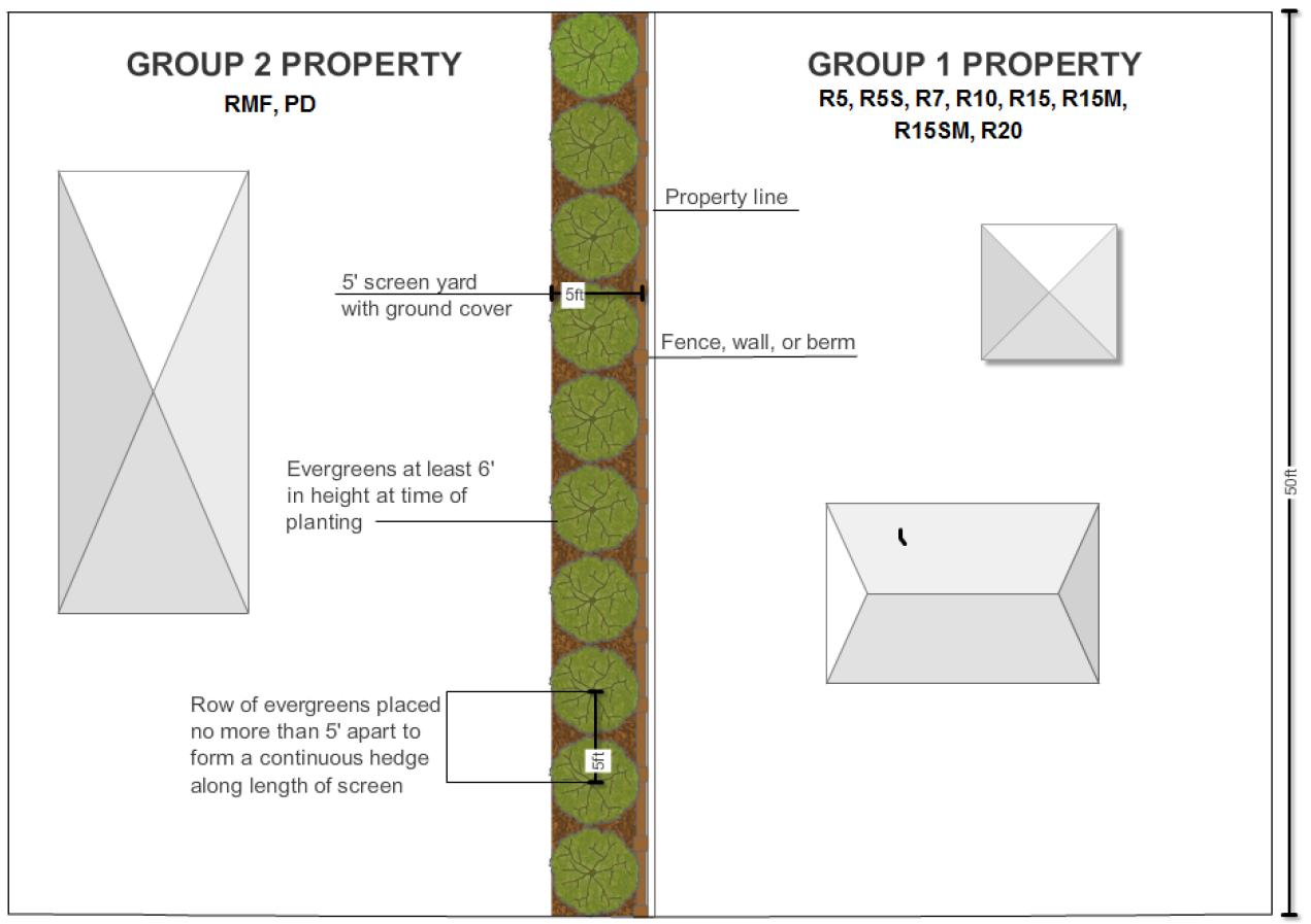
Example of Screen Type A
(2)
Screen "B": Following are the minimum requirements for a Screen "B":
(a)
Must meet the Screen "A" requirements of Subsection 15-5.1(D)(1); and
(b)
Additional five-foot screen width for a combined total screen yard width of ten (10) feet with an additional staggered row of evergreens:
1.
Additional staggered row of evergreens: Evergreens must be placed no more than thirty (30) feet apart.
2.
Evergreens must be no less than six (6) feet in height at the time of planting and must be capable of growth to at least fifteen (15) feet in height based upon the plant species and cultivar.
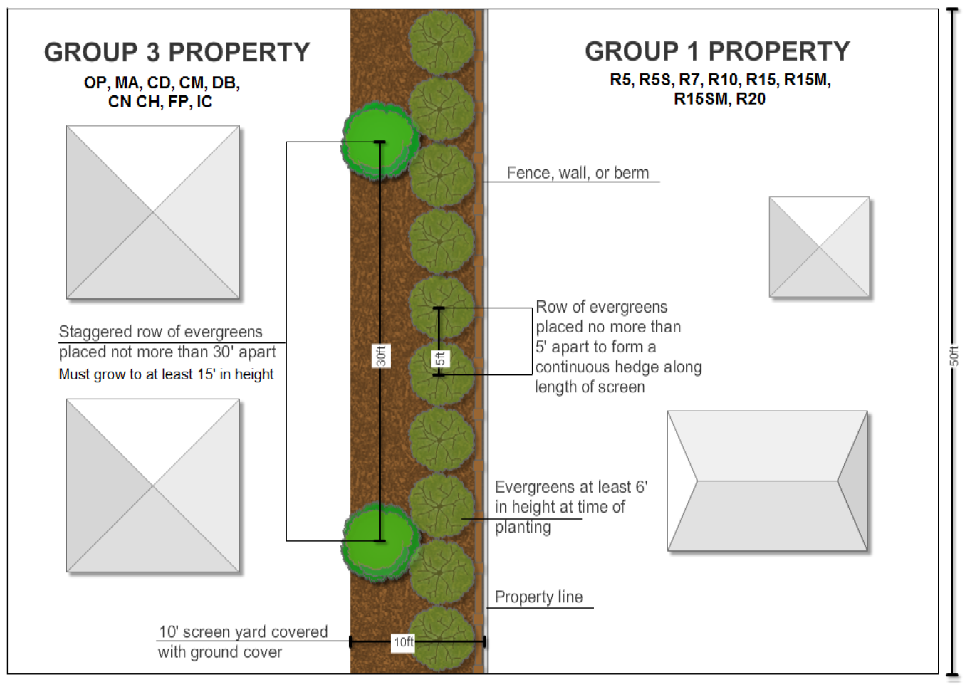
Example of Screen Type B
(3)
Screen "C": Following are the minimum requirements for a Screen "C":
(a)
Must meet the Screen "A" requirements of Subsection 15-5.1(D)(1); and
(b)
Additional five-foot screen width for a combined total screen yard width of ten (10) feet including an additional staggered row of evergreens:
1.
Evergreens must be placed no more than fifteen (15) feet apart.
2.
Evergreens must be no less than six (6) feet in height at the time of planting and must be capable of growth to at least twenty (20) feet in height based upon the plant species and cultivar.
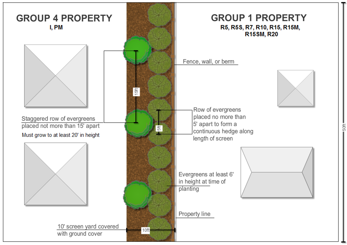
Example of Screen Type C
15-5.2
Landscape Strip Requirements.
(A)
10' Landscape Strip:
(1)
Required along the property line(s) which abut all rights-of-way on individual lots and along the property line(s) which abut major and minor thoroughfares in new major or minor subdivisions; and
(2)
Must meet the following requirements per one hundred (100) linear feet:
(a)
1 canopy or 2 understory trees and
(b)
12 shrubs; and
(3)
A combination of evergreen ground cover, mulch, shell, rock, and/or low-growing evergreen shrubs or other ground cover as approved by the Land Use Administrator shall cover the landscape strip along its entire length.
(B)
2.5' Landscape Strip: Required along the edge of off-street parking areas, alleys, vehicular access areas, internal driveways for parking areas which provide parking for five (5) or more vehicles.
(1)
Must meet the following requirements per one hundred (100) linear feet;
(a)
1 canopy tree or 2 understory trees; and
(b)
6 shrubs.
(2)
A combination of evergreen ground cover, mulch, shell, rock, and/or low-growing evergreen shrubs or other ground cover as approved by the Land Use Administrator shall cover the landscape strip along its entire length.
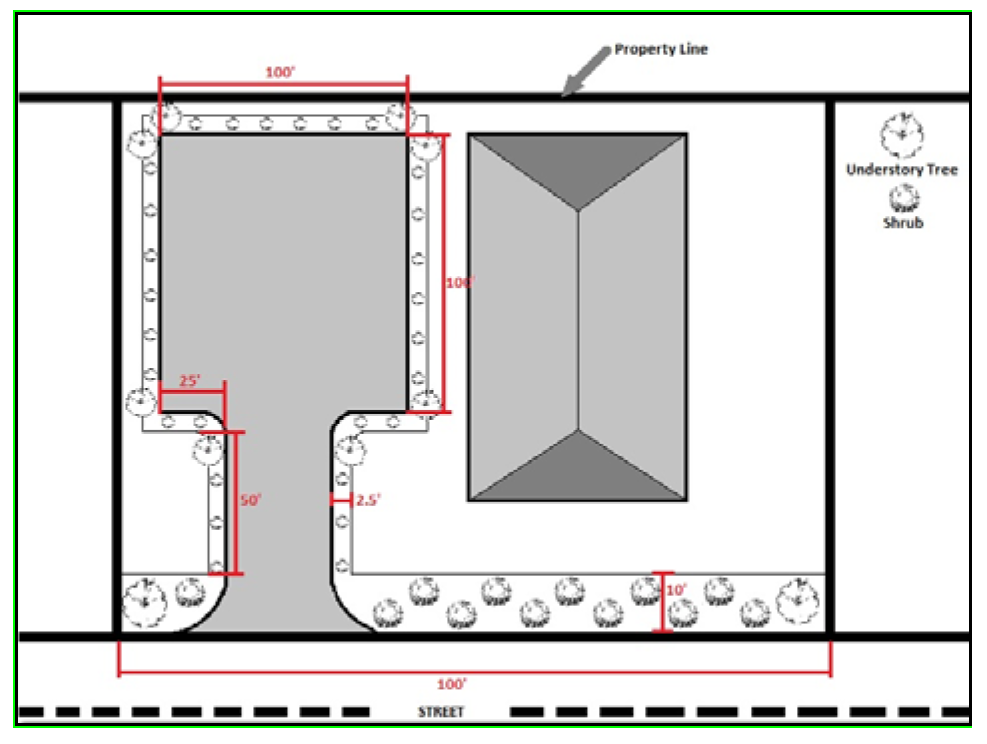
Example of 10' and 2.5' Landscape Strips
(3)
Bollards and chains may be used in the Downtown Business (DB) and Downtown Commercial (CD) districts in lieu of meeting the requirements of Subsection 15-5.2(B)(1) and 15-5.2(B)(2) above. The design and materials must be approved by the Morehead City Public Services Department.
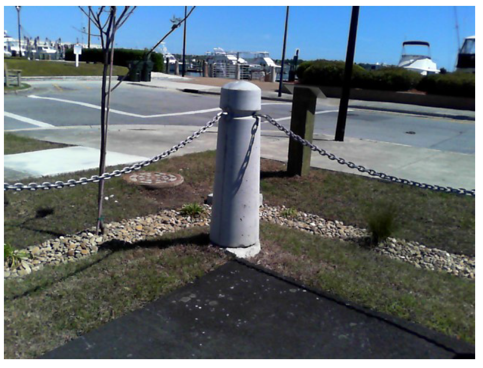
Type of Bollard and Chain Permitted in DB and CD Districts
15-5.3
Interior Parking Area Landscaping. Required in parking areas between parking spaces, at the end of parking bays, or in tree islands for new or redeveloped parking areas
(A)
Must meet the following requirements per twelve (12) parking spaces:
(1)
1 canopy or 2 understory trees
(B)
Parking area planting areas shall have a minimum area of two hundred (200) square feet and may not be less than seven (7) feet in any dimension.
(C)
Parking spaces must be located within the designated distance of a landscaped area as specified in Table 15-5.2.
Table 15-5.2 Parking Area Planters
(D)
Grouping of trees required under Subsection 15-5.3 is encouraged, even if this would reduce the number of landscape islands otherwise built within the parking lot.
15-6 - Landscape Plan Requirements
15-6.1
When required. A landscape plan is required in the following situations:
(A)
As part of submittal for a building permit for new construction, when applicable;
(B)
As part of a request for zoning site plan review, when applicable;
(C)
When a landscape screen, landscape strip, or interior parking area landscaping is required as stipulated under Section 15-5;
(D)
As part of a request for multifamily plan review;
(E)
As part of a request for special-use or conditional zoning district, when requested by staff, the Board of Adjustment, the Planning Board, or Council; and
(F)
Any other situation in which the requirements of this Article area applicable.
15-6.2
Required information. Landscape plans shall contain the following information:
(A)
Location(s) of proposed landscape screens, landscape strips, and interior parking area landscaping;
(B)
The location, species, and size of proposed plantings, landscape materials, and other landscape area materials (e.g. fences, berms, etc.);
(C)
Calculations verifying the required and proposed number of plantings per landscape area;
(D)
If tree preservation credits are requested, detailed information concerning the trees requested for credit must be provided and the requirements of Subsection 15-4.1(A) shall be met;
(E)
The location of existing or proposed power lines or other utilities with potential to interfere with existing or proposed landscape areas;
(F)
If the development is located within the corporate limits and/or is tying into the City water system and is to include an irrigation system, information about the type and coverage of the irrigation system;
(G)
Other information determined by Planning and Inspections Department staff to be necessary to facilitate review of the landscape plan.
15-6.3
Planning Board Approval of Certain Landscape Plans. Planning Board approval shall be required for the following landscape plans:
(A)
Landscaping plans for which the total area encompassed within the project parcel(s) is five (5) acres or greater.
(B)
Landscaping plans for multifamily developments for which Planning Board approval is required under Section 13-2.
(C)
Landscaping plans for which an alternate approval is requested. The process for alternate landscaping plan approval is provided under Section 15-6.4 below.
(Ord. No. 2025-O-04, 1-14-2025)
15-6.4
Major modification of the landscaping requirements of Sections 15-3, 15-4, and 15-5. In lieu of compliance with the landscaping and screening requirements of Sections 15-3, 15-4, and/or 15-5, an applicant may request that an alternate landscaping plan be approved by the Planning Board.
(A)
The Planning Board has the authority to adjust any requirements of Sections 15-3, 15-4, and 15-5 in accordance with this subsection.
(B)
In order for an alternate landscaping plan approval to be granted, one or more of the following conditions must exist:
(1)
The site involves space limitations or unusually-shaped parcels;
(2)
The topography, soil, vegetation, or other site conditions are such that full compliance is impossible or impractical;
(3)
The landscaping, if installed, would be located adjacent to a public alley;
(4)
Natural vegetation or other site conditions, if undisturbed during the development process, can meet or exceed the vegetation which is required; and/or
(5)
Safety conditions, such as the presence of overhead utility lines, are involved.
(C)
A request for alternate landscaping plan to modify the requirements of Sections 15-3, 15-4, and/or 15-5 must include the following:
(1)
A detailed site plan prepared in accordance with Subsection 15-6.2;
(2)
Information as to how the proposal will enhance the appearance of the property and provide protection of public and private investment;
(3)
Justification as to why an alternate landscaping plan is appropriate based upon the conditions set forth in Subsection 15-6.4(B);
(4)
Detailed information explaining which requirements will be met and which requirements are requested for modification; and
(5)
Information that demonstrates the proposal will meet or exceed the intent of the requirements of this Article.
15-6.5
Minor modification of landscaping requirements. Minor modification from the requirements of Article 15 may be approved or disapproved administratively by the Land Use Administrator. Minor modifications include the following:
(A)
Substitution of plant species based upon the requirements of Subsection 15-3.2(C);
(B)
Substitution of plant sizes;
(C)
Plant spacing requirements;
(D)
Relocation of plantings due to specific site conditions;
(E)
Crediting of tree preservation credits for plants located outside of credited landscape areas subject to 15-4.1(A)(3);
(F)
Similar minor modifications.
(Ord. No. 2025-O-04, 1-14-2025)
15-7 - Recreation and Open Space Requirements for Major and Minor Residential Subdivision
15-7.1
Provisions for land dedication or fees in lieu of dedication. A provision for land dedication or fees in lieu of dedication for recreation and open space areas shall be provided for major and minor residential subdivisions of land.
(A)
Recreation/Open Space Area Formula: If land is to be dedicated to the City, Carteret County, or the homeowners association in accordance with this section, the total area shall be based upon one thousand two hundred (1,200) square feet per subdivision lot.
(1)
Formula: 1200 square feet × Number of subdivision lots
(B)
Recreation/Open Space Fee Formula. Subject to City Council approval and in accordance with this section, the amount of fees required in lieu of recreation and open space area dedication shall be based upon the area generated under the Recreation/Open Space Area Formula in Subsection 15-7.1(A), multiplied by the value of the land per acre using tax value.
(1)
Formula: Area generated in the Recreation/Open Space Formula × value of land per acre = the amount of recreation fees due in lieu of dedication.
(2)
Example:
10-lot residential subdivision with a value of land per acre based upon tax value of $40,000:
1,200 square feet × 10 lots = 12,000 square feet or 0.28 acre
Value of land per acre based upon tax value = $40,000.00
$40,000.00 × 0.28 = $11,200.00
(C)
Residential subdivisions shall be required to either:
(1)
Offer a portion of the subdivision to the City for purposes of recreation and open space to serve the recreation district; or
(2)
Provide fees in lieu of dedication based upon the Recreation/Open Space Fee Formula in Subsection 15-7.1(B).
(D)
The following subdivisions shall be subject to a provision for the payment of fees in lieu of land dedication for purposes of recreation and open space:
(1)
Residential subdivisions with a total gross area of five (5) acres or less.
(2)
Residential subdivisions which do not generate a minimum of one (1) acre of recreation and open space area based upon the Recreation/Open Space Area Formula.
(E)
The City Council shall determine which alternative under Subsection 15-7.1(C) above is most appropriate based upon the following criteria:
(1)
The proximity of the subdivision to an existing recreation or open space area;
(2)
The density and size of the subdivision; and
(3)
The developer's interest in providing a developed/improved recreation area with active and/or passive uses to serve the residents of the subdivision.
(a)
In the event that a developer desires to develop or improve a recreation area, plans for the developed/improved recreation areas shall be submitted to the City Council as part of sketch plan approval.
(b)
The City Council may opt to accept a developed/improved recreation area in lieu of a recreation fee.
(F)
Land dedications required under this section shall be applicable to subdivisions within the City corporate limits and extraterritorial jurisdiction.
(G)
Land shall be offered to the City or fees shall be paid in lieu of dedication in accordance with the requirements of this section prior to recordation of the final plat.
(H)
In the event that the City Council declines the offer, the land dedication shall be offered to Carteret County. If neither the City Council nor Carteret County accepts the offer of dedication, the land shall be conveyed to a homeowners association.
(I)
Subject to approval by the City Council, an open space area or improved recreation area may be offered for dedication to the homeowners association.
15-7.2
Suitability of land for recreation or open space dedication.
(A)
Location.
(1)
Land dedicated under this section shall be so located so as to serve the recreation needs of the subdivision or neighborhood.
(B)
Land unity.
(1)
The land to be dedicated shall be a single parcel unless it is determined that two (2) or more parcels would be in the public interest.
(C)
Accessibility.
(1)
Access to dedicated land shall be provided by an abutting street or easement.
(2)
If access is provided via an easement, or if it is necessary to provide a connecting path to connect two (2) or more parcels, the access or connecting path shall not be less than thirty (30) feet and not more than sixty (60) feet in width.
(3)
The area in the connecting path shall be in addition to the minimum land required for dedication.
(D)
Use of dedicated land.
(1)
Dedicated land shall be usable for active recreation, such as play areas, ballfields, tennis courts, or similar recreation uses.
(2)
Ponds, basins, lakes, and other water bodies may not be included within recreation areas required under this section unless approved by the City Council.
(E)
Conservation and historic preservation.
(1)
Conservation and historic preservation easements shall comply with the Conservation and Historic Preservation Agreements Act (G.S. 121-34—121-42).
(2)
Facilities, improvements, and open space areas offered for dedication to the public shall be maintained by the owner until such offer of dedication is accepted by the appropriate public authority.
15-7.3
Recreation funds.
(A)
All funds received by the City pursuant to this section shall be used only for the acquisition or development of recreation, park or open space sites.
15-7.4
Adjustments.
(A)
The City may, in cases of unusual or exceptional nature, allow adjustments in the requirements of this section.
(B)
Such adjustments shall be reviewed and approved by the City Council.
15-7.5
Excess dedication.
(A)
If the land required for open space and recreation is in a section or phase of a subdivision which exceeds the requirement in the Recreation/Open Space Area Formula, the difference may be applied to future sections or phases of the subdivision.
(B)
In the event that a City Council desires recreation and open space land in excess of the amount required in the Recreation/Open Space Area Formula, the subdivider and City Council shall negotiate a fair price and the City shall pay the full negotiated price.
15-7.6
Reversionary clause.
(A)
In the event that a homeowners association dissolves, liquidates its assets, or otherwise ceases to maintain a park, recreation, or open space area, the title of said park, recreation, or open space area shall revert to the City or Carteret County. The City shall have the right of first refusal.
(B)
Subject to approval by the City Council, a developer, property owner, or homeowners association may sell, develop, or otherwise revert a recorded recreation/open space area to private property provided a fee is paid in accordance with the Recreation/Open Space Fee Formula.
(C)
All protective covenants, declarations, and homeowners bylaws applicable to the subdivision shall contain provisions legally sufficient to accomplish these directives.
15-7.7
Recreation areas shown on subdivision plat.
(A)
If the approved sketch plan showed future recreation areas not included in the section for which final plat approval is sought, the developer shall post a guarantee in the amount determined by the Recreation/Open Space Area Fee Formula prior to final plat approval.
(B)
If the amount of recreation area required by this Ordinance is not developed within one (1) year of final plat approval, a fee in the amount of the Recreation/Open Space Area Fee Formula shall be due immediately.
(Ord. No. 2025-O-04, 1-14-2025)
15-8 - Required Public Water Access for Major and Minor Subdivisions
15-8.1
Public water access area requirement.
(A)
Every person who subdivides land for residential purposes with direct waterfront access shall be required to provide public access to the water or fees in lieu of dedication.
(B)
The water access easement shall be offered for dedication to the public.
15-8.2
Public water access area specifications.
(A)
Subdivisions that provide water access shall be required to have at least one (1) useable fifteen-foot water access easement. An additional fifteen-foot water access easement shall be provided for each one thousand two hundred (1,200) feet of shoreline.
(B)
Each easement shall be directly accessible to a public street or road.
(C)
Streets offered for dedication which run to the mean high water mark may count towards the requirements of this section.
(D)
Plans for the developed/improved water access areas shall be submitted to the City Council as part of sketch plan approval.
15-8.3
Maintenance of public water access areas.
(A)
Maintenance of water access easements required under this section shall be the responsibility of the homeowners association unless the City has accepted dedication.
(B)
At such time as dedication of a water access easement is accepted by the City, the access easement shall be open to the public and maintained by the City.
15-8.4
Fees in lieu of dedication.
(A)
Subject to approval by the City Council, a subdivider may provide funds in lieu of providing public water access based upon factors listed in Subsection 15-8.4(C).
(B)
If the Council determines that it is acceptable for the developer to pay a fee in lieu of dedication, the amount shall be based upon one thousand dollars ($1,000.00) per unit/lot.
(C)
The Council will use factors such as the proximity of other local public water access points, the likelihood of the public utilizing public water access on the site, whether the site has traditionally been used as a public water access point, the density and size of the subdivision, as well as other factors to determine whether to accept the fee in lieu of dedication.
(Ord. No. 2025-O-04, 1-14-2025)