
Morehead City City Zoning Code
ARTICLE 18
- FLOOD DAMAGE PREVENTION ORDINANCE
COASTAL REGULAR PHASE
18-1 - Statutory Authorization, Findings of Fact, Purpose and Objectives
18-1.1
Statutory authorization. The Legislature of the State of North Carolina has in Part 6, Article 21 of Chapter 143; Article 6 of Chapter 153A; Article 8 of Chapter 160A; and Article 7, 9, and 11 of Chapter 160D (Effective July 1, 2021) of the North Carolina General Statutes, delegated to local governmental units the authority to adopt regulations designed to promote the public health, safety, and general welfare.
Therefore, the City Council of Morehead City, North Carolina, does ordain as follows:
18-1.2
Findings of fact.
(A)
The floodprone areas within the jurisdiction of Morehead City, North Carolina, are subject to periodic inundation which results in loss of life, property, health and safety hazards, disruption of commerce and governmental services, extraordinary public expenditures of flood protection and relief, and impairment of the tax base, all of which adversely affect the public health, safety, and general welfare.
(B)
These flood losses are caused by the cumulative effect of obstructions in floodplains causing increases in flood heights and velocities, and by the occupancy in floodprone areas by uses vulnerable to floods or hazardous to other lands which are inadequately elevated, floodproofed, or otherwise unprotected from flood damages.
18-1.3
Statement of purpose. It is the purpose of this Ordinance to promote public health, safety, and general welfare and to minimize public and private losses due to flood conditions within floodprone areas by provisions designed to:
(A)
Restrict or prohibit uses which are dangerous to health, safety, and property due to water or erosion hazards, or which result in damaging increases in erosion, flood heights or velocities;
(B)
Require that uses vulnerable to floods, including facilities which serve such uses, be protected against flood damage at the time of initial construction;
(C)
Control the alteration of natural floodplains, stream channels, and natural protective barriers, which are involved in the accommodation of floodwaters.
(1)
Control filling, grading, dredging, and all other development which may increase erosion or flood damage; and
(2)
Prevent or regulate the construction of flood barriers which will unnaturally divert floodwaters or which may increase flood hazards to other lands.
18-1.4
Objectives. The objectives of this Ordinance are:
(A)
To protect human life and health;
(B)
To minimize expenditure of public money for costly flood control projects;
(C)
To minimize the need for rescue and relief efforts associated with flooding and generally undertaken at the expense of the general public;
(D)
To minimize prolonged business losses and interruptions;
(E)
To minimize damage to public facilities and utilities (i.e. water and gas mains, electric, telephone, cable and sewer lines, streets, and bridges) that are located in floodprone areas;
(F)
To help maintain a stable tax base by providing for the sound use and development of floodprone areas in such a manner as to minimize flood blight areas; and
(G)
To ensure that potential homebuyers are notified that property is in a special flood hazard area.
(Ord. No. 2025-O-04, 1-14-2025)
18-2 - Definitions
18-2.1
See Article 2, Basic Definitions and Interpretations.
18-3 - General Provisions
18-3.1
Lands to which this Ordinance applies. This Ordinance shall apply to all special flood hazard areas within the jurisdiction, including extra-territorial jurisdictions (ETJ) if applicable, of Morehead City, North Carolina, and within the jurisdiction of any other community whose governing body agrees, by resolution, to such applicability.
18-3.2
Basis for establishing the special flood hazard areas. The Special Flood Hazard Areas are those identified under the Cooperating Technical State (CTS) agreement between the State of North Carolina and FEMA in its FIS for the City dated February 16, 1977, and May 15, 1980, and associated DFIRM panels, including any digital data developed as part of the FIS, which are adopted by reference and declared a part of this ordinance, and all revisions thereto. The special flood hazard areas also include those defined through standard engineering analysis for private developments or by governmental agencies, but which have not yet been incorporated in the FIRM. This includes, but is not limited to, detailed flood data:
(A)
Generated as a requirement of Subsection 18-4.5(K) and (L) of this Ordinance;
(B)
Preliminary FIRMs where more stringent than the effective FIRM; or
(C)
Post-disaster flood recovery maps.
In addition, upon annexation to Morehead City or inclusion in the extra-territorial jurisdiction (ETJ), the special flood hazard areas identified by the Federal Emergency Management Agency (FEMA) and/or produced under the Cooperating Technical State agreement between the State of North Carolina and FEMA as stated above for the unincorporated areas of Carteret County, with accompanying maps and other supporting data, and any revision thereto, are adopted by reference and declared to be a part of this Ordinance.
18-3.3
Establishment of floodplain development permit. A floodplain development permit shall be required in conformance with the provisions of this Ordinance prior to the commencement of any development activities within special flood hazard areas as determined in Subsection 18-3.2.
18-3.4
Compliance. No structure or land shall hereafter be located, extended, converted, altered, or developed in any way without full compliance with the terms of this Ordinance and other applicable regulations.
18-3.5
Abrogation and greater restriction. This Ordinance is not intended to repeal, abrogate, or impair any existing easements, covenants, or deed restrictions. However, where this Ordinance and another conflict or overlap, whichever imposes the more stringent restrictions shall prevail.
18-3.6
Interpretation. In the interpretation and application of this Ordinance, all provisions shall be:
(A)
Considered as minimum requirements;
(B)
Liberally construed in favor of the governing body; and
(C)
Deemed neither to limit nor repeal any other powers granted under state statutes.
18-3.7
Warning and disclaimer of liability. The degree of flood protection required by this Ordinance is considered reasonable for regulatory purposes and is based on scientific and engineering consideration. Larger floods can and will occur on rare occasions. Actual flood heights may be increased by man-made or natural causes. This Ordinance does not imply that land outside the special flood hazard areas or uses permitted within such areas will be free from flooding or flood damages. This Ordinance shall not create liability on the part of Morehead City or by any officer or employee thereof for any flood damages that result from reliance on this Ordinance or any administrative decision lawfully made hereunder.
18-3.8
Penalties for violation. Violation of the provisions of this Ordinance or failure to comply with any of its requirements, including violation of conditions and safeguards established in connection with grants of variance or special exceptions, shall constitute a misdemeanor. Any person who violates this Ordinance or fails to comply with any of its requirements shall, upon conviction thereof, be fined not more than fifty dollars ($50.00) or imprisoned for not more than thirty (30) days, or both. Each day such violation continues shall be considered a separate offense. Nothing herein contained shall prevent Morehead City from taking such other lawful action as is necessary to prevent or remedy any violation.
(Ord. No. 2025-O-04, 1-14-2025)
18-4 - Administration
18-4.1
Designation of Floodplain Administrator. The holder of the office of chief building inspector, or his/her designee, hereinafter referred to as the "Floodplain Administrator," is hereby appointed to administer and implement the provisions of this Ordinance.
18-4.2
Floodplain development permit and certification requirements.
18-4.2.1
Plans and application requirements. Application for a floodplain development permit shall be made to the Floodplain Administrator on forms furnished by him or her prior to any development activities proposed to be located within floodprone areas. The following items/information shall be presented to the Floodplain Administrator to apply for a floodplain development permit.
(A)
A plot plan drawn to scale which shall include, but shall not be limited to, the following specific details of the proposed floodplain development:
(1)
The nature, location, dimensions, and elevations of the area of development/disturbance, existing and proposed structures, the location of utility systems, proposed grading/pavement areas, fill materials, storage areas, drainage facilities, and other proposed development;
(2)
The boundary of the special flood hazard area as delineated on the FIRM or other flood map as determined in Subsection 18-3.2 or a statement that the entire lot is within the special flood hazard area;
(3)
Flood zone(s) designation of the proposed development area as determined on the FIRM or other flood map as determined in Subsection 18-3.2;
(4)
The boundary of the floodway(s) or nonencroachment area(s) as determined in Section 18-3.2;
(5)
The base flood elevation (BFE) where provided as set forth in Subsection 18-3.2; Subsection 18-4.5(K) and (L); Subsection 18-5.3, Subsection 18-5.4 or Subsection 18-5.2(E);
(6)
The old and new location of any watercourse that will be altered or relocated as a result of proposed development;
(7)
Preparation of the plot plan by or under the direct supervision of a registered land surveyor or professional engineer and certified by same.
(B)
Proposed elevation, and method thereof, of all development within a special flood hazard area, including, but not limited to:
(1)
Elevation in relation to mean sea level of the proposed reference level (including basement) of all structures;
(2)
Elevation in relation to mean sea level to which any nonresidential structure will be floodproofed;
(3)
Elevation in relation to mean sea level to which any proposed utility systems will be elevated or floodproofed.
(C)
If floodproofing, a floodproofing certificate and back-up plans from a registered professional engineer or architect certifying that the nonresidential floodproofed development will meet the floodproofing criteria in Subsection 18-5.2 and Subsection 18-5.3.
(D)
A foundation plan drawn to scale which shall include details of the proposed foundation system to ensure all provisions of this Ordinance are met. These details include, but are not limited to:
(1)
Proposed method of elevation, if applicable (i.e., fill, solid foundation perimeter wall, solid backfilled foundation, open foundation on columns/piers);
(2)
Should solid foundation perimeter walls be used in floodplains other than coastal high hazard areas, details of sufficient openings to facilitate the unimpeded movements of floodwaters in accordance with Subsection 18-5.2(D);
(3)
In coastal high hazard areas, the following must also be submitted prior to floodplain development permit issuance. Specific requirements are detailed in Subsection 18-5.6 and Subsection 18-5.2(D) of this Code.
(a)
V-zone certification form with accompanying plans and specifications verifying the engineered structure and breakaway wall designs as set forth in Subsection 18-5.2(D)(2) of this Code;
(b)
Plans for lattice work or decorative screening, if applicable. Plans for any structures that will have lattice work or decorative screening must be submitted to the Floodplain Administrator for approval prior to floodplain development permit issuance;
(c)
Plans for nonstructural fill, if applicable. Plans for placement of any nonstructural fill must be submitted to the Floodplain Administrator for approval prior to floodplain development permit issuance. Requirements are detailed in Subsection 18-5.7(H) of this Code.
(E)
Usage details of any enclosed space below the regulatory flood protection elevation.
(F)
Plans and/or details for the protection of public utilities and facilities such as sewer, gas, electrical, and water systems to be located and constructed to minimize flood damage;
(G)
Copy of all other local, state and federal permits required prior to floodplain development permit issuance (i.e., wetlands, erosion and sedimentation control, CAMA, riparian buffers, mining, etc.)
(H)
If floodplain development permit is issued for placement of recreational vehicles and/or temporary structures, documentation to ensure Subsection 18-5.2(F) and (G) of this Code are met.
(I)
If a watercourse is proposed to be altered and/or relocated, a description of the extent of watercourse alteration or relocation; an engineering report on the effects of the proposed project on the flood-carrying capacity of the watercourse and the effects to properties located both upstream and downstream; and a map (if not shown on plot plan) showing the location of the proposed watercourse alteration or relocation.
18-4.2.2
Floodplain development permit data requirements. The following information shall be provided at a minimum on the floodplain development permit to ensure compliance with this Code.
(A)
A description of the development to be permitted under the floodplain development permit issuance.
(B)
The special flood hazard area determination for the proposed development per available data specified in Subsection 18-3.2.
(C)
The regulatory flood protection elevation required for the reference level and all attendant utilities.
(D)
The regulatory flood protection elevation required for the protection of all public utilities.
(E)
All certification submittal requirements with timelines.
(F)
State that no fill material shall encroach into the floodway or nonencroachment area of any watercourse, if applicable.
18-4.2.3
Certification requirements.
(A)
An elevation certificate (FEMA Form 81-31) or floodproofing certificate (FEMA Form 81-65) is required after the reference level is completed. Within twenty-one (21) calendar days of establishment of the reference level elevation, or floodproofing, by whatever construction means, whichever is applicable, it shall be the duty of the permit holder to submit to the Floodplain Administrator a certification of the elevation of the reference level, or floodproofed elevation, whichever is applicable in relation to mean sea level. Said certification shall be prepared by or under the direct supervision of a registered land surveyor or professional engineer and certified by same. When floodproofing is utilized, said certification shall be prepared by or under the direct supervision of a professional engineer or architect and certified by same. Any work done within the twenty-one-day calendar period and prior to submission of the certification shall be at the permit holder's risk. The Floodplain Administrator shall review the certificate data submitted. Deficiencies detected by such review shall be corrected by the permit holder immediately and prior to further progressive work being permitted to proceed. Failure to submit the certification or failure to make said corrections required shall be cause to issue a stop-work order for the project.
(B)
A final as-built elevation certificate (FEMA Form 81-31) or floodproofing certificate (FEMA Form 81-65) is required after construction is completed and prior to certificate of compliance/occupancy issuance. It shall be the duty of the permit holder to submit to the Floodplain Administrator a certification of final as-built construction of the elevation or floodproofed elevation of the reference level and all attendant utilities. Said certification shall be prepared by or under the direct supervision of a registered land surveyor or professional engineer and certified by same. When floodproofing is utilized, said certification shall be prepared by or under the direct supervision of a professional engineer or architect and certified by same. The Floodplain Administrator shall review the certificate data submitted. Deficiencies detected by such review shall be corrected by the permit holder immediately and prior to certificate of compliance/occupancy issuance. In some instances, another certification may be required to certify corrected as-built construction. Failure to submit the certification or failure to make said corrections required shall be cause to withhold the issuance of a certificate of compliance/occupancy.
(C)
A V-zone/breakaway wall certification is required prior to issuance of a floodplain development permit within coastal high hazard areas. It shall be the duty of the permit applicant to submit to the Floodplain Administrator said certification to ensure the design standards of this Ordinance are met. A registered professional engineer or architect shall develop or review the structural design, plans, and specifications for construction and certify that the design and methods of construction to be used are in accordance with accepted standards of practice for meeting the provisions of this Ordinance. This certification is not a substitute for an elevation certificate.
(D)
If a manufactured home is placed within an A, AO, AE, or A1—30 zone and the elevation of the chassis is above thirty-six (36) inches in height, an engineered foundation certification is required per Subsection 18-5.2(C).
(E)
If a watercourse is to be altered or relocated, a description of the extent of watercourse alteration or relocation; an engineering report on the effects of the proposed project on the flood-carrying capacity of the watercourse and the effects to properties located both upstream and downstream; and a map showing the location of the proposed watercourse alteration or relocation shall all be submitted by the permit applicant prior to issuance of a floodplain development permit.
(F)
Certification exemptions. The following structures, if located within an A, AO, AE or A1—30 zone, are exempt from the elevation/floodproofing certification requirements specified in items (A) and (B) above:
(1)
Recreational vehicles meeting requirements of Subsection 18-5.2(F)(1);
(2)
Temporary structures meeting requirements of Subsection 18-5.2(G); and
(3)
Accessory structures less than one hundred fifty (150) square feet meeting requirements of Subsection 18-5.2(H).
18-4.3
Reserved.
18-4.4
Reserved.
18-4.5
Duties and responsibilities of the Floodplain Administrator. Duties of the Floodplain Administrator shall include, but not be limited to:
(A)
Review all floodplain development applications and issue permits for all proposed development with in floodprone areas to assure that the requirements of this Ordinance have been satisfied.
(B)
Advise permittee that additional federal or state permits (i.e. wetlands, erosion and sedimentation control, CAMA, riparian buffers, mining, etc.) may be required, and if specific federal or state permits are known, require that copies of such permits be provided and maintained on file with the floodplain development permit.
(C)
Notify adjacent communities and the North Carolina Department of Crime Control and Public Safety, Division of Emergency Management, State Coordinator for the National Flood Insurance Program prior to any alteration or relocation of a watercourse, and submit evidence of such notification to the Federal Emergency Management Agency.
(D)
Assure that maintenance is provided within the altered or relocated portion of said watercourse so that the flood-carrying capacity is not diminished.
(E)
Prevent encroachments within floodways and nonencroachment areas unless the certification and flood hazard reduction provisions of Subsection 18-5.5.
(F)
Obtain actual elevation (in relation to mean sea level) of the reference level (including basement) of all attendant utilities of all new or substantially improved structures, in accordance with Subsection 18-4.2.3.
(G)
Obtain the actual elevation (in relation to mean sea level) to which the new or substantially improved structures and all utilities have been floodproofed, in accordance with Subsection 18-4.2.3.
(H)
Obtain actual elevation (in relation to mean sea level) of all public utilities, in accordance with Subsection 18-4.2.3.
(I)
When floodproofing is utilized for a particular structure, obtain certifications from a registered professional engineer or architect in accordance with Subsection 18-4.2.3 and Subsection 18-5.2(B).
(J)
Where interpretation is needed as to the exact location of boundaries of the special flood hazard areas (for example, where there appears to be a conflict between a mapped boundary and actual field conditions), make the necessary interpretation. The person contesting the location of the boundary shall be given a reasonable opportunity to appeal the interpretation as provided in this Article.
(K)
When base flood elevation (BFE) data has not been provided in accordance with Subsection 18-3.2, obtain, review, and reasonably utilize any base flood elevation (BFE) data, along with floodway data and/or nonencroachment area data available from a federal, state, or other source including data developed pursuant to Subsection 18-5.3(D), in order to administer the provisions of this Ordinance.
(L)
When base flood elevation (BFE) data is provided but no floodway nor nonencroachment area data has been provided in accordance with Subsection 18-3.2, obtain, review, and reasonably utilize any floodway data, and/or nonencroachment area data available from a federal, state, or other source in order to administer the provisions of this Ordinance.
(M)
When the exact location of boundaries of the special flood hazard areas conflict with the current, natural topography information at the site, the property owner may apply and be approved for a letter of map amendment (LOMA) by FEMA. A copy of the letter of map amendment issued from FEMA will be maintained by the Floodplain Administrator in the floodplain development permit file.
(N)
Permanently maintain all records that pertain to the administration of this Ordinance and make these records available for public inspection.
(O)
Make on-site inspections of work in progress. As the work pursuant to a floodplain development permit progresses, the Floodplain Administrator shall make as many inspections of the work as may be necessary to ensure that the work is being done according to the provisions of the local ordinance and the terms of the permit. In exercising this power, the Floodplain Administrator has a right, upon presentation of proper credentials, to enter on any premises within the jurisdiction of the community at any reasonable hour for the purposes of inspection or other enforcement action.
(P)
Issue stop-work orders as required. Whenever a building or part thereof is being constructed, reconstructed, altered, or repaired in violation of this Ordinance, the Floodplain Administrator may order the work to be immediately stopped. The stop-work order shall be in writing and directed to the person doing the work. The stop-work order shall state the specific work to be stopped, the specific reason(s) for the stoppage, and the condition(s) under which the work may be resumed. Violation of a stop-work order constitutes a misdemeanor.
(Q)
Revocation of floodplain development permits as required. The Floodplain Administrator may revoke and require the return of the floodplain development permit by notifying the permit holder in writing stating the reason(s) for the revocation. Permits shall be revoked for any substantial departure from the approved application, plans, or specifications; for refusal or failure to comply with the requirements of state or local laws; or for false statements or misrepresentations made in securing the permit. Any floodplain development permit mistakenly issued in violation of an applicable state or local law may also be revoked.
(R)
Make periodic inspections throughout all special flood hazard areas within the jurisdiction of the community. The Floodplain Administrator and each member of his or her inspections department shall have a right, upon presentation of proper credentials, to enter on any premises within the territorial jurisdiction of the department at any reasonable hour for the purposes of inspection or other enforcement action.
(S)
Follow through with corrective procedures of Subsection 18-4.6.
18-4.6
Corrective procedures.
(A)
Violations to be corrected. When the Floodplain Administrator finds violations of applicable State and local laws, it shall be his or her duty to notify the owner or occupant of the building of the violation. The owner or occupant shall immediately remedy each of the violations of law pertaining to their property.
(B)
Actions in event of failure to take corrective action. If the owner of a building or property shall fail to take prompt corrective action, the Floodplain Administrator shall give the owner written notice, by certified or registered mail to the owner's last known address or by personal service, stating:
(1)
That the building or property is in violation of the flood damage prevention ordinance;
(2)
That a hearing will be held before the Floodplain Administrator at a designated place and time, not later than ten (10) days after the date of the notice, at which time the owner shall be entitled to be heard in person or by counsel and to present arguments and evidence pertaining to the matter; and
(3)
That following the hearing, the Floodplain Administrator may issue such order to alter, vacate, or demolish the building; or to remove fill as appears appropriate.
(C)
Order to take corrective action. If, upon a hearing held pursuant to the notice prescribed above, the Floodplain Administrator shall find that the building or development is in violation of the flood damage prevention ordinance, he or she shall make an order in writing to the owner, requiring the owner to remedy the violation within a specified time period, not less than sixty (60) days. Where the Floodplain Administrator finds that there is imminent danger to life or other property, he may order that corrective action be taken in such lesser period as may be feasible.
(D)
Appeal. Any owner who has received an order to take corrective action may appeal the order to the local elected governing body by giving notice of appeal in writing to the Floodplain Administrator and the clerk within ten (10) days following issuance of the final order. In the absence of an appeal, the order of the Floodplain Administrator shall be final. The local governing body shall hear an appeal within a reasonable time and may affirm, modify and affirm, or revoke the order.
(E)
Failure to comply with order. If the owner of a building or property fails to comply with an order to take corrective action from which no appeal has been taken, or fails to comply with an order of the governing body following an appeal, he shall be guilty of a misdemeanor and shall be punished in the discretion of the court.
18-4.7
Variance procedure.
(A)
The Board of Adjustment as established by the City Council of Morehead City, hereinafter referred to as the "Appeal Board", shall hear and decide requests for variances from the requirements of this Ordinance.
(B)
Any person aggrieved by the decision of the Appeal Board may appeal such decision to the Court, as provided in G.S. Chapter 7A.
(C)
Variances may be issued for the repair or rehabilitation of historic structures upon the determination that the proposed repair or rehabilitation will not preclude the structure's continued designation as a historic structure and the variance is the minimum necessary to preserve the historic character and design of the structure.
(D)
In passing upon variances, the Appeal Board shall consider all technical evaluations, all relevant factors, all standards specified in other sections of this Ordinance, and:
(1)
The danger that materials may be swept onto other lands to the injury of others;
(2)
The danger to life and property due to flooding or erosion damage;
(3)
The susceptibility of the proposed facility and its contents to flood damage and the effect of such damage on the individual owner;
(4)
The importance of the services provided by the proposed facility to the community;
(5)
The necessity to the facility of a waterfront location, where applicable;
(6)
The availability of alternative locations, not subject to flooding or erosion damage, for the proposed use;
(7)
The compatibility of the proposed use with existing and anticipated development;
(8)
The relationship of the proposed use to the comprehensive plan and floodplain management program for that area;
(9)
The safety of access to the property in times of flood for ordinary and emergency vehicles;
(10)
The expected heights, velocity, duration, rate of rise, and sediment transport of the floodwaters and the effects of wave action, if applicable, expected at the site; and
(11)
The costs of providing governmental services during and after flood conditions including maintenance and repair of public utilities and facilities such as sewer, gas, electrical and water systems, and streets and bridges.
(E)
A written report addressing each of the above factors shall be submitted with the application for a variance.
(F)
Upon consideration of the factors listed above and the purposes of this Ordinance, the Appeal Board may attach such conditions to the granting of variances as it deems necessary to further the purposes of this Ordinance.
(G)
Variances shall not be issued within any designated floodway or nonencroachment area if any increase in flood levels during the base flood discharge would result.
(H)
Conditions for variances:
(1)
Variances may not be issued when the variance will make the structure in violation of other federal, state, or local laws, regulations, or ordinances.
(2)
Variances shall only be issued upon a determination that the variance is the minimum necessary, considering the flood hazard, to afford relief.
(3)
Variances shall only be issued upon:
(a)
A showing of good and sufficient cause;
(b)
A determination that failure to grant the variance would result in exceptional hardship; and
(c)
A determination that the granting of a variance will not result in increased flood heights, additional threats to public safety, or extraordinary public expense, create nuisance, cause fraud on or victimization of the public, or conflict with existing local laws or ordinances.
(4)
Any applicant to whom a variance is granted shall be given written notice specifying the difference between the base flood elevation (BFE) and the elevation to which the structure is to be built and a written statement that the cost of flood insurance will be commensurate with the increased risk resulting from the reduced reference level elevation. Such notification shall be maintained with a record of all variance actions.
(5)
The Floodplain Administrator shall maintain the records of all appeal actions and report any variances to the Federal Emergency Management Agency and the State of North Carolina upon request.
(Ord. No. 2025-O-04, 1-14-2025)
18-5 - Provisions for Flood Hazard Reduction
18-5.1
General standards. In all special flood hazard areas the following provisions are required:
(A)
All new construction and substantial improvements shall be anchored to prevent flotation, collapse, or lateral movement of the structure.
(B)
All new construction and substantial improvements shall be constructed with materials and utility equipment resistant to flood damage.
(C)
All new construction or substantial improvements shall be constructed by methods and practices that minimize flood damages.
(D)
Electrical, heating, ventilation, plumbing, air conditioning equipment, and other service facilities shall be designed and/or located so as to prevent water from entering or accumulating within the components during conditions of flooding. These include, but are not limited to, HVAC equipment, water softener units, bath/kitchen fixtures, ductwork, electric meter panels/boxes, utility/cable boxes, appliances (i.e., washers, dryers, refrigerator, etc.), hot water heaters, electric outlets/switches.
(E)
All new and replacement water supply systems shall be designed to minimize or eliminate infiltration of floodwaters into the system.
(F)
New and replacement sanitary sewage systems shall be designed to minimize or eliminate infiltration of floodwaters into the systems and discharges from the systems into floodwaters.
(G)
On-site waste disposal systems shall be located and constructed to avoid impairment to them or contamination from them during flooding.
(H)
Any alteration, repair, reconstruction, or improvements to a structure which is in compliance with the provisions of this Ordinance, shall meet the requirements of "new construction" as contained in this Ordinance.
(I)
Nonconforming structures or other development may not be enlarged, replaced, or rebuilt unless such enlargement or reconstruction is accomplished in conformance with the provisions of this Ordinance. Provided, however, nothing in this Ordinance shall prevent the repair, reconstruction, or replacement of a building or structure existing on the effective date of this Ordinance and located totally or partially within the floodway, nonencroachment area, or stream setback, provided that the bulk of the building or structure below the regulatory flood protection elevation in the floodway, nonencroachment area, or stream setback is not increased and provided that such repair, reconstruction, or replacement meets all of the other requirements of this Ordinance.
(J)
New solid waste disposal facilities, hazardous waste management facilities, salvage yards, and chemical storage facilities shall not be permitted in special flood hazard areas. A structure or tank for chemical or fuel storage incidental to an allowed use or to the operation of a water treatment plant or wastewater treatment facility may be located in a special flood hazard area only if the structure or tank is either elevated or floodproofed to at least the regulatory flood protection elevation and certified according to Subsection 18-4.2.3 of this Code.
18-5.2
Specific standards. In all special flood hazard areas where base flood elevation (BFE) data has been provided, as set forth in Subsection 18-3.2 or Subsection 18-4.5(K) and (L), the following provisions are required:
(A)
Residential construction. New construction or substantial improvement of any residential structure (including manufactured homes) shall have the reference level, including basement, elevated no lower than the regulatory flood protection elevation.
(B)
Nonresidential construction. New construction or substantial improvement of any commercial, industrial, or other nonresidential structure shall have the reference level, including basement, elevated no lower than the regulatory flood protection elevation. Structures located in A, AO, AE and A1—30 zones may be floodproofed to the regulatory flood protection elevation in lieu of elevation provided that all areas of the structure below the required flood protection elevation are watertight with walls substantially impermeable to the passage of water, using structural components having the capability of resisting hydrostatic and hydrodynamic loads and the effect of buoyancy. A registered professional engineer or architect shall certify that the standards of this section are satisfied. Such certification shall be provided to the official as set forth in Subsection 18-4.2.3.
(C)
Manufactured homes.
(1)
New or replacement manufactured homes shall be elevated so that the reference level of the manufactured home is no lower than the regulatory flood protection elevation.
(2)
Manufactured homes shall be securely anchored to an adequately anchored foundation to resist flotation, collapse, and lateral movement in accordance with the State of North Carolina Regulations for Manufactured/Mobile Homes, 1995 Edition, and any revision thereto adopted by the Commissioner of Insurance pursuant to G.S. 143-143.15 or a certified engineered foundation. Additionally, when the elevation would be met by an elevation of the chassis thirty-six (36) inches or less above the grade at the site, the chassis shall be supported by reinforced piers or other foundation elements of at least equivalent strength. When the elevation of the chassis is above thirty-six (36) inches in height, an engineering certification is required.
(3)
All foundation enclosures or skirting shall be in accordance with Section 18-5.2(D).
(4)
An evacuation plan must be developed for evacuation of all residents of all new, substantially improved or substantially damaged manufactured home parks or subdivisions located within floodprone areas. This plan shall be filed with and approved by the Floodplain Administrator and the local Emergency Management Coordinator.
(D)
Elevated buildings. New construction or substantial improvements of elevated buildings that include fully enclosed areas that are below the regulatory flood protection elevation shall not be designed to be used for human habitation, but shall be designed to be used only for parking of vehicles, building access, or limited storage of maintenance equipment used in connection with the premises, be constructed entirely of flood resistant materials below the regulatory flood protection level and meet the following design criteria:
(1)
In A, AO, AE, and A1—30 zones:
(a)
Measures for complying with this requirement shall be designed to automatically equalize hydrostatic flood forces on exterior walls by allowing for the entry and exit of floodwaters. To meet this requirement, the foundation must either be certified by a professional engineer or architect or meet the following minimum design criteria:
1)
Provide a minimum of two (2) openings on different sides of each enclosed area subject to flooding.
2)
The total net area of all openings must be at least one (1) square inch for each square foot of each enclosed area subject to flooding.
3)
If a building has more than one (1) enclosed area, each area must have openings on exterior walls to allow floodwater to directly enter.
4)
The bottom of all required openings shall be no higher than one (1) foot above the adjacent grade; and
5)
Openings may be equipped with screens, louvers, or other opening coverings or devices provided they permit the automatic flow of floodwaters in both directions.
6)
Foundation enclosures:
a)
Vinyl or sheet metal skirting is not considered an enclosure for regulatory and flood insurance rating purposes. Therefore such skirting does not require hydrostatic openings as outlined above.
b)
Masonry or wood underpinning, regardless of structural status, is considered an enclosure and requires hydrostatic openings as outlined above to comply with this Ordinance.
(b)
Access to the enclosed area shall be the minimum necessary to allow for parking of vehicles (garage door) or limited storage of maintenance equipment used in connection with the premises (standard exterior door) or entry to the living area (stairway or elevator). The interior portion of such enclosed area shall not be partitioned or finished into separate rooms, except to enclose storage areas.
(2)
In coastal high hazard areas (VE and V1—30 zones):
(a)
Breakaway walls, lattice work or decorative screening shall be allowed below the regulatory flood protection elevation provided they are not part of the structural support of the building and are designed so as to breakaway, under abnormally high tides or wave action, without damage to the structural integrity of the building on which they are to be used and provided the following design specifications are met:
1)
Material shall consist of open wood lattice or mesh insect screening; or
2)
Breakaway walls meeting the following design specifications:
a)
Design safe loading resistance of each wall shall be not less than ten (10) nor more than twenty (20) pounds per square foot; or
b)
If more than twenty (20) pounds per square foot, a registered professional engineer or architect shall certify that the design wall collapse would result from a water load less than that which would occur during the base flood event, and the elevated portion of the building and supporting foundation system shall not be subject to collapse, displacement, or other structural damage due to the effects of wind and water loads acting simultaneously on all building components (structural and nonstructural). The water loading values used shall be those associated with the base flood. The wind loading values used shall be those required by the North Carolina State Building Code.
(E)
Additions/improvements.
(1)
Additions and/or improvements to pre-FIRM structures whereas the addition and/or improvements in combination with any interior modifications to the existing structure.
a)
Are not a substantial improvement, the addition and/or improvements must be designed to minimize flood damages and must not be any more nonconforming than the existing structure.
b)
Are a substantial improvement, both the existing structure and the addition and/or improvements must comply with the standards for new construction.
(2)
Additions to post-FIRM structures with no modifications to the existing structure shall require only the addition to comply with the standards for new construction.
(3)
Additions and/or improvements to post-FIRM structures whereas the addition and/or improvements in combination with any interior modifications to the existing structure.
a)
Are not a substantial improvement, the addition and/or improvements only must comply with the standards for new construction.
b)
Are a substantial improvement, both the existing structure and the addition and/or improvements must comply with the standards for new construction.
(4)
Where a fire wall or independent perimeter load-bearing wall is provided between the addition and the existing building, the addition(s) shall be considered a separate building and only the addition must comply with the standards for new construction.
(F)
Recreational vehicles. Recreational vehicles placed on sites within a special flood hazard area shall meet the criteria for either temporary use or permanent installation, as applicable:
(1)
For Temporary Use:
(a)
Be on site for fewer than one hundred eighty (180) consecutive days; or
(b)
Be fully licensed and ready for highway use. (A recreational vehicle is ready for highway use if it is on its wheels or jacking system, is attached to the site only by quick disconnect type utilities and has no permanently attached additions).
(2)
For Permanent Installation:
(a)
Recreational vehicles that do not meet the limitations of temporary placement shall meet all the requirements for new construction.
(G)
Temporary structures. Prior to the issuance of a floodplain development permit for a temporary structure, the following requirements must be met:
(1)
Applicants must submit to the Floodplain Administrator a plan for the removal of such structure(s) in the event of a hurricane or flash flood warning notification. The plan must include the following information:
a)
A specified time period for which the temporary use will be permitted;
b)
The name, address, and phone number of the individual responsible for the removal of the temporary structure;
1)
The time-frame prior to the event at which a structure will be removed (i.e., minimum of seventy-two (72) hours before landfall of a hurricane or immediately upon flood warning notification);
2)
A copy of the contract or other suitable instrument with a trucking company to ensure the availability of removal equipment when needed; and
3)
Designation, accompanied by documentation, of a location outside the special flood hazard area to which the temporary structure will be moved.
(2)
The above information shall be submitted in writing to the Floodplain Administrator for review and written approval.
(H)
Accessory structures. When accessory structures (sheds, detached garages, etc.) are to be placed within a special flood hazard area, the following criteria shall be met:
(1)
Accessory structures shall not be used for human habitation (including work, sleeping, living, cooking or restroom areas);
(2)
Accessory structures shall be designed to have low flood damage potential;
(3)
Accessory structures shall be constructed and placed on the building site so as to offer the minimum resistance to the flow of floodwaters;
(4)
Accessory structures shall be firmly anchored in accordance with Subsection 18-5.1(D);
(5)
All service facilities such as electrical and heating equipment shall be installed in accordance with Subsection 18-5.1(D); and
(6)
Openings to relieve hydrostatic pressure during a flood shall be provided below regulatory flood protection elevation in conformance with Subsection 18-5.2(D)(1).
(7)
An accessory structure with a footprint less than one hundred fifty (150) square feet does not require an elevation or floodproofing certificate. Elevation or floodproofing certifications are required for all other accessory structures in accordance with Subsection 18-4.2.3.
(I)
Fill/grading.
(1)
Grading and the placement of fill may be permitted provided:
(a)
The placement of fill in the special flood hazard area is limited to six inches (6") in depth above the street or curb level, whichever is higher, as measured from the edge of the pavement and/or back of curb. For property where no pavement edge or curb is present, the total fill depth shall not exceed two-feet (2') above the lowest prefilled ground elevation on such property as indicated on an applicant-supplied topographical survey map produced and certified by a qualified North Carolina licensed surveyor. In all cases, runoff must be directed towards the street or a designated and approved drainage area, not to adjacent properties. The applicant and/or property owner is responsible for containing and/or properly directing any runoff caused by filling.
(b)
Exception: Fill not meeting the requirements of Subsection 18-5.2(I)(1)(a) above may be permitted provided that an analysis is provided which has been prepared by a North Carolina licensed architect or professional engineer showing and certifying that the proposed fill will result in no harmful diversion of floodwaters to adjacent properties, including buildings and structures.
(c)
Exemptions.
(i)
Projects for which valid state stormwater permit have been issued are exempt from the requirements contained under Subsection 18-5.2(I).
(ii)
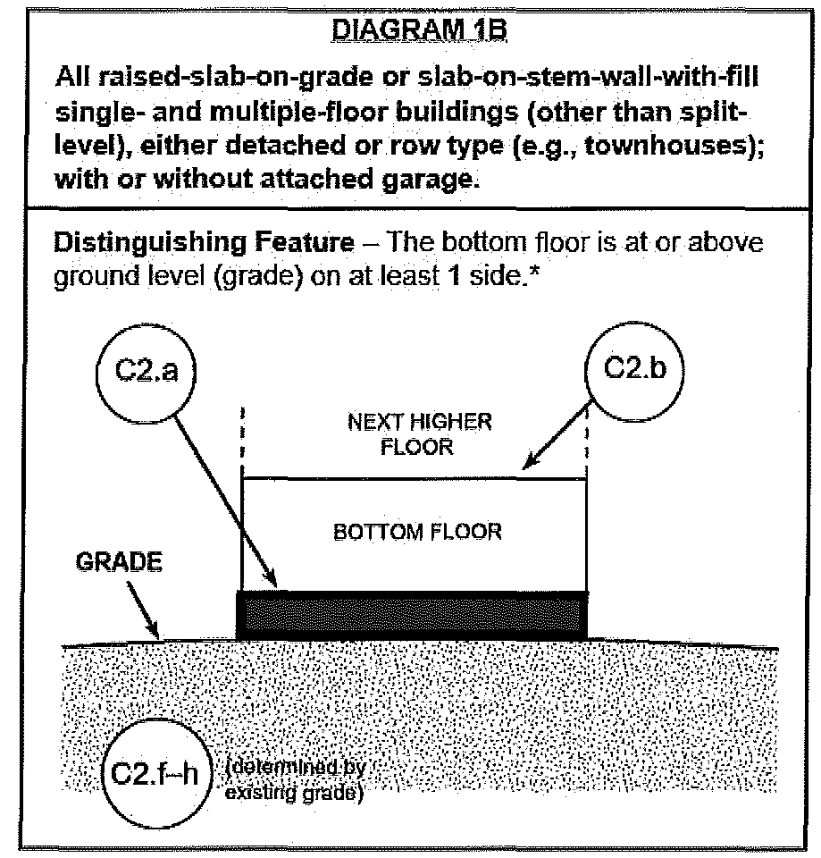
Fill used for structural support in a slab-on-stem wall with fill foundation as depicted in Diagram 1B in Appendix VIII (red area depicts limits of fill) is exempted from the provisions of Subsection 18-5.2(I).
18-5.3
Subdivisions, manufactured home parks and major developments. All subdivision, manufactured home park and major development proposals located within special flood hazard areas shall:
(A)
Be consistent with the need to minimize flood damage;
(B)
Have public utilities and facilities such as sewer, gas, electrical, and water systems located and constructed to minimize flood damage;
(C)
Have adequate drainage provided to reduce exposure to flood hazards; and
(D)
Have base flood elevation (BFE) data provided if development is greater than the lesser of five (5) acres or fifty (50) lots/manufactured home sites. Such base flood elevation (BFE) data shall be adopted by reference per Subsection 18-3.2 to be utilized in implementing this Code.
18-5.4
Standards for floodplains without established base flood elevations. Within the special flood hazard areas established in Subsection 18-3.2, where no base flood elevation (BFE) data has been provided, the following provisions shall apply:
(A)
No encroachments, including fill, new construction, substantial improvements or new development shall be permitted within a distance of twenty (20) feet each side from top of bank or five (5) times the width of the stream whichever is greater, unless certification with supporting technical data by a registered professional engineer is provided demonstrating that such encroachments shall not result in any increase in flood levels during the occurrence of the base flood discharge.
(B)
If Subsection 18-5.3(A) is satisfied and base flood elevation (BFE) data is available from other sources, all new construction and substantial improvements within such areas shall also comply with all applicable provisions of this Ordinance and shall be elevated or floodproofed in accordance with elevations established in accordance with Subsection 18-4.5(K) and (L). When base flood elevation (BFE) data is not available from a federal, state, or other source, the reference level, including basement, shall be elevated at least two (2) feet above the highest adjacent grade.
18-5.5
Standards for floodplains with BFE but without established floodways or nonencroachment areas. Along rivers and streams where base flood elevation (BFE) data is provided but neither floodway nor nonencroachment areas are identified for a special flood hazard area on the FIRM or in the FIS, no encroachments, including fill, new construction, substantial improvements, or other development, shall be permitted unless certification with supporting technical data by a registered professional engineer is provided demonstrating that the cumulative effect of the proposed development, when combined with all other existing and anticipated development, will not increase the water surface elevation of the base flood more than one (1) foot at any point within the community.
18-5.6
Floodways and nonencroachment areas. Located within the special flood hazard areas established in Subsection 18-3.2 are areas designated as floodways or nonencroachment areas. The floodways and nonencroachment areas are extremely hazardous areas due to the velocity of floodwaters that have erosion potential and carry debris and potential projectiles. The following provisions shall apply to all development within such areas:
(A)
No encroachments, including fill, new construction, substantial improvements and other developments shall be permitted unless it has been demonstrated through hydrologic and hydraulic analyses performed in accordance with standard engineering practice that the proposed encroachment would not result in any increase in the flood levels during the occurrence of the base flood. Such certification and technical data shall be presented to the Floodplain Administrator prior to issuance of floodplain development permit.
(B)
If Subsection 18-5.6(A) is satisfied, all development shall comply with all applicable flood hazard reduction provisions of this Ordinance.
(C)
No manufactured homes shall be permitted, except replacement manufactured homes in an existing manufactured home park or subdivision provided the following provisions are met:
(1)
The anchoring and the elevation standards of Subsection 18-5.2(C); and
(2)
The no encroachment standards of Subsection 18-5.6(A) are met.
18-5.7
Coastal high hazard areas (VE and V1—30 zones). Coastal high hazard areas are special flood hazard areas established in Article 3, Section B, [sic] and designated as Zones VE or V1—30. These areas have special flood hazards associated with high velocity waters from surges and, therefore, in addition to meeting all provisions in this Ordinance, the following provisions shall apply to all new construction, substantial improvements and all other development:
(A)
All development shall:
(1)
Be located landward of the reach of mean high tide;
(2)
Be located landward of the first line of stable natural vegetation; and
(3)
Comply with all applicable CAMA setback requirements.
(B)
All development shall be elevated so that the bottom of the lowest supporting horizontal member (excluding pilings or columns) is located no lower than the regulatory flood protection elevation. Floodproofing may not be utilized on any structures in coastal high hazard areas to satisfy the regulatory flood protection elevation requirements.
(C)
All space below the regulatory flood protection elevation shall be open so as not to impede the flow of water.
(D)
Open wood lattice work or mesh insect screening may be permitted below the regulatory flood protection elevation for aesthetic purposes only and must be designed to wash away in the event of abnormal wave action and in accordance with Subsection 18-5.2(D)(2). Design plans shall be submitted in accordance with Subsection 18-4.2(D)(3).
(E)
All development shall be securely anchored on pilings or columns.
(F)
All pilings and columns and the attached structures shall be anchored to resist flotation, collapse, and lateral movement due to the effect of wind and water loads acting simultaneously on all building components.
(G)
A registered professional engineer or architect shall certify that the design, specifications and plans for construction are in compliance with the provisions contained in Subsection 18-4.2, Subsection 18-5.7(D), (F) and (H) of this Ordinance.
(H)
There shall be no fill used as structural support. Noncompacted fill may be used around the perimeter of a building for landscaping/aesthetic purposes provided the fill will wash out from storm surge, thereby rendering the building free of obstruction prior to generating excessive loading forces, ramping effects, or wave deflection. Design plans shall be submitted in accordance with Subsection 18-4.2(D)(3). The Floodplain Administrator may approve design plans for landscaping/aesthetic fill only after the applicant has provided an analysis by an engineer, architect, and/or soil scientist which demonstrates that the following factors have been fully considered:
(1)
Particle composition of fill material does not have a tendency for excessive natural compaction;
(2)
Volume and distribution of fill will not cause wave deflection to adjacent properties; and
(3)
Slope of fill will not cause wave run-up or ramping.
(I)
There shall be no alteration of sand dunes which would increase potential flood damage.
(J)
No manufactured homes shall be permitted except in an existing manufactured home park or subdivision. A replacement manufactured home may be placed on a lot in an existing manufactured home park or subdivision provided the anchoring and elevation standards are in compliance with this section of the Code.
(K)
Recreational vehicles shall be permitted in coastal high hazard areas provided that they meet the recreational vehicle criteria of Subsection 18-5.2(F)(1) and the temporary structure provisions of Subsection 18-5.2(G).
18-6 - Legal Status Provisions
18-6.1
Effect on rights and liabilities under existing flood damage prevention ordinance. This Ordinance in part comes forward by reenactment of some of the provisions of the flood damage prevention ordinance enacted November 10, 1977, as amended, and it is not the intention to repeal but rather to re-enact and continue to enforce without interruption of such existing provisions, so that all rights and liabilities that have accrued thereunder are reserved and may be enforced. The enactment of this Ordinance shall not affect any action, suit or proceeding instituted or pending. All provisions of the flood damage prevention ordinance of Morehead City, North Carolina, enacted on November 10, 1977, as amended, which are not reenacted herein are repealed.
18-6.2
Effect upon outstanding building permits. Nothing herein contained shall require any change in the plans, construction, size or designated use of any development or any part thereof for which a floodplain development permit has been granted by the Floodplain Administrator or his authorized agents before the time of passage of this Ordinance; provided, however, that when construction is not begun under such outstanding permit within a period of six (6) months subsequent to passage of this Ordinance or any revision thereto, construction or use shall be in conformity with the provisions of this Ordinance.
18-6.3
Effective date. This Ordinance shall become effective 12:01 a.m., July 16, 2003.
(Ord. No. 2025-O-04, 1-14-2025)