
Nampa City Zoning Code
CHAPTER 27
- SUBDIVISIONS
Sections:
10-27-1.- General subdivision policy, jurisdiction statement and administrative authority.
A.
Establishment and enforcement. Establishment, interpretation, application and enforcement of the land division regulations found in this chapter by the City of Nampa and its authorized personnel is sanctioned by Idaho Code title 50, chapter 13 and title 67, chapter 65, and article 12, section 2 of the Idaho Constitution, as amended or subsequently codified. These standards or regulations shall apply to all land contained within the limits of the City of Nampa as presently constituted or as may be subsequently incorporated. They also shall apply to the area of city impact per agreement with Canyon County, and shall be in force as allowed according to the City of Nampa and Canyon County's "Joint Exercise of Power Agreement for Area of City Impact," and as each jurisdiction's impact legislation may allow.
B.
Idaho State Code. Idaho State code notes that a division of a tract of land into "five or more lots, parcels, or site for the purpose of sale or building development, whether immediate or future" constitutes a subdivision. Nevertheless, state code allows for individual cities or counties to "adopt their own definition of subdivision" in lieu of the state's.
C.
Subdivision. Nampa has defined a "subdivision" as one that creates three or more lots from an original lot or parcel. No person or party shall subdivide any zoned property that is located wholly or in part in the city after June 11, 2002, into more than two parcels, unless he shall first have made, or cause to have made, a subdivision plat thereof as required by IC title 50, chapter 13, and as set forth within this chapter, save where allowed otherwise in this chapter.
D.
Review and approval. It is unlawful to receive or record any plat or replat within the above boundaries until such plat has been reviewed and approved by the planning and zoning commission and approved by the council, and bears the approval, by signature, of the city engineer, planning and zoning commission chairperson and the city clerk (in addition to the health district's and appropriate county official's signatures).
E.
Administrative authority. Discretionary administrative authority is considered retained by adoption of this legislation. That authority shall permit duly authorized representatives of the City of Nampa Fire, Police, Forestry and Parks Departments to suggest subdivision design changes to the planning and zoning department. That authority shall permit duly authorized representatives of the Nampa planning and zoning department and engineering department to suggest design changes to subdivision plats undergoing review to the city's planning and zoning commission or the city council. The Nampa planning and zoning commission and city council shall carefully consider staff suggestions in their review and approval of plats.
F.
Reference manuals. The following manuals shall be included by this reference:
1.
"Engineering Development and Policy Manual;"
2.
"Standard Construction Specification Manual."
G.
Severability and disclaimer. Where any word, phrase, clause, sentence, paragraph, section or other part of these regulations may be held invalid by a court of competent jurisdiction, such judgment shall only affect that part so held invalid. City (planning and zoning commission or city council) approval of a preliminary or final plat or portion thereof shall not be considered as constituting approval of any engineering or construction drawings, applications or constructs. Such elements require separate city engineering approval.
H.
Common areas. The provision of all residential subdivision common areas along with special amenities such as/including, but not limited to: open space, tot lots, playgrounds, park area, walking path areas, water features, storage areas (e.g., for RVs, buildings that by nature of use and/or design basically equivalent to ministorage type facilities, etc.), pools and clubhouses, etc., by a project developer shall, unless otherwise specifically approved by the city council, be located in common space(s) owned and maintained by a home/property owners' association and shall not be retained in private ownership by a developer.
I.
Covenants, conditions and restrictions. Any covenants, conditions, restrictions (CCR's) that are in conflict with ordinances of this title or conditions of approval issued/ordered/imposed against a property, project, development, subdivision, PUD, MPC or use by the city by virtue of its authority shall be considered invalid by the city insofar as enforcement of the provisions of this title or the conditions of approval are concerned. Correspondingly, provisions, terms, conditions, etc., of CCR's recorded against a property, project, develop-ment, subdivision, PUD, MPC or use in Nampa after receiving land/structure use entitlement from the city shall be drafted to be in harmony with city ordinances or conditions of approval issued/ordered/imposed by the city if the CCR's are to be effective.
J.
Ratio of land uses. Ratio of land uses for subdivisions that are larger than five acres in a mixed use land use designations: In the residential mixed-use land use designation on the future land use map, over 50 percent of the proposed land use shall be residential with no less than five percent of the land use as commercial. In the community mixed-use land use designation on the future land use map, over 50 percent of the proposed land use shall be commercial with no less than five percent of the land use as high-density residential and/or light industrial.
(Ord. No. 4617, section 1(Exh. A), 10-4-2021; Ord. No. 4671, § 1(Exh. A), 5-16-2022; Ord. No. 4702, § 1(Exh. A), 12-5-2022; Ord. No. 4727, § 1(Exh. A), 4-3-2023; Ord. No. 4777, § 1(Exh. A), 12-18-2023)
10-27-2. - Preliminary plat application form, content and process.
A.
Preapplication conference. After development of a concept plan, and prior to submitting a preliminary plat application or having their preliminary plat heard by the planning and zoning commission or city council, a subdivider and/or their engineer may schedule a preapplication conference with the city engineer and planning and zoning director or their designees and other agency officials.
Resubmittal(s) of plats to the planning office prior to planning and zoning commission review in a public hearing forum may necessitate rescheduling and possibly readvertising of those plats.
B.
Application. Every person seeking to subdivide land shall file with the planning and zoning director appropriate application materials including a completed subdivision application package including a PDF copy of the concept plan and preliminary plat (with supporting data as required in this section) together with requisite review fees shall also be concurrently submitted. Additionally, a copy of the preliminary plat(s) shall be submitted in AutoCAD format, version 17 or higher. An application for a proposed plat must be accompanied by written consent from all property owners whose land(s) are to be made a part of the plat. Any application to re-plat a subdivision's common areas shall also require the consent of the HOA board of said subdivision (if the HOA is active and on file with the Idaho Secretary of State).
1.
Form of Presentation. The information hereinafter required as part of the preliminary submittal shall be shown graphically or by note on plans or by letter and may comprise several sheets showing various elements or required data. All mapped data for the same plat shall be drawn at the same standard engineering scale, having a minimum scale of no more than one inch equals 100 feet.
2.
Contents of Map. The preliminary plat map prepared by the subdivider and filed with the planning and zoning director or his designee shall contain the following:
a.
Proposed name of subdivision and its location by section, township and range, reference by dimension and bearing to a section corner or quarter section corner. Subdivision names shall be sufficiently distinct from each other to avoid confusion or duplication. Subdivision names shall not be duplicative with any other plat name found in the city or Canyon County.
b.
Name, address and phone number of subdivider and engineer, surveyor, landscape architect, and/or landscape designer that contributed to preparing the plat.
c.
Scale, north point and date of preparation including dates of any subsequent revisions.
d.
An initial, preliminary landscape plan for the development that shows, as a minimum, proposed tree locations, calipers and species along with any known overhead or belowground power line easements, and any special landscaping or landscape areas shall be included in the development. The landscape plan shall be crafted in accordance with provisions in this chapter and prepared by a landscape architect. Short plat landscape plans may be prepared by a landscape designer or land planner.
e.
Topography shown in the same map as the proposed subdivision layout. Contour interval shall reflect the character and drainage of the land.
f.
Location of water wells, streams, canals, irrigation laterals, private ditches, washes, lakes or other water features, direction of flow, and location and extent of known FEMA floodway, floodplain and other areas subject to inundation.
g.
The approximate location of existing sanitary sewers, septic systems, leach fields, storm drains, pressure irrigation main and domestic water supply mains within the tract and within 500 feet adjacent thereto.
h.
The location, widths and other pertinent dimensions of existing or platted streets and other important features such as railroad lines, watercourses, easements of public record, permanent structures to remain and exceptional topography within and contiguous to the tract to be subdivided.
i.
Boundaries of the tract to be subdivided shall show approximate dimensions and acreage.
j.
Name, book and page numbers of any recorded adjacent subdivision having common boundary with the tract.
k.
The location, widths and other pertinent dimensions of proposed streets, curbs, alleys, pathways, sidewalks, subdivision fencing, utility easements, storm drainage easements, and right-of-way.
l.
All portions of property intended to be dedicated for public use or reserved for the use of all property owners with the purpose and method of maintenance indicated and all proposed easements.
m.
Typical lot dimensions to scale; approximate dimensions of all corner lots and lots of curvilinear sections of streets; proposed lot and block numbers; total number of lots; and individual lot square footage and individual lot, nonstandard utility, waterway, easement (i.e., power lines) square footages. Individual lot square footage shall be written upon each lot and listed in a separate table upon the face of the preliminary plat.
n.
The proposed names of all the streets whether new or continuous. Street names shall be sufficiently distinct from each other to avoid confusion or duplication.
o.
By note, the existing zoning classification of the tract and any requested zoning changes.
p.
Appropriate information that sufficiently details the proposed development within any special development area, such as hillside, planned unit development, floodplain, cemetery, mobile home, large scale development, hazardous and unique areas of development.
q.
A statement describing the proposed irrigation source shall appear on the preliminary plat. The delivery of water shall be executed in accordance with Idaho code section 31-3805. The statement shall be accompanied by proof of transferable irrigation water rights.
r.
The proposed method of handling sanitary sewage, stormwater, irrigation and potable water within the tract and any offsite improvements if required including a preliminary layout for sewer, water and storm drainage systems/flows.
Sealed engineering calculations are required to substantiate the proposed methods and document the impacts to the city water, sewage, irrigation, and stormwater system(s). Engineering calculations are also required for individual and/or private water, sewer, irrigation, and stormwater system(s).
s.
Any proposed private streets or accessway shall be identified.
t.
All utilities shall be underground including power at distribution voltage.
u.
All requested variances to the subdivision, zoning, comprehensive plan or other city ordinance shall be identified by notes on the plat.
3.
Separate information needed. The preliminary plat map submittal shall be further accompanied by the following information that may be on separate sheets or in letter form:
(a)
Proof of property interest, which may include a warranty deed or affidavit of proprietary interest.
(b)
If the proposed subdivision is part of a larger area intended for development, a development master plan of the entire area.
(c)
Elevations of proposed structures indicating architectural treatments, roof pitch, styling, colors, siding, cladding, and special features.
(d)
An initial, preliminary landscape plan for the development that shows, as a minimum, proposed tree locations, calipers and species along with any known overhead or belowground power line easements, and any special landscaping or landscape areas shall be included in the development. The landscape plan shall be crafted in accordance with provisions in this chapter and prepared by a landscape architect. Short plat landscape plans may be prepared by an Idaho registered landscape architect or professional landscape designer.
(e)
An "Open Space Plan" illustrating the following:
i.
Qualified open space locations and elements provided within. The size of each qualified open space area (expressed in square feet and acres) and the total area of qualified open space (expressed in acres and expressed as a percentage of the gross buildable area) shall be indicated on the plan.
ii.
Common open space locations. The size of each common open space area (expressed in square feet and acres) and the total area of common open space (expressed in acres) shall be indicated on the plan.
iii.
Conceptual drawing/renderings/pictures of the recreational elements, natural features and structures shall be included.
(f)
Such evidence, data or calculations (e.g., including, but not limited to, traffic impact, soils, hydrological, stormwater, environmental studies) shall be furnished as required by the city's current design policy, stormwater policy, as included in the manuals referenced in subsection 10-27-1.F of this chapter, or any other local, state, or federal requirements or as required by the city engineer to evaluate the proposed facilities or their impact upon existing facilities.
(g)
When individual sewage disposal systems are proposed, a feasibility study shall be furnished which shall be a copy of that submitted to the Southwest District Health department.
(h)
Appropriate fees.
(i)
If the proposed development contains private streets, water, sewer or irrigation facilities, the developer shall submit to the city a written description outlining, at least, the following:
(i)
Method of construction inspection.
(ii)
Method of maintenance.
(iii)
Financial arrangements for providing maintenance and future replacement of the facility(ies) following expiration of its (their) useful life (lives).
C.
Neighborhood meeting. A neighborhood meeting shall be conducted as outlined in section 10-2-2.B, Planning application neighborhood meeting of this title.
D.
Review. The planning and zoning director or his designee shall transmit a copy of the application and preliminary plat to the city departments and such other agencies that have jurisdiction or any interest in the proposed subdivision for their review and recommendation. If no reply is received within 30 calendar days from the date of notification, approval of the preliminary plat by such department or agency will be considered to be granted unless after public hearings are conducted on the application, changes to the proposal warrant additional conditions from departments: Note: Changes to the application may warrant further comment or conditions.
E.
Public hearing requirement. All subdivisions shall have/require a public hearing prior to approval of the preliminary plat.
F.
Notification requirement(s). The city shall advertise forthcoming public hearings on preliminary plats. Advertisement of such hearings shall be executed according to the following criteria:
1.
At least 15 calendar days prior to a preliminary plat hearing, notice of the time and place of said hearing, together with a summary of the plat proposal, shall be published in an official newspaper of local circulation.
2.
Notice(s) of the hearing shall also be posted on the general premises of the subdivision site, alongside and visible from one or more abutting rights-of-way and/or properties at least one week prior to the hearing.
3.
Mailed notifications shall also be sent to area property owners or purchasers of record having property that lies within 300 feet of the external boundaries of the land being considered for subdivision.
4.
Any additional area that may be substantially impacted by the proposed subdivision, as determined by the planning director, should be notified by issuance of mailed notices or extra posting of the property, as appropriate.
5.
When mailed notices are required to be given to 200 or more property owners or purchasers of record, an alternative form of procedure for providing official notice may be utilized. In lieu of distributing mailed notices, two additional newspaper notices shall be posted in an official newspaper of local circulation for two consecutive days.
6.
Failure to notify every affected property owner of an upcoming plat review via public hearing shall not be considered sufficient cause to render the review process or hearing invalid provided substantial mailed notification has been otherwise provided to area property owners, unless otherwise determined by a court of law.
G.
Planning and zoning commission action. Within 60 calendar days following receipt of preliminary plat submittal materials, said preliminary plat application shall be placed on the planning and zoning commission's agenda for review as a public hearing item. The planning and zoning commission shall approve, conditionally approve, table, or disapprove the preliminary plat within 30 calendar days after the public hearing is closed, unless all concerned agree upon an extension of time. Plats shall be eligible for approval if all requisite/needed application/submittal materials have been received by the city, the proposed plat design complies with relevant zoning and subdivision standards, and engineering attests that provision of services to the future development is available.
The planning and zoning commission shall evaluate a proposed plat's design based on city codes in making its determination(s). The reasons for such action by the planning and zoning commission together with any conditions of approval shall be stated in writing, a copy of which shall be sent to the subdivider. Any appeals of the planning and zoning commission's decision shall be filed and processed in accordance with provisions listed in section 10-27-5 of this chapter.
When a preliminary plat application is submitted concurrently with an application for annexation or an application for a zoning map amendment, city council shall evaluate both applications following recommendations from the planning and zoning commission. City council shall approve, conditionally approve, table, or disapprove each application.
At least one copy of an approved preliminary plat will be kept on file for public examination in the planning and zoning department. Approval of a preliminary plat shall be valid for a period of 540 calendar days (approximately 18 months), unless an extension of time is applied for and granted by the planning and zoning commission prior to lapse of the approval period. The commission may grant extensions for one-year increments up to three extensions may be requested.
Once a final plat to divide property is approved, recorded and its associated construction drawings have been approved by the city engineer for an area of land, or portion thereof, previously approved via a related preliminary plat, that preliminary plat is then considered "vested" or valid and "in force" indefinitely.
Once a final plat is recorded, it shall be valid until replatted and/or vacated.
H.
Revised preliminary plat submittal. Following approval of any preliminary plat by the planning and zoning commission or council, the developer or his/her engineer shall cause to be made and submitted to the city one or more copies as may be required by the city of the revised preliminary plat. Such plat shall contain all modifications/revisions/corrections required by the city. The revised plan shall be reviewed by the city and when deemed acceptable, shall be approved. After the revised preliminary plat is approved, city council may then take action on any related and subsequent final plat request for the same project.
I.
City council action; design or other exceptions. Whenever a tract to be subdivided is of such unusual shape or size or is surrounded by such development or features unusual conditions such that the strict application of city subdivision requirements would expectedly result in real difficulties or substandard design, or could be improved upon or altered by another, perhaps even superior design, the council may vary or modify subdivision platting requirements. The fact that an owner could realize a greater financial return from his property by subdividing said property contrary to these regulations is not sufficient reason for approval of the exception. (In other words, it is the intent of this subsection to allow a developer to divide property in a reasonable manner, but at the same time, protect the public welfare and interests of the city and surrounding area and preserve the general intent and spirit of this chapter.)
The council may also approve exceptions to subdivision standards for a plat processed as a PUD and MPC, as detailed in section 10-27-4 of this chapter.
Subdivision proposals meeting any of the following criteria below shall be required to obtain city council approval, via business item review of the preliminary plat, prior to the preparation and submission of a final plat to the city's planning and zoning commission:
1.
Subdivision(s) proposing to not use city water, sewer storm drainage or irrigation service(s).
2.
Subdivision(s) not anticipated/proposed to fully conform to city subdivision or zoning ordinance design and dimensional standards.
(Ord. No. 4617, § 1(Exh. A), 10-4-2021; Ord. No. 4671, § 1(Exh. A), 5-16-2022; Ord. No. 4702, § 1(Exh. A), 12-5-2022; Ord. No. 4727, § 1(Exh. A), 4-3-2023; Ord. No. 4777, § 1(Exh. A), 12-18-2023)
10-27-3. - Final plat application form, content and process.
After approval (or conditional approval) of a preliminary plat, the subdivider may cause the subdivision, or any part thereof, to be surveyed and a final plat prepared in accordance with the preliminary plat as approved. The subdivider shall file with the planning and zoning department requisite final plat application materials as hereafter denoted:
A.
Form of presentation.
1.
A completed subdivision application form and PDF copy of the following:
a.
Final plat with an indication of the square footage of each and every proposed lot 1.
b.
Construction drawings.
c.
A legal description of each phase proposed for final review.
d.
A landscape plan.
2.
The plat shall be so drawn that the top of the drawing faces generally north. All lines, dimensions and markings shall be made on the plat in accordance with provisions of Idaho Code. The actual map shall be made on a scale of no less than 100 feet to the inch and shall clearly show all details.
3.
The final plat drawings and plans for subdivisions proposed in the city its impact area shall be submitted in digital form and to a datum approved as specified in the manuals referenced in subsection 10-27-1.F of this chapter. This will assist with the updating of the city "base maps," record drawings, and addressing.
4.
Requisite fees.
B.
Contents. The following information shall be contained upon the final plat to be filed:
1.
The name and general location of the subdivision in bold letters at the top of the sheet. (The name of the subdivision must not bear the name of any town or plat in Canyon County.)
2.
North arrow and scale of the plat.
3.
Name, address and official seal of the registered land surveyor preparing the plat.
4.
The boundaries must be accurately drawn showing the proper bearings and dimensions of all boundary lines of the subdivision and where possible the bearings and coordinate system for the plat shall be on the Idaho state modified coordinate system. These lines should be heavier than street and lot lines.
5.
Boundaries of the tract to be subdivided fully balanced and closed, showing all bearings and distances determined by an accurate survey in the field. All dimensions, both linear and angular, are to be staked in the field by accurate control survey, which must balance and close within a limit of one in 10,000. If staking is to be provided after the recording of the plat, the subdivider shall meet all requirements established by Idaho Code title 50, chapter 13.
6.
The names, widths, lengths, bearings, curve data on centerlines of proposed streets, alleys and easements desired or necessary; the boundaries, bearings and dimensions of all parcels within the subdivision intended to be dedicated to the use of the public; and the sizes, lines, dimensions, curve data and number of all lots, blocks and/or parts reserved or excepted for any reason within the subdivision.
7.
The widths of abutting streets and alleys, and their names (if they have any), the names and boundaries of all subdivisions which have been previously recorded and are adjacent thereto, must be shown upon the plat offered for record. These adjacent subdivisions shall be shown as dotted lines to show their relationship to the plat offered for record. If adjoining land is unplatted it should be indicated as such.
8.
All linear dimensions shall be calculated to the nearest 0.01 of a foot and all bearings shall be calculated to the nearest ten seconds of arc. All curves shall be defined by the radius, central angle, tangent, arc, chord distances and chord bearings. The description and location of all monuments shall be shown. Monuments shall be set in accordance with Idaho Code title 50, section 13.
9.
All lots and blocks shall be numbered throughout the plat in accordance with Idaho Code.
10.
Any excepted parcels within the plat boundaries shall show all bearings and distances, determined by an accurate survey in the field.
11.
Location and description of cardinal points to which all dimensions, angles, bearings and similar data on the plat shall be referenced. In addition to the requirements of Idaho Code title 50, chapter 13, the exterior boundary of the subdivision shall be tied to not less than two recognized county or city survey monuments.
12.
The datum utilized for the final plat and construction drawings shall be stated on both the final plat and construction drawings.
13.
The required forms shall be lettered on the plat for the following: registered land surveyor's "certificate of survey;" owner's dedication certificate with notary public acknowledgment; the approval of the mayor and council as attested by the clerk; approval by the city engineer; approval by the planning and zoning commission; and other certificates as required by Idaho code.
C.
Additional materials. The final plat submittal shall also be accompanied by the following:
1.
Private restrictions. Copies of any private restrictions and/or covenants proposed to be recorded for the purpose of providing regulations governing the use, building lines, open spaces or other aspects of development and use. This includes, but is not limited to, all easements to be recorded as part of and/or intended to service the development.
2.
Lot area. Submittals shall include areas of all lots. Lots and density for a standard subdivision shall adhere to the following lot size and density requirements:
Base lot: The cumulative area of the parcel(s) where the multi-unit structure resides. When developing townhouses the base lot shall be a lot size within the minimum and maximum range on the chart. From this proposed base lot the townhouse units can be subdivided according to the product type to provide single-family housing units.
a.
Buildable lot size and density requirements. New lots created on or after October 4, 2021 by an administrative lot split or through a subdivision of the land must conform to the minimum and maximum lot size and density requirements established for the zoning district assigned to that parcel in order to be considered a 'buildable' lot.
3.
Water and sewer facilities design. Design approval by the appropriate health agency, if other than the city, of the proposed water and sewer facilities.
4.
Improvement drawings. Construction drawings and specifications prepared by a properly licensed engineer with details rendered in conformance with the manuals referenced in subsection 10-27-1.F of this chapter. A general utility sheet showing all utilities combined (i.e., sewer, water, storm drainage, street lighting, etc.) shall be included in the set.
5.
Landscape plan. See NCC 10-33-2.H.4 and 5 for landscape plan set and open space plan requirements.
a.
A copy of the landscape plan and open space plan (drawn in accordance with regulations contained in chapter 33 of this title), as submitted to the city's planning and zoning department, shall be included in the improvement drawings package.
6.
General. The drawings shall include sufficient, accurate topographic detailing of adjacent properties and roadway to adequately depict or address impact of the development (e.g., span 50 feet beyond edge of properties' boundaries). All locations of regulatory signs, as classified by the "Manual on Uniform Traffic Control Devices" (MUTCD), shall be shown on the roadway plan sheets included as a part of the improvement drawings.
7.
Ownership and maintenance agreement. Ownership and maintenance agreement for all common areas, access easements or areas of joint ownership.
D.
Final plat review and approval procedures.
1.
The final plat, after having been prepared in accordance with Idaho Code requirements and the provisions set forth herein, shall be submitted to the planning and zoning director or his designee within 18 months after approval of the preliminary plat, unless a time extension has been granted by the planning commission.
2.
Final plat submission shall be made to the planning and zoning director or his designee for his review at least 41 calendar days before the planning and zoning commission meeting at which the plat is to be considered. The planning and zoning commission shall act on the application for final plat approval as a business item on its agenda within 30 calendar days from the first meeting at which the final plat was formally presented unless all concerned agree upon an extension of time.
3.
The planning and zoning director or his designee shall transmit one copy of the final plat and/or improvement drawing(s) for review by departments and agencies, or others as may be deemed necessary to ensure compliance with the approved preliminary plat. If no replies and/or preliminary staff reports are received from any of the various departments or interested agencies within 30 calendar days from the date of transmittal, approval of the final plat by such department or agency shall be considered granted.
4.
In the event the final plat does not substantially conform to the approved preliminary plat based on considerations listed in section 10-27-2 of this chapter, the planning and zoning director or his designee shall so inform the subdivider and proceed to assign the final plat to the planning and zoning commission agenda for its consideration of the plat as a revised/amended or new preliminary plat, as deemed most appropriate.
5.
The Planning and zoning commission may consider a final plat for approval, along with the improvement drawings associated with said plat. In all cases the city council reserves the right to impose or sustain any reasonable condition it so deems necessary.
6.
Notice of the approval or disapproval of the planning and zoning commission along with any other pertinent comments and/or recommended conditions shall be submitted in writing to the subdivider and to the mayor and council. If approved, the final plat shall have endorsed thereon the required approvals.
The council shall review the plat and consider the planning and zoning commission's recommendations at the next available city council meeting. If approved, the final plat shall have endorsed thereon the required approvals. If the council, however, receives the final plat for review because of an appeal being filed on said plat, the council shall decide whether to approve the plat. In all cases the city council reserves the right to impose or sustain any reasonable condition it so deems necessary.
7.
At the time of approval and contingent upon the recording of the final plat, the city shall accept the dedications shown thereon.
8.
Upon final approval and obtaining all required signatures the subdivider shall take the final plat to the county recorder for recording. One reproducible copy, in mylar, of the plat must be prepared and filed with the city engineering division. The county recorder shall have attested the content on the reproducible copy to be the same that has been recorded with the county. The first final plat of a subdivision development shall be filed with the county recorder within 12 months after approval of the council to vest an approved preliminary plat, otherwise such approval shall become null and void unless an extension of time is applied for and granted. The commission may grant one year extensions for the first final plat of a subdivision development. Up to three extensions may be requested. Once a preliminary plat is vested by the first phase, no other final plat extensions shall be required.
(Ord. No. 4617, § 1(Exh. A), 10-4-2021; Ord. No. 4671, § 1(Exh. A), 5-16-2022; Ord. No. 4702, § 1(Exh. A), 12-5-2022; Ord. No. 4727, § 1(Exh. A), 4-3-2023; Ord. No. 4777, § 1(Exh. A), 12-18-2023; Ord. No. 4873, § 17, 6-16-2025)
10-27-4. - Special subdivisions and developments.
A.
Planned unit developments, master planned communities, condominiums, townhouses, urban neotraditional, and other "special" developments.
1.
Planned unit developments. See chapter 26 of this title for a detailed list of submittal requirements and guidelines.
2.
Master planned communities. See chapter 26 of this title for a detailed list of submittal requirements and guidelines.
3.
Condominiums. Condominiums shall be created/executed via IC title 55, chapter 15 and shall be placed on the city council agenda as a consent item after review by the city's planning and zoning department and engineering division for compliance/completeness.
4.
Townhouses.
a.
In the RS zone townhouses are allowed only through a CUP if the parcel gross acreage is less than two acres, and only a PUD if the parcel gross acreage is two acres or larger.
b.
In an RS PUD the minimum lot size per each two-unit townhouse shall be at least one-half that normally required in the RS zone within which the residential structure is proposed. (For example, the minimum lot size for one unit of a two-unit townhouse in an RS6 Zone PUD shall be 3,000 square feet according to that standard.)
c.
Townhouse developments require a preliminary and final plat. All preliminary plats are subject to the review and approval process outlined in chapter 27, sections 2 and 3 of this title.
d.
Front, side and rear yard setbacks, bulk requirements and height limitations pertaining to townhouse lot(s) and buildings, shall be per pertinent district standards.
5.
Cluster housing development. See chapter 26 of this title for a detailed list of submittal requirements and guidelines.
6.
Additional general provisions. The city council may further approve reductions in required setbacks for special developments during review of a plat wherein the units will be located. In such cases, the following conditions shall apply:
a.
In no case shall garages or carports be allowed closer than 20 feet to the property line adjacent to the street giving access to a lot, although, the living space (non-parking) part of the home may be within 15 feet of the front property line and ten feet from the street side property line on a corner lot.
b.
If the council approves reduced setbacks in the plat review stage, then building envelopes reflecting council's allowances shall be depicted on the final plat.
c.
Any "developer proposed" building envelopes be depicted on preliminary plats where possible, and as noted above, if approved, be likewise noted on final plats (or portions of final plats where the provision for dwelling units was made).
d.
Any setback area waived via de facto variance approval given by the council during plat review be transferred to another part of the plat in equal measure. Such space shall be made into usable open space dedicated for use by "special" development lots in the subdivision.
B.
Subdivision within a 100-year floodplain. For any proposed subdivision that is located within or has part of its development proposed within a 100-year floodplain area, the subdivider shall provide the planning and zoning commission, as part of the normal preliminary plat application submittal, a development plan of adequate scale that provides documentation that will show and explain at least the following:
1.
Location of all planned improvements.
2.
The location of floodways and the floodway fringe in accordance with sound engineering practices.
3.
The location of the present water channel.
4.
Any planned rerouting of waterways.
5.
All major drainageways.
6.
Areas of frequent flooding.
7.
Means of floodproofing buildings.
8.
The lowest floor (including basement) of any residential structure shall be elevated to at least one foot above the 100-year flood line.
9.
No subdivision or part thereof shall be approved if levees, fills, structures or other features within the proposed subdivision will individually or collectively significantly increase flood flows, heights or damages.
10.
Upon determination that buildings are planned within the floodplain or that alterations of any kind are anticipated within the floodplain area that will alter the flow of water, the subdivider shall demonstrate conclusively that such development will not present a hazard to life, limb, or property, adverse effects on the safety, use or stability of a public way or drainage channel and not have an adverse impact on the natural environment or public utilities. Floodproofing plans must be (individually) approved by the planning and zoning commission.
11.
If only part of a proposed subdivision can be safely developed, development shall be limited to that part.
C.
Subdivision for a cemetery or columbarium. Property or structure which shall be used as a cemetery or columbarium shall be required to be platted. Private cemeteries will require a letter from an attorney that defines manner of management of the cemetery or columbarium (as well as whether they are to be used for human or animal remains) shall accompany plat submittal plans and fees.
1.
Process. Owner/developer of a cemetery shall submit application for a short plat to the Nampa Planning Department with a review fee. The short plat application will be reviewed and approved by the planning director or his/her designee.
Upon approval from the planning and zoning director or his/her designee, the final plat portion of the application will be scheduled as a consent item for city council to authorize the city clerk to sign the final plat.
2.
Contents. The plat shall include the following as part of the submittal and in accordance with IC § 50-1304:
a.
The streets and alleys, with widths and courses clearly shown.
b.
Each street name (external and internal).
c.
All lots number consecutively in each block, and each block lettered or numbered, provided however, in a platted cemetery, each block, section, district or division and each burial lot shall be designated by number or letter or name.
d.
Owner sheet with legal description.
e.
Signature page requires all signatures for agencies involved in the review of the approved development.
D.
Areas of critical concern.
1.
Special consideration. The development of any hazardous or unique areas that have been previously designated as areas of critical concern by the planning and zoning commission as provided by Idaho Code shall demand that special consideration be given by the subdivider to assure that the development is necessary and desirable and in the public interest in view of the existing unique conditions. The planning and zoning commission may, through due process, designate an area as hazardous or unique if one or more of the following conditions are present:
a.
Unstable soils or slopes;
b.
Unique animal, wildlife, or plant life habitat;
c.
Particular or unique scenic value;
d.
Historical significance;
e.
Floodplains;
f.
High ground water elevation;
g.
Hazardous environmental conditions, either surface or subsurface; or
h.
Other conditions which may be determined by the Planning and Zoning Commission to be unique or of critical concern.
(2)
Plan submission. The subdivider shall prepare and submit an environmental assessment (and mass grading and drainage plan if called for by city engineering) for those areas of critical concern as above noted along with the preliminary plat application materials.
(3)
Content of environmental assessment. The content of the environmental assessment expectedly shall be prepared by a team of professionals that will provide answers to the following questions:
a.
What environmental impacts will probably occur (i.e., wildlife, plant life, social, economic, physical, etc.) as a result of the proposed development?
b.
What corrective action or alternative plans could be developed so as not to significantly cause detrimental environmental impact?
c.
What adverse effects of the proposed development cannot be avoided?
d.
Review comments and correspondence from appropriate regulatory agencies shall be submitted to the engineering department.
E.
Exceptions. The platting requirement and regulations governing for platting contained within this chapter shall not apply to any of the following:
1.
A readjustment of property lines of a non-common lot as shown on a recorded final plat or established via a survey which does not reduce the area, frontage, width or depth of each building lot/parcel below the minimum prescribed by applicable zoning standards. In the case of a readjustment, a record of survey that conforms to Idaho Code title 55, chapter 19 shall be required. The following shall be included on the record of survey:
a.
The original plat lot or parcel line(s) involved in the request.
b.
The proposed location(s) of the altered line(s).
c.
The square footage of the adjusted lots, correct street names, positions of all existing buildings, a note giving the zone standard in effect for the area or as specifically approved.
d.
Depiction of all existing easements of record pertinent to the property(ies) involved and any newly proposed easements.
e.
Certification and acknowledgment of the owners of property involved in the request together with a copy of the surveyor's Idaho State certification or with an imprint of the surveyor's seal or stamp witnessing that they are licensed in Idaho.
f.
Certification that no utility lines exist within an easement that will be affected by the lot line and easement adjustment.
g.
Any recorded easements needing to be vacated be so vacated, by official action via public hearing review and vote of the city council.
2.
One division of any original lot or parcel of land (after June 14, 1977, in the city's impact area or June 11, 2002, if in the city proper, as appropriate) into not more than two lots or parcels may be done, provided that each building lot or parcel resulting from such a split meets applicable zoning standards in order to be considered by the city as "buildable" property. Any subsequent divisions will require filing for subdivision plat approval.
In the matter of a simple division of a platted lot or non-platted parcel that does not involve a change to a recorded public right-of-way or easement, the person desiring the division may execute the division via a metes and bounds description provided the description will close, does not change or interfere with recorded rights-of-way or easements (public or private) and does/will not conflict with contiguous property boundaries. Said description may need to be written by a professional land surveyor, attorney, real estate broker, title company or civil engineer. (However, note that a survey will still be required for the property when and if an application for a building permit for a structure is later submitted for those new properties.)
3.
Divisions occurring as a result of condemnation.
4.
A division of land in the settlement of an estate or as part of and subject to a court ordered property distribution and layout.
5.
A reduction in the number of lots (executed by a "density reduction survey") which does not otherwise violate any city ordinance(s).
6.
A division into parcels greater than five acres in size that does not require any new street dedications.
7.
A split of a lot or parcel annexed from Canyon County into two parcels (even if a previous lot split had occurred prior to annexation and after June 14, 1977), provided that each building lot or parcel resulting from such a split meets applicable zoning standards in order to be considered by the city as "buildable" property.
8.
A one-time split of a subdivision lot into two parcels, provided that each building lot or parcel resulting from such a split meets applicable zoning standards in order to be considered by the city as "buildable" property.
F.
Short plats. Proposed land divisions wherein either it is proposed to create three (3) properties or more from a parent lot or parcel, or, wherein a simple property split is no longer deemed to be available to a property may be executed by filing for a short plat permit in accordance with the following standards:
1.
A neighborhood meeting shall be conducted as outlined in section 10-2-2.B, Planning application neighborhood meeting, of this title.
2.
The short plat shall be for no more than seven building lots (partitioned from an original lot or parcel) or eight individual (derived from four "master" townhouse lots); and
3.
Short plats proposed/developed in RS6 or RS7 zones shall be exempt from the lot compatibility (averaging and periphery check) requirements (found in subsection 10-27-6.F of this chapter) associated with those zones; and,
4.
A short plat's drawings shall portray all features required to be shown on standard preliminary and final plat drawings; and short plats will be processed as combination preliminary and final plats requiring a public hearing before the city's planning and zoning commission and approval by the city council. The time frame for review and processing of short plats shall be the same as for standard preliminary plats. Short plat approvals shall be valid for 18 months.
5.
Short plats are exempt from open space requirements.
(Ord. No. 4617, § 1(Exh. A), 10-4-2021; Ord. No. 4671, § 1(Exh. A), 5-16-2022; Ord. No. 4702, § 1(Exh. A), 12-5-2022; Ord. No. 4727, § 1(Exh. A), 4-3-2023; Ord. No. 4809, § 1(Exh. A), 6-3-2024; Ord. No. 4873, § 17, 6-16-2025)
10-27-5. - Appeals of actions on plats.
An appeal may be made to the city council of the planning and zoning commission's decision to approve, approve with conditions or deny a proposed preliminary plat as follows:
A.
Any aggrieved person or party whose preliminary plat has been denied or approved with conditions unacceptable to that developer may appeal to the mayor and city council for a hearing to review the action of the planning and zoning commission. The planning and zoning director or his/her designee must receive any such appeal within 15 days (by 5:00 p.m. on the fifteenth day) starting on the day following the planning and zoning commission's action in order to schedule an appeal hearing. A public hearing shall be scheduled before the city council. The council hearing shall be regarded as de novo and, therefore, not limited only to consideration of evidence presented to the planning and zoning commission.
B.
Any aggrieved person residing or owning property within an area affected by a proposed subdivision may appeal to the mayor and council for a hearing to review the action of the planning and zoning commission. The planning and zoning director or his/her designee must receive such an appeal within 15 days (by 5:00 p.m. on the fifteenth day) starting on the day following the planning and zoning commission's action in order to schedule an appeal hearing in front of the city council. The council hearing shall be regarded as de novo and, therefore, not limited only to consideration of evidence presented to the planning and zoning commission.
C.
The city engineer or planning and zoning department director may appeal to the city council a preliminary plat decision made by the city's planning and zoning commission. The planning and zoning director must file such an appeal within 15 days (by 5:00 p.m. on the fifteenth day) starting on the day following the commission's action in order for the appeal to be considered valid. If properly filed, the appeal shall then be heard as an advertised public hearing before the city council. The hearing shall be regarded as de novo and, therefore, not limited only to consideration of evidence/information originally presented to the planning and zoning commission.
(Ord. No. 4617, § 1(Exh. A), 10-4-2021)
10-27-6. - General development and improvements; requirements.
In order to be approved, subdivisions shall conform to the city's adopted zoning laws, the referenced manuals in subsection 10-27-1.F of this chapter, stormwater policy, and other relevant ordinances and regulations of the city.
The owner or subdivider of a subdivision development shall be responsible to construct or cause to be constructed, in accordance with city standards, certain minimum improvements for any subdivision as listed in the manuals referenced in subsection 10-27-1.F of this chapter. All required permits are the responsibility of the owner and/or subdivider. Said improvements shall be emplaced within, completely along, and through the development (property). The improvements described in this section shall be shown on the construction drawings of any subdivision and installed in accordance with the procedures and requirements hereinafter designated.
Land which the planning and zoning commission determines to be unsuitable for subdivision because of periodic flooding, poor drainage, excessively steep slopes or other features likely to be harmful to the safety, health and welfare of future residents, shall not be subdivided unless adequate methods as approved by the city engineer are utilized to overcome these conditions.
A.
Street requirements. Arterial and collector streets shall be dedicated to the public in all cases. All other streets shall also be dedicated to the public use except under special circumstances, private streets may be allowed. All proposed, platted subdivisions shall comply with the street design specifications contained hereinafter and in the manuals referenced in subsection 10-27-1.F of this chapter. All collector and arterial street frontages as well as local roads shall be required to have vertical, rolled, or ribbon curbing, gutter, sidewalk, bio swale, landscaping and paving improvements as required by the manuals referenced in subsection 10-27-1.F of this chapter. Both planning and engineering staff may recommend future street locations, extensions and connections for areas not specifically mapped by the city's street master plan. Additionally, all lots/parcels developed/"built out," or proposed to be developed/"built out," with structures thereon shall have, or be demonstrated to have, legal access to a public street (this will have to occur before the city will sign a plat when reviewing a newly proposed subdivision or otherwise will have to occur before the city will/may issue or approve construction of any structures on that lot/parcel, as iterated in the definition of "property" in section 10-1-2, "Definitions," and subsection 10-1-7.B.1 of this title).
1.
Subdivisions with private streets; other requirements. Subdivisions with private streets shall be processed in the same manner as subdivisions with public streets, subject to the following conditions:
a.
Provision should be made for the future operation and maintenance of the private roadways in the proposed development since the city will not maintain the roadways. Prior to the city accepting the roadways as public and maintaining them, they may have to be upgraded to city public street standards. A local improvement district (LID) may be imposed by the city on those owners/users of the street(s) to pay for and execute the upgrade(s) prior to the city accepting it. Notification of this requirement shall be noted on the plat.
b.
The street(s) in the subdivision meets all applicable public road construction standards as detailed in the manuals referenced in subsection 10-27-1.F of this chapter.
c.
Within the impact area the council may recommend to the county that the standard improvement requirements for a subdivision (e.g., curb, gutter and sidewalk, streetlights, landscaping, street widths and paving, pressure irrigation, sewer, water) be waived.
2.
Subdivisions with public streets; requirements. Subdivisions with public streets shall be reviewed in accordance with standards contained hereinafter and within the manuals referenced in subsection 10-27-1.F of this chapter.
a.
City transportation plan. All streets in the subdivision must conform to the master transportation plan of the city and any adopted neighborhood street plans. Where a subdivision abuts or contains an existing or proposed arterial street or railroad, the planning and zoning commission may require marginal access streets, reverse frontage with screen planting contained in a nonaccess reservation along the rear property line, deep lots with rear service alleys, or such other treatment as may be necessary for adequate protection of residential properties and to afford separation of through and local traffic.
b.
Stub streets. Where adjoining areas are not subdivided, the arrangement of streets in new subdivisions shall be such that said streets extend to the boundary line of the tract to make provision for the future extension of said streets into adjacent property areas in accordance with the city's master street plan or the city engineer's requirement(s). A reserve strip may be required and held in public ownership between the tract boundary and the stub extension. Proper provision for a temporary or permanent turnaround at the end of the stub connection shall be made. Any such turnaround shall be subject to acceptance by the Nampa Fire Department.
c.
Traffic impact study. A traffic impact study (TIS) shall be submitted by the applicant or his/her representative/engineer in accordance with the manuals referenced in subsection 10-27-1.F of this chapter or when required by the planning and zoning commission, council, city engineer, or planning and zoning department.
3.
Sign criteria. All traffic control and street name signs shall be constructed and installed by the developer. All signs and barricades shall meet the requirements of the "Manual On Uniform Traffic Control Devices" (MUTCD) and applicable City of Nampa standards. All regulatory and street name signs shall be in place prior to issuance of any building permits for the project. Street name signs on local streets in subdivisions shall show address number ranges and directional designations (i.e., E for east, N for north, S for south, or W for west).
4.
Dedication of streets. All streets within a subdivision shall be dedicated for public use unless proposed and approved by the council to be private. The dedication of half streets in any subdivision is prohibited except where essential to the reasonable development of the subdivision in conformity with the other requirements of these rules and where the council determines it will be practicable to require the dedication of the other half when the adjoining property is subdivided. Wherever there is an existing half street right-of-way adjacent to a tract to be developed and/or subdivided, the other half of the street right-of-way shall be platted within such new tract. Gating or other closure of public rights-of-way within or at the edge of a subdivision shall not be allowed. Nor shall gating or blockage of public right-of-way be allowed elsewhere unless specifically executed by the city for safety reasons or as part of an approved street vacation request.
5.
Right-of-way requirements. New public streets shall have the following minimum right-of-way widths per the street designation as defined in the city's design policy:
6.
Permanent access points. Any subdivision of single or two-unit (duplex or townhouse) detached structures with, or proposed to contain, 30 or more lots shall have two or more permanent access points (ingress/egress) that connect to a roadway. During subdivision construction, this may require that a developer emplace a temporary access and/or turnaround that can be moved or replaced as the project develops.
When a developer installs a second ingress/egress, they can eliminate the required temporary access(es) to the subdivision. Depiction of either of the two accesses into another adjacent parcel shall not be acceptable unless the access is shown connecting to another stub street in another city subdivision that has access to a roadway.
B.
Alleys and easements. All alleys within a subdivision shall be dedicated for public use. Alleys shall be designed according to the manuals referenced in subsection 10-27-1.F of this chapter. Easements shall be established in accordance with standards contained in subsection 10-27-1.F of this chapter.
C.
Blocks/subdivision street travel distances.
1.
The length, width and shape of blocks shall be determined by the guidelines outlined herein, the manuals referenced in subsection 10-27-1.F of this chapter, the respective zoning requirements for minimum lot size, lot widths, lot depths and street frontage, access availability/restrictions, circulation, general sight visibility and safety issues, topography, and boundary limitations.
2.
Maximum allowable intra (inner) subdivision street length/travel distance (i.e., block length) shall be regulated by the following standards:
a.
Travel distance shall not exceed 500 feet midpoint to midpoint of either intersection or angle point when lot widths are 65 feet or less for said block. For curved street under this subsection with angles greater than 30 degrees, travel distance shall not exceed 1,000 feet; or
b.
Travel distance shall not exceed 650 feet midpoint to midpoint of either intersection or angle point for blocks with lots 65 feet to 80 feet in width. For curved streets under this subsection with angles greater than 30 degrees, travel distance shall not exceed 1,300 feet; or
c.
Traffic calming devices of at least 42 feet in length, or as allowed/specified in the city's adopted subdivision engineering standards, may be considered as the equivalent of a distance change.
3.
Exceptions to the foregoing standards may be granted by the city engineer under one or more of the following circumstances:
a.
The boundary of the property, or a portion thereof, prevents a common layout with angles or intersections;
b.
The topography of the area wherein a street is proposed, by introducing intersections or angles to a street's design, will expectedly create an unreasonable burden for future adjacent lot owners - either because of grades or drainage pattern(s). (Traffic calming should be utilized, as appropriate, in such instances.); or
c.
The majority of building lots in a given block section are 80 feet or wider.
D.
Lots.
1.
Subdivision lots: Shall be designed/identified according to the manuals referenced in subsection 10-27-1.F of this chapter.
2.
Double frontage lots: Shall be prohibited except where unusual topography, limited access to arterial streets or other conditions make it impossible to meet this requirement.
3.
Landscape buffer area. A 15 foot wide landscape buffer area (developed in accordance with chapter 33 of this title) shall be planted and maintained adjacent to all lots that would otherwise have double/reverse frontage bordering public or city approved local, public and/or private streets that are not deemed corridor streets (where the 25 foot landscape buffer is instead required). The landscape buffer area shall be landscaped in accordance with section 10-33-4 of this title and shall be perpetually maintained through a homeowners' association. A landscape plan designed by an Idaho registered landscape architect or professional landscape designer, as already noted elsewhere in this chapter, is required to be submitted in conjunction with the plat application materials.
4.
Remnant lots. All remnants of lots below allowed minimum lot size, according to the pertinent zoning district's regulations, that are left over after the subdividing of a larger tract, must be added to adjacent lots rather than allowed to remain as unusable parcels, or, may be used as common areas for children to play or any other typically park-like, open space use.
5.
Common lot maintenance. Any subdivision with any amount of common area or land, which is not for sale as a buildable lot, shall establish a homeowners' association to provide for maintenance of such property.
Any such property shall be developed and maintained in accordance with "vision clearance" as defined in section 10-1-2 of this title, and earthen berms shall be considered a fence for the purposes of definition of "vision clearance" as defined in section 10-1-2 of this title.
The provision of subdivision amenities such as/including, but not limited to: qualified and common open space as defined in this chapter, storage areas (e.g., for RVs, units similar to ministorage facilities, etc.), pools and clubhouses, etc., by a project developer shall be held in common by property owners collectively and severally and shall not be retained in private ownership by a developer once the subdivision is turned over to a homeowners' association. Furthermore, no subdivision feature shall be used, operated, or kept as a private business enterprise by a developer which, by virtue and effect of its use, operation or ownership or through the covenants (CC&Rs) of the subdivision shall obligate property owners including residents therein to pay fees from their private incomes or from HOA dues to a developer for the feature.
E.
Stormwater.
1.
The stormwater system within a subdivision shall be approved in accordance with the manuals referenced in subsection 10-27-1.F of this chapter or as otherwise directed by the city engineer. Said policies shall be subject to regulations of the State Health Department Division of Environmental Quality, the Federal Environmental Protection Agency and the Idaho Department of Water Resources as well as any other state and federal agencies having jurisdiction over stormwater runoff and/or discharge.
F.
RS4, RS6 And RS7 Zones; residential lot compatibility.
1.
Subdivisions within city limits.
a.
Between subdivisions that are 85 feet apart or less: If the area of a preexisting or already preliminarily platted lot is over 8,500 square feet, then the area of any newly proposed lot in a newly proposed RS4, RS6 or RS7 subdivision shall be required to be sized equal to or greater than 80 percent of the preexisting lot's area to a maximum of 10,000 square feet for an RS 6 and RS7 zoning district, and 8,000 square feet for an RS4 zoning district. This requirement shall not be applied between phases of the same subdivision that were all platted via one preliminary plat.
b.
When determining subdivision separation, distance shall be calculated based on where the edge of one subdivision's boundary lies versus another's regardless of intervening physical features, rights-of-way or easements. Where lot lines or subdivisions abut or adjoin each other, but there is a drain or canal easement between the properties and no intent is expressed to pipe (tile) the waterway, then the width of the waterway's easement shall be considered the distance of lot separation.
G.
Tree planting. Local internal subdivision streets shall include trees in the right-of-way as required by the manuals referenced in subsection 10-27-1.F of this chapter or as may be required by the city council and recommended by the city forester. Tree planting in the landscape strips alongside a subdivision's street frontage shall be in accordance with provisions noted in chapter 33 of this title.
H.
Pedestrian/cyclist pathways/trailways. The city may require the placement of bikeways, pathways (including micro-paths), or trailways to encourage non-motorized forms of travel and to provide safe, convenient and aesthetic alternative travel routes to common destinations such as schools, parks and shopping centers. Pathways shall be required, located, and designed per the city master trail plan, the manuals referenced in subsection 10-27-1.F of this chapter, or as required by the city staff or council.
1.
Pedestrian/cyclist pathways/trailways, provided in conformance to Nampa bicycle and pedestrian master plan, shall be located on properties deeded and dedicated to the city.
2.
Intra-subdivision (including PUDs and MPC's) pedestrian/cyclist pathways/trailways, shall be designed and laid out in such fashion as to provide linkage to Nampa City path/trailways and to adjoining subdivision paths or undeveloped parcels as required by the city.
3.
Maintenance of pedestrian pathways and surrounding common area grounds shall be by a subdivision homeowners' association, or in the case of a single parcel or lot by that property owner; alternatively, those paths and adjoining property on land owned by the city shall be maintained by the city.
4.
Any common areas associated with this section shall be open to the general public.
I.
Common areas. Ownership and maintenance agreements for common areas or areas of joint ownership shall be approved by the city council at the time of final plat approval. Tax liability for such common areas shall meet with the approval of the county assessor.
J.
Landscape, screening and vision standards for freeway, arterial, collector and frontage street buffering. In order to improve the visual quality of the streetscape, and to provide adequate protection from the street, landscaped buffer areas shall be provided between single-family residential lots whose property lines are adjacent and parallel to collector and/or arterial streets. (The "buffer area" is a strip of ground between, and touching, the edge of the right-of-way of the street[s] abutting the subdivision under consideration and those structures fronting the same street[s].) Landscaping shall adhere to the standards listed in chapter 33 of this title.
A homeowners' association shall maintain the buffer strip. It shall be disclosed to private lot purchasers that will abut a buffer strip within a subdivision that they must maintain the buffer and therefore not alter, build within it, or isolate it from view from the adjoining public right-of-way lying outside of the subdivision. The buffer strip shall be designed and constructed in accordance with chapter 33 of this title and the manuals referenced in subsection 10-27-1.F of this chapter.
1.
Required perimeter landscape buffering.
a.
A buffer strip is required to be a part of a subdivision development whenever a portion of that subdivision abuts a street identified as a collector or arterial roadway by the city of Nampa functional classification map and/or street master plan. Such buffering shall be provided as outlined hereinafter. That part of a proposed subdivision that will adjoin a local street shall also be landscaped. Such buffering shall be provided as listed in chapter 33 of this title.
b.
Any proposed frontage roads adjoining and running basically parallel to a collector or arterial street shall be separated from the same by a minimum 25-foot-wide landscaped strip if those roads do not have lots accessing them that lie between the frontage road and a particular arterial or collector street. Tree planting within that kind of a buffer area shall comply with zoning landscaping regulations in chapter 33 of this title.
c.
All required buffer landscape strips shall be located/developed on the subdivision's private property developed inward into the proposed subdivision starting from the property line where it abuts the edge of adjoining right-of-way.
i.
Landscape buffers in subdivisions. The landscape strip shall not be a part of any common area or building lots in a subdivision established by easement. Rather, the landscape strip shall be located within a separate lot owned and maintained by the homeowners' association (of the subdivision that has the landscape strip).
ii.
Landscape buffers in multi-family development. The landscape strip may be a part of a common area or building lot and established by easement. The landscape strip shall be maintained by the homeowners' association (of the multi-family development that has the landscape strip).
d.
A berm or fencing around subdivision entrances shall be designed to comply with vision clearance requirements detailed in chapter 1 of this title. Landscape strip planting shall be in accordance with chapter 33 of this title. Where a berm is provided in a landscape strip, its minimum height shall be three feet high. The maximum slope for any berm shall be 2:1 (two foot horizontal distance to one foot vertical distance). Periodic interruptions shall be made in any berm as may be required by the city engineer to provide for storm water treatment.
e.
Subdivision fences and/or walls are not allowed within a required landscape strip required along arterial or collector rights-of-way, nor shall a subdivision fence be placed through actual building lots.
f.
Sidewalk or pedestrian pathways along rights-of-way may be located within/upon the landscape area and shall be at least five feet wide unless required or conditioned by the planning commission to be otherwise as approved by the city engineer or in accordance with the manuals referenced in subsection 10-27-1.F of this chapter.
2.
Vision and signage clearance. Landscaping, trees and other site obstructions shall be regulated per the manuals referenced in subsection 10-27-1.F of this chapter or as directed by the city engineering division.
3.
Fencing along exterior subdivision boundaries. The planning and zoning commission may require and the city council affirm or require that any portion of a subdivision boundary that abuts neighboring properties be required to have up to six foot high solid screen wooden or vinyl fencing (either temporary construction or permanent or as otherwise required).
4.
Fencing along waterways. Four-foot to six-foot high open-vision fencing shall be emplaced adjacent to all water laterals (not farmer's ditches) in conjunction with new subdivision development. To provide for maintenance (e.g., weed control) of the area of land between the fencing and the waterway, a developer may propose one of the following methodologies:
a.
Provide for a gate for each lot having the six foot chain-link fencing abutting their rear property line to access the land;
b.
Provide one or more gaps in the fencing to allow multiple people to access the area between the subdivision fence and the top of bank of the waterway being screened;
c.
Designate the land between the subdivision fence and the top of bank of the waterway being screened as a common lot (though it may contain an easement controlled by the irrigation district) and provide for its maintenance by the associated subdivision's homeowners' association;
d.
Obtain a license agreement from an appropriate irrigation district in order to fence inside the water lateral's easement and consequently have all or a portion of the land included as part of the private building lots adjoining the waterway (if any land remains between the fence and the bank of the waterway, then it must be maintained);
e.
Cause any maintenance easement associated with the waterway to be vacated and the land once within the easement to be deeded to the adjoining property owner for their use and maintenance;
f.
Introduce one or more gaps in the fencing to facilitate individual property owners or homeowners' association representatives or hired contractors to access the easement area; or
g.
Deed and dedicate the land in the easement to the City of Nampa. However, the city is and shall not be obligated to accept such a deed and dedication.
K.
Fire protection. Central water lines and fire hydrants shall be provided in all subdivisions and be made fully functional in order to be able to provide adequate fire suppression. All locations of hydrants shall be approved by the fire department and the engineering department. Fire hydrants shall be factory painted "traffic safety yellow" in accordance with AWWA C502.
L.
Out parcels. Out parcels, created by the selling of land around and about an original "homesite;" so as to create separate land for creation of a new subdivision (that would thereafter be separated from the old "homesite" property) shall be discouraged by annexation practice. Where possible, such parcels that front a public road shall be required to provide right-of-way, street, sidewalk, and landscape strip improvements as normally required for subdivisions by this chapter and chapter 33 of this title.
M.
Open space requirement.
1.
Developments with a gross acreage of 0—1.99 acres. At least five percent of the total gross parcel area shall be retained as qualified open space. Residential lots that are 32,000 square feet or greater within a development are not required to contribute to the gross parcel area utilized to calculate the required qualified open space.
2.
Developments with a gross acreage of 2—4.99 acres. At least ten percent of the total gross parcel area shall be retained as qualified open space. Residential lots that are 32,000 square feet or greater within a development are not required to contribute to the gross parcel area utilized to calculate the required qualified open space.
3.
Developments with a gross acreage of five acres or greater. At least 15 percent of the total gross parcel area shall be retained as qualified open space. Residential lots that are 32,000 square feet or greater within a development are not required to contribute to the gross parcel area utilized to calculate the required qualified open space.
4.
Common open space. Open space and landscaped areas which is not Qualified Open Space and held in common and maintained by all property owners in the subdivision.
5.
All open space areas shall be landscaped with trees, shrubs and at least 50 percent in turf groundcover to the extent that it can be landscaped.
6.
Common open space lots or parcels provided in a standard subdivision shall be 6,000 square feet or more and 30 feet or more in their smallest width or depth dimension unless:
a.
The parcel or lot is part of a pathway system.
b.
The parcel or lot is part of a contiguous system of smaller common lots with recreational elements, such as a play area, sitting area with a bench, or picnic tables, that in the aggregate, create a functional recreational open space area that is 6,000 square feet or larger.
c.
The area needs to be reduced due to the need to make them into odd shapes as approved by the commission.
7.
All open space land shall be held in common by all property owners in the subdivision and shall therefore be both legally and physically available and accessible to all occupants of dwelling units in the subdivision.
a.
Qualified open space shall include land area that:
i.
Is not covered by buildings, parking structures, or accessory structures (except commonly held recreational structures).
ii.
Is not enclaved inside individual, privately held building lots.
iii.
Is not art of any proposed or existing street, common driveway, private driveway or parking pad, alley, or exclusive easement.
iv.
Is not proposed to be platted into lots arranged in such oddly dimensioned, unusable shapes, as to be considered realistically unusable, as determined by the director or his/her designee.
v.
Is not unsuitable land or in an inaccessible easement.
vi.
Is not sloped such that it creates a dangerous or hazardous condition.
b.
All open space areas with active recreational elements shall be sloped per industry standards for those activities and shall provide accommodation for ADA access.
8.
Qualified open space calculation.
a.
Drainage basins as qualified open space.
i.
Drainage basins or portions thereof that meet the "multi-use" facility standards identified in Nampa Engineering Drainage and Stormwater Policy and have a surface suitable for recreational use shall count towards the total percentage of qualified open space. Suitable surfaces include turf, hardscape, and others as approved by the Nampa Engineering Division and Planning Department. Filter sand is not considered a suitable surface. Vegetation (plants, grasses, shrubs, trees) shall be selected appropriately to withstand the periodic or frequent inundation with water. Mulch if used shall be a nonfloatable material.
ii.
Multi-use facilities that provide other benefits beyond active recreation and that integrate into the character of the planned development and compliment the surrounding open space and corresponding amenities may also count towards the total percentage of qualified open space. Inclusion of these areas are subject to the review and approval of the Nampa Engineering Division and Planning Department. Examples include, but are not limited to:
• Permanent pools for active/passive recreation.
• Constructed wetland/wildlife habitat areas.
• Other landscape features designed to mimic natural spaces.
b.
Natural areas as qualified open space. Natural areas that have water features, forested areas, wetlands and other natural landform landscapes may be considered qualified open space. Access to at least 50 percent of the perimeter of the natural area must be provided via an ADA accessible pathway, otherwise these areas are not considered qualified open space. Connecting pathways through the natural area counts towards the perimeter calculation.
c.
Park credit towards qualified open space. Up to a five percent reduction in the qualified open space requirement may be granted for developments of two or more acres that border a public park on one side or more that is two acres or larger and has at least one recreational element (playground, picnic area, athletic fields, looped trail system of at least one-fourth mile, courts for basketball or tennis, swimming pool, splash pad, community garden, or another active recreational element). If a reduction of qualified open space is granted by the commission, the developer shall contribute land, or funding in the amount of the value of a fully developed parcel of parkland (irrigation, turf, trees and eight feet wide pathway circumventing the parcel), equaling the percentage of the reduction to the parks department to be used towards the construction of the adjacent public park.
d.
Landscape buffer credit towards qualified open space. Fifty percent of a landscape buffer that has a pathway meandering through it may be used as qualified open space.
e.
Community plazas credit towards qualified open space. The area of a community plaza that is open to the elements, including covered walk-ways, gazebos, trellis-covered areas, landscaping planters, fountains, and sitting areas may count towards qualified open space. Any areas of a community plaza covered by buildings, accessory buildings, parking and loading facilities for these areas is not considered qualified open space.
9.
Distribution of qualified open space. Qualified open space shall contain a larger recreational element that is centralized within the subdivision and the remainder shall be distributed throughout the subdivision.
a.
The portion of a qualified open space area that is established for a specific recreational use shall contain slopes that are appropriate for that use. In no case will open space areas be sloped such that it creates a dangerous or hazardous condition.
10.
All qualified open space areas shall be designed to provide reasonable accommodation for ADA access.
11.
Qualified open space required elements. Each development over five acres (gross) shall contain at least two qualified open space elements from the following list:
a.
Large play/picnic area. Large play area with a tot lot (0—five year), youth (five—12 year) play equipment; and splash pad or shelter for a minimum of three picnic tables. The play areas shall include a grassy area of at least one acre in size with at least five Class II trees.
b.
Walking path. For every 200 dwelling units: One mile of six-foot wide paved looped walking trail with eight-foot shoulders of turf, trees and shrubs, seating every 1,000 feet, and one and a quarter mile markers is required. Trees shall be one and a half inch-caliper at one foot above the root ball class I or class II deciduous variety, or six feet minimum height evergreen trees (no more than 25 percent of the total trees utilized may be evergreen trees). The total number of trees required shall be one tree for every 50 linear feet of trail. Trees and shrubs may be linear or grouped in clusters that are evenly distributed along the trail corridor, or some combination thereof (see below). Exceptions to the width of the eight-foot shoulders and the tree planting requirements may be granted by the commission as part of the conceptual plan approval process.
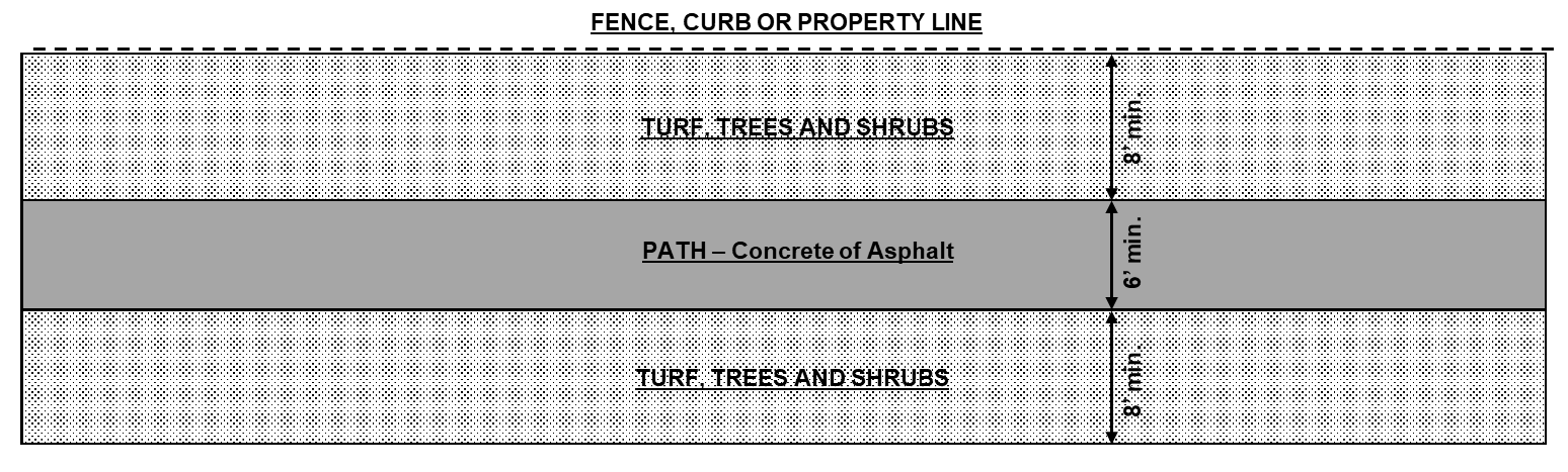
c.
Community swimming pool. Community swimming pool with landscaping and pool house with restrooms/changing rooms and gathering area.
d.
Recreational field. Two acres of turf field area for recreational activities with one 1½ inch-caliper tree for every five dwelling units to be planted on the periphery of the athletic field area.
e.
Basketball and tennis courts. One full-size concrete-edged, paved and surfaced basketball court and (two) fenced tennis courts for every 200 dwelling units (one tennis court can be replaced with two pickle ball or "sport" courts).
f.
Community garden. A community garden with garden building containing a gathering room and restrooms. The community garden area shall be two acres for every 200 dwelling units.
g.
Outdoor amphitheater. An amphitheater with stage, grass seating area—with space for two lawn chairs (or seat wall seats) for every dwelling unit.
h.
Community plaza. Large community plaza in decorative paving, fountain, seating, lighting and elements for public gatherings/farmer's market with neighborhood-scale commercial, live-work units, apartments, multi-family, condominiums or townhomes surrounding.
i.
Additional embellishment. As approved by the planning and zoning commission, may include significantly enhanced streetscaping with added trees and vegetation; community entrance with iconic wayfinding or artistic features throughout the development; additional street furnishings; additional open space elements, etc.
j.
Other open space elements. As proposed by the applicant and approved by the planning and zoning commission and city COUNCIL.
12.
Common open space. Open space and landscaped areas which are not qualified open space and held in common and maintained by all property owners in the PUD or MPC.
13.
Maintenance. The maintenance of such qualified and common open space areas shall be assured by establishment of appropriate management organization for the project (HOA). The manner of assuring maintenance and assessing such cost to individual properties shall be determined prior to the approval of the final project plans and shall be included in the title to each property.
14.
Ownership. Ownership and tax liability of private qualified and common open space area reservation shall be established in a manner acceptable to the city and made a part of the conditions of the plan approval.
(Ord. No. 4617, § 1(Exh. A), 10-4-2021; Ord. No. 4671, § 1(Exh. A), 5-16-2022; Ord. No. 4702, § 1(Exh. A), 12-5-2022; Ord. No. 4727, § 1(Exh. A), 4-3-2023; Ord. No. 4777, § 1(Exh. A), 12-18-2023; Ord. No. 4809, § 1(Exh. A), 6-3-2024)
10-27-7. - Construction observation.
The City of Nampa will provide documentation that work observed during construction was in general accordance with the project plans and specifications and the manuals referenced in subsection 10-27-1.F of this chapter. The city will prepare a set of reproducible record drawings complete with ties to water valves and service connections using information provided by the developer and contractor. Any improvements deemed unsatisfactory by the city engineer or his/her designated representative shall be corrected at the subdivider's expense. The City of Nampa's and developer's responsibilities are further outlined in the manuals referenced in subsection 10-27-1.F of this chapter.
(Ord. No. 4617, § 1(Exh. A), 10-4-2021)
10-27-8. - Subdivision improvement agreement.
The developer shall enter into a subdivision improvement agreement with the city prior to commencing development of the subdivision. Developers of large, phased subdivisions may plat an entire subdivision and enter into a subdivision agreement for each phase prior to the construction of said phase. The agreement shall be in force for a period of two years from the date entered into and may be extended by submitting a letter of request to the mayor and city council for their decision.
Upon completion of each phase of a subdivision, the City of Nampa Engineering Department will provide the developer with a final correction notice ("punch list"). The developer shall have 90 days from issuance of that notice to emplace or correct absent or deficient items. If the developer is unable to complete the project, the city may, at its discretion, cash any or all bonds and cause those items to be completed.
Time extensions may be considered upon submittal of a written and signed request by a developer to the city engineer.
Prior to the sale or transfer of ownership of any lot(s) within any new subdivision, the developer shall have placed all property pins of those lots being considered for sale or transfer on the ground in the positions depicted on the pertinent recorded final plat. In all cases, property line locations shall be defined prior to construction of any structure on a lot(s) within a subdivision. Street signage and a water system sufficient to meet fire department standards for supplying fire suppression coverage shall be in place as required by plat conditions of approval.
(Ord. No. 4617, § 1(Exh. A), 10-4-2021)
10-27-9. - Postplatting construction.
A.
Single-family detached residential subdivision build out. The City of Nampa will not issue building permits for construction or emplacement of houses within any area or upon any property being proposed for development as a residential subdivision once a preliminary plat is filed on that same property with the city. Building permits may be issued when that subdivision is fully approved by the city (or board of county planning and zoning commissioners for plans being created within the city's impact area) and recorded with the office of the Canyon County recorder, or the subdivision application is withdrawn.
A developer/owner of a subdivision must provide financial security or the subdivision be completed in accordance with regulations in section 10-27-10 of this chapter.
B.
Non-single-family residential, detached subdivisions build out. The City of Nampa will not issue building permits for construction or emplacement of structures within any area or upon any property being proposed for development as a non-single-family subdivision once a preliminary plat is filed on that same property with the city.
Exception: Foundation and footing permits may be issued for non-single-family (e.g., apartment, commercial or industrial) structures proposed in new subdivisions once:
1.
Final plat approval for the involved property has been given by the city council.
2.
Civil engineering plans have been received by the city and approved by the city engineering department, the developer/owner has received DEQ "will serve" letter and city plan approval letter from engineering.
3.
The building department, engineering department, fire department, wastewater department, and planning and zoning department have all expressed consent that such permits may be issued.
4.
Necessary infrastructure improvements (e.g., public water, sewer, pressure irrigation, and access road, fire hydrant emplacement and offsite improvements) for the buildings have been completed to the extent required by the engineering department and fire department of the city and deemed by them satisfactory. (Final occupancy of any of the structures will be predicated on completion of necessary utility line and fixture emplacement.)
5.
All building permit and plan review fees have been paid and engineering inspection fees, if applicable, have been paid.
6.
The developer(s)/owner(s) enters into an indemnification agreement with the city.
The city will not allow further construction to occur past footing and foundations on any building until all utility connection fees are paid in full for that building.
The City of Nampa will not issue final occupancy permits for apartment or commercial type structures within any area or upon any property for which a plat has been submitted to the city until the approved final plat has been recorded.
(Ord. No. 4617, § 1(Exh. A), 10-4-2021)
10-27-10. - Financial security and guarantee.
Final plat signature by the City of Nampa shall not occur in an approved residential, commercial, industrial or other subdivision until such time as the water lines, fire hydrants, required landscaping, sewer, curb, gutter and sidewalk, property pins, pressure irrigation and stormwater systems are fully constructed and tested with passing results for and within the entire subdivision and the street(s) within the same subdivision is(are) prepared and fully ready for paving. The water lines must be fully and completely tested with passing results, activated and provide sufficient water for fire suppression as noted in subsection 10-27-6.K of this chapter. As an exception, security by way of cash deposit or letter of credit may be provided for paving, required common lot and landscape buffer strips, and other minor miscellaneous improvements.
Regarding outstanding paving: The developer shall provide the city with either an approved one-year irrevocable letter of credit or cash deposit at the percentage listed below of the estimated cost of the required road surfacing which shall be filed with the public works department. The paving so covered shall be placed within six months from the date of recording of the final plat; provided, the council may extend the period by one month intervals upon showing of just cause to the council by the subdivider. Landscaping that is integral to the stormwater system (including that necessary to meet best management practices and the City of Nampa standards/requirements for stormwater collection, transportation, treatment and disposal) is exempt from financial security requirements and must be substantially complete and functioning for consideration to be given to financial security for the other landscape features.
Regarding outstanding required common lot landscaping and buffer landscaping: The developer shall provide the city with either an approved one-year irrevocable letter of credit or cash deposit at the percentage listed below of a developer's contract bid for the estimated cost of the required landscaping which shall be filed or deposited with the city engineering division. The landscaping so covered shall be placed within six months from the date of recording of the final plat; provided, the council may extend the period by one month intervals upon showing of just cause to the council by the subdivider.
In the event that all landscaping or paving is not complete within the required six month time frame, the city may withhold all remaining building permits and execute said letter of credit or cash monies to complete any outstanding required improvements.
Once building construction within a subdivision has begun, it shall be halted once 25 percent of the lots in that phase have received or been issued building permits for primary structures (e.g., houses). In order for any further building permits to be issued, remaining street paving and landscaping pertaining to the subdivision, as required by the city engineering department or fire department, shall be completed.
Minimum Financial Security Required by Stage
All monetary amounts and estimates to complete must be approved by the city engineer or his representative.
The owner and/or subdivider shall guarantee all public subdivision improvements for a one-year period following the date of acceptance by the city. Any defects discovered or repairs required during the one-year guarantee period, due to faulty workmanship or materials shall be corrected at the expense of the owner and/or subdivider, and shall be completed in a timely manner as directed by the City of Nampa, but in no case shall the correction period exceed 90 days.
(Ord. No. 4617, § 1(Exh. A), 10-4-2021; Ord. No. 4702, § 1(Exh. A), 12-5-2022)
10-27-11. - Dedications.
All streets, alleys and required easements within the subdivision must be dedicated for public use (unless approved otherwise by the city council). Land lying in the proposed subdivision's boundaries that abuts a public right-of-way shall be dedicated as per the city engineer's requirements in consultation with the city master street plan.
Dedication or provision of easement of and for all other public open/pathway/trailway space within the subdivision will be as required in accordance with the comprehensive plan of the city and per expressed requirement from the city engineer, planning and zoning commission and/or council. Where this plan calls for a larger amount of public space than the subdivider can be reasonably expected to dedicate, the land needed beyond the subdivider's fair contribution is to be reserved for acquisition by the city, provided such acquisition is made within five years from the date of approval of the subdivision.
The action of the mayor and council in exercising this power to compel dedication of public open space shall take place only after a public hearing has been held. Anyone aggrieved by the decision of the mayor and council may have the decision reviewed by a court of competent jurisdiction.
Dedication of right-of-way where it splits one or more existing lots or parcels shall require filing of a subdivision plat. Such plat shall show the proposed right-of-way together with the leftover parcels/lots to either side along the road's entire length.
(Ord. No. 4617, § 1(Exh. A), 10-4-2021)
10-27-12. - Correcting/Vacating/Amending Plats.
A.
Re-plat or amended plat. Hereinafter a re-plat or amended plat are synonymous (i.e., revising a plat or re-platting refers to the updating/altering/modifying of a preliminary plat).
B.
Amending a preliminary plat after it is approved but prior to final plat approval of any portion thereof. An amended plat design, application materials and method of filing shall be executed in accordance with the regulations established in this chapter in order to have the changes become valid and recognized.
Nevertheless, design changes to approved preliminary plats made prior to final plat approval and recording and incorporated within a final plat design shall not require rehearing of the original preliminary plat by the planning and zoning commission (or city council if they already reviewed the preliminary plat) if the proposed design change(s), does(do) not:
1.
Propose lots that are less than the minimum lot size required in the zoning district(s) pertinent to the land within a plat's boundaries;
2.
Reduce the average building lot size of the entire subdivision being platted below the minimum allowed by code;
3.
Increase the number of building lots by more than ten percent of the original request;
4.
Substantially alter the alignment of the subdivision's ingress/egress access points and/or connectivity of the subdivision's roadway network and/or re-align the internal street network such that building lots formerly fronting one street now front a different street;
5.
Reduce the lot compatibility of perimeter lots below the minimum allowed by code;
6.
Alter the position of the exterior boundaries of the preliminary plat as already approved; and/or,
7.
Violate the terms of a development agreement.
(In order to "lock in" a plat's design, a development agreement should be used at the time of annexation or rezoning when a plat is filed in conjunction with these kinds of requests.)
C.
Dividing platted property after final plat is recorded. Splitting property into three or more parcels: As iterated in subsection 10-27-4.F of this chapter, in cases where a subdivision final plat has been recorded after June 11, 2002, any of the non-common space lots therein may be divided one time into no more than two parcels without necessity to plat the proposed land division. Any one-time divisions of any of the non-common lots in any recorded subdivision, and/or any lot line adjustments internal to a subdivision may be executed by filing of a record of survey and associated legal descriptions with the county.
However, further (proposed) divisions of lots as originally platted shall require that a (new) subdivision plat (preliminary and final) be filed for and approved by the city just as done for the original plat.
D.
Correcting plats.
1.
Affidavits of correction. Affidavits of correction may be used to execute corrections to plats that are strictly/truly scrivener's errors (i.e., typos, minor changes to mapping, etc.) and thus do not have the effect of changing a plat's exterior boundaries, a recorded plat's notes, common area provision of boundaries, or, the numbering scheme used for lots and/or blocks in a subdivision.
2.
Vacation to modify plat. While a vacation request may be used to edit plat notes in accordance with State law, the City of Nampa, having authority, requires that modification or deletion of plat notes appearing on a final plat be modified only by re-platting once that final plat is recorded unless no lots in the subdivision to which the plat pertains have been sold/conveyed from the developer (i.e., the developer is still the sole owner of lots in the subdivision), in which case a vacation process through the city's council may be used to authorize the proposed note amendment(s). Alternatively, a re-plat of a subdivision may also serve to vacate easements and/or rights-of-way when filed, approved by the city, and then recorded.
3.
Vacation to erase easement or right-of-way. Vacation approval shall be required in order to either erase some or all or part of an easement or right-of-way. Vacation approval shall be required in order to move the location of all or part of an already platted and recorded right-of-way or easement. Processing of vacation requests for easements and/or rights-of-way shall be executed in accordance with provisions of Idaho State Code. Right-of-way vacations shall be done by ordinance of the city council and approved first by the same during a public hearing.
4.
Re-platting of original plat. Re-platting shall be required in order to execute a material or substantive change to a plat (i.e., to a plat's exterior boundaries, changes to a recorded plat's notes; or, alteration of plat notes or common area designation; or, a change to the numbering scheme used for lots and/or blocks in a subdivision). As allowed by subsection 10-27-4.F of this chapter, property lines internal to a subdivision may be adjusted or receive the effect of being erased, by a record of survey property line adjustment or density reduction survey. (The city acknowledges that a record of survey line adjustment or density reduction does not actually move or delete the original subdivision line(s) being affected thereby; however, the city treats the action as if a plat amendment moving or erasing the lines had been executed.)
a.
Land, exclusive of public right-of-way, that has been subdivided and platted in accordance with city law need not be vacated in order to be re-platted.
b.
Any re-plat(s) shall conform to current engineering plat language requirements in effect at the time of re-platting.
c.
A re-plat may be handled as a "short plat" if it involves seven or fewer lots, unless a substantive or material change is being proposed to the plat notes or conversion of a common lot to or from a privately held lot (e.g., building lot) in which case the plat amendment will be processed as a "full plat" application; and must be accompanied by written consent from all property owners whose land(s) are to be made a part of the plat and, if applicable, the consent of the HOA board of the subdivision (if the HOA is active and on file with the Idaho Secretary of State).
(Ord. No. 4617, § 1(Exh. A), 10-4-2021; Ord. No. 4671, § 1(Exh. A), 5-16-2022)
10-27-14. - Fees.
A.
Structure and payment. At the time of application, persons filing preliminary and/or final subdivision plats shall pay to the city a fee in an amount to be established by resolution of the city council. Also, as elsewhere noted, a separate fee amount to cover the expense of preparing any water or sanitary sewer system model needed for the development in the preliminary plat stage after the plat has been applied for through the city shall be required. That fee shall also be established by resolution of the council.
B.
Construction services and observation fee. Prior to commencing construction of a subdivision, the developer shall pay the city construction services and observation fee in an amount to be established by resolution of the city council.
(Ord. No. 4617, § 1(Exh. A), 10-4-2021)