
Nampa City Zoning Code
CHAPTER 31
- SPECIFIC AREA PLANS5
Sections:
Editor's note— Ord. No. 4727, § 1(Exh. A), adopted April 3, 2023, repealed the former chapter 31, §§ 10-31-1—10-31-9, and enacted a new chapter 31 as set out herein. The former chapter 31 pertained to airport zoning and derived from Ord. No. 4617, § 1(Exh. A), adopted October, 4, 2021.
10-31-1.- Purpose.
Specific area plans provide guidance for land use, site design, and building design for unique areas of Nampa where the zoning district requirements cannot achieve the desired results or vision for that area. Specific area plans establish an overlay district boundary that shall be shown on the Nampa future land use map. Land uses described in a specific area plan may be named differently that those shown on the Nampa future land use map. When applying specific area plan land use designations to the Nampa future land use map, the Nampa future land use map designations that best match the specific area plan designations shall be used. The Nampa future land use designations within an overlay district shall be subject to the policies in the current Nampa comprehensive plan and specific area plan that are associated with that land use.
(Ord. No. 4727, § 1(Exh. A), 4-3-2023)
10-31-2. - Applicability.
A.
Overlay districts may incorporate any zoning districts that comply with the Nampa comprehensive plan, future land use map and the specific area plan maps and will allow uses in accordance with those prescribed zoning districts per Nampa City Code section 10-3-2, unless otherwise specified herein.
B.
Specific area plans will provide standards and guidance for enhanced site design/layout, land use, streetscape treatments, recreational elements, area themes, neighborhood characteristics, circulation, infrastructure, transportation enhancements, architectural design, implementation measures, funding opportunities and any other details desired by the city and community. These standards and guidelines shall apply to an overlay district as identified by the associated specific area plan.
C.
Overlay districts shall be governed by the city council, planning and zoning commission, arts and historic preservation committee and design review committee as per Nampa City Code sections pertaining to specific zones, landscaping, parking, site improvement, and design review unless otherwise indicated in this chapter.
(Ord. No. 4727, § 1(Exh. A), 4-3-2023)
10-31-3. - Airport.
A.
Definitions.
Airport elevation: The established elevation of the highest point on the usable landing area.
Airport hazard: Any structure, tree, or use of land which obstructs the airspace required for, or is otherwise hazardous to, the flight of aircraft in landing or taking off at the airport.
Airport reference point: The point established, and the approximate geographic center of the airport landing area, and so designated.
Department: The Idaho Transportation Department.
Director: The director of the Idaho Transportation Department or his agent.
Height: For the purpose of determining the height limits in all zones set forth in this chapter, the datum shall mean sea level elevation unless otherwise specified.
Landing area: The area of the airport used for the landing, taking off, or taxiing of aircraft.
Nonconforming use: Any preexisting structure, tree or natural growth or use of land which is inconsistent with the provision of this chapter.
Nonprecision instrument runway: A runway having an existing instrument approach procedure utilizing air navigation facilities with only horizontal guidance for which a straight in nonprecision instrument approach procedure has been approved or planned and for which nonprecision approach facilities are planned or indicated on an FAA or military service planning document.
Runway: The paved surface of an airport landing strip.
Structure: An object constructed or installed by man, including, but without limitation to, buildings, towers, smokestacks and overhead transmission lines.
Tree: Any object of natural growth.
Utility runway: A runway that is constructed for and intended to be used by aircraft of 12,500 pounds maximum gross weight and less, excluding turbojet powered aircraft.
Visual runway: A runway intended solely for the operation of aircraft using visual approach procedures, with no existing instrument procedure and no instrument designation indicated on a federal aviation administration or military service approved airport layout plan or by any other FAA or military planning document.
B.
Zones. In order to carry out the provisions of this chapter, there are hereby established certain zones which include all of the land lying within the visual approach zone, transition zone, horizontal zone and conical zone. Such areas and zones are shown on the Nampa municipal airport zoning map prepared by the city engineer and dated November 15, 1971. The various zones are defined as follows:
1.
Nonprecision approach zone. This zone is established at each end of all nonprecision runways for noninstrument landings and takeoffs. The precision approach zone shall have a width of 500 feet at a distance of 200 feet beyond each end of the runway, widening thereafter uniformly to a width of 2,000 feet at a distance of 5,000 feet beyond each end of the runway, its centerline being the continuation of the centerline of the runway, and has a slope of 20 to one.
2.
Visual approach zone. This zone shall have a width of 500 feet at a distance of 300 feet beyond each end of the runway widening thereafter uniformly to a width of 1,250 feet at a distance of 5,000 feet beyond each end of the runway, its centerline being the continuation of the centerline of the runway, and has slope of 20 to one.
3.
Transitional zone. This zone extends outward and upward at right angles to the runway centerline extended at a slope of seven to one from the sides of the primary zone and from the sides of the approach zones. Transitional zones for those portions of the precision approach zone which project through and beyond the limits of the conical zone, extend a distance of 5,000 feet measured horizontally from the edge of the approach zone and at right angles to the runway centerline.
4.
Horizontal zone. A horizontal plane 150 feet above the established airport elevation, the perimeter of which is constructed by swinging arcs of specified radii from the center of each end of the primary zone of each runway and connecting the adjacent lines tangent to those arcs. The radius of each arc, is: 1) 5,000 feet for all runways designated as utility or visual, and 2) 10,000 feet for all runways other than utility designated as nonprecision instrument. The radius of the arc specified for each end of a runway will have the same arithmetical value. That value will be the highest determined for either end of the runway. When a 5,000-foot arc is encompassed by tangents connected to adjacent 10,000-foot arcs, the arch shall be disregarded on the construction of the perimeter of the horizontal zone.
5.
Conical zone. A zone extending outward and upward from the periphery of the horizontal zone at a slope of 20 to one for a horizontal distance of 4,000 feet.
6.
Primary zone. A zone longitudinally centered on a runway. The primary zone extends 200 feet beyond each end of the runway. The elevation of any point on the primary zone coincides with the elevation of the nearest point on the runway centerline. The width of a primary zone is: 1) 250 feet for utility runways having only visual approaches, and 2) 500 feet for utility runways having nonprecision instrument approaches. The width of the primary zone of a runway is that width prescribed in this subsection for the most precise approach existing or planned for either end of that runway.
7.
Approach zone. A zone longitudinally centered on the extended runway centerline and extending outward and upward from each end of the primary zone. An approach zone is applied to each end of each runway based upon the type of approach available or planned for that runway end.
a.
The inner edge of the approach zone is the same width as the primary zone and it expands uniformly to a width of: a) 1,000 feet for that end of a utility runway with only visual approaches, and b) 2,000 feet for that end of a utility runway with a nonprecision instrument approach.
b.
The approach zone for utility runways with a nonprecision instrument approach and/or visual approach extends for a horizontal distance of 5,000 feet at a slope of 20 to one.
c.
The outer width of an approach zone to an end of the runway will be that width prescribed in this subsection for the most precise approach existing or planned for that runway.
C.
Height limitations. Except as otherwise provided in this chapter, no structure or tree shall be erected, altered, allowed to grow, or maintained to a height in excess of the lower limit for airport zones established in this chapter.
1.
Nothing in this chapter shall be construed as prohibiting the growth, construction, or maintenance of any tree or structure to a height up to 30 feet above the surface of the land.
2.
Where an area is covered by more than one height limitation the more restrictive limitation shall prevail.
D.
Use restrictions. Notwithstanding any other provisions of this chapter no use may be made of land within any zones established by this chapter in such a manner as to create electrical interference with radio communication between the airport and aircraft, make it difficult for fliers to distinguish between airport lights and other lights, result in glare in the eyes of fliers using the airport, impair visibility in the vicinity of the airport or otherwise endanger aircraft.
E.
Nonconforming uses.
1.
Regulations not retroactive. The regulations prescribed by this chapter shall not be construed to require the removal, lowering, or other changes or alterations of any structure or tree not conforming to the regulations as of November 15, 1971, or otherwise interfere with the continuance of any nonconforming use. Nothing herein contained shall require any change in the construction, alteration, or intended use of any structure, the construction or alteration of which was begun prior to November 15, 1971.
2.
Marking and lighting. Notwithstanding the preceding provision of this section, the owner of any nonconforming structure or tree is required to permit the installation, operation, and maintenance thereon of such markers and lights as shall be deemed necessary by the director to indicate to the operators of aircraft in the vicinity of the airport, the presence of such airport hazards. Such markers and lights shall be installed, operated, and maintained at the expense of the owner.
F.
Permits.
1.
Future uses. Except as specifically provided in subsections A.1, A.2 and A.3 of this section, no material change shall be made in the use of land and no structure or tree shall be erected, altered, planted or otherwise established in any zone unless a permit therefor shall have been applied for and granted. Each application for a permit shall indicate the purpose for which the permit is desired, with sufficient information to allow it to be determined whether the resulting use, structure or tree would conform to the regulations herein prescribed. If such determination is in the affirmative, the permit shall be granted.
a.
In the area lying within the limits of the horizontal zone and the conical zone, no permit shall be required for any tree or structure less than 75 feet of vertical height above the ground, except when because of terrain, land contour or topographic features such tree or structure would extend above the height limits prescribed for such zone.
b.
In the areas lying within the limits of the instrument and noninstrument approach zones but at a horizontal distance of not less than 4,200 feet from each end of the runways, no permit shall be required for any tree or structure less than 76 feet of vertical height above the ground, except when such tree or structure would extend above the height limit prescribed for such instrument or noninstrument approach zone.
c.
In the areas lying within the limits of the transitional zones beyond the perimeter of the horizontal zone, no permit shall be required for any tree or structure less than 76 feet of vertical height above the ground except when such tree or structure, because of terrain, land contour or topographic features, would extend above the height limit prescribed for such transitional zones.
Nothing contained in any of the foregoing exceptions shall be construed as permitting any construction, alteration or growth of any structure or tree in excess of any of the height limits established by this chapter except as set forth in section 10-31-3 of this chapter or in violation of any other ordinances of the city.
2.
Existing uses. No permit shall be granted that would allow the establishment or creation of an airport hazard or permit a nonconforming use, structure, or tree to be made or become higher, or become a greater hazard to air navigation, than it was on November 15, 1971, or that it is when the application for a permit is made. Except as indicated, all applications for such a permit shall be granted.
3.
Nonconforming uses abandoned or destroyed. Whenever the director determines that a nonconforming structure or tree has been abandoned or more than 80 percent torn down, physically deteriorated, or decayed, no permit shall be granted that would allow such structure or tree to exceed the applicable height limit or otherwise deviate from the zoning regulations.
4.
Variances. Any person desiring to erect or increase the height of any structure, or permit the growth of any tree, or use his property not in accordance with the regulations prescribed in this chapter, must obtain a permit from the director authorizing such action. Such variances shall be allowed where literal application or enforcement of this chapter would result in practical difficulty and unnecessary hardship and the relief granted would not be contrary to the public interest or create undue hazards to air flight. Any such special permits may be allowed subject to such reasonable conditions as the director may deem necessary to effectuate the purposes of this chapter, including the condition that the owners of the structure or tree in question permit the city to install, operate and maintain at its own expense such markers and lights as may be necessary to indicate to fliers the presence of any airport hazard.
G.
Enforcement. It is the duty of the director to administer and enforce these regulations. Application for permits and variances shall be made to the director upon a form furnished by him. Applications required by this chapter to be submitted to the director shall be promptly considered and granted or denied by him. Applications for action by the department of transportation shall be transmitted by the director.
H.
Appeals. Any person aggrieved or any taxpayer affected by any decision of the department may appeal any zoning regulation or order affecting such person or taxpayer to the district court of the judicial district in which the airport hazard area involved is situated.
I.
Conflicting regulations. When there is a conflict between any of the regulations or limitations prescribed in this chapter and any other regulations applicable to the same area, whether the conflict be with respect to the height of structures or trees, the use of land, or any other matter, the more stringent limitation or requirement shall govern and prevail.
(Ord. No. 4727, § 1(Exh. A), 4-3-2023)
State Law reference— IC § 21-5011
State Law reference— IC § 21-506
10-31-4. - Highway 16.
The Nampa Highway 16 specific area plan addresses community growth in Nampa in the vicinity of State Highway 16 (SH-16). The specific area plan document provides guidance for design, infrastructure, circulation, layout, and, development expectations; and establishes a design theme for the corridor. The following standards are intended to implement that plan.
A.
Established. The Highway 16 specific area plan was established in February 2023.
B.
Boundary. The area on either side of the Highway 16 corridor bound by Ustick Road on the north, McDermott Road on the east, one half mile past Star Road to the west to the UPRR tracks, and then south on Star and Robinson Road to Airport Road on the south.
C.
Reserved.
D.
Land use designations/zones. The specific area plan outlines the zones allowed in each of the specific land use designations and describes the intent of each designation.
E.
Theme. Properties located within this overlay district shall maintain a 'traditional' theme identified for the area. When designing a building the owner/developer shall consider traditional design styles. Most major paint retailers have appropriate "heritage" color palettes, for example:
https://www.sherwin-williams.com/homeowners/color/exterior-color-schemes/americas-heritage
F.
State Highway 16 corridor design standards. Properties that front the State Highway 16 corridor shall provide enhanced design elements as follows:
1.
The landscape buffer area shall extend into the parcel 65 feet from the property line that is adjacent to Highway 16. The landscape buffer shall follow the landscape buffer guidelines established in title 10, chapter 33. Plants may be selected from the approved plant list for this specific area plan.
2.
Setbacks. In every zoning designation: for every ten feet in height over which a structure exceeds 40 feet, measured from the grade to the ceiling of the top floor of the structure, the structure shall be setback an additional five feet property line that is adjacent to Highway 16.
3.
Mechanical units. Roof mounted mechanical units are prohibited on structures that are located within 500 feet of Highway 16.
4.
Lighting.
a.
All exterior structure lighting shall be consistent with the intent of the district and shall be shielded, screened, and/or shuttered with 90° cutoff luminaires and shall be otherwise directed to prevent illumination of adjoining properties, particularly when located adjoining or across the street from residentially used or zoned properties.
b.
Lighting to highlight or illuminate architecture and signs shall be attractive without significant spillage of light upward or downward.
c.
Pedestrian circulation routes shall be illuminated.
d.
Streetlights installed by the City of Nampa, the Nampa Highway District or the Idaho Division of Transportation shall be exempt from these standards.
G.
Owyhee Storm Avenue corridor design standards. Any property/development fronting Owyhee Storm Avenue is subject the following provisions:
1.
Landscape buffer. The landscape buffers installed in this area shall be at least 35 feet wide, shall adhere to Nampa City Code, title 10, chapter 33 and use the approved plant list for this specific area plan.
2.
Lighting.
a.
All exterior structure lighting shall be consistent with the intent of the district and shall be shielded, screened, and/or shuttered with 90° cutoff luminaires and shall be otherwise directed so as to prevent illumination of adjoining properties, particularly when located adjoining or across the street from residentially used or zoned properties.
b.
Lighting to highlight or illuminate architecture and signs shall be attractive without significant spillage of light upward or downward.
c.
Pedestrian circulation routes shall be illuminated.
d.
Streetlights installed by the City of Nampa, the Nampa Highway District or the Idaho Division of Transportation shall be exempt from these standards.
H.
Designations/districts design standards.
1.
Low, medium and high density residential designations. Properties within the low, medium, and high density residential land use designation shall refer to the zoning chapters associated with the specific land use, and chapter 22, chapter 26, chapter 27, chapter 33, chapter 34 in title 10 of the Nampa City Code for specific development and design standards.
High density developments within one-half mile of Highway 16 shall comply with the following additional standards:
• Three stories minimum (additional stories are encouraged).
• Each dwelling unit shall have a balcony.
• Residential design elements shall maintain the 'traditional' theme of the specific plan area. For example, the use of masonry, wood (horizontal lap board, vertical board & batten or shake siding), brick, pitched or gabled roof is encouraged.
• A minimum five percent of the gross parcel area is required to be in outdoor open space.
• The outdoor open space shall be landscaped with trees, pathways and vegetation and other outdoor elements that make the space accessible, usable, and enjoyable for residents.
• An additional three percent (minimum) of the gross parcel area shall be indoor and/or outdoor qualified recreational space.
• The three percent qualified recreational space shall include:
Pathways (connectivity throughout).
Gathering spaces (clubhouses, pool, gazebos, picnic areas, etc.).
Play areas.
Indoor/outdoor recreational amenities as approved by the director.
2.
Commercial/residential planned development. Developments in this designation shall comply with the planned unit development standards in Nampa City Code, title 10, chapter 26.
A regional transit center is proposed for the intersection of Franklin and Highway 16. The transit center shall be designed as a plaza style development with commercial and residential elements.
Design elements in this designation shall follow guidelines outlined in subsections 10-31-4.H.1 and 10-31-4.H.4.
3.
Commercial industrial campus. Bulk standards shall follow the standards in Nampa City Code, title 10, chapter 18, IP (industrial Park) district, unless otherwise noted herein.
a.
Landscape buffer. The landscape buffers installed in this area shall be at least 25 feet wide, shall adhere to Nampa City Code, title 10, chapter 33 and use the approved plant list for this specific area plan.
b.
Building heights. One to three story buildings (maximum of 50 feet to the top of the structure/roofline).
c.
Design elements.The intent of this land use designation is to encourage the development of pedestrian-scale campus environments.
Primary entrances for tenant spaces shall create focal points on the building or entrance plaza with an architectural relationship between the buildings.
Examples of elements that are encouraged to tie the campus together may include, but are not limited to, artwork, outdoor dining areas, landscaping, recreational opportunities, and convenient access to services within the campus setting.
The primary connectivity between buildings should be pedestrian oriented without having to cross large parking areas, drive aisles, roadways or access points. The use of connected pathways through landscape buffers and common areas is encouraged.
d.
Parking. Large expanses of asphalt are discouraged. Parking areas shall be integrated into the overall connectivity between buildings and include landscaping features to soften the effect of large amounts of asphalt.
4.
Commercial. Bulk standards shall follow the standards in Nampa City Code, title 10, chapter 4, GB (gateway business) district.
5.
Neighborhood commercial. Bulk standards shall follow the standards in Nampa City Code, title 10, chapter 14, BN (neighborhood business) district.
6.
Industrial. Bulk standards shall follow the standards in Nampa City Code, title 10, chapter 19, IL (light industrial) district.
a.
Landscape buffer. The landscape buffers installed in this area shall be at least 25 feet wide, except where a property fronts Franklin Blvd, in which case the buffer shall be 35 feet wide. The landscaping shall adhere to Nampa City Code, title 10, chapter 33 and use the approved plant list for this specific area plan.
b.
Loading docks. Loading docks shall not face Highway 16 or I-84.
7.
Ustick business district.
a.
Landscape buffer. The landscape buffers installed in this area shall be at least 35 feet wide, shall adhere to Nampa City Code, title 10, chapter 33 and use the approved plant list for this specific area plan.
b.
Building orientation. Buildings shall be oriented with primary consideration being given to the visual impact from the perspective of the driver or pedestrian on Ustick Rd., and the corners of Ustick Road and Star Rd., Ustick Rd and Owyhee Storm Ave, and Ustick Road and McDermott Road. The view from this principal arterial should be dominated by a green front yard and the view of one of the primary building facades. External views of large expanses of parking lots are strongly discouraged, therefore shall be placed behind or to the side of the building.
c.
Parking. Properties with Ustick Rd frontage shall design parking lots to be located to the side or rear of the primary or front building facade with the number of spaces in the front yard being minimized. Where geographic conflicts with this intent occur, landscaping shall be used to buffer the visual impact of the parking area.
Large expanses of parking are highly discouraged and shall instead be designed as smaller modules, separated by vegetation and pedestrian connections.
d.
Lighting, streetscape and furnishings. Furnishings from a coordinated pallet provide consistency and unity in streetscape design and contribute to a welcoming feel.
Furnishings from the following list are specified for sub-district:
• Benches.
• Trash and recycling containers.
• Bike racks.
• Post top pole lights.
• Lighted bollards.
i.
Reserved.
ii.
Where open space and amenities are required, landscaping and streetscape elements and furnishings shall be installed in accordance with new construction, additions, or remodels as detailed in section 10-1-6 of this title.
iii.
Streetscape amenities and furnishings installed in the Ustick business district shall include the following elements. All furnishings shall be black color. Any substitutions shall be approved by the planning and zoning director. All fixtures shall be installed where public amenities are desired, or as required by code:
Specification sheets can be found at this Nampa planning and zoning weblink:
https://www.cityofnampa.us/DocumentCenter/View/16438/Street___Pedestrian-Furnishings-Specification-Sheets
(a)
Seating:
Six-foot "Savannah Bench"—"Slat" Style—Surface Mounted in the color "black."
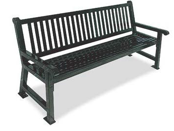
Product Information: Item # 398-9005 from "The Park Catalog."
(b)
Light posts/poles and bollards:
Pole lighting:
"Euro Large Scale" post top light—Black Textured.
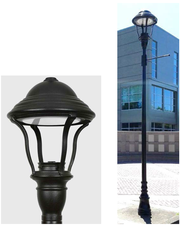
Product Information (Pole Lights): #E450LED/#E460LED from Sternberg Lighting
Bollards:
"Euro Lighted Bollard"—Black Textured.
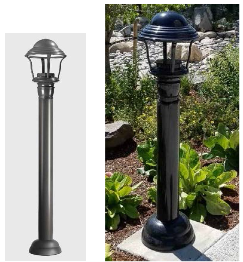
Product Information (Bollards): #E250LED-E260LED from Sternberg Lighting.
All lighting fixtures shall be installed according to code section 10-31-4.H.7.f.
(c)
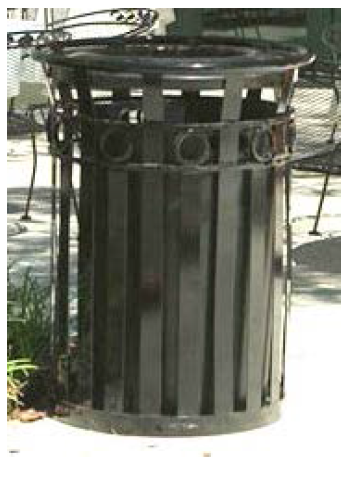
Trash and recycling containers:
"40 Gal. Receptacle with Flat Top Lid and Plastic Liner" with "TRASH" or "RECYCLING" labels, in the color "black."
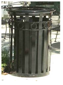
Product Information: Item # 263-1198 from "The Park Catalog."
(d)
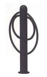
Bicycle racks:
"36H Metal Bike Bollard"—Surface Mounted in the color "black."
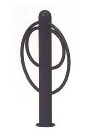
Product Information: Item # 154-1009 from "The Park Catalog."
e.
Fencing. Fencing is prohibited for nonresidential uses, except under the following conditions:
i.
Screening of mechanical or maintenance related equipment or trash receptacles. Materials used for screening shall be durable materials that match the building's façade. Materials shall include, but are not limited to brick, masonry, stone, textured masonry block, wood, or iron.
ii.
Chain link is prohibited in all instances.
Exception: School yards may be fenced with chain link where appropriate, to provide for student safety. The chain link fence may be built up to a height of six feet to enclose the area not defined as front yard. Fencing proposed in the area defined as the front yard shall meet the standards listed in subsection 10-34-10.A.7.a.
f.
Lighting. All exterior structure lighting shall be consistent with the intent of the district and shall comply with the following code sections:
i.
Exterior lighting shall be shielded, screened, and/or shuttered with 90° cutoff luminaires and shall be otherwise directed so as to prevent illumination of adjoining properties, particularly when located adjoining or across the street from residentially used or zoned properties;
ii.
Lighting to highlight or illuminate architecture and signs shall be attractive without significant spillage of light upward or downward;
iii.
All on-site pedestrian circulation systems (sidewalks, side paths, accessways) shall install post top pole lights or lighted bollards every 60 feet. In parking lots, post top pole lights shall be installed in every parking interrupt;
iv.
Streetlights installed by the City of Nampa, the Nampa Highway District or the Idaho Division of Transportation shall be exempt from these standards;
v.
The height of a freestanding light fixture shall not exceed 25 feet or the height of the principal permitted structure, whichever is less. The effective zone of light (as documented by a photometric test report) shall not trespass on any abutting residential properties;
vi.
Floodlights shall not be allowed;
vii.
Electrical feeds to outdoor light fixtures shall be placed underground, not overhead.
g.
Signage. All signage shall conform to the sign provisions of chapter 23 of this title and, in addition, shall comply with the following standards:
i.
All new signs shall be architecturally compatible with the traditional design theme for the district;
ii.
Internally illuminated projecting cabinet signs are not permitted;
iii.
Signs that are wholly or in part electronic message center displays shall not be allowed notwithstanding any other provision of this Code that makes allowances for electronic reader board signs;
iv.
Manual reader boards are prohibited;
v.
Portable pedestrian signs or "sandwich boards":
• Fluorescent, black or bright colors are not permitted
• A maximum square footage of nine feet per side, with a 36 inch maximum height.
• Each portable pedestrian sign must be removed during nonbusiness hours.
• Only one portable sign per business is permitted.
• The portable sign must also be placed within 50 feet of the business for which they are advertising;
• Shall not block any portion of a sidewalk/ADA accessible route.
vi.
Rotating, moving or flashing signs are not permitted;
xv.
City sponsored "wayfinding" signage that identifies specific businesses or district amenities is allowed to be installed by city staff on the streetlight poles.
8.
Waterways district.
a.
Landscape buffer. The landscape buffers installed in this area shall be at least 25 feet wide, except where a property fronts Cherry Lane, in which case the buffer shall be 35 feet wide. The landscaping shall adhere to Nampa City Code, title 10, chapter 33 and use the approved plant list for this specific area plan.
b.
Ten Mile Creek pathway. Properties along Ten Mile Creek shall dedicate a 20-foot easement on both sides of the waterway and install a ten-foot pathway within said easement. Development shall also consider installing bridges for access from north to south of the waterway.
c.
Building orientation. Buildings shall be oriented with primary consideration being given to the visual impact from the perspective of the pedestrian along Ten Mile Creek. The view from this waterway should be dominated by a green front yard and the view one of the primary building facades. External views of large expanses of parking lots are strongly discouraged.
d.
Parking. Parking areas shall not be located adjacent to the Ten Mile Creek pathway. Properties with Ten Mile Creek frontage shall design parking lots to be located on the property in such away as to reduce the visual impact to pedestrians using the Ten Mile Creek pathway. Where geographic conflicts with this intent occur, landscaping shall be used to buffer the visual impact of the parking area.
Large expanses of parking are highly discouraged and shall instead be designed as smaller modules, separated by vegetation and pedestrian connections.
e.
Lighting, streetscape and furnishings. Furnishings from a coordinated pallet provide consistency and unity in streetscape design and contribute to a welcoming feel.
Furnishings from the following list are specified for sub-district:
• Benches.
• Trash and recycling containers.
• Bike racks.
• Post top pole lights.
• Lighted bollards.
i.
Where open space and amenities are required, landscaping and streetscape elements and furnishings shall be installed in accordance with new construction, additions, or remodels as detailed in section 10-1-6 of this title.
ii.
Streetscape amenities and furnishings installed in the waterways district shall include the following elements. All furnishings shall be black color. Any substitutions shall be approved by the planning and zoning director. All fixtures shall be installed where public amenities are desired, or as required by code:
Specification sheets can be found at this Nampa planning and zoning weblink:
https://www.cityofnampa.us/DocumentCenter/View/16438/Street-Pedestrian-Furnishings-Specification-Sheets
(a)
Seating:
Six foot (6') "Savannah Bench"—"Morning" Style—Surface Mounted, in the color "black."
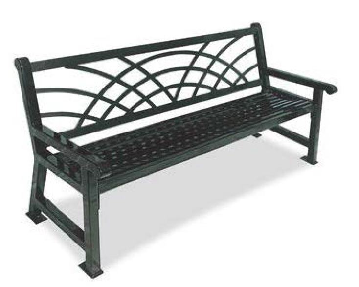
Product Information: Item # 398-9005 from "The Park Catalog."
(b)
Light Posts/Poles and Bollards:
Pole lighting: "Euro Large Scale" post top light—Black Textured.
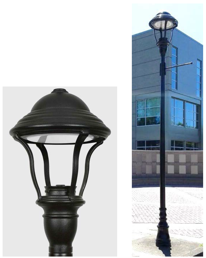
Product Information (Pole Lights): #E450LED/#E460LED from Sternberg Lighting.
Bollards:
"Euro Lighted Bollard"—Black Textured.
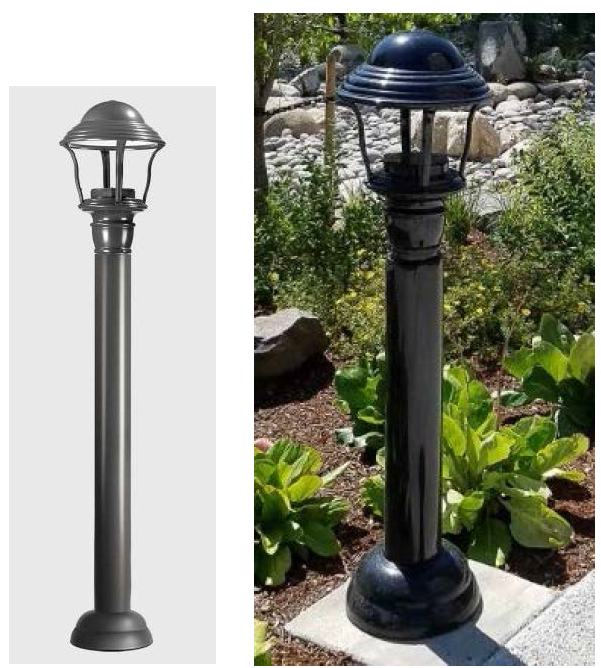
Product Information (Bollards): #E250LED-E260LED from Sternberg Lighting.
All lighting fixtures shall be installed according to code section 10-31-4.H.7.f.
(c)
Trash and Recycling Containers:
"40 Gal. Receptacle with Flat Top Lid and Plastic Liner" with "TRASH" or "RECYCLING" labels, in the color "black."
Product Information: Item # 263-1198 from "The Park Catalog."
(d)
Bike Racks:
"36H Metal Bike Bollard"—Surface Mounted, the color "black."
Product Information: Item # 154-1009 from "The Park Catalog."
f.
Lighting. All exterior structure lighting shall be consistent with the intent of the district and shall comply with the following code sections:
i.
Exterior lighting shall be shielded, screened, and/or shuttered with 90° cutoff luminaires and shall be otherwise directed so as to prevent illumination of adjoining properties, particularly when located adjoining or across the street from residential or residential-zoned properties;
ii.
Lighting to highlight or illuminate architecture and signs shall be attractive without significant spillage of light upward or downward;
iii.
All on-site pedestrian circulation systems (sidewalks, side paths, accessways) shall install post top pole lights or lighted bollards every 60 feet. In parking lots, post top pole lights shall be installed in every parking interrupt;
iv.
Streetlights installed by the City of Nampa, the Nampa Highway District or the Idaho Division of Transportation shall be exempt from these standards;
v.
The height of a freestanding light fixture shall not exceed 25 feet or the height of the principal permitted structure, whichever is less. The effective zone of light (as documented by a photometric test report) shall not trespass on any abutting residential properties;
vi.
Floodlights shall not be allowed;
vii.
Electrical feeds to outdoor light fixtures shall be placed underground, not overhead.
g.
Fences and walls. Fencing is prohibited for nonresidential uses, except under the following conditions:
i.
If desired, fencing along Ten Mile Creek shall be an open vision style fencing.
ii.
Screening of mechanical or maintenance related equipment or trash receptacles. Materials used for screening shall be durable materials that match the building's façade. Materials shall include, but are not limited to brick, masonry, stone, textured masonry block, wood, or iron.
iii.
Chain link is prohibited in all instances.
Exception: School yards may be fenced with chain link where appropriate, to provide for student safety. The chain link fence may be built up to a height of six feet to enclose the area not defined as front yard. Fencing proposed in the area defined as the front yard shall meet the standards listed in subsection 10-34-10.A.7.a.
I.
Gateways and landmarks. Properties where "gateways" are indicated on the specific area plan land use designation map (page 25 of the Nampa State Highway 16 corridor specific area plan), are required to dedicate an easement to the City of Nampa for the purposes of installing an entry feature.
J.
Fences and walls. As an exception to the usual design review standards (subsection 10-34-10.A.2.a), this area requires simple traditional, farmstyle fencing constructed of high quality wood, stone, or wrought iron. Creative design along the length of the fence is encouraged.
K.
Open space, public amenities, and pathways.
1.
Open space and amenities. Nonresidential buildings (with a footprint over 5,000 square feet in area) shall provide a gathering space area that equates to ten percent of the gross building footprint, and shall include pedestrian amenities (i.e., walkways, outdoor dining, plazas, water features with seating, etc.). Required landscape buffers and drainage areas are not to be considered in the qualified open space calculation. Residential open space shall be regulated by Nampa City Code sections 10-26, 10-27 and 10-34.
2.
Pathway. Ten-foot sidepath along Ustick Rd and Owyhee Storm Ave frontages (both sides) is required to be installed within the landscape buffer.
L.
Sign placeholding. The locations of future wall-mounted or free-standing signs shall be identified on site and elevation drawings provided to the city as part of a design review application.
• Free standing pole signs are prohibited throughout this overlay district.
• Monument signs shall be integrated into the frontage buffer of the property.
• Only projecting (blade) or painted wall signs shall be allowed for structures/tenants located within the Ustick business district and adjacent to the Owyhee Storm Avenue corridor.
M.
Conflicting regulations. When there is a conflict between any of the regulations or limitations prescribed in this chapter and any other regulations applicable to the same area, whether the conflict be with respect to the height of structures or trees, the use of land, or any other matter, the more stringent limitation or requirement shall govern and prevail.
N.
Future land use map. Adjacent comprehensive plan future land use map land use designations may not be "stretched" into the Highway 16 specific area plan unless as proposed as part of a planned unit development or master planned community.
(Ord. No. 4727, § 1(Exh. A), 4-3-2023; Ord. No. 4776, § 1(Exh. A), 12-18-2023; Ord. No. 4777, § 1(Exh. A), 12-18-2023)
State Law reference— IC § 21-5011
State Law reference— IC § 21-506
10-31-5. - Highway 20/26.
The Nampa Highway 20/26 specific area plan addresses community growth in Nampa in the vicinity of Highway 20/26 and Ustick Rd. The specific area plan document provides guidance for infrastructure, circulation, land use, and, development expectations for the area. The following standards are intended to implement that plan.
A.
Established. The Highway 20/26 specific area plan was established in February 2023.
B.
Boundary. The area that encompasses the northern most Nampa area of city impact and is bound by Ustick Rd to the south, the Boise River to the north, N Can-Ada Rd to the east and Madison Rd to the west.
C.
Land use designations/zones. Some designations noted in the specific area plan will continue to be regulated by the city zoning code that is associated with the zone allowed within the future land use designation. Where a "master planned community" is identified, the standards in NCC title 10, chapter 26, shall apply. The following designations have additional requirements:
1.
Very low density residential (VLDR).
a.
The only zones allowed in VLDR are RA (suburban residential) or AG (agriculture).
b.
Residential structural setbacks from the Boise River shall be outside the FEMA identified floodway. All other setbacks shall adhere to the requirements of the zoning district in which they are located.
2.
Very low to low density cluster (VLDR/LDR cluster). A cluster development in the RA (suburban residential) and AG (agriculture) zoning shall comply with the cluster development standards in NCC title 10, chapter 26.
3.
Medium density residential. The zoning district selected shall reflect the densities identified in the specific area plan.
4.
High density residential (HDR). The zoning district selected shall reflect the densities identified in the specific area plan.
a.
Townhouse. Properties within the HDR townhouses designation shall provide over 50 percent of the development area in townhouses. The remainder of the area of the proposed development may be developed in land uses as allowed by the zoning district.
5.
Neighborhood commercial. The only zoning district allowed in the neighborhood commercial designation is the BN (neighborhood business) zoning district.
6.
Regional commercial. When identified as the sole designation on the specific area plan map, the only zoning district allowed in the regional commercial designation is the BC (community business) zoning district. When identified as the sole designation on the specific area plan map, the following uses, as listed in NCC title 10, chapter 3, are not allowed:
• Automobile body, paint shop.
• Dwelling, multiple-family—up to three stories.
• Dwelling, multiple-family—four plus stories.
• Lumberyard, retail.
• Machine shop.
• Manufacture, assembly or packaging of products from previously prepared materials.
• Manufacturing, compounding, processing, assembling, packaging, treatment or fabrication of the following products: textile, apparel and related items, building materials, furniture and fixtures, paper, chemicals and chemical products, petroleum, electronic, concrete, rubber, plastic, metal, professional and scientific, or any combination thereof of items, materials or goods.
• Monument works, stone.
• Petroleum storage.
7.
Agribusiness. The only zoning districts allowed in the agribusiness designation are the BC (community business), IP (industrial park) or IL (light industrial) zoning districts. The following uses, as listed in NCC title 10, chapter 3, are the only uses allowed in this designated area:
• Agricultural supply.
• Animal shelter.
• Equipment/implement sales or rental, includes large or heavy equipment.
• Farmer's market.
• Grain/feed and seed processing and sales.
• Greenhouse.
• Grooming establishment, animal.
• Horticultural services.
• Hospital, animal (veterinary).
• Kennel, commercial.
• Laboratory.
• Lockers, cold storage, retail use only.
• Lumberyard, retail.
• Meat market.
• Monument works, stone.
• Orchards, tree crops, plant, or tree farm.
• Plant nurseries.
• Research facility.
• Restaurant, with/without a drive-thru or walk-up.
• Retail, general and bulky.
• Riding stable, commercial.
• Taxidermy.
The following building type is not allowed in this designated area:
• Commercial or industrial warehousing/flex space.
• Multi-family residential.
D.
Buffering residential. Regardless of the zone, developments adjacent to residential uses shall provide a ten-foot landscape along the property line that provides visual screening between land uses as per Nampa City Code section 10-33.
E.
Landscape buffer along Highway 20/26. Properties fronting Highway 20/26 shall provide a 35-foot landscape buffer. All other properties will be regulated by Nampa City Code section 10-33.
F.
Conflicting regulations. When there is a conflict between any of the regulations or limitations prescribed in this chapter and any other regulations applicable to the same area, whether the conflict be with respect to the height of structures or trees, the use of land, or any other matter, the more stringent limitation or requirement shall govern and prevail.
G.
Future land use map. Adjacent comprehensive plan future land use map land use designations may not be "stretched" into the Highway 16 specific area plan unless as proposed as part of a planned unit development or master planned community.
(Ord. No. 4727, § 1(Exh. A), 4-3-2023; Ord. No. 4777, § 1(Exh. A), 12-18-2023)
10-31-6. - Midland corridor.
Reserved.
(Ord. No. 4727, § 1(Exh. A), 4-3-2023)
10-31-7. - Southwest Nampa.
Reserved.
(Ord. No. 4727, § 1(Exh. A), 4-3-2023)
10-31-8. - Southeast Nampa.
Reserved.
(Ord. No. 4727, § 1(Exh. A), 4-3-2023)
10-31-9. - Central Nampa.
Reserved.
(Ord. No. 4727, § 1(Exh. A), 4-3-2023)
10-31-10. - Old Nampa neighborhood.
Reserved.
(Ord. No. 4727, § 1(Exh. A), 4-3-2023)