
Pawleys Island City Zoning Code
ARTICLE 2
- DEFINITIONS
2-1. The word "shall" is always mandatory. The word "lot" includes the word "plot" or "parcel." The word "building" includes the word "structure." The word "person" includes a firm, association, organization, partnership, trust company or corporation as well as an individual. The word "used" or "occupied" as applied to any land or building shall be construed to include the words "intended," "arranged," or "designed to be used or occupied." The words "zoning map" shall mean the official zoning map of the town. Words used in singular include the plural and words used in plural include the singular. Unless specifically defined below, words or phrases used in this ordinance shall be interpreted so as to give them the meaning they have in common usage and to give this ordinance its most reasonable application.
2-2. Abandoned vehicle: A motor vehicle that is inoperable or is left unattended on public property for more than seventy-two hours, or a motor vehicle that has remained illegally on private or public property for a period of more than seven days without the consent of the owner or person in control of the property.
2-3. Abandonment: The relinquishment of property, or a cessation of the use of the property, by the owner with the intention neither of transferring rights to the property to another owner nor of resuming the use of the property.
2-4. Access: The right to cross between public and private property, thereby permitting pedestrians and vehicles to enter and leave the property.
2-5. Addition (to an existing building): Any walled and roofed expansion to the perimeter of a building in which the addition is connected by a common load-bearing wall other than a fire wall. Any walled and roofed addition which is connected by a fire wall or is separated by independent perimeter load-bearing walls is new construction. The construction of an additional floor to an existing building shall be considered to be an addition to an existing building.
2-5.5. Agricultural structure: A structure used solely for agricultural purposes in which the use is exclusively in connection with the production, harvesting, storage, drying, or raising of agricultural commodities, including the raising of livestock. Agricultural land uses and associated structures are not allowed on Pawleys Island.
2-6. Apartment: A part of a principal building consisting of a room or rooms intended, designed or used as a residence by an individual or a single family.
2-6.3. Appeal (flood hazard reduction): A request for a review of the local floodplain administrator's interpretation of any provision of article 5 flood hazard reduction.
2-6.6. Area of shallow flooding: A designated AO or VO Zone on a community's flood insurance rate map (FIRM) with base flood depths of one to three feet where a clearly defined channel does not exist, where the path of flooding is unpredictable and indeterminate, and where velocity flow may be evident.
2-7. Area of special flood hazard: The land in the floodplain within a community subject to a one percent or greater chance of flooding in any given year.
2-8. Artificial lights: Any source of light emanating from a manmade device, including but not limited to incandescent mercury vapor, metal halide, or sodium lamps, flashlights, spotlights, street lights, vehicular lights, construction or security lights.
2-9. Base flood: The flood having a one percent chance of being equaled or exceeded in any given year.
2-9.1. Base flood elevation (BFE): The elevation shown on the current FIRM map for each lot or property and from which minimum building heights are determined.
2-9.5. Basement: Means any enclosed area of a building that is below grade on all sides. Basements are prohibited on Pawleys Island.
2-10. Beach: That area of unconsolidated material that extends landward from the mean low water line to the place where there is a marked change in material or physiographic form, or to the line of permanent vegetation (usually the effective limit of storm waves).
2-10.1. Beach boardwalk or walkway (only one per dwelling): A structure utilized for the purpose of providing pedestrian access from a residence to the beach. The maximum width of such structure shall not exceed six feet and shall be in effect and enforced retroactively.
2-11. Biodegradable: Capable of being decomposed by the action of micro-organisms.
2-11.5. Border area: The area of a lot that is between the property line and the setback line of the lot.
2-12. Breakaway walls: A wall that is not part of the structural support of the building and is intended through its design and construction to collapse under specific lateral loading forces without causing damage to the elevated portion of the building or the supporting foundation system.
2-13. Buffer strip: A screening material acceptable to the building inspector which has such characteristics as will provide an obscuring screen not less than six feet in height.
2-13.5. Buildable area: The area of a lot within applicable setback lines where building can occur.
2-14. Buildable lot: To determine that a lot meets minimum square footage requirements as stated in Article III, 3-2.2(C)1) and 2) and 3-2.3(C)1), 2) and 3), it will be defined as "all property encompassed within the boundaries of the lot lines as shown on a registered and recorded plat of the property."
2-15. Building: Any structure having a roof supported by columns or walls and intended for the shelter, housing or enclosure of persons, animals or chattel. The connection of two buildings by means of a porch, breezeway, carport or other similar structure with or without a roof, shall not be considered as one building.
2-15.1. Building, principal: A building in which is conducted the main or principal use of the lot on which said building is located.
2-15.2. Building, accessory: Structures that are located on the same parcel of property as the principal structure and the use of which is incidental to the use of the principal structure. Accessory structures should constitute a minimal investment (no more than ten percent of the value of the primary structure), may not be used for human habitation, and be designed to have minimal flood damage potential. Examples of accessory structures are satellite dishes, detached garages, carports, and storage sheds.
2-15.3. Building height: The vertical distance measured from the design flood elevation as indicated on the FIRM to the highest point of the roof.
2-15.4 Building setback line: A line delineating the minimum allowable distance between the property line and a building on a lot, within which no buildings or other structures shall be placed except elevators, roof over hangs, on-grade patios, fences, sidewalks, pavement, air conditioning units and signs.
2-15.5. Building inspector: An individual or agent or agency as designated from time to time by the town council.
2-16. Cabana/gazebo: A single open deck not exceeding 200 square feet in area (covered or uncovered) nor a height of more than 12 feet measured from the base flood elevation. Neither cabanas nor gazebos shall be equipped with kitchen utilities, bathroom utilities or accommodations for overnight lodging; provided however, that a shower may be permitted.
2-17. Club: Buildings and facilities owned or operated by an association or persons for a social or recreational purpose, but not operated primarily for profit or to render a service which is customarily carried on as a business.
2-18. Coastal high hazard area: An area of special flood hazard extending from offshore to the inland limit of the primary frontal dune along an open coast and any other area subject to velocity wave action from storms or seismic sources.
2-19. Common nuisances: A public nuisance that is a condition of things which is prejudicial to the health, comfort, safety, property, sense of decency or morals of the citizens at large, resulting either from an act not warranted by law, or from neglect of a duty imposed by law.
2-20. Construction, demolition and land clearing wastes: Any type of solid waste resulting from land clearing operations, the construction of new buildings or remodeled structures, or the demolition of any building or structure.
2-21. Council: The Town Council of the Town of Pawleys Island, South Carolina.
2-21.5. Critical development: Development that is critical to the community's public health and safety and is essential to the orderly functioning of a community. Town hall is an example of a critical development on Pawleys Island.
2-22. Customary, incidental home occupation: Any use conducted entirely within a dwelling and carried on by the occupant thereof, which use is clearly incidental and secondary to the use of a dwelling for residential purposes and does not change the character thereof, and in the conduct of which no person not a resident on the premises is employed specifically in connection with the activity. Provided further that no mechanical equipment is installed and used except such as is normally used for domestic or professional purposes, and that not over 25 percent of the total floor space of any structure is used for incidental home occupations. No traffic shall be generated by such home occupations in greater volumes than would normally be expected in a residential neighborhood, and any need for parking generated by the conduct of such home occupation shall be met off the street and in the side and rear yard if possible.
2-23. Dead animals: The term includes, but is not limited to, livestock, dogs, cats, horses, typical household pets, birds and other fowl, etc., whose life-sustaining biological functions have ceased.
2-24. Derelict vehicle: A derelict vehicle is any type of vehicle or boat:
2-24.1. Whose certificate of registration has expired and the registered and legal owner no longer resides at the address listed on the last certificate of registration on record with the appropriate state agency; or,
2-24.2. Whose major parts have been removed so as to render the vehicle inoperable and incapable of passing inspection as required under existing standards; or
2-24.3. Manufacturer's serial plates, motor vehicle identification numbers, license number plates and any other means of identification have been removed so as to nullify efforts to locate or identify the registered owner; or
2-24.4. Whose registered and legal owner of record disclaims ownership or releases his rights thereto; or
2-24.5. Which is more than seven years old and does not bear a current license or registration as required by the appropriate state agency.
2-25. Design flood elevation (DFE): The regulatory flood elevation adopted by the Town of Pawleys Island which is three feet above the base flood elevation (BFE).
2-26. Development: Any manmade change to improved or unimproved real estate, including, but not limited to, buildings or other structures, mining, dredging, filling, grading, paving, excavating, drilling operations or permanent storage of materials or equipment.
2-26.5. Diameter breast height (DBH): Being the diameter in inches of a tree measured at four feet from the ground.
2-27. District: Any section of the Town of Pawleys Island, South Carolina for which the regulations governing the use of land, density, bulk, height and coverage of buildings and other structures are uniform.
2-28. Dwelling, group: A building designed, constructed or reconstructed and used to provide lodging for compensation with or without meals. If meals are provided, they shall be prepared and served in a centrally located facility and not in individual rooms. Group dwellings include the terms "rooming house," "boarding house," "tourist home" and "bed and breakfast home."
2-28.1. If food service facilities are provided, they shall:
(A)
Only accommodate boarders of said establishment and their guests;
(B)
Provide a minimum of 50 square feet of dining area for each rental room; and
(C)
Provide a loading and unloading zone for the kitchen and/or laundry.
2-29. Dwelling unit: A single unit providing complete independent living facilities for one or more persons, including permanent provisions for living, sleeping, eating, cooking and sanitation, as required by this Unified Development Code. It is expressly prohibited that any single-family dwelling unit can be converted into a two-family dwelling or duplex. It is further expressly prohibited for any single-family dwelling to be used, advertised or rented as anything other than a single-family unit anywhere on Pawleys Island.
2-29.1. Dwelling, single-family: A building designed, constructed and used for one dwelling unit. (Does not include mobile homes.)
2-29.2. Dwelling, two-family or duplex: A structure on a single lot containing two dwelling units. New duplexes are prohibited.
2-29.3. Dwelling, multifamily: A building designed, constructed or reconstructed and used for more than two dwelling units, with each dwelling unit having a common structural wall with any other dwelling unit on the same floor.
2-29.4. Dwelling condominium: A building and land containing more than one dwelling unit, certain parts of which are held in common ownership such as yards, foundations, basements, floors, walls, hallways, stairways, elevators, or other related common elements, together with the individual ownership in fee of a particular dwelling unit or apartment within such building. The terms condominium and "horizontal property regime", as authorized by Title 27, Chapter 31 of the State of South Carolina Code of Laws, shall have the same meaning when used within this code.
For the purposes of land use classification and determining the zoning district(s) for which such use would be permitted, a condominium shall be considered a multifamily dwelling under this code, irrespective of the number of units or apartments contained within a building.
2-30. Easement: A grant by the property owner to any person, firm, corporation or to the general public of the use of a strip or parcel of land for a specified purpose.
2-31. Elevated building: A non-basement building built to have the lowest floor elevated above the ground level by means of solid foundation perimeter walls, pilings, columns, piers, or shear walls parallel to the flow of water.
2-32. Engineer: A registered professional engineer in good standing with the South Carolina Board of Engineering Examiners.
2-32.5. Executive Order 11988 (floodplain management): Issued by President Carter in 1977, this order requires that no federally assisted activities be conducted in or have the potential to affect identified special flood hazard areas, unless there is no practicable alternative.
2-33. Existing construction: Means, for the purposes of determining flood insurance rates, structures for which the start of construction commenced before March 16, 1989.
2-33.5. Existing manufactured home park or manufactured home subdivision: A manufactured home park or subdivision for which the construction of facilities for servicing the lots on which the manufactured homes are to be affixed (including, at a minimum, the installation of utilities, the construction of streets, and either final site grading or the pouring of concrete pads) is completed before December 8, 2003. Manufactured home parks and manufactured home subdivisions are prohibited on Pawleys Island.
2-34. Family: One or more persons occupying a premises and living together as a single housekeeping unit.
2-35. Fence: A barrier or enclosure designed and constructed to prevent escape or intrusion or to mark a boundary. Fences may only be constructed of wood material, wood fiber composite material, brick or combinations thereof. (See section 3-4.12 for specific regulations for fences.)
2-36. Flood or flooding: A general and temporary condition of partial or complete inundation of normally dry land areas from:
2-36.1. The overflow of inland or tidal waters; or
2-36.2. The unusual and rapid accumulation or runoff of surface waters from any source.
2-36.5. Flood hazard boundary map (FHBM): An official map of a community, issued by the Federal Emergency Management Agency, where the boundaries of the areas of special flood hazard have been defined as zone A.
2-37. Flood insurance rate map (FIRM): An official map of a community, on which the Federal Emergency Management Agency has delineated both the areas of special flood hazard and the risk premium zones applicable to the community.
2-38. Flood insurance study: The official report provided by the Federal Emergency Management Agency. The report contains flood profiles, as well as the flood boundary map and the water surface elevation of the base flood.
2-38.5. Flood-resistant material: Any building material capable of withstanding direct and prolonged contact (minimum 72 hours) with floodwaters without sustaining damage that requires more than low-cost cosmetic repair. Any material that is water-soluble or is not resistant to alkali or acid in water, including normal adhesives for above-grade use, is not flood-resistant. Pressure-treated lumber or naturally decay-resistant lumbers are acceptable flooring materials. Sheet-type flooring coverings that restrict evaporation from below and materials that are impervious, but dimensionally unstable are not acceptable. Materials that absorb or retain water excessively after submergence are not flood resistant. Please refer to Technical Bulletin 2, Flood Damage-Resistant Materials Requirements, available from the Federal Emergency Management Agency. Class four and five materials, referenced therein, are acceptable flood-resistant materials.
2-39. Floodlight: Reflector-type light fixture which is attached directly to a building and which is unshielded.
2-39.5. Floodway: The channel of a river or other watercourse and the adjacent land areas that must be reserved in order to discharge the base flood without cumulatively increasing the water surface elevation more than one foot. There are no floodways within the special flood hazard areas of the town.
2-40. Floor: The top surface of an enclosed area in a building, i.e. top of slab in concrete slab construction or top of wood flooring in wood frame construction. The term does not include the floor of a garage used solely for parking vehicles.
2-41. Floor area ratio (FAR): A percentage calculated by dividing the total living space (heated floor area) of a dwelling unit on a lot, by the total area of contiguous land of such lot.
2-41.3. Freeboard: A factor of safety usually expressed in feet above a flood level for purposes of floodplain management. "Freeboard" tends to compensate for the many unknown factors that could contribute to flood heights greater than the height calculated for a selected size flood and floodway conditions, such as wave action, bridge openings, and the hydrological effect of urbanization of the watershed. There is a three feet freeboard requirement as established by the design flood elevation definition adopted by the town.
2-41.6. Functionally dependent use: A use which cannot perform its intended purpose unless it is located or carried out in close proximity to water. The term includes only docking facilities, port facilities that are necessary for the loading and unloading of cargo or passengers, and ship building and ship repair facilities, but does not include long-term storage or related manufacturing facilities. There are no functionally dependent uses in the town.
2-42. Garbage: Organic, putrescible wastes from the preparation, cooking or serving of food. It shall also include all household solid waste materials, tree cuttings, leaves, garden vegetation, trimmings and other types of trash.
2-43. Garbage container: A container constructed of plastic or other durable, watertight material.
2-44. Hazardous waste: Any waste, or combination of wastes, of a solid, liquid, contained gaseous, or semisolid form which because of its quantity, concentration, or physical, chemical, or infectious characteristics may:
2-44.1. Cause or significantly contribute to an increase in mortality or an increase in serious irreversible, or incapacitating reversible illness; or
2-44.2. Pose a substantial present or potential hazard to human health or the environment when improperly treated, stored, transported, or disposed of, or otherwise managed. Such wastes may include, but are not limited to, those which are toxic, corrosive, flammable, irritants, strong sensitizers, persistent in nature, assimilated or concentrated in tissue, or which generate pressure through decomposition, heat, or other means. The term does not include solid or dissolved materials in domestic sewage, or solid dissolved materials in irrigation return flows, or industrial discharges which are point sources subject to state or federal permits.
2-45. Highest adjacent grade: The highest natural elevation of the ground surface, prior to construction, next to the proposed walls of a building.
2-46. Historic structure: Any structure that is:
2-46.1. Listed individually in the National Register of Historic Places (a listing maintained by the Department of Interior) or preliminarily determined by the Secretary of the Interior as meeting the requirements for individual listing in the National Register;
2-46.2. Certified or preliminarily determined by the Secretary of the Interior as contributing to the historical significance of a registered historic district or a district preliminarily determined by the Secretary to qualify as a registered historic district;
2-46.3. Individually listed on a state inventory of historic places in states with historic preservation programs which have been approved by the Secretary of the Interior; or
2-46.4. Individually listed on a local inventory of historic places in communities with historic preservation programs that have been certified either:
(a)
By an approval state program as determined by the Secretary of the Interior; or
(b)
Directly by the Secretary of the Interior in states without approved programs.
Some structures or districts listed on the state or local inventories may not be "historic" as cited above but have been included on the inventories because it was believed that the structures or districts have the potential for meeting the "historic" structure criteria of the DOI. In order for these structures to meet NFIP historic structure criteria, it must be demonstrated and evidenced that the South Carolina Department of Archives and History has individually determined that the structure or district meets DOI historic structure criteria.
2-47. Impervious material: Any material through which water cannot penetrate. Such material includes, but is not limited to principal dwelling units, accessory structures, swimming pools, covered porches, solid decks and concrete, asphalt or similar paving surfaces. Said paving surfaces specifically exclude gravel, shell, crushed stone, pervious concrete or a permeable paving system of concrete pavers or brick pavers as defined in [subsection] (A) below. Driveways and off-street parking surfaces are specifically prohibited from being constructed out of impervious material
2-47.5. Increased cost of compliance (ICC): Applies to all new and renewed flood insurance policies effective on and after June 1, 1997. The NFIP shall enable the purchase of insurance to cover the cost of compliance with land use and control measures established under Section 1361. It provides coverage for the payment of a claim to help pay for the cost to comply with state or community floodplain management laws or ordinances after a flood event in which a building has been declared substantially or repetitively damaged.
(A)
Also allowable is a permeable paving system, installed as specified, or with minimum two and three-eighths-inch concrete or brick pavers on a two-inch layer of permeable, open-graded crushed stone bedding (typically ASTM No. 8 stone), placed over an open-graded base (typically No. 57 stone six inches thick). Each individual paver shall not exceed 100 square inches in surface coverage and spacing between the pavers shall be three-eighths to one-half-inch filled with ASTM 8.89 or [No.] 9 stone in the joints. The installer should be one which has successfully completed pervious concrete or brick paver installations similar in design, materials and extent.
2-47.5. Increased cost of compliance (ICC}: Applies to all new and renewed flood insurance policies effective on and after June 1, 1997. The NFIP shall enable the purchase of insurance to cover the cost of compliance with land use and control measures established under Section 1361. It provides coverage for the payment of a claim to help pay for the cost to comply with State or community floodplain management laws or ordinances after a flood event in which a building has been declared substantially or repetitively damaged.
2-48. Industrial waste: Any liquid, gaseous, solid or other waste substance or a combination thereof resulting from any process of industry, manufacturing, trade or business or from the development of any natural resources.
2-49. Inoperable vehicle: Any motor driven vehicle, regardless of size, which is incapable of being self-propelled upon the public streets of the town or which does not meet the requirements for operation upon the public streets, including a current motor vehicle license.
2-50. Junk: Any appliance, vehicle or large household item, except motorized vehicles, that is discarded or is in a state of disrepair, is inoperable, and does not possess current license plates.
2-51. Junk motorized vehicle: Any automobile, truck or other motorized vehicle which has been discarded or is in a state of disrepair, is inoperable, and does not possess current license plates.
2-52. Limited storage: An area used for storage and intended to be limited to incidental items which can withstand exposure to the elements and have low flood damage potential. Such an area must be of flood-resistant or breakaway material, void of utilities except for essential lighting and cannot be temperature controlled. If the area is located below the base flood elevation, it must meet the requirements of section 5-4 of these regulations.
2-53. Litter: All waste material including but not limited to disposable packages or containers, trash, garbage or refuse, but not including the wastes of the primary process of mining, logging, sawmilling or farming which is improperly discarded and exposed to public view.
2-54. Lot: A parcel of land which fronts on and has access to a public street and which is occupied or intended to be occupied by a building or buildings with customary accessories and open space.
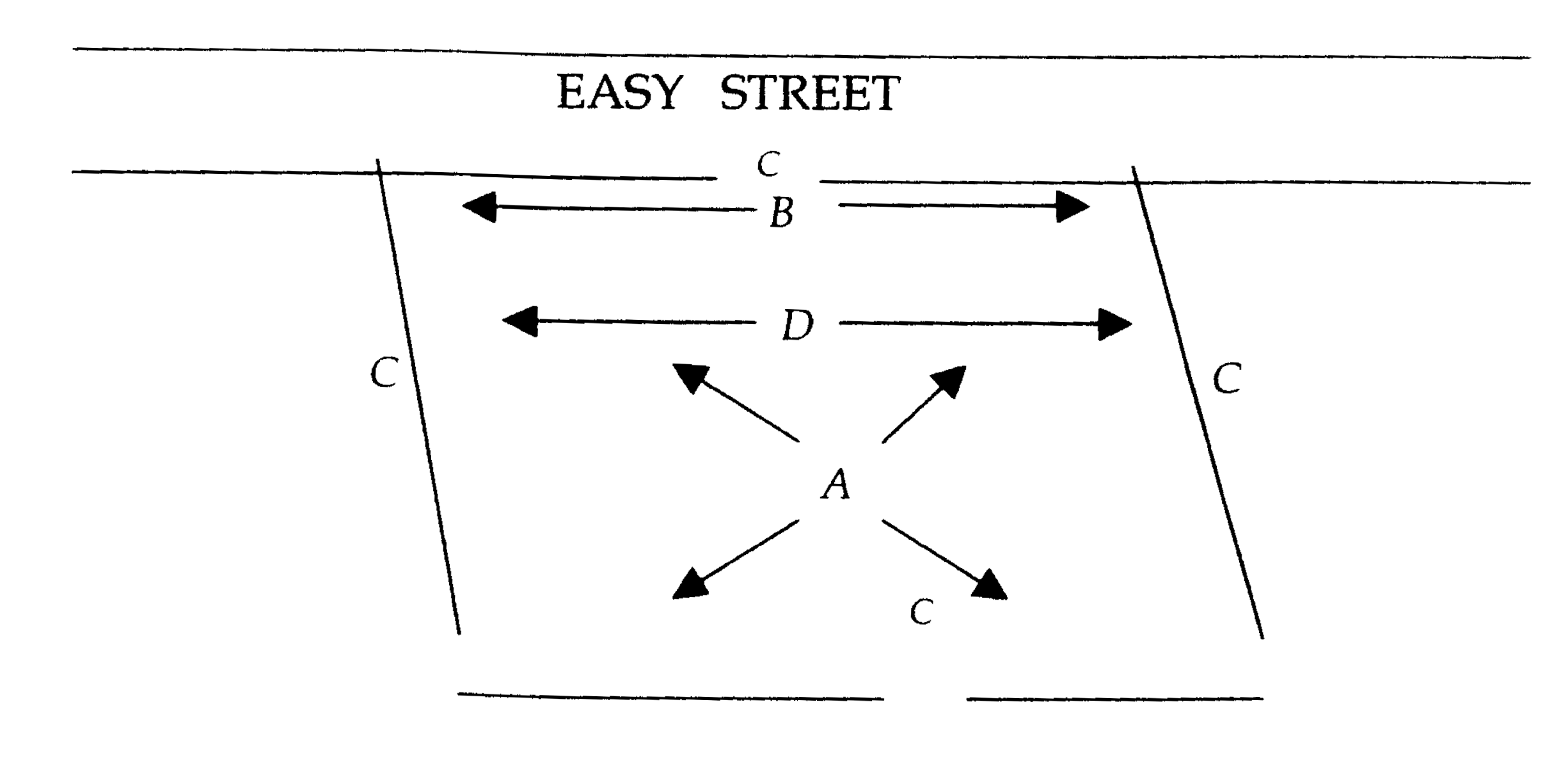
2-54.1. Lot area: The total surface of area of land included within the lot lines but excluding street right-of-ways. (See "A" in figure.)
2-54.2. Lot corner: A lot situated at the intersection of two streets, the interior angle of such intersection not exceeding 135 degrees.
2-54.3. Lot coverage: The percentage of contiguous land on a lot that can be covered with impervious material.
2-54.4. Lot frontage: The distance for which the boundary line of the lot and the street right-of-way line are coincident. (See "B" In figure.)
2-54.5. Lot lines: The boundary dividing a given lot from the street, an alley or adjacent lots. (See "C" in figure.)
2-54.6. Lot width: The width of a lot at the building setback line measured at right angles to its depth. (See "D" in figure.)
2-54.7. Lot of record: A lot, the boundaries of which are filed as legal record as of the date of the incorporation of the Town of Pawleys Island and shown on the official Town map (See figure 2-A). Such a lot is not subject to the ordinances of the Town of Pawleys Island regarding lot location, accessibility, size, width or area. A lot of record shall not lose its status as such by reason of transfer of title. However, any structure constructed on a lot of record is subject to the ordinances of the town and any structure which replaces an existing structure on a lot of record must adhere to the ordinances in force.
FIGURE 2-A
OFFICIAL TOWN MAP
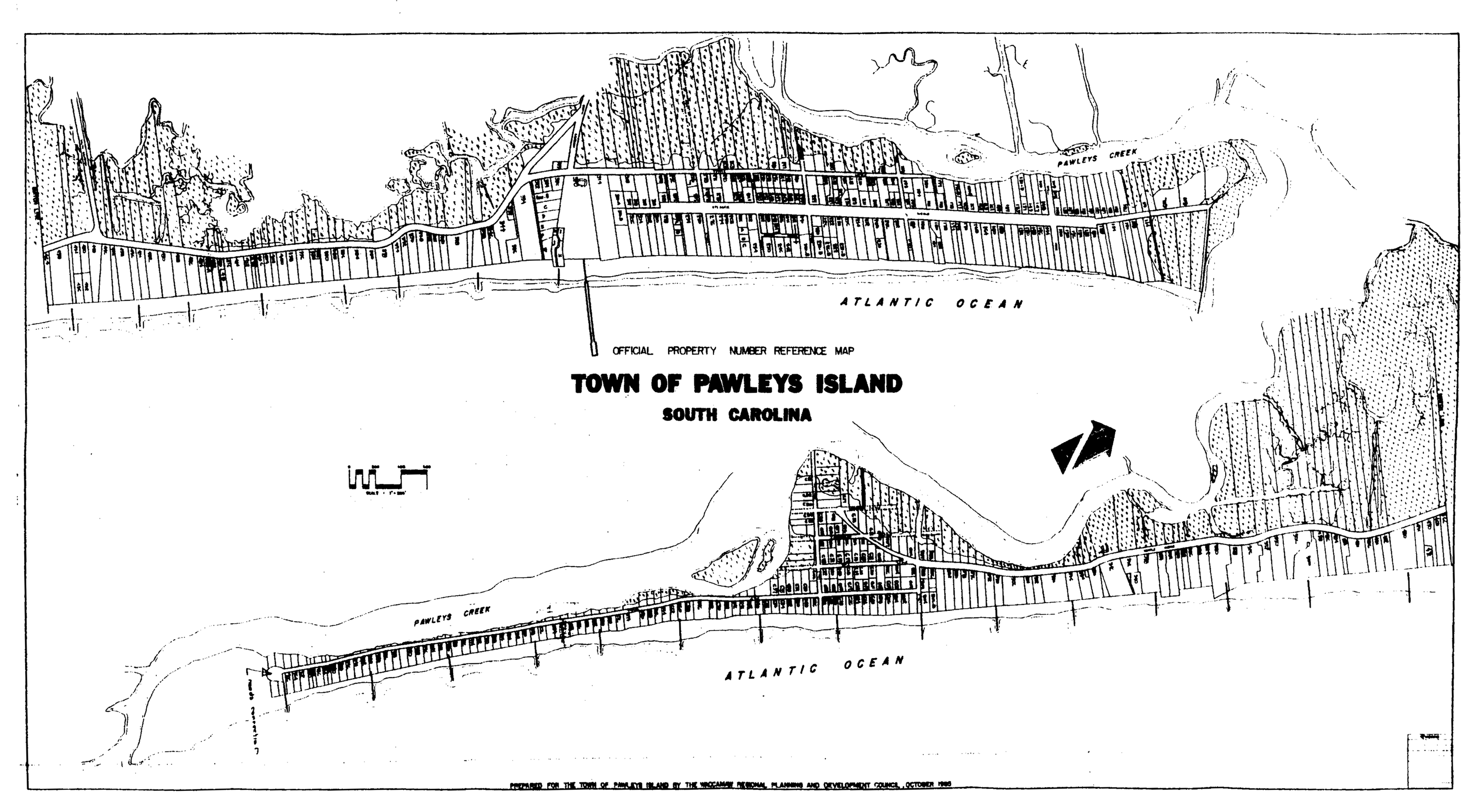
Note— This map is a reduced copy of the Official Town Map, which is kept in the Town Hall by the building official. For references involving enforcement actions, the Official Town Map should be utilized.
2-54.8. Buildable lot: To determine that a lot meets minimum square footage requirements as stated in sections 3-2.2(C) and 3-2.3(C), it will be defined as "all property encompassed within the boundaries of the lot lines as shown on a registered plat of the property."
2-55. Low profile luminaire: Light fixture set on a base which raises the source of the light no higher than 48 inches off the ground, and designed in such a way that light is directed downward from a hooded light source.
2-55.5. Lowest adjacent grade (LAG): LAG is an elevation of the lowest ground surface that touches any structurally attached deck support, exterior walls of a building or proposed building walls.
2-56. Lowest floor: The lowest floor of the lowest enclosed area (including basement). An unfinished or flood-resistant enclosure, usable solely for parking of vehicles, building access or storage in an area other than a basement area is not considered a building's lowest floor; provided, that such enclosure is not built so as to render the structure in violation of the applicable non-elevation design requirements of this Unified Development Code.
2-56.3. Manufactured home: A structure, transportable in one or more sections, which is built on a permanent chassis and designed to be used with or without a permanent foundation when connected to the required utilities. The term "manufactured home" does not include a "recreational vehicle". Manufactured homes are prohibited in town.
2-56.6. Manufactured home park or subdivision: A parcel (or contiguous parcels) of land divided into two or more manufactured home lots for rent or sale. Manufactured home parks or subdivisions are prohibited in the town.
2-57. Mean sea level: Means, for the purpose of this Unified Development Code, the National Geodetic Vertical Datum (NGVD) of 1929, North American Vertical Datum (NAVO) of 1988, or other datum, to which the base flood elevations shown on a community's flood insurance rate maps (FIRM) are shown.
2-58. Mobile home: A structure, transportable in one or more sections, which is eight feet or more in width and built on a permanent chassis and designed to be used as a dwelling unit with or without a permanent foundation when connected to the required utilities and includes the plumbing, heating, air-conditioning and electrical systems contained therein. Mobile homes are prohibited within the town limits.
2-59. Modular home: A structure manufactured off-site, transportable in sections, designed to be used as a dwelling unit to be set on a permanent foundation, including electrical, plumbing and mechanical systems and constructed under the supervision of, and certified by, the 2000 IRC International Code, as amended in accordance with the 2000 IRC International Code, as amended for residential construction. Modular construction does not include a permanent chassis and is not designed for ready removal to another site.
2-60. National Geodetic Vertical Datum (NGVD) of 1929: As corrected in 1929, elevation reference points set by the National Geodetic Survey based on mean sea level.
2-61. New construction: Structure for which the start of construction commenced on or after May 9, 2023. The term also includes any subsequent improvements to such structure.
2-62. New development: Shall include new construction and remodeling of existing structures when such remodeling includes alteration of exterior lighting.
2-62.5. New manufactured home park or subdivision: A manufactured home park or subdivision for which the construction of facilities for servicing the lots on which the manufactured homes are to be affixed (including at a minimum, the installation of utilities, the construction of streets, and either final site grading or the pouring of concrete slabs). There are no existing manufactured home parks or subdivisions in the town. New manufactured home parks or subdivisions are prohibited in the town.
2-63Nonconformity(ies): Any aspect of a lot, site feature, structure, or use, or any combination thereof, which was lawfully established but which does not comply with the terms of this Unified Development Code.
2-63.1 Nonconforming lot: A lot, designated on a duly recorded subdivision plat, or duly recorded deed, or by other lawful means, that complied with the zoning and development standards applicable to it at the time of its creation, but which no longer complies with the minimum area, lot width, frontage, or other standards now applicable to it under the terms of this Unified Development Code.
2-63.2 Nonconforming site feature: A characteristic of a lot, structure, or use, such as illumination, parking, impervious area, landscaping, or a similar appurtenance, that was lawfully established but which no longer complies with the standards applicable to it under the terms of this Unified Development Code.
2-63.3 Nonconforming structure: A building or structure that was lawfully established but which no longer complies the size, coverage, setback, building height, or other dimensional standards applicable to it under the terms of this Unified Development Code.
2-63.4 Nonconforming use: A use that was lawfully established but which is no longer allowed by the use regulations of the zoning district in which it is located. The term nonconforming use shall include all onsite buildings and structures associated with said use.
2-63.A. Non-conversion agreement: An agreement signed by the owner as a condition of a certificate of occupancy. The owner must agree to not alter the enclosed area beneath the lowest floor at a later date as to violate the building code or unified development ordinance requirements. The agreement shall be binding upon heirs, grantees, successors and assigns of parties hereto and shall constitute a covenant running with the structure being constructed under said permit. The agreement shall be recorded with the Georgetown County Registrar of Deeds office prior to obtaining a certificate of occupancy inspection.
2-63.B. North American Vertical Datum (NAVO) of 1988: Vertical control, as corrected in 1988, used as the reference datum on flood insurance rate maps.
2-64. Not habitable: An area which shall have no finished walls, ceilings or floors. It also shall have no electrical outlets (except area lighting), no plumbing of any kind, and no heating/air conditioning outlets. There shall be no amenities for habitation.
2-65. OCRM: This acronym indicates the Office of Ocean and Coastal Resource Management within the state Department of Health and Environmental Control.
2-66. Parking space: An off-street space available for parking one motor vehicle and having an area not less than two hundred square feet exclusive of passageways and driveways giving access thereto and having direct access to a street or alley.
2-67. Planned development: A planned residential development, professionally designed as a unit and approved by the Town of Pawleys Island Planning Commission and Town Council. New planned developments are prohibited.
2-68. Planning commission: The Town of Pawleys Island Planning Commission.
2-69. Plat: A map, plan or layout indicating the location and boundaries of individual properties.
2-70. Pole lighting: Light fixture set on a base or pole which raises the source of the light higher than 48 inches off the ground.
2-71. Primary frontal dune: A continuous or nearly continuous mound or ridge of sand with relatively steep seaward and landward slopes and subject to erosion and overtopping from high tides and waves during coastal storms. The inland limit of the primary frontal dune occurs at the point where there is a distinct change from a relatively steep slope to a relatively mild slope.
2-71.5. Protected tree: A hardwood tree (including oaks, maples, cypress, sweet gum, hickory, cedar, magnolia, etc.) having five inch DBH or greater; an ornamental tree (including hollies, redbuds, dogwoods, etc.) having three-inch DBH or greater; and pines having ten-inch DBH or greater.
2-72. Recreational vehicle: A vehicle which is:
(a)
Built on a single chassis;
(b)
400 square feet or less when measured at the largest horizontal projection;
(c)
Designed to be self-propelled or permanently towable by a light duty truck;
(d)
Designed primarily not for use as a permanent dwelling, but as a temporary living quarters for recreational, camping, travel or seasonal use; and
(e)
For the purposes of floodplain management a recreational vehicle is defined as but not limited to a camper, motor home, travel trailer, and/or similar.
2-72.5. Repetitive loss: A building covered by a contract for flood insurance that has incurred flood-related damages on two occasions during a ten-year period ending on the date of the event for which a second claim is made, in which the cost of repairing the flood damage, on the average, equaled or exceeded 25 percent of the market value of the building at the time of each such flood event.
2-73. Right-of-way: Access over or across property for a specific purpose or purposes.
2-74. Salt marsh critical line: A line delineating all areas which are at or below mean high tide and coastal wetlands, mudflats, and similar areas that are contiguous or adjacent to coastal waters and are an integral part of the estuarine systems involved. Coastal wetlands include marshes, mudflats, and shallows and means those areas periodically inundated by saline waters whether or not the saline waters reach the area naturally or through artificial watercourses and are those areas that are normally characterized by the prevalence of saline water vegetation capable of growth and reproduction; provided, however, nothing in this definition shall apply to wetland areas that are not an integral part of an estuarine system. Further, until such time as the exact geographic extent of this definition can be scientifically determined, the South Carolina Department of Health and Environmental Control, Office of Ocean and Coastal Resource Management shall have the authority to designate its geographic extent. Further, S.C. Department of Health and Environmental Control, Office of Ocean and Coastal Resource Management's approval of a salt marsh critical line shall be valid for a minimum period of three years from the date of delineation.
2-75. Sand dunes: Any accumulation of sand in ridges or mounds landward of the beach in VE zones whether formed by natural or manmade forces.
2-75.5. Section 1316 of the National Flood insurance Act of 1968: The act provides that no new flood insurance shall be provided for any property found by the Federal Emergency Management Agency to have been declared by a state or local authority to be in violation of state or local ordinances.
2-76. Sewer, sanitary: A sewage collection, treatment and disposal system of a type approved by the South Carolina Department of Health and Environmental Control (DHEC).
2-77. Sewer, storm: A collection and disposal system for the control of storm drainage.
2-78. Shading coefficient: A coefficient expressing that percentage of the incident radiation which passes through the window as heat.
2-79. Shore protection line: That line which is drawn by the Pawleys Island Planning Commission and the S.C. Department of Health and Environmental Control, Office of Ocean and Coastal Resource Management on the aerial photomap of Pawleys Island, showing the seaward limit of construction. This aerial photomap is hereby adopted and may be found as figure 2-B.
SHORE PROTECTION LINE MAP
FIGURE 2-B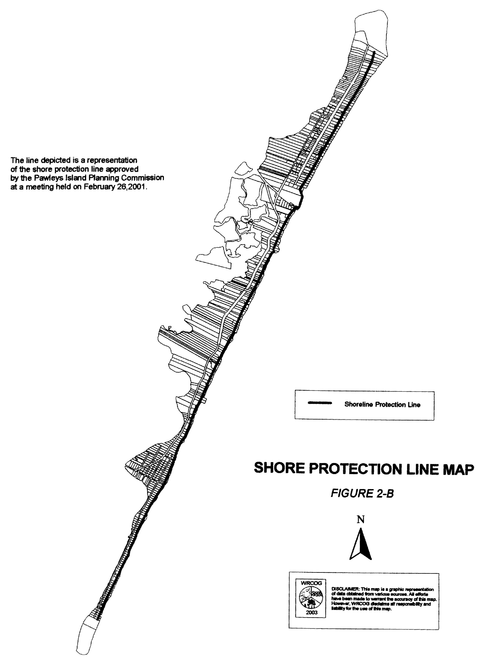
2-80. Sign: Any device designed to inform or attract the attention of persons not on the premises on which the sign is located. Except for Dune protection and the Town of Pawleys Island safety information signs, no signage is allowed forward/eastward of the shore protection line. The usage and types of signs allowed in the town are listed in article 11 of the Unified Development Ordinance.
2-80.1. Sign definitions:
(A)
Sign, surface area: For the purpose of determining surface area of a sign, the area of a sign, the area of a sign shall be computed as including the entire area within a parallelogram, triangle, circle or semi-circle comprising all the displayed matter, exclusive of frames or supports. In the case of back-to-back or V-type signs, the largest of the two display surfaces shall be used to compute surface area.
(B)
Sign, on-site: A sign relating in its subject matter to the premises on which it is located.
(C)
Sign, illuminated: Any sign which employs internal artificial illumination.
(D)
Sign, abandoned: Any sign or part thereof that is located on property which becomes vacant or abandoned for period of one year (365 consecutive days) or any sign which pertains to a time, activity or purpose which no longer applies; shall be deemed to be abandoned and shall be removed.
2-81. Solar screen: Screens which are fixed installations and permanently project shade over the entire glass area of the window. The screens must be installed outside of the glass and must:
1)
Have a shading coefficient of .45 or less; and
2)
Carry a minimum five-year warranty; and
3)
Must have performance claims supported by approved testing procedures and documentation.
2-82. Solid waste and/or refuse: Any garbage, refuse, sludge from a waste treatment facility, water supply plant, or air pollution control facility and other discarded material, including solid, liquid, semisolid or contained gaseous material resulting from industrial, commercial, mining, and agricultural operations and from community activities. This term does not include solid or dissolved materials in domestic sewage, or solid or dissolved materials in irrigation return flows or industrial discharges which are point sources subject to state or federal permits.
2-82.5. Stable natural vegetation: The first place on the oceanfront where plants such as sea oats hold sand in place.
2-83. Start of construction: For other than new construction or substantial improvements under the Coastal Barrier Resources Act (P.L. 97-348), includes substantial improvement, and means the date the building permit was issued, provided the actual start of construction, repair, reconstruction, rehabilitation, addition, or improvement was within 180 days of the permit date. The actual start means the first placement of permanent construction of a structure (including a manufactured home) on a site, such as the pouring of slabs or footings, installation of piles, construction of columns, or any work beyond the stage of excavation or the placement of a manufactured home on a foundation. Permanent construction does not include land preparation, such as clearing, grading, and filling; nor does it include the installation of streets and/or walkways; nor does it include excavation for footings, piers, or foundations, or the erection of temporary forms; nor does it include the installation on the property of accessory buildings, such as garages or sheds not occupied as dwelling units or not part of the main structure. For a substantial improvement, the actual start of construction means the first alteration of any wall, ceiling, floor, or other structural part of the building, whether or not that alteration affects the external dimensions of the building.
2-84. State DHEC: The South Carolina Department of Health and Environmental Control.
2-85. Street: Any public way (excluding public beach access) set aside for public travel. The word "street" shall include the words "road," "highway" and "thoroughfare." New streets are prohibited in the Town of Pawleys Island.
2-85.1. Street, minor: A street used primarily for access to abutting properties.
(A)
Street, alley: A minor street used for services access to the back or side of properties otherwise abutting on a street.
(B)
Street, cul-de-sac: A minor street with only one outlet, sometimes called a "dead-end" street.
2-86. Structure: A walled and roofed building that is principally above ground, as well as a gas or liquid storage tank, or other manmade facilities or infrastructures.
2-87. Subdivider: Any person, firm, corporation or other legal entity subdividing land within the jurisdiction of this Unified Development Code.
2-88. Subdivision: The division of a tract, parcel, or lot into two or more lots, building sites or other divisions for the purpose, whether immediate or future, of sale, legacy or building development.
2-89. Substantial damage: Damage of any origin sustained by a structure whereby the cost of restoring the structure to it's before damaged condition would equal or exceed 50 percent of the market value of the structure before the damage occurred. Such repairs may be undertaken successively, and their costs counted cumulatively. Please refer to the definition of "substantial improvement".
2-90. Substantial improvement: Any repair, reconstruction, rehabilitation, addition, or other improvement of a structure, the cost of which equals or exceeds 50 percent of the market value of the structure before the start of construction of the improvement. This term includes structures that have incurred repetitive loss or substantial damage, regardless of the actual repair work performed. The term does not, however, include either:
a)
Any project of improvement to a structure to correct existing violations of state or local health, sanitary, or safety code specifications which have been identified by the local code enforcement official and which are the minimum necessary to assure safe living conditions or,
b)
Any alteration of a historic structure, provided that the alteration will not preclude the structure's continued designation as a historic structure.
Permits shall be cumulative for a period of five years. If the improvement project is conducted in phases, the total of all costs associated with each phase, beginning with the issuance of the first permit, shall be utilized to determine whether "substantial improvement" will occur.
2-91. Surveyor: A registered land surveyor in good standing with the South Carolina Board of Engineering Examiners.
2-92. Tinted or filmed glass: Window glass which has been covered with window tint or film such that the material has:
1)
A shading coefficient of .45 or less; and
2)
A minimum five year warranty; and
3)
Adhesive as an integral part; and
4)
Performance claims which are supported by approved testing procedures and documentation.
2-93.1. Top plate: The uppermost horizontal structural member of the exterior walls of a building, on which the rafters or roof trusses rest.
2-93.2. Trash: The word "trash" is hereby defined to mean any nonputrescible, combustible, or noncombustible item of solid waste that will not fit properly into an approved garbage container.
2-94. Unauthorized accumulation of solid waste: The storage or accumulation on any premises of solid wastes, as defined herein, in such a manner as to create unsanitary conditions, fire hazards, offensive or obnoxious odors, insect breeding places, harboring places for rodents, or to be a nuisance to the public or any way adversely affect the health, safety, sanitation, and welfare of the public.
2-95. Use: The purpose for which a piece of land or its buildings is designed, arranged or intended or for which it is occupied or maintained.
2-95.1. Use, principal: The primary purpose for which a lot is occupied and/or used.
2-95.2. Use, accessory: A use customarily incidental, appropriate and subordinate to the principal use of land and located on the same lot therewith.
2-96. Vacation time sharing plan: Any arrangement, plan or similar device, whether by tenancy in common, sale, deed, or by other means, which is subject to supplemental agreement or contract for use of the time share unit, whereby the purchaser receives an undivided ownership interest in and the right to use accommodations or facilities or both, for specific period of time during any given year, but not necessarily for consecutive years, which extends for a period of more than one year, as regulated under S.C. Code 1976, § 27-32-10 et seq. It shall include, but is not limited to, interval ownership. Such vacation time sharing plans are prohibited on Pawleys Island. The advertising of vacation time sharing plans or ownership shall be strictly prohibited. A violation of the provisions shall result in a civil penalty. Each violation shall carry a fine of up to $500.00.
2-97. Variance: A grant of relief from a term or terms of this Unified Development Code.
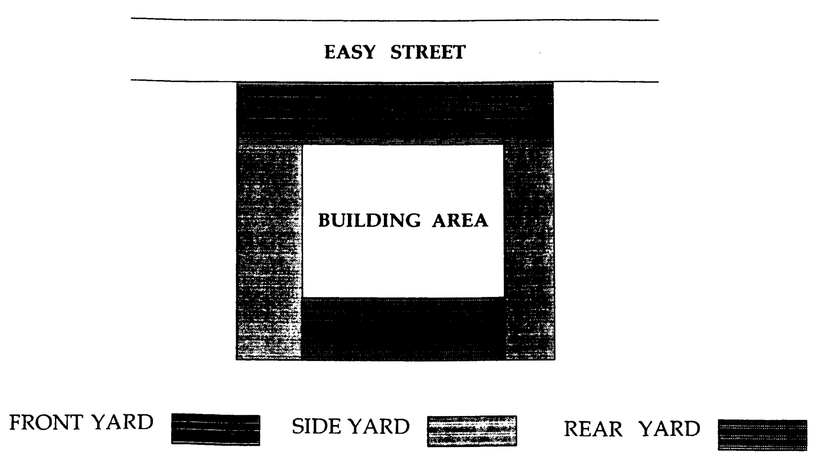
2-98. Yard: An open space on the same lot with the principal building, open, unoccupied and unobstructed by buildings from the ground to the sky except as otherwise provided in this Unified Development Code.
2-98.1. Yard, front: The side of the lot parallel with the public street that contains the sequential street address extending across the full width of the lot, the depth of which is the horizontal distance between the street and the front building line.
2-98.2 Yard, side: A yard extending along the side lot line from the front yard to the rear lot line and lying between the side lot line and the side outside wall of structure.
2-98.3. Yard, rear: The yard extending across the rear of the lot between inner side yard lines.
2-99. Violation: The failure of a structure or other development to be fully compliant with these regulations.
2-100. Zoning administrator: An individual or agent or agency as designated from time to time by the town council.
(Ord. No. 2003-29, §§ 2-1—2-97.3, 12-8-2003; Ord. No. 2005-08, § 2-16, 12-12-2005; Ord. No. 2005-10, § 2-10.1, 12-12-2005; Ord. No. 2007-02, § 2-47, 1-8-2007; Ord. No. 2007-06, § 2-47, 4-9-2007; Ord. No. 2007-13, § 2-92, 11-12-2007; Ord. No. 2008-10, §§ 2-96, 2-96.1, 8-11-2008; Ord. No. 2008-11, §§ 2-9, 2-98, 2-99, 9-8-2008; Ord. of 11-2009; Ord. No. 2009-18, art. 2, 12-7-2009; Ord. No. 2009-19, §§ 2-99—2-99.3, 12-7-2009; Ord. No. 2012-4, 5-14-2012; Ord. No. 2012-11, 9-10-2012; Ord. No. 2013-04, 3-11-2013; Ord. No. 2014-02, 5-12-2014; Ord. No. 2014-04, 7-14-2014; Ord. No. 2014-06, 9-8-2014; Ord. No. 2014-09, 11-10-2014; Ord. No. 2014-10, 11-10-2014; Ord. No. 2015-04, 4-13-2015; Ord. No. 2015-06, 7-20-2015; Ord. No. 2016, 8-8-2016; Ord. No. 2017-06, 7-10-2017; Ord. No. 2018-04, 6-11-2018; Ord. No. 2023-04, 4-10-2023; Ord. No. 2023-05, 5-2-2023)