
Pinal County Unincorporated
City Zoning Code
City Zoning Code
CHAPTER 2
215.- ADDRESSING AND STREET NAMING
2.215.010.- Purpose.
This chapter is to provide for the uniform assignment of property numbers on residences, public buildings, and businesses along public and private streets or roads; to provide for the naming and renaming of streets or roads; and to provide addressing for emergency services responding to 911 calls.
(Ord. No. 011812-ZO-PZ-C-007-10, § 24)
2.215.020. - Applicability.
This chapter shall apply to all unincorporated and nonreservation lands within the county.
(Ord. No. 011812-ZO-PZ-C-007-10, § 24)
2.215.030. - Definitions and abbreviations.
The following words, terms and phrases, when used in this chapter, shall have the meaning ascribed to them below:
Addressing baseline means two imaginary lines, one running north and south, and one running east and west intersecting at a zero point.
Avenue (Ave.) means thoroughfares that run in any direction; a common or default suffix.
Boulevard (Blvd.) means a broad thoroughfare that acts as a collector and often has a median.
Circle (Cir.) means a curvilinear thoroughfare that returns to its starting point.
Collector means a street that provides the traffic movement within neighborhoods between major thoroughfares and local thoroughfares, and for direct access to abutting property.
Court (Ct.) means a relatively short, uninterrupted dead-end street such as a cul-de-sac.
Drive (Dr.) means winding, diagonal, curvilinear, meandering, or other types of thoroughfares not otherwise defined.
Grid lines means imaginary lines constructed perpendicular and parallel to addressing baselines used to define address numbers.
Highway (Hwy.) means designated county highway, state route, state highway or federal access route.
Lane (Ln.) means a local thoroughfare.
Loop (Loop) means a thoroughfare that begins and ends on the same side of the originating street but not in the same place.
Parkway (Pkwy.) means a special scenic route or park drive that is not a local thoroughfare.
Place (Pl.) means a cul-de-sac or permanent dead-end road or a local thoroughfare in a subdivision.
Prefix, directional, means a one-character compass point preceding a street name that indicates a direction. For example: north (N), south (S), east (E) and west (W). See PCDSC 2.215.050(D).
Road (Rd.) means thoroughfares that run in any direction; a common or default suffix.
Street (St.) means thoroughfares that run in any direction; a common or default suffix.
Suffix means a word following a street name that indicates the street type. See PCDSC 2.215.050(E).
Thoroughfare means a generic term for providing for the movement of traffic and access to various land uses.
Trail (Trl.) means a winding thoroughfare.
Way (Way) means a local thoroughfare.
(Ord. No. 011812-ZO-PZ-C-007-10, § 24)
2.215.040. - Assigning numbers to properties.
A.
Property numbers for dwelling units, places of business, and public and private utilities and other properties along streets as necessary for permitting and/or safety purposes shall be assigned by the planning and development department in accordance with provisions outlined herein.
B.
Property numbering shall be sequential
C.
The county has five addressing grids known as Pinal County, Apache Junction/Gold Canyon, Queen Valley, San Manuel, and Oracle that are hereby established collectively as the Pinal County grid system. Within each addressing grid, except for the San Manuel addressing grid, there is an established zero point and prefix designation. Specific addressing grid and zero points are shown in illustration numbers 1 through 4 and the San Manuel addressing grid is shown in illustration number 5.
D.
In addressing grids with zero points, all streets running north perpendicular to the east-west zero point baselines shall have a north prefix directional. All streets running south perpendicular to the east-west zero point baseline shall have a south prefix directional. All streets running east perpendicular to the north-south zero point baseline shall have an east prefix directional. All streets running west perpendicular to the north-south zero point baseline shall have a west prefix directional.
The Pinal County zero point is located at Eleven Mile Corner Road and Highway 287.
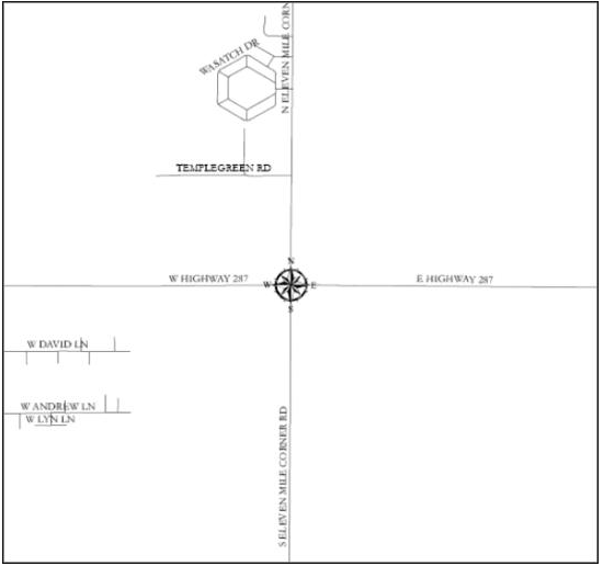
Illustration No. 1
The Apache Junction/Gold Canyon zero point is at Idaho Road and Junction Street.
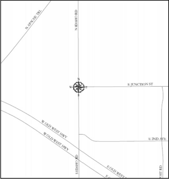
Illustration No. 2
The Queen Valley zero point is at Kirk Drive and Sharon Drive.
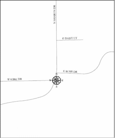
Illustration No. 3
The Oracle zero point is at the southeast corner of section 35, Township 09S, Range 15E.
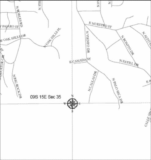
Illustration No. 4
San Manuel does not have a zero point. The existing San Manuel addressing grid remains in place from the west of, but not including, the present Veterans Memorial Boulevard and applies to the established San Manuel townsite.
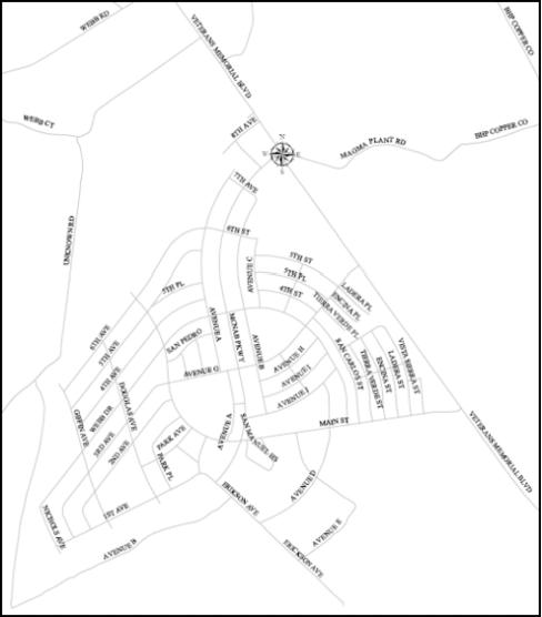
Illustration No. 5
E.
Even numbers shall always be assigned on the north and west sides of streets and odd numbers shall always be assigned on the south and east sides of streets. Once assigned, numbers shall not be arbitrarily changed without the approval of the planning and development department.
F.
The numbering system shall allow for expansion to accommodate future growth in the area.
G.
Numbering shall be according to the applicable Pinal County grid system.
H.
Multiple dwelling units.
1.
Numbers shall be assigned to the property where a driveway joins the street; this becomes the street address of all units which face upon that interior court. Separate internal units of condominiums and apartments shall be designated with sub-numbers or letters, not individual property numbers.
2.
Mobile home parks shall be treated like other multifamily developments. The property shall be assigned one number, and each mobile home space shall receive numerical designations such as Sp. 1, Sp. 2, Sp. 3, etc. However, if the development is a mobile home subdivision built in conformance with subdivision regulations, the properties shall be addressed as individual residences.
I.
Business addressing. Businesses shall be numbered with the main building receiving one address and each individual office being assigned suite numbers as secondary location indicators. In business condo plats, lots may be addressed per lot, per building or per development with individual suite numbers assigned as secondary location indicators.
J.
Numbering when streets change direction. If a street changes direction drastically and for a substantial length, the numbering may be changed to reflect the orientation with a different prefix directional and/or name.
K.
Diagonal streets. The general principle to apply when numbering diagonal streets is to treat the street as either a north-south or an east-west street based on the greatest distance covered in any specific direction.
L.
Corner lots. When assigning a number to a building on a corner lot, assign a number from the street upon which the main entrance faces for a business or assign a number from the street from which the driveway enters for a residence. If a corner building has two entrances which both look like main entrances, the decision is based on the general site layout and driveway entrance.
M.
Duplex buildings and houses on interior lots.
1.
One number shall be assigned to a duplex building with sub-numbers or letters for each internal unit.
2.
Separate numbers shall be assigned for single-family dwellings in the rear of other single-family dwellings.
3.
If a commercial enterprise that is part of a residence has a separate entrance from the street, it may also be assigned a separate number. If there is a rear entrance or a hidden structure, a post should display the number on the path leading to the entrance, even if it is reached through another structure.
N.
Numbering on circle streets. Odd-ending digits will be assigned in a consecutive and corresponding manner to the properties on the outside of the circle while even-ending digits will be assigned in a consecutive and corresponding manner to the properties on the inside of the circle.
O.
Annexation. If an area is annexed by a municipality, the existing addresses will then be the responsibility of the municipality.
(Ord. No. 011812-ZO-PZ-C-007-10, § 24)
2.215.050. - Street names.
The following general principles of street naming shall be used when naming or renaming streets within the unincorporated area of the county:
A.
Objective. Names shall be easy to pronounce and easy to spell so the public, and children in particular, can recite the name in an emergency situation.
B.
Unacceptable street names. Unacceptable street names are:
1.
Numerical names (1st, 2nd, etc.);
2.
Letters of the alphabet (A, B, C, etc.);
3.
Copyrighted and trademark names;
4.
Famous names;
5.
Complicated words;
6.
Unconventional spellings;
7.
Duplicates particularly within the same postal delivery or emergency response area;
8.
Street names pronounced similarly;
9.
Names with 22 or more letters and spaces including the suffix abbreviation within the full address format (i.e., Spectacular Mountain Views = 26 characters with spaces); and
10.
Directional name or street suffix cannot be used in the street name; example (a): E South Haven St. must be E Haven St.; example (b): E Memory Trail Dr. must be E Memory Dr.
C.
Complete name. A complete name shall consist of no more than four words, including the appropriate mandatory prefix directional and any optional suffix. Examples:
1.
W Twin Butte Road: prefix directional (1 word); primary (2 words); suffix (1 word).
2.
S San Mateo Castro: prefix directional (1 word); primary (3 words).
D.
Prefix, directional. All street names shall begin with one directional prefix of north, south, east, or west. Abbreviations shall be: N, S, E, or W. Combinations of directions are not acceptable. Example: Northwest Sierra Circle.
E.
Suffix. Suffix types should reflect the character of the roadway. Lane, drive, place, and way are minor roadways. Road, drive, street, and avenue may be local thoroughfares. Road, avenue, street, boulevard, and parkway may be major arterial streets. No residential lots shall front a boulevard or parkway.
F.
Name duplication. Similar sounding names are considered to be duplications regardless of spelling. No duplication of names for new roadways is permitted within the projected service area of the U.S. Postal Service or of local public agencies such as fire and police departments.
G.
Continuity. A continuous street, or one proposed to be continuous, should bear the same name and suffix through its alignment except in the case of a cul-de-sac which might be identified as a court.
H.
Corrections.
1.
The planning and development department shall correct an address number or street prefix directional not in conformance with this chapter when the change is necessary to prevent confusion for emergency services responding to 911 calls.
2.
Notice of the change shall be mailed by the planning and development department to all owners of the property whose address has changed.
3.
Notice of the change shall also be transmitted by the planning and development department to the U.S. Postal Service and the 911 system.
(Ord. No. 011812-ZO-PZ-C-007-10, § 24)
2.215.060. - Renaming existing streets.
A.
The proposed renaming of a street may be initiated by:
1.
The supervisors; or
2.
A citizen's petition.
a.
The petition must contain the following:
i.
Signatures of at least 51 percent of the property owners with frontage on or addresses assigned from the subject street of the proposed name change;
ii.
A reason why the name change is needed (example: eliminate duplicate name, help improve emergency services to the area);
iii.
The names, addresses, assessor's parcel numbers and signatures of each property owner signing the petition;
iv.
Existing name and proposed name with an alternative name;
v.
Description of the beginning and end of the street subject to the proposed name change; and
vi.
Identify whether the street is public or private.
b.
Each parcel of real property is entitled to one vote.
c.
The petition shall be accompanied by the following:
i.
The applicable filing fee.
ii.
A list of names and addresses of property owners with frontage on or addresses assigned from the subject street of the proposed name change and of service and emergency organizations (for example: fire, police, post office) that service that area.
iii.
A statement that the existing street is or is not named after a person, place or event of historical significance.
iv.
A statement as to whether the proposed street name is for a person, place or event of historical significance.
d.
The petition must be filed with the planning and development department together with any documentation the petitioners can provide as to when and how the road, which is the subject of the proposed name change, was created.
B.
For proposed name changes to an existing street or right-of-way, the planning and development department shall originate a map showing the location of the street and the existing name and proposed name change.
C.
The supervisors shall hold at least one public hearing on the proposed name change and proposed alternative name change. Notice of the public hearing and the map shall be given as follows:
1.
By publication at least once in a newspaper of general circulation in the area of the proposed name change. If the subject area does not have a newspaper of general circulation, then publish in a newspaper of general circulation in the adjacent area or the county seat.
2.
By posting at reasonable intervals, as determined by the planning and development department, along the subject street of the proposed name change at least 15 calendar days before the date of the public hearing;
3.
By first class mail to each property owner, as shown on the assessment of the property, with frontage property or address assigned from the subject street of the proposed name change.
D.
Notice of the public hearing shall include the location of the proposed name change; the existing name; proposed name change; proposed alternative name change; the date, time, place and location of the public hearing; and the time period and location for filing a letter of objection or support.
E.
If the supervisors approve the name change, the planning and development department will mail out a written notice to the residents/property owners affected by the name change stating the new address and enclosing a copy of PCDSC 2.215.080, Posting of property numbers.
F.
After approval of a name change by the board, a subsequent proposed name change for that specific street shall not be considered for a period of five years from the date of the supervisors' approval.
(Ord. No. 011812-ZO-PZ-C-007-10, § 24)
2.215.070. - Street name signs.
A.
The public works department shall prepare, place and maintain street signs for public streets and at intersections of private ways and public streets outside of subdivisions.
B.
The subdivider shall be responsible for purchase and installation of all street name signs within a subdivision, including intersections with perimeter streets. All street name signs shall conform to county standards and shall be furnished and installed at no cost to the county at locations as shown on the approved plans.
C.
Purchase of the replacement signs for private streets within a subdivision shall be the responsibility of the homeowner's association.
D.
All street name signs, except those specified in subsections (A), (B), and (C) of this section, may be purchased from the public works department by the individual who requested the approved street name. All street name signs and installation of such signs must conform to county standards and requirements. Fees for street name signs purchased from and/or installed by the public works department may be assessed pursuant to A.R.S. § 11-251.08(A).
(Ord. No. 011812-ZO-PZ-C-007-10, § 24)
2.215.080. - Posting of property numbers.
Methods and characteristics for posting assigned property numbers are as follows:
A.
Property numbers shall be posted on the lot or parcel at the time of construction and are to be visible from and oriented toward the street from which the address is taken.
B.
When a house or building is some distance from a road, or when the view of the house or building is obstructed, the property number shall be posted in a manner visible from the road.
C.
On a corner lot, the property number shall face the street named in the address.
D.
Numerals indicating the assigned address for each principal building or each front entrance to such building shall be posted in a manner as to be legible and distinguishable from the street in which the property is located.
E.
In case a principal building is occupied by more than one business or family dwelling unit (duplex), each separate front entrance shall post a building and unit number, suite or floor number, as applicable.
F.
Owner, occupant or person in charge shall post property numbers. Property numbers must be posted within 60 calendar days after receiving written notification of an assigned number.
G.
It shall be the duty of such owner, occupant or person in charge thereof upon posting the new number to remove any different number which might be mistaken for or confused with the number assigned to the structure by the planning and development department.
H.
If a property number is damaged, lost, or in any way destroyed, the current assigned number shall be replaced immediately by the owner, occupant or person in charge of the residence or building.
(Ord. No. 011812-ZO-PZ-C-007-10, § 24)