
Ponce Inlet City Zoning Code
ARTICLE 2
ZONING DISTRICTS
SECTION 2.1.- DISTRICTS AND OVERLAYS ESTABLISHED
The incorporated area of the Town of Ponce Inlet is divided into the zoning districts and overlay districts established below. The zoning district boundaries are shown on the official zoning map. The overlay districts maps are shown in this article. The official zoning map and the explanatory material on its face are incorporated in the LUDC by reference.
A.
Zoning districts.
B.
Overlay districts.
(Ord. No. 2018-12, § 2, 9-20-2018)
SECTION 2.4. - C (CONSERVATION)
A.
Purpose and intent. The conservation zoning district is intended to protect environmentally sensitive lands, coastal dunes, shorelines, and associated mangrove and salt water marsh communities, and preserves those conditions and characteristics which promote dune and shoreline stabilization, storm surge abatement, water quality maintenance, wildlife and marine resource habitats, and marine productivity. It intends to prevent urban development on lands that are unsafe for that use because of potential for erosion, flooding, wave run-up, inadequate accessibility, or other conditions.
B.
Permitted uses and structures. See section 2.40, Table 2-5 (Table of Permitted Uses).
C.
Dimensional requirements.
D.
Development permit review. A development permit application shall be submitted and reviewed pursuant to section 6.5.
SECTION 2.5. - R-1 (LOW DENSITY SINGLE-FAMILY)
A.
Purpose and intent. The low density single-family residential zoning district is intended to provide low-density residential developments on individual lots that are consistent with the character of existing or proposed residential neighborhoods.
B.
Permitted uses and structures. See section 2.40, Table 2-5 (Table of Permitted Uses).
C.
Dimensional requirements.
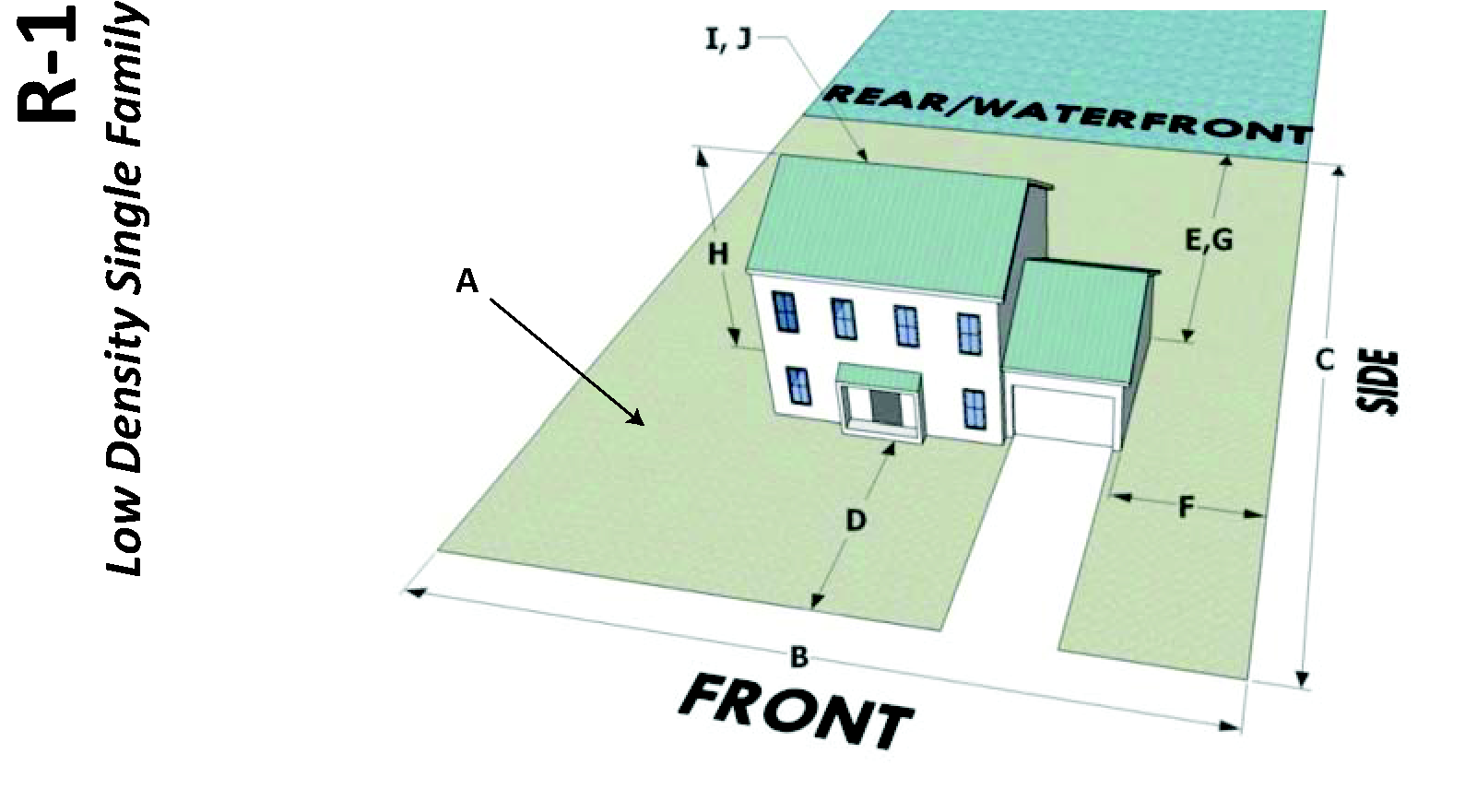
D.
Development permit review. A development permit application shall be submitted and reviewed pursuant to section 6.5.
(Ord. No. 2013-02, § 2, 3-21-2013; Ord. No. 2013-08, § 2(Exh. A), 6-20-2013)
SECTION 2.6. - R-2 (LOW-MEDIUM DENSITY SINGLE-FAMILY)
A.
Purpose and intent. The low-medium density single-family residential zoning district is intended to provide low-medium density residential developments on individual lots that are consistent with the character of existing or proposed residential neighborhoods.
B.
Permitted uses and structures. See section 2.40, Table 2-5 (Table of Permitted Uses).
C.
Dimensional requirements.
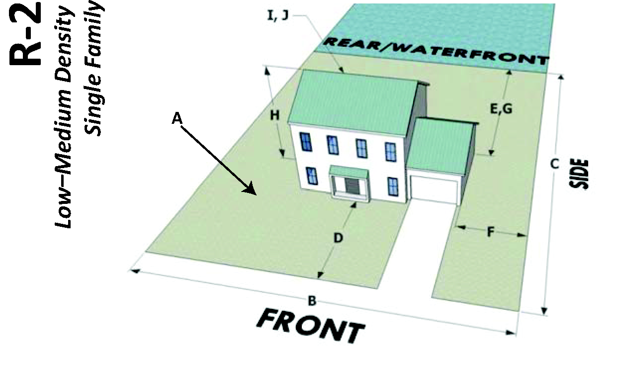
D.
Development permit review. A development permit application shall be submitted and reviewed pursuant to section 6.5.
E.
Construction on lots containing TIIF-deeded submerged lands.
1.
As part of any development application for structures within ten feet of a seawall, the property owner shall provide a signed and sealed report from a professional engineer, licensed in the State of Florida determining whether the stability and integrity of the seawall will be affected by the proposed construction and whether additional pilings or shorings will be required.
2.
Stormwater runoff from structures on the entire site shall be managed on the dry-land portion of the site.
3.
For all structures proposed to be constructed in the water, the applicant shall secure all necessary state and/or federal approvals (e.g. Florida DEP and Army Corp of Engineers) before commencing construction.
(Ord. No. 2013-02, § 3, 3-21-2013; Ord. No. 2013-08, § 2(Exh. A), 6-20-2013)
SECTION 2.7. - R-3 (MEDIUM DENSITY SINGLE-FAMILY)
A.
Purpose and intent. The medium density single-family residential zoning district is intended to provide small-lot single-family residential developments on individual lots that are consistent with the character of existing and future residential neighborhoods.
B.
Permitted uses and structures. See section 2.40, Table 2-5 (Table of Permitted Uses).
C.
Dimensional requirements.
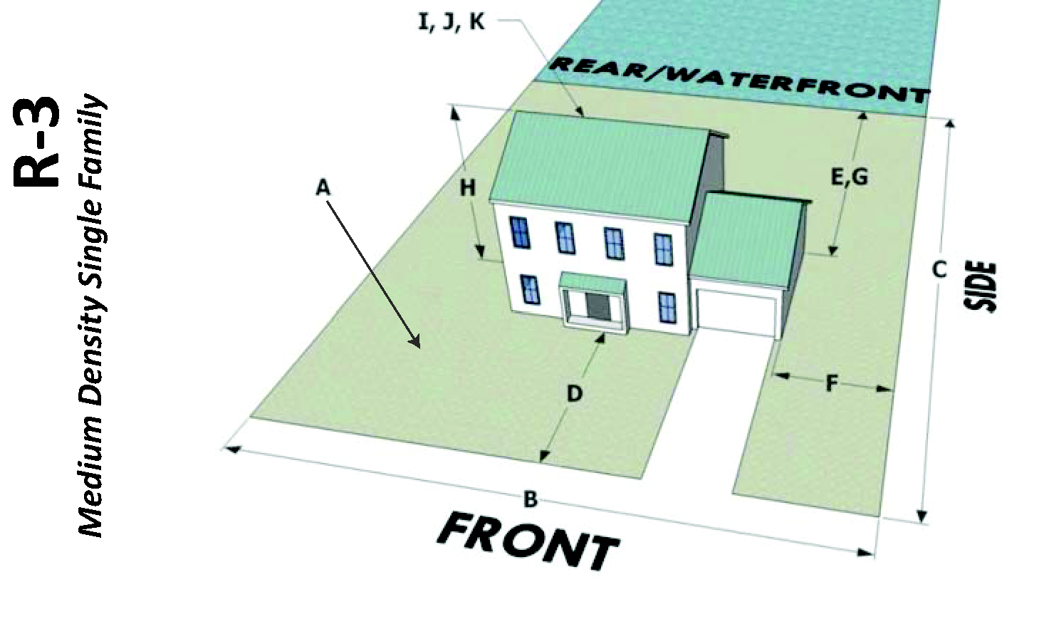
D.
Development permit review. A development permit application shall be submitted and reviewed pursuant to section 6.5.
(Ord. No. 2013-02, § 4, 3-21-2013; Ord. No. 2013-08, § 2(Exh. A), 6-20-2013)
SECTION 2.8. - MF-1 (MEDIUM-HIGH DENSITY MULTI-FAMILY)
A.
Purpose and intent. The medium-high density multi-family residential zoning district is intended to provide relatively low-density multi-family development which emphasizes open space and maintains a low profile, thus being suitable as a transitional use between single-family and higher-density multi-family residential developments.
B.
Permitted uses and structures. See section 2.40, Table 2-5 (Table of Permitted Uses).
C.
Dimensional requirements.
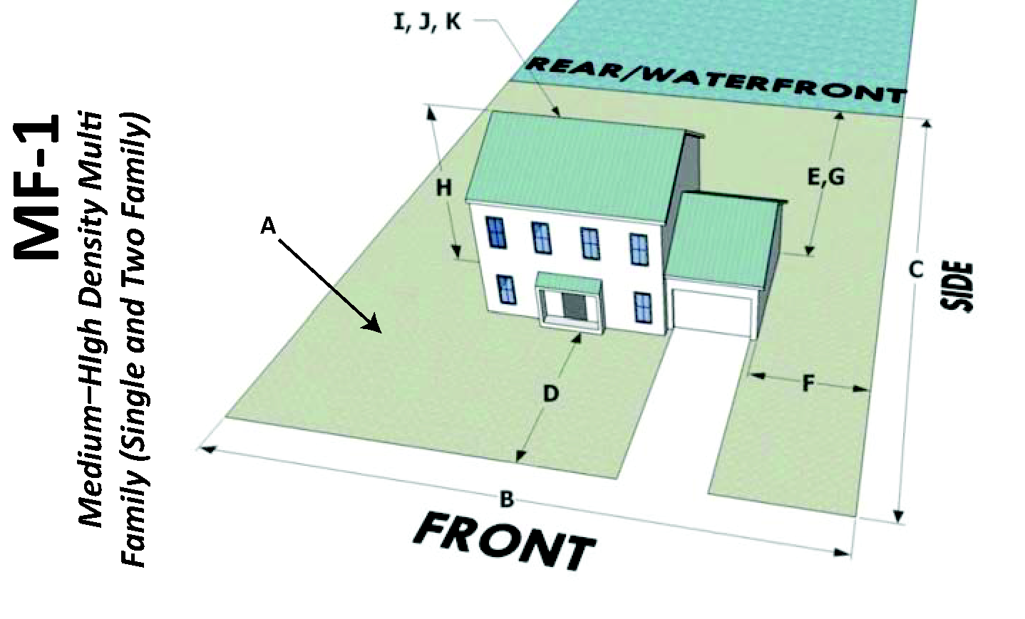
D.
Development permit review. A development permit application shall be submitted and reviewed pursuant to section 6.5.
(Ord. No. 2013-02, § 5, 3-21-2013; Ord. No. 2013-08, § 2(Exh. A), 6-20-2013)
SECTION 2.9. - MF-2 (HIGH DENSITY MULTI-FAMILY)
A.
Purpose and intent. The high density multi-family residential zoning district is intended to provide relatively high-density multi-family development in areas principally along the ocean front or riverfront where high-density development exists or is proposed.
B.
Permitted uses and structures. See section 2.40, Table 2-5 (Table of Permitted Uses).
C.
Dimensional requirements.
D.
Development permit review. A development permit application shall be submitted and reviewed pursuant to section 6.5.
E.
Riverfront overlay standards apply. The riverfront overlay district regulations (section 2.14) apply to all new development or redevelopment activities in the MF-2 zoning district within the area described in subsection 2.14.A.
(Ord. No. 2013-02, § 6, 3-21-2013; Ord. No. 2013-08, § 2(Exh. A), 6-20-2013)
SECTION 2.10. - B-1 (GENERAL RETAIL)
A.
Purpose and intent. The general retail commercial zoning district is intended to provide areas for a broad range of retail commercial and business establishments which meet the frequent needs of Ponce Inlet residents.
B.
Permitted uses and structures. See section 2.40, Table 2-5 (Table of Permitted Uses).
C.
Dimensional requirements.

D.
Development permit review. A development permit application shall be submitted and reviewed pursuant to Section 6.5.
SECTION 2.11. - B-2 (RIVERFRONT COMMERCIAL)
A.
Purpose and intent. The purpose of this riverfront commercial zoning district is to create an area that is characterized by small-scale retail outlets and to retain and enhance those elements of the water-oriented commercial activity that can be integrated into a small town fishing village concept. The intent is to promote development that will be of a scale that promotes social interaction. However, projects of this type will have to be especially sensitive to the environment in which they are proposed to be built, so that the desired character and charm have an opportunity to be developed.
B.
Permitted uses and structures.
1.
See section 2.40, Table 2-5 (Table of Permitted Uses). No premises shall be used except as listed in Table 2-5, including their customary accessory uses or structures. In addition, one dwelling unit per business is allowed for employee or business owner housing, not to exceed 2.9 dwelling units per acre.
2.
Water-dependent uses and water-enhanced uses from section 2.40, Table 2-5 (Table of Permitted Uses) are permitted along the shoreline. All other uses shall be located primarily upland from the shoreline.
3.
Development of property in this district shall be guided by the town's shoreline priority policy, namely that, along the shoreline, only the following uses should occur:
a.
Water-dependent and water-related uses that are targeted to protect environmental resources; promote public access; and/or encourage, revitalize and retain traditional waterfront economies; and
b.
Family-oriented restaurants.
4.
Uses that do not directly benefit from the waterfront, but that are permitted by this section, shall be located upland from the shoreline. Riverfront commercial projects that integrate a mix of permitted principal and accessory uses (such as garages in association with principal permitted uses only), boat slips, maintenance structures, etc., shall adhere to a common architectural theme.
C.
Dimensional requirements.
D.
Development and design standards.
1.
Off-street parking and loading requirements. Off-street parking and loading shall meet the requirements of section 4.7.
2.
Dry boat storage. Dry boat storage in the B-2 zone district shall comply with section 3.10.3.
3.
Landscape buffer requirements. A landscaped buffer area meeting section 4.10.3 shall be constructed.
E.
Development plan permit review. A development plan permit application shall be submitted and reviewed pursuant to section 6.5.
F.
Riverfront overlay standards apply. The riverfront overlay district regulations (section 2.14) apply to all new development or redevelopment activities within the area described within subsection 2.14.A.
(Ord. No. 2015-06, § 2(Exh. A), 10-15-2015; Ord. No. 2020-02, § 2, 5-21-2020)
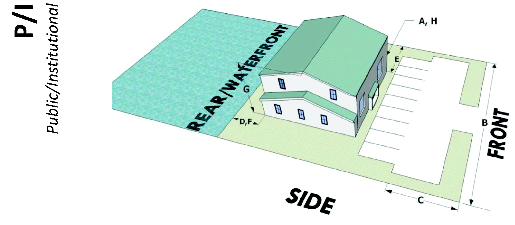
SECTION 2.12. - P/I (PUBLIC/INSTITUTIONAL)
A.
Purpose and intent. The purpose of this district is to permit any lawful governmental activity of federal, state and local governments as well as quasi-public and private activities or facilities which will serve the public interest in an educational, recreational, or scientific context.
B.
Permitted uses and structures. See section 2.40, Table 2-5 (Table of Permitted Uses).
C.
Dimensional requirements.
D.
Development permit review. A development permit application shall be submitted and reviewed pursuant to section 6.5.
SECTION 2.13. - PUD (PLANNED UNIT DEVELOPMENT)
A.
Purpose and intent. The purpose of this district is to permit large-scale, comprehensively planned residential developments containing a variety of housing types and densities with common open space areas, community facilities, and limited commercial facilities serving the needs of the residents of the district. Any approval under this section shall be in compliance with F.S., §§ 163.3220—163.3215, the Florida Local Government Development Agreement Act.
B.
Permitted uses and structures. See section 2.40, Table 2-5 (Table of Permitted Uses). Permitted principal uses and structures on privately owned lands shall be listed in the development agreement. No commercial structure or any building devoted to commercial use shall be built or established prior to the residential buildings it is designed and intended to serve.
C.
Dimensional requirements.
 | ||||
| Minimum Parcel Size | Minimum Lot Area and Yard Requirements | Density | Perimeter Setbacks | Maximum Height |
| 80 acres |
As described in development agreement. The following also applies:
• Single-family: 25 percent of the PUD area shall be single-family use meeting or exceeding the minimum standards of the R-2 zoning district. | May not exceed the density permitted by the underlying future land use category. |
Off-street parking and loading areas and driveways: 40 feet from the perimeter boundary
of any PUD project.
Buildings: 40 feet from the perimeter boundary of a PUD project, except that a setback of 200 feet is required for commercial buildings. [1] | 35 feet |
| • Multifamily: Minimum lot area and yard requirements for multi-family uses shall meet or exceed the minimum standards of the MF-1 zoning district. | ||||
| [1] The town council may impose more stringent perimeter setback requirements when considered necessary to protect and preserve adjacent land uses. For the purposes of this section, the project perimeter boundary adjacent to the Atlantic Ocean shall be the town bulkhead line; the project perimeter adjacent to wetlands shall be the boundary of wetland vegetation as defined in Chapter 17-3.022, Florida Administrative Code. The perimeter boundary setback shall always include a 25-foot landscaped buffer. | ||||
D.
Development and design standards.
1.
Landscaped buffers. A 25-foot natural undisturbed buffer shall be preserved along the project boundary perimeter and along wetland boundaries of the project to screen the project from the adjacent areas. Where the existing vegetation in the natural undisturbed buffer has been disturbed or does not provide a screen in accordance with the shade tree and understory tree spacing defined below, shade trees and understory trees shall be added in accordance with the size and type as listed below. The existing vegetation along a perimeter boundary adjacent to the Atlantic Ocean and Halifax River may satisfy this requirement.
a.
Spacing.
(1)
Shade trees: Four per 100 lineal feet.
(2)
Understory trees: Six per 100 lineal feet.
b.
Plant material. All plant material shall be Florida No. 1 grade or better, according to the current "Grades and Standards for Nursery Plants", State of Florida, Department of Agriculture, and shall contain the following minimum specifications:
(1)
Trees, general: Shade trees species indigenous to the area shall have an average mature spread of crown greater than 15 feet at maturity, be self-supporting woody plants and be a minimum of two-inch caliper, ten feet high at the time of planting.
(2)
Ornamental and understory tree species: Myrtles, dogwoods, hollies, and/or species indigenous to the area shall be a minimum of one-inch caliper, four feet high at the time of planting.
(3)
Permitted plant materials: Plant species must be selected from the town plant list which is maintained and periodically amended as necessary. The town plant list is available in the town hall. The use of salt-tolerant plants identified on the town plant list is encouraged. Synthetic, common noxious, non-native invasive, and hazardous plant materials are prohibited.
c.
Installation and maintenance of landscaping.
(1)
Landscape plan: A landscape plan that is labeled, signed, and sealed by a licensed landscape architect in the State of Florida shall be submitted as one of the exhibits required in the subdivision approval or site plan approval process. The plan shall indicate the type, size, and location of all existing and proposed plant and landscape materials. No building permit shall be issued until the landscape plan is approved.
(2)
Installation and improvements: All landscape materials shall be installed according to professionally accepted planting procedures. Trees two inches and over in caliper shall be guyed and staked. No certificate of occupancy shall be issued for any structure on a property until the improvements shown on the approved landscape plan are installed and the entire project boundary perimeter buffer is in place.
(3)
Maintenance: Where landscaped areas are required, the developer shall be responsible for the maintenance and replacement of the plant materials for a period of one year from the completion of that phase of landscaping. The developer shall submit status reports to the director at the end of six months and at the end of one year after installation. The reports shall detail the health status of the installed landscape materials and be prepared, labeled, signed, and sealed by a Florida licensed landscape architect. The developer shall be required to post a maintenance bond, a certified check or cash deposited in an escrow account in the amount of ten percent of the contract amount, to be verified by the director and finance manager.
(4)
Maintenance of landscaped buffers: Maintenance of landscaped buffers shall be the responsibility of the homeowner's association. Landscaped areas shall be maintained in a healthy and orderly condition and kept free from refuse or debris. If any living material that is specifically required by these regulations dies or fails to achieve normal growth, it shall be replaced within 30 days of notification from the town, with similar type material meeting the minimum specifications of this agreement. All landscaped areas shall be protected from traffic encroachment by the use of wheel stops, continuous curbing or other methods approved by the town. Landscaped buffers shall be easements that are dedicated to the town. These easements shall contain the provision that, if the easement areas are not maintained in accordance with these regulations the town council may provide the proper maintenance and place a lien on the common facilities of the PUD for the cost thereof.
2.
Off-street parking and loading. Off-street parking and loading space meeting section 4.7.
3.
Private streets. Private streets may be permitted by the town council if right-of-way and pavement are in accordance with town subdivision standards and specifications. Private streets are not allowed along the project perimeter. The town shall have access by easement for public safety and welfare to any portion of a private street that contains water or other utility lines under public control.
4.
Unified ownership. All land within the PUD shall be under unified ownership, whether by deed, agreement for deed, or contract for purchase at the time of rezoning. PUD applicants shall present either an opinion of title by an attorney licensed in Florida or a certification by an abstracter or a title company, authorized to do business in Florida, that at the time of application, unified ownership of the entire area with the proposed PUD is in the applicant or contract seller. Unified ownership shall be maintained until after the recording of the overall development plan or final plat. The provisions of the PUD shall be binding on successors of ownership.
5.
Open space requirements. Sixty percent of the project area shall be open space. Open space is that area at ground level primarily devoted to planting, patios, guest parking areas, walkways, grass, etc., but excluding areas covered by dwelling units, garages, driveways or common parking areas, or paved portions of streets. Up to 15 percent of the open space may be wetlands. A minimum of 35 percent of the open space shall be designated as common open space to be used for recreational, park, environmental, or amenity, including additional guest parking areas, for collective enjoyment by the residents of the PUD. Common open space shall meet the following standards:
a.
It shall be dedicated to and usable by all residents of the PUD;
b.
Its location, shape, size and character shall be illustrated on the overall development plan.
c.
Common open space must be suitably improved for its intended use. Common open space containing natural features deemed worthy of preservation by the planning commission or town council shall be left unimproved.
d.
Maintenance guarantees shall be approved by the town council upon recommendation of the town attorney.
e.
Common open space shall not include any buildings other than those used for recreational purposes.
f.
Water retention may not be included as common open space.
6.
Homeowners' association. Appropriate legal provisions concerning the establishment of the homeowners' association and declaration of restrictions shall be included in the resolution and approved by the town attorney. The homeowners' association's legal provisions shall include the following requirements:
a.
The association shall be established before the dwellings are sold.
b.
Membership shall be mandatory for each buyer and successive buyer.
c.
The association shall be responsible for the liability insurance, local taxes and the maintenance of recreational and other facilities and landscaped buffers.
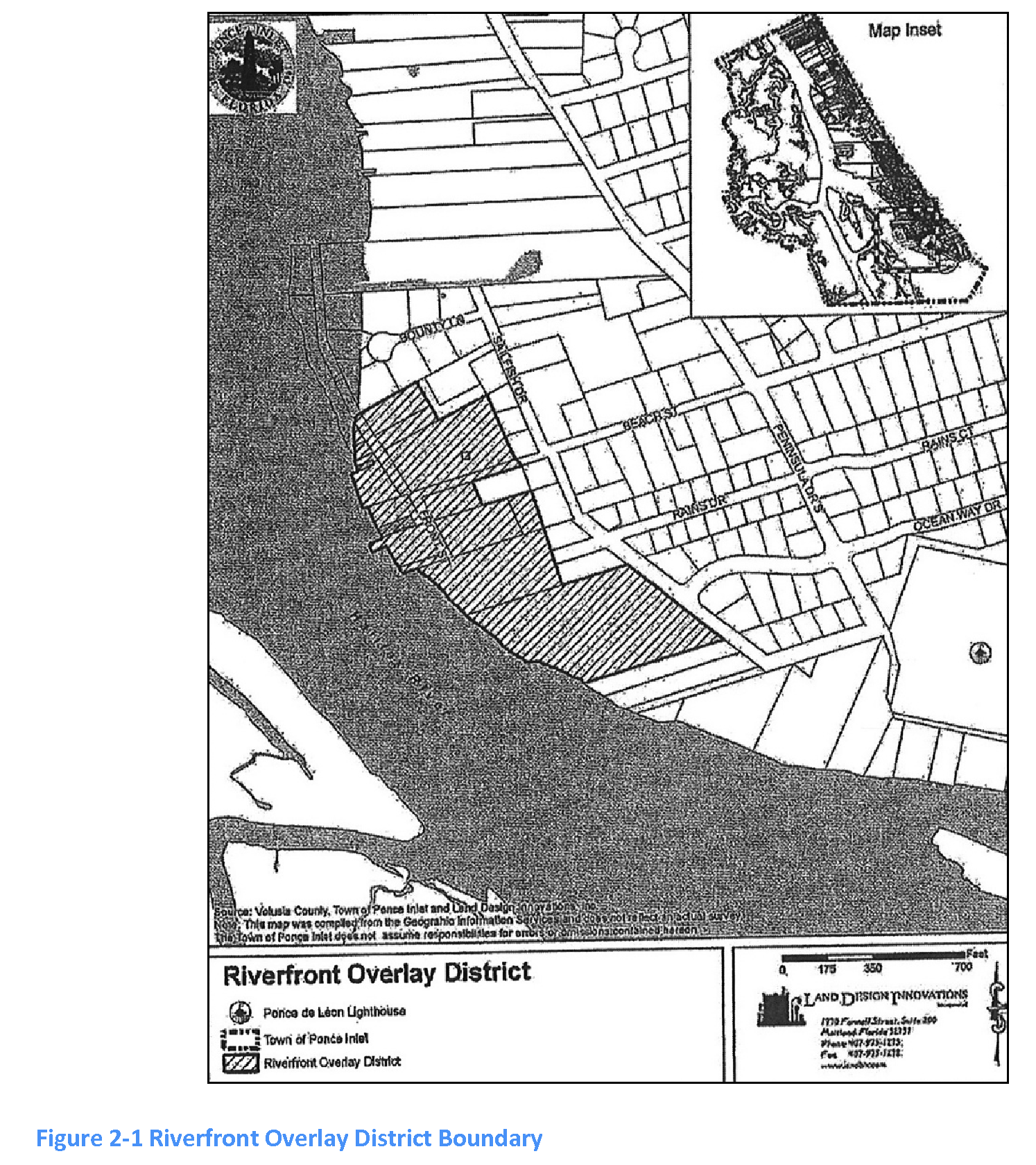
SECTION 2.14. - ROD (RIVERFRONT OVERLAY)
A.
Purpose and intent. The riverfront overlay district (ROD) is intended to provide supplementary regulations to all of the B-2 and MF-2 zoning districts lying east of the Halifax River and west of Sailfish Drive to assure that development within this area promotes the open, water-oriented character of the riverfront, protects environmental resources and ensures a high quality of design. (See Figure 2-1, riverfront overlay district boundary, that graphically depicts the extent of the ROD.) Additionally, the ROD is consistent with the town's comprehensive plan goals, objectives and policies that have been established as a result of the town's visioning process regarding development and redevelopment of Ponce Inlet's riverfront. These goals, objectives and policies were established to not only create a pedestrian-oriented riverfront environment in a manner that contributes to making Ponce Inlet a better residential community, but also to ensure access to the riverfront for both pedestrians and bicyclists and preserve the historic setting and unique character of this area, including, but not limited to, the scenic roads of Beach Street and Sailfish Drive designated by town Resolutions 1999-11 and 2000-09.
B.
Permitted uses and structures. The permitted uses shall be those allowed by the underlying B-2 or MF-2 zoning districts, respectively, subject to the regulations and restrictions of these underlying zones, in addition to this ROD.
C.
Development regulations. Within the ROD no building, improvement or portion thereof shall be erected, constructed, converted, altered or enlarged or demolished until a riverfront development permit (RDP) is obtained in accordance with the procedures set forth in this section. Maintenance activities, such as repainting, reroofing, repaving and structural repairs shall not require a RDP. However, the applicant shall obtain all other applicable permits (i.e., building, electrical, etc.) required by the town and any other applicable permits from governments agencies.
D.
Riverfront development permit.
1.
To develop or redevelop property within the ROD, an application for a RDP shall be filed with the planning and development department. The application shall be accompanied by site plans, tree surveys, landscape plans (including all information pertaining to lighting and signs as required by subsections 2.14.E.5 and 2.14.E.8 below), plan sections, elevation drawings (including facade treatment), colored renderings, and appropriate fees as adopted by resolution of the town council. The director shall examine the application package for completeness and, once the package has been found to be complete, shall schedule it for review by the staff development review team. The materials submitted with a RDP request shall be limited to those necessary for the development review team to determine whether the criteria listed in subsection 2.14.D.4 below would be met.
2.
The development review team shall examine all submitted documents, and determine whether or not a RDP should be issued. The development review team shall not approve the RDP application unless the available information supports the findings of fact set forth in subsection 2.14.D.4 below. In approving an RDP application, the development review team may impose such conditions as deemed necessary and desirable to protect the public health, safety and general welfare with respect to the findings of facts listed in subsection 2.14.D.4.
3.
Any decision of the development review team regarding a RDP may be appealed to the planning board upon submittal of the appropriate application within ten days of said decision.
4.
In reviewing an application for a RDP, the development review team shall make the following findings of fact to determine if the proposed development should be approved:
a.
The proposed development is consistent with the purpose and intent of the ROD.
b.
The proposed development is consistent with the Ponce Inlet Comprehensive Plan.
c.
The proposed development meets the concurrency management requirements of the town's LUDC. Traffic impacts upon the scenic roads of Beach Street and Sailfish Drive will be minimized to the maximum extent possible by the use of interior drives, lanes or other means. The Institute of Traffic Engineers Handbook (latest edition) shall be used to determine the number of trips projected to be generated by the proposed development.
d.
The site is physically suitable for the project design as determined by the regulations contained in the LUDC. In particular, attention must be given to LUDC sections 4.8 (Resource Protection), and 4.10 (Tree and Native Vegetation Preservation, Buffers and Landscape Requirements), and Code of Ordinances, chapter 18, article X (Flood Damage Prevention).
e.
The proposed development will not adversely impact wetlands, and/or plants and animals that are listed as federal and/or state endangered, threatened, or species of special concern.
f.
The architectural style and building scale of any proposed development reflects the historic setting and the unique character of the ROD area.
g.
The site and landscape design of any proposed development within the ROD is consistent and coordinated with the historic setting and the unique character of the environment of the ROD area and does not adversely impact development within and adjacent to the ROD. In particular, attention must be given to section 4.10 (Tree and Native Vegetation Preservation, Buffers and Landscape Requirements.
h.
The proposed development retains or enhances the visual quality of the site. In particular, attention must be given to section 4.10.
i.
The open space within the proposed development is coordinated with existing and planned interconnected open space systems.
j.
The proposed development is designed to relate to other existing and (if known) planned projects and systems, such as pedestrian ways, open space areas, landscaping patterns, lighting concepts, and traffic circulation.
k.
The proposed development is designed to provide physical access to the riverfront and other activities as listed in subsection 2.14.F.2 below.
l.
Buildings and structures abutting or adjacent to Front Street (or any extension to said street) are designed in such a manner as to allow views of the riverfront from Front Street and from adjacent developments or properties.
m.
The proposed development preserves the existing tree canopy in this district, which creates the special ambience of this area and controls the density of development, and does not exceed 35 feet in height. However, if the proposed 35-foot building height would result in the removal of any portion of a specimen or historic tree canopy to accommodate it, then a certified arborist shall be retained by the developer to indicate the minimum amount of vegetation that may be removed to accommodate the building height while preserving the health of the tree, as well as its canopy. This requirement shall not apply to those specimen and historic trees that comply with the provisions of section 4.10 of this code.
n.
The treatment of the river edge shall be visually appealing when viewed from the river and the land.
E.
ROD design standards. The following design standards shall apply to all development within the ROD:
1.
Landscaping and grading.
a.
Designated parking areas shall be landscaped or fenced with appropriate material to at least partially screen said areas from view from access streets, adjacent properties and the riverfront. Berms (in combination with plantings or low walls) to screen parking areas are appropriate design solutions.
b.
Where landscape materials are proposed for screening purposes, the seasonal density and buffering capabilities of the selected vegetation shall provide a fully opaque screen within two years from the time of planting.
c.
Developments fronting upon or adjacent to scenic roads (i.e., Sailfish Drive), shall be required to observe the protected area restrictions of 15 feet extending from the right-of-way as established by the town's scenic roads requirements. In addition, such restrictions must be observed for an additional 20 feet west of Sailfish Drive's right-of-way (for a total of 35 feet) in order to maintain the existing tree canopy and other non-invasive natural vegetation.
2.
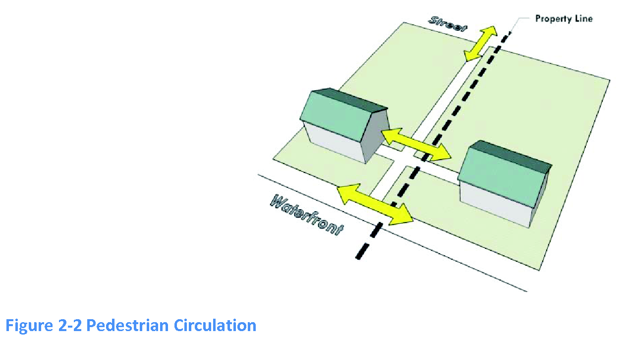
Circulation (pedestrian and vehicular).
a.
Pedestrian walkway systems and street crossings that encourage trips on foot or bicycle, particularly from residential neighborhoods to the ROD area, shall be incorporated into the project design.
b.
The quality of the sidewalk environment within the ROD shall be enhanced by means of appropriate landscaping, lighting, graphics, street furniture, and overall design. Additionally, sidewalks shall be paved in compliance with the town's sidewalk paving standards or finished with brick or sett stone pavers.
c.
The internal pedestrian circulation system within any proposed development in the ROD area shall be consistent with the town's Sidewalk and Bikepath Network Master Plan.
d.
Parking lots, loading and unloading zones, storage areas, and similar uses shall be located away from the riverfront and away from the scenic roads of Beach Street and Sailfish Drive. Such uses shall be placed in unobtrusive areas and buffered from any adjoining residential property as required by this LUDC. In areas characterized by buildings located along the street line, parking, service and outside storage areas shall be located behind the buildings whenever possible.
e.
Designated pedestrian access ways between Front Street and the river's edge shall be encouraged.
f.
Sailfish Drive, designated as a scenic road by the town, is a sand-base road, uniquely fragile and limited in its ability to carry any significant amount of traffic for most of its length. Any application for a RDP shall positively address the means by which construction and post-construction traffic will avoid adversely affecting the character and quality of this scenic road. The application shall also provide for permanent features to channel motor vehicle traffic movements within or around the proposed development to points where such traffic may enter or leave the development without adversely impacting Sailfish Drive.
3.
Building design, materials and color.
a.
The use of unfinished common concrete block, cinder block, corrugated panels, or simulated materials such as vinyl and aluminum siding as the primary facing material for exterior building walls in the ROD is prohibited.
b.
All construction shall be of high-quality finish materials that are in harmony with the historic and unique character of the ROD area.
c.
The predominant exterior colors shall be complementary and harmonious to the character of the riverfront environment and surrounding development.
d.
Bright colors shall not dominate but may be permitted by the planning board as compatible accents.
e.
Large areas of blank walls are to be avoided. Special treatment with screening, landscaping and the like is desired where such conditions are unavoidable. Additionally, windows (real or false) shall be installed on all walls that are visible from public areas.
f.
When the street level of a structure is to be used for storage, parking or is a vacant area, appropriate treatment with masonry, finish material, screening, or landscaping shall be provided.
g.
Mechanical or utility equipment located on the exterior and the roof of a building shall be appropriately screened from public view or designed as an integral part of the overall exterior appearance.
h.
Service areas, loading docks and refuse collection and storage areas shall be located away from or screened from public view.
4.
Preservation of historic sites and structures.
a.
Projects that propose to enhance buildings or sites eligible for inclusion on the National Register of Historic Places shall be encouraged.
b.
All buildings are recognized as products of their own time. Alterations, additions and new development shall be harmonious with and similar to the historic character of the ROD area, and not simply mimic an earlier or different architectural style.
c.
The distinguishing original qualities of any existing building in the ROD shall not be diminished by alteration or the removal of distinctive architectural features. When replacing original elements, new materials shall match as closely as possible with the composition, design, color, texture, and other visual qualities.
5.
Lighting. Lighting shall comply with all applicable provisions of section 3.30 (Signs) of the LUDC and the following requirements.
a.
Lighting fixtures and standards in publicly accessible areas shall acknowledge the unique character of the ROD.
b.
Exterior lighting shall enhance the site and building design.
c.
Specialized lighting may be permitted with approval of the planning board to accent architectural or landscape features.
d.
Lighting shall be restrained to prevent excessive brightness and undue glare on the Halifax River.
e.
Lighting levels and color shall be designed to consider the overall effect on patterns, repetition, focal points, and rhythm within the panorama of the riverfront.
f.
Building illumination and architectural lighting shall be indirect and with no visible light source.
g.
Ground-level light fixtures shall be of the burial vault type or fully screened by landscaping material.
h.
Illumination from any light source onto adjacent properties shall not exceed 0.5 foot-candle.
i.
Lighting of parking areas, access drives and vehicular circulation areas shall consist of full cut-off shield type fixtures mounted at the top of a pole. Poles and fixtures shall not exceed 20 feet in height, including the base, and shall be anodized bronze or black in color consistently throughout the pole.
j.
Light poles shall be located only in landscape strips, buffers or planting islands.
k.
The minimum setback of the light pole from the property line shall be a horizontal distance of 20 feet.
6.
Utilities.
a.
All utility services (telephone, electrical, cable, and the like) shall be installed underground.
b.
All utility components required to be above-ground (transformers, and the like) shall be screened by landscaping or a decorative wall. Wall-mounted meters and similar equipment may be painted to match the wall on which they are mounted in lieu of screening, if placed unobtrusively and not in full view of the public right-of-way.
7.
Retaining walls, fencing and railings.
a.
Retaining walls shall be faced with finished masonry or other decorative screening or landscaping to minimize the blank appearance of such walls.
b.
Fence and rail designs shall be compatible with the historic character of the surrounding neighborhood.
c.
Proposed fencing shall not limit actual or visual access to the riverfront, except where necessary for safety, security or to protect an environmentally sensitive area.
d.
Chain-link fencing is considered to be inappropriate in the ROD and shall not be permitted in any location that may be visible from public areas.
8.
Signage. Signage shall comply with the applicable provisions of section 3.30 (Signs) of the LUDC and the following requirements.
a.
Signs shall be designed to enhance the visual appeal of the ROD and relate to the need to provide information to the public. The size, height, number, style, shape, material, design, graphics, illumination, and color of signs shall be reviewed and approved by the planning board with regard to their ability to meet the purpose and intent of the ROD without compromising traffic safety.
b.
In general, attached signs shall be designed to fit within the architectural space intended for signage, and not cover any architectural features.
c.
Signs that are viewed in relation to other signs shall be designed to be compatible with regard to location, shape, style, graphics, size, material, illumination, and color.
F.
ROD open space area requirements. The following requirements shall apply to all required open space areas within the ROD:
1.
A minimum of 30 percent of a development's land area shall be devoted to open space. The application shall clearly indicate all areas proposed to be devoted to open space on the site plan.
2.
A minimum of 15 percent of the required open space area (4.5 percent of the total project area) shall be designed as active open space and contain one or more activities that are intended for such purposes as sitting, talking, meeting, eating, meditating, viewing, reading, relaxing, and any other forms of activity commonly associated with and/or fostering human interaction. In those cases where these activities cannot be accommodated, as determined by the planning board during the site plan review and approval process, the open space shall be landscaped. At least 40 percent of the 15 percent active open space area (1.8 percent of the total project area) shall be shaded by trees or a combination of trees and unenclosed shading structures.
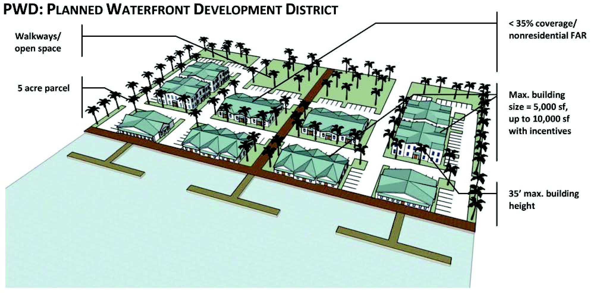
SECTION 2.15. - PWD (PLANNED WATERFRONT DEVELOPMENT)
A.
Purpose and intent. The purpose of the planned waterfront development district is to:
1.
Protect and preserve the town's waterfront with a compatible, complimentary mix of water-dependent and water-related uses that maintain its status as a vibrant working waterfront;
2.
Ensure adequate public pedestrian access to the waterfront;
3.
Ensure a high quality of site planning and architectural design in waterfront areas;
4.
Enhance and preserve environmentally sensitive areas along the waterfront;
5.
Maximize opportunities for public views of the water;
6.
Allow for flexible and creative design approaches to development and redevelopment that achieve the goals of this section;
7.
Encourage a master planning approach on large sites to ensure orderly and compatible development patterns;
8.
Provide incentives for development to include community amenities that exceed the LUDC and further achieve the stated purposes of the planned waterfront development district;
9.
Provide a district that is an attractive and viable mixed use district; and
10.
Implement policies related to the planned waterfront development district set forth in the comprehensive plan.
B.
Applicability.
1.
The standards in this section apply to all development and redevelopment in any planned waterfront development district (PWD) as described in a development agreement approved pursuant to subsection 2.15.I below. In order to be eligible for a zoning change to the planned waterfront development district, the property must comply with the zoning/future land use plan compatibility matrix set forth in the comprehensive plan.
2.
Portions of any PWD that are within an ROD district are subject to the riverfront overlay district (ROD) regulations in addition to these regulations. If there is a conflict between an ROD regulations and this section, the ROD regulations control.
C.
Permitted uses and structures. See section 2.40, Table 2-5 (Table of Permitted Uses). The following also applies:
1.
Required mix of uses in the planned waterfront development district. Development in the planned waterfront development district shall comply with the following required mix of use standards. The required development agreement in section 2.15.I below must indicate the percentage of lot area that is allocated to each use. Bonuses for building floor area and residential density for mixed use are set forth in subsection 2.15.H below.
2.
Mix of uses by lot area. All development in any PWD district shall comply with the following standards for mix of use by lot area. For purposes of subsection 2.15.C.1 above, the "mix of use" refers to the percent of uses on the site for each category of use (see Table 2-1 below).
Table 2-1, Required Mix of Use by Lot Area
Reference: Policy 1.2.2(g)(4) of the Future Land Use Element of the comprehensive plan.
3.
Calculation of use mix. The following standards apply to the calculation of lot area in any PWD district for the purpose of calculating the required mix of uses.
a.
"Net lot area" refers to those upland land areas utilized for each use, excluding roadways, public and private streets, and dedicated utility easements. All portions of the net lot area are allocated to the use categories listed in Table 2-1.
b.
The Use Mix in Table 2-1 is determined as follows:
D.
Dimensional requirements. Dimensional standards for any PWD zoning district are set forth below.
 | |||||
|
(A)
Minimum District Size |
(B)
Minimum Yard Size [2] |
(C)
Max. Building Height |
(D)
Max. Lot Coverage |
(E)
Max. Building Size |
(F)
Base Max. Non-Residential Floor Area Ratio (FAR)/ Residential Density |
| 5 acres [1] | 10' or as determined in the development agreement | 35' | 35% | 5,000 square feet of floor area [3] for any building |
FAR .35;
Density = 2.9 units/acre [4] |
[1] For the purposes of this section, the five-acre minimum lot area shall include properties of five contiguous upland acres or larger that create unity of title. More than one principal use or structure is permitted on this lot.
[2] Yard sizes apply only to the exterior of the district area, and as otherwise defined for individual buildings in the development agreement. Any side or rear yard abutting residentially zoned property shall have a setback of 35 feet. Any lawful principal and/or accessory structure in existence as January 7, 2004, that could not be rebuilt to its original footprint because of the ten-foot minimum waterfront yard setback requirement is not subject to section 7.5 of the LUDC, and may be rebuilt to replicate its original footprint. However, any enlargement, expansion, alteration, or movement in excess of the original footprint shall comply with the ten-foot minimum waterfront yard setback requirement.
[3] Increases to this maximum building size requirement may be allowed in accordance with subsection 2.15.I (Development agreements) below.
[4] Increases to this maximum residential density and non-residential floor area ratio may be allowed through a development agreement in accordance with subsection 2.15.H below.
E.
Development and design standards. The following development and design standards apply to all development in any PWD zoning district.
1.
Residential dwelling units.
a.
More than one dwelling unit is allowed per lot, consistent with the density standards for the entire district area.
b.
Residential uses may include single-family, two-family, and multi-family dwelling units.
c.
Existing density rights may be transferred anywhere within the unified ownership of the development and any density bonus allowances in subsection 2.15.H.
d.
The minimum floor area for each dwelling unit shall be 1,400 square feet.
2.
Drive-through prohibited. Drive-through facilities are not permitted in any PWD zoning district.
3.
Pedestrian access and circulation. Development in any PWD zoning district shall comply with the following access and circulation standards in addition to complying with the town's sidewalk and bikepath network master plan.
a.
External connectivity.
(1)
Site planning shall include pedestrian access connecting to off-site public roads, walkways, and bike paths.
(2)
For sites adjacent to residentially zoned property, pedestrian access shall be incorporated to these areas to the extent practicable.
b.
Internal connectivity. Sidewalks and pedestrian access ways shall be constructed within the interior of the development to link buildings with other destinations, such as, but not limited to, parking, adjoining streets, mailboxes, trash disposal, adjoining sidewalks, waterfront areas, and on-site amenities such as recreation areas. Sidewalks shall be paved in compliance with the town's sidewalk paving standards or finished with brick or sett stone pavers.
c.
Connections to waterfront. Additional standards for connectivity to waterfront areas are set forth in subsection 2.15.E.7, below.
4.
Open space. A PWD that is outside of the riverfront overlay district (ROD) must provide open space as follows:
a.
A minimum of 30 percent of a development's land area shall be devoted to open space. The application shall clearly indicate all areas proposed to be devoted to open space on the site plan.
b.
A minimum of 15 percent of the required open space area (4.5 percent of the total project area) shall be designed as active open space and contain one or more activities that are intended for such purposes as sitting, talking, meeting, eating, meditating, viewing, reading, relaxing, and any other forms of activity commonly associated with and/or fostering human interaction. In those cases where these activites cannot be accommodated, as determined by the planning board during the site plan review and approval process, the open space shall be landscaped. At least 40 percent of the 15 percent active open space area (1.8 percent of the total project area) shall be shaded by trees or a combination of trees and unenclosed shading structures.
5.
Building design and materials. The following building design and materials standards apply to all development in the PWD zoning districts, except as modified in an approved development agreement.
Table 2-2, Design Standards
| Category | Standards | |
|---|---|---|
Architecture | Four-Sided Architecture Required | |
| A building's architectural features and treatment shall be applied to all sides of buildings. Building details, including roof forms, windows, doors, trim, and siding materials, shall reflect the architectural style of the building. All sides of a commercial building shall display a similar level of quality and architectural detailing. |  | |
| Blank Walls Prohibited Any wall that faces a street, connecting pedestrian walkway, or residential use, and that exceeds 30 feet in length shall include a minimum of two of the following within each successive 30-foot section or fraction thereof. Change in wall plane, such as projections or recesses, having a depth of at least three percent of the length of the facade and extending at least ten percent of the length of the facade. • Change in texture or pattern; | 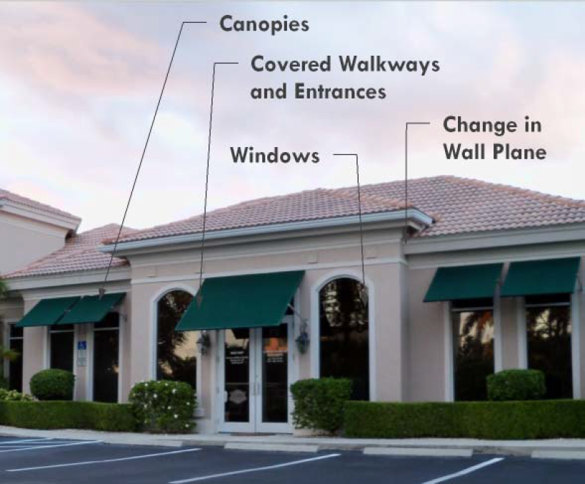 | |
| • Windows; | ||
| • Covered walkways or entrances; | ||
| • Canopies; or | ||
| • An equivalent element that subdivides the wall into human-scale proportions. | ||
Building Materials and Colors | Allowed Primary Exterior Building Materials All primary exterior building materials shall be durable, economically maintained, and of a high quality that will retain its appearance over time. The following materials are allowed as primary exterior building materials: • Brick and materials identical in appearance |  |
| • Sandstone or natural or synthetic stone | ||
| • Tinted and textured concrete masonry units | ||
| • Wood and composite materials identical in appearance. Wood may include horizontal boards and board-and-batten | ||
| • Cast stone | ||
| • Stucco | ||
| • Architectural metals or other materials as provided in the development agreement | ||
| Prohibited Primary Building Exterior Materials | ||
| • Smooth-faced concrete block | ||
| • Smooth-faced tilt-up concrete panels | ||
| • Prefabricated metal panels, galvanized tin, or other metal except as provided above | ||
| • Vinyl | ||
| • EIFS | ||
Roofing |
Roofing materials and roofing styles include, but are not limited to:
Allowed Roofing Materials • Wood (or material appearing identical to wood) | 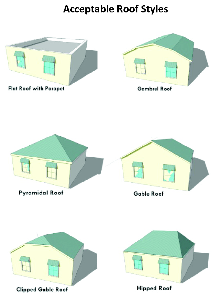 |
| • Metal roofs consisting of either: a) standing seam metal, b) V-crimp roofing appearing similar to standing seam metal, or c) metal paneled roofs consistent with existing area development | ||
| • Fiberglass shingles, architectural grade asphalt shingles | ||
| • Slate or clay tile including barrel tiles | ||
| • For flat roofs: rubber membrane, asphalt, gravel, or other materials that are customarily used for flat roofs | ||
| • Green roof, defined as an engineered roofing system that allows for the propagation of rooftop vegetation while maintaining the integrity of the underlying roof structure and membrane. | ||
|
• Other acceptable materials as approved in a development agreement
Allowed Roof Styles | ||
| • Flat roofs with parapets | ||
| • Gambrel roofs | ||
| • Pyramidal roofs | ||
| • Gable roofs (including clipped gable) | ||
| • Hipped, and half-hip roofs | ||
| • Other acceptable styles as approved in a development agreement |
6.
Parking and loading. Off-street parking and loading requirements meeting section 4.7 shall be provided.
7.
Landscaping and screening of parking and loading areas. In addition to the standards in section 4.7, the following standards apply to parking areas in the PWD districts.
a.
Adjacent to residential. Whenever a parking lot or loading area boundary adjoins property with the zoning below, a landscape buffer of a minimum six feet from the lot boundary is required. The landscape buffer shall include a six-foot-high view-obscuring fence, decorative wall or landscaped hedge with a natural height of six feet. Trees and/or shrubs shall be planted within the landscape buffer areas as approved by the director through a landscape plan.
• R-1: Low Density Single-family Residential
• R-2: Low-Medium Density Single-family Residential
• R-3: Medium Density Single-family Residential
• MF-1: Medium-High Density Multi-Family Residential
• MF-2: High Density Multi-Family Residential
b.
Planned waterfront development between public right-of-way and structure(s). Parking areas are not allowed within the shoreline. For purposes of this subsection, the area immediately adjacent to the Halifax River and extending landward for a distance of 75 feet is considered "shoreline." When a parking lot or loading area is located along the public right-of-way, screening of the parking area shall be established between the right-of-way and the parking area. This view-obscuring screen shall be composed of live plantings, berms, fences or walls, or a combination thereof.
8.
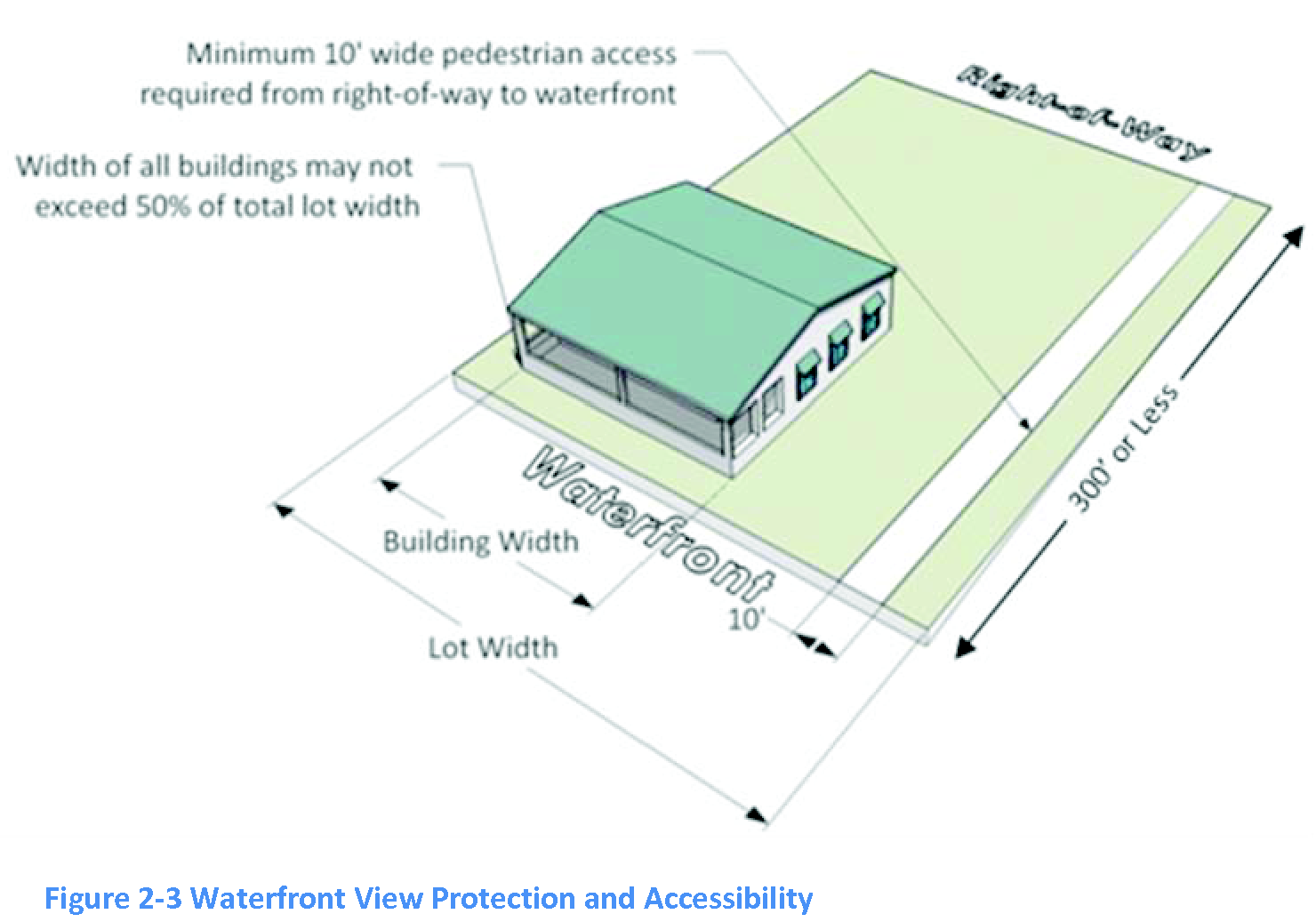
Waterfront view protection and accessibility. The following standards apply to any property abutting the waterfront:
a.
When the distance between the right-of-way and the waterfront is 300 feet or less, one pedestrian access way per property a minimum of ten-feet wide is required from the right-of-way directly to the waterfront.
b.
No single permanent structure or combination of permanent structures may encompass 50 percent or more of the total width of the lot.
9.
Signs.
a.
Signs in the PWD zoning districts shall comply with section 3.30 of the LUDC and the following:
• Materials on the face of any sign shall consist of wood, glass, metal, or any other material consistent with the principal building on the property or as approved as part of the development agreement.
• Plastic and similar synthetic materials are prohibited.
b.
Attached signs shall fit within the architectural space intended to accommodate signage, and shall not cover any architectural features.
c.
Signs that are viewed in relation to other signs shall be compatible with regard to location, shape, style, graphics, size, material, illumination, and color.
10.
Lighting. Lighting in the PWD zoning districts shall be designed by a certified lighting design specialist and comply with the following guidelines:
a.
Lighting levels and color for all non-single-family residential development shall be designed in such a manner as to consider the overall effect on patterns, repetition, focal points, and rhythm within the panorama of the riverfront within the PWD zoning districts.
b.
Building illumination and architectural lighting for all non-single-family residential development within the PWD zoning districts shall be indirect with no visible light source.
c.
Ground-level light fixtures for all non-residential development shall be of the burial-vault type or completely screened by landscape material.
d.
Illumination from any light source onto adjacent properties shall not exceed one-half foot-candle.
e.
The lighting of parking areas, access drives and vehicular circulation areas within non-single-family residential developments shall consist of full cut-off shield type fixtures mounted at the top of a pole. Poles and fixtures shall not exceed 20 feet in height, including the base, and shall be anodized bronze or black consistently throughout the pole.
f.
Light poles installed in association with non-single-family residential development shall be placed only in landscaped strips, buffers or planted islands.
g.
The minimum horizontal distance of any light pole from any side or rear property line is 20 feet.
F.
Miscellaneous provisions.
1.
Hours of operation. In order to address potential traffic, noise, or other nuisance impacts, the hours of operation for sales, deliveries, and services for uses on property located within 100 feet of residentially zoned or used property are limited from 8:00 a.m. to 9:00 p.m. Any extension of hours of operation beyond these times requires a special exception permit (see section 6.6.3).
2.
Outside sales or display. Exterior sales or display of goods may be allowed subject to the following limitations:
a.
The uses must be accessory to an approved primary use.
b.
Exterior sales or display areas are limited as follows:
(1)
To an area equal to 15 percent of the principal uses' gross floor area, or
(2)
Any approved boat sales/rental lots or plant nursery as provided in the development agreement.
c.
Exterior sales or display areas are not permitted in required landscape, parking, or pedestrian areas except as provided in the development agreement.
3.
Trash storage area screening requirements.
a.
If any trash storage area is located outside, it shall be:
(1)
Located or screened so as not to be visible from any public streets, and;
(2)
Screened when located within 100 feet of any one- or two-family residential structure.
b.
Screening may consist of a six-foot solid fence or wall, or a landscaped area with 100 percent opacity at the time of planting.
4.
Dry boat storage facilities. Refer to section 3.10.3 of the LUDC. Dry boat storage facilities are not allowed in the area defined as the riverfront overlay district in accordance with section 2.40, Table 2-5 (Table of Permitted Uses) and the comprehensive plan.
G.
Development permit review. A development permit application shall be submitted and reviewed pursuant to section 6.5.
H.
Bonuses for amenities. Residential densities, non-residential floor area ratios (FAR), and maximum building size in the planned waterfront development district may be increased beyond that permitted in section 2.15.D if the applicant provides the features set forth in Table 2-4 below. The quantity of amenities and percent bonuses described in Table 2-4 are guidelines, are not an entitlement to a particular amount of density or floor area. Any bonus shall be approved as part of the request for a rezoning and corresponding development agreement for the planned waterfront development district. The applicant may use any combination of bonuses but may not exceed the maximums set forth in Table 2-3.
Table 2-3, Maximum Residential Density, Non-residential Floor Area Ratio, and Building Size with Bonuses
Densities above 2.9 dwelling units/acre are permitted only if all of the following conditions exist:
• Existing residential density rights are distributed in an aggregated development. "Existing residential density rights" refers to the density allowed by any residentially zoned property that exists at time of a PWD rezoning application, and an "aggregated development" refers to the entire development that is subject to a PWD rezoning application; and
• The density rights are transferable within the PWD. The maximum residential density shall not exceed 6.7 dwelling units per acre regardless of any transfer of density. The development agreement shall describe the existing density rights, and the mechanism for transferring those rights throughout the PWD. Where property zoned MF-2 is rezoned to PWD along with property that was not zoned MF-2, the density rights from the MF-2 zoned property may be retained and utilized for the entire property zoned PWD. The density rights may be aggregated across the entire area encompassing the new PWD district, not just the area that was previously zoned MF-2.
For example: An applicant combines a two-acre parcel zoned MF-2 with a five-acre parcel zoned B-2, for a total of seven acres. The applicant may transfer the rights to have residential units to the entire seven-acre parcel (subject to the other requirements of this section) but may not exceed a density of 6.7 residential units per acre. Therefore, the maximum number of residential units on the seven-acre parcel is 46.9 (7 x 6.7).
• The development agreement provides a combination of the features listed in Table 2-4.
[1] The town council may grant an individual building or building(s) additional floor area up to 10,000 square feet if the increased building size(s) provide(s) a direct community benefit. A "community benefit" may include the reduction of noise impacts on adjacent properties, improved safety, and/or clustering of buildings in a manner that provides enhanced open areas, tree preservation and/or view corridors, or other acceptable public benefits as negotiated in the development agreements. The PWD rezoning application must include sufficient documentation (e.g., elevation drawings, perspective drawings, photographs, rendered graphical presentations, etc.) to demonstrate community benefit. The bonus allowed, if any, will relate to the degree of community benefit provided. The following are limited to 5,000 square feet (no floor area bonus is available):
• Dry boat storage buildings.
• Retail and/or service businesses (even if they are located in a building that is larger than 5,000 square feet). A "retail sales and/or service business" for this purpose means a separate structure or a building or tenant space sharing a common wall through which no access is allowed, but does not include boat construction and repair facilities.
For example: A PWD includes a building occupied by a boat sales business (which is classified as a recreational/working waterfront use) and a bookstore. The bookstore cannot occupy more than 5,000 square feet of floor area within the building. However, the boat sales business may occupy up to the entire building area.
Table 2-4, Bonuses for Amenities in the Planned Waterfront District
| Feature |
Residential
Density Bonus [1] (dwelling units per acre) |
Non-Residential
FAR Bonus (decimal increments above 0.35) |
Maximum
building area bonus [2] (additional floor area above 5,000 sf) | ||
|---|---|---|---|---|---|
| Recreational and Commercial Working Waterfront | 35% | 0.5 | 0.05 | 3,000 sf | |
| The percentage of shoreline allocated to Recreational and Commercial Working Waterfront exceeds: | |||||
 | 50% | 1.0 | 0.13 | 4,000 sf | |
| Shoreline Public Walkway | |||||
| A shoreline public walkway is provided along at least the following percentage of the shoreline frontage and dedicated as a pedestrian access easement bounded by at least one property line. At least one bench or seating area must be provided along at least every 150 feet of the walkway. |  | 35% | 1.0 | 0.05 | 2,000 sf |
| 50% | 1.5 | 0.08 | 2,500 sf | ||
| 70% | 2.0 | 0.13 | 3,000 sf | ||
| Additional Open Space | |||||
| Open space at ground level is increased by the following percent of the total upland lot area. Open space at ground level is provided in the form of pedestrian pathways or gathering spaces with benches or seating and made accessible to the public during reasonable hours. Open space does not include vehicular use areas or required landscaping, buffers, or designated protection zones. |  | 5% | 1.0 | 0.02 | 1,000 sf |
| 10% | 1.5 | 0.04 | 2,500 sf | ||
| Shade Trees | 1.5 | 0.02 | 1,000 sf | ||
| Shade trees are provided and maintained such that: |  | ||||
| 1. Shade trees are spaced along the adjacent or internal pedestrian networks no more than 25 feet apart; and | |||||
| 2. The total number of shade trees is at least 25% greater than the minimum number required by section 4.10. | |||||
| Mixed Use Buildings (40%-60% Residential) | 0.5 | 0.02 | 1,000 sf | ||
| Mixed use buildings in which residential uses occupy at least 40% and no more than 60% of the gross floor area. The following standards apply: |  | ||||
| 1. The ground floor must be reserved for Commercial Working Waterfront, Water Enhanced or General Retail uses. Residential uses that qualify for this bonus are limited to the second story or above; and | |||||
| 2. The applicant must use the Waterfront View Protection or Shoreline Pedestrian Walkway amenities (see description below); or | |||||
| 3. At least 15% of the dwelling units must be reserved for employees of businesses that are operating within any PWD. | |||||
| Waterfront View Protection |
30%
45% |
0.5
0.7 |
0.01
0.02 |
500 sf
1,000 sf | |
| The following minimum width of the lot along the shoreline, extending parallel along the length of the lot, is provided for waterfront view protection. This area is referred to as the "viewshed." |
60%
75% |
0.9
1.1 |
0.03
0.04 |
1,500 sf
2,000 sf | |
| The viewshed is not required to be continuous along the shoreline. However, the minimum required width of any viewshed is 30 feet. |  | ||||
| Structures that are no more than 3 feet high may be placed within a viewshed, and a vertical clearance of at least 10 feet must be maintained. The viewshed may include existing trees of no more than 3 feet DBH | |||||
[1]
Added to base density of 2.9 units/acre.
[2]
Only a single increment is awarded per bonus item, and not for each building on the development site.
For example: assume that a PWD initially proposes five buildings. Three buildings have 4,000 sf of floor area, and two have 5,000 sf. The applicant provides a viewshed for 75 percent of the shoreline, resulting in a building area bonus of 2,000 sf. The applicant may apply the 2,000 sf to a single building (for example, bringing one of the 4,000 sf buildings to 6,000 sf) or among multiple buildings (for example, dividing the 2,000 square feet equally to the 5,000 sf buildings, bringing each to 6,000 sf).
I.
Development agreements. All development in the planned waterfront development district requires a development agreement. The development agreement, along with the approved development plan (or concept plan with phased developments), governs land use and development of the proposed development within the PWD. Approval process is pursuant to section 6.6.15. Submittal contents are pursuant to sections 6.6.15 and 10.1.9.
J.
Reversion and rezoning. If the development is abandoned, or the town council finds that there is a material breach of the development agreement, the property shall revert to the zoning classification(s) in effect at the time of the application for rezoning to the PWD district. In the alternative, the town may rezone the property to another zoning classification that is appropriate at the time of abandonment or breach of the development agreement. In either situation:
1.
The director shall notify the applicant and the property owner, and
2.
The director shall revise the official zoning map to the former or new zoning classifications, and
3.
Any further development on the subject property shall comply with the former or new zoning classifications.
(Ord. No. 2013-08, § 2(Exh. A), 6-20-2013; Ord. No. 2020-02, § 3, 5-21-2020)
SECTION 2.16. - LOD (LIGHTHOUSE OVERLAY)
A.
Purpose and intent.
1.
Significance of the lighthouse. The Ponce de Leon Inlet Light Station, referred to herein as the "lighthouse" was completed in 1887 and following decades of restoration is a unique and historic structure of major significance to the people of the Town of Ponce Inlet. The lighthouse was designated a National Historic Landmark in 1998 and is the tallest lighthouse in Florida.
2.
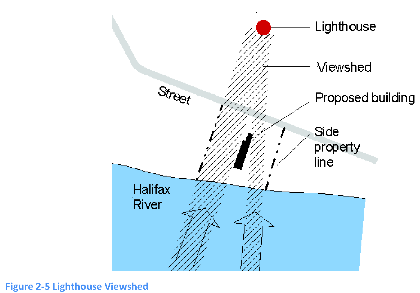
Purposes of the lighthouse overlay district. The lighthouse overlay district (LOD) is intended to provide supplementary regulations to an area surrounding the lighthouse to ensure that all significant vistas that include the lighthouse or surrounding historic grounds are preserved. Toward that purpose, this section defines the geographic extent of a lighthouse overlay district and establishes supplementary regulations within that district.
B.
Applicability.
1.
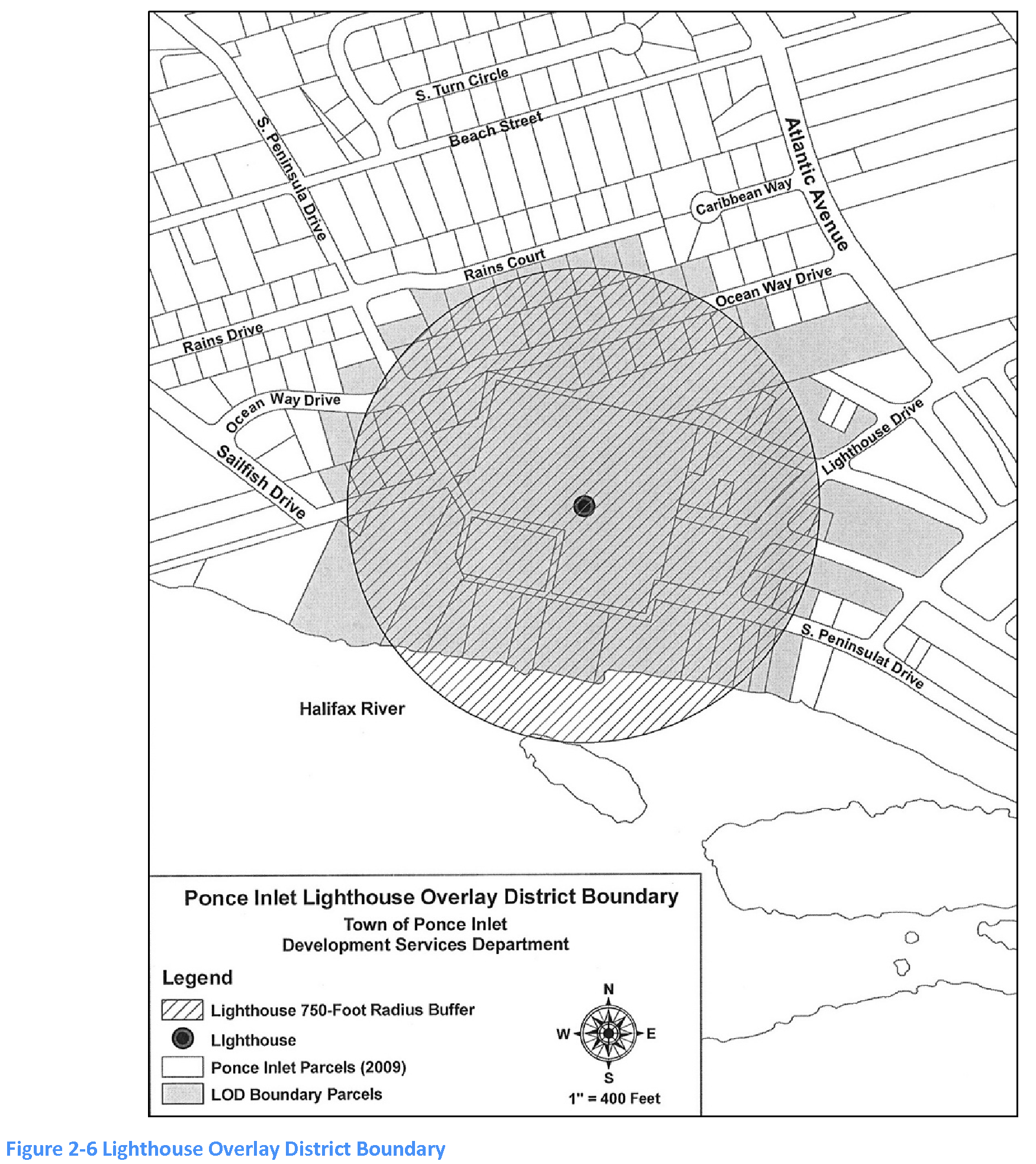
Generally. The LOD includes all parcels or areas within a 750-foot radius from the lighthouse (see the map included in this section that graphically depicts the extent of the LOD). All development and redevelopment within this area is subject to this section. If there is a conflict between these regulations and any other regulations, this section controls.
C.
Development and design standards.
1.
Building envelope. All nonresidential, multifamily, and townhome buildings in the lighthouse overlay district shall comply with the building envelope standards as follows:
2.
Maximum building width and spacing. All buildings located between any street and the Halifax River shall not exceed 55 feet in width.

The minimum spacing between the exterior walls of any two buildings (where allowed on the same lot) shall be 20 feet.
3.
Building design and materials. Standards for building design and materials for nonresidential, multifamily, and townhome buildings in the lighthouse overlay district are set forth in subsection 2.15.E, PWD regulations.
4.
Building orientation. Maintaining and enhancing views of the lighthouse from South Peninsula Drive as well as any other street within the LOD is required. The massing and placement of buildings and structures throughout the LOD shall provide for views of both the lighthouse and the Halifax River to the greatest extent possible.
5.
Signs. Signs in the LOD shall comply with section 3.30 of the LUDC and the following:
a.
Materials on the face of any sign shall consist of wood, glass, metal, or any other material consistent with the principal building on the property or approved as part of the sign permit review process. Plastic and similar synthetic materials are prohibited.
b.
Attached signs shall fit within the architectural space intended to accommodate signage, and shall not cover any architectural features.
c.
Signs that are viewed in relation to other signs shall be compatible with regard to location, shape, style, graphics, size, material, illumination, and color.

6.
Lighting. Lighting in the LOD shall comply with section 3.30 of the LUDC and the following:
a.
Lighting levels and color for all non-single-family residential development shall be designed in such a manner as to consider the overall effect on patterns, repetition, focal points, and rhythm within the panorama of the riverfront within the LOD.
b.
Building illumination and architectural lighting for all non-single-family residential development within the LOD shall be indirect with no visible light source.
c.
Ground level light fixtures for all nonresidential development shall be of the burial vault type or completely screened by landscape material.
d.
Illumination from any light source onto adjacent properties shall not exceed one-half foot-candle.
e.
The lighting of parking areas, access drives and vehicular circulation areas within non-single-family residential developments shall consist of full cut-off shield type fixtures mounted at the top of a pole. Poles and fixtures shall not exceed 20 feet in height, including the base, and shall be anodized bronze or black consistently throughout the pole.
f.
Light poles installed in association with non-single-family residential development shall be placed only in landscaped strips, buffers or planted islands.
g.
The minimum horizontal distance of any light pole from any side or rear property line is 20 feet.
7.
Utilities.
a.
All utility services (i.e., telephone, electricity, cable, etc.) shall be installed underground.
b.
All utility components required to be above-ground (i.e., transformers, meters, etc.) shall be screened by plant material or a decorative wall.
8.
Retaining walls, fences and railings.
a.
Retaining walls shall be faced with finished masonry or other decorative screening or landscaping to minimize the blank appearance of the walls.
b.
Fence and rail designs shall be compatible with the historic character of the LOD to the maximum extent practicable.
c.
All proposed walls and fences shall not restrict views to the lighthouse. However, this regulation does not apply where the wall or fence is necessary to restrict physical access to any area within the LOD for safety, security or to protect an environmentally sensitive area.
D.
Dry boat storage. Dry boat storage is subject to section 3.10.3 of the Land Use and Development Code.
E.
Development permits.
1.
Applications for development permits in the LOD shall be reviewed for compliance with the following:
a.
The proposed development is consistent with the purpose and intent of the LOD.
b.
The proposed development is consistent with Ponce Inlet's Comprehensive Plan.
c.
The site is physically suitable for the project design and its construction phase.
d.
The proposed development minimizes and reduces to the greatest extent possible and where applicable, visual impacts and obstructions to the lighthouse from both the Halifax River and the land area within the LOD boundary.
e.
The architectural style and building scale of any proposed development reflect the historic setting and unique character of this geographic area.
2.
For any proposed development between Sailfish Drive or S. Peninsula Drive and the Halifax River, an application for a development permit shall show the viewshed from the lighthouse to the Halifax River.
F.
Development agreements.
1.
An applicant may provide a development agreement that includes modifications to any development or design standard established in subsections 2.16.C.2 through 2.16.C.8. The development agreement, along with the approved development plan, will govern land use and development of the proposed development within the lot. Approval process and submittal contents are pursuant to section 6.6.13.
2.
The development agreement shall be approved prior to or concurrent with the final approval of any development permit required for the proposed development.
3.
If the development is abandoned, all development pursuant to the development agreement shall cease, and:
a.
The director shall notify the applicant and the property owner, and
b.
The director shall revise the official zoning map to the former or new zoning classifications, if required, and
c.
Any further development on the subject property shall comply with the current provisions of this code.
SECTION 2.17. - AZD (AIRPORT ZONING OVERLAY DISTRICT)
A.
Purpose. The purpose of this section is to establish reasonable airport zoning regulations to implement the provisions of state and federal law relating to airport zoning; to provide for airspace protection and land use compatibility with airport operations; to protect the public health, safety and welfare in the vicinity of an airport by minimizing the exposure to hazards and noise levels generated by aircraft operations; to facilitate proper land use planning and to prohibit the location of incompatible land uses and structures in areas surrounding existing or future airports; to provide a process to issue or deny permits and enforcement thereof for airport obstructions; to provide for coordination and notification of airport protection permitting between local government jurisdictions; and to provide for coordination of permit applications between the town and state.
B.
Definitions.
Aeronautical study: A Federal Aviation Administration study, conducted in accordance with the standards of 14 C.F.R. part 77, subpart C, and Federal Aviation Administration policy and guidance, on the effect of proposed construction or alteration upon the operation of air navigation facilities and the safe and efficient use of navigable airspace.
Airport: Any area of land or water designed and set aside for the landing and taking off of aircraft and used or to be used in the interest of the public for such purpose.
Airport elevation: The highest point of an airport's usable landing area measured in feet above mean sea level.
Airport hazard: An obstruction to air navigation which affects the safe and efficient use of navigable airspace or the operation of planned or existing air navigation and communication facilities.
Airport hazard area: Any area of land or water upon which an airport hazard might be established.
Airport layout plan: A set of scaled drawings that provide a graphic representation of the existing and future development plan for the airport and demonstrate the preservation and continuity of safety, utility, and efficiency of the airport.
Decision height: The height at which a decision must be made during all ILS instrument approach to either continue the approach or to execute a missed approach.
Educational facility: Any structure, land, or use that includes a public or private kindergarten through 12 th grade school, charter school, magnet school, college campus, or university campus. The term does not include space used for educational purposes within a multi-tenant building.
Ldn: A day/night 24-hour average sound level measurement, expressed in decibels, obtained after addition of ten decibels to sound levels occurring during the nighttime period from 10:00 p.m. to 7:00 a.m.
Minimum descent altitude: The lowest altitude, expressed in feet above mean sea level, to which descent is authorized on final approach or during circling-to-land maneuvering in execution of a standard instrument approach where no electronic glide slope is provided.
Nonconforming use: For purposes of airport protection and land use compatibility regulations in this section, any preexisting structure, object of natural growth or use of lands which is inconsistent with the provisions therein.
Obstruction: Any existing or proposed object, terrain, or structure construction or alteration that exceeds the federal obstruction standards contained in 14 C.F.R. part 77, subpart C that obstructs the airspace required for flight of aircraft in landing and takeoff at an airport or is otherwise hazardous to such landing or takeoff of aircraft. The term includes: Any object of natural growth or terrain; permanent or temporary construction or alteration, including equipment or materials used and any permanent or temporary apparatus; or alteration of any permanent or temporary existing structure by a change in the structure's height, including appurtenances, lateral dimensions, and equipment or materials used in the structure.
Precision instrument runway: A runway having an instrument approach procedure utilizing an instrument landing system (ILS) or a precision approach radar (PAR). It also means a runway for which a precision approach system is planned and is so indicated on an FAA-approved airport layout plan; a military service's approved military airport layout plan; any other FAA planning document, or military service's military airport planning document.
Public-use airport: An airport, licensed by the state, which is open for use by the public. For the purposes of this section, the public-use airport is the New Smyrna Municipal Airport (EVB).
Runway: A defined area on an airport prepared for landing and takeoff of aircraft along its length.
Runway protection zone: An area at ground level beyond the runway end to enhance the safety and protection of people and property on the ground.
Visual runway: A runway intended solely for the operation of aircraft using visual approach procedures with no straight-in instrument approach procedures and no instrument designation indicated on an FAA-approved airport layout plan, a military-services-approved military layout plan, or by any planning document submitted to the FAA by competent authority.
C.
Airport zoning overlay district (AZD). In order to carry out the provisions of this section, there are hereby created and established certain "protected surface zones" that include all lands and upland parcels within the municipal boundary of the town lying beneath the primary, approach, transitional, horizontal, and conical surfaces of the New Smyrna Beach Municipal Airport, as depicted graphically on the map included in this section. The airport zoning overlay district regulations shall apply in addition to the established zoning districts on such lands and upland parcels pursuant to article 2 of this code. The zones, or portions thereof, within this overlay district to which these regulations apply are as follows:
1.
Primary zone. A rectangular area located at each end of a runway, longitudinally centered on the runway. For hard surface runways, the primary surface extends 200 feet beyond each end. For runways without a hard surface, the primary zone ends at each runway end. The width depends on the existing or planned approach and runway type, as follows:
a.
Precision Instrument Runways: 1,000 feet.
b.
Non-Precision Instrument Runways: 500 feet.
c.
Public Utility Visual Runways: 250 feet.
d.
Private Utility Visual Runways: 100 feet.
No structure or obstruction that is not part of the landing and takeoff area and is of a greater height than the nearest point on the runway centerline will be permitted within the primary zone.
2.
Runway protection zone. A trapezoidal area at ground level beginning 200 feet beyond the end of a runway and centered about the extended runway centerline, with the shortest side of the trapezoid closest to the runway. The runway protection zone dimension for a particular runway end is a function of the type of aircraft and approach visibility minimum associated with that runway end. Its width corresponds to that approach zone. Its length varies as follows:
a.
Precision Instrument Runways: 2,500 feet.
b.
Non-precision Instrument Runways: 1,000—1,700 feet.
c.
Public Utility Visual Runways: 1,000 feet.
3.
Horizontal zone. An area around each airport with an outer boundary, the perimeter of which is constructed by swinging arcs or specified radii from the center of each end of the primary zone of the airport's runways and connecting the adjacent arcs by lines tangent to those arcs. The radius for each arc for the horizontal surface is 5,000 feet for visual approach runways, and 10,000 feet for all other approach types. The horizontal zone extends outward from the transitional zone to the edge of the conical zone. No structure or obstruction can extend 150 feet above the established airport elevation.
4.
Conical zone. The area extending outward from the periphery of the horizontal zone for a distance of 4,000 feet. Height limitations on structures or obstructions begin at 150 feet above the established airport elevation at the inner edge, with permitted height increasing one foot vertically for every 20 feet of horizontal distance.
5.
Approach zone. An area longitudinally centered on the extended runway centerline, and extending outward and upward from the end of the runway's primary surface. The approach surface begins at the end of the primary surface. An approach zone is designated for each runway based upon the type of approach available or planned for that runway end. Permitted height limitation within the approach zones is the same as the runway end height at the inner edge and increases with horizontal distance outward from the inner edge as follows:
a.
Precision Instrument Runway: Permitted height increases one foot vertically for every 50 feet horizontal distance for the first 10,000 feet and then increases vertically for every 40 feet horizontal distance for an additional 40,000 feet.
b.
Non-precision instrument runways: Permitted height increases one foot vertically for every 34 feet horizontal distance for a total distance of 10,000 feet.
c.
Visual runways: Permitted height increases one foot vertically for every 20 feet horizontal distance for a total distance of 5,000 feet.
6.
Transitional zone. The area extending outward and upward at a 7:1 slope from the sides of the primary zones and approach zones connecting them to the horizontal zone. Height limits within the transitional zone are the same as the primary zone or approach zone at the boundary line where it adjoins and increases at a rate of one foot vertically for every seven feet horizontally, extending out at right angles to the runway center line and extended center line for a distance of 5,000 feet.
D.
Airport land use compatibility restrictions. Notwithstanding any other provision of this chapter, no use may be made of land or water within any zones established by this section in such a manner as to interfere with the operation of an airborne aircraft. The following special requirements shall apply to each permitted use:
1.
Prohibited uses. Notwithstanding the uses permitted in the underlying zoning districts as provided in article 2, the following uses are prohibited within any runway protection zone:
Community residential homes.
Detached single-family dwellings.
Group homes.
Multifamily dwellings.
Schools and educational facilities.
Storage of explosive material.
Townhouses.
Two-family dwellings.
Uses that assemble large groups of people or any other use that could produce a major catastrophe as a result of an aircraft crash.
2.
Lighting. On non-single-family residential properties, all lights or illumination used in conjunction with street, parking, signs or other uses of land and structures shall be arranged and operated in such a manner that it is not misleading or dangerous to aircraft operating from a public airport or in the vicinity thereof, by shielding, directing downwards, or other means as necessary.
3.
Height. Notwithstanding the preceding provisions in this section, the owner of any structure over 200 feet above ground level shall install lighting in accordance with Federal Aviation Administration Advisory Circular 70-7460-1D, and amendments thereto, on such structure. Additionally, high intensity white obstruction lights shall be installed on a high structure which exceeds 749 feet above mean sea level. The high intensity white obstruction lights must be in accordance with Federal Aviation Administration Advisory Circular 70-7460-1D, and amendments thereto.
4.
Visibility/glare. No operations from any type shall produce smoke, glare or other visual hazards that endanger or interfere with the landing, takeoff, or maneuvering of aircraft intending to use the airport.
5.
Airport noise zones.
a.
No new noise-sensitive land uses shall be established within the limits of the 65-L dn /DNL noise exposure contour as delineated in the most current 14 CFR part 150 Airport Noise Compatibility Study in effect at the time of a development proposal. Noise-sensitive land uses include, but are not limited to: single family residential, multi-family residential, civic assemblies, schools (with the exception of aviation schools), group homes, day care centers, and museums. A complete listing of land use types by their compatibility with aircraft-related noise levels is set forth under 14 CFR Part 150, Appendix A, and is incorporated herein by reference.
b.
Expansion, replacement, or renovation (with a cost at least 60 percent of the existing assessed value) of an existing noise-sensitive use or structure within the 65 DNL noise exposure contour may be approved if:
(1)
The work incorporates building techniques and materials that will result in a 25-decibel reduction between the exterior noise level and that inside the structure; or
(2)
The owner/developer voluntarily provides a recorded avigation easement for noise with non-suit covenant running with the land in a format acceptable to the town.
c.
If a noise study has not been conducted, residential construction and any educational facility, with the exception of aviation school facilities, shall be prohibited within an area contiguous to the airport measuring one-half the length of the longest runway on either side of and at the end of each runway centerline.
d.
Subsection 5 may not be construed to require the removal, alteration, sound conditioning, or other change, or to interfere with the continued use or adjacent expansion of any educational facility or site in existence as of July 1, 1993.
6.
Wildlife hazard attractants. Landfills, waste disposal facilities, and other facilities that store, handle, or process organic or any other material that foster or harbor the growth of insects, rodents, amphibians, or other organisms that result in significant bird population increases above the normal background level, as well as stormwater management facilities, wetlands, and other areas containing aquatic life and vegetation also attract birds and other wildlife that may increase the potential for aircraft bird strikes, resulting in damage to aircraft and injury to occupants shall be subject to the following regulations:
a.
New landfills shall not be located:
(1)
Within 10,000 feet of the nearest point of any runway to be used by turbine aircraft; or
(2)
Within 5,000 feet from the nearest point of any runway used by only non-turbine aircraft.
(3)
Outside the perimeters described in subparagraphs (1) and (2) above, but within the lateral limits of the civil airport imaginary surfaces as defined by federal regulations, as amended from time to time, for approaching, departing, and circling aircraft.
b.
All proposed and existing landfills shall be reviewed to determine whether they attract or sustain hazardous bird movements from feeding, water, or roosting areas into or across the runways or approach and departure patterns of aircraft. The existence of such hazards shall be considered in deciding whether to permit a proposed landfill, and whether to require an existing or proposed landfill to use bird management techniques or other practices to minimize bird hazards to airborne aircraft.
c.
Above-ground stormwater management facilities, including open water features, canals, marsh areas, dry detention, and littoral zone areas should not be placed within airport operations areas due to their aquatic and vegetative environments and potential to attract wildlife. Where such facilities are unavoidable, best management practices shall be used to decrease the potential to attract wildlife, such as steep slopes, rip-rap lined detention areas, vegetation managements, and use of dry detention areas, subject to development plan review procedures in section 6.6.6.
E.
Permitting.
1.
Administration and enforcement. It shall be the duty of the Director to administer and enforce the requirements prescribed herein within the overlay district of the town through the permitting process.
2.
Permit required. Any person proposing to construct, alter, or allow an obstruction in an airport hazard area, as determined by the FAA, must apply for a building or development permit, as applicable. Such permit may not be issued if it would allow the establishment or creation of an airport hazard or if it would permit a nonconforming obstruction to become a greater hazard to air navigation than it was when the applicable airport protection zoning regulation was adopted which allowed the establishment or creation of the obstruction, or than it is when the application for a permit is made.
3.
Permit application. In addition to the standard submittal documents associated with a building or development permit application, permit applications under this section shall include documentation showing compliance with the federal requirement for notification of proposed construction or alteration of structures and a valid aeronautical study. All such applications shall be accompanied by the appropriate review fee established by council resolution.
4.
Review criteria. The following criteria shall be considered when determining whether to issue or deny a permit:
a.
The safety of persons on the ground and in the air;
b.
The safe and efficient use of navigable airspace;
c.
The nature of the terrain and height of existing structures;
d.
The effect of the construction or alteration on the state licensing standards for a public-use airport contained in F.S. Chapter 330, and rules adopted thereunder;
e.
The character of existing and planned flight operations and developments at public-use airports;
f.
Federal airways, visual flight rules, flyways and corridors, and instrument approaches as designed by the Federal Aviation Administration;
g.
The effect of the construction or alteration of an obstruction on the minimum descent altitude or the decision height at the affected airport; and
h.
Comments provided by affected municipal jurisdictions, if any.
F.
FDOT review. Upon receipt of a complete permit application, a copy of the application shall be provided to the Florida Department of Transportation Aviation Office by certified mail, return receipt requested, or by a delivery service that provides a receipt evidencing delivery. Pursuant to F.S. § 333.025(4), the Department of Transportation shall have 15 days to review the application and provide comments, if any, to the town, said time running concurrently with the review of the application by the town.
G.
Hazard marking and lighting. The owner of a permitted obstruction shall be required to install, operate, and maintain thereon, at his or her own expense, marking and lighting in conformance with the specific standards set forth by the Federal Aviation Administration.
H.
Nonconforming uses. This section may not require the removal, lowering, or other change or alteration of any obstruction not conforming to the regulation when adopted or amended, or otherwise interfere with the continuance of any nonconforming use, except as provided in subsection E above.
I.
Abandonment. A nonconforming obstruction that has been abandoned or is more than 80 percent torn down, destroyed, deteriorated, or decayed shall not be granted a permit if it would allow the obstruction to exceed the applicable height limit or otherwise deviate from the airport protection zoning regulations. Whether or not an application is made for a permit under this subsection, the owner of the nonconforming obstruction may be required, at his own expense, to lower, remove, reconstruct, alter, or equip such obstruction as may be necessary to conform to the current airport protection zoning regulations. If the owner of the nonconforming obstruction neglects or refuses to comply with such requirement for ten days after notice, the town may proceed to have the obstruction so lowered, removed, reconstructed, altered, or equipped, and assess the cost and expense thereof upon the owner of the obstruction or the land whereon it is or was located.
J.
Variances and modifications. Unless otherwise provided in this section, a petition for variance from the requirements of this section shall be governed by the provisions of section 6.6.4.
K.
Exemptions. Notwithstanding any other provisions herein, the following activities and structures shall be exempt from the permitting requirements of this section:
1.
Existing structures that received construction permits from the Federal Communications Commission that exceed federal obstruction standards before May 20, 1975. A permit is not required for any necessary replacement or repairs to such existing structures if the height and location are unchanged.
2.
Non-substantial improvements of existing residential structures and parcels, and non-residential structures or parcels provided the principal use of the property has not been discontinued for a period of no less than 180 consecutive days.
3.
Cranes, construction equipment, and other temporary structures in use or in place for a period not to exceed 18 consecutive months are exempt from review by the Florida Department of Transportation, unless requested by FDOT.
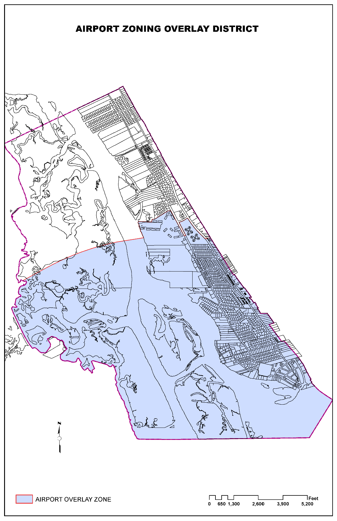
(Ord. No. 2018-12, § 3, 9-20-2018)
2.2.1 - Applicability.
A.
This article applies uniformly to all premises.
B.
This article applies to:
1.
The use or occupancy of any premises,
2.
The erection, construction, movement or alteration of any principal building or accessory structure.
2.3.1 - Identification of official zoning map.
A.
The official zoning map shows the boundaries of each zoning district.
B.
The planning and development department director is authorized to prepare the official zoning map.
C.
The director is the custodian of the official zoning map. The official zoning map is located in the office of the director.
D.
The official zoning map is identified by the signature of the mayor, and is attested by the town manager and the town seal under the following words: "This is to certify that this is the Official Zoning Map referred to in article 2 of the Town of Ponce Inlet's Land Use and Development Code (LUDC)."
E.
The planning and development department enters adopted changes to the zoning district boundaries or other matters portrayed on the official zoning map promptly after the amendment becomes effective.
F.
Regardless of the existence of purported copies of the official zoning map that are made or published, the official zoning map is the final authority as to the current zoning of land and water areas, buildings and other structures in the town.
G.
The boundaries of individual zoning districts shall be interpreted as per article 9, section 9.1 of this code.
2.40.1 - Interpretation of uses and structures permitted.
A use or structure that is not expressly permitted in a zoning district is prohibited.
Table 2-5, Table of Permitted Uses
(Ord. No. 2014-05, § 3, 7-17-2014; Ord. No.2018-01, § 1, 1-18-2018; Ord. No. 2022-07, § 2, 11-17-2022; Ord. No. 2024-06, § 2(Exh. A), 11-21-2024)