
Ponce Inlet City Zoning Code
ARTICLE 4
DEVELOPMENT STANDARDS
SECTION 4.10. - TREE AND NATIVE VEGETATION PRESERVATION, BUFFERS AND LANDSCAPE REQUIREMENTS[1]
Editor's note— Ord. No. 2014-04, § 2(Exh. B), adopted July 17, 2014, amended Section 4.10 in its entirety to read as herein set out. Former Section 4.10, §§ 4.10.1—4.10.6, pertained to similar subject matter, and derived from Ord. No. 2012-15, adopted Dec. 20, 2012.
SECTION 4.11. - WATERFRONT PROPERTIES
In any residential zoning district, waterfront properties are subject to the following restrictions:
4.1.1 - Generally.
This article establishes standards for the development and improvement of property. This includes standards for infrastructure and improvements, site design and layout, protecting a development and its surrounding neighborhood from negative environmental impacts, including impacts on the listed protected and endangered wildlife species, and other related issues.
(Ord. No. 2019-03, § 2, 4-18-2019)
4.1.2 - Applicability.
This article applies to any development order or development permit, unless stated otherwise.
4.2.1 - Required improvements.
A.
The following improvements are required within all developments:
1.
Survey reference markers.
2.
Street grading, base preparation, surface course, and curb and gutter.
3.
Storm drainage/retention systems.
4.
Sidewalks.
5.
Sanitary sewage collection systems.
6.
Potable water distribution systems.
7.
Street name markers and traffic control signs.
8.
Bridges.
9.
Street lighting.
10.
Landscaping.
B.
In addition, any unpaved streets which provide access to a development from a paved street shall be improved by the developer in accordance with the specifications in this section.
C.
When approving subdivision plats and site plans of property abutting substandard rights-of-way, the town shall determine whether factors exist, such as drainage, swales, or other conditions which make widening of the right-of-way unfeasible. If the right-of-way can be widened, the town shall consider whether: (1) the approved plat or site plan will generate increased need for the widened right-of-way; and (2) it is economically feasible to construct a widened right-of-way to include sidewalks and/or bike paths, within 12 months after the approval of the plat or site plan. As a condition of approval, the town may require the applicant of a subdivision plat or site plan to dedicate one-half of the additional width required to bring the right-of-way to minimum standards set forth herein. In no event, however, shall the town require dedication which constitutes an unconstitutional taking of private property.
4.2.2 - Design and construction of required improvements.
All improvements shall be installed in accordance with the standards and specifications in this article. The developer shall provide all improvements, dedications, performance guarantees and maintenance guarantees required by the LUDC.
The town engineer shall:
1.
Review and inspect all improvements except sanitary sewer and private utilities for compliance with the approved plans and specifications, and
2.
Issue a certificate of completion upon the approved completion of the work subject to the required maintenance period.
The City of Port Orange Director of Utilities shall:
3.
Review and inspect the sanitary sewer system for compliance with the approved plans and specifications and applicable ordinances and resolutions of the City of Port Orange, and
4.
Issue a certificate of completion upon the approved completion of the work subject to the required maintenance period.
The engineer of record shall certify in writing that the improvements are completed in accordance with the approved plans and specifications. No certificates of occupancy shall be issued within the development until the town has accepted all required improvements.
4.2.3 - Permanent survey reference monuments.
Permanent survey reference monuments shall be installed in all subdivisions in accordance with F.S. ch. 177 and chapter 5J-17, Florida Administrative Code. The professional land surveyor and mapper shall establish the elevation in feet above National Vertical Geodetic Datum (N.V.G.D.) for at least two permanent reference monuments in the subdivision, and show such information on the plat.
4.2.4 - Survey accuracy.
The allowable angular error of closure and linear error of closure for surveys shall be in accordance with chapter 5J-17, Florida Administrative Code.
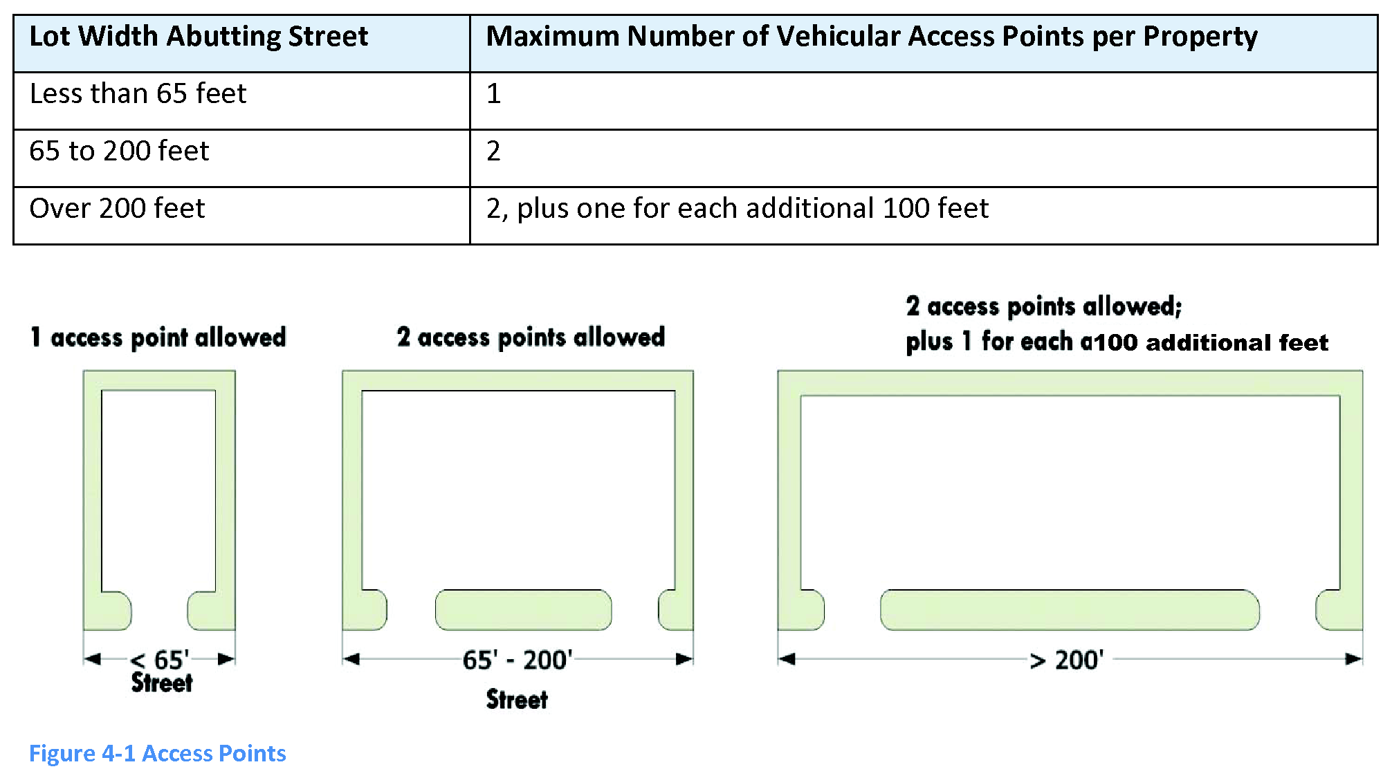
4.2.5 - Access control.
No curb, parkway, or sidewalk shall be cut or altered and no point of access or opening for vehicles onto a public street shall be established without a permit issued by the director. For any point of access or opening onto a county-maintained road, a permit issued by the county is also required.
A.
Application and plans. Applications for a driveway or access to a public street shall be made to the director and shall include plot plans of the property to be used for driveway and parking purposes.
B.
Number of access points. The maximum number of vehicular access points permitted onto any one street per property shall be as follows:
Table 4-1 Access Points
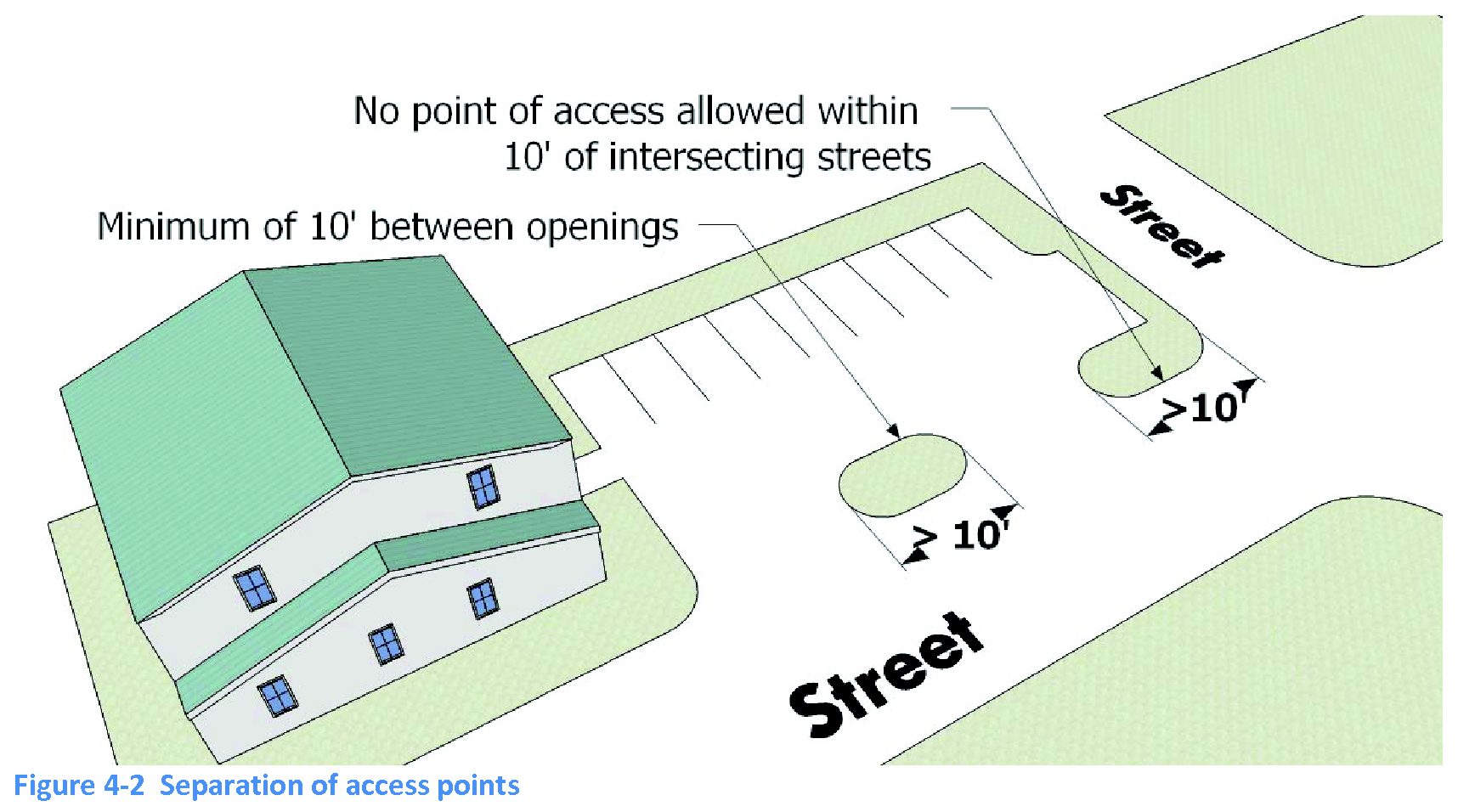
C.
Location of driveways.
1.
A minimum of ten feet is required between any two openings on the same street for any one use.
2.
No point of access is allowed within ten feet of the intersection of the right-of-way lines of two public streets.
3.
Where right-of-way lines intersect in the form of an arc, the required ten feet shall be established as near as practical to the center of the arc.
4.
The location and width of driveways shall be established by measurements taken along the property line.
D.
Single-family residential driveway widths.
1.
Driveways serving individual single-family residences shall not exceed 24 feet in width. Width is measured at the property line.
2.
Driveway entrances shall have at least a 30-degree flare between the property line and the curb, or if no curb, the traveled street. This provides for the turning arc of vehicles entering and leaving the abutting property.
E.
Multifamily and nonresidential driveway widths.
1.
Driveways serving multifamily developments and any nonresidential development or use shall be between 20 to 30 feet in width. This distance is measured at the property line.
2.
Driveway entrances shall have a ten- to 20-foot radius between the property line and the curb, or if no curb, the traveled street. This provides for the turning arc of vehicles entering and leaving the abutting property.
F.
Driveway materials. That portion of any driveway which is on the public right-of-way shall be constructed of concrete or other approved permanent paving material, in accordance with specifications established by the town, if the driveway opens onto a paved street.
4.2.6 - General street layout.
A.
Proposed streets within developments shall be laid out with consideration of existing and planned streets in the surrounding area, topographical conditions, public convenience and safety, and the proposed use of land to be served by the streets.
B.
Streets shall conform to the transportation element of the town's comprehensive plan and other official maps or plans of the town.
C.
Where the town determines it is necessary to provide street access to an adjoining property, proposed streets shall be extended by dedication to the boundary of the property, and a temporary turnaround provided.
D.
The proposed arrangement of streets shall connect to existing streets in adjoining areas.
4.2.7 - Public/private streets.
All streets shall be public unless private streets are approved by the town council upon recommendation of the director of planning and development, town engineer and town attorney. The town council shall not approve a private street in a proposed development if it can be reasonably assumed that the street is needed to serve the area adjoining the proposed development. All public streets shall be dedicated to the perimeter of the proposed subdivision unless they are permanently terminated by a cul-de-sac or an intersection with another street. Private streets shall be designed and constructed to the same standards as public streets, in accordance with the Town of Ponce Inlet Standard Construction Details. Rights-of-way intended for streets, water mains, sanitary sewers, storm drains, or any other use involving maintenance by the town shall be dedicated to public use by the developer and shown on the plat on which the right-of-way is established.
4.2.8 - Street names.
A.
A proposed street that aligns with another existing and named street shall bear the assigned name of the existing street.
B.
Except as provided in subsection A, the name of a proposed street shall not duplicate or be phonetically similar to the assigned name of an existing street in Volusia County. This applies whether or not a suffix is used (e.g., street, avenue, boulevard, drive, place, court, etc.).
4.2.9 - Design standards for streets.
This section establishes the minimum standards for street design. This section applies to both public and private streets. Street classification is specified in the comprehensive plan.
A.
Right-of-way widths.
Table 4-2 Right-of-Way Widths
B.
Street paving.
1.
All street paving shall conform to the town's specifications in the adopted standard construction details manual.
2.
Streets shall be installed by a contractor licensed to do paving work in the State of Florida.
3.
All paving materials used shall be obtained from a plant approved by the town engineer.
C.
Paving widths. Minimum street pavement widths measured from back of curb to back of curb are as follows:
Table 4-3 Paving Widths
D.
Centerline grade. The centerline grade for all streets shall conform to the applicable provisions of the "Manual of Uniform Minimum Standards for Design, Construction and Maintenance for Streets and Highways," State of Florida Department of Transportation.
E.
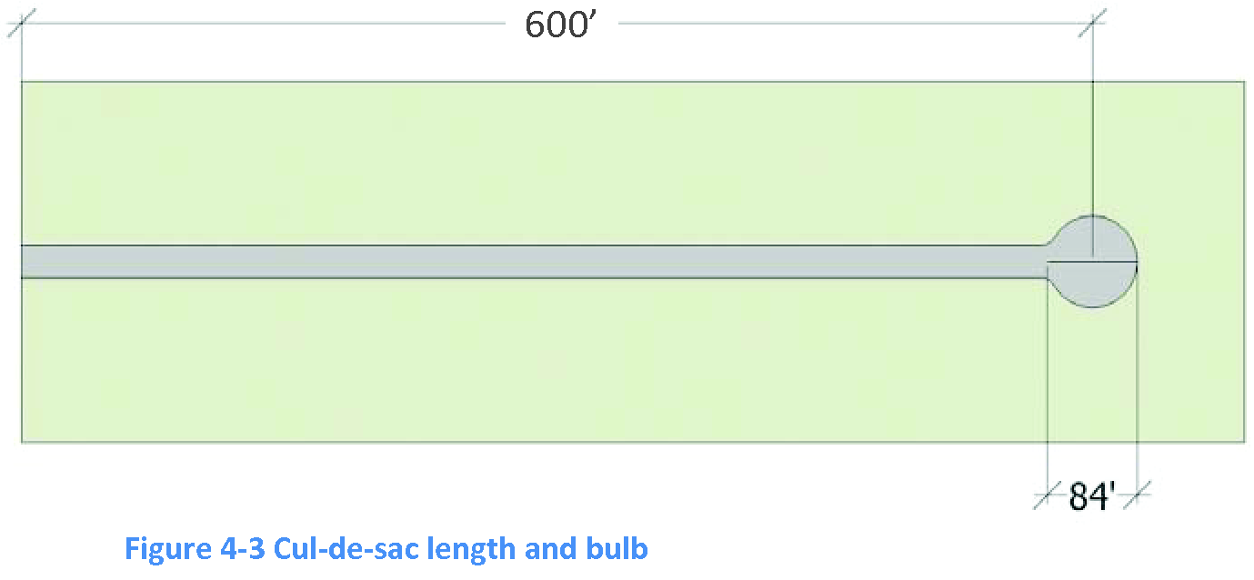
Culs-de-sac (permanent and temporary).
1.
The maximum length of a cul-de-sac is 600 feet. This distance is measured along the centerline from the nearest right-of-way line of the intersecting street to the center point of the turnaround.
2.
Turnaround area shall have a right-of-way diameter of at least 100 feet and a minimum paved surface diameter of 84 feet including curbs.
3.
A landscaped island is permitted in the center of the turnaround (maximum diameter of 32 feet). When a landscaped island is proposed, the developer shall establish by deed covenants or some other means acceptable to the town an entity to assume legal and financial responsibility for the perpetual maintenance of the landscaped area. As an alternative, the town may elect to accept maintenance of the landscaped islands and may establish a special assessment district or other means for assessment of fees to cover the reasonable costs of maintenance.
F.
Horizontal curves. Where a centerline deflection angle of more than two degrees occurs, a circular curve shall be inserted having a centerline radius of at least the following:
Table 4-5 Horizontal Curves
G.
Intersections.
1.
Streets shall intersect at an angle of approximately 90 degrees, unless circumstances make it necessary to allow a lesser angle of intersection. In no case shall the angles of intersection be less than 60 degrees.
2.
Street jogs or centerline offsets between streets shall not be less than 150 feet.
3.
Street curblines (or pavement edge) at all typical right-angle intersections shall be rounded with a minimum radius as follows:
Table 4-6 Street Curbline Radii
The town council may, upon a recommendation from the town engineer, require other appropriate radii for other than right-angle intersections.
H.
Bridges.
1.
Bridges shall be designed and constructed to comply with the standards and criteria for geometry and loading in the latest edition of the American Association of State Highway and Transportation Officials, "Standard Specifications for Highway Bridges."
2.
The load criteria shall comply with the State of Florida "Manual of Uniform Minimum Standards for Design, Construction, and Maintenance For Streets and Highways."
3.
Prior to design of bridges, the developer shall submit design load criteria to the town engineer for approval.
4.
Bridges shall be constructed with curbs along the pavement edge.
5.
Sidewalks at least four feet wide shall be constructed on both sides.
6.
Approach guardrails shall be provided where deemed by the town engineer to be necessary for safety.
4.2.10 - Street construction standards.
All streets, both public and private, shall be constructed in accordance with the following minimum standards:
A.
Grading and landscaping. All rights-of-way other than the roadway area shall be sodded. Unless special ditch protection is required due to high velocities, the following will be the standard protection for ditches unless engineering calculations indicate the need for an exception:
Table 4-7 Street Grading and Landscaping
B.
Pavement subgrade.
1.
Subgrade is that portion of the roadbed immediately below the base course of pavement including below the curb and gutter. The limits of subgrade are considered to extend to a depth of six inches below the bottom of the base for local streets and 12 inches below the bottom of the base for collector streets and outward to 12 inches beyond the curb.
2.
The stabilizing material, if any is required, shall be high-bearing value soil, sand-clay, limerock, shell, or other material approved by the town engineer. Where the existing soils to be used in the roadway subgrade have the required bearing value, no additional stabilizing material need be added or mixed in.
3.
A stabilized subgrade shall be constructed to support the curb and pavement base and shall be stabilized to not less than 75 pounds Florida Bearing Value (FBV) or at least 40 pounds Limerock Bearing Ratio (LBR) to a six-inch minimum depth. A compaction of 98 percent of maximum density (AASHTO T-180) shall be required.
4.
Tests for the subgrade bearing capacity and compaction shall be located no more than 300 feet apart and shall be staggered to the left, right and on the centerline of the roadway. When the town engineer determines that conditions warrant additional testing to ensure compliance with the specifications, the developer's engineer will be advised in writing. Test results shall be submitted to the town engineer.
C.
Pavement base.
1.
Bases for all local streets shall have a six-inch depth. Bases for all collector streets shall have an eight-inch depth.
2.
Portland cement, concrete, limerock, or full-depth asphalt pavement may be used. Soil cement is not permitted
3.
Mix designs shall be submitted to the town engineer for approval prior to the start of subgrade preparation. Cement delivery tickets shall be provided for the town engineer at the time of placement.
4.
Testing of the in-place base shall be at intervals equivalent to subgrade testing and shall consist of a minimum of moisture content tests and compaction tests. Test results shall be submitted to the town engineer.
5.
All base and roadway designs shall be subject to the approval of the town engineer.
6.
The pavement base shall be crowned a minimum of one-quarter inch per foot.
7.
Design mixes shall be submitted to the town engineer at least three working days prior to any construction of roadway bases.
8.
The town engineer may review and approve, conditionally approve, or deny base and roadway designs and design mixes.
D.
Pavement surface.
1.
Asphalt specifications shall be submitted by the developer's engineer with final plans. Florida state-certified batch plants must certify that approved specifications have been met.
2.
Pavement crown shall be one-quarter inch per foot or greater. Finish pavement shall be one-quarter inch higher than the lip of any concrete gutter. Asphalt surface course thickness shall be 1¼ inches after compaction.
3.
Testing of the density of the asphalt surface shall be at intervals as given under pavement subgrade. Gradation and asphalt extraction test results shall also be provided to the town engineer. Core borings shall be required to verify the thickness of the base and surface courses.
4.
The developer shall provide all required street striping and markings on all new roadways according to the approved development plans.
E.
Concrete curb.
1.
A curb shall be provided on both sides of all streets.
2.
Valley curbs shall be 24 inches wide and a minimum of six inches thick.
3.
Ribbon curbs, provided in association with swale drainage, shall be six inches wide and 18 inches deep.
4.
Concrete shall have a minimum 28-day compressive strength of 2,500 pounds per square inch.
5.
Curbs shall be saw-cut at intervals of ten feet with expansion joints at intervals of 25 feet. In addition, an "X" shall be cut in the curb to mark the location of all water distribution system valves, a "V" shall be cut in the curb to mark the location of all sewer services and an inverted "V" shall be cut to mark the location of all water services.
6.
Four concrete cylinders shall be taken and tested (two at seven days and two at 28 days) for each 75 cubic yards of concrete placed. Test results shall be provided to the town engineer.
F.
Sidewalks.
1.
Paved sidewalks within a new development and when any new building or residence is built.
a.
Paved sidewalks, a minimum of four feet in width, shall be installed on both sides of all local streets within a new development and along the side of the street abutting any new building or residence.
b.
The town engineer shall approve specifications for materials and design of sidewalks.
c.
Sidewalks shall be designed and constructed in accordance with the Town of Ponce Inlet Standard Construction Details, as amended from time to time.
d.
The developer or the abutting property owner, as appropriate, shall construct the sidewalks at their sole cost and expense.
e.
Sidewalks shall be located in the right-of-way or adjacent easements of the street(s) but not closer than one foot to the abutting property line.
f.
Sufficient distance from obstacles such as fire hydrants, drainage inlets, manholes, utility structures and trees shall be maintained for the safety of the sidewalk users.
g.
No sidewalk shall be located within the appropriate recovery area of the traveled way of the street.
h.
A curved sidewalk shall not have unsafe curves or sudden elevation changes in the sidewalk which would present a hazard to the users.
i.
If a sidewalk is damaged during construction of any new development, building or residence, the contractor is responsible for the repair or an appropriate replacement fee shall be assessed by the town, as established by resolution by the town council, and operate as a lien upon the property.
2.
Paved sidewalks along thoroughfares, arterial streets and collector streets.
a.
Paved sidewalks shall be installed along the side of all existing and proposed thoroughfares, arterial streets and collector streets which abut a new development, or which abut the site of any new building or residence at the time it is built, and along both sides of all thoroughfares, arterial streets, and collector streets which are required to be constructed within a new development.
b.
The dimensions, specifications and design of the sidewalks shall be determined by town staff in the development review process.
3.
Escrow deposit.
a.
The town may require an escrow deposit as a substitute for sidewalk construction as a condition of the development order or development permit.
b.
The amount of the escrow deposit will be determined by the director based on town standards for sidewalk construction, the width and length of the required sidewalk, and current estimated costs of construction.
c.
No certificate of occupancy shall be issued until sidewalks are either built and accepted by the town, or an escrow deposit is provided in accordance with this article.
d.
The town council shall establish the escrow deposit amount by resolution.
4.
Maintenance and repair of sidewalks. The town shall maintain, repair and/or reconstruct public sidewalks. However, if the sidewalk is damaged by construction or vehicular movements or any other activities of an abutting property owner, his/her tenant, contractor, employee or agent, the person who is responsible for causing the damage to the sidewalk shall repair the damaged sidewalk in accordance with all applicable town standards within 30 days, or another reasonable time determined by the director. If the 30-day time period passes without repair, the town council shall establish an appropriate replacement fee by resolution, and operate as a lien upon the property.
4.3.1 - Purpose.
This section ensures the maximum protection of vegetation, trees, dunes and contours of the land during the preconstruction and construction phases of all development within the Town of Ponce Inlet.
4.3.2 - Applicability.
The only filling permitted in the town is the depositing of approved material to bring any proposed building site to an elevation that is one foot above the base flood elevation, or when grading activities are necessary or desired to restore natural contours and vegetation.
(Ord. No. 2014-04, § 2(Exh. A), 7-17-2014)
4.3.3 - Predevelopment activity.
No motorized land clearing equipment shall be used to survey or for other predevelopment activities. Survey operations are restricted to handheld brush and tree removal equipment and methods.
4.3.4 - Maximum permissible grade change.
Excavation and grading is restricted to ten percent of the mean elevation within a 25-foot radius of center. This ensures that the amount of soil removal is minimized and that the dunes and natural contours are preserved to the maximum extent possible to provide protection from storms and high water.
Deviation from this requirement in areas of severe elevation differentials will be addressed during the development plan review process.
4.3.5 - Retaining walls.
The town engineer may require the use of retaining walls or other means of slope stabilization to prevent erosion or loss of vegetation. Retaining walls up to 24 inches in height are exempt from permitting requirements by the town provided they are not built in any public easements, wetlands, or wetland buffers. Such retaining walls shall not adversely affect the natural flow of surface water or create any other adverse effect upon adjacent or adjoining properties.
(Ord. No. 2017-07, § 4, 5-18-2017)
4.4.1 - General fence and wall requirements.
The following shall govern the construction, maintenance, repair, replacement and relocation of fences and walls within the Town of Ponce Inlet. Walls and fences referred to in this section are those that do not support other structures and are used primarily for creating privacy and/or screening.
A.
Permit required. No fence, or wall shall be constructed, erected, or relocated without prior approval by the director or designee. A plot plan of the lot on which the fence or wall is to be built, showing the property boundaries, existing buildings and structures, proposed location, height, and construction material(s) shall be submitted prior to the issuance of the permit.
B.
Permit exception. Repair or replacement of a part of an existing fence not exceeding 25 percent of the length of the fence along a given property line is exempt from permitting. Masonry walls higher than 24 inches may require engineering and are not exempted from permitting requirements under this section.
C.
Primary use exists.
1.
Fences and walls, except silt or erosion-controlling types, shall not be constructed, erected, or installed on a lot unless the primary use/facility has been established.
2.
Temporary construction fences shall not be allowed on residentially zoned properties longer than 25 calendar days after issuance of a certificate of occupancy. The director may allow a longer time upon written request.
D.
Material.
1.
Fences and walls shall be constructed of plastic or vinyl, masonry, metal, or wood fencing materials. However, no fence or wall may be constructed of scrap materials. Walls may be constructed of concrete, concrete block, stone, brick or any suitable masonry material. Concrete and concrete block walls shall be finished with a painted stucco finish or other appropriate materials as determined by the planning and development director (director).
2.
The posts of each fence must be resistant to decay, corrosion and termite infestation. Wood fence posts shall be installed in accordance with the Building Code.
3.
Barbed wire, chicken wire, razor wire, sharp objects, or electrically charged fences shall be prohibited for fences under this section. Barbed wire may only be permitted pursuant to a waiver granted under section 4.4.4.D.
4.
Fences and walls shall be constructed so that the exposed framing, stringers and posts which support each section shall face the interior yard of the lot on which the fence or wall is being placed, regardless of whether another fence already exists.

(Ord. No. 2017-07, § 2, 5-18-2017; Ord. No. 2021-03, § 2(Exh. A), 2-18-21)
Editor's note— Ord. No. 2017-07, § 2, adopted May 18, 2017, added a new § 4.4.1, and subsequently renumbered the former §§ 4.4.1—4.4.4 as §§ 4.4.2—4.4.5. Historical notations for the former sections have been retained for reference.
4.4.2 - Location.
A.
Fences, walls and hedges are permitted in any required yard or along the edge of any required yard.
B.
If a fence is offset from the property line, provisions shall be made to prevent vegetation from growing between any existing fence and the new fence.
C.
Permanent fences or walls shall not encroach:
1.
Into or over any public easement. The director may authorize such fence only if it is determined that it would not interfere with the intended purpose and function of the easement or with any utilities. In such cases, the town or other companies duly authorized to install lines or equipment within such easement shall not be held liable for damages to the fence if the work within the easement would require removal of the entire or sections of the fence. The applicant shall be responsible for calling the affected utilities for line locations (i.e., "Sunshine State 811") before constructing a fence or wall on any easement whether public or private;
2.
Onto adjacent private property under separate ownership; or
3.
Into the public right-of-way without approval of a right-of-way use permit by the director; or
4.
Into natural water bodies, wetlands and wetland buffers, artificially created waterways (i.e., canals), and submerged portions of TIIF-deeded properties, except for permitted seawalls.
(Ord. No. 2015-07, § 2(Exh. A), 11-19-2015; Ord. No. 2017-07, § 2, 5-18-2017)
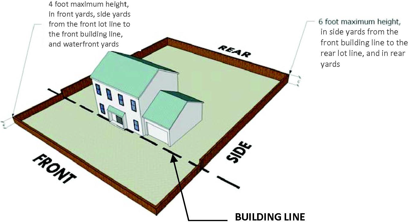
4.4.3 - Height.
A.
Fences and walls, other than those for courtyards per section 3.16 and for screening or security per section 4.4.4, are subject to the height limits below:
Table 4-8 Height Limits for Fences/Walls and Hedges
B.
Height limits apply within the yard regardless of physical connection of the fence or wall to the principal structure.
C.
The height of fences, walls and hedges is measured from the adjacent finished grade. Berms used in conjunction with fences or walls shall be considered as included in the height restriction for such structures. Where significant elevation differences exist between two adjacent properties, the height may be increased by the average difference in elevation between the two sides, measured from the finished grade up to five feet away on either side. The height may be similarly increased where significant elevation differences exist along a given property line. The additional height increase in both situations shall be limited to a maximum of two feet.
D.
Decorative appurtenant elements shall be allowed to exceed the maximum fence/wall height as follows:
1.
Column or post caps: up to an additional six inches. Caps may include masonry capitals, sculpture, finials, and the like.
2.
Caps on corner columns or posts and those supporting an entry gate to the property: up to an additional one-fourth of the maximum fence/wall height. Caps may include masonry capitals, sculpture, finials, and the like, as well as decorative lamps provided they do not create glare and shine onto adjacent properties or public rights-of-way.
3.
Entry gates to the property: up to an additional one-fourth of the maximum fence/wall height.
4.
Archways, arbors, and trellises physically attached to the fence/wall to create a pedestrian entry to the property from the street: up to a total maximum height of eight feet above the adjacent finished grade, and a maximum depth of five feet into the property from the property line.
E.
Chain-link fencing around tennis courts and other approved recreational amenities shall be allowed up to 12 feet in height.
(Ord. No. 2015-07, § 2(Exh. A), 11-19-2015; Ord. No. 2017-07, § 2, 5-18-2017; Ord. No. 2021-03, § 2(Exh. A), 2-18-21)
4.4.4 - Screening and security.
Additional height and materials may be allowed for fences and walls for specific purposes, as follows:
A.
For all multi-family and non-residential uses, opaque fences or walls shall be allowed up to eight feet in height to screen dumpsters, mechanical equipment used for heating, cooling, ventilation, refrigeration, utility service and monitoring, and other similar purposes. The eight-foot height allowance shall apply in the building area and all required yards, including waterfront yards, except within the visual clearance triangle on corner lots.
B.
For public uses, opaque fences or walls shall be allowed up to six feet in height within all required yards if necessary to secure property, except within the visual clearance triangle on corner lots. When public uses and parks and recreation facilities are adjoining single-family residences, the height of the fence for the public use or the single family may increase to eight feet on that side only to provide additional privacy for the single-family residences. In front yards of public facilities, fences over four feet in height shall be set back a minimum of five feet from the front property line.
C.
See section 4.10.3, Table 4-17 for required vegetative screening of vehicular use areas and between different land uses.
D.
Waivers. For public and institutional uses with unique security needs, the planning board shall consider requests to waive fence and wall limitations regarding maximum height and use of barbed wire, as provided below. Waivers may not authorize a fence or wall to exceed a maximum total height of ten feet.
1.
Initiation, submittal, and fees. Written applications for a waiver shall be submitted in accordance with section 6.3.3 and shall demonstrate compliance with the criteria established below.
2.
Public notice. Published, written, and posted notice is required pursuant to section 6.3.5.
3.
Criteria. The planning board shall only approve a waiver request if the applicant demonstrates that the requested waiver meets all the following criteria:
(a)
The requested waiver is necessary based on the unique security needs of the property and its historic or intended use, which are not shared by landowners in general;
(b)
The requested waiver is the minimum necessary to achieve the security needs for the intended use;
(c)
The requested waiver will not diminish property values and will not have a negative impact on adjacent properties;
(d)
The requested waiver will not alter or adversely impact the essential character of the surrounding neighborhood; and
(e)
The requested waiver is consistent with the comprehensive plan, other adopted plans, and the stated purpose of this section.
4.
Planning board public hearing and decision. The board shall hold a public hearing and approve, approve with conditions, or deny the application.
5.
Conditions. The planning board may impose any conditions on the waiver deemed necessary to further the purposes of this code, including mitigation of any perceived negative impacts or periodic verification that the unique needs of the property still exist. Violation of any conditions shall be treated as a violation of this code subject to enforcement as otherwise provided by the code, and may result in revocation of the waiver in addition to any other authorized penalties.
6.
Effective date and expiration. A waiver shall become effective upon written approval by the planning board. Waivers shall automatically expire if:
(a)
The fence or wall subject to the waiver is not constructed within 12 months from the date the waiver is approved;
(b)
The use for which the waiver was granted does not commence within 12 months from the date the waiver is approved;
(c)
If the property is abandoned for six consecutive months;
(d)
The use of the property changes such that the unique screening or security needs for which the waiver was granted no longer exist; or
(e)
The fence or wall subject to the waiver is expanded, enlarged, falls into disrepair, or is removed.
(Ord. No. 2015-07, § 2(Exh. A), 11-19-2015; Ord. No. 2017-07, § 2, 5-18-2017; Ord. No. 2021-03, § 2(Exh. A), 2-18-21)
4.4.5. - Maintenance.
A.
All fences, walls, gates, and appurtenant decorative elements shall be maintained in their original upright condition and in good repair, with no loose sections, such that they will not constitute a danger to pedestrians or users of the adjoining property or public right-of-way.
B.
Missing boards, pickets, posts, and other components shall be replaced in a timely manner with material of the same type and quality and in accordance with the applicable building codes.
(Ord. No. 2015-07, § 2(Exh. A), 11-19-2015; Ord. No. 2017-07, § 2, 5-18-2017)
4.6.1 - Block layout.
A.
The width of any block shall be sufficient to accommodate two tiers of lots, unless one tier of lots abuts an area of nonresidential development, an arterial street, or a utility right-of-way.
B.
Where land is subdivided into larger parcels than ordinarily expected for building lots, the parcels shall be arranged to allow for the opening of future streets and drainage, and logical further subdivision.
4.6.2 - Lot layout, design and development.
A.
The size, shape and orientation of lots shall be appropriate for the type of development and use contemplated.
B.
Every principal or accessory structure to be erected upon a lot shall meet all yard, lot coverage, floor area and building height requirements of its zoning district unless otherwise expressly permitted by these regulations.
C.
No lot or lots fronting on an existing street shall be subdivided to permit new structures that conflict with the orientation of the majority of existing structures.
D.
Lot dimensions shall comply with the applicable zoning district requirements (see article 2).
E.
Side lot lines shall be substantially at right angles or radial to street right-of-way lines.
F.
All lots fronting on a curve shall have a minimum width at the street line of 35 feet, and shall be platted to provide the required lot width at the building line.
G.
Properties adjacent to Atlantic Avenue or Peninsula Drive shall be subdivided, when practical, to provide driveway access to the resulting lots from interior streets.
4.6.3 - Lot classification.
A.
Lots are classified as:
1.
Corner lots,
2.
Interior lots,
3.
Through lots, and
4.
Atypical lots.
The following diagram illustrates these lot types.

B.
In the diagram, "A" designates corner lots. Corner lots are defined as lots located at the intersection of two or more streets. A lot abutting a curved street or streets is considered a corner lot if straight lines drawn from the front-most points of the side lot lines to the front-most point of the lot meet at an interior angle of less than 135 degrees (See lots marked "A(1)" in the diagram).
C.
"B" designates interior lots. Interior lots are defined as lots with only one frontage on a street.
D.
"C" designates through lots. Through lots are defined as lots other than corner lots with frontage on more than one street. Through lots may also be referred to as double-frontage lots.
E.
"D" designates atypical lots. Atypical lots are defined as lots within a subdivision where, as a result of subdivision design, the lots abut a street at one end and any of the following at the opposite end
1.
The Atlantic Ocean;
2.
A waterway 100 feet or more in width;
3.
A golf course fairway or green;
4.
An open space area which by itself, or when combined with other open space areas within the same subdivision comprises at least 15 percent of the total land area in a subdivision, and in which an undivided interest is conveyed with each lot.
4.6.4 - Number of uses and buildings.
A.
A lot shall not be occupied by more than one principal use or one principal structure, along with their accessory uses or structures, unless otherwise provided in the LUDC. Only one principal structure may be erected or constructed on a single lot unless otherwise provided in the LUDC.
B.
Two or more principal uses are permitted on a single lot in any MF-2, B-1 or B-2 district, if:
1.
The entire area on which the uses are to be established is under single ownership, and
2.
Each use meets the minimum requirements for off-street parking, loading and unloading facilities, and
3.
Each use meets the minimum lot and building requirements for the district in which the property is located.
C.
Subsection 4.6.4.A above does not apply to the PUD or PWD districts.
4.6.5 - Frontage.
All lots shall have frontage on an improved public or private street.
4.6.6 - Lot area.
A.
Definition. The upland surface area contained within the boundary lines of a lot. For the purposes of determining the maximum lot coverage, floor area ratio, and density for lots with waterfront yards, the mean high-water mark or ordinary high-water mark is substituted for lot boundary lines wherever those lines fall within the lot boundary lines. Lot area on residential properties with TIIF-deeded submerged lands includes the uplands and submerged area within the platted lot lines.
B.
A lot must include sufficient land area to meet:
1.
The minimum lot area prescribed for the applicable zoning district, and
2.
Zoning requirements for use, coverage, and area, yards, other open spaces, parking and other requirements of the LUDC.
C.
No lot existing on the effective date of these regulations shall be reduced in area and width below the minimum requirements of its zoning district, except lots made up of combinations of non-conforming lots (refer to section 7.3) or cluster subdivision lots (see definition, section 3.25).
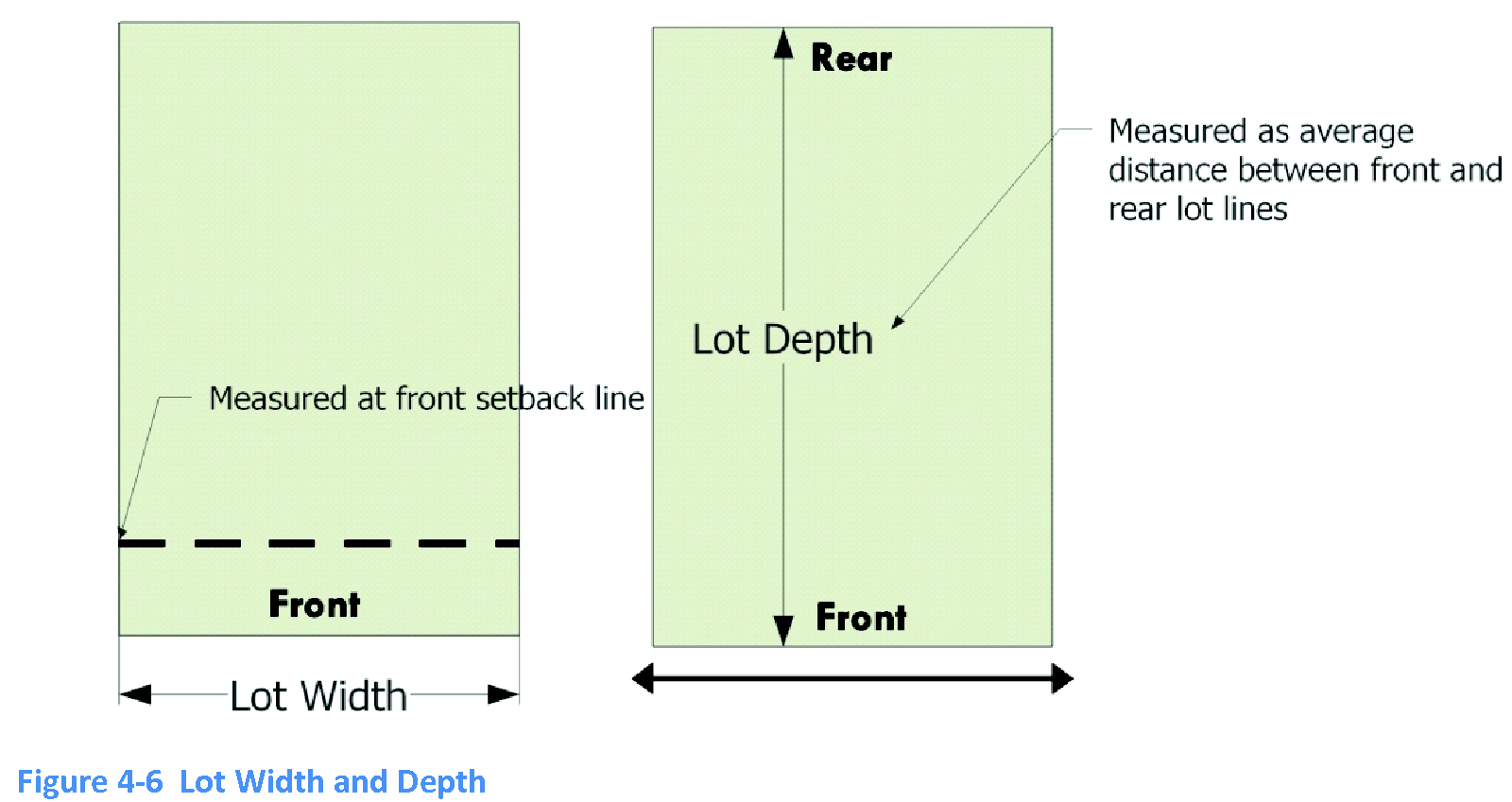
4.6.7 - Lot width.
A.
Definition. The horizontal distance between the side lot lines, measured along the front building setback line. For waterfront lots, the "waterfront lot width" is expressed in feet at the mean high water line. Unless otherwise provided, "lot width" includes "waterfront lot width."
B.
Lots shall have sufficient width to comply with the applicable zoning district requirements.
4.6.8 - Lot depth.
A.
Definition. The average horizontal distance between the front and rear lot lines, including submerged lot lines of residential properties with TIIF-deeded submerged lands. Otherwise, tor the purposes of determining the lot depth, the mean high-water mark or ordinary high-water mark is substituted for the rear lot boundary lines wherever those lines fall within the rear lot boundary lines.
B.
Lots shall have sufficient width to comply with the applicable zoning district requirements.
4.6.9. - Flag lots.
A.
Definition. A lot not meeting the minimum frontage requirements and where access to a street right-of-way is by a narrow, private driveway.
B.
Flag lots may only be approved for single-family homes in those zoning districts that allow single-family residences as permitted uses.
C.
Flag lots shall have a minimum frontage of 25 feet on a public street or private way constructed to current town standards.
D.
There shall be usable access provided from the street to the main body of any flag lot.
E.
No more than two flag lots may be created out of any one parcel being considered for a minor replat.
4.6.10 - Setback and yard requirements.
A.
General provisions.
1.
No part of any building may project into any required yard, except as otherwise permitted by the LUDC and section 3.2.4 and Table 3-1.
2.
No part of a yard, or other required open space for one structure shall be included as part of a yard or open space for any other structure.
B.
Setbacks, definition.
1.
A setback line defines the interior boundary of a required yard. Setbacks are measured perpendicular to and parallel with property or right-of-way lines.
2.
Where any building or structure is not built parallel to a property or right-of-way line, the setback distance is measured perpendicular from that part of the building or structure that is closest to the relevant property or right-of-way line. See Figure 4-7.

3.
On residential lots with submerged TIIF-deeded lands, waterfront yard setbacks shall be measured from the platted lot lines, whether or not those lines are submerged.
On all other waterfront properties, the waterfront yard setbacks shall be measured from the mean Setbacks high-water line or the town's natural bulkhead line, even if the mean high-water mark or natural bulkhead line falls within the lot lines. In these cases, for the purposes of determining maximum lot coverage, floor area ratio, and density for lots with waterfront yards, the mean high-water mark or natural bulkhead line shall be substituted for lot lines. On lots with seawalls the yard shall be measured from the seawall.

C.
Building area, definition. The area within and bounded by the building lines established by required yards and setbacks. See Figure 4-9.
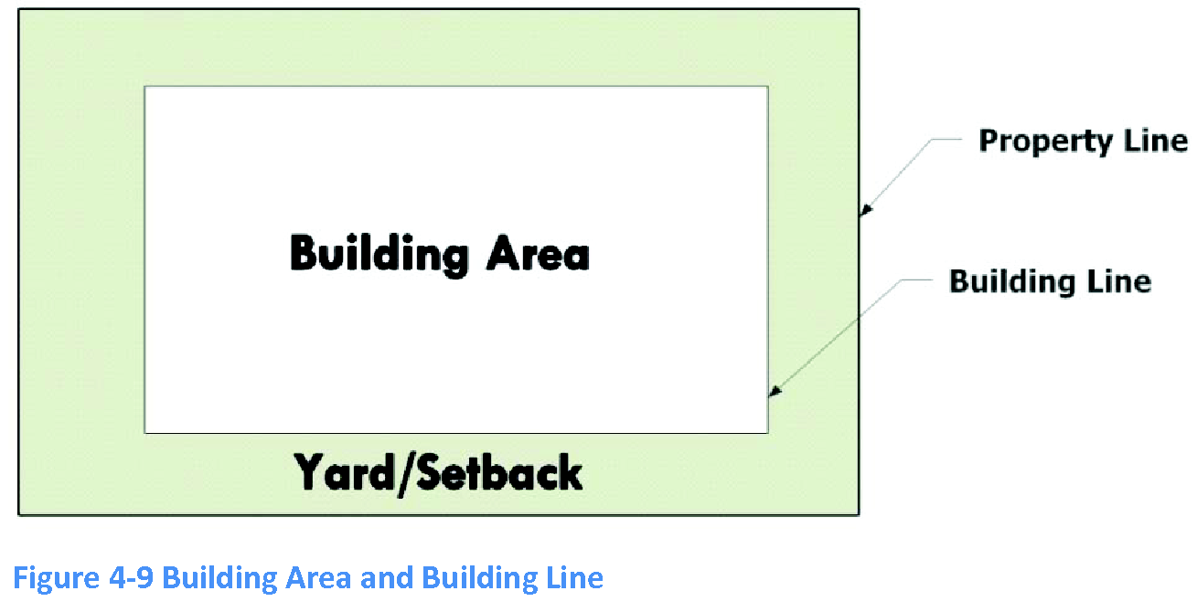
D.
Building line, definition. The line established by minimum yard requirements outside of which no principal structure may be erected. See Figure 4-9.
E.
Off-street parking spaces in yards. In all zoning districts, off-street parking spaces may be located in yards to the extent permitted by section 4.7.5 and in compliance with section 4.10.3.
4.6.11 - Lot coverage.
A.
Definition. That area of a lot from the ground up, which is occupied by principal and accessory buildings. Lot coverage applies only to buildings. It does not apply to structures or surfaces other than buildings. Except as provided below, lot coverage calculations for properties with submerged lands include only the upland lot area, substituting the mean high-water mark or ordinary high-water mark for lot boundary lines. However, lot coverage calculations for residential properties with TIIF-deeded submerged lands include the entire area within the lot boundary.
See also definitions for "TIIF-deeded submerged lands" and "Upland," article 9.
B.
Applicability.
1.
Lot coverage applies only to buildings. It does not apply to structures or surfaces other than buildings. Except as provided below, lot coverage calculations for properties with submerged lands include only the upland lot area, substituting the mean high-water mark or ordinary high-water mark for lot boundary lines.
2.
Lot coverage calculations for residential properties with TIIF-deeded submerged lands include the entire area within the lot boundary.
3.
Lot development must occur within the maximum lot coverage required by the applicable zoning district. That portion of a boathouse, dock, or other accessory structure that is allowed to build on submerged land, is not counted toward the maximum lot coverage.
4.6.12 - Building height.
A.
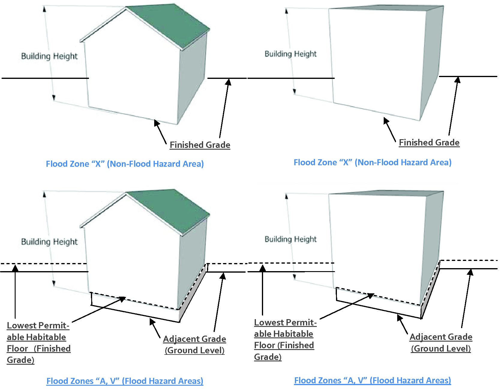
Building height is measured as the vertical distance in feet from any point of the finished grade abutting any point along the front of the structure, to the highest point of the structure. If the structure has a roof, height shall be measured to the highest point of the roof. For the purpose of this section, in areas designated as special flood hazards by the National Flood Insurance Program FIRM maps (Zones "A" and "V"), the lowest permit-able habitable floor shall serve as the finished grade for measuring the height of residential buildings.
Figure 4-10 Building Height
B.
For purposes of subsection A, the "highest point" of a roof or a structure includes mechanical equipment, spires, steeples, belfries, cupolas, and other architectural features. Florida Building Code items such as chimneys, guardrails, bulkheads, and penthouses used solely to enclose stairways, tanks, elevator machinery or shafts or ventilation or air conditioning apparatus are not included in determining building height. Items required by the Florida Building Code shall be limited to the minimum height necessary. Items or structural elements required by other state laws or the Federal Telecommunications Act are not included in determining building height.
C.
Buildings shall not exceed the maximum height established by the applicable zoning district.
(Ord. No. 2013-06, § 2, 4-18-2013)
4.6.13 - Floor area and floor area ratio.
A.
Floor area.
1.
Definition. The gross floor area of any building. The "gross floor area" means the sum of the gross horizontal areas of the several floors of a principal structure and all related accessory structures.
2.
Measurement. In measuring the floor area, all dimensions shall be taken from the outside face of the framing or other primary wall members. Veneer facades up to eight inches in thickness are excluded from the calculation of floor area. However, that portion of a facade that exceeds eight inches is included.
3.
Exclusions.
a.
The following areas are excluded from the calculation of floor area:
• Attic areas with headroom of less than seven feet or constructed such that they do not meet the minimum requirements for load-bearing use as living or storage space;
• Unenclosed stairs or fire escape;
• Porches, patios, breezeways, sun porches, lanais, decks, or other similar structural additions that are unenclosed or are enclosed with screening, whether or not covered by a roof or architectural projection from a building. These additions are exempt from the floor area calculations for up to 15 percent of the maximum floor area allowed. Any areas in excess of the 15 percent allowance are calculated as part of the floor area;
• Fireplaces, elevators, stairs, and similar features;
• Exterior swimming pools, whether screened-in or not; and
• Decks with a floor height not exceeding 30 inches above the finished grade, whether screened-in or not.
b.
For non-residential uses, accessory structures up to 400 square feet of enclosed area are excluded that are used to store materials used on-site (such as acetone paint or similar materials).
B.
Floor area ratio (FAR), definition and measurement. A ratio determined by dividing the gross floor area of all buildings on a non-residential lot by the total area of that lot.
(Ord. No. 2013-08, § 3, 6-20-2013)
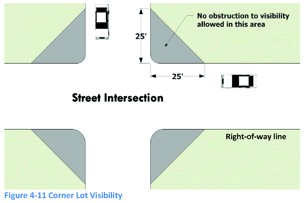
4.6.14 - Obstruction to visibility on corner lots.
A.
On any corner lot, no structure or shrubbery shall obstruct vision at the street intersection. Structures and shrubbery shall be kept clear within a visual clearance triangle extending 25 feet back from the corner of the intersecting right-of-way lines, between three and ten feet in height above the centerline grades of adjacent streets. If the right-of-way lines are not discernible, the triangle may be measured from the curb, or the edge of street pavement if no curb is present. In such cases, the director may require the size of the visual clearance triangle to be increased, up to a maximum of 35 feet.
B.
The director, upon recommendation of the chief of police, may relax restrictions of this section or impose additional restrictions upon the height or location of structures and shrubbery that impair visibility at the intersection.
4.6.15 - Density, dwelling unit.
A.
Definition. The total number of dwelling units divided by the overall property size, in acres of usable land. See also definitions of "TIIF-deeded submerged land" and "Usable land," article 9.
B.
Calculation.
1.
Residential density is calculated using acres of usable land, which also includes TIIF-deeded submerged lands.
2.
For purposes of calculating density, a fractional part of an acre will permit that fractional part of the number of dwellings allowed for a full acre. Calculations resulting in a fractional part of a dwelling are rounded up to the next whole number of dwellings whenever the fractional part of a dwelling is one-half or greater.
C.
Generally. The number of dwelling units on a lot shall not exceed the maximum density established by the applicable zoning district.
4.7.1 - Purpose and applicability.
A.
This section ensures that all developments provide for adequate and safe storage and movement of vehicles in a manner consistent with community standards and good engineering and site design principles.
B.
This section applies to the design, construction, amount, and vehicle type of off-street parking and loading areas.
C.
The requirements herein shall apply as follows:
1.
To new site development;
2.
To expansion of an existing use or change to a new use that triggers the need for additional parking; and
3.
Redesign or reconfiguration of an existing parking facility.
D.
Parking for lawfully established, pre-existing developments is pursuant to Section 4.7.8.D.
(Ord. No. 2015-06, § 2(Exh. A), 10-15-2015)
4.7.2 - Generally.
A.
All areas shall be designed for the safety and convenient access of pedestrians and vehicles.
B.
Off-street parking and loading areas shall be maintained in a smooth, well-graded condition.
C.
Buildings, parking and loading areas, landscaping and open spaces shall be designed so that pedestrians moving from parking areas to buildings and between buildings are not unreasonably exposed to vehicular traffic.
D.
Each off-street parking and loading space shall open directly onto an aisle or driveway that, except for single-family and two-family residences, is not a public street.
E.
Aisles and driveways shall not be used for parking vehicles, except that the driveway of a single-family or two-family residence or townhouse shall be counted as a parking space for the dwelling unit.
F.
The design shall be based on a definite and logical system of drive lanes to serve the parking and loading spaces. A physical separation or barrier, such as a vertical curb or landscape island, may be required to separate parking spaces from travel lanes.
G.
Parking spaces for all uses, except single-family and two-family residences and townhouse units with attached garages, shall be designed to permit entry and exit without moving any other motor vehicles.
H.
No parking space shall be located so as to block access by emergency vehicles.
I.
No designated off-street parking or loading space or drive shall be located within three feet of any building or structure which such vehicular facility is intended to serve.
J.
Dead-end aisles with adjoining parking spaces shall have an extension of the aisle a minimum of five feet beyond the last space to provide for vehicular maneuvering.
K.
Any parking area to be used by the general public shall provide ADA-compliant, accessible parking spaces, the number, design, and location of which shall be consistent with the requirements of Code of Ordinances section 74-36, the Ponce Inlet Standard Construction Details, and Florida Statutes. Such parking spaces may be counted toward the minimum number of spaces required by this section. All ADA-compliant, accessible parking spaces shall be paved.
(Ord. No. 2015-06, § 2(Exh. A), 10-15-2015)
4.7.3 - Surfacing of off-street parking and loading facilities.
A.
Every off-street parking and loading area shall be surfaced with pavement, brick, paver block, asphalt, or concrete or with a pervious surface such as porous asphalt or concrete, turf block, shell or gravel pursuant to [subsection] 4.7.3.B.
B.
Pervious surfaces may be utilized as follows:
1.
An applicant shall provide a plan for maintaining the pervious surface with the application for development approval to demonstrate the continued function of the pervious pavement materials.
2.
The Town shall allow pervious parking surfaces to be factored into the stormwater runoff and storage calculations for the property, under section 4.9.
3.
Pervious surface materials shall not be allowed if, in the professional opinion of the town engineer, their use will not reduce the quantity or improve the quality of stormwater runoff, or will create on-going erosion and maintenance problems.
4.
The town may require greater setbacks, different pavement materials, or other plan modifications if necessary to address site-specific conditions and potential erosion and maintenance concerns.
5.
The portion of the driveway and driveway apron in the right-of-way shall be designed pursuant to section 4.2.5 of this code.
6.
Surfaces composed of porous asphalt, porous concrete, or turf block shall be marked (striped) the same as those composed of non-pervious surfaces.
7.
Surfaces composed of loose material such as shell or gravel shall meet the following additional standards:
a.
Parking and loading areas shall be defined with a visual and functional border that restricts wash-out and migration of surfacing materials, especially on slopes and stormwater runoff swales. Borders may include healthy landscape plants, landscape timbers, pavers, brick or similar materials.
b.
Individual parking spaces shall be delineated, such as through the use of railroad ties or wheel stops.
c.
Pervious surfaces composed of aggregate material such as crushed stone and gravel shall not exceed a maximum slope of 12%, unless designed by a licensed civil engineer to meet the performance standards of this section.
(Ord. No. 2015-06, § 2(Exh. A), 10-15-2015)
4.7.4 - Lighting.
Parking lots of 20 spaces or more that are to be used after dark shall be illuminated for safety. Parking lot lighting may be pole-mounted or ground-mounted. Lighting shall be directed and/or shielded so as not to shine directly upon any adjacent residence or street and not produce excessive glare. Parking lot lighting measured at the property line shall not exceed 0.5 footcandles.
(Ord. No. 2015-06, § 2(Exh. A), 10-15-2015)
4.7.5 - Location.
A.
Except as provided in subsection 4.7.5.C below, off-street parking and loading areas shall be located on the same lot they are intended to serve.
B.
Off-street parking and loading areas shall be located at least the distance prescribed in the following table from any lot lines.
Table 4-9 Parking and Loading Area Minimum Setbacks
C.
For non-residential uses, if the required off-street parking spaces cannot reasonably be provided, in whole or in part, on the same lot on which the principal building or use is located, the off-street parking area may be located on another lot if:
1.
The property is properly zoned for the permitted principal use it is intended to serve;
2.
The off-site lot or parcel is located within 300 feet of the premises to be served;
3.
Both the owner of the premises to be served by the off-site parking and the owner of the property on which the off-site parking will be located provide a written agreement or deed restriction, in a form acceptable to the town attorney and subject to approval by the town council, ensuring the continued availability of the off-site parking facilities for the use they are intended to serve so long as the parking is required;
4.
The agreement or deed restriction shall be recorded in the public records of Volusia County at said owners' expense, shall run with the land, and shall remain in effect until the parking is no longer required.
(Ord. No. 2015-06, § 2(Exh. A), 10-15-2015)
4.7.6 - Plan requirement.
An application for a building permit shall be accompanied by an off-street parking and/or loading space plan. The plan shall accurately illustrate the number, location and dimensions of parking spaces, access aisles, driveways, vehicle turnarounds, or backup areas, areas designated for trash collection, off-street loading spaces, if required, and any required landscaped buffer areas. Such plans shall also be submitted in conjunction with parking lot resurfacing and/or restriping if the number or configuration of spaces is proposed to change.
(Ord. No. 2015-06, § 2(Exh. A), 10-15-2015)
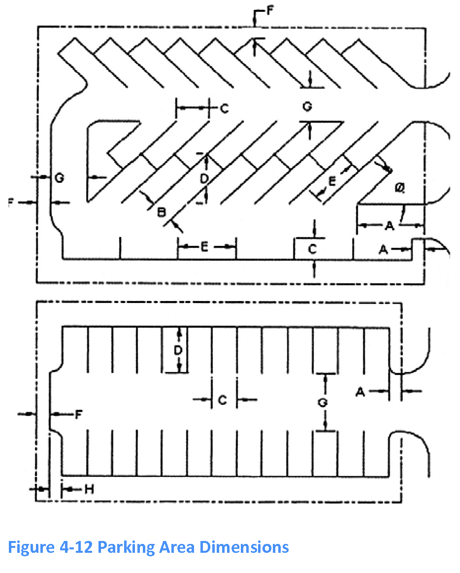
4.7.7 - Dimensional requirements for off-street parking areas.
A.
Off-street parking areas shall be designed to meet the following angles, dimensions and requirements. Dimensions for parking at any of these angles are:
Table 4-10 Parking Space Dimensional Requirements
* Letters refer to this figure:
B.
Design standards adjacent to landscape areas.
1.
Continuous non-mountable six-inch high concrete curbing shall be installed adjacent to all landscape areas to protect landscape planters required by subsection 4.10.3.C.2. Curbing shall be similar or equal to Florida DOT type "D" or "F" curbs as shown on DOT Standard Index No. 300. Curbs extruded onto the surface of the pavement are not permitted.
2.
The top of the curbing shall run parallel to the adjacent pavement. The face of the curb shall be sloped to be two inches narrower at the top than at the base. All surfaces of the curbing shall be smooth and all corners rounded to prevent chipping. Sharp corners shall be avoided by using a minimum three-foot transition radius between any two sides.
3.
If the building official determines that the curbs are insufficient to prevent vehicular encroachment into landscape areas, then bollards or similar devices that prohibit encroachment may be required. These fixtures shall be architecturally consistent with other site fixtures and structures.
4.
Alternative permanent barriers may be used in parking lots surfaced with crushed shell provided the barrier is sufficient to prevent vehicle overhang encroachment and can separate any loose material in the parking area from the landscape area.
5.
At the head of parking stalls, curbing or precast concrete wheel stops of standard size shall be placed and secured to prevent vehicular encroachment into the required landscape area.
(Ord. No. 2014-04, § 2(Exh. A), 7-17-2014; Ord. No. 2015-06, § 2(Exh. A), 10-15-2015)
4.7.8 - Minimum number of off-street parking spaces.
A.
Generally.
1.
Where required by the LUDC, every use or structure shall have an adequate number of off-street parking and loading spaces for use of occupants, employees, customers, visitors, patrons or suppliers. Table 4-11 establishes minimum required number of off-street parking spaces for a use.
2.
The number of spaces required for any use not specifically mentioned is the same as for the use most similar to the requested use.
3.
No part of the off-street parking or loading spaces for one structure shall be included as part of the off-street parking or loading space requirements for any other structure, except as allowed under [subsection] 4.7.8.B.
4.
Fractional spaces are rounded to the closest number.
5.
For assembly places where occupants sit on benches, bleachers, or pews without dividing arms, each 18 linear inches of the seating structure is counted as one seat.
B.
Shared parking for multiuse developments.
1.
For any two or more uses with peak parking demand occurring at different times, the town council may allow a limited number of parking spaces required for one use to be used as required parking for another use, if:
a.
The shared parking spaces and the uses they are intended to serve are under the same ownership.
b.
Reserved parking spaces are not shared.
c.
The shared parking spaces are located so as to be visible and conveniently related to all uses they are intended to serve.
2.
A subsequent change in use requires a new use and occupancy permit and proof that sufficient parking will be available.
3.
The number of parking spaces required for a multiuse development is computed as follows:
a.
Multiply the minimum number of parking spaces normally required for each land use by the corresponding percentage as shown in Table 4-12 for each of the five time periods shown;
b.
Then add the number of parking spaces required for each use in each time period (column); and
c.
The highest column total is the applicable parking requirement.
C.
Parking space reduction. The town council may approve requests to allow fewer parking spaces than the minimum number required under the circumstances below. All such requests shall be accompanied by supporting documentation, including professionally recognized standards or professionally prepared studies.
1.
If the national average parking demand for the use, as determined by the Institute of Transportation Engineers or other professional source, is less than the minimum requirement of this code.
2.
If the anticipated parking demand for the use in its specific location will be less than the minimum required.
3.
If the use is located within 500 feet of a transit stop and a portion of the demand is expected to be met by transit.
4.
If the use operates its own shuttle or bus service to bring guests to the establishment. In such cases, the establishment owner shall enter into a written agreement with the town providing:
a.
That the required number of spaces shall be constructed should the shuttle or bus service cease operation;
b.
The owner agrees to bear the expense of recording the agreement and further agrees that the agreement shall bind his or her heirs, successors and assigns; and
c.
The owner shall be released from the agreement in the event duly permitted alternative parking arrangements are established and approved by the town council or the parking arrangements established by the agreement are no longer required.
D.
Application of parking space requirements to pre-existing land uses and developments.
1.
Any land use or development that had been lawfully established with fewer parking spaces than required by this section is allowed to continue as if the required number of parking spaces exists.
2.
However, no new use or development is permitted, and no substitution of a new land use for any existing land use is permitted, unless the total number of parking spaces is provided as required by this section for all existing and proposed land uses and development on the entire site over which the applicant has control.
3.
For purposes of this section, land uses or developments that had been lawfully established with fewer parking spaces than required by this section include, but are not limited to, land uses and developments that were approved in accordance with any previously applicable requirement for fewer parking spaces.
E.
Motorcycle parking. In development sites requiring more than 20 automobile parking spaces, five percent of the required automobile parking spaces may be converted to motorcycle parking. Motorcycle spaces shall be a minimum of four feet wide and ten feet long. All motorcycle parking shall be clearly identified through signage or pavement marking as reserved for motorcycles only.
F.
Bicycle parking.
1.
In addition to the minimum number of vehicular parking spaces required in Table 4-11 all new development except for single-family and two-family residential shall also provide one off-street bicycle parking space for every ten required motorized vehicle parking spaces. Bicycle parking for developments and uses established prior to the effective date of this requirement shall be required pursuant to subsection 4.7.8.D above.
2.
Bicycle racks or other acceptable bicycle parking devices shall:
a.
Be solidly anchored and designed to secure the bicycle from theft and damage.
b.
Be located in safe, well-lighted areas, with direct, convenient access to both the principal building entrance and the right-of-way or bikepath.
3.
Bicycle parking deferral. The town may authorize deferral of required bicycle parking spaces when the nature of the use, information supplied by the developer or previous experience for similar uses in the town suggests that the bicycle parking is not necessary. The developer shall note on the development plan the number and location of spaces to be deferred, and an obligation to provide the bicycle parking when its need has been determined by the town. Deferred bicycle parking spaces shall comply with requirements of this code at the time of installation.
Table 4-11 Minimum Required Parking Spaces
Table 4-12 Mixed Use Development Parking Requirements Worksheet
(Ord. No. 2015-06, § 2(Exh. A), 10-15-2015)
4.7.9 - Required off-street loading spaces.
A.
Purpose. This section provides for sufficient off-street loading areas to ensure that the free movement of vehicles and pedestrians over a sidewalk, street, alley, driveway or traffic aisle is not impaired.
B.
Applicability. This section applies to:
1.
Every institutional, commercial or industrial building or similar use that utilizes delivery vehicles; and
2.
Every commercial boat operation, including charter boat and "head boat" operations, with a capacity of 25 persons or more on any one boat.
C.
Standards.
1.
Every use shall provide sufficient space for loading and unloading operations consistent with the purposes listed for this section.
2.
Every off-street loading space shall have access to a public street, and shall have adequate room for maneuvering, ingress and egress.
3.
Loading spaces shall have the following minimum dimensions:
Table 4-13 Off-Street Loading Space Dimensions
a.
The town may require the length of the loading space to be increased up to 55 feet if larger delivery vehicles are anticipated. Developers may install spaces that are larger than the standard, but the number of spaces shall not be reduced on that account.
b.
The town may allow the length of the loading space to be reduced to 20 feet if smaller vehicles are anticipated.
(Ord. No. 2015-06, § 2(Exh. A), 10-15-2015)
4.7.10 - Additional parking requirements for all uses in the B-2 district.
A.
Collective off-street parking provisions. Nothing in this LUDC shall be construed to prevent the collective provision of shared, off-site, off-street parking facilities for two or more buildings or uses, provided that the total of such off-street parking spaces supplied collectively shall not be less than the sum of the requirements for the various uses computed separately; and further provided that the 300-foot maximum distance between parking facilities and principal structures or uses served shall apply to each building or use participating in the collective provisions for parking.
B.
Reserved.
(Ord. No. 2015-06, § 2(Exh. A), 10-15-2015)
4.7.11 - Parking and storage of vehicles or watercraft in residential districts.
A.
Trucks and large vehicles. On residentially zoned property, overnight parking of trucks and large vehicles shall be limited to the following:
1.
FHWA Class 1 (manufacturer gross vehicle weight rating of 6,000 lbs or less).
2.
FHWA Class 2 (manufacturer gross vehicle weight rating of 6,001—10,000 lbs),
3.
FHWA Class 3 (manufacturer gross vehicle weight rating of 10,001—14,000 lbs) van conversions per F.S. 320.01(1)(b)6 and pickup trucks for personal use only.
Overnight parking of larger vehicles such as delivery trucks, semis, commercial buses, beach concession wagons, or similar vehicles shall be prohibited.
B.
Recreational vehicles, watercraft, and trailers. Recreational vehicles as defined in this code, watercraft, and trailers that are parked in any R-1 through R-3 district or in any other zoning district on a premise on which the principal use is a single-family dwelling, shall meet the following standards:
1.
Principal use required. No recreational vehicle, watercraft or trailer shall be parked or stored except on a developed lot or parcel where a single-family principal structure exists.
2.
Temporary parking. Recreational vehicles, watercraft, and/or trailers may be parked in the driveway for a maximum time period of 72 consecutive hours per consecutive seven-day period. Dead storage in the abutting public right-of-way shall not exceed 24 hours per Code of Ordinances section 74-35.
3.
Long-term parking and storage. Parking and storage on the premises other than for temporary purposes per paragraph B.2 above shall be allowed only as follows:
a.
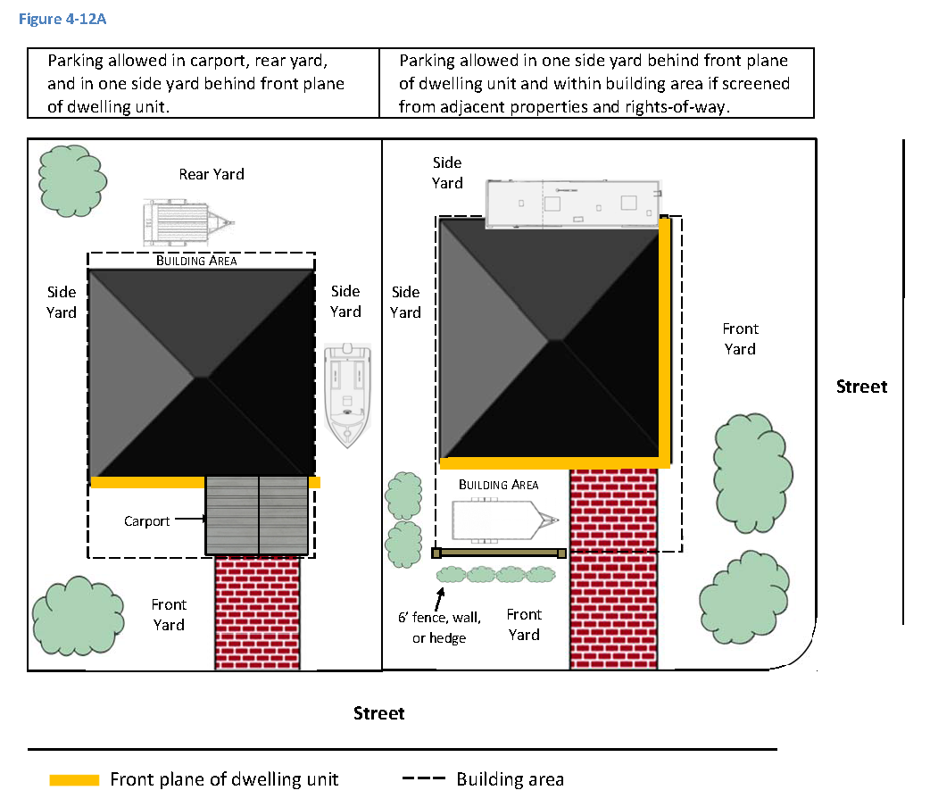
Located under a carport, within an enclosed garage or building, within the rear yard, or within one side yard located behind the portion of the principal structure closest to the street (front plane of the dwelling unit), unless subparagraph b. applies;
b.
Parked within the building area outside of all required yards, subject to screening requirements per paragraph B.4 below;
c.
Carports used for purposes of this code shall meet applicable setback requirements and must be permanent permitted structures pursuant to the Florida Building Code;
d.
No recreational vehicle, watercraft, and/or trailer shall be parked or stored in manner that extends onto the abutting public right-of-way or obstructs any required emergency access to or from the dwelling.
4.
Screening. Recreational vehicles, watercraft, and/or trailers parked in the building area shall be screened from adjacent properties and rights-of-way as follows:
a.
Screening shall consist of a minimum six-foot tall opaque fence, wall, or hedge. Screening may also include gates, doors, trees, existing natural vegetation, or a combination of such items provided the minimum height is met. Fabric tarpaulins or vehicle covers, or other similar non-permanent materials shall not count as screening for this purpose.
b.
Screening fences and walls located within the building area may exceed six feet in height only in compliance with courtyard standards in section 3.16. Fences and walls within required yards shall comply with the height limits in section 4.4.
c.
Hedges and other plant material shall be selected, located, and maintained to provide a visual barrier that is no less than 75 percent opaque within 180 days from the time of planting.
d.
All recreational vehicles, watercraft, and trailers that are parked in the building area of the property and are not screened from abutting properties and rights-of-way pursuant to this section as of January 23, 2020, shall be deemed legal nonconforming uses and shall be grandfathered from compliance. Legal nonconforming status shall only apply to the owner of the real property on which the recreational vehicle, watercraft, or trailer is parked as of that date.
5.
Maintenance and operational standards. Recreational vehicles, watercraft, and trailers parked outside of a fully enclosed structure shall:
a.
Have a current, valid license plate and/or decal;
b.
Be owned by an occupant of the property on which it is parked or stored;
c.
Where visible from the street, be placed in a reasonably neat and orderly manner, with the ground beneath kept free from debris and excessive weed growth;
d.
Be maintained in an operable and moveable condition and ready for highway use, with mounted and inflated tires, attached to the site only by quick-disconnect utilities and security devices, and free of permanent attachments such as additions, rooms, stairs, decks, and porches; and
e.
Have wastewater line caps secured at all times to preclude any leakage onto a lot or street.
6.
Usage. Recreational vehicles shall not be used for living, sleeping, or housekeeping purposes when parked or stored on a residential lot, as consistent with Code of Ordinances section 42-4. However, the town council, through an emergency declaration, may allow recreational vehicles to be used as temporary shelters on the subject property following a terrorist act, accidental fire or natural disaster. The duration of such temporary use shall be at the sole discretion of the town council. In such cases, the recreational vehicle shall be parked in compliance with the provisions of this section to the greatest extent possible; however, in no case shall the recreational vehicle be parked in the abutting right-of-way except as allowed per Code of Ordinances Chapter 74, Art. II, Div. 1.
7.
Hours of engine operation. Operation of recreational vehicle engines or associated equipment engines for maintenance purposes shall not occur between the hours of 9:00 p.m. and 7:00 a.m.
C.
Sale of vehicles, watercraft, and trailers in residential districts prohibited. Parking and display of any vehicle, watercraft, or trailer "for sale" in the front yard or in the abutting public right-of-way as per Code of Ordinances Section 74-35, is prohibited. Such vehicles, watercraft, or trailers are presumed to be offered for sale if:
1.
A "for sale" sign is displayed on or near the vehicle, watercraft, or trailer.
2.
The vehicle, watercraft, or trailer is parked in a location other than the driveway in a manner intended to attract the view of passersby.
(Ord. No. 2015-06, § 2(Exh. A), 10-15-2015; Ord. No. 2020-04, § 2(Exh. A), 1-23-2020)
4.8.1 - Purpose.
This section protects environmentally sensitive lands and cultural resources, while also protecting the rights of property owners.
4.8.2 - Environmental standards.
These environmental standards apply to all classifications:
A.
Air pollution. There shall be no emission of fumes, odors, vapors, gases, chemicals, smoke, dust, dirt, fly ash, or any particulate matter in violation of applicable state standards.
B.
Water pollution. There shall be no discharge of liquid or solid wastes into any public or private sewage disposal system, or into or on the ground, or into any waterway, water body or drainage canal, nor any accumulation of any liquid or solid wastes in violation of applicable state standards.
4.8.3 - Wetlands.
A.
Applicability.
1.
This section applies to all proposed development that is not exempted below.
2.
If the proposed project requires multiple permits from the federal, state, or regional agencies, a town jurisdictional determination shall not be required.
3.
This section does not apply to:
a.
Non-mechanical clearing of wetland or buffer vegetation from an area of 500 square feet or less, for access, if the vegetation is removed from the wetland and disposed of on a suitable upland site;
b.
Minor maintenance or emergency repair to existing structures or improved areas;
c.
Clearing and construction of walking trails having no structural components or fill and four feet wide or less;
d.
Overhead utility crossings (associated access roads are subject to this section);
e.
Maintenance, together with incidental dredge and fill activities in ditches, retention and detention areas, public road and other rights-of-way, and other related drainage systems;
f.
Bona fide mosquito control activities of the Volusia County Mosquito Control Department;
g.
Development within wetlands one-half acre or smaller (however, if the entire wetland exceeds this threshold for exemption whether on one or more lots, then the entire wetland is regulated as otherwise provided in this section);
h.
Development within artificial wetlands which are created as part of a manmade treatment system;
i.
Development where a federal, state, regional, or local government completed dredge and fill or wetland application was tendered to the government on or before the adoption of this section.
B.
Permit requirements.
1.
Applicability of wetland alteration permit.
a.
No person shall engage in any activity which will remove, fill, drain, dredge, clear, destroy or alter any wetland or wetland buffer on any lot without obtaining a wetland alteration permit in accordance with this section. A wetland alteration permit may be issued concurrent or in conjunction with other land development permits.
b.
Construction of a single-family dwelling on upland which does not alter by removing, filling, draining, dredging, clearing or destroying any wetland or wetland buffer does not require a wetland alteration permit.
2.
Pre-application. An applicant is encouraged to arrange a pre-application conference with the director to discuss the proposed wetlands alteration and the scientific method utilized to evaluate and justify any wetlands alteration prior to submitting a formal application to the director.
3.
Application.
a.
A wetlands alteration permit application is filed with the director.
b.
The director shall determine the completeness of the application within five days of filing. The director will return an incomplete application to the applicant. If the application is determined to be complete, the director shall consider the application received.
c.
Upon receipt, the director will review the application and conduct a preliminary site inspection.
d.
The director shall approve an application that meets all of the requirements of the LUDC within ten working days of receipt. Upon approval, the director shall return the application to the applicant with approval noted by the director.
e.
If the director denies the application, the application shall be returned to the applicant with the reasons for denial noted, within ten working days of receipt.
f.
If the director determines that the proposed activity fails to meet the minimum requirements of this article, or if additional information is required, the director will request additional information. The director will provide this request within ten working days after the preliminary site inspection. The applicant may modify the application and/or mitigation plans to prevent or limit the adverse impacts to the wetland or buffer, or file an appeal.
g.
If the applicant fails to make the necessary modifications or provide additional information within 60 days, then the director shall deny the permit.
h.
The director shall approve the permit within ten working days after receiving the required modifications or additional information, unless the modifications fail to meet the requirements of this section.
i.
The director shall notify the applicant immediately after the director approves or denies the application and issues the permit.
4.8.4 - Review criteria.
In determining whether the development complies with this section, the director shall consider, but is not limited to, the following criteria:
A.
The ability of the wetland to receive, store and discharge surface water runoff so as to contribute to hydrological stability and control of flooding and erosion;
B.
The ability of the wetland to recharge the groundwater as demonstrated by reliable available information;
C.
The ability of the wetland to provide filtration and nutrient assimilation from surface water runoff;
D.
The ability of the wetland to provide habitat and significant ecological function in the life cycle for fish, wildlife, or other forms of animal or plant life;
E.
The ability of the wetland to function as an integral part of any waters, water body, or watercourse;
F.
The cumulative impacts of the proposed development on the wetland system in combination with other developments which have been or shall be proposed in the same drainage basin;
G.
The technical feasibility of any proposed wetland mitigation plans and the likelihood of their success in restoring or replacing the environmental benefit altered by the development;
H.
The capacity of the existing wetland to provide environmental benefits because of factors such as maturity, size, degree of prior alteration, physical relationship to other water systems, and adjacent land uses;
I.
The degree or magnitude of the impact of the proposed alteration on the wetland and how the impact will be minimized through mitigation measures, either off-site or on-site, or both, and recommendations concerning the appropriate location of said mitigation;
J.
Whether, and the extent to which a proposed project must be located within a wetland or water body in order to perform the project's basic functions;
K.
Whether the wetlands impacted by the proposed activity are protected or used in a manner which does not adversely impact their beneficial functions.
4.8.5 - Issuance of permits—Conditions.
A.
If the application meets the requirements of this section, the director shall issue the permit and may attach appropriate conditions to the permit in order to comply with the standards of section 4.8.4. The director may deny the permit if it does not meet the standards, stating the reasons for that decision.
B.
The director may approve a wetlands alteration permit, which shall incorporate the general and specific conditions which were made part of the permit from federal, state, or regional agencies. However, before the issuance of the wetlands alteration permit, the federal, state, or regional permit application when available shall be submitted to the director. Concurrent applications to the local government and any federal, state, or regional agency are encouraged. However, the director is not prevented from approving additional conditions to the permit in order to comply with the standards of section 4.8.4.
4.8.6 - Buffer requirements.
A.
A buffer of at least 25 feet in width shall be established adjacent to and surrounding all wetlands.
Wetland buffers greater than 25 feet in width may be required if the upland activity adversely impacts the wetlands beneficial functions. The buffer may coincide with the setback on a lot under article 2 (Zoning Districts).
B.
Development activities or construction which do not have a significant adverse effect on the natural function of the buffer are allowed within the buffer. Proposed activities within the buffer may be permitted in accordance with this section. The activities or construction which may be permitted include, but are not limited to, pruning, planting of suitable native vegetation, removal of exotic and nuisance pioneer plant species, and the creation and maintenance of walking trails.
4.8.7 - Mitigation.
A.
Mitigation requirements. It is presumed that development activity will have an adverse effect upon wetlands, and that permit conditions are inadequate to avoid potential adverse environmental effects. If the applicant fails to overcome this presumption then mitigation is required. The purpose of mitigation is to offset unavoidable environmental impacts. Mitigation plans should consider the function of existing natural resources and provide comparable functions after mitigation is completed. Mitigation plans should maximize the preservation of existing natural resources.
B.
Mitigation priorities. The mitigation plans shall consider the following methods, in order of priority in which they should be used:
1.
Avoiding the impact altogether by not taking a certain action or parts of an action;
2.
Minimizing impacts by limiting the degree or magnitude of the action or its implementation;
3.
Rectifying the impact by repairing, rehabilitating, or restoring the affected environment;
4.
Reducing or eliminating the impact over time by preservation and maintenance operations during the life of the action;
5.
Compensating for the impact by replacing or providing substitute resources or environments through creation of new wetlands, enhancement of existing wetlands or reestablishment of wetlands which are no longer functioning due to significant attention in the past.
C.
Mitigation plan contents. Where all or part of a wetland is destroyed or substantially altered by development, a proposed mitigation plan shall include at least:
1.
A description of the wetland and buffer to be created or restored, which includes but is not limited to the type and functions of the wetland, the proposed mitigation ratios, species present or to be planted, plant density, anticipated source of plants, soils, and hydrologic regime;
2.
A plan for monitoring the success of a created or restored wetland;
3.
A detailed written estimate of the cost of the mitigation. The detailed estimate should include costs associated with earthmoving, planting, consultant fees, and monitoring;
4.
A detailed plan describing the monitoring and methods of control and maintenance of exotic or nuisance vegetation;
5.
Monitoring and replacement to assure a survival rate of 80 percent wetland vegetation for a minimum of three years;
6.
An upland habitat as an adjacent buffer on mitigated sites, as provided in section 4.8.6.
D.
Mitigation requirements.
1.
An acceptable mitigation plan shall be reasonably and technically feasible.
2.
Mitigation through restoration of other degraded wetlands is preferred over wetland creation.
3.
Mitigation should take place on-site or in close proximity to the site, or in areas so designated as provided in subsection 4.8.7.B.
4.
An applicant who carries out a compensatory mitigation plan shall grant a conservation easement on the newly created or restored wetland and buffer to protect it from future development. A legal mechanism other than a conservation easement may be deemed appropriate on a case-by-case basis to carry out the purposes of the subsection.
5.
A mitigation plan approved by a federal, state, or regional agency is presumed to be acceptable to the director. However, if no such mitigation plan is required by the approved permit from the federal, state, or regional agency, then the director may require a mitigation plan in compliance with this section.
6.
Mitigation should not contribute to the production of mosquitoes by creating mosquito larval habitat or by eliminating habitat for predatory fish.
E.
Mitigation ratios.
1.
In determining the replacement acreage ratios for restored or created wetlands, the director shall consider, but is not limited to, the following criteria:
a.
The length of time that can be expected to elapse before the functions of the impacted wetlands functions have been restored or offset.
b.
Any special designation or classification of the water body, including but not limited to Outstanding Florida Waters, Aquatic Preserves, or Class II.
c.
The type of wetland to be created and the likelihood of successfully creating that type of wetland.
d.
Whether or not the affected wetland is functioning as natural, healthy wetland of that type.
e.
Whether the wetland is unique for that watershed.
f.
The presence or absence of exotic or nuisance plants within the wetland and adverse effects those plants have on the wetlands beneficial functions.
g.
Whether the proposed project eliminates or changes the wetland from one type to another.
h.
The amount and quality of upland habitat preserved as conservation areas or buffer.
2.
Except as provided in subsection 4.8.7.D.5, the mitigation ratio for created or restored wetlands shall be at least 4:1.
3.
The minimum mitigation ratio for wetlands which have been harvested for timber within five years prior to submittal for a development order review is five acres of created or restored wetlands to one acre of adversely impacted wetland.
4.9.1 - Purpose.
This section:
A.
Protects and maintains the chemical, physical and biological integrity of groundwaters and surface waters;
B.
Prevents activities which adversely affect ground[waters] and surface waters;
C.
Encourages the construction of stormwater management systems that aesthetically and functionally approximate natural systems;
D.
Protects natural drainage systems;
E.
Minimizes runoff pollution of groundwaters and surface waters;
F.
Maintains and restores groundwater levels;
G.
Protects and maintains natural salinity levels in estuarine areas;
H.
Minimizes erosion and sedimentation;
I.
Prevents damage to wetlands;
J.
Protects, maintains, and restores the habitat of fish and wildlife; and
K.
Minimizes adverse impacts of retention areas on adjacent areas, particularly residential areas.
4.9.2 - Applicability.
A.
Stormwater management permit required. No person may engage in any development activity, make any change in the use of land, construct a structure, change the size of a structure, or rebuild a structure, except as exempted in subsection 4.9.2.B, without first obtaining a permit from the town for any of the following activities:
1.
Clearing and/or draining of land as an adjunct to construction;
2.
Clearing and/or draining of nonagricultural land for agricultural purposes;
3.
Converting agricultural lands to nonagricultural uses;
4.
Subdividing land;
5.
Replatting recorded subdivisions and the development of recorded and unrecorded subdivisions;
6.
Changing the use of land and/or the construction of a structure or a change in the size of one or more structures;
7.
Altering the shoreline or bank of any surface water body;
8.
Any other activity which may potentially alter or disrupt existing stormwater runoff pattern, unless specifically exempted by subsection 4.9.2.B.
B.
Exemptions. For the purposes of this section, the following activities are exempt from the formal permitting procedures of this section:
1.
Customary accessory structures on previously platted lots;
2.
Bona fide agricultural pursuits including forestry except where an artificial drainage system will be used to increase the flow of surface water from the applicant's land;
3.
Maintenance work performed on existing mosquito control drainage canals to protect public health and welfare;
4.
Any maintenance, alteration, renewal, use or improvement to an existing structure not changing or affecting rate or volume of stormwater runoff and the construction of any structure or addition not otherwise exempt not exceeding 1,000 square feet of impervious area on or parallel to the ground;
5.
Maintenance work on utility or transportation systems may be performed within rights-of-way or easements provided such maintenance work does not alter the purpose and intent of the system as constructed.
C.
Emergency exemption.
1.
This section does not prevent any act necessary to prevent material harm to or destruction of real or personal property as a result of a present emergency, including but not limited to:
a.
Fire,
b.
Infestation by pests,
c.
Hazards resulting from violent storms or hurricanes, or
d.
When the property is in imminent peril and the necessity of obtaining a permit is impractical and would cause undue hardship in the protection of the property.
2.
The owner or person in control of the property upon which emergency action was taken shall submit a report of any such emergency action to the director. The report is due as soon as practicable, but no more that ten days following the action. Remedial action may be required by the town engineer and town council, in the event of a dispute. This subsection does not apply to any provision pertaining to the protection of a natural sand dune of the town.
D.
Vested rights. This section does not limit or modify the vested rights of any person to complete any development or improvement to lands based upon prior law, where a previous permit or authorization has been granted and the permit or authorization remains in effect.
4.9.3 - General requirements.
A.
The hydrologic requirements mandated by this section shall be developed in accordance with the latest releases and revisions of the U.S. Department of Agriculture, Soil Conservation Service's technical release number 55, entitled: "Urban Hydrology for Small Watersheds," and SCS National Engineering Handbook, section 4, entitled: "Hydrology." Alternate methods may be used if, in the opinion of the town engineer, the method produces similar results to the above-listed technical guides. The town encourages innovative approaches to stormwater management. The concurrent control of erosion, sedimentation and flooding is mandatory.
B.
Alternative stormwater management and conservation control strategies shall meet the following performance standards and requirements:
1.
The discharge hydrograph produced for the developed or redeveloped site shall not exceed by more than ten percent in terms of peak flow and total volume, the hydrograph produced by conditions existing before development or redevelopment for a 25-year frequency storm. However, the first one inch of rainfall for each storm falling on the areas caused by or resulting from the project shall be retained on-site. In addition, the cumulative impact of the outflow hydrograph on downstream flow shall be considered. Runoff rates and volumes resulting from the project, in excess of existing amounts, shall be accommodated on-site.
2.
The peak discharge resulting from a 100-year frequency storm on the developed or redeveloped site shall not exceed the peak discharge resulting from a 100-year frequency storm for existing conditions on the site.
3.
Stormwater runoff shall be subjected to best management practices prior to discharge into natural or artificial drainage systems. "Best management practice" means a practice or combination of practices determined by the town engineer to be the most effective, practical means of preventing or reducing the amount of pollution generated by the project to a level compatible with Florida water quality standards (F.A.C. ch. 17-3).
4.
Runoff computations shall be based on the most critical situation (rainfall duration, distribution and antecedent soil moisture condition) and conform to acceptable engineering practices using rainfall data and other local information applicable to the affected area.
5.
No site alteration shall cause siltation of wetlands, pollution of downstream wetlands or reduce the natural retention or filtering capabilities of wetlands.
6.
No site alteration shall allow water to become a health hazard or contribute to the breeding of mosquitoes.
7.
All site alteration activities shall provide water retention, settling structures and flow attenuation devices that are needed to meet the standards and requirements listed above.
8.
Design of water retention or detention structures and flow attenuation devices is subject to approval by the town engineer to determine whether they comply with this section.
4.9.4 - Maintenance.
A.
The owner/applicant shall maintain the installed system required by this section. However, the town may accept certain systems for town maintenance.
B.
The town engineer shall recommend the selection of critical areas and/or structures to be maintained by the town (or other appropriate governmental authority) to the town council.
C.
All areas and/or structures to be maintained by the town must be dedicated to the town by plat or separate instrument and accepted by the town council.
D.
The system to be maintained by the owner shall have adequate easements to permit the town to inspect and, if necessary, to take corrective action if the owner fails to properly maintain the system.
E.
If the owner fails to properly maintain the system, the director shall give the owner written notice of the nature of the corrective action necessary. If the owner fails, within 30 days from the date of the notice to take, or commence taking, corrective action to the satisfaction of the director, the town may enter upon lands, take corrective action, and place a lien on the property's owner for the costs to maintain the system and the enforcement action.
4.9.5 - Application and review requirements.
A.
Application for the stormwater management permit shall be made on forms provided by the director under one of the following provisions:
1.
Application with the development plan.
2.
If the application is subject to the development plan review requirements of article 6 of the LUDC, then it shall constitute the stormwater management permit application.
3.
Compliance with this subsection shall be performed concurrently with the review and approval of the development plan requirements.
B.
Application when a development plan is not required. When the applicant is not required to submit a development plan, the application shall be reviewed by the director. The director shall obtain assistance, as necessary, from the town engineer. Within ten working days after submission of the complete application, the director shall notify the applicant that the stormwater management permit is approved, is exempt, or is denied.
4.9.6 - Stormwater management permit criteria.
At a minimum, the following factors shall be considered in the determination of whether or not a stormwater management permit will be issued:
A.
The characteristics and limitations of the soil at the proposed site;
B.
The existing topography of the proposed site and the extent of topographical changes after development;
C.
The existing vegetation of the proposed site and the extent of vegetational changes after development;
D.
The existing hydrologic cycle of the site and the impact of the proposed alterations on the existing hydrologic cycle;
E.
The impact the proposed project will have on the natural recharge capabilities of the site;
F.
The impact the proposed project will have on downstream water quantity and quality and specifically the potential for downstream flooding conditions;
G.
The plans and specifications of structures or devices the applicant intends to employ for on-site water retention, detention, erosion control and flow attenuation;
H.
The effect the proposed water retention or detention structures will have upon mosquito breeding habitat; and
I.
The effect of the project upon the natural sand dune system of the town.
4.9.7 - Plan adherence.
The applicant shall adhere strictly to the plan as permitted. Any changes or amendments to the plan must be approved by the town council, in writing, in accordance with section 4.9.5. After completion of the project, the town council may require as-built plans from the owner/applicant if the completed project appears to deviate from the approved plan. The enforcement official shall be granted inspection rights and right-of-entry privileges in order to ensure compliance with this section.
4.9.8 - Variance procedure.
A.
Applicability. Any person required to obtain a permit under this section request a variance from this section in writing.
B.
Variance procedure.
1.
The planning board, acting as the board of adjustment, may grant or deny a variance from this section.
2.
The planning board shall consider testimony relating to the standards in subsection C, including a recommendation by the town engineer.
3.
Any person aggrieved by a decision of the planning board may appeal the decision to the town council within 30 days of the planning board's decision. The applicant shall pay any appeal fee established by resolution of the town council. The town council will hear the appeal at the soonest available council meeting.
C.
Standard for variance. The planning board shall deny the variance application unless the applicant demonstrates that an increase in the rate or volume of surface runoff is not harmful to:
1.
The water resources of the town; or
2.
The natural sand dune system of the town.
4.10.1 - Purpose and intent.
The purpose of this section is to establish minimum standards for protecting existing native trees and vegetation and for the design, installation, and maintenance of landscaping and buffers. These standards incorporate principles of Florida-Friendly landscaping pursuant to F.S. § 166.048, and are intended to achieve the following:
A.
Aesthetics and value: Contribute to the natural beauty and land value of the town by harmonizing and enhancing its natural and built environments.
B.
Public safety: Employ landscaping as an integral element in site design to orient and reinforce circulation patterns, to separate motor vehicle and pedestrian movement, and to control views and define spaces in the built environment.
C.
Environmental quality: Utilize the numerous environmental benefits of existing native vegetation, trees, and supplemental landscaping to:
• Improve air and water quality through photosynthesis, mineral uptake, and biological filtering;
• Reduce air, light, noise, heat, and chemical pollution;
• Decrease energy demand by creating shade, reducing heat gain from buildings and paved areas, and lowering microclimate temperatures through evapo-transpiration;
• Minimize the need for pesticides and fertilizers that contribute to nonpoint source pollution of water resources.
D.
Community character: Preserve, maintain, and reestablish the shade tree canopy throughout the town, environmentally sensitive resources and productive natural ecosystems.
E.
Natural habitat: Preserve, maintain, and reestablish environmentally sensitive resources, productive natural ecosystems, and the ecological range of habitats between the Atlantic Ocean and the Halifax River, encompassing the beach, dunes and maritime hammock.
F.
Coastal hazards: Protect property and infrastructure from storm events, floods, and sea-level rise through soil and shoreline stabilization.
G.
Efficiency: Promote economically efficient development of limited land resources by incorporating existing native vegetation and trees for landscaping and buffering purposes.
H.
Water conservation: Encourage irrigation practices in conjunction with Volusia County water-wise standards that conserve local water supplies and minimize adverse effects on surface and groundwater resources.
I.
Buffering: Provide for effective and aesthetic transitions between incompatible land uses in close proximity to one another.
J.
Cultivation: Increase access to fresh produce by incorporating fruit trees and vegetable gardens into the landscape.
(Ord. No. 2014-04, § 2(Exh. B), 7-17-2014)
4.10.2 - Applicability.
A.
Required compliance. All development and redevelopment is subject to all requirements of this section, except for single- and two-family development on existing subdivided lots or parcels, which are exempt from the following:
1.
Subsection 4.10.3.C (Landscaping coverage),
2.
Subsection 4.10.3.E (Paved vehicular use area interior landscaping).
B.
Levels of compliance for redevelopment, change of use, or abandonment of use.
1.
Redevelopment involving the expansion, improvement, or alteration of existing properties shall include landscaping in accordance with the following table. The amount of landscaping required is based on the cost of improvements to the site and/or building exterior, measured as a percent of the assessed value of the existing improvements on the property, not including land value, recorded in the Volusia County Property Appraiser's office. The landscaping required is only that necessary to achieve compliance with the minimum standards of this code in the location(s) indicated.
Table 4-14 Landscaping Required for Redevelopment
2.
Full compliance is required with changes to the use of the property as defined Article 9 and with the re-occupancy of properties where the principal use has been closed for one year or more.
C.
Development agreements. Agreements submitted in conjunction with development applications may provide for landscaping, buffering and tree preservation standards in lieu of the standards in this section.
D.
Limit on restrictions. The provisions of this section shall not be interpreted to restrict creative designs or the inclusion of landscape elements such as vegetable gardens, fruit trees, arbors, water gardens, and decorative site furnishings and hardscape elements such as trellises, pergolas, pathways and sculptures.
(Ord. No. 2014-04, § 2(Exh. B), 7-17-2014; Ord. No. 2019-01, § 2(Exh. A), 1-17-2019)
4.10.3 - Landscaping, buffering, and screening.
A.
In general.
1.
Relationship of landscaping, buffering, and screening requirements.
a.
Bufferyards refer to the area around the perimeter of a property where landscaping coverage, buffers, screening, installation and inspection requirements are applied.
b.
Landscape buffers refer to the amount and type of landscaping and/or preserved vegetation located within bufferyards. Buffers are used to improve the aesthetic appearance of the community, soften visual and noise impacts between potentially incompatible land uses, and provide screening between developments and between development and public rights-of-way.
c.
Buffers serve as the primary mechanism for requiring landscaping for single- and two-family development.
d.
Landscaping coverage refers to the amount and type of landscaping required for multi-family and non-residential development in addition to the buffering requirements, e.g. within paved vehicular use areas and around buildings.
e.
Screening refers to physical barriers established between single- and two-family developments and other development types, in addition to required landscape buffers and coverage. Screening is also applicable to paved vehicular use areas.
Figure 4-13 below illustrates the general relationship of these standards to each other.

2.
Existing vegetation and trees credited towards requirements. Where practicable, existing trees and vegetation protected pursuant to section 4.10.4 shall be incorporated into required landscape areas and bufferyards. Existing vegetation meeting the minimum size requirements in Table 4-16 for new plantings shall be credited toward the amount required. Two existing understory trees, fruit trees, or palm trees may be credited toward one required shade tree.
3.
Measurements of landscape areas. Minimum planter or yard area dimensions refer to the actual planting soil area, excluding curbs and borders.
4.
Permitted uses in bufferyards. In addition to structures that are allowed in yard setbacks per section 3.2.4., the following structures and development activities are permitted within a required landscaped bufferyard:
Table 4-15 Structures and Development Activity Permitted in Required landscaped Bufferyards 1:
5.
Additional general standards.
a.
A landscape buffer required for one use does not satisfy the landscape buffer requirement for an adjoining use.
b.
Where required buffers are in waterfront yards, the lineal foot measurement and required trees and shrubs shall only be for the area permitted for construction by the Florida Department of Environmental Protection.
B.
Landscaping requirements for single- and two-family development. Two shade trees and ten shrubs shall be required within the bufferyard for every 100 lineal feet along the property boundary. Understory trees, palm trees, and fruit trees may be substituted for up to 25 percent of the required number of shade trees. All landscape material shall satisfy the general specifications in section 4.10.3.D, along with the following:
1.
Shade trees shall be a minimum of six feet in height and 2.5 inches caliper.
2.
Understory trees and fruit trees shall be a minimum of six feet in height and 1.5 inches caliper.
3.
Palm trees shall have a minimum 6-foot clear trunk at the time of planting.
4.
Shrubs shall be a minimum container size of three gallons, 18—24 inches in height at the time of planting.

C.
Landscaping coverage and buffer requirements for multifamily and nonresidential development.
1.
Required site plantings. Four trees and 20 shrubs shall be required within the bufferyard for every 100 lineal feet along the property boundary. Additional standards apply to all required landscaped areas and buffers as per Table 4-16 below and section 4.10.3.D. Non-residential-zoned properties abutting each other within the lighthouse overlay district are exempt from the tree planting requirements of Table 4-16 in side yard and waterfront yard buffers. Additional standards may apply for screening and for vehicular use areas as set forth in section 4.10.3.C.2 below.
Table 4-16 Landscape Coverage Requirements
Multifamily and Nonresidential Development

2.
Screening.
a.
Screening shall be required as set forth in Table 4-17 below.
Table 4-17 Screening Requirements
b.
Fence, wall, and hedge location. Fences and walls shall be located to avoid specimen trees. Hedges shall be set back a sufficient distance from the common property lines to allow access for maintenance of each side.
c.
Installation and maintenance of fence, wall, or hedge.
(1)
The responsibility for financing, installing and maintaining the fence or wall shall be borne by the property owner.
(2)
Hedges that are not maintained as necessary to provide required screening shall be replaced by a fence or wall.
d.
Waivers and reductions. Pursuant to [subsection] 4.10.3.F.
3.
Paved vehicular use area interior landscaping. Landscaping and planters within vehicular use areas provide visual relief from expansive paved areas, provide shade trees to reduce heat gain, preserve existing trees, delineate traffic flow patterns, and screen loading and service areas. For purposes of this subsection, "paved area" includes any parking area improved with pavement, but does not include pervious surfaces such as washed or crushed shell. The following standards shall apply to all vehicular use areas.
a.
Location and amount required. Pursuant to Figure 14-5 below.

b.
Size, elevation, and location of planters.
(1)
Planters shall have a minimum area of 80 square feet, with a minimum width of five feet. The ends of planters next to parking stalls shall be set back two feet from the driving aisles.
(2)
Planters shall be designed at the same elevation as the adjacent vehicular use area so that they are visible and relieve the visual impact and glare of the paved area. However, the elevation may be adjusted to save existing trees or to provide additional stormwater drainage treatment capacity for the site as a bio-swale, rain garden, or low-impact stormwater management system.
(3)
Planters for nonpublic, specialized vehicular use areas where large machinery or large vehicles are stored, serviced, or used may be relocated to perimeter areas as additional buffers, screening, or beautification.
(4)
Curbing and/or wheel stops shall be placed adjacent to landscaped areas in accordance with section 4.7 if needed to protect landscaped areas and existing vegetation, but shall otherwise be minimized to allow stormwater runoff sheetflow into properly designed bio-swales, rain gardens, or low-impact stormwater management systems.
c.
Planters around protected trees. Planters around existing trees to be preserved shall have a minimum width of ten feet, plus an additional two feet per each inch of trunk DBH. Any parking lot pavement allowed under the drip line shall be installed with root aeration pipes consistent with best management practices and methods for tree protection specified in the Tree Protection Manual for Builders and Developers, published by the Florida Department of Agriculture and Consumer Services, Division of Forestry, latest edition.
D.
Materials and installation. The requirements below apply to new development, redevelopment, re-landscaping of 50 percent or more of existing front yards, and to code-required landscape upgrades pursuant to section 4.10.2. However, performance standards under paragraphs D.3.d and D.4 shall continue to apply after installation in order to prevent adverse impacts to adjacent properties.
1.
General specifications. All new living plant materials installed shall be:
a.
Nursery-grown and root-pruned stock;
b.
Free of insects, disease, and defects;
c.
Rated Florida grade no. 1 quality or better as defined in the most current edition of Grades and Standards for Nursery Plants, Florida Department of Agriculture and Consumer Services;
d.
Planted in a sound, professional manner according to the town's best practices guide or recognized industry equivalent;
e.
Properly fertilized at the time of installation; and
f.
Grouped together by irrigation demand.
Individual plants should be species best suited for their location and placed optimally where they are able to thrive on minimal amounts of water, fertilizer, and pesticides.
2.
Allowable plant species. Plant species used to meet the requirements of this section shall be selected from the approved town plant list, adopted by separate resolution. Noxious or hazardous plant materials are prohibited. The use of salt-tolerant and drought-tolerant plants from the town plant list is encouraged. The town may approve native and Florida-friendly plant species not appearing on this list, including fruit and vegetable species, that are suitable for USDA Hardiness Zones 9a and 9b. Non-invasive ornamental plants may be installed as desired to supplement required landscaping.
3.
Lawn grass, ground cover, gardens, and mulch.
a.
Lawn grass may be used in areas intended for pedestrian traffic, recreation, cover for septic tank drain fields, soil erosion control on slopes or in swales, or other similar practical uses. Lawn grass may also be used as a unifying feature of the landscape design.
b.
Spreading ground cover plants may be utilized as desired in lieu of lawn grass.
c.
Low-lying shrubs and vegetation may be established in planting beds in lieu of lawn grass, spaced to achieve at least 75 percent coverage within two years. Such beds shall contain mulch (either organic or inorganic) to minimize weeds, absorb and retain soil moisture, prevent erosion, enrich the soil, and present a neat and orderly appearance of the landscaped area. Mulched planting beds adjacent to property lines, rights-of-way, and shorelines or seawalls shall have raised borders to prevent washout of mulch material.
d.
Vegetable gardens may be established in planting beds outside of required bufferyards and designated protection zones in lieu of lawn grass. Gardens may take up a maximum of 30 percent of the total available yard area, half of which (up to 15 percent of the total) may be located in the front yard. Temporary items, such as stakes and other growing support structures, are limited to five feet in height. Gardens in the front yard shall be set back a minimum of three feet from the front and side property lines, and shall have defined edge treatments such as a minimum three-foot-wide planting strip of shrubs and trees, a three- to four-foot high fence, an elevated planter box, or other landscape feature such as a bio-swale/rain garden or berm. Gardens must be continually cultivated to be usable as a landscape feature in the front yard. Front-yard gardens lying fallow for more than three months shall be replaced with permanent landscaping.
e.
Organic mulch materials may be used in yard areas to accommodate new or expanded planting areas and their natural growth and in natural areas or areas of heavy shade where lawn maintenance has been unsuccessful. Organic or inorganic mulch may be used by itself in limited areas subject to foot traffic where maintenance has been unsuccessful.
f.
Artificial turf, gravel, river rock, shell and similar inorganic materials shall not be used alone in front yards as a substitute for lawn grass or as a landscape ground cover except as limited below, since they increase the need for herbicide use, have no habitat value, and do not produce oxygen, and therefore do not meet the purpose and intent of this code. Such materials shall be limited in front yards to 25 percent of the yard area. On corner lots or lots with more than one street frontage, the 25 percent applies equally to each yard abutting a street; however, the percentage from one yard shall not be shifted or reallocated to the other yard.
g.
At installation, mulched planting beds shall be a minimum of 2.5 feet wide. The cross slope of mulched planting beds shall not exceed 1:8. The slope of grassed berms shall not exceed 1:3.
4.
Green roofs. Green roofs shall be allowed on all developments as follows:
a.
New and existing developments may incorporate green roofs as desired for personal use and enjoyment to supplement required landscaping.
b.
Existing multifamily and nonresidential developments that lack sufficient land area to meet landscaping coverage requirements upon substantial improvement or redevelopment, pursuant to section 4.10.2, shall be permitted to utilize green roof plantings for up to 25 percent of the total amount required.
c.
Green roofs shall be subject to the landscaping maintenance requirements of paragraph F below. In addition, in wind-prone areas such as near the ocean shore, green-roof systems must be stabilized, anchored, and shielded to prevent them from being blown onto adjacent properties.
d.
Roof-top vegetation used to meet the landscaping requirements of this section must be maintained for the life of the building. Contact information for the property owner or manager along with maintenance responsibilities shall be provided to the town with the building permit application. Green roofs are subject to periodic inspections by the town staff to ensure proper maintenance and functioning.
e.
A green roof must be certified by a licensed professional architect that it is in compliance with the Florida Building Code. Structural calculations must be provided with the permit application as necessary.
E.
Irrigation standards. Irrigation systems shall comply with the minimum county environmental "Water-Wise" standards (Ch. SO, Art. III, Div. 10, Volusia County Code of Ordinances), and with the Water Conservation: Landscape Irrigation requirements (chapter 78, article III) of this code.
F.
Modifications and waivers.
1.
The town may consider waivers or modifications to landscape design requirements as described below. Such requests shall be submitted and reviewed pursuant to the procedures and criteria under subsection 4.10.5.A.
a.
For new development utilizing proposed innovative designs, landscaping techniques, and site amenities that fulfill the intent of this section, and
b.
For redevelopment projects where existing structural or pavement locations prohibit compliance with the requirements of this section, relocation of landscape areas to other portions of the site is allowed. Other modifications or waivers are permitted if the project approaches compliance and meets the intent of this section.
2.
Supplemental landscaping in side or rear yards abutting nonresidential or multifamily developments may be relocated elsewhere on the site if the site design would be better served.
3.
The town council may waive, modify, or reduce fence/wall/hedge requirements during the review of a development application if it finds that adequate separation exists due to any of the following:
a.
Existing native vegetation of an adequate height and density,
b.
A buffer design that exceeds the requirements of this section.
G.
Maintenance.
1.
Responsibility for maintenance. The current property owner shall be responsible for maintenance of all landscape areas, irrigation, designated protection zones, protected trees, and hardscape improvements in accordance with the standards of this code and any approved development permit/order exhibits and representations. Maintenance standards shall apply to all properties, whether vacant or developed.
2.
Standards for maintenance. Landscape areas, designated protection zones, and protected trees shall be maintained in healthy condition pursuant to accepted industry practices. Landscape areas shall not become overgrown with weeds, infested by invasive exotic plant species or vermin, or become a source of erosion, stormwater runoff, or pollution. Landscape areas and site improvements shall be kept free from refuse and debris. Irrigation systems shall be fully operational. Hardscape improvements shall be kept in good repair and maintained in their approved location. Mulch shall be kept at the proper coverage and depth. All plant materials shall be maintained in a healthy and vigorous condition through proper irrigation, fertilization, pruning, mowing, and other standard horticultural practices so as to grow to their normal shape, color, and height, and meet the requirements of this section. Dead trees that may cause imminent personal injury or significant property damage to existing structures and adjoining property shall be removed. All dead plants shall be replaced as required. All damaged plants including lawn grass shall be replaced or restored.
3.
Violations and appeals. Pursuant to section 4.10.6.
H.
Inspection of landscaping installation. Pursuant to subsection 4.10.5.C.
I.
Miscellaneous standards.
1.
Coordination with other elements of site development.
a.
Accessory uses, buildings, poles, fixtures, dumpster pads, utility lines and pipes, easements, and other appurtenances shall not encroach upon or conflict with the required landscape areas. Signs, walkways, fences, and screening walls shall be integrated into the landscape design.
b.
Utility line and easement locations shall not preclude the design and installation of required landscape or the required protection of vegetation and/or trees. Where utility lines or easements exist on-site before development, proposed site elements shall either be designed away from the lines and easements so that the required landscape areas can still be provided, or an equivalent amount of understory trees and vegetation acceptable to the town shall be installed that will not interfere with their function and maintenance.
2.
Landscaped areas in right-of-way.
(a)
Landscaping in the public right-of-way must first be authorized by the town pursuant to Code of Ordinances chapter 70, section 70-92.
(b)
Areas within the public right-of-way and off-site areas which have been disturbed by construction activity shall be cleaned of all debris, regraded to the proper elevations, and replanted with sod or acceptable Florida-friendly ground cover as per paragraph D above. Sod and ground cover replacement shall be consistent in species and density with the type that was removed. Abandoned curb cuts and driveway aprons shall be removed and replaced with curbing, fill, and sod or ground cover.
3.
Relationship of stormwater standards to landscaping. Sheet drainage flow of stormwater run-off may be permitted through mulched planting beds if designed as a bio-swale, rain garden, or low-impact stormwater management system. Otherwise, surface run-off shall be routed into flumes or pipes through the planting beds, spaced no less than one flume for every 50 lineal feet of pavement edge. Stormwater retention areas within street yards shall be designed as attractive integral parts of the overall design. Artificially created, open stormwater retention areas shall not occupy more than one-third of the street yard.
(Ord. No. 2014-04, § 2(Exh. B), 7-17-2014; Ord. No. 2019-01, § 2(Exh. A), 1-17-2019)
4.10.4 - Tree/vegetation protection and removal.
A.
Permit applicability and exemptions.
1.
Permit required for tree/vegetation removal. Except as provided below, a permit is required to clear land, alter the existing grade, or otherwise remove any protected tree or vegetation (as defined in article 9) on any property within the town.
a.
A tree/vegetation removal permit is required for the removal of individual trees and/or the clearing of trees and vegetation, unless exempted below.
b.
Changes to the existing or natural grade require a grading permit.
c.
A separate tree/vegetation removal permit is not required for land clearing, grading, and/or removal of trees or vegetation in conjunction with any activity for which a development permit is required.
d.
Cutting or removal of trees and vegetation on public property must first be authorized by the town, pursuant to Code of Ordinances chapter 82, section 82-1.
2.
Permitting exemptions. The following activities are exempt from obtaining a tree/vegetation removal permit:
a.
Selective pruning and thinning of trees and vegetation for the purpose of maintaining and encouraging the general long-term ecological integrity, productivity and sustainability of natural plant communities and landscaping.
b.
Selective pruning and thinning of trees and vegetation as necessary to survey property lines and structures.
c.
Pruning, thinning, and removal of vegetation and trees within existing public or private rights-of-way or easements to maintain utility systems, electrical service, and visual clearance for drivers, and to construct public infrastructure improvements.
d.
Pruning, thinning, and removal of trees and understory vegetation not defined as protected in article 9.
e.
Removal of invasive and/or noxious plant species, as established on the Florida Exotic Pest Plant Council List of Invasive Species as may be amended.
3.
Permit fee and tree replacement mitigation exemptions. The following activities require a tree removal permit but are exempt from permit fees in all cases, and from tree replacement mitigation provided the number of trees remaining on the property still meets the minimum requirement under section 4.10.3. Such exemptions are limited to the removal of trees that have the potential to cause imminent or future personal injury or significant damage to existing buildings and structures.
a.
Trees that are clearly and completely dead, as determined by the Town or professional arborist, including dead trees required to be removed pursuant to paragraph 4.10.3.G.
b.
Trees that are weakened by age, storm, fire, or disease and have the potential to fall on existing buildings and structures;
c.
Trees demonstrated to have already caused property damage and are likely to do so again if not removed; and
d.
Trees located within eight feet of an existing principal structure on single- and two-family lots.
The property owner shall provide proof of the injury or damage, including photographs, repair receipts/estimates, or other acceptable documentation. When time is of the essence and immediate removal of the tree is necessary, the director may verbally authorize such removals, but shall issue the written permit within five working days.
B.
Designated protection zones. Designated protection zones are set forth below. Within any designated protection zone, protected vegetation and trees shall be preserved and maintained in accordance with this section. These terms are defined in article 9.
1.
Single- and two-family residential protection zones.
a.
On property zoned for single-family or two-family uses, the designated protection zone shall include the front yard, side yards, and rearmost ten feet of the rear yard, but shall not include the following:
(1)
The actual footprint of the approved principal and accessory structures;
(2)
Uses permitted in buffers, as per Table 4-15; and
(3)
The area lying within eight feet of the house (clear zone).

Figure 4-16A
Alternately, 30 percent of each lot may be designated as the protection zone, established around the most significant and sensitive vegetation on the property. The required area may be constituted as one or more sub-areas within the property, as long as half (50 percent) of the area protected lies within the front yard.
Figure 4-16B
b.
The protection zone may also include required landscape plantings and protected specimen trees. The protection zone shall be sufficiently sized to comply with the minimum tree protection standards of this code.
c.
Removal of understory vegetation not otherwise required by section 4.10.3 may be permitted between the house and property lines, up to a horizontal distance of 30 feet from the house.
3.
Multifamily and non-residential designated protection zones. On parcels zoned for uses other than single-family or two-family, the designated protection zone shall include the full extent of all required front, side and rear yards, except the minimum area necessary for ingress and egress driveways. Driveways shall be oriented perpendicular to the adjacent roadway to the extent practicable to minimize the extent of encroachment.
4.
Establishment of new designated protection zones. On any development site that lacks existing trees and vegetation required to be protected, or where the existing trees and vegetation do not meet the size thresholds for protection, the designated protection zone shall be established within the zone(s) depicted in Figure 4-16, using required landscape materials pursuant to Section 4.10.3. Groups of existing immature trees and shrubs of approved species that do not currently meet minimum planting size requirements may also be included, but shall be credited on a 2:1 basis.
5.
Removal of threatened species. Every effort shall be made to avoid removal of the Twinberry, Twinberry Stopper and Simpson's Stopper (Myrcianthes fragrans) within designated protection zones. However, if removal is unavoidable due to site constraints or other factors, as determined by the director, the individual plants shall be relocated or replaced elsewhere within the designated protection zone. Replacements shall be made on a 1:1 basis, 3-gallon container size, 18—24 inches in height at the time of planting.
6.
Fences in designated protection zones. Fences may be constructed within the designated protection zone if they can be installed and erected without the removal of trees and the removal of protected understory is minimized.
7.
Restrictions on attachments. The attachment of objects, structures, fasteners and wires to a tree in a manner that damages its long-term health shall be prohibited.

C.
Protection of specimen and historic trees.
1.
Specimen and historic trees are protected even outside of designated protection zones. The species and sizes of specimen and historic trees are defined in article 9.
2.
A reasonable effort shall be made to reposition the footprint of a proposed principal or accessory structure to save any historic or specimen trees.
3.
Specimen trees in parking or driving areas shall not be removed if practicable alternative locations can be provided. The town council may reduce or waive parking standards to avoid removing or damaging a specimen or historic tree.
4.
Every attempt shall be made to avoid placing a stormwater management/drainage facility or any other improvement which requires the removal of a specimen tree. Where necessary to place such improvements in close proximity to a specimen tree, the town shall require measures to protect the long-term health of the tree, such as retaining walls, tree wells, root pruning, concrete pavers, turf block, root drainage systems, subsurface soil stabilization systems, special fill procedures and other appropriate restrictions required by subsection 4.10.4.D.
D.
Standards.
1.
Criteria for determining extent of tree and vegetation protection and removal. To determine the amount of tree or vegetation removal permitted, the town shall review applications based on the factors below. If necessary, the town may request applicants to submit additional information addressing these factors.
a.
The actual or intended use of the property;
b.
The desirability of preserving any tree by reason of its size, age, or other outstanding quality, such a uniqueness, rarity, or status as a specimen, historic or landmark tree;
c.
The extent to which the area would be subject to increased water runoff or environmental degradation due to removal of the trees;
d.
The need for visual screening in transitional/buffer areas between different types of uses; from non-residential service areas and structures; and from glare, blight, or other unsightliness; or any other affront to the visual or aesthetic sense in the area;
e.
The effect that changes to the natural grade will have on the trees to be preserved;
f.
The extent to which a reasonable design effort has been made to save as many of the existing trees found on-site as possible and to work with the existing grades; and
g.
The extent to which site design considerations, including the relocation of roads and utilities, have been incorporated into the project.
2.
Standards for clearing and grading activities.
a.
The town may authorize clearing and grading (including excavating and/or filling) within the designated protected zone to accommodate required drainage improvements, when a licensed civil engineer shows that the improvements cannot feasibly be located outside the buffer or when grading activities are necessary or desired to restore natural contours and vegetation, enhance buffers and/or improve supplemental landscaping where no vegetation currently exists.
b.
When grading necessitates the removal of protected vegetation, the minimum disturbance feasible shall be allowed.
c.
Disturbed areas shall be replanted with native species that will mature to an area of like mass within two years.
3.
Vegetation in wetland areas. There shall be no clearing, grading, or removal of native vegetation within any wetland or required wetland buffer, except where authorized by section 4.8.3 of the LUDC.
4.
Vegetation and tree protection methods. Appropriate measures to prevent the destruction or damage of all protected vegetation and trees shall include, but may not be limited to, the following standards:
a.
Barriers around designated protected zones.
(1)
Prior to any tree removal, clearing, or grading, barriers shall be placed around all designated protection zones and all other vegetation to be preserved. The barriers shall be placed at the tree drip line or around the combined cluster of trees. The town shall inspect the barriers prior to the start of any permitted tree removal, clearing, or grading activity. Barriers shall have adequate strength and stability to remain securely in place throughout the duration of construction activities. No construction activity, debris disposal, or vehicular traffic shall take place within this area.
(2)
Placards shall be posted clearly on all barriers identifying them as protected zones and protected trees. The placards shall include the following language:

b.
Minimizing tree disturbance during development.
(1)
Natural soil level/tree wells. All trees and replacement stock (except for palm trees) shall maintain their natural soil level. All efforts shall be made to maintain natural drainage to such trees. If more than six inches of fill is necessary, a tree well and/or planter island may be required to save the tree from removal.
(2)
Restricted activities in drip line area.
(a)
Certain activities are restricted within or near drip line areas, as per Table 4-18 below.
Table 4-18 Restricted Activities around Drip Line Areas
(b)
Any required excavation in or around the drip line to accommodate underground services, structural footings, etc., shall be performed without the use of heavy equipment or machinery.
(c)
Where disturbance must occur within the drip line, trees shall be cared for throughout the construction process. For example, trees must be watered sufficiently, particularly if any portion of the tree's root system has been disturbed by excavation.
(d)
Driveways or parking areas beneath tree branches are allowed if the impervious surface amounts to no more than 30 percent of the total area under drip line of the tree. The impervious surface is not allowed closer than six feet from the trunk of the tree.
(3)
Root pruning and removal.
(a)
If root pruning is absolutely necessary, then no more than 33 percent of the tree roots may be removed, with no more than 25 percent being disturbed in any 180 degree radius.
(b)
For trees 12 inches DBH or less, roots shall not be removed within four feet of the outer edge of the tree trunk. For trees with diameters over 12 DBH, the distance from the outer edge of the tree trunk shall increase 12 inches for every three inches in additional DBH. For example, the roots of a 15-inch DBH tree shall not be removed closer than five feet from the tree trunk.
(c)
Roots shall be cut cleanly after excavation with clean, sharp tools to promote callus formation and wound closure. Wounds shall be dressed with a tree rooting hormone compound.
(4)
Backfilling excavation areas. Backfilling of any excavation shall be accomplished as soon as possible. The tree shall be adequately watered to avoid leaving air pockets. If necessary, soil improvements (e.g., peat moss) shall be supplemented in the fill to promote new root growth.
5.
Damage to vegetation and trees during construction. If, during construction, any apparent injury to a tree occurs, the damage shall be mitigated to the extent practicable. Vegetation and/or trees located immediately adjacent to rights-of-way and utility and drainage easements that are damaged during construction shall be replaced in accordance with subsection 4.10.3.D.
E.
Tree replacement mitigation. The following standards apply to all protected trees on any portion of a property, including areas not in designated protection zones.
1.
Tree replacement, generally.
a.
All protected trees removed shall be replaced with protected tree species. Non-protected trees may be replaced with protected tree or non-protected tree species, or other species approved pursuant to subsection 4.10.3.E.2. Trees classified as invasive species do not qualify as replacement stock.
b.
On heavily wooded lots, replacement shall not be required for trees removed from the building footprint and driveway if every effort is made to position the building and site elements to minimize tree removal, and no trees are removed from the designated protection zone.
c.
Invasive tree species shall be removed during clearing for development. Invasive trees are not required to be replaced.
d.
Dead protected trees removed from the front yard a property shall be replaced within the timeframes below if the director determines the number of trees remaining on the property is less than the minimum number required by the landscaping standards for new development in section 4.10.3. In such cases, the trees shall be replaced at 1:1 ratio.
(1)
If dead from natural causes or disease, or removed to preclude imminent personal injury or significant property damage to existing structures pursuant to paragraphs 4.10.3.G and 4.10.4.A.3, replacement shall be required within six months after removal.
(2)
If destroyed or damaged by a natural disaster, replacement shall be required within one year after removal.
2.
Tree replacement mitigation.
a.
Tree replacement mitigation shall be determined based on the table below. As an incentive to minimize tree removal, the required ratio of replacement trees is reduced to 1:1 if the owner protects any trees outside the designated protected zone.
Table 4-19 Tree Replacement Mitigation
b.
For single- and two-family development, replacement stock for both specimen and non-specimen trees shall be a minimum of six feet in height and 2.5 inches caliper.
c.
For multi-family and non-residential development, replacement stock for specimen trees shall be a minimum of ten feet in height and 4.5 inches caliper. Replacements for non-specimen trees shall be a minimum of six feet in height and 2.5 inches caliper.
3.
Use of palms for tree replacement mitigation.
a.
Palms may be used as replacement stock up to 100 percent of the palms being removed. Palms may be substituted as replacements for other species up to a maximum of 25 percent of the total number of replacement trees required.
b.
Individual palm trees are substituted at a 4:1 ratio based on DBH to caliper. For example a ten-inch DBH palm tree may be substituted for one 2.5-inch caliper hardwood tree. The following table indicates common size comparisons.
Table 4-20 Tree Replacement Mitigation Using Palms
4.
On-site reductions in required tree replacement. The town may reduce on-site tree replacement if adequate tree cover can be provided with less than the required number of replacement trees or if on-site conditions make conformance impractical. Requests for such reductions shall be submitted and reviewed pursuant to subsection 4.10.5.B.4.
a.
Upsizing. The minimum-size replacement stock may be substituted with a smaller number of larger trees at a 2:1 ratio, measured by caliper, such that half the number of trees may be planted that are twice the minimum size. For example, two 2.5-inch caliper trees may be substituted with one five-inch caliper tree. Larger ratios may be utilized if necessary on legal nonconforming lots that do not meet the minimum dimensional requirements of their zoning district.
b.
Off-site plantings. The applicant may install the balance of the required replacement trees on publicly owned sites, which may include rights-of-way, to be selected by the town. The trees may be installed in the right-of-way immediately in front of the applicant's property if the town has adopted a tree canopy planting plan for that street.
c.
Tree mitigation bank contributions.
(1)
Where there are no presently available sites suitable for required plantings, the applicant shall pay an amount equal to the number of replacement trees required per Table 4-20, multiplied by the tree replacement fee schedule adopted by town council.
(2)
The contributions under this section shall be earmarked for tree or native vegetation planting purposes.
(3)
Contributions made pursuant to this section shall not count toward the individual lot landscaping requirements of section 4.10.3.
5.
Inspection of tree protection and replacement. Pursuant to subsection 4.10.5.C.
6.
Tree survival. All trees replaced in accordance with this section shall be replaced if the trees expire within one year after planting. Any replaced trees shall be maintained in accordance with sound industry practices, including watering, and as provided in subsection 4.10.3.F. One year after of the issuance of a vegetation/tree permit or development permit, the owner shall submit photo documentation or other sufficient evidence that the planting material is healthy and sustainable. Preserved trees for which credit was awarded, but which subsequently die within one year after completion of development, shall be replaced according to the standards in this section.
F.
Relationship of standards with scenic roadways.
1.
This section does not supersede chapter 70, article VI of the Code of Ordinances, Scenic Roadways, which remains in full force and effect.
2.
If a tree protected under scenic roadway provisions is permitted to be removed or destroyed, the replacement standards in this section apply.
3.
The following provisions apply to the Beach Street Scenic Road established by Resolution No. 99-11:
a.
Tree removal is prohibited in the protected area except for dead trees, in accordance with subsection 70-197(a)(6) of the Scenic Road Ordinance.
b.
Tree trimming is subject to the following:
(1)
No trimming of any part of any branch of any tree shall take place above 13.5 feet of the ground within the right-of-way of Beach Street, as measured from the top-most level of the paved road surface, except by the town as necessary to maintain emergency access clearance.
(2)
No trimming of any tree along Beach Street is permitted that would have the effect of altering the canopy over the right-of-way or hindering the establishment of a canopy over the eastern portion of the road.
(3)
Electrical or telephone utility companies may trim trees as necessary to ensure continued service to their customers, in accordance with the company's tree-trimming guidelines on file with the town. Special care must be taken in such activities so as not to detrimentally affect the Beach Street tree canopy.
4.
Along the Sailfish Drive Scenic Road established by Resolution No. 2000-09, no tree measuring four inches or more in DBH shall be removed within the protected area except for dead trees or trees found by the chief of police to hinder sight lines so as to create a traffic hazard.
(Ord. No. 2014-04, § 2(Exh. B), 7-17-2014; Ord. No. 2019-01, § 2(Exh. A), 1-17-2019)
4.10.5 - Procedures.
A.
Landscape plans. This subsection applies to all new development, redevelopment, changes of use, and re-occupancy of properties vacant for one year or more in accordance with section 4.10.2 and Table 4-16.
1.
Landscape plan application and review.
a.
Concurrent review with development permit. Landscape plans shall be reviewed as part of a development application whenever landscaping requirements apply to the development. In that event, the development permit and/or development order shall serve as the landscape permit.
b.
Referral to parks, recreation, and tree advisory board (PRATAB) recommendation. Landscape plans submitted in association with a site plan or subdivision development application shall be referred to the parks, recreation, and tree advisory board for review and comment prior to review by the planning board and/or town council.
c.
Expiration of landscape plans; extensions. All approved landscape plans shall expire concurrently with their associated development order or permit. Landscape plan approvals may be extended by the town with their associated development order or permit in the same manner as they were originally approved.
d.
Changes to approved landscape plans. Proposed minor adjustments, including field changes to material type or location in compliance with this section, may be approved administratively prior to issuance of certificates of completion or occupancy. Major changes or redesign to approved landscape plans require the same review process as the original approval. Proposed adjustments that take an approved landscape plan out of compliance with this section shall require approval of a waiver as described below.
2.
Review of modifications and waivers. Modifications and waivers to code requirements, pursuant to [subsection] 4.10.3.F., shall be reviewed as follows:
a.
Application and approval. Requests shall be submitted in writing and may be included as part of a development permit application. Requests may be granted by the entity responsible for approving the landscape plan.
b.
Criteria. A request for modifications and waivers shall be approved only if it meets the following criteria:
(1)
Is consistent with the comprehensive plan, other adopted plans, and the stated purpose of this section; and
(2)
Meets all other applicable standards of the LUDC; and
(3)
Will not adversely affect the proposed development, adjacent property, or neighborhood; and
(4)
Will not change the character of the area in which the property is located; and
(5)
Is necessary to either: (a) compensate for some practical difficulty or unusual aspect of the property not shared by landowners in general; or (b) accommodate an alternative or innovative design practice that achieves the same or better result as the standard being modified.
3.
Required drawings and exhibits for landscape plans.
a.
General requirements.
(1)
Plans for new development or redevelopment, except one- and two-family dwellings shall be signed and sealed by a Florida-registered landscape architect.
(2)
For all other projects, plans may be submitted by a landscape nursery professional, landscape contractor, architect, or engineer.
(3)
All plan drawings shall be drawn at the same scale, at no greater than one inch equals 30 feet. All drawings shall have a graphic scale, north arrow, street address, and project name for the property.
(4)
Plans shall include the information required by article 10, along with any additional information required to demonstrate compliance with this section.
(5)
All required plans and drawings for a project including architecture, landscaping, and engineering plans shall be consistent with each other in regard to the layout of the site elements both horizontally and vertically.
Architectural, utility, signage, and engineering plans shall not conflict with the landscape requirements of this section.
b.
Landscape plans.
(1)
Landscape plans shall graphically portray the layout of all supplemental landscape and plant materials, pavement and parking areas, curbing, structures, signs, utility service lines, and all other site improvements. Designated protection zones and protected trees shall be accurately depicted and shall specify plant materials.
(2)
The quantity, size, and spacing of the plant material depicted shall correspond to the specifications of section 4.10.3. A plant list and materials summary that lists the name, size, quantity, and spacing of each item shall be included on the plan.
c.
Irrigation plan. When necessary, an irrigation plan shall be provided showing a detailed layout and description of a workable underground irrigation system as required by subsection 4.10.3.E. The plan shall include specifications such as piping circuits, pipe sizes, heads, valves, controls, pumps, meters, power source, and all others necessary to demonstrate compliance with applicable codes.
B.
Vegetation and tree removal permitting.
1.
Permit application requirements. Applications for vegetation/tree removal permits shall be submitted and reviewed in accordance with the standards in this section.
a.
Application with a development permit. Applications submitted in conjunction with development permits shall provide the following:
(1)
Tree survey. A tree survey, pursuant to article 10, prepared by a Florida licensed land surveyor, identifying all boundary information and the exact locations for all trees over four-inch DBH lying within proposed clearing, construction, public improvements, rights-of-way, and easements, and within 25 feet of all such areas. Said surveys shall identify all trees by location, common name and DBH. The survey shall indicate proposed finished floor elevations of structures, and elevations of roads and driveways. All plans shall show the limits of fill and beginning of natural grade occurring prior to construction activity. The plan legend shall denote whether the trees are existing trees to be removed or retained.
(2)
Tree replacement plans. Tree replacement plans shall be consistent with the mitigation standards in subsection 4.10.4.E. Such plans may be combined with required landscape plans, and shall be prepared professionally in the same manner.
b.
Application with single-family or two-family construction. A tree survey shall be submitted at the time of application for building permits for single-family or two-family residential home construction, identifying all boundary information and the exact locations for all trees over four inches DBH lying within proposed buildings, driveways, and/or accessory structures, or areas proposed to be cleared or graded, and within 25 feet of all such areas. The tree survey shall identify all trees by location, common name and/or scientific name, and DBH. The survey shall also indicate the finished floor elevations of existing and proposed structures and driveways, and the existing and proposed grades. The applicant shall also submit a tree replacement plan pursuant to subsection 4.10.4.E.
c.
Application without development permit review. Applications to clear, cut down, or remove vegetation and/or trees not associated with construction on the property shall include the following information:
(1)
A tree survey identifying all boundary information, along with the location of all trees over four inches DBH proposed to be removed or areas proposed to be cleared or graded, and within 25 feet of all such areas. The tree survey shall identify all trees by location, common name and/or scientific name, and DBH. The town may allow documentation of these trees and areas on an existing property survey without a separate tree survey. The survey shall show the limits of fill, if any, and the natural grade occurring prior to construction activity;
(2)
Name, signature, address, and contact information of the property owner;
(3)
Legal description of the property;
(4)
North arrow, scale, and street names;
(5)
Reason for removal of vegetation and/or trees; and
(6)
A tree replacement plan consistent with the mitigation standards set forth in subsection 4.10.4.E.
2.
Historic and specimen tree removal.
a.
Table 4-21 below establishes the review and decision-making authority for tree removal, including that of historic and specimen trees. Table 4-21 indicates whether the tree removal requires a referral to the parks, recreation, and tree advisory board (PRTAB) and/or town council. The "final decision maker" is agency or official with authority to approve, approve with conditions, or deny the proposed tree removal.

Table 4-21 Procedures for Historic or Specimen Trees
b.
The removal of historic and specimen trees is subject to all provisions of this section, and the following procedures:
(1)
Applications for the removal of historic and specimen trees ≥ 18 inches DBH are referred to the parks, recreation and tree advisory board. This board shall consider the application at its next scheduled meeting. If no meeting is scheduled or held within 31 days from submission of a substantially complete application, no referral is required. Applications submitted closer than two weeks prior to any scheduled parks, recreation and tree advisory board meeting shall be referred to the following scheduled meeting.
(2)
Referral comments and review by a certified arborist or licensed landscape specialist may be obtained by the director at his/her discretion to determine the probable age, health, rarity, environmental value, and relative importance of preserving the specimen tree.
3.
Expiration of vegetation/tree removal permit.
(a)
Vegetation/tree removal permits approved in conjunction with development shall expire concurrently with their associated development order or permit. Such approvals may be extended by the town in the same manner as the development order or permit.
(b)
Vegetation/tree removal permits not associated with a development permit shall expire one year from the date of issuance unless the director grants a time extension. Application for extensions shall be made in writing to the director at least 30 days prior to the expiration of the permit. No more than two extensions, of 90 days each, may be granted for good cause shown.
4.
Authority and procedures for reductions of on-site tree replacement. The town may reduce on-site tree replacement pursuant to subsection 4.10.4.E. Authority for reviewing and approving such reductions is described on the table below:
Table 4-22 Approval of Tree Replacement Reductions
5.
Application fees. The town council may set reasonable fees and charges to offset the review of plans and permits required by this section by resolution. The fees may include plan review by experts retained by the town, inspections, and other customary and necessary processing activities.
C.
Inspections and certificates of occupancy.
1.
Inspections. A licensed landscape architect, certified arborist, or horticultural specialist shall visit the site and determine whether tree removal, protection, and replacement methods are in accordance with the requirements of this code and the applicable approved development permit. This determination shall be provided in writing to the town. The town may inspect the plantings required for one single- or two-family dwelling, in lieu of one of the specialists noted in this paragraph.
2.
Prohibition on use of property prior to inspection. The town shall not issue a certificate of completion, occupancy, or license for any site or structure until the installation of all landscaping, irrigation, and required tree replacement has been accepted by the town, or else included as part of a conditional certificate of occupancy, as described below.
3.
Conditional certificates of occupancy. A conditional certificate of occupancy may be issued for 30 days, subject to the following:
a.
All site paving, curbing, irrigation and finished grading shall be in place.
b.
Prior to issuance, a landscaping completion agreement and a financial guarantee in an amount equal to 150 percent of the cost of the unfinished landscaping improvements, shall be submitted to the town guaranteed by either cash or a letter of credit.
c.
The unfinished site work shall be completed and accepted by the town within 30 days, upon which the financial guarantee shall be returned and a certificate of occupancy issued.
d.
Failure to satisfactorily complete the site work within the 30-day period is a violation of this section, and the town may install the landscaping and apply the financial guarantee toward payment of all costs incurred.
D.
Designation of historic and landmark trees.
1.
Generally. The town may designate certain trees as historic or landmark trees if deemed to be irreplaceable due to size, age, and historic, aesthetic, or cultural significance. The parks, recreation, and tree advisory board may recommend designation of a historic or landmark tree on land owned by the town or trees nominated by property owners on property they own. The town council may designate such recommended trees by resolution.
2.
Criteria for designation. In order to be eligible for historic or landmark designation, the following criteria shall be met:
a.
The tree must be indigenous to the region;
b.
The tree must be in apparent good health;
c.
The tree must have a DBH of at least 25 inches; and
d.
The tree must possess significance in one or more of the following ways:
(1)
The tree has a documented association with a historical figure, property, or significant historical event.
(2)
The tree is associated with a historic landmark, site, or event.
(3)
The tree was planted as a commemoration, memorial or tribute.
(4)
The tree is distinctive due to a functional or aesthetic relationship with a natural resource, such as trees located along stream banks or along dune or ridge lines.
(5)
The tree has exceptional or unique architecture.
{6)
The tree is identified by the town as having significant arboricultural or horticultural value to the citizens of the town.
(7)
The tree is identified as playing a significant role in the landscape or architecture of a specific location.
(Ord. No. 2014-04, § 2(Exh. B), 7-17-2014)
4.10.6 - Violations and appeals.
A.
Right of redemption.
1.
Upon notice of a violation, the property owner shall provide the necessary treatment and care to restore any damaged plants. The treatment plan and procedures must restore the plants to their normal growth and the original design intent within 90 days, or else the plants must be replaced.
a.
Trees and vegetation removed without a permit shall be replaced pursuant to sections 4.10.3 and 4.10.4. However, tree replacement shall equal 100 percent of the total DBH of the tree(s) removed. For example, a ten-inch DBH tree unlawfully removed would need to be replaced with four 2.5-inch DBH trees or other combination adding up to ten inches. Replacement vegetation must equal the mass and volume of vegetation removed.
b.
Replacement landscaping and materials different from the original approved landscaping plans shall be approved by the town prior to installation.
2.
Code enforcement action. Violations left uncorrected after 90 days are subject to code enforcement action and are punishable pursuant to LUDC article 8 and section 1-11 of the Code of Ordinances.
B.
Appeals. Decisions of the parks, recreation and tree advisory board may be appealed to the town council. Appeals shall be in writing and submitted to the town within 15 days of the decision or action of the board. The town council will hear the appeal at its next available meeting.
(Ord. No. 2014-04, § 2(Exh. B), 7-17-2014)
4.11.1 - Construction channelward of the Halifax River mean high water line.
A.
No wharf, pier, dock, or any other structure or obstruction shall extend channelward of the mean high water line as defined by these regulations except for the construction of private boathouses, boat slips, open piers, or covered piers excluding any siding or enclosure.
B.
The construction is permitted only in accordance with section 3.17 (Docks, boathouses, boat slips, and piers).
C.
Uncovered steps for pedestrian use may be constructed and maintained to provide access to and from boats on the Halifax River if the steps do not project more than four feet channelward of the mean high water line.
4.11.2 - Construction in waterfront yards.
Except as otherwise allowed in Table 3-1, section 3.2.4, accessory structures may be erected or constructed within waterfront yards other than those abutting the Atlantic Ocean at least ten feet from any side property line, and from the mean high water line or upland edge of any existing seawall, whichever is closer to the building line. Setbacks for residential properties with submerged TIIF-deeded lands shall be measured from the platted property line.
All accessory structures shall be limited to four feet in height measured from the adjacent finished grade of the waterfront yard, except for the following:
• screened pool enclosures;
• stairs providing access from the ground to boathouse sundecks;
• structures exempt from building permits by the 2010 BOAF Model Administrative Code, as amended by the town.
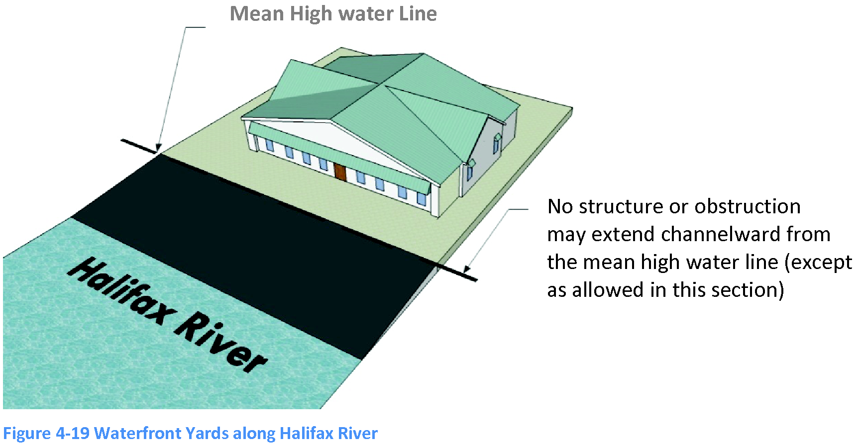
(Ord. No. 2014-01, § 2(Exh. A), 1-16-2014)
4.11.3 - Construction in waterfront yards abutting the Atlantic Ocean.
A.
On properties abutting the Atlantic Ocean, no principal structure shall be located seaward of a straight line determined by a sealed land survey, connecting the seaward-most portions of the closest adjacent principal structures to the north and south of the proposed construction site.
B.
The applicant for a permit for construction on any property within the Town of Ponce Inlet, Florida, abutting the Atlantic Ocean, shall provide as a part of the application, a survey identifying the setback and the proposed structures.
C.
Within the area between the mean high water line and the building line as determined in subsection A above, no permitted structure nor finished grade shall exceed the height of a 1:10 slope as measured westerly from the allowable seawall height at the FDEP coastal construction setback line to the required building line.
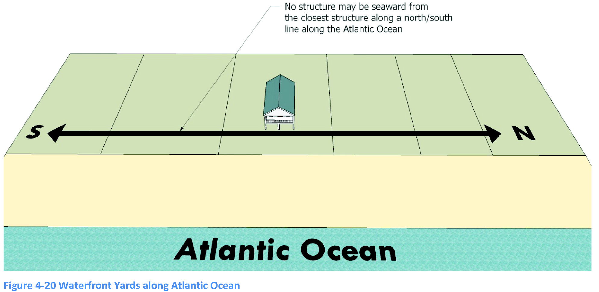
4.11.4 - Construction seaward of the Atlantic Ocean bulkhead line.
No revetment, retaining wall, vehicular access, ramp approach, walkway, pipe railing, or other principal structure or obstruction shall extend seaward of the setback line as defined by these regulations except as provided below:
A.
Steps for pedestrian use may be constructed parallel to the setback line but shall project no more than four feet seaward of said setback line;
B.
The Town of Ponce Inlet may construct and maintain structures seaward of the setback line as necessary to protect public property or to further the use and enjoyment of the Atlantic Ocean beach by the public;
C.
The chief building official may issue a temporary permit not exceeding 90 days from the date of issuance to allow the construction of a temporary vehicular ramp from the Atlantic Ocean beach for the purpose of construction and landscaping.
4.12.1 - Sand and soil retention on construction sites.
The following provisions are intended to prevent the migration and movement of loose sand, soil and construction debris from the construction sites to neighboring properties or adjoining roads as a result of high winds and heavy rains:
A.
In general.
1.
Erosion control methods shall be employed on all construction sites that include clearing and/or grading activities that expose soil to wind and rain.
2.
The specific methods employed shall be in accordance with the town's adopted standard construction details for site clearing, grading, and erosion control design and construction.
3.
Erosion control methods shall be installed prior to any construction, excavation, or demolition activity.
B.
Temporary sand fencing.
1.
In locations exposed to strong prevalent winds, such as the Atlantic Ocean coastline, the building official may require temporary sand fencing to be installed in addition to the methods referenced above.
a.
This requirement does not apply to the side facing the beach on coastal properties.
b.
The location of required sand fencing may be waived in locations where the property is surrounded sufficiently by heavy vegetation to preclude drifting or blowing sand, soil or debris.
2.
A building permit shall be required prior to the erection of the temporary sand fence.
3.
Approved fence materials shall include opaque privacy fencing or other semi-permanent materials deemed appropriate by the director. For construction activity of significant size or duration, the director may require the fence to be constructed of properly braced plywood, stockade or board-and-batten fences painted an earth-tone color.
4.
Fencing shall be sufficiently high to block the wind-blown movement of sand from the property onto adjacent properties and rights-of-way.
5.
Street addresses shall be placed on the fence near the entrance of the construction site.
6.
Required sand fencing shall be removed when vegetation or other sand and soil stabilization is sufficient, as determined by the director, to adequately control migration and movement of sand.
7.
If the fence is not properly maintained in an upright position with all screening materials fully attached, or the fence is not in working order, a stop work order shall be issued for the construction site until the fence is determined to be in proper working order as originally permitted.
8.
In periods of emergency or severe weather, the town may require or take additional temporary emergency measures to prevent the movement or migration of sand, soil or construction debris, etc., onto neighboring properties or adjoining streets, and charge the permittee the reasonable cost of taking these measures.
9.
If the town in its discretion deems it necessary, the town may upon notice to the property owner, install or remove a temporary sand fence to comply with the requirements of this code at the expense of the property owner.
10.
A temporary sand fence shall in no way relieve the property owner from performing other construction-related activities that are required by this code or requirements from other jurisdictional agencies. Property owners are responsible for maintaining the property so as not to create a nuisance or unsightly condition on either their property or adjacent properties.
4.12.2 - Excavations in public rights-of-way.
A.
Collector and subcollector roads shall not be closed during the process of excavation or construction within the public right-of-way unless the closing is approved by the town council.
B.
The persons making excavations or performing construction work within the right-of-way shall erect and maintain proper, safe, and sufficient barricades, signage, flagmen and lighting around the barricades, work or excavation to warn persons of the presence of the excavation and work and to prevent injury to persons and property.
C.
The persons making excavations or performing construction work within the right-of-way must comply with the regulations set forth in the most recently adopted State of Florida "Manual on Traffic Control and Safe Practices for Street and Highway Construction, Maintenance, and Utility Operations" prepared by the State of Florida, Department of Transportation.
D.
If the road must be closed temporarily, the contractor must provide the town council with the following information for its consideration:
1.
A graphic description of the road to be closed;
2.
The exact day and time that the road will be temporarily closed;
3.
Notice of the closing by publication to the public upon council's approval;
4.
Provisions for detour and detour signage;
5.
Reasons necessitating closure;
6.
Recommendation of the town engineer, fire chief, police chief and director regarding the proposed application for the temporary closing of the road;
7.
Proposed signage, lights, barricades, etc., warning of the excavation/construction activity; and
8.
Any alteration of the normal flow of traffic, with a graphic description of the traffic pattern.
E.
A collector or subcollector road shall not be closed between one-half hour after sunset and one-half hour before sunrise. This prohibition may be waived by the town council upon the applicant's demonstration of the eight factors listed in subsection 4.12.2.B above and extreme hardship. In determining whether the applicant has demonstrated extreme hardship, the council must find that the night closing shall not substantially affect the ingress or egress of surrounding, adjacent property owners and that the night closing will not be contrary to the public safety.
F.
The person making excavations or performing construction work within the right-of-way shall restore the right-of-way after completion of construction to its original grade and shall not alter or obstruct the paved or unpaved right-of-way in any manner.
4.13.1 - Intent.
The intent of this section is as follows:
A.
To recognize, protect and enhance buildings, landmarks, and sites within the town that have specific historic, archaeological, or aesthetic significance, which is expected to result in increased property values, increased economic benefits to the town and its residents, the promotion of local interests, educational and cultural enrichment of human life and the fostering of civic pride.
B.
To take advantage of all available state, county, and federal laws and programs that may assist in the development or redevelopment of the town.
C.
To fulfill the will of the people of the State of Florida, as expressed in the Florida Constitution Art. II, § 7, that the state's natural resources and scenic beauty be conserved and protected.
D.
To support the will of the Florida legislature, as expressed in F.S. ch. 267, that Florida's historic sites and properties, buildings, artifacts, treasure troves and objects of antiquity that have scientific or historic value, or are of interest to the public, be protected and preserved.
4.13.2 - Purpose.
The purpose of this section is to recognize, protect and enhance properties with historic, archeological or aesthetic significance. Additionally, the purpose of this section is to promote the health, safety, economic, educational, aesthetic, cultural and general welfare of the public through the:
A.
Identification, protection, enhancement, perpetuation and use of districts, sites, buildings, structures, objects and areas that are reminders of past eras, events and persons important in local, state or national history, or that provide significant examples of architectural styles of the past, or that are unique and irreplaceable assets to the town and its neighborhoods, or that provide this and future generations examples of the physical surroundings in which past generations lived;
B.
Enhancement of property values, the increase of economic and financial benefits to the town and its inhabitants, and the promotion of local interests;
C.
Preservation and enhancement of varied architectural styles, reflecting the town's cultural, social, economic, political and architectural history; and
D.
Enrichment of human life in its educational and cultural dimensions by fostering knowledge of the living heritage of the past.
4.13.3 - Maintenance and repair of landmarks, landmark sites and property in historic districts.
A.
Every owner of a landmark, a landmark site or a property in a historic district shall keep in good repair:
1.
All of the exterior portions of such buildings or structures;
2.
All interior portions that, if not so maintained, may cause such buildings or structures to deteriorate or to become damaged or otherwise to fall into a state of disrepair; and
3.
In addition, where the landmark is an archeological site, the owner shall be required to maintain his property in such a manner so as not to adversely affect the archeological integrity of the site.
B.
The historic board may refer violations of this section to the building division for enforcement proceedings.
C.
This section applies in addition to the provisions of the building code requiring the buildings and structures to be kept in good repair.
4.14.1 - Protection of gopher tortoise.
4.14.1.2. Purpose and jurisdiction.
In 2007, the Florida Fish and Wildlife Conservation Commission (FWC) listed the gopher tortoise as a threatened species and created a plan to manage and protect these reptiles. The plan includes guidelines for landowners whose property contains gopher tortoises to ensure they are protected, and their habitat needs are maintained.
The purpose of this subsection is to enhance the protection mechanism of the threatened gopher tortoises and their habitat at the local level.
4.14.1.3. Penalty.
Violations of this article are punishable as provided in F.S. ch. 162, article V (Code Enforcement) of the Town's Code of Ordinances, and article 8 (Enforcement) of the Land Use and Development Code. The FWC rules, policies, guidelines and other state laws including F.S. ch. 379 [2] also apply.
4.14.1.4. General prohibitions.
Unless otherwise authorized by a permit, the FWC rules, policies or guidelines, or applicable state laws, no person shall be allowed to:
(1)
Take, attempt to take, pursue, hunt, molest, capture or intentionally kill gopher tortoises or destroy their eggs;
(2)
Transport or move a gopher tortoise; or
(3)
Clear land, operate heavy equipment, or pursue construction activity within 25 feet from the opening of any gopher tortoise burrow without first obtaining a valid permit from the FWC or an affirmation that no such permit is necessary.
4.14.1.5. General exemptions.
The following activities are exempt from permitting requirements:
(1)
Linear utility and right-of-way vegetation maintenance such as mowing grass and trimming trees that are in accordance with the current FWC guidelines.
(2)
Site preparation activities such as hand trimming of vegetation to determine the suitability of a property for development or to conduct required surveys, if they do not harm the existing gopher tortoise burrows.
(3)
Typical activities associated with residential lawn and landscape maintenance that do not require a town permit, provided they do not harm gopher tortoises or cause the collapse of their burrows.
(4)
Development activities which are permitted by the town outside of a 25-foot radius buffer from the mouth of all burrows which meet the current FWC guidelines [3].
4.14.1.6. Standards for review.
(1)
All applications for subdivision, development, or redevelopment except for single-family residential use are required to include a biological survey conducted by a qualified wildlife biologist documenting the types of habitat on the site and the presence of any protected or endangered species, including gopher tortoises. The survey must mark the exact location of their nests or burrows.
(2)
For all new single-family residential development and redevelopment, a gopher tortoise survey must be completed in conjunction with the required tree survey by a licensed land surveyor. The survey must mark the location of any existing burrows.
(3)
If based on the survey and examination by staff, gopher tortoises or their burrows are determined to be present on the site, the applicant must apply for a gopher tortoise permit from FWC. No site work including clearing, tree removal, or grading activity shall be allowed until it is authorized by FWC.
4.14.1.7. Standards for gopher tortoise protection during development activities.
The following are minimum standards necessary to protect gopher tortoise burrows from damage during any development activities:
(1)
Gopher tortoise protection zones. A permit from the FWC may not be required if the proposed development activity is outside of a 25 feet protection zone from the mouth of all burrows. No construction activity or other disturbance is permitted within this protection zone.
(2)
Temporary barriers. A temporary barrier shall be constructed around the 25-foot radius protection zone to prevent physical damage from equipment and other activities incidental to development. The barrier must meet the FWC standards and shall be subject to inspection by the town prior to any clearing. The barriers must be completely removed from the site at the end of the construction, unless otherwise authorized.
(3)
Gopher tortoises and burrows damaged during construction. If any gopher tortoise burrows are impacted or any gopher tortoise injury or mortality occurs during development, the applicant shall immediately notify the FWC and the town's planning and development department. A "stop work order" shall be issued and posted on the site and shall remain in effect until the FWC law enforcement has completed its investigation and the matter is fully resolved.
4.14.1.8. Appeals.
Any decision or determination made by the planning and development department staff may be appealed in writing within 30 days of said determination to the planning board (board) in accordance with article 6 of the Land Use and Development Code. The board may uphold, modify or reverse the determination of the staff. Appeals of decisions of the board shall be as provided in section 6.3.7 of the Land Use and Development Code.
4.14.1.9. Relation to Florida Administrative Code.
(1)
It is the intent of the town that this section be consistent with, and in furtherance of the provisions of Rules 68A-27.003, 68A-27.004, and 68A-27.005, of the Florida Administrative Code (F.A.C.) [4], and that it satisfies any obligation the town may have under these provisions to prevent harm to gopher tortoises by its election to adopt this regulation.
(2)
Nothing in this article shall be construed to authorize or license any act prohibited by the Florida Administrative Code or the Endangered Species Act.
(Ord. No. 2019-03, § 2, 4-18-2019)
Note— http://www.leg.state.fl.us/statutes/index.cfm?App_mode=Display_Statute&URL=0300-0399/0379/0379ContentsIndex.html
--- (3) ---
Note— https://myfwc.com/media/11854/gt-permitting-guidelines.pdf
--- (4) ---
Note— https://www.flrules.org/gateway/ChapterHome.asp?Chapter=68A-27