
Ponce Inlet City Zoning Code
ARTICLE 9
DEFINITIONS AND RULES OF INTERPRETATION
SECTION 9.2. - RULES OF MEASUREMENT
The rules for measuring building height, building area, yards, building and structure density, and setbacks are set out in article 4.
SECTION 9.3. - INTERPRETATION OF USES
A.
Any use that is not specifically permitted by the LUDC is prohibited.
B.
The town recognizes that new types of land use will develop and forms of land use not anticipated in the LUDC may seek to locate in the town. When application is made for a use not specifically listed in the zoning district regulations, the director may render an interpretation that the use is substantially similar to a permitted use. In making the interpretation, the director shall consider the nature of the use and whether it involves:
1.
Dwelling activity;
2.
Sales;
3.
Processing;
4.
Type of product, storage and amount, and nature of products;
5.
Enclosed or open storage;
6.
Anticipated employment;
7.
Transportation requirements or trip generation;
8.
The amount of noise, odor, fumes, dust, toxic material, and vibration likely to be generated; and
9.
The general requirements for public utilities, including water and sanitary sewer.
C.
Standards and approval procedures for new and unlisted uses are the same as those for the substantially similar listed use.
SECTION 9.4. - DEFINITIONS
The following terms have the following meanings:
AASHTO. The American Association of State Highway and Transportation Officials.
Abandon. The voluntary, intentional discontinuance of an existing land use or structure, which may include the following:
a.
Failure to pursue or obtain necessary permits, licenses, or other governmental approvals;
b.
Failure to secure the property against trespass and vandalism;
c.
Failure to pay property taxes or other governmental taxes or assessments;
d.
Severance of electrical, water, or other utility services; or
e.
Any other actions or inactions that are considered a voluntary discontinuance or abandonment of a use under Florida law.
Abut (or "abutting"). To physically touch or border upon, or to share a common property line.
Access. The principal means of ingress and egress to a property from a public or private right-of-way.
Accessory. See definition, section 3.2.
Accessory use or accessory structure. See definition, section 3.2.
Active pool slips. See definition of "Boat slip," section 3.9.
Addition (to an existing building or structure). Any vertical or lateral expansion to the existing building or structure that increases its area and/or height.
Adjacent. See "Abut."
Adult day care. See definition, section 3.22.
Adult family care home. See definition, section 3.22.
Adult use. See definition, section 3.3.
Adverse effects. For the purposes of environmental and historic resource protection, any modifications, alterations, or effects on waters, associated wetlands, or shore land, including their quality, quantity, hydrology, surface area, species composition, or usefulness for human or natural uses which are or may potentially be harmful or injurious to human health, welfare, safety or property, to biological productivity, diversity, or stability or which unreasonably interfere with the reasonable use of property, including outdoor recreation. The term includes secondary and cumulative as well as direct impacts. Additionally, any changes in the physical characteristics of historic buildings or land that diminish those characteristics which give the property its historic significance are an "adverse effect."
Aeronautical study: See definition, section 2.17.
Aggrieved person oraggrieved party. Any person or local government that will suffer an adverse effect to an interest protected or furthered by the town's comprehensive plan, including interests related to health and safety, police and fire protection service systems, densities or intensities of development, transportation facilities, health care facilities, equipment or services, and environmental or natural resources. The person's or party's interest must be specific and personal, and not common to all members of the community. The term includes the owner, developer, or applicant for a development order.
Agricultural lands. Lands classified as agricultural by the county property appraiser in accordance with F.S. § 193.461, for agricultural uses, including forest management, and limited agricultural uses under the comprehensive plan.
Agriculture. As described in the comprehensive plan, "agriculture" is limited to mariculture, beekeeping, animal husbandry, groves and nurseries, and does not include row crops. See also "mariculture."
Airport. See definition, section 2.17.
Airport elevation. See definition, section 2.17.
Airport hazard. See definition, section 2.17.
Airport hazard area. See definition, section 2.17.
Airport layout plan. See definition, section 2.17.
Alley. A narrow right-of-way typically located mid-block, used to provide a secondary means of access and services to abutting property.
Alteration. Any changes in structural parts; type of construction; kind or class of occupancy. The word "alteration" includes the words "alter," or "reconstruct."
Amendment (development plan, subdivision plat, site plan, LUDC). A change to a previously approved development plan, subdivision plat or site development plan, or a revision to the text of the LUDC.
Animal kennel. Any structure or premises, in which animals are boarded, groomed, bred, or trained for commercial gain.
Animals. For the purpose of the LUDC, includes, household pets; wildlife; species listed by the state and/or federal government as endangered, threatened, or of special concern; and those specifically related to limited agricultural activities as described in the comprehensive plan.
Apartment. A room or suite of rooms within a multi-family dwelling used as a dwelling unit for one family with facilities for living, sleeping and cooking.
Applicant. The owner of land or authorized representative applying for a development permit.
Application for a development permit. The completed form or forms and all accompanying documents, exhibits, and fees required of an applicant by the appropriate town department, board, or commission as part of the review for a development permit, certificate, or approval authorized under this code.
Aquifer. An underground geologic formation that is permeable enough to transmit, store, or yield usable quantities of water.
Area of shallow flooding. A zone designated AO or AH on the flood insurance rate map (FIRM) with base flood depths from one to three feet where a clearly defined channel does not exist, where the path of flooding is unpredictable, and where velocity flow may be evident. This flooding is characterized by ponding or sheet flow.
Area of special flood hazard. The land in the floodplain within the town subject to a one percent or greater chance of flooding in any given year.
Artificial drainage system. Any canal, ditch, culvert, dike, storm sewer or other manmade facility which tends to control the surface flow of water.
As-built plans. The construction drawings specifying the locations, dimensions, elevations, and capacities of all public improvements as they have been constructed and installed.
Assisted living facility. See definition, section 3.22.
Automobile. A self-propelled, free-moving vehicle, with four wheels, used to transport passengers and licensed as a passenger vehicle.
Average daily trips. The average number of vehicles that pass a specified point during a 24-hour period, as measured for at least 72 continuous hours between Monday 6:00 p.m. and Friday at 6:00 a.m., excluding legal holidays.
Awning. A roof-like cover that projects from the wall of a building to shield a doorway, walkway or window from the elements. (See also "canopy" and "marquee.")
Bar. A premises devoted primarily to the retailing and drinking of alcoholic beverages for consumption on the premises, along with the incidental serving of food. The word "bar" is considered synonymous with the words "barroom," "cabaret," "cocktail lounge," "lounge," "pub," "saloon," and "tavern."
Base flood. The flood having a one percent chance of being equaled or exceeded in any given year (also called the "100-year flood").
Basement. That portion of a building having its floor below ground level on all sides.
Beach. That area of unconsolidated material that extends landward from the mean low water line to where there is a marked change in material or physiographic form, or to the line of permanent vegetation (usually the effective limit of storm waves).
Beach berm. A bare, sandy shoreline with a mound or ridge of unconsolidated sand that is immediately landward of and usually parallel to the shoreline and beach. The sand is calcareous material that is the remains of marine organisms. The berm may include forested, coastal ridges and may be colonized by hammock vegetation.
Bed and breakfast inn. See definition, section 3.5.
Beneficial functions of a protected environmentally sensitive area. Those functions, described in the coastal management/conservation element of the comprehensive plan, that justify designating an area as environmentally sensitive.
Best management practices (BMP). State-of-the-art technology and methods as applied to a specific problem. For the purposes of the town's stormwater management and conservation regulations, BMPs specifically refer to a practice or combination of practices determined by the town engineer to be the most effective, practical means of preventing or reducing the amount of pollution generated by a development project to a level compatible with Florida water quality standards (F.A.C. ch. 62-302).
Bicycle facilities. Improvements and provisions that accommodate or encourage bicycling, including parking and storage facilities, bicycle paths (bikeways), and bike lanes.
Bicycle path (bikeway). That portion of a right of way, crosswalk area and the like, separated from streets, intended for the use of bicycles and for pedestrians.
Block. A tract of land bounded by streets, or by a combination of streets and public parks, shorelines of waterways, or other definite barriers.
Boarding house. See definition, section 3.22.
Boardwalk. See definition of "Elevated boardwalk," section 3.19.
Boatel. See definition, section 3.6.
Boat construction. See definition, section 3.7.
Boat ramp. Publicly or privately owned boat launching lanes that provide direct access to the inland waterway, usually developed in conjunction with parking facilities.
Boat rental. Keeping of boats in readiness to be hired without crews (bareboat charters).
Boat repair facilities. See definition, section 3.8.
Boat slip. See definition, section 3.9
Boat slip registry. The town's official record of all existing and available undeveloped boat slips. See also section 3.9.3.
Boat storage. See definition, section 3.10.
Boat, vessel, or watercraft residence. See "Residences on boats in the water."
Boathouse. See definition, section 3.17.
Boat yard. A premises or site used for facilities that are customary and necessary to the construction, reconstruction, repair, maintenance, or sale of boats, marine engines, or marine equipment and supplies of all kinds, including, but not limited to rental of covered or uncovered boat slips, dock space, enclosed dry storage space, or lifting or launching services, and for dredge or barge dockage or storage.
Bond. Any form of security including a cash deposit, surety bond, collateral, property or instrument of credit.
Boulevard. A street in which a landscaped median may be included within the right-of-way to separate opposing traffic lanes.
Boundary survey. A survey, the primary purpose of which is to determine the perimeters of a parcel or tract of land by establishing or re-establishing corners, monuments, and boundary lines to describe, locate fixed improvements, or plat or divide the parcel. A boundary survey is certified by the registered surveyor in charge as meeting the "minimum technical standards" set forth by the Florida Board of Land Surveyors, pursuant to F.S. § 472.027.
Breakaway wall. A wall that is not part of the structural support of the building and is intended through its design and construction to collapse under specified lateral loading forces associated with the design storm surge without causing damage to the elevated portion of the building or the supporting foundation system. Under such conditions, the wall will fail in a manner such that it dissolves or breaks up into components that will not act as potentially damaging missiles.
Buffer. An area consisting of landscaping, walls, fences, or berms that ensure protection against real or potential incompatibility between adjoining land uses of different types and/or intensities of development.
Buffer, landscaped. A buffer that is required to be landscaped (see article 4).
Bufferyard. The area around the perimeter of a property where landscaping coverage, buffers, screening, installation and inspection requirements are applied.
Building. A structure whether portable or fixed, enclosed within exterior walls and a roof that is built, erected and framed of a combination of materials, to form a structure for the shelter of persons, animals, or property. A reference in this Article to a "building" means either the entire building or part of the building, unless otherwise stated.
Building, accessory. Any building on a piece of property other than the principal building.
Building area. See definition, section 4.6.10.
Building, principal. Any building containing the principal use of the lot on which it is situated. In a residential district any dwelling is the principal building. Any attached carport, shed, garage or any other structure that shares one or more walls with the principal building and is structurally dependent on the principal building, is considered part of the principal building and is subject to all regulations applicable to the principal building. A detached and structurally independent garage, carport, or other structure which is attached to the principal building by an open breezeway in excess of six feet and/or enclosed on one or both sides, including louvers, lattice or screening, causes the entire structure to be considered the principal building and become subject to the regulations applicable to the principal building.
Building height orheight of building. See definition, section 4.6.12.
Building line. See definition, section 4.6.10.
Building separation. The space between the multiple buildings on a single lot including all appurtenances such as balconies, overhangs, walkways and bay windows.
Building setback line. That line parallel to the lot line at the distance established by the minimum yard requirements of a given zoning district. (See the definition of "yard").
Bulk regulations. The standards and regulations that establish the maximum size of buildings and structures on a lot and the buildable area within which the building can be located, including coverage, setbacks, height, floor area ratio, and yard requirements.
Bulkhead line. On land abutting the Atlantic Ocean, this term refers to the line established by the South Peninsula Zoning Commission and recorded in the public records of Volusia County in Map Book 26, Pages 102—105 on June 9, 1965. On land abutting the Inlet and/or Intracoastal Waterway or their arms, canals or tributaries, the bulkhead line means the mean high water line. Also refers to the line established by the Trustees for the Internal Improvement Trust Fund of the State of Florida beyond which no filling waterward of the mean high water line or ordinary high water line may occur, except upon compliance with F.S. ch. 253.
Business services. Any commercial activity primarily conducted in an office, not involving the sale of goods or commodities available in the office, and not dispensing personal services. Examples include real estate brokerage, insurance, accounting, financial institutions, or similar uses.
Cafeteria. A type of restaurant in which a variety of foods and beverages is prepared in advance and then selected by customers from a buffet for consumption on the premises. See also definition of "Restaurant," section 3.26.
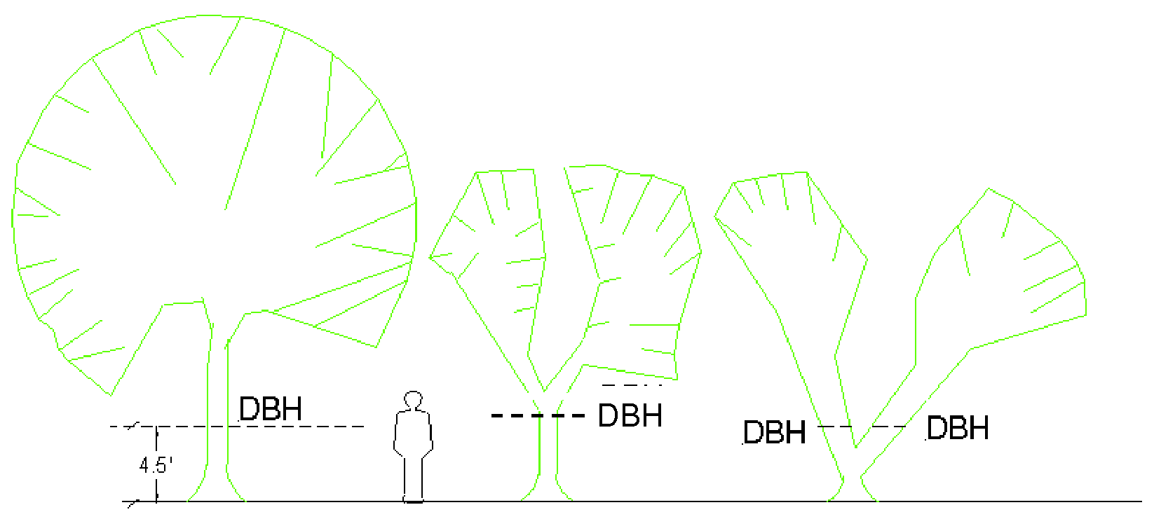
Caliper. The diameter of a tree trunk measured in inches. For trees less than four inches in diameter, caliper is measured six inches above the soil line. For trees greater than four inches in trunk diameter, caliper is measured 12 inches above the soil line.
Camper. See "travel trailer."
Cannabis. Any plant or part of a plant of the genus Cannabis, whether growing or not; the seeds thereof; the resin extracted from any part of the plant; and every compound, manufacture, salt, derivative, mixture, or preparation of the plant or its seeds or resin.
Cannabis farm. Any property used in whole or in part for the growing or cultivation of Cannabis plants, whether or not such growing or cultivation is lawful under federal or state law.
Canopy. A permanent roof structure that may be freestanding, attached to a building, or supported in whole or in part by a building and which projects from the wall of a building to shield a doorway or windows from the weather (See also "awning" or "marquee").
Capital improvement. Any physical asset constructed or purchased to provide, improve or replace a public facility, and which is of relatively high, non-recurring cost, often requiring multi-year financing.
Capital improvements program (CIP). A schedule of permanent public improvements budgeting established by the town that does not exceed its financial capabilities. The CIP is projected five years in advance and updated annually.
Carport. A roofed structure providing space for the storage of motor vehicles and enclosed on no more than three sides.
Casino. Any premises where gambling is conducted.
Census. The official count of the population, its age, sex, and social and economic characteristics, conducted on a decennial basis by the Bureau of the Census of the U.S. Department of Commerce.
Certificate of appropriateness. A written authorization by the historic and archaeological preservation board to the owner(s) of a designated property, or a property within a designated historic district or area, allowing a proposed alteration, new construction, demolition or relocation of a building, structure or site.
Certificate of occupancy. The official certification that a premise conforms to the LUDC and the Florida building code and may be used or occupied. The certificate is issued for new construction or for alterations or additions to existing structures, and a change in use.
Certificate to excavate. A certificate issued by the historic and archaeological preservation board authorizing certain clearing, digging, excavation or archaeological investigation that may involve the exploration of established or suspected archaeological sites which have been designated as historic resource.
Change of use. The change in the use of a structure or land from one use to another use listed in the tables of uses as a permitted use.
Chief building official. The chief building official of the town or his duly authorized representative charged with the administration and enforcement of the Florida Building Code, namely the permitting and inspection of construction, alteration, repair, remodeling, or demolition of structures, pursuant to F.S. § 468.604.
Child care center. See section 3.11, Table 3-3.
Child care facility. A facility for the care of more than five children recognized by the State of Florida, pursuant to F.S. § 402.302. Categories of child care facilities include child care centers, family day cares, and large family child care facility.
Civic assembly. See definition, section 3.12.
Clearing. The removal of any trees or brush from the land. This does not include mowing or other maintenance activities that are exempt from permitting as provided in section 4.10.4. See also "land clearing."
Clear trunk. A measurement of palm trees taken from the natural soil line to the base of the lowest living fronds.
Clinic, medical or dental. A premises where patients are admitted for out-patient examination and treatment by one or more persons practicing any form of the human healing arts, whether they are medical doctors, chiropractors, osteopaths, chiropodists, optometrists, dentists, or any similar professional licensed by the State of Florida. The term does not include a veterinarian clinic.
Clinic, veterinary. See "Veterinary clinic."
Club, private. See "Private clubs."
Cluster development. A development design technique allowing for compact arrangement of dwelling units by utilizing reduced lot requirement standards of the applicable zoning district, with a corresponding greater amount of common open space. See also definition of "Residential cluster subdivisions," section 3.25.
Coastal beach accessway. Facility that provides access to the coastal beach.
Coastal construction control line. That legally-described line along Ponce Inlet's Atlantic coastal beach area established by the State of Florida pursuant to F.S. § 161.053, and east of which the erection of any structure requires prior approval from an agency of the State of Florida.
Coastal high hazard area. An area of special flood hazard extending from offshore to the inland limit of a primary frontal dune along an open coast and any other area subject to high velocity wave action from storms or seismic sources (e.g. tsunami). These include all areas designated on a flood insurance rate map as V1-V30, VE or V. The coastal high-hazard area is the area below the elevation of the category 1 storm surge line as established by a Sea, Lake, and Overland Surges from the Hurricanes (SLOSH) computerized storm surge model.
Commercially developed parcel. A parcel of property on which there is at least one walled and roofed structure used, or designed to be used, for other than residential or agricultural purposes.
Commercial fish processing plant. A premises used for the receiving, processing, packaging, storage, and wholesale or retail distribution and sale of sea and fresh water food products.
Common open space. A commonly owned area of land reserved primarily for the leisure or recreational use of the owners of a residential, commercial, or mixed-use development.
Community character. The image of a community or area as defined by factors including its built environment, natural features and open space elements, type of housing, architectural style, infrastructure, and the type and quality of public facilities and services.
Community residential home. See definition, section 3.14.
Comprehensive plan. The long-range planning guide prepared and adopted by the Town of Ponce Inlet pursuant to F.S. ch. 163, part II.
Concept plan. A preliminary plan for the development of property that may be submitted optionally for review in order to obtain constructive, non-binding feedback only. Concept plans indicate contour lines; any significant natural features, such as stands of trees, wetlands and dunes; proposed building layouts with approximate square footages of floor area; proposed off-street parking areas and off-street loading areas; and the proposed internal circulation system within the lot.
Concurrency. A condition where specified facilities and services have or will have the necessary capacity to meet the adopted level of service standard at the time the impacts of the development project occur.
Concurrency management system. The procedures and process that the town utilizes to assure that development orders and permits will not reduce the town's infrastructure and service capacity below the adopted level-of-service standards at the time that the impact of development occurs.
Condominium. A form of property ownership which is comprised entirely of units that may be owned by one or more persons, and in which there is an undivided share in common elements appurtenant to each unit.
Conservation use. Activities or conditions within land areas designated to conserve or protect natural resources or environmental quality, including areas designated for flood control, floodplain management, and protection of water quality, commercially and recreationally valuable fish and shellfish, vegetative communities and wildlife habitats. These areas may include surface waters, wetlands, floodplains, flood-prone areas, areas subject to severe erosion from action of waves and currents, and adjacent uplands needed to conserve habitat for threatened or endangered species or to preserve natural drainage links with protected wetlands. This use is designated on the town's existing and future land use map as "Conservation," and includes salt water marshland, as well as mangrove areas. It also contains land that, for much of the year, is high and dry.
Construction, start of. The duly-permitted permanent placing or erection of construction materials into position. When excavation or removal of an existing structure commences in preparation for new construction, the excavation or removal is considered the start of construction if work continues uninterrupted for a period longer than 30 days, until the new construction is completed. The term includes built, constructed, reconstructed, moved upon or any physical operation on the premises required for building.
Contiguous. See "Abut."
Convenience store. A retail establishment that usually sells a limited selection of items or brands of pre-packaged or prepared foods, ready-to-eat foods, snacks, gum, candy, beverages, dairy products, and sundries, all of which are frequently purchased for immediate consumption. A convenience store is not developed with facilities to dispense and sell vehicular fuel, or for the sale and/or installation of tires, batteries or similar accessories. Such stores are typically open for extended daily hours of business (12 to 24 hours), and normally situated as a single entity or in a "strip building" configuration.
Conversion. The change of a building, structure or lot from one use or purpose to another.
Courtyard. See definition, section 3.16.
Coverage. See "Lot coverage."
Critical facility. A facility for which even a slight chance of flooding is unacceptable. Critical facilities include, but are not necessarily limited to schools; nursing homes; hospitals; police, fire and emergency response installations; and installations which produce, use or store hazardous materials or hazardous waste.
Crosswalk. That portion of the right-of-way dedicated to, and intended primarily for pedestrians to cross from one side to the other.
Crown, tree. The main mass of branching of a tree above the ground.
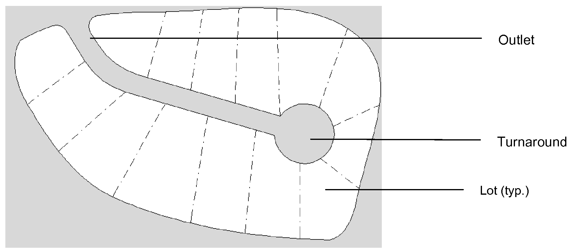
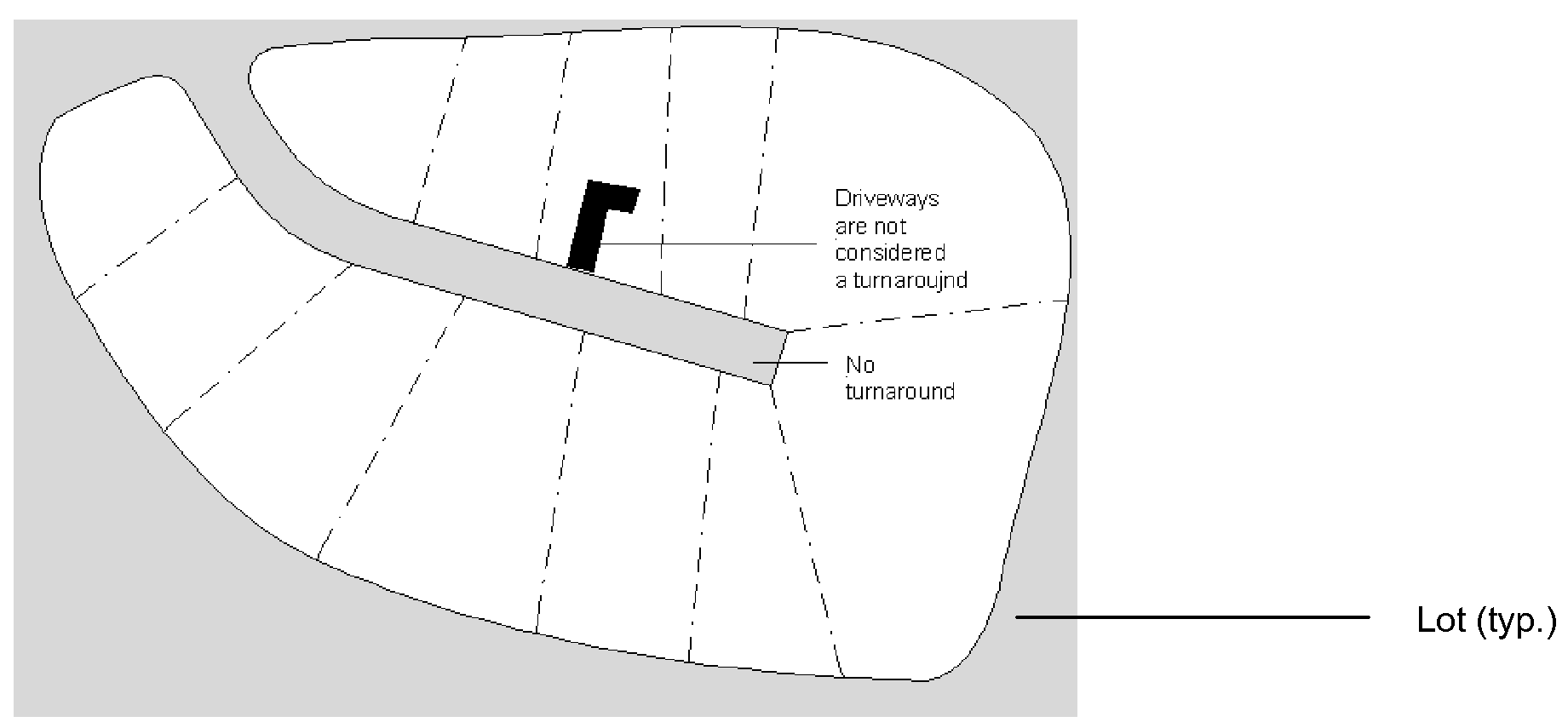
Cul-de-sac. A local street with only one outlet and having a properly sized turnaround for the safe and convenient reversal of traffic movement. A dead-end street is not considered a cul-de-sac.
Cultural resource. A site, object, structure, building or district listed on the town's "survey of cultural resources" or on the local register of historic places.
Damaged plant. Any plant that has been damaged or neglected, resulting in severe decline, disfigurement, discoloration, defoliation, or death of the plant. Neglect includes failure to properly water, fertilize, control pests and fungus, or prune. Damage includes physically or chemically damaging a plant through hat racking, burning, cutting, scarring, painting, or poisoning.
Date of rendition. The date on which a decision or recommendation is voted on and/or made by a review board, official, or agency under the LUDC.
Dead-end street. A roadway having only one means of vehicular access with the other end simply terminating, with no provision made on the roadway to turn motor vehicles.
Decision height. See definition, section 2.17.
Decision or recommendation. The executive action taken by the board on an application regardless of whether that decision or recommendation is immediately reduced to writing.
Deck. A platform that:
A.
Is attached to or subordinate to a dwelling unit, and
B.
Has no roof or walls except for visual partitions or railings, and
C.
Is constructed on piers, posts, or an above-grade foundation, and
D.
Is useable as an outdoor living area.
If a platform meets the definition of a "deck" under subsections A, C and D above, but is enclosed by walls or a roof, it is considered a "floor" for purposes of the LUDC.
Dedication. The transfer of property interests from private to public ownership for a specific public purpose. The transfer may be of fee-simple interest or of a less than fee-simple interest, including an easement.
Dedication, fee in lieu of. Payments in cash as an alternative to dedication of land or construction of improvements.
Delicatessen. A retail service facility where foods such as meats, sandwiches, cheeses, salads, and fish are prepared and sold, or where these foods are sold in a ready-to-eat state. This may include on-site consumption as an accessory use where the seating provided is for 20 customers or less. Customer seating for more than 20 customers makes the business a restaurant.
De minimis impact. For the purposes of the town's concurrency management system, a minor, negligible increase in the usage of public infrastructure created by new development. The construction or renovation of a single-family home on any single-family lot existing as of November 18, 2008, (the comprehensive plan adoption date) is considered de minimis.
Demolition. The intentional dismantling or tearing down of all or a part of a structure and all operations incidental thereto.
Density, dwelling unit. See definition, section 4.6.15. See also "Usable land."
Department. The planning and development department of the town.
Designated protection zone. Areas on a property where trees and vegetation are protected from removal in accordance with section 4.10.
Detention. The collection and storage of surface water for subsequent gradual discharge.
Deteriorated tree. Degenerated or damaged to the point where death of the tree is imminent or to the point where the tree poses a significant hazard to life and/or property.
Developer. Any person who engages in or proposes to engage in a development activity either as the owner, contract purchaser, or as the agent of an owner of property.
Development. The carrying out of any building activity operation, the making of any relevant and significant change in the use or appearance of any structure or land, or the dividing of land into two or more parcels. The following activities or uses are also considered "development":
• A reconstruction, alteration of size, or material change in the external appearance of a structure, including, but not limited to, buildings, parking lots, stormwater conveyance and retention features, and docks.
• A change in the intensity of use of land, such as a material increase in the number of businesses, manufacturing establishments, offices, or dwelling units in a structure or on land.
• Alteration of a river bottom or of a shore or bank of a seacoast, river, stream, pond, or canal, including any "coastal construction" as defined in F.S. § 161.021.
• Commencement of drilling, except to obtain soil samples, mining or excavation on a parcel of land.
• Demolition of a structure.
• Clearing of land as an adjunct of construction.
• Deposit of refuse, solid or liquid waste, or fill on a parcel of land.
• Commencement of any land-based or water-based, water-related operation or use that increases the need for vehicular access, parking or other support facilities on the land, or increases the requirement for any public service above what is typically required. This includes, but is not limited to, charter boat operations and water craft rentals.
The following operations or uses do not involve "development:"
• Work by a highway or road agency to maintain or improve a road if the work is carried out on land within the boundaries of the right-of-way.
• Work by any utility to inspect, repair, renew, or construct on established rights-of-way or easements any infrastructure for which it is responsible, including sewers, mains, pipes, cables, utility tunnels, power lines, towers, poles, tracks, or the like.
• Work for the maintenance, renewal, improvement, or alteration of any structure, if the work affects only the interior of the structure or involves a decorative, non-structural change to the exterior color or finish.
• The use of any residential structure or land for any purpose customarily incidental to the enjoyment thereof.
• The use of any land to grow plants, crops, trees, and other agricultural or forestry products; raise livestock; or for other agricultural purposes.
• A change in use of land or structure from a use within a class specified in an ordinance or rule to another use in the same class.
• A change in the ownership or form of ownership of any parcel or structure.
• The creation or termination of rights of access, riparian rights, easements, covenants concerning development of land, or other rights in land.
Development, as designated in an ordinance, rule, or development permit, includes all other activity customarily associated with it unless otherwise specified. When appropriate to the context, "development" refers to the act of developing or to the result of development. Reference to any specific operation is not intended to mean that the operation or activity (when part of other operations or activities) is not development.
Development order. An order granting, or granting with conditions, an application for a subdivision approval, site plan approval, special exception, variance, or any other official action of the town having the effect of approving the development, use or occupancy of land or structure.
Development permit. That official town document which authorizes the commencement of construction or land alteration without need for further application and approval. Development permits include all types of construction permits (plumbing, electrical, foundation, mechanical, in addition to the building permit itself), grading and clearing permits, septic tank permits, tree removal permits, sign permits, and other permits that do not require additional approval.
Development plan. A graphic representation or map drawn to scale depicting a proposed development of land.
Development review team (DRT). The development review officials of the town, comprised of the planning and development department director, senior planner, chief building official, representative from the public works division, town engineer, police designee, fire marshal, and the City of Port Orange utilities representative. This team is responsible for review of development plan applications.
Diameter at breast height (DBH). The trunk diameter of a tree measured 4.5 feet above the average ground level at the base of the tree. However, if the trunk forks at 4.5 feet above the ground level or higher, it is measured below the swell resulting from the double stem. Stems that fork below 4.5 feet above ground level are considered separate trees.
Director. The planning and development department director. A reference to the "director" includes any designee of the director.
Direct hydrologic connection. A surface water connection which, under normal hydrological conditions, occurs on an average of 30 or more consecutive days per year. In the absence of reliable hydrologic records, a continuum of wetlands may be used to establish a direct hydrologic connection.
Discharge or discharge point. The outflow of water from a project site, aquifer, drainage basin or facility.
Dock. A fixed or floating structure, including access walkways, terminal platforms, catwalks, mooring pilings, lifts, davits and other associated water-dependent structures, used for mooring and accessing vessels, pursuant to Chapter 18-21 F.A.C.
Dockyard. Storage area for boats, naval stores, or marine-related supplies, materials, timber, or other items used or shipped in maritime commerce or recreation.
Drainage. The removal of surface water or groundwater from land by drains, grading or other means. Drainage includes the control of runoff to minimize erosion and sedimentation during and after development and includes the means necessary to prevent or alleviate flooding.
Drainage and utility plan. A plan submitted with development applications that shows the size, location, and configuration of proposed stormwater drainage and utility infrastructure.
Drainage system. Pipes, swales, natural features, and manmade improvements designed to carry drainage.
Drainage way. Any natural or artificial watercourse, trench, ditch, swale, or similar depression into which surface water flows.
Dredging. Excavation in water or wetlands. It also means the excavation or creation of a water body which is, or is to be connected to waters, directly or via excavated water bodies or a series of excavated water bodies.
Drip line. The area defined by the outermost branches of a tree canopy from where water drips to the ground. Used to estimate the horizontal extent of a tree's root system that must be protected from construction activity to avoid damaging the long-term health of the tree.
Drive-in or drive-through establishment. A retail business establishment that, by design, physical facilities, services, or by packaging procedures, encourages or permits a portion of its customers to receive services or obtain goods while remaining in their vehicles. Such establishments may include but are not necessarily limited to restaurants, banks, pharmacies, and dry cleaners.
Driveway. An area of land which provides vehicular access from the street to the off-street parking space or garage of a premises.
Drugstore (or pharmacy). A retail business where the primary activity is the filling of medical prescriptions and the sale of drugs, medical devices and supplies, and non-prescription medicines, and where non-medical products may also be sold.
Dry slip. See definition of "Boat slip," section 3.9.
Due public notice. Notice that is provided in accordance with section 6.3.5.
Dune. A mound of sand formed along the beach by ocean waves and prevailing winds. For the purposes of the LUDC, the dune extends landward of mean high water to the toe of the back dune and may or may not be vegetated.
Dune line. A line indicating the beginning of the dune system measured from the ocean water. The line is clearly defined, undisturbed, and is usually marked by the first landward presence of coastal vegetation. Where there is no clearly marked vegetation line, it is considered to be the average elevation of the vegetation lines on either side of the area, indicating the elevation reached by the highest waves. The location of the line is not affected by occasional sprigs of grass seaward of the dune, artificial fill, or other artificial changes in the natural vegetation or elevation.
Dwelling (or "dwelling unit"). A room or rooms in a building or single housing unit that form a separate and independent housekeeping establishment, designed to be occupied by one family, and containing complete, independent living facilities for sleeping, eating, cooking and sanitation. The term "dwelling" does not include hotels, motels, tourist courts or other buildings intended for short-term occupancy by transients.
Dwelling, attached. A dwelling attached to another dwelling's foundation, wall or roof, such as a duplex, townhouse, or multi-family residence.
Dwelling, detached. A dwelling entirely surrounded by open space and not attached to another dwelling's foundation, wall or roof.
Dwelling, manufactured. A dwelling fabricated in a manufacturing facility and bearing a seal certifying it is constructed to standards as adopted under the authority of F.S. ch. 553, part IV, and rules adopted by the Florida Department of Economic Opportunity under Chapter 9B-1 et seq., Florida Administrative Code.
Dwelling, mobile home. A single-family dwelling fabricated in a manufacturing facility, having a width of more than eight feet and a length of more than 40 feet, and bearing a seal certifying it is constructed either to the federal Manufactured Housing Construction and Safety Standards Code or to obsolete ANSI 119.1 Mobile Home Design and Construction Standards.
Dwelling, multi-family. A building containing three or more dwellings intended to be occupied primarily by permanent residents.
Dwelling, rental. See definition, section 3.18.
Dwelling, single-family. A building containing only one dwelling unit.
Dwelling, standard. A dwelling built on the site where it is to be occupied and constructed pursuant to the Florida Building Code and this code.
Dwelling, townhouseortownhouse. A building containing three or more single-family dwellings attached side-by-side, where each dwelling occupies the total space between the ground and roof and has its own separate entrance.
Dwelling, two-family or duplex. A building containing only two dwellings.
Dwelling unit. See "Dwelling."
Easement. Any area of a property dedicated for limited, specified use or purpose by persons other than the owner, such as for public or private utilities, access, drainage, sanitation or other uses.
Eating and drinking places. Retail establishments selling food and drink for consumption only on the premises, including lunch counters and refreshment stands selling prepared foods and drinks for immediate on-site consumption. Eating and drinking places are specific types of food establishments. They differ from take-out facilities where food is ready for consumption but eaten off the premises. Restaurants, lunch counters and drinking places operated as accessory uses in other establishments are not regarded as separate permitted principal uses, but as accessory to the principal use. See also definition of "Restaurant," section 3.26.
Eaves. The lower borders of a roof that overhangs a wall; projecting edges.
Educational facility. See definition, section 2.17.
Effective date. For decisions of the town resulting in a development order, the effective date is when the development order is recorded in the public records of Volusia County and after any mandatory appeal period has expired. For all other town decisions, the effective date is the date of rendition and after any appeal period has expired.
Efficiency dwelling unit. A dwelling consisting of one room serving as the living room, dining room, kitchen and bedroom, along with a separate bathroom.
Elevated boardwalk. See definition, section 3.19.
Elevated building. A building that has no basement and has its lowest floor elevated above the adjacent ground level by fill, solid foundation perimeter walls, pilings, columns (posts and piers), or shear walls.
Elevation. The vertical distance above or below a fixed reference level.
Elevation, architectural. A flat-scale drawing of a building exterior showing such features as the windows, doors, wall treatment, and/or the relationship of grade to floor level.
Eligible property. For purposes of historic preservation, a property that meets the criteria for inclusion on either the federal, state, or local registers of historic places, but which has not yet been formally listed.
Emergency. An unexpected situation that poses an immediate danger to life, health or property, or essential public services, and demands prompt action to prevent or mitigate loss or damage.
Emergency hazardous situation. A condition that is an immediate and substantial danger to human health, safety or welfare, or to the environment.
Eminent domain. The authority of a governmental entity to take, or to authorize the taking, of private property for a public use or purpose with just compensation to the owner.
Enclosed storage area. An area used for storage that is surrounded on all sides by a continuously connected fence or wall except for necessary pedestrian or vehicle openings.
Encroachment. Any obstruction or illegal or unauthorized intrusion in a delineated floodway, right-of-way, setback, or other defined area of land that interferes with its proper function. Specifically as it relates to floodplains, the advance or placement of uses, plant growth, fill, excavation, buildings, permanent structures, or development into a floodplain, which may impede or alter its flow capacity.
Engineer. A professional engineer currently registered under F.S. ch. 471, as amended.
Environment. The physical, social and economic conditions that exist within an area that will be affected by a proposed project or activity.
Erected. See "construction, start of."
Erosion. The wearing or washing away of soil by the action of wind, water, or gravity.
Essential utility services. Publicly owned or regulated utility distribution systems for gas, water, sewer, telephone, television, radio or electricity of 230 kilovolts or less including poles, wires, mains, drains, sewers, pipes, conduits, cable towers, antennas 70 feet or less in height, or telecommunication towers, and other similar equipment and accessories which are necessary to furnish service by the public utilities. This term does not include electric power plants, substations, water tanks, gas transfer stations, and water and sewage treatment plants, buildings, lift stations, or municipal water supply wells.
Establishment. An economic unit, generally at a single physical location, where business is conducted or services are offered.
Estuaries. Areas where fresh water meets salt water, such as bays, mouths of rivers, salt marshes, and lagoons.
Excavation. Removal or recovery by any means of soil, rock, minerals, mineral substances, or organic substances, other than vegetation, from water or land, on or beneath the surface, whether exposed or submerged.
Excavation and grading plan. A plan submitted with development applications that demonstrates compliance with the town's excavation and grading requirements, including location of silt fencing and tree protection barricades, change in slope, etc.
Existing. The average condition immediately before development or redevelopment commences.
Existing construction. For the purpose of the town's flood damage prevention regulations, any structure for which the "start of construction" commenced before May 28, 1986.
Existing grade. See "Grade."
Existing site survey. A survey that shows the same information as a boundary survey, along with the location, size, and extent of all man-made features on a piece of property, such as street pavement, sidewalks, buildings, seawalls, coastal construction control line, easements, and foundations and structures either on or adjacent to the parcel. It is certified by a registered surveyor as meeting the "minimum technical standards" set forth by the Florida Board of Land Surveyors, pursuant to F.S. § 472.027.
Existing slips. See definition, section 3.9.
Existing use. Any lawful permitted use established before the adoption of this code.
Exotic species. A species introduced to Florida from a natural range outside of Florida. Exotic species are listed on the Florida Exotic Pest Plant Council Invasive Plant List and the Florida Noxious Weed List (Florida Administrative Code 5B-57.007), which are incorporated by reference and made a part of this definition.
Exterior wall. Any wall that defines the exterior boundaries of a building or structure.
Façade. The front exterior of a building, particularly that part facing a street or courtyard.
Facility for handicapped people. Any ramp, handrail, elevator, door, specially treated surface and similar design, convenience, or device that facilitates the health, safety, access, or comfort of a handicapped person.
Family. One or more persons living together, inter-related by marriage, birth or legal adoption, and occupying one dwelling. A family may also include up to four unrelated persons living together as a single housekeeping unit occupying one dwelling unit, but not including facilities required to be licensed to serve clients of the Department of Children and Families.
Family child care home, large. A family day care home with at least two full-time child care personnel on the premises during the hours of operation, as recognized by the State of Florida pursuant to F.S. § 402.302.
Family day care home. An occupied residence in which child care is regularly provided for children from at least two unrelated families and which receives a payment, fee or grant for any of the children receiving care, whether or not operated for profit, as recognized by the State of Florida pursuant to F.S. § 402.302.
Family foster home. A private residence in which children who are unattended by a parent or legal guardian are provided 24-hour care. The term includes emergency shelter family homes, family foster group homes and specialized foster homes for children with special needs. The term does not include homes with a person who cares for a child of a friend for a period not to exceed 90 days, a relative who cares for a child and does not receive reimbursement for care from the state or federal government, or an adoptive home which is approved by the department or by a licensed child-placing agency for children placed for adoption.
Farmer's market. See definition, section 3.20.
Federal manufactured housing construction and safety standard codes. The following statutes, regulations and interpretation, all of which became effective for mobile/manufactured home construction on June 15, 1976:
• Title VI of the 1974 Housing and Community Development Act (42 U.S.C 540l, et seq.), as amended (previously known as the federal Mobile Home Construction and Safety Standards),
• Rules and regulations that implement those statutes,
• Information supplied by the home manufacturer, which is stamped and approved by a Design Approval Primary Inspection Agency, an agent of the U.S. Department of Housing and Urban Development pursuant to HUD rules, and
• Regulations and interpretations of those statutes and regulations by the Florida Department of Highway Safety and Motor Vehicles Bureau of Mobile Home Construction.
Fence. A freestanding structure designed to restrict or prevent movement across a boundary and enclose or screen areas of land. Fences are distinguished from walls by their construction materials.
Ferry and passenger terminals. A transportation facility comprising one or more berths, slips, piers, or wharves, used for transfer of people or cargo between waterborne carriers and land. Loading and unloading areas, warehouses, and storage yards are considered accessory uses. This use does not include marinas and boatyards. Terminals which service gambling vessels and sightseeing boat bases are not considered ferry and passenger terminals.
Filling. The deposit or burial of materials, such as land clearing debris, soil, rock or other solid minerals, onto any land, water or wetlands. This definition does not include land filling with garbage or similar waste matter.
Financial institutions. Establishments such as, banks, credit unions, investment companies, brokers and dealers of securities and commodities, and other similar uses.
Finished floor. See "Lowest floor."
Finished grade. See "Grade."
Fishing piers. Publicly or privately owned jetties, piers, boardwalks, or other structures provided primarily for the purpose of non-boat fishing along either the coastal beaches or the inland waterway, or other facilities along the waterway which serve as traditional locations for fishing.
Flea markets. The retail sale of merchandise from individually rented spaces or temporary structures on a lot. The term does not apply to similar activities on a temporary irregular basis by non-profit organizations, or to a homeowner's garage sale held no more than twice in any 12-month period, or to farmers markets.
Flood boundary and floodway map (FBFM). The official map on which the Federal Emergency Management Agency or Federal Insurance Administration has delineated the areas of flood hazards and regulatory floodway.
Flood hazard boundary map (FHBM). The map issued by the Federal Emergency Management Agency where the boundaries of the areas of special flood hazard have been identified as Zone A.
Flood insurance rate map (FIRM). The official map issued by the Federal Emergency Management Agency showing both the areas of special flood hazard and the risk premium zones within the town.
Flood insurance study. The official hydraulic and hydrologic report provided by the Federal Emergency Management Agency. The report contains flood profiles, as well as the FIRM, FHBM (where applicable) and the water surface elevation of the base flood.
Flood or flooding. A temporary partial or complete inundation of normally dry land from the overflow of inland or tidal waters, or from the unusual and rapid accumulation of run-off or surface waters from any source.
Flood protection elevation. The elevation of the base flood plus one foot.
Floodplain. Low-lying land subject to periodic flooding from the overflow of inland or tidal waters and the accumulation of surface water run-off from rainfall.
Floodplain management. The operation of an overall program of corrective and preventive measures for reducing flood damage and preserving and enhancing, natural resources in the floodplain. The program includes, but is not limited to emergency preparedness plans, flood control works, floodplain management regulations, and open space plans.
Floodway. The channel of a natural stream or river and portions of the floodplain adjoining the channel, which are reasonably required to carry and discharge the floodwater or flood flow of any natural stream or river without cumulatively increasing the water surface elevation more than one foot.
Floodway fringe. That area of the floodplain on either side of the regulatory floodway where encroachment may be permitted without additional hydraulic and/or hydrologic analysis.
Floor. For the purposes of the town's flood damage prevention regulations, the top surface of an enclosed, habitable area in a building. This includes the top of the slab in concrete slab construction, or the top of the wood flooring in wood frame construction. The term does not include the floor of accessory areas used exclusively for parking of vehicles (i.e., garage), limited storage, or building access (i.e., stairs, elevator shafts, or maintenance crawl space). Unenclosed outdoor seating areas do not constitute part of a "floor" unless they are covered by a roof, or are an extension of a concrete slab or wood flooring.
Floor area. See definition, section 4.6.13.
Floor area ratio (FAR). See definition, section 4.6.13.
Florida-friendly landscaping. A set of landscaping principles and best management practices designed to create sustainable landscapes adapted to Florida's environment and ecology while minimizing the use of fertilizer, pesticides, and irrigation. Florida-Friendly Landscaping principles include planting the right plant in the right place, efficient watering, appropriate fertilization, mulching, attraction of wildlife, responsible management of yard pests, recycling yard waste, reduction of stormwater runoff, and waterfront protection. Additional components include planning and design, soil analysis, the use of solid waste compost, practical use of turf, and proper maintenance.
These practices and principles are based on the Florida Yards and Neighborhoods (FYN) and Environmental Landscape Management (ELM) programs operated by the University of Florida Cooperative Extension Service, the Xeriscape programs of the state's water management districts, and practices identified in the Green Industries Best Management Practices for Protection of Water Resources in Florida (2002), as amended, and are authorized by F.S. § 166.048.
Frontage. The length of the property line of any one parcel along a street on which it borders.
Functionally dependent use. A use which cannot function as intended unless it is located or carried out in close proximity to a natural resource. For example, uses such as a docking, loading and unloading of cargo or passengers, ship building and ship repair, and seafood processing are functionally dependent on proximity to water. The term does not include long-term storage or related manufacturing uses.
Future land use district. An area identified and assigned a land use class on the future land use map of the comprehensive plan, for which is prescribed a use or range of uses and intensity of development which may be permitted.
Game or gambling game. Any banking or percentage game played with cards, dice or any mechanical device or machine for money, property or any representative of value and located within a casino.
Gaming or gambling. The dealing, operating, carrying on, conducting, or maintaining for pay of any game.
Gaming device or gambling equipment. Any mechanical contrivance or machine used in connection with gaming or gambling.
Garage, motor vehicle. A building or part of a building, within which motor vehicles are equipped, serviced, repaired, or stored. This term does not include a private storage building or a private residential garage.
Garage, parking. A building or part of a building, or area beneath a building or structure, used only for the parking of more than 20 vehicles. This term does not include a private residential garage.
Garage, private residential. A building accessory to a residential use that is used primarily to store motor vehicles for the use of the occupants on the lot on which the building is located. This includes the storage of commercial vehicles that otherwise may be used as private vehicles. However, this does not include construction equipment or vehicles of a size or type not customarily associated with private residential uses.
General office. A premises on which the administrative, managerial or professional services of a business, professional person, government, or similar activities are carried out.
Glare. The effect produced by brightness sufficient to cause annoyance, discomfort or loss in visual performance and visibility.
Golf course. An outdoor area of at least three contiguous acres that is designed and constructed to accommodate the sport of golf. The term does not include independent driving ranges or miniature golf courses, but does include clubhouses and shelters.
Government agency. Any department, commission, independent agency, or instrumentality of the United States, of the State of Florida, or of a county, authority, district, or the town.
Grade. The slope of improvements, specified in percent or feet per 100 feet expressed as a decimal. With regard to building height, "grade" means the horizontal location of the ground surface.
Adjacent grade. The ground surface next to a structure.
Existing grade. The natural grade of the land prior to alteration.
Finished grade. The final grade of the site which conforms to an approved building or development plan.
Highest adjacent grade. The highest natural elevation of the ground surface, prior to the start of construction, adjacent to the proposed walls of a structure.
Lowest adjacent grade. The lowest elevation, after the completion of construction, of the ground, sidewalk, patio, deck support, or basement entryway immediately next to the structure.
Proposed grade. The grade shown on an approved building or development plan prior to construction.
Rough grade. The stage of construction at which the grade approximately conforms to an approved building plan or subdivision requirement.
Grade requirements. Engineering standards establishing minimum and maximum slopes, geometry of roads (such as radii) and horizontal and vertical curves, among others.
Grading. Any stripping, cutting, filling, or stockpiling of earth or land, including the land in its cut and filled condition, to create new grades.
Green area. Land shown on a development plan proposed to be dedicated to conservation, preservation, recreation, landscaping and/or park.
Green roof. A roof of a building that is partially or completely covered with vegetation and a growing medium, planted over a waterproofing membrane. It may also include additional layers such as a root barrier and drainage and irrigation systems. Green roofs serve several purposes for a building, such as absorbing rainwater, providing insulation, creating a habitat for wildlife, and helping to lower urban air temperatures and mitigate the heat island effect.
Greenhouse. A building whose roof and sides are comprised primarily of glass or other transparent or translucent material, and in which the temperature and humidity can be regulated for the cultivation of plants.
Gross density or density. The total number of dwelling units divided by the total site area, measured in units per acre, less public right-of-way.
Gross floor area. See definition of "Floor area," section 4.6.13.
Ground cover. Plants, other than turf grass, that normally reach an average maximum height of 24 inches or less at maturity.
Ground sign. Any sign which is supported by structures or supports in or upon the ground and independent of support from any building; a ground sign shall include any sign which is partially supported by structures or supports in or upon the ground and independent of support from any building.
Groundwater. Water beneath the surface of the ground.
Group homes. See "adult day care home," "adult family care home," "assisted living facility," "boarding house," and "nursing home."
Handicapped person. Any person who has a physical, mental or educational impairment which substantially limits one or more major life activities. Such impairment may manifest itself in one or more of the following ways: non-ambulatory; semi-ambulatory; visually impaired; deaf or hard of hearing; having faulty coordination; and having reduced mobility, flexibility, coordination, or perceptiveness due to age or physical or mental conditions.
Hardscape. Any permanent nonliving site improvements, including but not limited to stabilized parking areas, pavement, curbing, wheel stops, steps, walls, fences, fountains, sculpture, railings, lighting, irrigation fixtures, and other similar fixtures.
Hardship. In the context of a waiver request, an existing condition on a piece of property where strict application of the code requirements to that particular property effectively prevents construction of an accessory structure that is otherwise allowed by this code. The existing condition shall not result from actions of the property owner.
Hat-racking or topping. The practice of removing the entire top of a tree, leaving stubs or lateral branches that are too small to assume the role of a terminal leader; or reducing the total circumference or canopy spread not in conformance with National Arborist Association standards.
Hazardous substances. Any material that, by any reason of its toxic, caustic, corrosive, abrasive, or otherwise injurious properties, may be detrimental to the health of any person handling or coming into contact with it.
Hazardous use. Any part of a building or structure that is used for the storage, manufacture or processing of highly combustible or explosive products, which are likely to burn with extreme rapidity or which may produce poisonous fumes or explosions; for storage or manufacture that involves highly corrosive, toxic or noxious alkalis, acids or other liquids or chemicals producing flame, fume, poisonous, irritant, or corrosive gases; and for the storage or processing of any materials producing explosive mixtures of dust or that result in the division of matter into fine particles subject to spontaneous ignition.
Heavily wooded lot. An undeveloped property with an abundance of trees and a canopy coverage of at least 90 percent.
Hedge. A landscape barrier consisting of a continuous, dense planting of shrubs, not necessarily of the same species.
Height. See "Building height."
Highest adjacent grade. See "Grade."
Historic area. An area of the town recognized nominally as having significant historic character and value. Historic areas are distinguished from historic districts by their method of creation and lack of additional development restrictions.
Historic district. A geographically definable area, urban or rural, that has a significant concentration, linkage or continuity of sites, buildings, structures, objects or areas, that are united by:
• Past events, or
• Aesthetically, or
• Plan, or
• Physical development.
A district also may be comprised of individual resources that are separated geographically but are linked by association or history.
Historic property. A building, site, structure, district, object, or area that has significance in history, prehistory or traditional cultural use.
Historic site. A site that is the location of a significant event, activity, building, structure, or archaeological resource.
Historic tree. Any live oak (Quercus virginiana) or bald cypress (Taxodium distichum), 36 inches DBH or greater. Also any tree in the town selected and duly designated a "Florida State Champion," "United States Champion" or a "World Champion" by the American Forestry Association, or any tree which is determined by the town council to be of such unique and intrinsic value to the general public because of its size, age, historic association, or ecological value as to justify this classification.
Home occupation (or "home business"). See definition, section 3.23.
Hospital. A premises with overnight facilities providing medical or surgical care for sick or injured persons.
Hospital, animal. A premises with overnight facilities for the medical or surgical care of sick or injured animals.
Host property. See definition, section 3.34.
Hotel. A facility offering transient lodging accommodations to the general public and generally providing additional services such as restaurants, meeting rooms, entertainment, recreational, and physical fitness facilities.
House of worship. See definition of "Civic Assembly," section 3.12.
Housing, dilapidated. Housing with serious visible deficiencies such as collapsed roof or sagging foundation. If rehabilitation is estimated to cost in excess of 50 percent of the replacement value of the house, it is considered dilapidated.
Housing, standard. Housing with no visible deficiencies except perhaps minor items such as peeling paint and torn or missing screens. Standard housing has sound roof lines, foundation, siding and other major systems with no visible deterioration, sagging, cracks, or similar deficiencies.
Housing, substandard. Housing with visible deficiencies in the structural condition of the building, such as sagging roof or porch or severely rotted eaves. If the house exhibits a combination of three or more minor deficiencies, it is considered to be in a state of major deterioration and, therefore, suitable for rehabilitation.
Hydrograph. A graph of discharge versus time for a selected outfall period.
Hydrologic cycle. The movement of water through the environment on, above, and below the surface of the earth.
Hydroperiod. A measure of the time (usually in days per year) that water is at or above the soil surface under normal hydrologic conditions.
Impact analysis. A study to determine the potential direct or indirect effects of a proposed development on public infrastructure, activities, traffic patterns, surrounding land uses, community facilities, the environment, and other factors.
Impact fee. A one-time fee imposed on a development to help finance the cost of improvements to public facilities and services necessary to accommodate the impacts of development.
Impervious surface. Any paved surface, building, or other impermeable construction covering the natural land surface that prevents natural infiltration of water into the ground. This term includes all streets, pavement, and semi-impervious surfaces such as compacted clay. The term does not include vegetated water quality basins, swales, and other conveyances for overland drainage. See also "Pervious surface" and "Semi-pervious surface."
Improvement. Any manmade, immovable item which becomes part of, is placed upon, or is affixed to real estate.
Improvement of land. The development of land for buildings, structures, streets, or other supporting infrastructure.
Improvement, public and/or private. Any sanitary sewer, storm sewer, drainage ditch, water main, roadway, parkway, sidewalk, bike path, pedestrian way, planting strip, off-street parking area, permanent reference monument ("PRMs"), permanent control point ("PCPs"), or any other improvement required by the town, or other facility for which the town may ultimately assume the responsibility for maintenance and operation.
Incentive reserve slips. See "Boat slip."
Incompatible use. A use or activity that is incapable of existing in harmony with other existing uses or activities situated in its immediate vicinity.
Independent consultant. Any independent consultant hired by the town, including the town attorney and town engineer.
Indoor amusement facility. An establishment engaged in providing entertainment indoors for a fee or admission charge, including activities such as bowling, pool, billiards, or arcades that feature three or more coin- or token-operated devices or machines, such as pinball and video games.
Indoor recreation facility. A permanent structure containing facilities for sports or recreational activities, such as tennis, platform games, swimming, exercise rooms, handball, squash, and similar activities.
Industry. Any activity involving the manufacture, assembly, packaging, canning, bottling, or processing of any item.
Infrastructure. Facilities and services needed to sustain residential commercial and other land use activities. The term "infrastructure" includes water and sewer lines, as well as other utilities, streets, communications, and public facilities, such as police and fire stations, parks, and schools.
Institutional use. A nonprofit, religious or public use, such as a church, library, public or private school, or government owned or operated building, structure or land used for a public purpose.
Intent. The objective toward which these land use and development regulations strive or for which it exists.
Interested party. In any court or administrative proceeding before an agency of the town, any individual, whether residing within or without the town, whose right to use, acquire or enjoy property is or may be affected by any action taken under any law of the town, or the State of Florida, or the United States.
Interior planter. A planting area located within a parking lot or other vehicular use area used to provide visual relief from expansive paved areas, shade trees to reduce heat gain within the paved area, preserve existing trees, delineate traffic flow patterns, and screen loading and service areas.
Irrigation plan. A plan usually submitted with a landscape plan in conjunction with development applications that shows a detailed layout and description of a proposed underground irrigation system providing full coverage of all landscaped areas. The plan includes such information as piping circuits, pipe sizes, heads, valves, controls, pumps, meters, power source, and any and all other associated accessories and fixtures.
Island. A land area totally surrounded by water. In parking lot design, refers to built-up structures, usually curbed, placed at the end or middle of parking rows as a guide to traffic, as well as for landscaping, signage and/or lighting.
Junk yard. A premises where junk materials such as scrapped metal, rubber tires, appliances, construction materials and paper are bought, sold, exchanged, stored, baled, packaged, packed, disassembled or handled. It is synonymous with automobile wrecking yard and salvage yard operations.
Lanai. An exterior porch-like living room that is open-sided (but may be screened in) and may or may not be attached to a principal or accessory structure.
Land. The solid surface of the earth, as well as water, marsh or swamp owned as property or real estate.
Land clearing. The act of removal or destruction of vegetation by mechanical or chemical means, but does not include normal cultivation associated with gardening. See also "clearing."
Land use. A description of how land is occupied or used.
Landmark. A building or structure meeting one or more of the criteria contained in section 6.6.8. A landmark includes the location of significant archeological features or of a historical event.
Landmark site. The land on which a landmark and related buildings and structures are located and the land that provides the grounds, the premises or the setting for the landmark.
Landmark tree. A tree designated by the town as irreplaceable due to size, age, and historic, aesthetic, or cultural significance, according to the criteria in subsection 4.10.5.B.6.
Landscape. An expanse of natural scenery and manmade features including lawns, trees, shrubs and other plantings, as well as other natural materials such as rocks and mulch, and decorative features, including sculpture, edging, stepping stones, fountains, and pools.
Landscape plan. A plan prepared in conjunction with development applications which graphically portrays the quantities, size, spacing, and layout of all new plant material and landscape features to be installed; all trees and vegetation to be replaced as mitigation after removal; and all existing vegetation to be retained on site, pursuant to section 4.10.5 of this code.
Laundromat. An establishment providing washing, drying or dry-cleaning machines on the premises for rental use to the general public.
Laundry. A retail service establishment that provides for the dropping off of clothing, linens and the like to be washed, dry-cleaned, ironed, mended, and/or repaired, with no machines or equipment for dyeing, or for self-service directly by the consumer.
Lawn. Ground that is covered with grass and is kept mowed.
Ldn. See definition, section 2.17.
Legislative decision. The formulation of a general public rule or policy that is uniformly applicable to an area or a significant number of individuals, interests, property, or activities, and is adopted only after weighing its advantages and disadvantages, its consistency with the comprehensive plan, and its effect on public health, safety, or welfare.
Level of service. An indicator of the extent or degree of service provided by, or proposed to be provided by a facility based on the operational characteristics of the facility. Level of service is expressed as the capacity per unit of demand for each public facility.
Level-of-service standard. The minimum acceptable level of service as set forth in the town's adopted comprehensive plan.
Live-aboard residential unit. See definition of "Residences on boats in the water" section 3.24.
Loading space. An off-street space on the same lot with a building or group of buildings for the temporary parking of a commercial vehicle for loading and unloading merchandise or materials.
Local register. The official list of various sites, buildings and objects that have been designated by the town as historic, archeologically, and/or architecturally significant.
Lot. A piece, parcel, tract or plot of land occupied or intended to be occupied by one principal building and its accessory buildings. Also, a lot includes the least fractional part of subdivided lands having limited fixed boundaries, having an assigned number, letter, or other name by which it may be identified and which is intended as a unit for building development or transfer of ownership or both. See also "Lot classifications" under section 4.6.3 and "Lot, legal status of."
Lot area. See definition, section 4.6.6.
Lot coverage. See definition, section 4.6.11.
Lot classifications. See definitions, section 4.6.3.
Lot depth. See definition, section 4.6.8.
Lot, flag. See definition, section 4.6.9.
Lot, legal status of. Lots are characterized by their legal ability to be developed and their compliance with relevant development and zoning requirements, as described below.
Buildable lot. A lot that is allowed to be developed by the LUDC, either by virtue of its meeting the minimum dimensional requirements of its zoning district (conforming) and being lawfully created (legal), or being "grandfathered" (legal non-conforming) pursuant to section 7.3.
Conforming lot. A lot of sufficient size to meet the minimum zoning requirements for use, coverage, area, yards and other open spaces required by the LUDC.
Legal lot. A lot lawfully created through an approved subdivision plat, minor replat, or other official means recognized by the town that meets or met the applicable dimensional requirements in effect when it was created. See also "Lot of record."
Lot of record. A lot that is part of a recorded subdivision or a parcel of land that exists as shown or described on a plat or deed in the Volusia County Official Records. See also "Legal lot."
Non-conforming lot. A lot that does not meet the minimum dimensions, area or other regulations of the zoning district where it is located. Legal non-conforming lots may be buildable under certain conditions as per section 7.3.
Lot lines. The perimeter property lines around the lot or the space line of a rental space.
Lot line, front. The property line abutting any street right-of-way, or for collector streets with less than 60 feet of dedicated right-of-way, an imaginary line located 30 feet from and parallel to the centerline of the existing right-of-way.
Lot line, rear. The property line most distant from and most nearly parallel to the front lot line. For corner lots, the property lines most distant from and parallel to the front lot lines are considered side lot lines.
Lot line, side. Any property line that is not a front or rear property line.
Lot width. See definition, section 4.6.7.
Lounge. See "bar."
Lowest adjacent grade. See "Grade."
Lowest floor. The lowest enclosed floor of a structure, including a basement. An unfinished or flood-resistant enclosure, used solely for parking vehicles, building access or storage, in an area other than a basement, is not considered a building's lowest floor if it violates the non-elevation design standards of the town's flood damage prevention regulations.
Low-volume irrigation systems. Irrigation systems that efficiently water plant materials with maximum distribution to the plant root zone at a rate consistent with the water requirements of the plants, and with minimal loss of water by evaporation through the use of specialized underground emitters or pipes and low-trajectory spray heads.
Mailbox. A receptacle, including its support, used for receiving incoming mail or depositing outgoing mail, approved by the United States Postal Service in the domestic mail manual. Any box, board or other material attached to a mailbox or support is considered to be an independent structure.
Maintenance guarantee. Cash or other surety provided by an applicant to ensure the maintenance of constructed or installed public infrastructure or required private site features pending their acceptance or for a specified time period.
Mangrove. Rooted trees and seedlings of the following species, when associated with a coastal or estuarine vegetative community:
• Red mangrove (Rhizophora mangle L.);
• White mangrove (Languncularia racemosa Gaertn.);
• Black mangrove (Avicennia germinans L.); and
• Buttonwood mangrove (Conocarpus erecta L.).
Mangrove stand. An assemblage of one or more mangrove species.
Manufactured home. See "Dwelling, manufactured."
Manufactured housing. Manufactured housing has the following features or characteristics:
• Mass produced in a factory;
• Designed and constructed for transportation to a site for installation and use when connected to required utilities;
• Either an independent, individual building or a module for combination with other elements to form a building on the site.
Marginal dock. See definition, section 3.17.
Mariculture. The cultivation of marine organisms in their natural environment.
Marijuana. All parts of any plant of the genusCannabis, whether growing or not; the seeds thereof; the resin extracted from any part of the plant; and every compound, manufacture, salt, derivative, mixture, or preparation of the plant or its seeds or resin, including low-THC cannabis.
Marina. A licensed commercial facility which provides secured public moorings or dry storage for vessels on a leased basis. Marinas may also provide for the launching and fueling of boats together with accessory retail and service uses, including restaurants and boatels, and fishing boat and sport diving charters. Marinas do not include docks accessory to a land-based dwelling unit limited to the use of owners or occupants of that unit.
Market value. The most probable selling price a property will bring on the open market if both buyer and seller are knowledgeable, willing and under no abnormal pressure and have a reasonable time to complete the transaction. For the purpose of the town's flood damage prevention regulations, market value can be established by an independent certified appraisal, replacement cost depreciated by the age of the building, or adjusted assessed values.
Marquee. Any permanent wall or roof-like structure projecting beyond a building or extending along and projecting beyond the wall of the building, generally designed and constructed to provide protection from the weather.
Massage. The manipulation of the superficial tissue of the human body with the hand, foot, arm, or elbow, sometimes aided by hydrotherapy or thermal therapy, or any electrical or mechanical device, or the application to the human body of a chemical or herbal substance, and is not intended to be sexually arousing.
Massage parlor. A business establishment offering massage, steam baths, etc. to relieve tension, make muscles or joints supple, or stimulate circulation. Any such establishment that fits the definition of an "adult use or entertainment facility" shall not, for the purposes of the LUDC, be considered a massage parlor.
Mean high water (MHW). The average height of the high waters over a 19-year period or, for shorter periods of observation, the average height of the high water after corrections are applied to eliminate known variations to produce the equivalent of a mean 19-year value. Alternatively, mean high water may be defined as the average height of the high waters as established and accepted by the U.S. Army Corps of Engineers.
Mean high water line (MHWL). The intersection of the tidal plane of mean high water with the shoreline.
Mean low water (MLW). The average height of the low waters over a 19-year period or, for shorter periods of observation, the average height of the low water after corrections are applied to eliminate known variations to produce the equivalent of a mean 19-year value. Alternatively, mean low water may be defined as the average height of the low waters as established and accepted by the U.S. Army Corps of Engineers.
Mean low water line (MLWL). The intersection of the tidal plane of mean low water with the shoreline.
Mean sea level. The average height of the sea for all stages of the tide. It is used as a reference for establishing various elevations within the floodplain. For purposes of the LUDC the term is synonymous with National Geodetic Vertical Datum (NGVD).
Medical marijuana treatment center.A facility licensed by the Florida Department of Health to cultivate, process, transport, or dispense marijuana or marijuana delivery devices.
Medical marijuana treatment center dispensary.A facility that is operated by a medical marijuana treatment center or other organization or business holding all necessary licenses and permits from which marijuana, cannabis, cannabis-based products, or cannabis plants are delivered, purchased, possessed, or dispensed for medical purposes and operated in accordance with all local, federal and state laws. Physicians authorized by State law to order low-THC cannabis, as defined in Florida Statutes, for patients' medical use are not included in the definition of medical marijuana dispensary.
Mezzanine. An intermediate level between the floor and ceiling of any story (usually immediately above the ground floor) and covering not more than 33 percent of the floor area, as compared to the extent of the floors immediately above or below it.
Microclimate. The climate of a specific area in the landscape that has substantially differing sun exposure, temperature, or wind, than surrounding areas or the area as a whole.
Minimum descent altitude. See definition, section 2.17.
Minimum district size. The acreage of contiguous upland area under unified ownership required to rezone a property to PWD.
Minimum parcel size. The area within the project perimeter boundary of a PUD.
Mini-warehouse. An enclosed storage area containing individually rented or owned compartments or stalls, not exceeding 400 square feet in floor area per compartment.
Minor replat. The adjustment or recombination of previously platted lots or parcels which does not increase the total number of lots (lot reconfiguration), or the division of any lot or parcel of land into no more than four parcels or lots (lot division).
Mitigation.The restoration, enhancement, or creation of wetlands, required to off-set environmental impacts of permitted activities.
Mixed-use development. The development of a tract of land, a building or a structure with a variety of complementary and integrated uses in a compact urban form. An example of such a type of development could have retail commercial uses on the ground floor, offices above them, and residential uses above the offices. Other combinations of uses may occur in this type of setting.
Mobile food vending. See definition, section 3.34.
Mobile food vending site. See definition, section 3.34.
Mobile food vending vehicle. See definition, section 3.34.
Mobile food vendor. See definition, section 3.34 329
Moor. To attach a ship, boat, vessel, or other water craft to a stationary underwater device, mooring buoy, buoyed anchor, piling, or dock.
Mooring buoy. A floating device or object that is permanently fastened to submerged land or a sea bed and to which a vessel may be attached by use of its anchor chain or mooring lines.
Mooring piling. See definition, section 3.17.
Mulch. Non-living, organic or synthetic materials customarily used in landscape design to impede erosion and retain moisture.
Multiple occupancy complex. A commercial or other nonresidential use, property, parcel, or building consisting of three or more separate units or business locations, existing as a unified or coordinated project.
Museum. A nonprofit, noncommercial establishment operated for the housing and display of natural, historic, scientific, literary, or cultural artifacts, objects of interest, or works of art. Restaurants and gift shops may occupy up to 25 percent of the total floor area of a museum as accessory uses.
North American Vertical Datum (NAVD). The vertical control datum established for vertical control surveying in the United States based upon the General Adjustment of the North American Datum of 1988. It replaces the National Geodetic Vertical Datum of 1929.
National flood insurance program. A federal program enabling property owners in participating communities to purchase insurance as a protection against flood losses in exchange for state and community floodplain management regulations that reduce future flood damages.
National Geodetic Vertical Datum (NGVD). A vertical control reference for establishing varying elevations within a floodplain.
Native vegetation. A species whose natural range included Florida at the time of European contact. Native vegetation includes certain plant species that are indigenous to the local area as identified on the town plant list.
Natural drainage flow pattern. The rate, volume and direction of the surface or groundwater flow occurring under natural conditions for any given area.
Natural systems. Systems which predominantly consist of those communities of plants, animals, bacteria, fungi, and other flora and fauna which occur indigenously on the land, in the soil or in the water.
Negative impact. In the context of a waiver request, the effect of a development or construction that diminishes the appearance, quality, property value, or character of adjacent properties, the neighborhood, or community. The term includes secondary and cumulative as well as direct negative impacts.
New construction. Structures or substantial improvements for which the "start of construction" occurred on or after the effective date of the LUDC, and any alteration, repair, reconstruction or improvements to a structure that complies with the flood damage prevention regulations.
News rack. A self-service, coin-operated dispenser, installed, used or maintained for the display and sale of newspapers.
Night club. An establishment dispensing liquor and in which music, dancing, and/or entertainment is conducted.
Non-benefiting uses. Uses which derive no significant benefit from a shoreline location.
Nonconforming lot. See "Lot status."
Nonconforming structure, legal. A building or structure that complies with the zoning and land development regulations at the time of construction, but is no longer in compliance due to subsequent changes to the LUDC. A nonconforming structure includes but is not limited to any principal or accessory structure located within a required yard setback, or on a lot or parcel that does not meet the required lot coverage, height, density, floor area ratio (FAR), building envelope, or setbacks of its zoning district.
Nonconforming use. For purposes of airport zoning and land use compatibility regulations, see definition, section 2.17.
Nonconforming use, legal. A principal or accessory use of any land, building or structure that lawfully exists on the effective date or amendment of the LUDC (the "effective date"), but is no longer permitted by the LUDC or code amendment (i.e. "grandfathered).
Non-incentive reserve slips. See definition, section 3.9.
Non-medical marijuana sales. See definition, section 3.33.
Nursery. Land or greenhouses used to raise flowers, shrubs, trees, and other landscape plant material for sale.
Nursing home. See definition, section 3.22.
Obstruction. Any structure, vegetation, or other material in, along, across, or projecting into any watercourse which may alter or impede the direction and/or velocity of the flow of water or may snare or collect debris carried by the flow of water, or be carried downstream. Examples may include a dam, wall, wharf, embankment, levee, dike, pile, abutment, protection, excavation, channelization, bridge, conduit, culvert, building, wire, fence, tree, rock, gravel, refuse, or fill.
Oceanfront setback line. The line established within the town for properties abutting the Atlantic Ocean connecting the seaward-most portions of the closest adjacent principal structures to the north and south, past which no new principal structure shall be constructed seaward.
Occupancy. The physical utilization of land or a structure on a temporary or permanent basis. This includes structures built prior to the adoption of the LUDC, which may not have been authorized through a valid certificate of occupancy.
Obstruction. See definition, section 2.17.
Office. A room or group of rooms used for conducting the affairs of a business, profession, service, industry, or government.
Office building. A building containing one or more offices, which may include ancillary services for office workers such as a restaurant, coffee shop, newspaper and confectionary stand, and child-care facilities.
Official zoning map. A graphic illustration of zoning boundaries and classifications drawn and approved as part of the records of the Town of Ponce Inlet.
Off-site parking. Parking facilities provided for a specific use but located on a site other than the one on which the specific use is located.
Off-street parking. Parking facilities located on property outside of (not within) the street right-of-way. Also referred to as "on-site parking." See also "Parking lot."
One-hundred-year frequency storm. The rainfall event which has a one percent chance of being equaled or exceeded during any given year.
Open space. Any area of land or water essentially unimproved and set aside for public or private use, including the enjoyment of its owners, occupants and their guests.
Open space, common. See "Common open space."
Ordinance. An official, legislative, policy-making instrument adopted by a governing body.
Ordinary maintenance. Any work that does not require a permit under the Florida Building Code.
Ornamental tree. A species of tree utilized solely for aesthetic purposes for its foliage, shape, or other attractive characteristic. Trees used as shade trees or street trees for example are not considered ornamental trees.
Out-parcel. A small lot at the outer edge of a shopping center or non-residential subdivision. Also, a tract of land adjacent to a larger tract of which it was originally an integral part.
Overall development plan (ODP). A preliminary plan and a written development agreement submitted with an application for a PUD, which together govern the use and development of the PUD as a supplement to the regulations of the LUDC.
Overhang. The part of a roof or wall that extends beyond the facade of a lower wall. For purposes of the parking or landscaping regulations, an "overhang" is the portion of a vehicle extending beyond the wheel stops or curb.
Overlay zone. A zoning district that encompasses one or more zones and that imposes additional stipulations above that required by the underlying zone.
Owner or owners. Those individuals, partnerships, corporations or public agencies holding fee simple title to real property. "Owner" or "owners" does not include individuals, partnerships, corporations or public agencies holding interests of less than a fee simple interest in real property.
Parcel. A unit of land within legally established property lines. The director may designate a "parcel" for a particular site based on generally accepted planning principles to achieve the intent and purpose of the LUDC and comprehensive plan.
Park. Those public lands owned by the federal or state governments, Volusia County, or the town that are developed to provide either passive or active recreational opportunities.
Parking lot. An off-street area used to store or park motor vehicles, boats or trailers, and that is accessory to a commercial, residential, institutional, industrial, or public use.
Parking space. A designated space within a parking lot to store or park a single motor vehicle, boat or trailer.
Path. A cleared way for pedestrians and/or bicycles that may or may not be paved or otherwise improved.
Pavement. A manmade surface such as brick, stone, concrete, or asphalt, placed on the land to facilitate passage, or that part of a street right-of-way having an improved surface.
Pedestrian. An individual who travels on foot.
Percent impervious surface. The area of impervious cover within a lot, tract, or parcel or within the total site being developed divided by the total area within the perimeter of the lot, tract, parcel, or development.
Performance standards. A set of criteria or limits relating to certain characteristics that a particular use or process may not exceed.
Permanent. Designed, constructed and intended for more than short-term use.
Permit. Any license, certificate, approval, or other entitlement for use granted by any public agency.
Person. An individual, firm, association, organization, whether social, fraternal or business partnership, joint venture, trust, company, corporation, receiver, syndicate, business trust or other group or combination acting as a unit.
Person, interested. Any person who presents evidence, testimony or argument at any public hearings, in person or by representative, and who provides his name and home address to the hearing body (i.e., not anonymously).
Personal services. Services involving the care of a person, personal goods, or apparel. Personal services may include laundries (including cleaning and pressing), linen supply, hair salons, barber shops, nail salons, tanning salons, shoe repair, health clubs/spas, clothing rentals, and domestic services.
Pervious pavement. A pavement system with the strength characteristics of impervious materials, but that allows rainfall to percolate through it. Pervious pavement surfaces can include porous asphalt, pervious concrete, plastic pavers interlaid in a running bond pattern and either pinned or interlocked in place, or other technologies that deliver equivalent stormwater reduction and durability. Porous asphalt consists of an open graded course aggregate held together by asphalt with sufficient interconnected voids to provide a high rate of permeability. Pervious concrete is a discontinuous mixture of Portland cement, coarse aggregate, admixtures, and water which allow for passage of runoff and air.
Pervious surface. Any material that permits full or partial absorption of stormwater into the earth.
Pharmacy. See "drug store (or pharmacy)."
Physical handicap. A physical impairment that confines a person to a wheelchair; or causes a person to walk with extreme difficulty or insecurity; or affects the sight or hearing to the extent that a person functioning in a public area is insecure or exposed to danger; or causes faulty coordination, reduces mobility, flexibility and perceptiveness to the extent that special facilities are needed for the safety of that person.
Picnic area. An outdoor area equipped with tables, benches, grills, and trash receptacles for people to assemble, cook, eat, and relax.
Pier. See definition, section 3.17.
Planned unit development (PUD). A large-scale, comprehensively planned residential development containing a variety of housing types and densities with provisions for common open space areas, community facilities and limited commercial facilities serving the needs of its residents.
Planning board. The board appointed by the town council to fulfill the duties of the planning commission and the board of adjustments pursuant to section 7.01 of the Town Charter, and which and serves as the local planning agency in accordance with the Community Planning Act (2011) F.S. §§ 163.3161 et seq.
Plant height. Height of a plant measured vertically from the natural soil line to the uppermost point of the plant.
Plat. A map or drawing depicting the division of land into lots, blocks, parcels, tracts, sites or other divisions, being a complete, exact representation of the subdivision and containing other information in compliance with applicable sections of the LUDC and F.S. ch. 177, as amended. This includes the terms "replat," "amended plat" or "revised plat," but not "minor replat."
Playground. An active recreational area with a variety of facilities, which may include play equipment for younger children, courts, and field game areas.
Plaza. A public open space that may be improved and landscaped; usually surrounded by streets and buildings.
Plot. A single unit parcel of land, or a parcel of land that can be identified and referenced to a recorded plat or map.
Pollutant. Any substance, contaminant, noise, or manmade or man-induced alteration of the chemical, physical, biological, or radiological integrity of air or water in quantities or at levels which are or may be potentially harmful or injurious to human health or welfare, animal or plant life, or property, or which unreasonably interfere with the enjoyment of life or property, including outdoor recreation.
Pool slips. See definition, section 3.9.
Potable water. Water that is intended for drinking, cooking or domestic purposes, subject to compliance with state and federal drinking water regulations.
Pre-existing use. The use of a lot or building prior to the adoption of the LUDC.
Precision instrument runway. See definition, section 2.17.
Premises. A lot, parcel, tract, or plot of land, together with all buildings and structures on the land.
Principal structure. Any structure occupied by the principal use.
Principal use. The primary purpose for which the premises is intended to be used.
Private channel. A channel that is dredged or maintained by private entities to provide access to or from locations such as private residences, marinas, yacht clubs, or vessel repair facilities.
Private clubs. Organizations that are privately owned and operated by their members and not operated for profit, and which maintain recreational, dining, and/or athletic facilities for the exclusive use of the members and their guests.
PRM. Permanent reference monument used in surveying, as defined in F.S. § 177.031.
Profession. A calling requiring specialized knowledge, often long and intensive academic preparation, and involving mental rather than manual labor.
Professional office. The office of a person engaged in a recognized profession, maintained for the conduct of that profession.
Professional service. The conducting of business in any of the following categories: architecture, landscape architecture, engineering, city and regional planning, law, medicine, dentistry, music, art, interior design, accounting, insurance, real estate, financial and securities investment, and any similar type of business.
Prohibited use. A use that is not permitted by this Land Use and Development Code. Any use that is not specifically permitted by the LUDC is prohibited.
Project. Any area of land that is planned, designed, and developed in an integrated and unified arrangement. It includes all structures, improvements, and equipment of every kind, nature or description incident to the development.
Project initiation. All development activities occurring before actual building construction. This may include land clearing, utility construction, subdivision plat approval, and the like.
Property. A lot, parcel or tract of land, and the buildings and structures on the land.
Protected environmentally sensitive area.An environmentally sensitive area designated for protection in the conservation element of the town's comprehensive plan.
Protected tree. Any of the following:
• Any specimen-species tree that has a DBH of more than four inches, and which is not otherwise exempted under section 4.10, and
• All Mangroves, Cedars, Juniperus silicola, and Red Bay -Persea borbonia
Protected vegetation. The following species are considered protected vegetation:
• Cabbage Palm - Sabal palmetto
• Florida privet - Forestiera segregate
• Hercules club - Zanthoxylum clava-herculis
• All Salt Marsh vegetation, including Smooth Cordgrass - Spartina alterniflora, Black Needlerush - Juncus roomerianus, Saltgrass - Distichlis spicata, Glasswort - Salicornia perennia, and Saltwort - Battis maritima;
• Tough bumelia- Bumelia tenax
• Twinberry, Twinberry Stopper and Simpson's Stopper (Myrcianthes fragrans).
• Wax myrtle - Myrica cerifera
• Wild olive - Osmanthus Americana
• Yaupon holly - Ilex vomitoria
• Species listed as critically imperiled (S1), imperiled (S2), very rare (S3), or historical (SH) as ranked by the Florida Natural Areas Inventory.
Protected zone. see "Designated Protected Zone"
Prune. To cut away, remove, cut off, or cut back parts of a tree or plant.
Public access area. A street or road right-of-way, bicycle path, beach, beach access, public access easement, or waterway.
Public areas. Any of the following, for use by the general public:
• Parks, playgrounds, trails, paths, and other recreational areas and open spaces;
• Scenic, historic and archaeological sites;
• Town halls and other public buildings and structures; and
• Other places where the public is directly or indirectly invited to visit or permitted to congregate.
Public body. Any government or governmental agency of the United States, the State of Florida, Volusia County, or Town of Ponce Inlet.
Public channel. A channel that is constructed or maintained by a public entity such as a federal or state agency, Volusia County, the Town of Ponce Inlet, or inland navigation district listed in F.S. ch. 374, or that is part of a public navigation project or a public water management project.
Public hearing. A meeting announced and advertised in advance and open to the public, where the public is invited to speak and participate.
Public improvement. Any improvement, facility or service together with its associated site or right-of-way necessary to provide transportation, drainage, utilities, or similar essential services and facilities and that are usually owned and operated by a government agency.
Public notice. The advertisement of a public hearing in a newspaper of general circulation, indicating the time, place and nature of the public hearing and where the application and pertinent documents may be inspected.
Public nuisance. Anything which is injurious to the safety or health of the Town of Ponce Inlet or any of its neighborhoods, or any considerable number of persons, or an unlawful obstruction of the free, customary passage or use of any navigable river, bay, stream, canal, or basin.
Public use. A use of any premises by a public body, board, commission or authority, such as a municipal, county, state or federal government, or any agency or department thereof for a governmental or proprietary purpose.
Public-use airport. See definition, section 2.17.
Public utility. Any publicly owned or privately owned utility, such as storm drainage, sanitary sewers, electric power, water service, gas service, and cable communication lines which serves the general public.
Public utility uses and structures. Publicly owned or regulated electrical substations, water tanks, gas transfer stations, water and sewage treatment plants, municipal water supply wells, lift stations and other buildings and uses not defined as "essential utility services," not including electrical power generating plants.
Public vessels. Law enforcement boats, educational research boats, and similar vessels serving the public interest.
Publicly owned areas. Any property owned or under the control of a public body, including but not limited to, a street or road right-of-way, bicycle path, beach, beach access, waterway, or public access area.
Quasi-judicial decision. The application of established criteria and general public rule or policy to a limited number of specific individuals, interests, property, or activities. Certain standards of basic fairness must be adhered to in order to afford due process. The parties must receive notice of any hearings and be able to present evidence, cross-examine witnesses, and be informed of all the facts upon which a quasi-judicial board acts.
Quorum. A majority of any board or commission, unless otherwise provided.
Reasonable use doctrine. A common law principle that no one has the right to use his or her property in a way that deprives others of the lawful enjoyment of their property.
Recharge. The inflow of water into a project site, aquifer, drainage basin or facility.
Recreation, active. Leisure-time activities, usually of an energetic and/or competitive nature with formal rules of play and often performed with others, requiring equipment and taking place at prescribed facilities.
Recreational and commercial working waterfront facilities. Those parcels and/or facilities that are open to the public and offer public access by vessels to the waters of the state, or that are support facilities for recreational, commercial, research, or government vessels. These facilities include docks, wharfs, lifts, wet and dry boat storage, marinas, boat ramps, boat hauling and repair facilities, commercial fishing facilities, and other support structures over the water. Facilities which service gambling or gaming vessels are not included in this definition.
Recreation or open space use or activity. Any privately- or publicly-owned passive or active park, playground, golf course, sports field, beach, or other recreation area.
Recreation, passive. Activities that are relatively informal or less energetic, such as walking, sitting, picnicking, card games, chess, checkers, and similar table games.
Recreational vehicle. Any vehicle as defined in F.S. 320.01(1)(b), whether self-propelled or towed, that is designed only for temporary recreational use and not as a primary residence or for permanent occupancy, and is built and certified in accordance with NFPA 1192-15. However, this term shall not include park trailers as defined in F.S. 320.01(1)(b)7.
Recovery homes. A group residential facility with one or more supervisors residing on the premises, with professional staff service as needed, providing board, lodging, supervision, medication and other treatment and counseling for persons progressing from relatively intensive treatment for crime, delinquency, mental or emotional illness, alcoholism, drug addiction, or similar conditions, to full normal participation in community life, or persons otherwise in need of a structured environment to deal with these conditions.
Redevelopment. Any material change in the use or character of an existing developed property, including but not limited to alterations, expansions or renovations to structures and other property fixtures and features.
Regulatory floodway. The channel of a river or other watercourse and the adjacent land areas that must be unobstructed in order to discharge the base flood without cumulatively increasing the water surface elevation of that flood more than one foot at any point.
Rehabilitation. The upgrading of a building previously in a dilapidated or substandard condition for human habitation or use.
Religious land use. See definition of "Civic Assemblies," section 3.12.
Remodel. To construct an addition, alter the design or layout, make substantial repairs or alterations to a building so that a change or modification of the entrance facilities, toilet facilities or vertical access facilities (i.e., stairways) is achieved.
Remove. See "Tree removal."
Rental, rent, rented, or renting. See definition, section 3.18.
Repetitive loss. Flood related damages sustained by a structure on two separate occasions during a ten-year period ending on the date of the event for which the second claim is made, in which the average cost of repairing the flood damage equaled or exceeded 25 percent of the market value of the building at the time of each flood event.
Replacement cost. The cost of replacing a building or structure with its functional equivalent.
Replacement stock. Any immature tree having an overall height of at least six feet but not including any tree listed on the "noxious weed list" adopted by the town council. Replacement stock has a minimum caliper of 2.5 inches.
Reserve slips. See definition, section 3.9.
Residences on boats in the water. See definition, section 3.24.
Residential area. A lot or group of lots developed with non-resort, residential uses only.
Residential cluster subdivision. See definition, section 3.25. See also "Cluster development."
Residential use. The use of any part of a parcel or structure for at least one family or household. This does not include occupancy of a transient nature, such as in hotels, motels or time-sharing condominiums.
Resort. A facility for transient guests where the primary attraction is generally recreational features or activities.
Restaurant. See definition, section 3.26.
Restaurant, family-oriented. A restaurant that has no on-site liquor service, but whereon-site sale of beer and wine is permitted as regulated by the Code of Ordinances. See also definition of "Restaurant," section 3.26.
Resubmittal. The presentation of a revised application to the town to address outstanding, technical issues or unresolved policy considerations prior to final approval.
Retail sales. Establishments engaged in selling goods or merchandise to the general public for personal or household consumption and rendering services incidental to the sale of goods. Some of the important characteristics of retail sales establishments are:
• The establishment is typically a place of business and is engaged in activity to attract the general public to buy;
• The establishment buys and receives as well as sells merchandise;
• It may process or manufacture some of the products, such as a jeweler or baker, but the processing or manufacturing is incidental or subordinate to the selling activity; and
• Retail establishments sell to customers for their own personal or household use.
This definition does not include a flea market, farmers market, or curb market.
Retail sales area. The area devoted exclusively for the sale or display of goods or commodities.
Retail sales, outdoors. The display or sale of products and services primarily outside of a building or structure, including vehicles, garden supplies, gas, tires and motor oil, food and beverages, boats, motor homes, building and landscape materials, and lumber yards.
Retail services. Establishments providing services or entertainment, as opposed to products, to the general public for personal or household use, including eating and drinking places, transient lodging facilities, finance, real estate and insurance, personal services, motion pictures, amusement and recreation services, health, education and social services, museums, and galleries. Retail services also include processing, such as cleaners, shoe repair shops, barber shops, and beauty salons.
Retaining wall. A structure constructed or erected between lands of different elevations to protect structures and/or to prevent erosion.
Retention. The collection and storage of stormwater run-off without subsequent discharge to surface waters.
Retention basin. A pond, pool or basin designed and used for the permanent storage of stormwater run-off.
Right-of-way. An area of land occupied or intended to be occupied by a street, public utilities, bicycle facilities and sidewalks, and other public infrastructure. For land platting purposes the term means that every right-of-way established and shown on a plat is separate and distinct from the lots or parcels adjoining the right-of-way and not included within the dimensions or areas of the lots or parcels.
Roadway. That portion of the street available for vehicular traffic.
Rooming house. See definition of "Boarding house," section 3.22.
Roof line. A horizontal line intersecting the highest point or points of a roof.
Rough grade. See "Grade."
Run-off. See "Stormwater run-off."
Run-off coefficient. Ratio of the amount of rain which runs off a surface to that which falls on it. This is a factor from which run-off can be calculated.
Runway. See definition, section 2.17.
Runway protection zone. See definition, section 2.17.
Sapling. A tree that has a DBH of 4.0 inches or less.
Scale. The relationship between distances on a map and actual ground distances. This is the proportioned relationship of the size of parts to one another.
Scale of development. The relationship of a particular project or development, in terms of size, height, bulk, intensity, and aesthetics, to its surroundings.
Scenic corridor. An area visible from a roadway, waterway or major hiking, bicycling or equestrian trail that provides views over water or across expanses of land, such as wooded areas or coastal wetlands.
Scenic road. Any presently existing or future public roadway in the town transportation system having historical or cultural significance and/or natural beauty designated pursuant to chapter 70, article VI of the Code of Ordinances.
Schematic drawing or plan. A sketch, usually to scale, of a proposed development, building or layout at an early stage in the design process.
School. Any building or part thereof that is used for instruction in any branch of knowledge, including business schools, trade schools, schools of dance and the martial arts, as well as academic institutions.
Screening. A method of visually shielding or obscuring one abutting property or nearby structure or use from another by fencing, walls, berms, or densely planted vegetation.
Seating capacity. The actual number of people that can be accommodated in an area based on the number of seats, or one seat per 18 inches of bench or pew length.
Seawall. A structure separating land from water areas, primarily designed to prevent upland erosion and other damage as a result of wave action.
Secondary commercial building. See definition, section 3.28.
Sediment. Mineral or organic particulate material that is suspended or has settled in surface or ground waters.
Seedling. A tree that has a DBH of less than 1.5 inches.
Self-service laundry. A premises where equipment for washing and drying laundry is made available to retail customers for a charge. It is synonymous with "laundromat."
Semi-pervious surface. Any material or combination of materials that permits limited, partial absorption of stormwater into the earth.
Setback. See definition, section 4.6.10.
Sewage disposal system, individual. A septic tank, seepage tile sewage disposal system or any other sewage treatment device approved by the town engineer and the Volusia County Health Department and/or the Department of Environmental Regulation of the State of Florida.
Shopping center. A group of retail commercial establishments planned, constructed and managed as a total entity, with customer and employee parking provided on-site, provision for the delivery of goods separated from customer access, aesthetic considerations and protection from the elements, and landscaping and signage in accordance with the requirements set forth in the LUDC. (See also "multiple occupancy complex.")
Shoreline. The interface between land and water, extending seaward of mean high water (MHW) to include fringing mangroves and adjacent shelf, which may also include a transitional zone landward of MHW.
Altered shorelines are generally located directly along dredged canals, basins and abutting channels and have been modified to such a degree that the shoreline no longer exhibits those functions typical of natural shorelines including filtration, nutrient uptake, shoreline stabilization, storm surge abatement, and provisions of habitat for wildlife and fisheries. A shoreline is not altered unless the functional characteristics of both the transitional zone and the zone seaward of MHW have been altered.
Unaltered shorelines are generally located along natural non-dredged waterways and open water. These shorelines continue to exhibit the natural functions cited above even though fill or rip-rap may be present either above or below MHW.
Short-term occupancy. Includes any person, firm, entity, partnership, trust, corporation, association, or other organization who is renting a dwelling for less than four consecutive weeks.
Sidewalk. That portion of the public and/or private right-of-way that is paved or otherwise improved and used primarily by pedestrian traffic.
Sidewalk café. A restaurant with tables on a sidewalk or plaza in front of the premises. See also definition of "Restaurant," section 3.26.
Sight triangle. A triangular-shaped piece of land established at street and driveway intersections in which nothing is erected, placed, planted, or allowed to grow in a manner that limits or obstructs the sight distance of motorists approaching or leaving the intersection. Also referred to as "Visual clearance triangle."
Sightseeing boat base. See definition, section 3.29.
Sign. See section 3.30.3 for all sign definitions.
Significant adverse effect. Any modification, alteration, or effect upon a "protected environmentally sensitive area" which measurably reduces the area's beneficial functions as described in the conservation element of the comprehensive plan.
Site. Any single tract, lot or parcel of land or combination thereof. For purposes of the historic and cultural preservation requirements of the LUDC, a site is the location of a significant event, activity, building, structure, or archaeological resource where the significance of the location and any archaeological remains outweighs the significance of any existing structures.
Site plan. A general term referring to the combination of documents and exhibits submitted in conjunction with certain development applications that depict the proposed construction on a site. These documents and exhibits are more particularly referred to as a concept plan, concept development plan, sketch plan, preliminary plan, preliminary development plan, and the final plan or final development plan.
Sketch plan. A plan submitted with an application for a PUD that shows existing zoning classifications and general land use categories; tentative major street layout and width; open space areas and parks; existing structures and natural features; water retention areas; and other information deemed appropriate by the applicant. See also "Concept plan."
Slope. The deviation of a surface from the horizontal, usually expressed in percent or degrees.
Sod. A piece of turf-covered soil held together by the roots of the turf.
Sovereignty submerged lands. Those lands including but not limited to, tidal lands, islands, sand bars, shallow banks, and lands waterward of the ordinary or mean high water line, beneath navigable fresh water or beneath tidally-influenced waters, to which the State of Florida acquired title on March 3, 1845, by virtue of statehood, and which have not been conveyed or alienated. This phrase includes all submerged lands whose title is held by the board of trustees of the internal improvement trust fund (TIIF).
Special event. An organized gathering of persons for a limited duration, whether commercial or noncommercial in nature, held on public or private property, which has an impact on health, fire, police, or other services which exceeds those regularly provided by the town. A special event includes, but is not limited to, an event which:
(1)
Requires street closings or detours;
(2)
Utilizes town property to an extent above normal usage;
(3)
Requires additional off-site parking facilities that are not contiguous to where the event is being held, to accommodate overflow parking, or requires a bus or shuttle service to the event;
(4)
Requires the temporary suspension of established town parking regulations;
(5)
Requires dedicated traffic control;
(6)
Requires additional seating accommodations outdoors to prevent exceeding the seating capacity established by law; or
(7)
Requires fire watch or emergency medical personnel on, adjacent to, or in the vicinity of the premises.
Special exception. A use that is not appropriate generally or without restriction throughout a particular zoning classification, but that would not adversely affect the public health, safety, comfort, good order, appearance, convenience, morals or general welfare, if controlled in number, area, location, relation to the neighborhood, or in other appropriate respects.
Major special exception. A special exception that requires review by the planning board and approval by the town council.
Minor special exception. A special exception that requires review and approval by the planning board.
Special flood hazard area (SFHA). The land area covered by the floodwaters of the base flood as depicted on federal National Flood Insurance Program (NFIP) maps. The SFHA is the area where the NFIP's floodplain management regulations must be enforced and the area where the mandatory purchase of flood insurance applies. The SFHA includes Zones A, AO, AH, A1-30, AE, A99, AR, AR/A1-30, AR/AE, AR/AO, AR/AH, AR/A, VO, V1-30, VE, and V.
Special magistrate. The qualified individual appointed by the town council to hear and decide code violations under this section and F.S. ch. 162 in lieu of a code enforcement board.
Specialty food store. A retail establishment specializing in a specific type or class of foods, such as a health food store, bakery, butcher, delicatessen, fish market, or gourmet shop.
Specialty shopping center. A retail complex whose shops cater to a specific demographic market and are linked together by an architectural, historical or geographic theme or by a commonality of goods and services.
Specimen tree. Any of the following listed trees:
Square. A public open space in a developed area. For purposes of the LUDC, the word "plaza" is synonymous with square.
Start of construction. The date the building permit was issued, provided that the actual start of construction, repair, reconstruction, or improvement was within 180 days of the permit date. Includes all substantial improvement except new construction or substantial improvements under the Coastal Barrier Resources Act. The actual start means the first placement of permanent construction of a building on a site, such as the pouring of footings or slabs, installation of piles, construction of columns, or any work beyond the stage of excavation or placement of a manufactured home on a foundation. Permanent construction does not include land preparation, such as clearing, grading and filling; the installation of streets and/or walkways; excavation for a basement, footings, piers, or foundations or the erection of temporary forms; or the installation of accessory buildings, such as garages or sheds not occupied as dwelling units or not part of the principal building. For substantial improvement, the actual start of construction means the first alteration of any wall, ceiling, floor, or other structural part of a building, whether or not that alteration affects the external dimensions of the building.
State historic preservation officer. The official designated pursuant to F.S. § 267.031(7) to administer the state historic preservation program established for the purpose of carrying out the National Historic Preservation Act of 1966, as amended.
Storage, open. The safekeeping of any goods or products in an unoccupied space and open to the sky.
Stormwater. The flow of water which results from, and that occurs immediately following, a rainfall.
Stormwater conveyance system. Any natural or manmade system which transports excess rainfall from the land to a point of discharge. The term includes retention, or detention; drainage canal, drainage ditch, culvert, storm sewer, and gutter.
Stormwater management system. The system designed to collect, convey, and treat stormwater that moves on, through and from a site.
Stormwater run-off. That portion of the stormwater that flows from the land surface of a site either naturally, in manmade ditches, or in a closed conduit system without infiltrating into the ground.
Story. That portion of a building included between the upper surface of any floor and the upper surface of the next floor above, or any portion of a building used for human occupancy between the top-most floor and the roof. A basement or cellar not used for human occupancy is not counted as a story.
Street. Any public or private access way or right-of-way which affords a primary means of vehicular access to abutting properties. A street is designated a street, road, lane, highway, avenue, boulevard, parkway, circle, court, terrace, place, or cul-de-sac. The street includes all the land lying between the right-of-way lines as delineated on a plat showing the streets (whether improved or unimproved), but does not include those access ways such as easements and rights-of-way intended solely for limited utility purposes such as for electric power lines, gas lines, telephone lines, water lines or drainage and sanitary sewers, easements of ingress and egress, and driveways to buildings.
Street, arterial. A major, high-capacity street designed primarily to carry large volumes of inter-city traffic. There are no arterial streets designated by the comprehensive plan in Ponce Inlet; the town's transportation network connects to arterial streets in adjacent jurisdictions.
Street, collector. A street which carries traffic from local streets to the arterial street system. These are designated by the comprehensive plan.
Street, local (or minor). A street of limited continuity used primarily for access to abutting properties and local needs of a neighborhood. These are designated by the comprehensive plan.
Street, sub-collector. A street which carries traffic from local streets to the collector and arterial street system. These are designated by the comprehensive plan.
Street beautification. Improving the appearance of a street in accordance with a plan, which may include the installation of landscaping, benches, street lighting, sidewalks, waste containers, and signage.
Street centerline. The line midway between the street right-of-way lines or the surveyed and platted centerline of a street, which may or may not be equal to the centerline of the improved roadway surface.
Street furniture. Outdoor public amenities installed in or along plazas, squares, streets, sidewalks and other outdoor spaces that make them more useful, attractive, and pleasant for pedestrians or cyclists. Street furniture may include seating, kiosks, bus shelters, sculpture, tree grids, trash receptacles, fountains, telephone booths, and similar elements.
Street, private. A street that is not open to the public and has not been accepted by the town for maintenance. Private streets are created by access easements rather than right-of-way.
Street right-of-way line. The line which bounds each side of the right-of-way set-aside for use as a street.
Streetscape. All of the elements that constitute the physical makeup of a street and that, as a group, define its character. This includes building frontage, street paving, street furniture, landscaping, awnings and marquees, signs, and lighting.
Structural alteration. Any change in either the supporting members of a building (such as bearing walls, columns, beams, and/or girders), or in the dimensions or configurations of the roof or exterior walls.
Structure. Anything constructed or erected, whether installed permanently or temporarily on a parcel of land. It includes any:
• Permanently installed or movable building that can be used for housing, business, commercial, agricultural or office purposes, either temporarily or permanently;
• Road, walkway, or driveway;
• Patio, porch, deck, concrete pad,
• Fence;
• Swimming pool;
• Tennis court;
• Pole;
• Pipeline or transmission line, or track;
• Sign;
• Cistern;
• Sewage treatment plants; or
• Shed, dock, mooring area, off-shore swimming platform, or other accessory construction.
A "structure" does not include decorative landscaping features such as a pond, bird feeder, individual stepping stones or pervious pavers, or similar natural or pervious decorative landscaping features.
All buildings are structures, but not all structures are buildings.
A reference in this article to a "structure" means either the entire structure or part of the structure, unless otherwise stated.
Structure, accessory. A detached, subordinate structure, located on the same lot, the use of which is clearly incidental to that of the main building or to the principal use of the land.
Studio. Any of the following:
• The workshop of an artist, sculptor, photographer, or craftsperson;
• A place for radio or television production; or
• A place where motion pictures are produced.
Subdivider. See "developer."
Subdivision. The division of land into three or more lots, parcels, tracts, blocks, sites, units, or any other division of land for the purpose of transfer of ownership or building development. "Subdivision" also includes a resubdivision and replatting. When appropriate to the context, the term also refers to the act of subdividing or to the land subdivided.
The division of lots or parcels through a minor replat is not considered a subdivision for the purposes of meeting the requirements of F.S. ch. 177.
Substantial damage. In the context of the town's flood damage prevention regulations, or except as otherwise defined in the LUDC, this term refers to damage of any origin sustained by a structure where the cost of restoring the structure to its before-damaged condition would equal or exceed 50 percent of the market value of the structure before the damage occurred (known as the 50 percent rule). Substantial damage also means flood-related damage sustained by a structure on two separate occasions during a ten-year period for which the cost of repairs at the time of each flood event, on average, equals or exceeds 25 percent of the market value of the structure before the damage occurred.
Substantial improvement. In the context of the town's flood damage prevention regulations, this term refers to any reconstruction, rehabilitation, addition, or other improvement of a structure where the cost equals or exceeds 50 percent of the market value of the structure before the "start of construction" of the improvement. This term includes structures which have incurred "substantial damage," regardless of the actual repair work performed. This includes any combination of repairs, reconstruction, alteration, or improvements to a building taking place during a one-year period, in which the cumulative cost equals or exceeds 50 percent of the market value of the building, either:
• Before the improvement or repair is started; or
• If the structure is damaged and is being restored, before the damage occurred. For the purposes of this definition, "substantial improvement" is considered to occur when the first alteration of any wall, ceiling, floor, or other structural part of the building commences, whether or not that alteration affects the external dimensions of the structure.
• This term includes structures that have incurred "substantial damage" and "repetitive loss," regardless of the actual repair work performed.
This term does not include:
• Any project for improvement of a building required to comply with existing health, sanitary or safety code violations which have been identified prior to permit issuance by the code enforcement official and which are solely necessary to assure safe living conditions; or
• Any alteration of a "historic structure," if the alteration will not preclude the structure's continued designation as a "historic structure."
Sufficiency determination. The determination of the planning and development department director or the director's designee as to the completeness and sufficiency of a development application. Only a complete application shall be reviewed for determination of compliance with the LUDC and the Code of Ordinances.
Super majority. For a five-member body, a super majority is at least four votes for approval if all members are present. When less than five members are present, a super majority is three votes.
Surface water. Water above the surface of the ground whether or not flowing through definite channels, including the following:
• Any natural or artificial pond, lake, reservoir, or other area which ordinarily or intermittently contains water and which has a discernible shoreline; or
• Any natural or artificial stream, river, creek, channel, ditch, canal, conduit, culvert, drain, waterway, gully, ravine, street, roadway, swale or wash in which water flows in a definite direction, either continuously or intermittently, and which has a definite channel, bed or banks; or
• Any wetland.
Survey. The process of precisely ascertaining the area, dimensions and location of a piece of land; or determining the characteristics of persons, land, objects, buildings, or structures by sampling, census, interviews, observations, or other methods.
Surveyor. A land surveyor registered under F.S. ch. 472, who is in good standing with the Florida State Board of Land Surveyors.
Swim club. See definition, section 3.31.
Swimming pool. An in-ground structure designed for swimming, wading or other aquatic recreational purposes, capable of containing a body of water 18 or more inches in depth and 40 or more square feet of water surface area, where the top edge of the pool is no more than two feet above the average finished grade.
Swimming pool, above-ground. A structure defined as a swimming pool, except that the edge of the pool is more than two feet above the average finished grade.
Tavern. See "Bar."
Telecommunications tower. See definition, section 3.32.
Temporary. Designed, constructed, and used on a short-term basis.
Temporary structure. Those structures that are temporary in nature and are required for a defined, limited period of time during an event or the construction phase of permitted development. These include but are not limited to emergency shelters, construction project offices, equipment storage, temporary storage units, construction fencing, trailers or sales offices for the marketing of the property in which they are located pursuant to a temporary use permit.
Temporary use. A use established for a limited duration with the intent to discontinue the use upon the expiration of a stipulated time period. Examples include holiday tree and decoration sales, seasonal sales of farm produce, temporary emergency shelters, sidewalk sales, construction project offices, storage, or sales offices for the marketing of the property upon which they are located, model homes, flea markets, arts and crafts bazaars, art shows, and seminar/educational events, whether for profit or otherwise. Events and gatherings located within parks owned by the town are governed by town regulations and are not governed by the LUDC.
Tennis club. See definition, section 3.31.
Terrace. A level, landscaped and/or surfaced area, also referred to as a patio, directly adjacent to a principal building at or within three feet above or below the finished grade and not covered by a permanent roof.
Theater. A building devoted to showing motion pictures or for dramatic, dance, musical, or other live performances.
TIIF-deeded submerged lands. Lands deeded by the State of Florida through the Trustees of the Internal Improvement Trust Fund.
Time-share. The use of any residential dwelling unit under which the exclusive right of use, occupancy or possession circulates among various occupants in accordance with a fixed time schedule on a periodically occurring basis for a period of time established by the schedule.
Topographic survey. A survey of the natural and selected manmade features of a part of the earth's surface by remote sensing and/or ground measurements to determine horizontal and vertical spatial relations. The survey is certified by the registered surveyor in charge as meeting the "Minimum Technical Standards" set forth in F.S. § 472.027. In addition to any other features required by the "Minimum Technical Standards," the town may require such surveys to show wooded areas, wetland areas, 100-year floodplain areas, natural or manmade drainage courses, ponds, and topography, based on National Geodetic Vertical Datum (NGVD), at a minimum contour interval of one foot where topography varies by more than five feet on the site.
Tot lot. An improved and equipped play area for small children, usually up to elementary school age.
Total slips. See definition, section 3.9.
Town. The Town of Ponce Inlet, Florida.
Town council. The governing body of the Town of Ponce Inlet.
Town engineer. A professional engineer, or engineering firm, registered in the State of Florida, whether employed or retained by the town, authorized by the town council to perform the duties of that office.
Town plant list. The list that identifies species required to meet the town landscaping requirements or as adopted by resolution and amended from time to time.
Town staff. All full- or part-time employees of the town.
Townhouse. See "Dwelling, townhouse".
Traffic impact analysis. A traffic study prepared, signed and sealed by an engineer registered by the State of Florida in accordance with the Town of Ponce Inlet's adopted Transportation Impact Analysis (TIA) Guidelines.
Traffic impact statement. A statement prepared, signed and sealed by an engineer registered by the State of Florida pertaining to trip generation and origin data, and the potential traffic impacts of a proposed development or use.
Trailer. A vehicle without motor power of its own, designed for carrying passengers or property, and drawn by an automobile, motor truck, or tractor. The term does not include a tractor-trailer, semi-trailer, park trailer as defined in F.S. 320.01(1)(b)7, mobile home, or recreational vehicle.
Transient. A guest in temporary occupancy of a dwelling unit.
Transient lodging accommodation. Any public lodging establishment that is rented or leased to guests by an operator whose intention is that such guests' occupancy will be temporary.
Transient slips. See definition, section 3.9.
Tree. Any self-supporting woody plant of a species which normally grows to an overall minimum height of 15 feet in the coastal portion of the state and which has a trunk DBH greater than 4.0 inches.
Tree removal. To relocate, cut down, damage, poison, or in any manner destroy or cause to be destroyed, a tree.
Tree survey. A survey showing the location and size of trees on a piece of property. It includes the information shown on a boundary survey, as defined in this article, and also provides, at a minimum, the following:
• The accurate location of all existing trees over four inches DBH;
• The species name (common and/or scientific) of each tree; and
• The DBH of each tree, or if a multiple-trunk tree, the sum DBH for all trunks (see definition of "DBH")
When prepared in conjunction with development applications, a tree survey also indicates the following:
• Existing trees over four inches DBH and understory vegetation lying inside and within a 25-foot radius of all proposed construction, infrastructure, easements, and improvements;
• The boundaries of all required vegetation protection zones;
• The trees to be protected and retained on site, and the trees to be removed;
• The canopy coverage for any tree proposed to be removed or substantially trimmed, if required by the director.
• The finished elevation of proposed structures; and
• The existing and proposed grades.
Twenty-five year frequency storm. The rainfall event which has a four percent chance of being equaled or exceeded during a single year.
Understory vegetation. Any self-supporting woody tree or plant that is less than 4.0 inches DBH, as well as all vegetation of any size or species not normally considered a tree.
Undue hardship. As used in section 6.6.4 regarding variances, the exceptional hardship that results if not relieved by granting a requested variance. Hardships must be exceptional, unusual, and peculiar to the property involved. Economic or financial hardship alone is not exceptional. Inconvenience, aesthetic considerations, physical handicaps, personal preferences, or the disapproval of one's neighbors likewise cannot, as a rule, qualify as an undue hardship.
Unified ownership. For the purposes of determining eligibility for treatment as a planned waterfront development (PWD), unified ownership means title to all lands within the proposed PWD are owned in fee simple by the same owner or owners, or contract purchasers, whether individual or corporate.
Unimproved land. Land in its natural state before development.
Unit. That part of a multiple occupancy complex or building housing one occupant.
Unity of title. An ownership structure for property where multiple lots and/or parcels of land that are subject to an application for development approval are:
• Considered as one plot and parcel of land, and
• Not allowed to be subdivided, sold, transferred, devised, assigned separately, or conveyed, except in its entirety as one plot or parcel of land, unless otherwise approved by the town council; and
• Included in an officially recorded covenant running with the land that is binding on all successors and assigns to the original owner.
Upland. Land situated above the mean high water line and/or ordinary high water line.
Usable land. Land clearly suitable for development and not excluded from development by act of law or nature. Usable land does not include submerged lands or lands lying below the mean high water line except for TIIF-deeded submerged lands. Usable land also does not include lands designated as "mangroves" or "environmentally sensitive" by local, state, or federal law.
Use. Any purpose for which a premises may be designed, arranged, intended, maintained, or occupied, or any activity, occupation, business, or operation conducted or intended to be conducted on the premises.
Utilities. Includes, but is not limited to, water systems, electrical power, gas systems, sanitary sewer systems, storm drainage systems, and cable communication lines such as television, telephone systems.
Utility building. A building whose principal use is that of storage for yard maintenance equipment and/or tools.
Vacation. The release of public interests, rights and responsibilities for streets, rights-of-way, easements, and other public interest in land.
Vacation home. A home besides a person's primary residence, whether owned or rented, that is typically used on a seasonal basis.
Variance. A modification of the regulations set out in the LUDC that is processed as provided in section 6.6.4.
Vehicle. Any conveyance designed and used to transport or move persons, animals, freight, merchandise or any substance on land. This includes passenger cars, trucks, buses, motorcycles, watercraft, trailers, airplanes, or construction equipment.
Vehicular use area. Any land area (except public thoroughfares) used by vehicles, including but not limited to areas for parking, display, sales, rental, storage, or travel. Vehicles refer to all motor vehicles, bicycles, watercraft, trailers, airplanes, or construction equipment.
Vessel. Any type of watercraft or other artificial contrivance, not more than 150 feet in length, other than a commercial vessel transporting cargo or a seaplane on the water, used or capable of being used as a means of transportation.
Veterinary clinic. A premises for the medical and surgical care of sick or injured animals, with limited overnight facilities.
Violation. The failure of a structure or other development to comply fully with the LUDC or with a condition to a development order or development permit that was issued under the LUDC. Additionally, a structure or other development without the elevation certificate, other certifications or evidence of compliance required by the Flood Damage Protection Ordinance of the Town of Ponce Inlet is presumed to be in violation until that documentation is provided.
Visual clearance triangle. See "Sight triangle."
Visual runway. See definition, section 2.17.
Volume. Occupied space measured in cubic units.
Waiver. A modification of a land development regulation to provide limited flexibility on a specific property for accessory structures in a manner not contrary to the public interest where, owing to the hardship on the property not resulting from actions of the applicant, a literal enforcement of the regulation is not warranted.
Wall. A used in this code, an upright, freestanding structure designed to enclose an area of land. Walls are distinguished from fences by their thickness, durability, and construction materials.
Water or waters. Includes, but is not limited to, water on or beneath the surface of the ground or in the atmosphere, including natural or artificial watercourses, streams, rivers, lakes, ponds, or diffused surface water and water percolating, standing, or flowing beneath the surface of the ground.
Water body. Any natural or artificial pond, lake, reservoir, or other area with a discernible shoreline which ordinarily or intermittently contains water.
Water-dependent use. Uses that cannot, for all practical purposes, function or compete apart from a shoreline location. An example is a marina.
Water detention structure or water management structure. A facility that provides for storage of stormwater run-off and the controlled release of the run-off during and after a flood or storm.
Water-enhanced use. Uses that derive some benefit from a shoreline location, but do not require that location to function or compete. Restaurants and residences are examples of water-enhanced uses.
Water retention structure. A facility which provides for storage of stormwater run-off.
Water's edge and wetland's edge. The water's or wetland's edge is determined by whichever constitutes the most landward extent of waters or wetlands:
• The boundary established by the average annual high water mark;
• The landward boundary of hydric soils; or
• The landward boundary of wetland vegetation, based on the wetland vegetation index.
Watercourse. Any natural or artificial channel, ditch, canal, stream, river, creek, waterway or wetland through which water flows in a definite direction, either continuously or intermittently, and which has a definite channel, bed, banks, or other discernible boundary. Watercourses include specifically designated areas in which substantial flood damage may occur.
Water surface elevation. The height, in relation to the National Geodetic Vertical Datum (NGVD) of 1929 (or other data, where specified), of floods of various magnitudes and frequencies in the floodplains of coastal or riverine areas.
Wetlands. As defined in F.S. § 373.019(27), those areas that are inundated or saturated by surface water or ground water at a frequency and duration sufficient to support, and under normal circumstances do support, a prevalence of vegetation typically adapted for life in saturated soils. Soils present in wetlands generally are classified as hydric or alluvial, or possess characteristics that are associated with reducing soil conditions. The prevalent vegetation in wetlands generally consists of facultative or obligate hydrophytic macrophytes that are typically adapted to areas having soil conditions described above. These species, due to morphological, physiological, or reproductive adaptations, have the ability to grow, reproduce or persist in aquatic environments or anaerobic soil conditions. Florida wetlands generally include swamps, marshes, bayheads, bogs, cypress domes and strands, sloughs, wet prairies, riverine swamps and marshes, hydric seepage slopes, tidal marshes, mangrove swamps and similar areas. Florida wetlands generally do not include longleaf or slash pine flatwoods with an understory dominated by saw palmetto. The methods to delineate wetlands are provided in Section 62-340.300, Florida Administrative Code.
Wet slip. See definition, section 3.9.
Wharf. See definition of "pier," section 3.17.
Work. Any gross floor area expansion, paved area expansion, or the cost of improvements compared to the current assessed value of the principal structure, and which is calculated for all cumulative improvements for any three-year period.
Xeric trees and plants. Trees and plants that can be maintained with minimum irrigation, specifically in areas that are susceptible to drought, or for properties where water conservation is practiced.
Yacht club. A building or other facility, including dockage, used for the gathering of members and guests to further their interest in sailing or mechanically-propelled vessels used for pleasure boating.
Yard. That minimum area of land on a lot or parcel, within which no structure is erected from the ground up unless otherwise expressly permitted by the LUDC.
Yard, front. A yard extending across the front of a lot. It is bounded:
• On the front by the front lot line,
• On the side by the side lot lines, and
• On the rear by a line parallel to and located the minimum distance from the front lot line permitted by the applicable classification.
Yard, rear. A yard extending across the rear of a lot. It is bounded:
• On the rear by the rear lot line (except for waterfront yards),
• On the side by the side lot lines, and
• On the front by a line parallel to and located the minimum distance from the rear lot line permitted by the applicable zoning classification.
If the lot abuts a body of water, the waterfront yard is considered the rear yard (see definition below).
Yard, side. A yard between the side lot line and a line parallel to and located the minimum distance from the side lot line permitted by the applicable classification.
Yard, waterfront. A yard abutting a body of water. Except for residential properties with submerged TIIF-deeded lands, the waterfront yard is measured from the mean high-water line on tidal waters or the ordinary high-water mark on non-tidal waters whenever the mean high-water line or ordinary high-water mark falls within the lot lines. However, on lots with seawalls the yard shall be measured from the upland edge of the seawall.
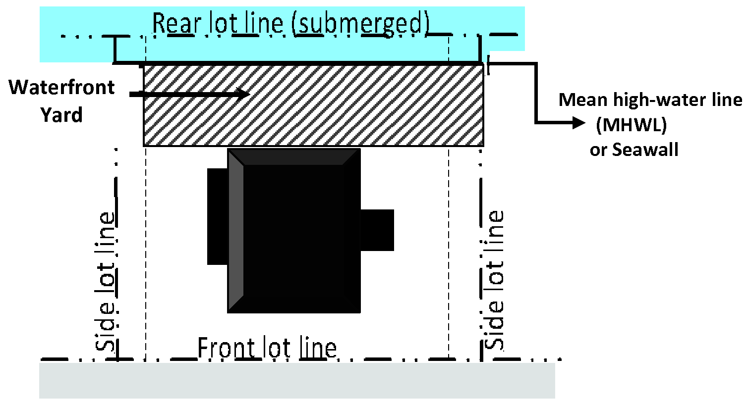
Zoning district. A specifically delineated area within which certain uses are permitted and others are prohibited; minimum dimensional requirements for yards and other open areas are required; and lot areas, building height limits and other requirements are established.
Zoning map. The official zoning map of the Town of Ponce Inlet, Florida, as amended.
(Ord. No. 2014-04, § 2(Exh. A), 7-17-2014; Ord. No. 2014-05, § 1, 7-17-2014; Ord. No. 2015-07, § 2(Exh. A), 11-19-2015; Ord. No. 2015-08, § 2(Exh. A), 11-19-2015; Ord. No.2015-04, § 3, 7-16-2015; Ord. No.2018-01, § 1, 1-18-2018; Ord. No.2018-07, § 2(Exh. A), 5-17-2018; Ord. No.2018-12, § 4, 9-20-2018;Ord. No. 2020-04, § 2(Exh. A), 1-23-2020; Ord. No. 2022-07, § 2, 11-17-2022; Ord. No. 2024-08, § 2(Exh. A), 11-21-2024)
SECTION 9.5. - ABBREVIATIONS AND ACRONYMS
AASHTO. American Association of State Highway and Transportation Officials
ADA. Americans with Disabilities Act
ADT. Average daily trips
ALF. Assisted living facility
BMP. Best management practice(s)
CCCL. Coastal Construction Control Line
CIP. Capital Improvement Program
DBH. Diameter at breast height
DRT. Development Review Team
Et Seq. Et sequentes (Latin): "and the following"
FAC. Florida Administrative Code
FAR. Floor area ratio
FBC. Florida Building Code
FBFM. Flood Boundary and Floodway Map
FDCF. Florida Department of Children and Families
FDEO. Florida Department of Economic Opportunity
FDEP. Florida Department of Environmental Protection
FDOT. Florida Department of Transportation
FHBM. Flood Hazard Boundary Map
FIRM. Flood Insurance Rate Map
FEMA. Federal Emergency Management Agency
F.S. Florida Statutes
HAP. Hazardous air pollutant
HUD. U.S. Department of Housing and Urban Development
LOD. Lighthouse Overlay District
LOS. Level of service
LUDC. Land Use and Development Code
MHW. Mean high water
MHWL. Mean high water line
MLW. Mean low water
MLWL. Mean low water line
NAVD. North American Vertical Datum
NHPA. National Historic Preservation Act
NFIP. National Flood Insurance Program
NGVD. National Geodetic Vertical Datum
ODP. Overall development plan
PCP. Permanent control point
PRM. Permanent reference monument
PUD. Planned Unit Development
PWD. Planned Waterfront Development
ROD. Riverfront Overlay District
SFHA. Special Flood Hazard Area
TIA. Traffic impact analysis
TIIF. Trustees for the Internal Improvement Trust Fund of the State of Florida
9.1.1 - Generally.
The LUDC shall be interpreted in favor of the objectives and purposes of the town, as expressed in the comprehensive plan and the LUDC. The LUDC does not limit or repeal other powers under state statutes.
9.1.2 - Responsibility for interpretation.
The director of planning and development shall have the duty and responsibility of interpreting the comprehensive plan and the LUDC. The director's responsibility to interpret is limited to the standards, regulations, and requirements of the LUDC. It does not include interpretation of any technical codes adopted by reference in the LUDC, or override the responsibilities given to any commission, board, or official named in the LUDC. The director shall be authorized to promulgate any rules and procedures found necessary for the implementation of the comprehensive plan and the LUDC.
9.1.3 - Computation of time.
The time required for any action in the LUDC is computed by excluding the first day and including the last day. If the last day is a Saturday, Sunday, or legal holiday, that day is excluded.
Example 1: "Within 30 days of the decision," means the 30 days after the decision is made, with day 1 being the day immediately following the date of the decision."
Example 2: "At least seven days prior to the hearing," means the seven days before the hearing, with day 1 being the day immediately preceding the hearing date (counting backward)."
A.
The word "year" means a calendar year, unless otherwise indicated.
B.
The word "day" means a working day, unless a calendar day is indicated.
9.1.4 - Delegation of authority.
A.
All actions or decisions required by any town official in the LUDC authorize that official to delegate the action to professional level staff, unless the code specifies otherwise.
B.
A reference to any town official includes that official's designee.
9.1.5 - Cross-references.
A.
References to any section or subsection refer to a location in the LUDC, unless otherwise stated.
B.
References to a "section" or "this section" refer to the entire two-level section, unless a more specific reference is stated. Example: A reference to "this section" means section 9.1 and all of the subordinate subsections (e.g., 9.1.1, 9.1.2, etc.)
9.1.6 - Gender.
Words signifying the masculine gender include the feminine and neuter.
9.1.7 - Number.
Words in the singular include the plural and words in the plural include the singular.
9.1.8 - Shall, may.
The word "shall" is mandatory; the word "may" is permissive.
9.1.9 - Written or "in writing"
The terms "written" or "in writing" include any representation of words, letters or figures, whether by printing or otherwise.
9.1.10 - Zoning district boundaries.
The following rules of interpretation are used to locate the zoning district boundaries shown on the official zoning map.
A.
Boundaries following streets. Boundaries following, or approximately following, the centerlines of streets are construed to follow those centerlines. If a street is vacated, the district boundary is construed to remain in its location. If ownership of the vacated street is divided other than at the center, the boundary is construed to move with the ownership.
B.
Boundaries following lot lines. Boundaries following, or approximately following, lot lines are construed to follow those lot lines.
C.
Boundaries following town limits. Boundaries following, or approximately following, town limits are construed to follow those town limits.
D.
Boundaries following water bodies. Boundaries following, or approximately following, the mean high-water line of a water body are construed to follow and move with that mean high-water line. Boundaries following, or approximately following, a bulkhead line are construed to follow the bulkhead line.
E.
Boundaries parallel to or extensions of above features. Boundaries apparently parallel to or extensions of the features indicated in subsections A through D are construed to be parallel to or an extension of those features, as the case may be.
F.
Other cases. Boundaries splitting existing lots in subdivisions and any other boundaries not determined by the above rules are determined by reference to the expressed distances on or the scale of the official zoning map. In unsubdivided property or where a zoning district boundary divides a lot, the boundary is located by using the scale that appears on the official zoning map unless the features are indicated by dimensions.
9.1.11 - Relationship of specific to general provisions.
More specific provisions of the LUDC apply in lieu of more general provisions when they are more lenient than or in conflict with the more specific provision.
9.1.12 - Words not defined.
Merriam-Webster's Collegiate Dictionary (latest edition) is used to define words that are not defined in the LUDC.