
Powder Springs City Zoning Code
ARTICLE 8
- LAND DEVELOPMENT REQUIREMENTS
Sec. 8-1. - Purpose.
This article includes requirements that apply to the land development process, including provisions for environmental protection, site grading and land disturbance activities, the installation of utilities and improvements; and land development activities.
Sec. 8-2. - Definitions.
Definitions in articles 9, 10, 11, and 12 of this development code apply to this article unless the context clearly indicates otherwise. In addition, the following terms are hereby defined:
Buffer, stream: A natural or enhanced vegetated area (established by this division), lying adjacent to the stream.
Fill: A portion of land surface to which soil or other solid material has been added; the depth above the original ground surface or an excavation.
Grading: Altering the shape of ground surfaces to a predetermined condition; this includes stripping, cutting, filling, stockpiling and shaping or any combination thereof and shall include the land in its cut or filled condition.
Impervious cover: Any manmade paved, hardened or structural surface regardless of material. Impervious cover includes but is not limited to rooftops, buildings, streets, roads, decks, swimming pools and any concrete or asphalt.
Land development: Any land change, including but not limited to clearing, grubbing, stripping, removal of vegetation, dredging, grading, excavating, transporting and filling of land, construction, paving and any other installation of impervious cover.
Land disturbing activity: Any activity which may result in soil erosion from water or wind and the movement of sediments into state waters or onto lands within the state, including, but not limited to, clearing, grubbing, stripping, removal of vegetation, dredging, grading, excavating, transporting and filling of land but not including agricultural practices or other activities exempt from the requirements of this article.
Riparian: Belonging or related to the bank of a river, stream, lake, pond or impoundment.
State waters: Any and all rivers, streams, creeks, branches, lakes, reservoirs, ponds, drainage systems, springs, wells, and other bodies of surface or subsurface water, natural or artificial, lying within or forming a part of the boundaries of Georgia which are not entirely confined and retained completely upon the property of a single individual, partnership, or corporation.
Stream: Any perennial or intermittent stream as defined and as shown on a United States Geological Survey quadrangle map; or any "state waters" as defined.
Stream, ephemeral: A stream that under normal circumstances has water flowing only during and for a short duration after precipitation events; that has the channel located above the ground-water table year round; for which ground water is not a source of water; and for which runoff from precipitation is the primary source of water flow.
Stream, intermittent: A stream with a well-defined channel that contains water for only part of the year (typically during winter and spring). The flow may be heavily supplemented by stormwater. When dry, an intermittent stream typically lacks the biological and hydrological characteristics commonly associated with continuous conveyances of water.
Stream, perennial: A stream with a well-defined channel that contains water year round during a year with normal rainfall. Groundwater is the primary source of water, but a perennial stream also carries stormwater. Perennial streams exhibit the typical biological, hydrological, and physical characteristics commonly associated with the continuous conveyance of water.
Stream bank: The confining cut of a stream channel and is usually identified as the point where the normal stream flow has wrested the vegetation. For non-trout waters, the normal stream flow is any stream flow that consists solely of base flow or consists of both base flow and direct runoff during any period of the year. Base flow results from groundwater that enters the stream channel through the soil. This includes spring flows into streams. Direct runoff is the water entering stream channels promptly after rainfalls or snow melts.
Stream channel: The portion of a watercourse that contains the base flow of the stream.
Stream protection area: The combined area of all required buffers and setbacks applicable to such stream.
Watershed: The land area that drains into a particular stream.
Wetlands: Freshwater areas that are inundated or saturated by surface or groundwater at a frequency and duration sufficient to support, and that under normal circumstances do support, a prevalence of vegetation typically adapted for life in saturated soil conditions. Wetlands generally include swamps, marshes, bogs and similar freshwater areas.
Sec. 8-3. - Exemptions.
This article shall not apply to the following activities:
(a)
Work consisting of the repair or maintenance of any lawful use of land that is zoned and approved for such use on or before the effective date of this article.
(b)
Existing development and ongoing land disturbance activities including but not limited to existing agriculture, silviculture, landscaping, gardening and lawn maintenance, except that new development or land disturbance activities on such properties will be subject to all applicable requirements of this article.
(c)
Any land development activity that is under construction or fully approved for development, as of the effective date of this article.
(d)
Land development activity that has not been submitted for approval, but that is part of a larger master development plan, such as for an office park or other phased development, that has been previously approved within 2 years of the effective date of this article.
Sec. 8-4. - Reference to requirements.
(a)
Site design review. Prior to, or concurrent with, submission of an application for development permit, site design review and approval shall be accomplished in accordance with the requirements of article 5, division II.
(b)
Subdivision. An application for a development permit approval may be processed independently or in conjunction with an application for preliminary plat approval, but a development permit shall not be issued for lands being subdivided and involving public streets, private streets, or any public improvement as defined, without the prior approval of a preliminary plat. See section 15-22 of this development code.
(c)
Tree and buffer protection. Prior to the commencement of grading, development, or land disturbance, areas outside the limits of approved clearing such as natural buffers, stream buffers, and tree protection zones shall be identified by survey stakes, flags, ribbons, or other appropriate markings. The community development director or designee shall inspect and approve all protective fencing prior to commencement of any clearing or grading activity. See section 12-24 of this development code for details relative to tree protection areas.
(d)
Grading. Grading shall be performed in accordance with the lines and grades indicated on the approved grading plan, in accordance with the requirements of division IV of this article.
(e)
Soil erosion and sedimentation control. All required soil erosion and sedimentation control measures and stormwater drainage facilities shall be installed in accordance with the approved plans consistent with the requirements of article 9 of this development code.
(f)
Stormwater management. Stormwater drainage facilities shall be installed in accordance with the approved stormwater management plan as specified in article 11 of this development code.
Sec. 8-11. - Official map of protected wetlands adopted.
(a)
The national wetlands inventory maps prepared by the U.S. Fish and Wildlife Service as they apply to the City of Powder Springs, are hereby adopted and incorporated herein by reference as the official map of protected wetlands in the city.
(b)
The map of protected wetlands may be amended by the City Council following the same procedures required for an amendment to the official zoning map.
Sec. 8-12. - Jurisdictional wetlands.
The National Wetlands Inventory maps adopted in this division do not necessarily represent the boundaries of jurisdictional wetlands within the City of Powder Springs and cannot serve as a substitute for a delineation of wetland boundaries by the U.S. Army Corps of Engineers, as required by Section 404 of the Clean Water Act, as amended. Any local government action under this article does not relieve the landowner from federal or state permitting requirements.
Sec. 8-13. - Alteration of wetlands.
Alteration or degradation of a jurisdictional wetland requires prior approval by the U.S. Army Corps of Engineers under Section 404 of the federal Clean Water Act, as amended.
Sec. 8-14. - Identification of wetlands on development plans.
(a)
It shall be the responsibility of the design professional preparing development plans, subdivision plats, and building plans to review the map of protected wetlands and to determine whether jurisdictional wetlands exist on the site to be developed, prior to land disturbance or development.
(b)
All protected wetlands and jurisdictional wetlands shall be identified and the boundaries thereof indicated on development plans, plats, and building plans where applicable.
Sec. 8-15. - Protection of wetlands.
(a)
Jurisdictional wetland. No development permit shall be issued by the city for development or land disturbance within a jurisdictional wetland, until a Section 404 permit or letter of permission is issued by the U.S. Army Corps of Engineers. Development or activities within a jurisdictional wetland shall be limited to those authorized by such permit or letter of permission.
(b)
Protected wetland. No development permit shall be issued by the city for development or land disturbance within a protected wetland, unless activities proposed are specifically identified on approved development plans. The community development director may limit activities within a protected wetland to: timber production and harvesting; wildlife and fisheries management; camping, hiking, hunting and fishing activities, or other authorized recreation; public wastewater treatment and natural water quality treatment or purification facilities; and/or other uses permitted under Section 404 of the Federal Clean Water Act. Sanitary landfills and hazardous waste receiving, treatment or disposal facilities are specifically prohibited within protected wetlands.
Sec. 8-21. - Findings.
Buffers adjacent to riparian areas provide numerous benefits including: protecting, restoring and maintaining the chemical, physical and biological integrity of streams and water resources; removing pollutants delivered in urban stormwater; reducing erosion and controlling sedimentation; protecting and stabilizing stream banks and riparian areas; providing for infiltration of stormwater runoff; maintaining base flow of streams; contributing organic matter that is a source of food and energy for the aquatic ecosystem; providing tree canopy to shade streams and riparian areas and promote desirable aquatic habitat; providing riparian wildlife habitat; furnishing scenic value and recreational opportunity; and providing opportunities for the protection and restoration of greenspace.
Sec. 8-22. - Exemptions and exceptions.
The following activities are exempt from the requirements of this division:
(a)
Activities for the purpose of building one of the following: a stream crossing by a driveway, transportation route or utility line; public water supply intake or public wastewater outfall structures; intrusions necessary to provide access to a property; public access facilities that must be on the water including boat ramps, docks, foot trails leading directly to the river, fishing platforms and overlooks; and unpaved foot trails and paths; activities to restore and enhance stream bank stability, vegetation, water quality and/or aquatic habitat, so long as native vegetation and bioengineering techniques are used.
(b)
Public sewer line easements paralleling the stream, except that all easements (permanent and construction) and land disturbance should be at least 25' from the top of the bank. This includes such impervious cover as is necessary for the operation and maintenance of the utility, including but not limited to manholes, vents and valve structures. This exemption shall not be construed as allowing the construction of roads, bike paths or other transportation routes in such easements, regardless of paving material, except for access for the uses specifically cited in this section.
(c)
Land development activities within a right-of-way on the effective date of this article.
(d)
Within an easement of any utility existing at the time this article takes effect or approved under the terms of this article, land disturbance activities and such impervious cover as is necessary for the operation and maintenance of the utility, including but not limited to manholes, vents, and valve structures.
(e)
Emergency work necessary to preserve life or property. However, when emergency work is performed under this section, the person performing it shall report such work to the community development director on the next business day after commencement of the work. The community development director after inspection of the emergency work may require the person performing emergency work to correct any impairment such emergency work may have caused to the water conveyance capacity, stability or water quality of the protection area.
(f)
Forestry and silviculture activities on land that is zoned for forestry, silvicultural or agricultural uses and are not incidental to other land development activity. If such activity results in land disturbance in the buffer that would otherwise be prohibited, then no other land disturbing activity other than normal forest management practices will be allowed on the entire property for 3 years after the end of the activities that intruded on the buffer.
Sec. 8-23. - Buffers and impervious setbacks.
All land development activity subject to this division shall meet the following requirements:
(a)
Buffer. An undisturbed natural vegetative buffer shall be maintained for 50', measured horizontally, on both banks (as applicable) of all streams, as measured from the top of the stream bank.
(b)
Impervious surface setback. An additional setback shall be maintained for 25', measured horizontally, beyond the undisturbed natural vegetative buffer, in which all impervious cover shall be prohibited. Grading, filling, and earthmoving shall be minimized within the setback.
(c)
Septic tanks and drain fields. No septic tanks or septic tank drain fields shall be permitted within the buffer or the setback required by this section.
All buffer and setback areas required by this section shall be shown on all final plats and development and building plans pertaining to the property.
Sec. 8-24. - Variances.
Upon application in accordance with article 14 of this development code, the governing body may vary the requirement of this section to maintain that portion of the requirement 50' buffer furthest from the stream bank, and the requirement to set back for impervious surfaces. Variances shall not be allowed by the city to that portion of the require stream buffer within 25' of the stream bank.
The following factors will be considered in determining whether to issue a variance:
(a)
The shape, size, topography, slope, soils, vegetation and other physical characteristics of the property;
(b)
The locations of all streams on the property, including along property boundaries;
(c)
The location and extent of the proposed buffer or setback intrusion;
(d)
Whether alternative designs are possible which require less intrusion or no intrusion;
(e)
The long-term and construction water-quality impacts of the proposed variance;
(f)
Whether issuance of the variance is at least as protective of natural resources and the environment; and
(g)
Whether the actions of the property owner have created conditions of a hardship on that property, in which case a variance should not be granted.
Sec. 8-25. - Relationship to other regulations.
This division is not intended to interfere with, abrogate or annul any other ordinance, rule or regulation, statute or other provision of law. The requirements of this division are considered minimum requirements, and where any provision of this development code imposes restrictions different from those imposed by any other ordinance, rule, regulation or other provision of law, whichever provisions are more restrictive or impose higher protective standards for human health or the environment shall be considered to take precedence.
Sec. 8-26. - Minimum requirements.
This division shall not be construed as preventing the establishment of wider and/or more restrictive buffers and setbacks as required under any other existing or future legislation. In addition, nothing in this division shall be construed as preventing the establishment of wider buffers for purposes of protecting greenspace, preserving habitat, or other goals that may not be specifically mandated by legislation.
Sec. 8-27. - Violations, enforcement and penalties.
Any action or inaction which violates the provisions of this article or the requirements of an approved stormwater management plan or permit, may be subject to the enforcement actions outlined in this Section. Any such action or inaction which is continuous with respect to time is deemed to be a public nuisance and may be abated by injunctive or other equitable relief. The imposition of any of the penalties described below shall not prevent such equitable relief. The imposition of any of the penalties described below shall not prevent such equitable relief.
(a)
Notice of violation. If the City of Powder Springs determines that an applicant or other responsible person has failed to comply with the terms and conditions of a permit, an approved stormwater management plan or the provisions of this article, it shall issue a written notice of violation to such applicant or other responsible person. Where a person is engaged in activity covered by this article without having first secured a permit therefor, the notice of violation shall be served on the owner or the responsible person in charge of the activity being conducted on the site.
The notice of violation shall contain:
(1)
The name and address of the owner or the applicant or the responsible person;
(2)
The address or other description of the site upon which the violation is occurring;
(3)
A statement specifying the nature of the violation;
(4)
A description of the remedial measures necessary to bring the action or inaction into compliance with the permit, the stormwater management plan or this article and the date for the completion of such remedial action;
(5)
A statement of the penalty or penalties that may be assessed against the person to whom the notice of violation is directed; and,
(6)
A statement that the determination of violation may be appealed to the City of Powder Springs by filing a written notice of appeal within 30 days after the notice of violation (except, that in the event the violation constitutes an immediate danger to public health or public safety, 24 hours' notice shall be sufficient).
(b)
Penalties In the event the remedial measures described in the notice of violation have not been completed by the date set forth for such completion in the notice of violation, any one or more of the following actions or penalties may be taken or assessed against the person to whom the notice of violation was directed. Before taking any of the following actions or imposing any of the following penalties, the City of Powder Springs shall first notify the applicant or other responsible person in writing of its intended action, and shall provide a reasonable opportunity, of not less than 10 days (except, that in the event the violation constitutes an immediate danger to public health or public safety, 24 hours' notice shall be sufficient) to cure such violation. In the event the applicant or other responsible person fails to cure such violation after such notice and cure period, the City of Powder Springs may take any one or more of the following actions or impose any one or more of the following penalties.
(1)
Stop work order - The City of Powder Springs may issue a stop work order which shall be served on the applicant or other responsible person. The stop work order shall remain in effect until the applicant or other responsible person has taken the remedial measures set forth in the notice of violation or has otherwise cured the violation or violations described therein, provided the stop work order may be withdrawn or modified to enable the applicant or other responsible person to take the necessary remedial measures to cure such violation or violations.
(2)
Withhold certificate of occupancy - The City of Powder Springs may refuse to issue a certificate of occupancy for the building or other improvements constructed or being constructed on the site until the applicant or other responsible person has taken the remedial measures set forth in the notice of violation or has otherwise cured the violations described therein.
(3)
Suspension, revocation or modification of permit - The City of Powder Springs may suspend, revoke or modify the permit authorizing the land development project. A suspended, revoked or modified permit may be reinstated after the applicant or other responsible person has taken the remedial measures set forth in the notice of violation or has otherwise cured the violations described therein, provided such permit may be reinstated [upon such conditions as the City of Powder Springs may deem necessary] to enable the applicant or other responsible person to take the necessary remedial measures to cure such violations.
(4)
Civil penalties - In the event the applicant or other responsible person fails to take the remedial measures set forth in the notice of violation or otherwise fails to cure the violations described therein within 10 days, or such greater period as the City of Powder Springs shall deem appropriate (except, that in the event the violation constitutes an immediate danger to public health or public safety, 24 hours' notice shall be sufficient) after the City of Powder Springs has taken one or more of the actions described above, the City of Powder Springs may impose a penalty not to exceed $1,000.00 (depending on the severity of the violation) for each day the violation remains unremedied after receipt of the notice of violation.
(5)
Criminal penalties - For intentional and flagrant violations of this article, the City of Powder Springs may issue a citation to the applicant or other responsible person, requiring such person to appear in City of Powder Springs court to answer charges for such violation. Upon conviction, such person shall be punished by a fine not to exceed $1,000.00 or imprisonment for 60 days or both. Each act of violation and each day upon which any violation shall occur shall constitute a separate offense.
Sec. 8-28. - Administrative appeal and judicial review.
(1)
Administrative appeal. Any person aggrieved by a decision or order of the City of Powder Springs, may appeal in writing within 30 calendar days after the issuance of such decision or order to the community development director or his/her designee of the City of Powder Springs and shall be entitled to a hearing before the Mayor and Council of the City of Powder Springs within 30 days of receipt of the written appeal.
(2)
Judicial review. Any person aggrieved by a decision or order of the City of Powder Springs, after exhausting all administrative remedies, shall have the right to appeal de novo to the Superior Court of Cobb County.
Sec. 8-31. - No clearing prior to development plan approval.
Grubbing, clearing, land disturbance, or development of property shall not take place until a development permit if required by this article has been approved and issued by the community development department; provided however, that the community development director may issue a clearing and grubbing permit only if activities are limited to the removal of vegetation and stumps and the placement of required tree protection measures and soil erosion and sedimentation control devices.
Sec. 8-32. - Clearing limits.
(a)
Clearing and land disturbing activities are subject to the limits of section 12-13 of this development code. Clearing for other than installation of infrastructure, right-of-way, or parking areas (for commercial, industrial or institutional developments) on a subsequent phase may not begin until 50 percent of the structures in the previous phase have been issued building permits and 25 percent of the structures in the previous phase have been issued certificates of occupancy.
(b)
No clearing or land disturbing activity shall occur beyond the limits of clearing shown on approved development plans.
(c)
If the development on the site stalls for a period of six months or more, the site be replanted per a plan approved by the community development director showing compliance with minimum tree canopy, street trees and buffer requirements.
(Ord. No. 2024-011, § 1(Exh.), 6-3-2024)
Sec. 8-33. - Maximum slopes.
(a)
The maximum slope for all cut slopes shall be 2:1 (two feet of run for every one foot of rise); provided, however, that when a cut is made in rock that requires blasting, the public works director may authorize a slope to exceed the maximum of 2:1.
(b)
The maximum slope for all fill slopes shall be 3:1.
(c)
The slope on cut or fill shall be uniform throughout for each section of cut or fill.
(d)
Guard rails shall be required at the top of cut or fill for any depth of cut or fill exceeding five feet.
(Ord. No. 2025-004, § 1 (Exh. B), 4-7-2025)
Sec. 8-34. - Borrow and fill.
Authorization must be obtained from the community development department to conduct soil and material borrowing and filling operations from one property to another. If the proposed grading requires removal of or filling in of 100 cubic yards or less, no permit shall be required. If more than 100 cubic yards are involved, a permit shall be required to be issued by the community development department.
Sec. 8-35. - Additional grading requirements.
(a)
Stumps and debris. Before grading is started, the area shall be first cleared of all stumps, roots, and brush. Debris that is removed shall be disposed of in a lawful manner. No debris of any kind shall be buried at the site of any construction or development. If any sections of the subgrade are composed of unsuitable or unstable material, such material shall be removed to the depth directed by the public works director and replaced with suitable, thoroughly compacted material.
(b)
Stockpile of topsoil. In all areas to be graded or filled, the developer shall stockpile the topsoil to be spread later in disturbed areas not paved.
(c)
Street rights-of-way. When streets are proposed, all street rights-of-way shall be graded to their full width by the developer so that pavement extensions or sidewalks, where required or if installed in the future, can be constructed on the same level plane.
(d)
Cover of disturbed areas. Immediately after grading and re-spreading of topsoil, all areas of disturbed soil shall be fertilized and seeded to achieve a suitable vegetative cover to prevent soil erosion. Areas of steep slopes shall be sodded or otherwise appropriately re-vegetated. When all construction is completed, all slopes and street shoulders shall be cleared of all rubbish and a suitable vegetative cover shall be established by sprigging, seeding, or sodding to prevent undue erosion. See also article 9 of this development code for specific soil erosion and sedimentation control requirements.
Sec. 8-41. - Approval required.
It shall be unlawful for any person to commence or proceed with land-disturbing activity until development plans are approved and a development permit is issued by the community development department.
Sec. 8-42. - Pre-application.
(a)
An applicant for a development permit is strongly encouraged to schedule a pre-application meeting with the community development department, which may also be attended by other review agencies as appropriate. Where other agencies cannot be represented at the pre-application meeting, a development permit applicant is encouraged to seek advance comments from internal and external agencies with jurisdiction over the development proposal.
(b)
The community development director is authorized to establish schedules and operational requirements for pre-application meetings. There shall be no fee charged for pre-application meetings.
(c)
A prospective development applicant is expected to incorporate all comments and recommendations provided at any pre-application meeting.
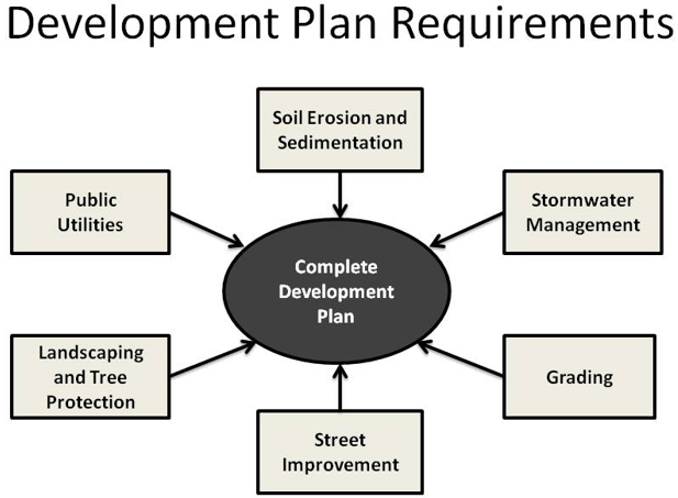
Sec. 8-43. - Development permit application requirements.
Development plans for a project shall conform in all respects with the requirements of this development code. Complete submittals shall consist of the following, as applicable:
(a)
Application form, fees, and plan sets. An application form as required by the community development director, fees as required per fee schedule approved by the City Council, and a number of full plan sets as specified by the community development director (5 unless otherwise specified).
(b)
Erosion and sedimentation control plan. See article 9 of this development code for specific requirements.
(c)
Grading plan. Grading plans shall identify existing and proposed topographic contour lines at the interval required for erosion and sedimentation control plans (see article 9). See division IV of this article for grading details.
(d)
Utilities plan. All utility construction plans within city or county right-of-way shall be reviewed and approved by the department of public works before construction begins.
(e)
Stormwater management plan. See article 11 of this development code for specific requirements.
(f)
Street improvement plan.
(g)
Landscaping, buffer and tree conservation plans. See article 12 of this development code for specific requirements.
Sec. 8-44. - Professional preparation of plans.
All development plans and supporting studies shall be prepared by or under the supervision of a professional engineer registered in the State, except that the landscaping, buffer and tree conservation plans are to be prepared by or under the supervision of a landscape architect registered in the state.
Sec. 8-45. - Development plan specifications.
Development plans shall contain the following (on one or more sheets):
(a)
Scale. Plans shall be clearly and legibly drawn at an engineering scale convenient to illustrate the details of the project. Sheet size shall not exceed 36" by 42". Plan and profile sheets, if any, shall have a horizontal scale of no less than one inch to 100' and a vertical scale of no less than one inch to 10'. The community development director and public works director may approve deviations from these required scales when appropriate.
(b)
Project boundary. Plans shall be based on the boundaries of a lot as shown on a recorded plat, or if not yet subdivided and recorded, on a boundary survey delineating the entirety of the property contained within the project. Boundary lines of the perimeter of the tract shall be indicated by a heavy line giving lengths to the nearest one-hundredth of a foot and bearings to the nearest second.
(c)
Adjoining property information. Provide all adjoining property owners, subdivision names, lot numbers, lot lines, and block letters, and zoning.
(d)
Project name and phase. The name of the project shall be indicated. If the project is located within a subdivision, the name of the subdivision, lot, and block number must also be shown. If the development project is part of a phased development or master-planned development, identify the unit number, division, phase, or stage of development.
(e)
Zoning and prior approvals. The existing zoning of the project site, and reference if applicable to conditions of zoning, variance, special use, or other permissions including case numbers and dates of approval.
(f)
Owner and developer. Name, address, and telephone number of the owner of record, and of the developer (if not the owner).
(g)
Professional contacts. Name, address, and telephone number of each professional firm associated with the Site Development Plans (engineer, landscape architect, etc.).
(h)
Map requisites. Date of survey, north point, and graphic scale, source of datum, date of plan drawing, and space for revision dates.
(i)
Use. Proposed use of the site, including gross square footage for each different use type or building.
(j)
Location references. Location, district, land lot(s) and parcel(s) acreage or area in square feet.
(k)
Location sketch. A location sketch locating the development in relation to the surrounding area with regard to well-known landmarks such as major thoroughfares or railroads. Sketches may be drawn in freehand and at a scale sufficient to show clearly the information required, but not less than one inch equal to 2,000'. U.S. Geological Survey maps may be used as a reference guide for the location sketch.
(l)
Buildings. Size, location, and elevation of all proposed buildings and existing buildings to remain or to be demolished, and minimum required building setback lines, the location parking and loading areas, driveways, curb cuts and where required designated fire lanes. Each building shall be identified with a number or letter.
(m)
Topography. Existing contour lines based on sea level datum shall be drawn at intervals of not more than 2' and shall include the entire site and all abutting public streets. Contour lines shall be based on field surveys or photogrammetric methods from aerial photographs. The basis for the topographic contour shown shall be specified and dated. Grading plans shall show proposed contours.
(n)
Natural features within the proposed development. These include drainage channels, bodies of water, and other known significant features such as extensive exposed rock. On all water courses the direction of flow shall be indicated. The 100-year floodplain shall be delineated and the source of the depicted floodplain information shall be indicated (i.e., reference to map panel numbers and dates). The acreage or area in square feet within the floodplain shall be indicated.
(o)
Man-made features. These include those features existing within and adjacent to the proposed development including existing right-of-way width and pavement widths of adjoining streets, street names, the location and dimensions of existing bridges, easements (all purposes), culverts and other drainage facilities, water, sewer, and other existing utility lines and structures, the names of jurisdiction lines; existing structures on the site and their disposition, and other appropriate built-environment information.
(p)
Driveways. Individual driveways shall conform to the requirements of article 6, division II of this development code.
(q)
Trees, buffers, landscaping. If buffers or other landscaping or screening treatments are required, show the location, size, and type (natural or planted) on the plans conforming to the requirements of article 12 of this development code, as applicable.
(r)
Certificate of approval. Each plan set shall include the following certificate printed or stamped thereon:
"All requirements of the Powder Springs Unified Development Code relative to the preparation and submission of a development permit application having been fulfilled, and said application and all supporting plans and data having been reviewed and approved by all affected departments as required under their respective and applicable regulations, approval of this development plan is hereby granted.
(s)
Additional information. Such additional information as may be reasonably required to permit an adequate evaluation of the project.
Sec. 8-46. - Incomplete application.
The community development department may elect not to process an incomplete development permit applications and may refuse to process such incomplete application.
Sec. 8-47. - Encroachment permits.
The applicant for a development permit is responsible for obtaining any and all permits and/or encroachments necessary to construct his/her development to include but not limited to permits from the following entities: Cobb County; Georgia DOT; Colonial Pipeline; Railroad; and power, telephone, cable, gas, or any other utility that may require permitting or encroachments. A development permit will not be issued if such permits, if required, are not obtained.
Sec. 8-48. - Distribution of plans for review.
Upon receipt of a completed application for development permit, the community development department shall submit the application and a plan set to internal and external review agencies, as determined by the community development department to have jurisdiction. Such agencies may include but are not limited to the following:
(a)
The City of Powder Springs public works director.
(b)
The Georgia Department of Transportation, in cases where access is proposed or land is divided along a state route, and/or the Cobb County Department of Transportation, in cases where county roads are proposed to be accessed by the development project.
(c)
The Natural Resources Conservation Service, or the Soil and Water Conservation Commission or regional representative, and/or the Environmental Protection Division of the Georgia Department of Natural Resources.
(d)
The U.S. Army Corps of Engineers, in cases where a jurisdictional wetland is shown on the site to be developed.
(e)
Public safety agencies, including the E-911, police, and fire department, where appropriate.
(f)
Others, as may be determined appropriate by the community development director.
Sec. 8-49. - Development permit application processing.
Within one week of receiving a development plan application, the community development department shall confirm completeness and if complete, distribute the application to internal and external review agencies, as appropriate.
(a)
A period of 3 calendar weeks shall be allotted for the distribution and collection of comments from all applicable review agencies.
(b)
Upon the receipt of all internal and external review agency comments, the department shall determine whether to approve, disapprove, or request revisions of the application. Decisions on development permits shall be issued by the community development department within 40 calendar days:
Sec. 8-50. - Criteria for decisions on development permit applications.
The community development department shall review and act on the development permit after considering the following criteria, which shall not be limiting:
(a)
Development code and zoning conditions. Development plans must be consistent with all parts of this development code, as applicable, and any conditions of zoning, special use, or variance approval, where applicable.
(b)
Previously approved plats and plans. When property to be developed is included on an approved preliminary plat, master plan, or concept/sketch plan, development plans shall be in substantial accordance with said plat or plan as determined by the community development director. Significant departures from any such requirements may require the resubmission of preliminary plat, master plan, or concept/sketch plan previously approved, as determined by the community development director.
(c)
Development code requirements. The community development department may deny the development permit application in cases where the proposed development does not meet the requirements of this development code or the comments of any other internal or external agency with jurisdiction to review the development permit application.
(d)
Site design review. The community development department may deny the development permit application when the permit application is submitted concurrently with an application for site design review as specified in article 5 of this development code, and the department may deny such application if inconsistent with a previously approved site design approval by the department.
Sec. 8-51. - Revisions.
(a)
Development plan applications shall be revised and resubmitted to accommodate the consolidated comments by review agencies as issued to the applicant by the community development director.
(b)
Plan drawings that are submitted for revision must specifically identify those areas that are to be considered for review and approval. The revisions shall be noted in tabular form in the revision block on the plan drawings.
(c)
After issuance of a development permit, if changes are desired or made necessary as a result of field conditions, the design engineer must contact the community development department to coordinate the review and approval of the requested revision.
Sec. 8-52. - Pre-development inspection.
Prior to grubbing, clearing or development of the property or any portion included under the development permit, an inspection by the city shall be required for soil erosion and sedimentation control measures and the installation of protective devices for undisturbed areas. The owner shall be responsible for correcting any deficiencies identified during the inspections process prior to commencing with development activities.
Sec. 8-53. - Duration of development permit.
A development permit shall expire 12 consecutive calendar months after issuance unless development activity as authorized by the permit is initiated within the 12-month period.
Sec. 8-54. - Extension of expiring development permit.
The director of community development may approve one extension of development permit validity not exceeding 3 consecutive calendar months within which time development activity must commence or the permit shall expire. Said extension shall be applied for within the first 12 consecutive calendar months after the permit's issuance.
Sec. 8-61. - Street access.
(a)
Every development and every lot within a subdivision shall have access to a publicly approved street meeting the requirements of this Article (see also article 6 of this development code).
(b)
No subdivision or development shall be designed in a way that would completely eliminate street access to adjoining parcels of land.
(c)
Access onto a state road shall meet existing Georgia Department of Transportation requirements. The entrance must be paved. A copy of the Georgia Department of Transportation permit shall be submitted to the community development director before the plans can be approved.
Sec. 8-62. - New public streets.
(a)
Standards. Public streets contained wholly within a subdivision or land development shall be improved to the full standards contained in this article and article 21 of this development code (See standard detail 400.01 for residential streets and standard detail 400.02 for industrial/commercial streets).
(b)
Separation. No new street that intersects a State or U.S. numbered highway shall be approved unless there is maintained a separation of at least 800' from any other street. The Georgia Department of Transportation may require a greater separation between streets intersecting a State or U.S. numbered highway. Other, local, adjoining street intersections shall be spaced at least 250' apart measured from edge of right-of-way to edge of opposing right-of-way.
(c)
Continuation of existing streets. When a new street is proposed within a development or subdivision, the development or subdivision shall provide for the continuation or projection of any existing street adjoining the development or subdivision at the same or greater right-of-way and pavement width. Where, in the opinion of the community development director, it is necessary to provide for street access to adjoining property, proposed streets shall be extended by dedication of right-of-way to the boundary of such property through the development.
(d)
Street jogs. Street jogs with centerline offsets of less than 125' on interior subdivision streets and 200' on existing streets shall not be allowed.
(e)
Intersection angles. All streets shall intersect at no less than 60 degrees, and as near a right angle as possible. The angle of intersection is to be measured at the intersection of the street centerlines. Such intersecting streets shall provide an uninterrupted line of sight from the center point of the intersection for not less than the minimum sight distance required in accordance with this development code.
(f)
Intersection miter. Intersecting street right-of-way lines shall parallel the back of curb of the roadway, and shall be mitered 20' along both streets from the point of the right-of-way lines projected to their intersection.
(g)
Curb radii. Curb lines at street intersections shall have a radius of curvature of not less than 15'.
(h)
Planned streets. When a future street or road, as proposed in the comprehensive plan, adjoins or traverses a subdivision or development project, the future right-of-way shall be platted as part of the subdivision or development project. No development will be allowed within the platted future right-of-way except for drives and landscaping, and the platted future right-of-way is to be treated as a lot line for the provision of all setback lines as required by this article. The developer will be contractually bound to the City of Powder Springs to sell this strip of land to the city at a future date, for the amount stated in the tax digest unless otherwise agreed to by both parties. A right-of-way agreement shall be executed before community development director approves the subdivision or development project.
Sec. 8-63. - Minimum street right-of-way and pavement width.
All State or U.S. numbered highways shall meet all design requirements of and be approved by the Georgia Department of Transportation. All other roads shall meet the minimum street right-of-way and pavement width requirements of Table 8-1. The community development director shall determine which street classification applies in particular instances, based on the city's adopted comprehensive plan, or in the absence of specific functional classifications in the comprehensive plan, based on the city, county, or regional transportation plan.
Table 8-1
Minimum Required Street Right-of-Way and Pavement Widths
(Excludes State and U.S. Numbered Highways)
*Additional five feet of right-of-way required on each side where the Comprehensive Plan envisions future trails.
In residential subdivisions or land developments, streets that serve 100 dwelling units or more shall be improved to or exceed "minor collector" street standards, while those serving fewer than 100 dwelling units shall be improved to or exceed "local" street standards.
(Ord. No. 2023-014, § 1(Exh. A), 9-18-2023)
Sec. 8-64. - Dedication of right-of-way for existing substandard streets.
Subdivisions or developments that adjoin an existing street that does not meet the right-of-way width required by this development code for said street as classified, shall dedicate up to one-half of the right-of-way needed to meet the minimum right-of-way width required for the street along the entire property frontage. If any part of a subdivision or land development fronts on both sides of an existing street, all of the right-of-way needed for the existing street to meet the right-of-way standards of this development code for the street shall be dedicated along the entire property frontage.
Sec. 8-65. - Improvement of existing streets.
(a)
Existing streets that adjoin a major subdivision or land development shall be improved to the minimum standards of this development code from the centerline of the street along the development's or major subdivision's frontage. Such required improvements specifically include widening of the street from the centerline to the pavement width specified for the street as classified, and the installation of curb and gutter and, if required, sidewalk, along the entire property frontage abutting the existing street.
(b)
Proposed subdivisions or nonresidential developments accessing an existing city street that has less than 16' of pavement width shall be required to upgrade the city street to 18' of pavement, with 2 2' shoulders, adequate drainage ditches (if required), and obtain the necessary right-of-way to accomplish these improvements. The city street shall be improved by the subdivider or developer the length of the road required to reach a city street or county road that meets standards of this development code.
(c)
Any existing street adjoining a major subdivision or land development that is subject to improvement as part of an approved land development permit (or provides access to the subject property/permit) shall be included in any guarantee required by the community development director in accordance with article 15, division VI, subdivision improvement guarantees of this Unified Development Code.
(Ord. No. 2023-014, § 1(Exh. A), 9-18-2023)
Sec. 8-66. - Improvement of development entrances - residential subdivisions.
(a)
Residential subdivisions not exceeding 20 lots whose entrance is on an unclassified, local or minor collector city or county road shall install offset radii and 50' tapers as shown in standard detail.
(b)
All other residential subdivisions shall construct a full deceleration lane to conform to standard detail.
(c)
Residential subdivisions exceeding 200 lots may be required to install a center turn lane and longer acceleration/deceleration lanes if the public works director determines the existing city or county road warrants it.
(d)
In cases involving rock cuts, deep fills or cuts, proximity to floodplain, etc., the requirements of pavement widening for full acceleration/deceleration lanes may be modified or waived by the public works director following accepted engineering practice.
Sec. 8-67. - Improvement of commercial/industrial development entrances.
(a)
A full deceleration lane shall be installed per standard detail unless determined to be unwarranted by the public works director.
(b)
If the public works director determines that the project's size warrants a center turn lane and longer acceleration/deceleration lanes, then such improvements will be required.
(c)
In cases involving rock cuts, deep fills or cuts, proximity to floodplain, etc., the requirements of pavement widening for full acceleration/deceleration lanes may be modified or waived by the public works director following accepted engineering practice.
Sec. 8-68. - Private streets.
(a)
Private streets shall only be permitted if approved by the Mayor and City Council, and in all cases shall meet all requirements and standards that apply to public streets.
(b)
Streets and associated storm drainage serving multi-family residential development consisting of 12 or more units shall be constructed to public local residential street standards as established by this development code.
(c)
See sections 15-75 and 15-76 for requirements for subdivisions involving private streets.
(d)
All property served by a private street shall be subject to restrictive covenants running with the land that provide and acknowledge that the street is private and not maintained by the city and that maintenance of the street is the responsibility of the owners of such property or private association of the owners.
(e)
Each private street shall be denoted as "private" on the street name sign.
(f)
Any gate placed across a private street that limits access to a subdivision or development shall provide for unimpeded access by emergency vehicles, governmental vehicles on official business, and public and private delivery services including the U.S. Postal Service. Accessibility to such gated communities shall comply with all standards and requirements of the city for access activation, and shall be of breakaway or other construction acceptable to the city.
Sec. 8-69. - Grade and design speed.
(a)
All streets shall have a minimum grade of one percent. Minimum grade on cul-de-sacs should be one and one-half percent to maintain one percent in curb line.
(b)
Minimum design speeds and maximum grades for proposed streets by street classification shall be as specified in Table 8-2 (maximum grade for streets without curb and gutter shall be 14%).
Table 8-2
Minimum Design Speed and Maximum Grade
for Streets by Street Classification
Sec. 8-70. - Cul-de-sacs and dead-end streets.
(a)
A cul-de-sac shall be no more than 600' long unless necessitated by topographic or other conditions and approved by the community development director. Cul-de-sacs shall terminate in a circular turnaround having a minimum right-of-way of, for residential streets at least 100' in diameter, and a paved turnaround with a minimum outside diameter of 80' (see standard detail 400.03 in article 21 of this development code). On commercial and industrial streets, cul-de-sacs shall have a right-of-way diameter no less than 160', and a pavement diameter of 124' (see standard detail 400.04 in article 21 of this development code).
(b)
A dead-end street other than a cul-de-sac shall not be allowed except as a temporary stage of construction of a street that is intended to be extended in a later stage of construction. Such a temporary dead-end street shall be provided with a temporary turn-around having a roadway radius of 44', except that alleys, if permitted shall have a turnaround radius of 40'.
Sec. 8-71. - Alleys.
(a)
Alleys may be provided in residential blocks where the subdivider produces evidence satisfactory to the community development director of the need for alleys.
(b)
Where an alley has been specifically authorized or required, the roadbed width shall be no less than 20', containing a paved roadway of no less than 16' exclusive of gutters.
Sec. 8-72. - Half streets prohibited.
Half streets are prohibited. Whenever a street is planned adjacent to the proposed subdivision or development tract boundary, the entire street right-of-way shall be platted within the proposed subdivision or development.
Sec. 8-73. - Split-level streets and one-way streets.
One-way streets and split streets will be allowed, subject to the approval of the community development director, when topographic conditions are such that alternatives to the typical street construction would be more desirable, or the shape and size of the parcel could be more efficiently developed.
Sec. 8-74. - Curb and gutter.
Curb and gutter are required on all new streets and new construction on existing streets, including acceleration and deceleration lanes and travel lane widenings. See article 21 for details.
Sec. 8-75. - Sidewalks.
(a)
Sidewalks are required to be installed by the developer at the time of development along each side of any public or private street within or adjacent to the development.
(b)
Sidewalks shall be located as shown on standard detail for residential streets. On arterial and major collectors, the sidewalk shall be located along but not less than one foot from the right-of-way line.
(c)
Concrete sidewalks shall be a minimum of 5' wide and 4" thick. Concrete shall be 2,500 psi at 28 days' strength. Sidewalks shall be backfilled and landscaped.
Sec. 8-76. - Street lighting.
(a)
Required. Any person or entity developing a new subdivision project constructing new streets to be dedicated to the City of Powder Springs or utilizing existing city or county roadways (or combination thereof) shall be required to provide streetlights which conform to the standards included in this section. In order to ensure adequate illumination of public rights-of-way and promote safety and security, the American National Standard Practice for Roadway Lighting of the Illuminating Engineering Society, as approved by the American National Standards Institute (1983), and as from time to time amended, is hereby adopted as the standard for the installation and operation of lighting in the city, with the following exceptions:
(1)
Lighting fixtures installed within the public rights-of-way to be operated for the purpose of street illumination shall comply with the following standards. The minimum average horizontal footcandle illumination (AHFI) level by roadway classification shall be:
The uniformity of illumination shall be such that the point of lowest illumination shall have at least one-third of the average horizontal footcandle required illumination level, except that on local or residential streets it may be not less than one-sixth of this average. The fixtures shall be mounted a minimum of 25 feet above the ground, and each fixture shall have appropriate arm length to illuminate the street.
(b)
Plan. The subdivider or developer shall submit a street light layout prepared by the utility company which will provide the lighting service showing the exact location of street lights within the subdivision. The lighting layout must be approved by the director of infrastructure and development, or his/her designee.
(c)
Costs. The subdivider or developer must pay for all costs to the power company for pole fixtures, and other related items or materials necessary for the installation. Evidence of such completed payment shall be provided to the community development director at the time of final plat submittal. The subdivider or developer shall bear the costs for all monthly street light charges until all residential structures have been completed. At such time of completion, the subdivider or developer shall provide written notification to the City of Powder Springs (via its community development director) requesting that the billing be transferred to the City of Powder Springs. Any such request for transfer of billing shall be presented to and approved by the mayor and council.
(Ord. No. 2023-014, § 1(Exh. A), 9-18-2023)
Sec. 8-77. - Street names.
(a)
Proposed public or private streets, which are extensions of, or in alignment with, existing or other proposed streets shall have the same name.
(b)
Street names shall not duplicate or be phonetically similar to existing street names. In no case shall the name for a proposed street duplicate existing street names in Cobb County or any of its cities, irrespective of the use of a suffix such as: street, avenue, boulevard, road, pike, drive, way, place, court or other derivatives.
(c)
All street names shall have a maximum of 13 letters or spaces, including the 2-letter suffix.
(d)
All street names are subject to the approval of the County Emergency Services Department and the community development director, either of whom may reject a proposed road name for good cause shown.
Sec. 8-78. - Street name signs, traffic signs and street striping.
(a)
Public streets. Street name signs, stop bars, and traffic control signs on public streets or streets to be dedicated to the city shall be installed by the city at the developer's expense. Street name signs of a type approved by the city shall be placed at all intersections.
(b)
Private streets. On private streets and drives, street name signs, stop bars, and traffic control signs shall be installed by the developer at the developer's expense. The city may require a street name sign for a private street to be a different color than the standard color for a public street name sign.
(c)
Stop signs. Stop signs shall be located from the sign's edge 6' off the back of curb or edge of gravel at the beginning of the intersection radius. The sign shall be located on the right side of the intersection. The bottom of the sign shall be at least 5' above the edge of pavement or back-of-curb. This standard applies to typical residential interior street intersections. In a private development, the design professional shall show the location of all required traffic signs on the street plans. Stop signs shall be sized so that their overall dimensions are 30" by 30".
(d)
Reference to manual. All traffic control signs and street striping shall be installed according to standards contained in the Manual on Uniform Traffic Control Devices, latest edition, published by the Federal Highway Administration of the U.S. Department of Transportation.
Sec. 8-79. - Sight visibility at street and driveway intersections.
(a)
A sight visibility triangle shall be located at every street intersection with another street or a private driveway.
(b)
At public street intersections, the 2 intersecting street right-of-way lines and a line connecting the right-of-way lines at the points indicated in the Table 8-3 delineates the sight visibility triangle. The connecting points shall be measured from the right-of-way lines extended to their point of intersection.
Table 8-3
Minimum Sight Distance at Intersections
(See Illustration)
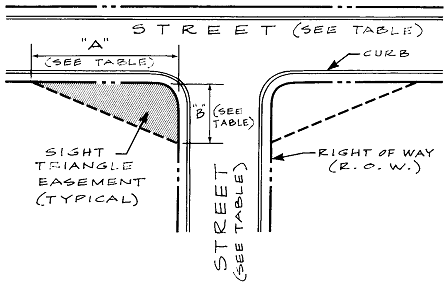
(c)
At private driveway intersections with public streets, the edge of the driveway's pavement or back of curb will be used for the sight triangle measurements along the driveway.
(d)
The planting of trees or other vegetation or the location of structures exceeding 30" in height that would obstruct the clear sight across the sight visibility triangle shall be prohibited.
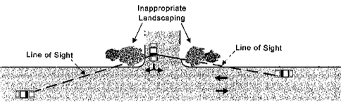
Source: Stover, Vergil G., and Frank J. Koepke. 2002. Transportation and Land Development (2ndEd.). Washington, DC: Institute of Transportation Engineers. Figure 7-45, p. 7-54.
Sec. 8-80. - Accessibility for fire fighting equipment.
(a)
Reasonable accessibility shall be provided to and around all buildings for fire fighting equipment, including ladder trucks on multiple-story projects. A minimum of 20' on all sides and a radius of 50' at corners shall be considered reasonable. Accessibility for fire fighting equipment shall be maintained throughout all stages of construction and occupancy.
(b)
Minimum widths of access driveways excluding parking, shall be 20'. Minimum turning radii shall be 32'.
(c)
Where the number of dwelling units in a project exceeds 100, there shall be 2 entrances to the project where road frontage is adequate for 2 entrances.
Sec. 8-91. - Utility easements.
Easements in connection public and private utilities serving subdivisions or developments shall be provided as required by the community development director, the public works director, and public or private utility providers.
Sec. 8-92. - Drainage easements.
(a)
Drainage easements shall be provided as required by this section and as may be required by the public works director.
(b)
A publicly dedicated drainage easement shall be provided along any perennial stream or water impoundment within a development located outside a street right-of-way. The easement shall be substantially centered on the watercourse or surround the high water line of the impoundment and shall be of such width as to include all stream buffers required by this development code and for adequate access by maintenance equipment.
(c)
A publicly dedicated drainage easement shall be provided along any drainage channel or drainage pipe located outside a street right-of-way. All easements shall be no less than 20' wide. A drainage easement may be combined with a sanitary sewer easement, but in such instance the easement shall be a minimum width of 30'.
(d)
All drainage easements shall be cleared and opened for improvement at the time of development to control surface water run-off. Run-off slopes and side slopes shall be specified by the developer's engineer according to good engineering practices, subject to the approval of the public works director.
(e)
Drainage easements off the street right-of-way shall be clearly defined on the final plat and described within the deed of individual property owners affected, and such property owner shall keep the easement free of obstructions and maintain that part of the easement within the property owner's boundary line so that free and maximum flow is maintained at all times.
Sec. 8-93. - Location of above-ground utilities.
Where feasible, all utilities shall be located underground. In cases where they are not, telephone poles, street light poles, telephone junction boxes and other public or private utility structures placed above ground within a street right-of-way must be at least 8' back from the back of the street curb (or edge of pavement) and one foot back from the edge of any sidewalk, whichever is farthermost from the roadway.
Sec. 8-94. - Underground utilities.
Utilities placed underground shall be placed within the right-of-way as approved by the public works director on construction drawings for the project.
Sec. 8-95. - Storm drainage.
(a)
An adequate drainage system, including necessary ditches, pipes, culverts, drains, inlets, bridges, etc., shall be provided for the proper drainage of all surface water.
(b)
All persons proposing development or construction in the city shall prepare a stormwater management plan, unless specifically exempted from compliance. See article 10 of this development code for requirements.
(c)
No final subdivision plat shall be approved and no development or building permit shall be issued until and unless the stormwater management plan, if required, has been reviewed and approved by the public works director.
(d)
Permanent detention facilities will be required, and they shall be designed in accordance with the specifications of this development code. See division IV of article 21 for specifications.
(e)
In a residential subdivision, the stormwater detention facilities shall be located on a separate lot, which is owned by a homeowner's association that is responsible for its maintenance and proper operation.
Sec. 8-96. - Storm drainage plan exceptions.
The following development activities are exempt from the provisions of this Section and the requirement of providing a stormwater management plan (see also article 11):
(a)
Agricultural land management.
(b)
Additions or modifications to existing single-family detached dwellings.
(c)
Developments with a total land area of 1.1 acres or less.
(d)
Residential development consisting of single-family houses, each on a lot of 2 acres or greater.
Sec. 8-97. - Public water.
(a)
Public water service shall be provided to every lot in a subdivision and to every development for both domestic use and fire protection if public water is available or programmed to be available within 1,000' of the subdivision or development (or 100' of an individual single-family residential lot not in a subdivision). Water mains shall be connected to the existing public water system and extended past each lot.
(b)
Developers are required to extend all mains along their entire property frontage if the existing main is not adjacent to the proposed development. The size of the extension will be at least the size of the existing main and may be larger according to the city. The oversizing may be eligible for reimbursement under agreement. If eligible, the difference in cost for lines larger than those required to serve the development will be paid by the city. If an existing main must be extended to serve a particular development, the developer will be required to pay all the initial costs. If the main extension would serve other developments within a 3-year period the city may negotiate with the initial developer for pro rata share reimbursement from future developers who wish to tie on during the 3-year period. This 3-year period would begin upon completion of the extension and acceptance by the city for perpetual maintenance.
(c)
Any single-family or multifamily dwelling, commercial or industrial establishment shall be connected to a public water supply approved by the city. Connection shall be at the cost of the property owner.
(d)
Fire hydrants shall be required to be installed along the streets in every subdivision and within every development project. Hydrants shall be located in accordance with article 21 of this development code.
(e)
A contractor approved by the city shall install all elements of the water system, including mains, valves and hydrants at the developer's expense.
(f)
The city may participate in sharing the costs of construction and installation to the extent that pipe sizes are needed in excess of that size required to exclusively serve the subdivision or development.
(g)
If a permit from the Georgia Department of Natural Resources is required for construction of a water system, all department requirements for design and material and construction specifications must be met to secure a permit.
Sec. 8-98. - Sanitary sewer.
(a)
Every lot in a subdivision and every development shall be connected to a public sanitary sewerage system unless on-site disposal is allowed by this Code and the Cobb County Health Department.
(b)
Any single-family or multifamily dwelling, institutional, commercial or industrial establishment shall be connected to public sewer when sewerage lines are available for connection. Connection shall be at the cost of the property owner.
(c)
Sewerage shall be considered available to an existing single-family dwelling or other connection when the dwelling or building can be connected by gravity flow to a line in any public right-of-way or easement that passes the property at any point.
(d)
Sewerage shall be considered available to any new single-family dwelling when the dwelling can be connected by the installation of 300 linear feet of gravity flow line from the nearest point of the property.
(e)
Sewerage shall be considered available to any new subdivision when trunk sewers have been extended into the drainage basin.
(f)
Sewerage shall also be considered available when trunk sewers are constructed under a current funding program. Trunk sewers are those sewers recognized in the facilities plan, or other planning documents of the city. When trunk sewers are to be funded under future bond programs, sewerage will not be considered available.
(g)
To determine the availability of sewerage to any multi-family dwelling, commercial or industrial tract the sewage effluent for the development will be converted to its equivalent number of single-family dwellings. For comparison purposes, a single-family dwelling generates an effluent of 400 gallons per day of sewage.
(h)
Sewer lines shall be connected to an existing sanitary sewerage system and extended past each lot.
(i)
Every component of the sanitary sewer system, including mains, lift stations, outfalls, and laterals, shall be installed at the developer's expense by a contractor approved by the jurisdiction that owns the sanitary sewerage system.
Sec. 8-99. - Dry sewerage available.
(a)
In cases where the city is to expend bond funds within a drainage basin in 2 years but said sewers are not available at present, the developer will be required to install dry lines to serve any structure to be built in the development. These lines will collect at a single point at the property line at the lowest point on the property or at a point designated by the engineer.
(b)
The installation of dry lines does not in any way relieve the requirements of the Cobb County Health Department for approving septic tanks in the development.
(c)
No dry sewers shall be used until such time as trunk sewers are constructed to an acceptable treatment facility. No pumping and hauling of sewage is allowed. Septic tanks placed on the lots shall be located at a point to facilitate future connection of the home to the tap provided.
Sec. 8-100. - Sewerage not available.
(a)
If sewerage is not available nor shall be available, a 20' permanent and 60' construction sanitary sewer easement shall be shown on the plans and dedicated to the City of Powder Springs for future use, in those areas where a proposed subdivision is adjacent to a creek or branch whose drainage area is 200 acres or greater. The City of Powder Springs may at its option require additional easements.
(b)
Minimum easement widths to be dedicated are 20' for permanent easements and 60' for construction easements, with the construction easement centered on the permanent easement. Also, in the event that a trunk or interceptor greater than 15" is expected to pass through the development, the construction easement width shall be increased to the amount required for construction of the expected sewer. All easements are to be checked in the field and must be adequate for the purpose they are dedicated. Also, consideration must be given for expected building locations and the easement shall be located for the least possibility of conflict before the sewer may be constructed. No structures shall be built on dedicated easements, and the city will not be responsible for the removal of fences that are placed on dedicated easements in the event the sewer is constructed. Septic tanks in these type developments shall be placed in a location to facilitate tie-on of structure to the sewer.
Sec. 8-101. - Sewer types.
(a)
Building sewers. Building sewers are used to convey wastewater from the buildings to lateral sewers, or any other sewer except another building sewer. These sewers are privately funded. Typically, these lines extend from the building to the property line where they tie into a lateral system.
(b)
Lateral sewers. Lateral sewers form the first element of the public wastewater collection system and are usually in streets, rights-of-way, or special easements. They are used to collect wastewater from building sewers and convey it to a main sewer. The minimum lateral sewer size is 6". In new subdivisions these sewers are privately funded.
(c)
Main sewers. Main sewers are used to convey wastewater from one or more lateral sewers to trunk sewers or to intercepting sewers. These sewers are a minimum of 8" in diameter and can extend beyond the property boundaries of subdivisions.
(d)
Trunk sewers. Trunk sewers are large sewers that are used to convey wastewater from main sewers to treatment or other disposal facilities or to large intercepting sewers.
(e)
Intercepting sewers. Intercepting sewers are large sewers that are used to intercept a number of main or trunk sewers and convey the wastewater to treatment or other disposal facilities.
Sec. 8-102. - Developer agreements for sewerage.
(a)
The City of Powder Springs recognizes that major sewer extensions are costly but must be made by private developers to make some developments workable. It is the intent of the City of Powder Springs to indirectly assist in these major extensions of sewer lines by adopting the policy described in this section.
(b)
A major sewer extension shall be defined as a sewer line extension by a private developer that costs in excess of $100,000.00 and is not located within a new residential subdivision.
(c)
The private developer will be eligible to recover, over a maximum of 3 years from the date the sewer line is accepted by the city, up to 75% of the cost of the sewer extension. This recovery shall be as follows: The city will collect the tap fees for all services that connect into the collection lines paid for by the developer as provided for in above. For a period for 3 years, the city will keep 25% of these fees and will remit 75% of the fees collected to the private developer up to a maximum of 75% of his total recoverable cost. After a period of 3 years or after a developer has recovered 75% of the allowable cost, the city shall retain 100% of the sewer tap fees.