
Preston City Zoning Code
CHAPTER 17
02 GENERAL PROVISIONS
17.02.010 Title
The regulations contained herein shall be known as the ZONING CODE OF PRESTON, IDAHO, and may hereafter be referred to as "code," "the code," "this code," "Preston Municipal Code," "Municipal Code," "City Code," or "PMC."
(Ord. 443 Ch. 2 § 1, 1979)
17.02.020 Intent
This code is designed and enacted to promote the health, safety, morals, pride of ownership, prosperity, peace, good order, and general welfare. To accomplish these ends, this code shall control the design, location, use, or occupancy of buildings and structures through regulated and orderly development of land and land uses within its area of jurisdiction.
(Ord. 443 Ch. 2 § 2, 1979)
17.02.030 Scope
The provisions contained within this code shall apply to the construction, addition, alteration, moving, repair, and use of any building, structure, parcel of land, or sign within the boundaries of the City of Preston.
(Ord. 443 Ch. 2 § 3, 1979)
17.02.040 Compliance
Upon adoption of this code by the City Council, no building or structure shall be erected, altered, or used, and no land or premises shall be used, unless otherwise provided in this code, except in conformity with the regulations set forth in this code for the use districts in which such building, structure, land, or premises are located.
(Ord. 443 Ch. 1 § 10, 1979)
17.02.050 Conflict
Wherever higher or more restrictive standards are established by the provisions of any other applicable statute, ordinance, or regulation that are established by the provisions of this code, the provisions of such other statute, ordinance, or regulation shall govern.
17.02.060 Interpretation Of District Boundaries
If any uncertainty exists as to the boundary of any district shown on any zoning map, the following rules shall apply:
A. Where any such boundary line is indicated as following a street, alley, or public way, it shall be construed as following the centerline thereof.
B. Where a boundary line is indicated as approximately following a lot line, such lot line shall be construed to be such boundary line.
C. Where a boundary line divides a lot or crosses property that has not been subdivided, the location of such boundary shall be indicated upon the zoning map.
D. Where uncertainty continues to exist, the City Engineer and City Planner shall interpret the map. That interpretation may be appealed to the Planning and Zoning Commission, whose determination will be deemed final.
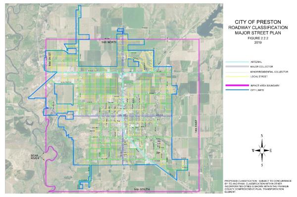
17.02.080 Major Street Plan
The major street plan for the city is incorporated and made a part of this zoning ordinance. Any proposed uses which would interfere with the streets as set forth in the major street plan and its accompanying map are prohibited unless specifically approved by the Planning and Zoning Commission and the City Council as set forth in this title. Figure 2.2.2
17.02.100 Existing Buildings And Land Uses
- Nonconforming buildings and uses. Buildings and uses lawfully established before the implementation of this code shall be permitted to continue, provided that such continued use is not contrary to the public health, safety, and welfare.
- Repairs. Repairs may be permitted to be made to any building or use without requiring the existing building or use to comply with the requirements of this code if said building or use was a legal use or building before the adoption of this title.
- Maintenance. Buildings or uses, both existing and new, and all parts thereof shall be maintained. The owner or owner's authorized agent shall be responsible for the maintenance of buildings and parcels of land. To determine compliance with this section, a code official shall be permitted to cause any structure or use to be inspected.
- Lots of record. Any single lot or parcel of land, which was of record and a legal lot at the time of adoption of the ordinance codified in this title, but does not meet the requirements of the district in which it is located for minimum lot width and area, may be utilized if all other requirements of this title are met.
- Residential uses, legally established prior to the enactment of this code may expand beyond the existing footprint of the building so long as all other provisions of this code are met regardless of existing zoning. Residential uses shall be governed under the provisions of the closest residential zone.
- If the property is redesigned for a different use, the property owner shall be deemed to have abandoned any grandfather right to the prior use of the property.