
Richmond City Zoning Code
ARTICLE 10
- ACCESS MANAGEMENT
Sec. 10.01.- Purpose.
The purpose of this article is to protect the substantial public investment in the city's street system by preserving the traffic capacity of existing streets. It is the further intent of this article to promote safe and efficient travel within the city; minimize disruptive and potentially hazardous traffic conflicts; establish efficient standards for driveway spacing and the number of driveways; and ensure reasonable vehicular access to properties, though not always the most direct access.
The standards are specifically designed for public streets classified as collector streets, arterials or thoroughfares in the master transportation plans for the city, county or state road authorities, whose primary function is the movement of through traffic.
Sec. 10.02. - Scope.
The standards of this article shall apply to all sites, uses, and developments subject to planning commission review that abut a public street classified as a collector or thoroughfare in the master transportation plans for the city, county or state road authorities. This article shall not apply to sites, uses, and developments exclusively abutting local streets whose primary function is to provide vehicular access to abutting lots.
The provisions of this article shall be applied to the extent determined reasonable and appropriate by the planning commission, in addition to any requirements of the Michigan Department of Transportation (MDOT) or county road authorities. If a conflict arises in the application of these provisions in conjunction with county or state road authority requirements, the more stringent standard shall apply.
Sec. 10.03. - Number of permitted driveways.
The number of non-residential driveways permitted per zoning lot shall be the minimum necessary, as determined by the planning commission, to provide reasonable access for regular traffic and emergency vehicles, while preserving traffic operations and safety along the public roadway. Such determinations shall be based on the street frontage of the zoning lot and the provisions of section 10.04 (driveway offsets and spacing standards), and the following:
1.
Where an existing site includes driveways that are not in conformance with the standards of this article, the planning commission may require the closing of one or more nonconforming driveways as part of any site plan approval.
2.
Where feasible, new vehicular access to a site shall be provided by a shared driveway, cross-access drive or service drive in accordance with section 10.05 (shared access).
3.
Additional driveways may be permitted where determined by the planning commission to adequately accommodate traffic or ensure public safety.
Sec. 10.04. - Driveway offsets and spacing standards.
Driveways along collector streets, arterials or thoroughfares accessory to multiple-family and non-residential uses and developments shall be located so as to minimize interference with the free movement of traffic, to provide adequate sight distance, and to provide the most favorable driveway grade. Vehicle access from public streets classified as a collector or thoroughfare in the master transportation plans for the city, county or state road authorities shall be subject to the following:.
A.
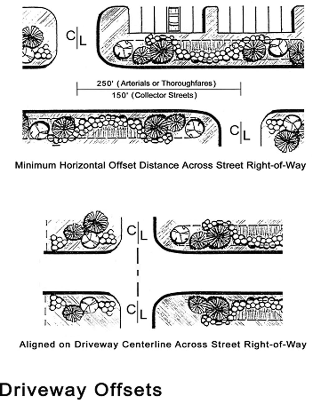
Driveway offsets along public rights-of-way. Where feasible, new driveways shall be aligned with existing driveways or streets on the opposite side of an collector or thoroughfare (see illustration).
1.
If such alignment is not feasible, new driveways shall be offset from existing driveways or streets a minimum of 250 feet along arterials or thoroughfares, and 150 feet along collector streets.
2.
Greater offsets may be required in accordance with the findings and recommendations of a traffic impact study conducted in accordance with section 10.06 (traffic impact studies).
3.
The planning commission may modify these standards based upon site and use locations and conditions.
B.
Driveway spacing standards. The minimum spacing between driveways and street intersections, and between separate driveways without traffic lights, shall be determined based upon the posted speed limit of the abutting collector street or thoroughfare.
The following minimum spacing standards are based on Michigan Department of Transportation (MDOT) standards and shall be measured from the centerlines of the driveways or street right-of-way:
Where a site has insufficient street frontage to meet the above standards, the planning commission may approve any of the following alternatives:
1.
The closing of at least one existing nonconforming driveway on the site, or construction of a new driveway access on an abutting local street.
2.
Location of a new driveway at a point that maximizes driveway spacing and separation distance.
3.
Indirect access via a shared driveway, service drive, or cross-access connection with an adjacent lot or use.
Sec. 10.05. - Shared access.
The development and use of shared driveways, cross-access drives, service drives, and similar means of shared access connecting two or more lots or uses shall be encouraged, in accordance with the purpose of this article. Upon determination that the number of vehicular access points along a collector street or thoroughfare is excessive based on the standards of this article, the planning commission may require the use of a shared driveway, cross-access drive or service drive to provide primary or secondary vehicular access as part of a site plan approval.
A.
Location. New shared driveways, cross-access drives, and service drives shall be aligned with existing drives on adjacent lots where feasible, and parallel or perpendicular to the street right-of-way.
B.
Cross-access easement. Shared driveways, cross-access drives, and service drives shall be located within a dedicated access easement that permits traffic circulation between lots, which shall be recorded with the county register of deeds office.
C.
Construction and materials. Shared driveways, cross-access drives, and service drives shall be paved with concrete, bituminous asphalt or similar hard-surfacing materials, in accordance with the construction and design standards established by the city. The grade of such drives shall be coordinated with existing or planned drives on adjacent lots.
D.
Temporary access. The planning commission may approve temporary driveways on the arterial street or thoroughfare as part of a site plan approval where continuation of shared access is not currently feasible, but is anticipated to be constructed within the next five years.
A performance guarantee shall be submitted by the applicant in accordance with section 1.06 (performance guarantees), to ensure closure and removal of the temporary access when the new shared access is constructed.
E.
Maintenance. The easement area shall remain clear of obstructions, and shall not be used for parking unless otherwise approved by the planning commission. Each property owner shall be responsible for maintenance of the shared access. A maintenance agreement may be required by the planning commission, subject to review and approval by the city attorney.
Sec. 10.06. - Traffic impact studies.
Where authorized by this ordinance or determined necessary by the planning commission, a traffic impact study (TIS) shall be prepared by an applicant to determine the potential future traffic conditions on the adjacent roadways once a proposed use is established or development is completed. The city may utilize its own traffic consultant to review the TIS, with the cost of the review being borne by the applicant per section 1.05 (fees).
The results of the TIS shall be used in the final design of access points and internal circulation and may identify necessary off-site road improvements. At a minimum, the TIS shall meet standards of the Southeastern Michigan Council of Governments (SEMCOG) and Michigan Department of Transportation (MDOT) handbook entitled Evaluating Traffic Impact Studies. The planning commission may modify the TIS requirements or scope based upon site and use location and conditions.
At a minimum, the TIS shall include the following:
1.
An analysis of existing traffic conditions and/or site restrictions using current data.
2.
Projected trip generation at the subject site or along the subject service drive based on the most recent edition of the Institute of Transportation Engineers' Trip Generation manual. The city may approve use of other trip generation data if based on recent studies of at least three similar uses within similar locations in Michigan.
3.
Illustrations of current and projected turning movements at access points, including identification of potential impacts of the development on the operation of the abutting streets. Capacity analysis shall be based on the most recent edition of the of the Transportation Research Board's Highway Capacity Manual, and shall be provided in an appendix to the TIS.
4.
Description of the internal vehicular circulation and parking system for passenger vehicles and delivery trucks, as well as the circulation system for pedestrians, bicycles and other users.
5.
Prediction of the peak-hour operational conditions at site driveways and road intersections affected by the development.
6.
Justification of need, including statements describing how any altered or additional access points will meet the intent of this article, preserve public safety and road capacity, and be consistent with the adopted master transportation plans for the city, county or state road authorities.
7.
Qualifications and documented experience of the author in preparing traffic impact studies in Michigan. The preparer shall be either a registered traffic engineer (P.E.) or a transportation planner, with at least three years of experience preparing traffic impact studies in Michigan. If the TIS includes geometric design, the study shall be prepared or supervised by a registered engineer with adequate experience in traffic engineering.
ILLUSTRATIONS
Sec. 10.07. - Gratiot Avenue Corridor Overlay Zone.
A.
Intent. The intent of the Gratiot Avenue Corridor Overlay Zone is to improve traffic operations and reduce potential for crashes through regulations on the number, spacing, placement and design of access points. Numerous published reports and recommendations by the Michigan Department of Transportation (MDOT) and other transportation organizations have identified a direct correlation between the number of access points and the number of crashes. Those studies also demonstrate that appropriate standards on the number and placement of access points (driveways and side street intersections) can preserve the capacity of a major corridor, like Gratiot Avenue, whose primary function is to move traffic, with a secondary function to provide reasonable access to properties along the road. The standards herein are based on recommendations published by various national and Michigan agencies that were refined during preparation of the Gratiot Avenue Corridor Improvement Plan.
Further, these regulations are intended to protect the substantial public investment in the road system and helps avoid the need for costly reconstruction, which causes traffic congestion with associated emissions and disrupts businesses. The procedures outlined in this section are intended to promote a more coordinated and expedited development review and approval process for site plans and access permits by the city, MDOT and the Road Commission of Macomb County (RCMC).
B.
Definitions.
1.
Access management: The process of providing and managing reasonable access to land development while preserving the flow of traffic in terms of safety, capacity, and speed on the abutting road system.
2.
Intersection: The junction where one road crosses another or where one road terminates into another approximately perpendicular road. Intersections, as referred to in this section, shall mean those both signalized and non-signalized.
3.
Reasonable access: The minimum number of access connections, direct or indirect, necessary to provide safe access to and from a public road. Reasonable access does not necessarily mean direct access.
C.
Applicability.
1.
The standards of this section shall apply to all land with frontage along Gratiot Avenue and all parcels that have all or a portion of its land within 500 feet of the Gratiot Avenue right-of-way. The access standards of this section do not apply to access that serves a single-family home, duplex or essential service facility structure.
2.
The regulations herein apply in addition to, and simultaneously with, the other applicable regulations of the zoning ordinance.
3.
The following applications must also comply with the standards in this section.
a.
New or enlarged building or structure. No new principal building or structure, nor the enlargement of any principal building or structure by more than 25 percent, shall be erected unless the regulations in this overlay zone are met and maintained in connection with such building, structure, or enlargement.
b.
Reconstruction. No enlargement or reconstruction of on-site parking facilities by more than 25 percent shall be approved unless in compliance with this overlay zone. (This does not apply to milling and resurfacing).
c.
Land division, subdivision or site condominium. No land division or subdivision or site condominium project within the overlay zone shall be approved unless it is demonstrated access to the site is in compliance with the standards herein.
d.
Change in use or intensity of use. Any change in use, intensity of use or increase in vehicle trips generated on a site that does not meet the access standards of this overlay zone shall be required to submit a site plan for approval by the planning commission and submit information to the MDOT and/or RCMC to determine if a new access permit is required.
e.
Extension of site plan approval. In the event that a site plan extension request is made, planning commission shall determine the extent to which the standards apply. Planning commission's decision may be based on considerations such as the number of previous extensions granted to the site plan and the feasibility of accommodating the standards.
4.
The approval of a land division or site plan application does not negate the responsibility of an applicant to subsequently secure access permits from the road agency (MDOT along Gratiot Avenue or any state trunkline and the appropriate road commission or the City of Richmond).
5.
Where conflict occurs between the city regulations and road agency regulations, the more restrictive regulations shall apply.
D.
Submittal information. In addition to the submittal information required for site plan review in section 18.02 (required information for site plans), the following shall be provided with any application listed in subsection C. above:
1.
Existing access points. Existing access points within 500 feet along both sides of the road frontage and along both sides of any adjoining intersecting roads shall be shown on the site plan, aerial photographs or on a plan sheet.
2.
Existing and proposed driveways. Dimensions shall be provided for existing and proposed driveways (width, radii, throat length, length of any deceleration lanes or tapers, pavement markings and signs) and all curb radii within the site. Dimensions must also be provided between the existing and proposed driveways within the site and access points within 500 feet along both sides of the Gratiot Avenue frontage and, for corner lots, those along both sides of any adjoining intersecting roads.
3.
Sites not otherwise subject to planning commission review. Where site access is being reviewed due to a change in use or intensification of use or traffic generated, the city may allow submittal of a sketch plan that contains only the information necessary to review such access. At a minimum, the information required by items 1.—3. above must be provided on a scaled drawing of the overall site conditions.
E.
Access management standards. The regulations of this section shall be considered by the planning commission during review of access points, streets, private roads and driveways subject to review according to this section.
1.
Compliance with Corridor Plan. Where property is illustrated in the Gratiot Avenue Corridor Improvement Plan, or other corridor plan, such access shall be provided as shown to the extent possible, as determined by the planning commission.
2.
Review coordination. The city may contact MDOT and/or RCMC for the opportunity to provide input on the city's decisions on access. Any access permit from the road agency shall be consistent with the city's decision on a site plan or special land use application. An access permit may not be approved by a road agency until the land division or site plan is approved by the city.
3.
Number of access points. The number of access points, either existing or proposed, shall be the fewest necessary to provide motorists reasonable access to the site. Each lot shall be permitted one access point. Depending on site conditions, this access point may consist of an individual driveway, a shared access with an adjacent use, or access via a service drive.
4.
Additional access point. An additional access point may be permitted by the planning commission upon finding that one or more of the following, as applicable, are met:
a.
A need for an additional access point has been demonstrated, and the additional access point will not create negative impacts on through traffic flow or operations. The planning commission may require the submittal of a traffic impact study, prepared in accordance with subsection G. below, to demonstrate the need; and
b.
A poor level of service will result if access is provided that meets the location and spacing standards and the additional driveway will improve the overall level of service both within the site and on the road.
OR
a.
The site has adequate frontage to meet the spacing standards between access points listed below, and the additional access will not prevent adjacent lands from complying with the access spacing standards when such lands develop or redevelop in the future; and
b.
The additional access point will not create conflicts with access points on adjacent properties or median crossovers, will not create a nonconforming situation for an existing or expected access for an undeveloped site, or it will make an existing nonconforming situation more conforming; and
c.
If necessary, the site plan includes facilities (such as easements or access agreements) that will allow future shared access to neighboring properties or will implement existing opportunities to provide shared access when the driveway is constructed; and
d.
The additional driveway is a necessity rather than just a convenience; and
e.
The additional access is acceptable to the MDOT along Gratiot Avenue or any state trunkline and the RCMC for other roads.

5.
Spacing of access points on same side of road. Access points shall provide the following spacing from other access points along the same side of the public street (measured from centerline to centerline as shown on the figure), based on the posted speed limit along the abutting road segment, according to the following table.

6.
Offset from access points on opposing side of road. Access points shall be aligned with driveways on the opposite side of the road or offset a minimum of 250 feet (measured from centerline to centerline). The planning commission may reduce this to not less than 150 feet where each of the opposing access point generates less than 50 trips (inbound and outbound) during the peak hour or where existing driveways or sight distance limitations exist.
7.
Spacing from intersections. Minimum spacing of access points from signalized intersections (measured from road edge to road edge) shall be at least 300 feet from an intersection along Gratiot Avenue.
8.
Consideration of adjacent sites. Where the subject site adjoins land that may be developed or redeveloped in the future, the access shall be located to ensure the adjacent site(s) can also meet the access location standards in the future.

9.
Shared driveways and service drives. Where direct access consistent with the above regulations cannot be achieved, access should be provided via a shared driveway or service drive. In particular, the planning commission may require development of service drives where such facilities can provide access to signalized locations, minimize the number of driveways, or provide an efficient means of ingress and egress.
Service drives shall be constructed in accordance with the following standards:
(i)
Service drives shall generally be parallel or perpendicular to the front property line and may be located either in front of, adjacent to, or behind, principal buildings. In considering the most appropriate alignment for a service road, the planning commission and the RCMC and/or MDOT shall consider the setbacks of existing buildings and anticipated traffic flow for the site.
(ii)
The service drive shall be located within an access easement permitting traffic circulation between properties. This easement shall be approved by the city and the RCMC/MDOT and recorded with the Macomb County Register of Deeds. The required width shall remain free and clear of obstructions, unless otherwise approved by the planning commission. Each property owner shall be responsible for maintenance of the easement and service drive.
(iii)
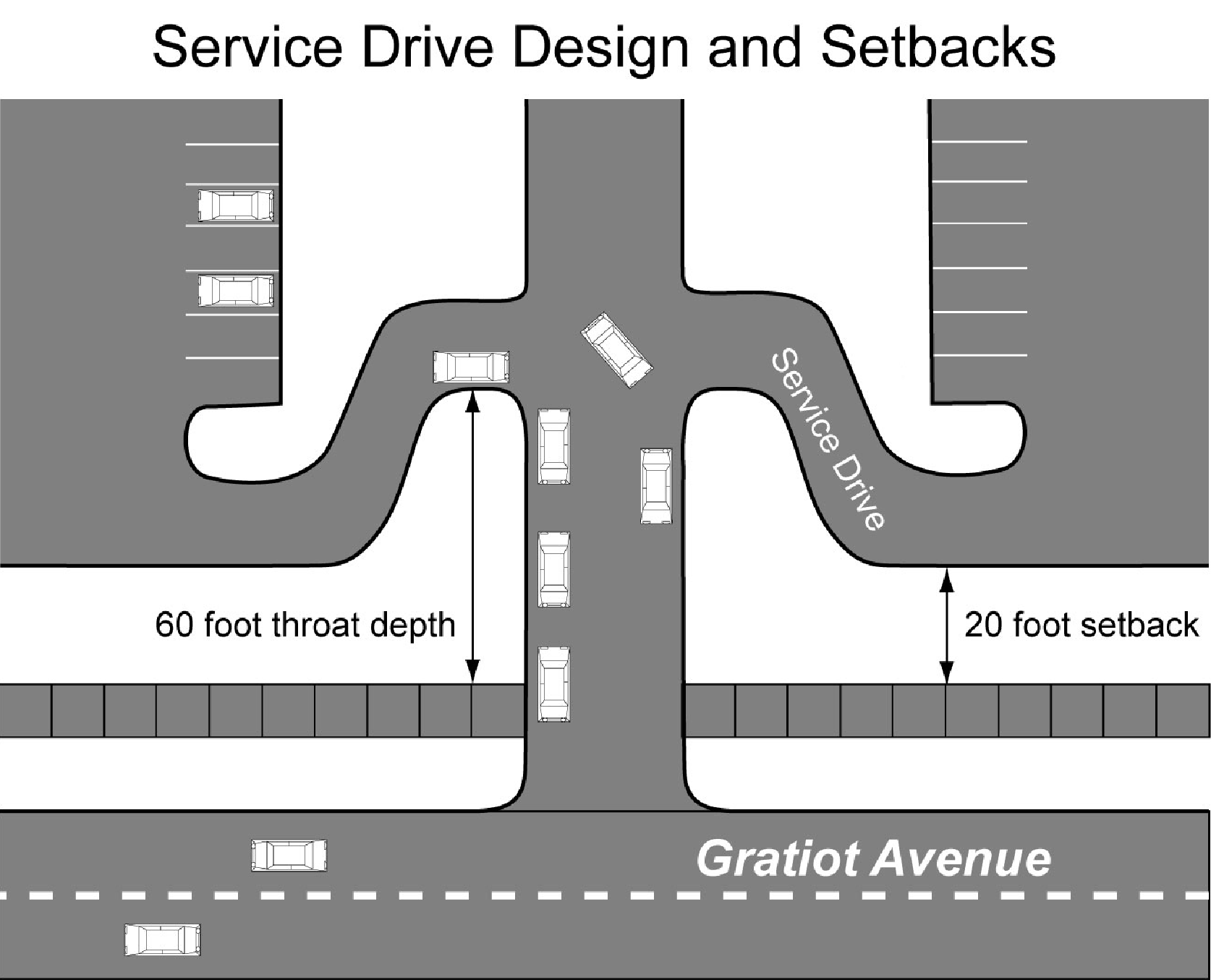
A minimum of 20 feet shall be maintained between the road right-of-way and the pavement of the service drive, with at least 60 feet of throat depth provided at the access point, where practical, measured between the road right-of-way and the intersecting service drive.
(iv)
Service drives shall have a minimum pavement width of 24 feet and be constructed of either concrete or asphalt with curb and gutter. The planning commission may modify these standards based upon site conditions, anticipated volumes and types of automobile and truck traffic.
(v)
Where a service drive is stubbed or intended to be extended onto an adjacent property in the future, the site plan shall indicate the proposed elevation of the service drive at the property line so that the city can maintain a record of all service road elevations and their grades can be coordinated with future developments.
(vi)
In cases where a shared access facility is recommended, but is not yet available, temporary direct access may be permitted, provided the plan is designed to accommodate the future service drive, and a written agreement is submitted that the temporary access will be removed by the applicant, when the alternative access system becomes available. The planning commission may require posting of a financial performance guarantee to ensure compliance with such agreement.
(vii)
If, during redevelopment of existing sites, it is not possible to develop separate service drives, the planning commission and RCMC/MDOT may instead require a drive connecting parking lots with adjacent sites.
10.
Sight distance. Driveways shall be located to provide safe sight distance, as determined by the staff of MDOT and/or RCMC.
F.
Modification of access standards. Modifications to the standards herein may be permitted by the planning commission according to the following procedure:
1.
Allowed modifications. The planning commission may, after considering the criteria in #2 below, modify the standards of this section in the following situations:
a.
The modification will allow an existing driveway to remain that does not meet the standards of this section but that has, or is expected to have very low traffic volumes (less than 50 in- and out-bound trips per day) and is not expected to significantly impact safe traffic operations.
b.
The use is expected to generate a relatively high number of trips and an additional driveway will improve overall traffic operations.
c.
Practical difficulties exist on the site that make compliance unreasonable (sight distance limitations, existing development, topography, unique site configuration or shape), or existing off-site driveways make it impractical to fully comply with the standards.
d.
Because of restricted turning movements or presence of a median that restricts turning movements, the driveway does not contribute to congestion or an unsafe situation.
2.
Modification criteria. The planning commission may waive certain requirements of this section upon consideration of the following:
a.
The proposed modification is consistent with the general intent of the standards of this overlay zone, the recommendations of the Gratiot Avenue Corridor Improvement Plan, and published MDOT guidelines.
b.
MDOT staff endorse the proposed access design.
c.
Driveway geometrics have been improved to the extent practical to reduce impacts on traffic flow.
G.
Traffic impact studies. Where required by this ordinance or determined necessary by the planning commission, a traffic impact study (TIS) shall be prepared by an applicant to determine the potential future traffic conditions on the adjacent roadways once a proposed use is established or development is completed. The city may utilize its own traffic consultant to review the TIS, with the cost of the review being borne by the applicant.
The results of the TIS shall be used in the final design of access points and internal circulation and may identify necessary off-site road improvements. At a minimum, the TIS shall meet standards of the Southeastern Michigan Council of Governments (SEMCOG) and Michigan Department of Transportation (MDOT) handbook entitled Evaluating Traffic Impact Studies. The planning commission may modify the TIS requirements or scope based upon site and use location and conditions.
Traffic impact studies shall contain the following minimum information:
1.
An analysis of existing traffic conditions and/or site restrictions using current data.
2.
Projected trip generation at the subject site or along the subject service drive based on the most recent edition of the Institute of Transportation Engineers' Trip Generation manual. The city may approve use of other trip generation data if based on recent studies of at least three similar uses within similar locations in Michigan.
3.
Illustrations of current and projected turning movements at access points, including identification of potential impacts of the development on the operation of the abutting streets. Capacity analysis shall be based on the most recent edition of the of the Transportation Research Board's Highway Capacity Manual, and shall be provided in an appendix to the TIS.
4.
Description of the internal vehicular circulation and parking system for passenger vehicles and delivery trucks, as well as the circulation system for pedestrians, bicycles and other users.
5.
Prediction of the peak-hour operational conditions at site driveways and road intersections affected by the development.
6.
Justification of need, including statements describing how any altered or additional access points will meet the intent of this article, preserve public safety and road capacity, and be consistent with the adopted master transportation plans for the city, county or state road authorities.
7.
Qualifications and documented experience of the author in preparing traffic impact studies in Michigan. The preparer shall be either a registered traffic engineer (P.E.) or a transportation planner, with at least three years of experience preparing traffic impact studies in Michigan. If the TIS includes geometric design, the study shall be prepared or supervised by a registered engineer with adequate experience in traffic engineering.
(Ord. No. 156-11, § I, 11-2-09)