
Roswell City Zoning Code
ARTICLE 8
- OVERLAY DISTRICTS
Sec. 8.2. - -HD: Historic District[1]
Editor's note— Ord No. 2020-03-02, § 3, adopted March 9, 2020, repealed the former Sec. 8.2, §§ 8.2.1—8.2.4, and enacted a new Sec. 8.2 as set out herein. The former Sec. 8.2 pertained to -HOD: Historic Overlay District and derived from the original Code.
8.1.1. - Purpose and Intent
A.
The River Corridor (-RC) overlay is intended to clarify the geographic extent of the jurisdiction of the Atlanta Regional Commission (ARC) under the Metropolitan River Protection Act (O.C.G.A. § 12-5-440 et seq.), which addresses environmental and development matters in the Chattahoochee River corridor and its drainage basins.
B.
The Metropolitan River Protection Act has an express purpose to provide a method for cities like Roswell to apply the police power of the state, in accordance with a comprehensive plan, for the following purposes:
1.
To protect consistently the water quality of any major stream, the public water supplies of such political subdivision and of the area, recreational values of the major stream, and private property rights of landowners;
2.
To prevent activities which contribute to floods and flood damage;
3.
To control erosion, siltation, and intensity of development;
4.
To provide for the location and design of land uses in such a way as to minimize the adverse impact of development on the major stream and flood plains; and
5.
To provide for comprehensive planning for the stream corridor in such areas.
C.
The general boundaries of -RC overlay are shown the Official Zoning Map. The exact boundaries are determined by the Atlanta Regional Commission in accordance with the Chattahoochee Corridor Plan and the Metropolitan River Protection Act. The boundaries are measured from the river bank, and therefore change from time to time due to natural erosion and accretion processes.
8.1.2. - ARC Authority for Review
The Atlanta Regional Commission has authority to review any building or land disturbance within the -RC overlay, in addition to development review by the City of Roswell. Review is conducted to ensure compliance with the adopted Chattahoochee Corridor Plan and the Metropolitan River Protection Act.
8.1.3. - Required Buffer
A 50-foot natural vegetative buffer must be maintained along the River and a 35-foot buffer along any streams. All structures and impervious surfaces must be 150 feet from the River.
8.2.1. - Purpose and Intent
The historical, architectural, cultural and aesthetic heritage of Roswell is among the City's most valued and important assets. The purpose of the -HD and accompanying regulations is to safeguard the heritage of Roswell by preserving the City's historic and architecturally worthy properties, areas, buildings, structures, monuments, streetscapes, squares, landscapes, archaeology, and neighborhoods.
(Ord No. 2020-03-02, § 3, 3-9-2020)
8.2.2. - Permitted Uses
Property in the -HD may be used for any use allowed in the underlying zoning district (see Articles 3 through 8).
(Ord No. 2020-03-02, § 3, 3-9-2020)
8.2.3. - Dimensional Requirements
Development in the -HD must meet the dimensional requirements of the underlying zoning district (see Articles 3 through 8), except as otherwise required by this section.
(Ord No. 2020-03-02, § 3, 3-9-2020)
8.2.4 - Properties in the Historic District
A.
The Historic District Regulating Plan is the zoning control document in the HD for those requirements depicted graphically on it. It is incorporated into and adopted concurrent with this Section by reference and is kept in the official minute book of the City.
B.
The Historic District Regulating Plan establishes requirements for the following:
1.
Regulating character areas;
2.
Primary street setbacks (see Sec. 8.2.5);
3.
Side street setbacks (see Sec. 8.2.5); and
4.
Where a 40-foot wooded landscape strip is required along parts of State Route 9.
C.
When the Historic District Regulating Plan does not establish a requirement for a location, the underlying zoning district regulations apply.
D.
Amendments to the Historic District Regulating Plan are subject to requirements for text amendments established in Article 13.
(Ord No. 2020-03-02, § 3, 3-9-2020; Ord. No. 2022-07-11, § 1, 7-25-2022)
Editor's note— Ord. No. 2022-07-11, § 1, adopted July 25, 2022, changed the title of § 8.2.4 from "Historic District Regulating Plan" to read as herein set out.
8.2.4.1 - Historic Properties Map
The Historic Properties Map, as adopted by Mayor and City Council on April 14, 2003, classifies land parcels in the Historic District into the following five categories: Historic, Historic-Obscured, Intrusion, Non-Historic, and Vacant. The category definitions are established as the following:
1.
Historic: Structures, buildings or objects that were more than fifty years old in 2001 and contribute to the character of the district.
2.
Historic-obscured: Structures, buildings or objects that were more than fifty years old in 2001 but do not contribute to the historic character of the district due to unsympathetic but not irreparable alterations.
3.
Non-historic: Structures, buildings or objects that were less than fifty years old in 2001 but contribute to the historic character of the district by possessing architectural character.
4.
Intrusion: Structures from any year that detract from the historic character of the district.
5.
Vacant.
(Ord. No. 2022-07-11, § 2, 7-25-2022)
8.2.4.2 - Historic District Regulating Plan
A.
The Historic District Regulating Plan is the zoning control document in the HD for those requirements depicted graphically on it. It is incorporated into and adopted concurrent with this Section by reference and is kept in the official minute book of the City.
B.
The Historic District Regulating Plan establishes requirements for the following:
1.
Regulating character areas;
2.
Primary street setbacks (see Sec. 8.2.5);
3.
Side street setbacks (see Sec. 8.2.5); and
4.
Where a 40-foot wooded landscape strip is required along parts of State Route 9.
C.
When the Historic District Regulating Plan does not establish a requirement for a location, the underlying zoning district regulations apply.
D.
Amendments to the Historic District Regulating Plan are subject to requirements for text amendments established in Article 13.
(Ord. No. 2022-07-11, § 3, 7-25-2022)
8.2.5 - Setbacks
A.
When the Historic District Regulating Plan establishes a primary street or side street setback, that setback is a minimum setback that applies instead of the one in the underlying zoning district regulations.
B.
When the Historic District Regulating Plan establishes a primary street or side street setback, there is no maximum setback.
(Ord No. 2020-03-02, § 3, 3-9-2020)
8.2.6. - Landscape Strip
A.
When the Historic District Regulating Plan establishes a required minimum 40-foot wooded landscape strip along portions of State Route 9, the landscape strip applies instead of the primary street setback in the underlying zoning district regulations.
B
The required landscape strip must be planted with native overstory and native understory trees as follows:
1.
Overstory trees must be planted no more than 40 feet on center.
2.
Understory trees must be planted no more than 25 feet on center
C.
To the extent practical, existing vegetation must be used to meet this requirement. Where the natural vegetation is insufficient, supplemental plantings must be used.
(Ord No. 2020-03-02, § 3, 3-9-2020)
8.2.7. - Buildings
A.
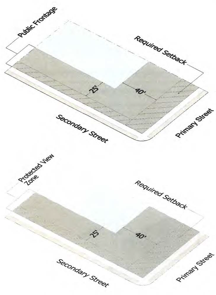
The building types allowed in a Protected View Zone, the maximum façade width in a Protected View Zone, and maximum allowed principal building heights are established and required by regulating character areas as follows:
B.
Protected View Zone, as used above, means the portion of a site that includes:
1.
The area between the primary street right-of-way and a line 40 feet past the required primary street setback; and
2.
The area between the side street right-of-way and a line 25 feet past the required side street setback.
3.
In calculating the above, the setbacks shown on the Historic District Regulating Plan will be used. When a site is not subject to the Historic District Regulating Plan, the minimum setback required by the UDC will be used.
C.
Building Types Allowed in Protected View Zone. When the table in "A" above establishes allowed building type in a Protected View Zone "per regulating character area", all portions of new buildings in a Protected View Zone must match one of the building types present on an officially designated historic building in the same regulating character area. For the purpose of this requirement only, detached houses, attached houses, commercial houses, and cottage courts are considered to be the same "house" building type.
D.
Façade width in a Protected View Zone.
1.
When the table in "A" above establishes façade widths in a Protected View Zone, this refers to the street-facing width of a single building along a single street (measured perpendicular to the right-of-way of such street). When a building faces multiple streets, the width is calculated separately per street.
2.
All street-facing building facades along the same street and on the same lot are considered a single building for the purpose of these façade width requirements, unless one or more of the following occurs:
a.
The facades are located on separate buildings (per building code) and a minimum separation of 10 feet exists between all portions of such buildings in a Protected View Zone; or
b.
The facades are located on a single building (per building code) and an at-grade open space with a minimum width of 10 feet and a minimum depth of 30 feet is provided between adjacent facades.
E.
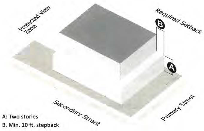
Stepback in a Protected View Zone.
1.
When the above table requires a stepback in a Protected View Zone, all stories above the second must be set back at least 10 feet behind the street-facing facade of the second story. This is only for the South Alpharetta/Atlanta Street character area and the North Alpharetta/Atlanta Street character area. This means that in these character areas within the protected view zone, a building may have three stories, but the third story must contain a stepback of ten feet above the second story when the façade is 80 feet in width or less. A façade that is over 80 feet in width has a maximum of two stories in the protected view zone.
2.
When a Protected View Zone contains portions of two or more buildings (one in the front and one in the rear), the requirement of "1" above does not apply to facades on rear building that are fully screened by the front building (vertically and horizontally) from view from the public right-of-way.
F.
Neighborhood compatibility bulk planes required by the underlying zoning district regulations apply in the -HD.
(Ord No. 2020-03-02, § 3, 3-9-2020)
8.2.8. - Conditional Use Permits, Concurrent Variances, and Rezoning Requests
All applications for conditional use permits, concurrent variances, and rezoning must demonstrate conformance with the requirements of this Section. Applications that do not include conformance with this Section or indicate an intention for request alternative compliance will be deemed incomplete.
(Ord No. 2020-03-02, § 3, 3-9-2020)
8.2.9. - Certificate of Appropriateness
A Certificate of Appropriateness from the Roswell Historic Preservation Commission is required per Sec. 13.7.
(Ord No. 2020-03-02, § 3, 3-9-2020)
8.2.10. - Alternative Compliance
A.
Alternative compliance allows a project to use an alternative design approach to satisfy a particular standard of this section, only as identified in "C" below.
B.
Alternative compliance is not a variance, which provides relief from a requirement considered to be an unnecessary hardship. Alternative compliance is required to meet the intent of the applicable standard in an alternative way.
C.
The Historic Preservation Commission has the authority to review and approve alternatives to the following standards of this Section as part of a Certificate of Appropriateness or Major Design Review:
1.
To modify setback requirements in the -HD, including those shown on the Historic District Regulating Plan and in the underling zoning district regulations, when applicable, but not to the required 40-foot wooded landscape strip along portions of State Route 9.
2.
To increase the allowed principal building height, provided such increase does not exceed the limits otherwise required by this UDC.
3.
To reduce or eliminate a stepback requirement.
4.
To permit a building type along streets that is not found on an officially designated historic building in the regulating character area, but is found on an official designated historic building in the -HD.
5.
To increase the maximum allowed façade width in a Protected View Zone.
D.
Alternative compliance may not be used to provide relief from the required 40-foot wooded landscape strip along portions of State Route 9. Alternative compliance may not be used to provide relief from a condition imposed by City Council or any other regulation not required by this section.
E.
The Historic Preservation Commission may only approve alternative compliance when it finds that:
1.
There are clear and compelling reasons that are not financial why the required standard cannot be met;
2.
The alternative design approach satisfies the intent of the -HD;
3.
The alternative design approach satisfies the approval criteria for certificates of appropriateness;
4.
The alternative design approach demonstrates exceptional conformance with Historic Preservation Commission Guidelines contained in Part C of the UDC Guidelines; and
5.
The alternative design approach conforms with the Comprehensive Plan and the Historic District Master Plan.
F.
Any determination made by the commission relative to the approval or denial of a decision regarding alternative compliance is an automatic appeal to the Mayor and Council. The governing body may approve, modify and approve, or reject the determination made by the commission if the governing body finds that the commission abused its discretion in reaching its decision. On appeal, the Mayor and Council will give deference to the Historic Preservation Commission's decision, if the decision was based on the criteria set forth in letter "E" above.
(Ord No. 2020-03-02, § 3, 3-9-2020)
8.3.1. - Purpose and Intent
The purpose of the Neighborhood Conservation (-NC) overlay is to protect the unique character of an established area by requiring new development to be consistent with the unique, character-defining elements of the area.
8.3.2. - Criteria for Designation
All of the following criteria for designation must be met before an application to create an -NC overlay will be considered:
A.
The area must be mostly residential in character.
B.
The area must have been developed at least 25 years, and at least 85% of the land in the proposed area must be presently improved.
C.
The area must include at least one block face (all lots on one side of a block).
D.
The area must create a consistent setting, character, or association by possessing at least one of the following character-defining elements:
1.
Consistent scale, size, type of construction or distinctive building material;
2.
Consistent lot layout, setback, street or alley layout; or
3.
Special streetscape characteristics.
8.3.3. - Establishment of -NC Overlay
A.
An -NC overlay may only be established as both a Zoning Map Change and Text Amendment in accordance with the requirements of Sec. 13.4. to codify the standards and boundaries established within the overlay.
B.
Multiple -NC overlays must not be designated over any individual property. A property may only be located within one -NC overlay.
C.
The overlay and any associated standards must reflect the prevailing subdivision layout or building design in the area.
D.
The Zoning Director must review the proposed -NC overlay boundary and any associated standards to determine their conformity with the requirements of this Section. As part of this review, the City must hold at least one neighborhood meeting to ensure neighborhood support for the request prior to initiating the rezoning process.
8.3.4. - Modification of Standards
A.
The -NC overlay may modify any of the following standards within this UDC:
1.
Dimensional requirements in Articles 3 through 8;
2.
Site development standards in Article 10; and
3.
Street and block standards in Article 11.
B.
The -NC overlay may allow for restrictions on building design or placement details, including scale, mass, building materials and architectural style, provided the required standards reflect the prevailing character of the designated area. Elements that may be regulated include, but are not limited to:
1.
Lot area or width.
2.
Principal or accessory structure height or number of stories.
3.
Setbacks.
4.
Building width and articulation.
5.
Building elements such as porches or balconies.
6.
Architectural style, roof materials and style, or building materials.
7.
Streetscape or landscaping, including fences, walls and screening.
8.
Driveways, paving and parking location.
C.
Any modified standards applicable within the -NC overlay must be expressly set forth in the overlay district at the time of adoption.