
Roswell City Zoning Code
ARTICLE 1
- GENERAL PROVISIONS
Sec. 1.2. - Zoning Districts Established
In order to carryout the purposes of this UDC, the City is divided into the following zoning districts as established on the Official Zoning Map in Sec. 1.3.
1.1.1. - Title
This document is the "The Unified Development Code for the City of Roswell, Georgia," and is referred to or cited throughout the document as "this UDC."
1.1.2. - Purpose
This UDC is intended to serve the following purposes:
A.
To promote and protect the public health, safety and welfare of the citizens of Roswell;
B.
To ensure that the vision set forth in the Comprehensive Plan is implemented by the City's development regulations;
C.
To promote environmental, economic and social sustainability;
D.
To protect the physical environment, historic character and natural resources for all citizens;
E.
To preserve, protect and enhance the City's employment base;
F.
To promote development patterns that support safe, effective and multi-modal transportation options; and
G.
To provide a system for the development of lands and the accurate recording of land titles.
1.1.3. - Application
A.
Territorial Application. This UDC applies to all land, uses, buildings and structures within the corporate boundaries of the City.
B.
General Application. In their interpretation and application, the provisions of this UDC are the minimum requirements for the promotion and protection of the public health, safety and welfare.
C.
Required Conformance. All buildings, structures or land, in whole or in part, must be used or occupied, in conformance with this UDC. All buildings or structures, in whole or in part, must be erected, constructed, moved, enlarged or structurally altered in conformance with this UDC.
D.
Control Over Less Restrictive Private Agreements. This UDC does not nullify any private agreement or covenant. However, where this UDC is more restrictive than a private agreement or covenant, this UDC controls. The City will not enforce any private agreement or covenant.
E.
Control Over Less Restrictive Laws and Regulations. If any condition or requirement imposed by this UDC is more restrictive than a condition or requirement imposed by any other law, rule or regulation of any kind, the more restrictive condition or requirement governs.
F.
Conflict. If any condition or requirement imposed by this UDC contains an actual, implied or apparent conflict, the more restrictive condition or requirement controls.
G.
References to Other Laws. Whenever a provision of this UDC refers to any other part of the Roswell City Code or to any other law, the reference applies to any subsequent amendment of that law.
H.
Text and Graphics. Illustrations, photographs and graphics are included in this UDC to illustrate the intent and requirement of the text. In the case of a conflict between the text of this UDC and any Illustrations, photographs and graphics, the text governs.
1.1.4. - Severability
If any section, paragraph, subdivision, clause, sentence or provision of this UDC is adjudged by any court of competent jurisdiction to be invalid, that judgment does not affect, impair, invalidate or nullify the remainder of this UDC. The effect of the judgment is confined to the section, paragraph, subdivision, clause, sentence or provision immediately involved in the controversy in which judgment or decree was rendered.
1.1.5. - Effective Date
This UDC was adopted on February 24, 2014 and became effective on June 1, 2014.
1.1.6. - Prior Approval Conditions
A.
Appendix A includes approvals of rezoning and conditional uses from January 1, 2000 to June 1, 2014. This also includes lawsuit and targeted properties and protected districts. When a property abuts a protected district, the site plan shall be reviewed and approved by Mayor and City Council. All lighting conditions within the appendix shall be allowed to follow the current code due to new technology.
B.
Site plans that specify and limit the number of building units; for example, apartments, dwelling units or buildings, are also included in this Appendix.
C.
Items controlled by conditions of approval such as days and hours of operation, buffers, limitations of uses, noise levels shall be enforceable.
D.
As related to property owned by the Roswell Housing Authority (see map below). which is within the area bounded by south of Oak Street, east of Bush Street, North of Oxbo Road, such property is governed by the conditions of rezoning identified in Ordinance No. 2012-04-06 approved in April 9, 2012 for the Groveway Community Overlay District.
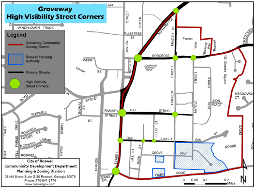
E.
In the former Groveway Community Overlay District shown in the map above, the following requirements apply:
1.
High Visibility Street Corner Street Corner Site Design Options. All development proposals located at designated High Visibility Street Corner sites shall include at least one of the design treatments described below. All buildings located on street corners must be oriented diagonally, facing the intersection. High Visibility Street Corners are designated on the Groveway Community Map.
a.
Locate a building within 15 feet of the street corner, with building diagonally oriented toward intersection.
b.
Install substantial landscaping adjacent to the street corner. The subject area must be 400 square feet of ground surface area with hardscape elements making up at most 25% of the space. Planted areas should contain a combination of trees, shrubs, perennials, and ground cover that provides four-season interest.
2.
Public Art. For the purposes of this section, "public art" shall mean the creation of an original work or service of an artist for a publicly accessible space which could be, but is not limited to, earthworks, mosaics, murals, and sculpture. Commercial, industrial, mixed-use project and parking structure over 25,000 square feet of gross floor area, as well as structures located at high visibility street corners shall incorporate in their design a public art component. For the purpose of this Section, the gross floor area calculation shall include parking garages (including below grade and at or above grade garages). All City construction projects shall also incorporate in their design a public art component. The minimum standard of performance used to measure compliance with this section shall be that the public art component shall have a value of not less than 1% of the building permit valuation. This section shall not apply to a project:
a.
Having a fully executed development agreement, approved before the effective date of the ordinance enacting this Section;
b.
For which a building permit was issued before the effective date of the ordinance enacting this section. A building permit for additions to the same project which is issued after the effective date of the ordinance enacting this section shall be subject to this section.
(Ord. No. 2019-03-12, §§ 1, 2, 3-25-2019)
1.2.1. - Residential Districts
A.
Single-Family Detached Districts
1.
AG-43: Agricultural Residential
2.
RS-87: Single-Family Estate
3.
RS-30: Single-Family Estate
4.
RS-18: Single-Family Suburban
5.
RS-12: Single-Family Suburban
6.
RS-9: Single-Family Small Lot
7.
RS-6: Single-Family Small Lot
8.
RS-4: Single-Family Small Lot
B.
Attached and Multi-Family Districts
1.
R-CC: Residential Cottage Court
2.
R-TH: Residential Townhouse
3.
RM-2: Residential Multi-Family
4.
RM-3: Residential Multi-Family
C.
Planned Districts
1.
PRD: Planned Residential Development
1.2.2. - Corridor and Node Districts
1.
RX-: Residential Mixed Use
2.
NX-: Neighborhood Mixed Use
3.
CX-: Commercial Mixed Use
4.
SH-: Shopfront Mixed Use
5.
CC-: Commercial Corridor
6.
PV-: Parkway Village
7.
CH-: Commercial Heavy
1.2.3. - Downtown Historic Districts
1.
DR-: Downtown Residential
2.
DX-: Downtown Mixed Use
3.
DS-: Downtown Shopfront
4.
DH-: Downtown House
1.2.4. - Employment Districts
1.
OR-: Office Residential
2.
OP-: Office Park
3.
IX-: Industrial Flex
4.
IL-: Light Industrial
1.2.5. - Civic and Open Space Districts
1.
CIV: Civic and Institutional
2.
REC: Parks and Recreation
3.
CON: Conservation and Open Space
1.2.6. - Overlay Districts
1.
-RC: River Corridor Overlay
2.
-HOD: Historic Overlay District
3.
-NC: Neighborhood Conservation Overlay
1.3.1. - Official Zoning Map Established
A.
The Official Zoning Map for the City of Roswell is incorporated and made part of this UDC.
B.
The boundaries of the zoning districts listed in Sec. 1.2. are shown and established on the Official Zoning Map.
C.
The original Official Zoning Map is kept in the official minute book of the City and it must indicate the date of the adoption and most recent amendment.
D.
The Official Zoning Map may be kept electronically in a Geographic Information System. Any copy of the Official Zoning Map published on the web or otherwise portrayed electronically does not constitute the original Official Zoning Map.
E.
The Zoning Director may make paper copies of the Official Zoning Map available to the public for a reasonable fee.
1.3.2. - Interpretation of Map Boundaries
Where uncertainty exists with respect to the boundaries of any zoning district on the Official Zoning Map, except the Historic Overlay District, the Zoning Director is authorized to interpret the boundaries using the following methods.
A.
Where a district boundary line is shown as approximately following the centerline of a street or highway, or an extension of a street or highway, the district boundary is the centerline of that street or highway.
B.
Where a district boundary line is shown as running approximately parallel at a distance from the centerline of a street or highway, the distance from the centerline must be determined by the use of the scale shown on map.
C.
Where a district boundary line is shown as approximately following a lot line, the district boundary is the lot line.
D.
Whenever any street, alley or other public way is vacated or abandoned by official action of the City Council, the zoning district adjoining each side of the street, alley or public way will be automatically extended to the center of the street, alley or public way.
E.
Where a boundary line is shown and its location is not fixed by any of the rules of this sub-section, its precise location is determined by scaling from fixtures, objects, or other structures shown on the map.
1.4.1. - Use and Enforcement of Design Guidelines
A.
The Unified Development Code Design Guidelines adopted by Mayor and City Council by Resolution and subsequently amended and adopted by reference in this Article are flexible in interpretation of compliance of the design standards as determined by staff, and the Design Review Board or the Historic Preservation Commission, whichever has jurisdiction, in the case of individual development applications.
B.
It is the intent of this Article that all development be in accordance with the applicable standards established in the UDC Design Guidelines, but that the final authority to determine whether a development is consistent or inconsistent with these guidelines shall rest with the Design Review Board or the Historic Preservation Commission, whichever has jurisdiction, subject to appeal provisions. To this end, the Board or Commission may exercise its own judgment in applying these design guidelines and may approve variations or determine such guidelines to be not applicable as they pertain to a particular piece of property or development where, in the Board's or Commission's judgment, the spirit and intent of the guidelines are maintained or that the resulting development, absent consistency with these guidelines, will be appropriate and compatible with the uses and structures within the respective overlay district, design district, or citywide, as the case may be.