
Roswell City Zoning Code
ARTICLE 11
- STREETS AND PUBLIC IMPROVEMENTS
11.1.1. - Applicability
The Article applies to any Minor Plat, Preliminary Plat, Final Plat, Design Plan, Certificate of Appropriateness and Land Disturbance Permit (see Article 13).
11.1.2. - Conformance to Adopted Plans
A.
All streets and other features of the adopted Transportation Master Plan must be platted by the applicant in the location and to the dimension indicated on the Transportation Master Plan adopted by the City Council. In development related to or affecting any State or Federally numbered highway, prior approval from Georgia Department of Transportation may be required.
B.
When features of other plans adopted by the City (such as schools or other public building sites, parks or other land for public uses) are located in whole or in part in a development, such features must either be dedicated or reserved by the applicant for acquisition by the appropriate public agency within a 6-month period from the date of preliminary plat submittal.
C.
All proposed development must conform to the Comprehensive Plan and development policies in effect at the time of submission.
11.1.3. - Phasing
A.
Public improvements may be constructed in phases, provided a phasing plan is approved as part of the Land Disturbance Permit.
B.
Each phase must stand alone, meeting all the requirements of this UDC without the need for improvements in later phases.
11.2.1. - Division of Land
A.
No real property within the City may be divided and offered for sale until approved in accordance with Sec. 13.5.
B.
The description by metes and bounds in the instrument of transfer or other document used in the process of selling or transfer does not exempt the transaction from these requirements. The City, through its Attorney or other official designated City Council, may enjoin such transfer of, sale or agreement by appropriate action.
C.
Building permits will not be issued for structures located in a subdivision unless a Final Plat of the subdivision has been approved and recorded.
11.2.2. - Suitability of Land
Land subject to flooding, improper drainage or erosion or that is for topographical or other reasons unsuitable for development, must not be platted for any use that will continue or increase the danger to health, safety or proper construction, unless hazards can be and are corrected.
11.2.3. - Easements
A.
Platted easements and deed of easements must be provided in locations and dimensions required by the City in order to:
1.
Allow for adequate storm drainage facilities;
2.
Allow for proper installation of water and sewer lines, whether immediately proposed or necessary for adequate service in the future;
3.
Allow for cross-access between properties;
4.
Allow for adequate transit facilities and access;
5.
Allow for adequate pedestrian and bicycle access;
6.
Allow for adequate right-of way for street types;
7.
Allow for adequate public access; and
8.
Allow for adequate slope for roadway construction.
B.
Easement widths will be specified by the City as necessary to accommodate existing and future needs as well as construction and repair of facilities. For drainage easements, the widths should be sufficient to accommodate areas anticipated to be inundated by stormwater.
11.2.4. - Naming of Subdivisions and Streets
A.
The name of each subdivision must have the approval of the Community Development Director. The name must not duplicate or closely approximate the name of any existing subdivision.
B.
Street names must conform to the City of Roswell Street Name Regulations.
11.2.5. - Markings
All lot and block corners or changes in direction must be marked by either a metal or concrete monument approved by the Engineering Director.
11.2.6. - Common Open Space
A.
Applicability. Any subdivision of 10 lots or more in the RS-9, RS-6, and RS-4 districts platted after the effective date of this UDC must provide Common Open Space as required in Article 3.
B.
Design Standards.
1.
Access. The required common open space must be directly accessible to the largest practicable number of lots within the subdivision. Common open space may be either public or private.
2.
Permitted Uses of Common Open Space. Uses of common open space may include the following:
a.
Conservation areas for natural, archaeological or historical resources;
b.
Meadows, woodlands, wetlands, wildlife corridors or similar conservation-oriented areas;
c.
Pedestrian or multipurpose trails and passive recreation areas;
d.
Agriculture, horticulture, silviculture or pasture uses, provided that all applicable best management practices are used to minimize environmental impacts; and
e.
Easements for underground drainage, easements for access, and easements for underground utility lines.
C.
Impervious Surface. Impervious surface must be limited to no more than 15% of the common open space area.
D.
Approval of Common Open Space.
1.
In the case of a development with phases, the amount of open space must be computed separately for each phase, but may be combined with existing open space in earlier phases.
2.
The City reserves the right to refuse to accept public dedication of open space used to meet the requirements of this Section. The location of the proposed open space, its suitability for recreational and public use, and any adopted recreational or open space plans will be considered in determining whether to accept dedication.
(Ord. No. 2023-03-04, § 30, 3-27-2023)
11.2.7. - Homeowners Association
In residential subdivisions, common areas, private streets and stormwater management facilities associated with the subdivision must be maintained by a homeowners association unless the facilities are dedicated to and accepted by the City. Documents of homeowners association incorporation must be submitted to the Community Development Department prior to the recording of a Final Plat.
11.2.8. - Construction in Right-of-Way
A. No person or company may perform construction work in the street right-of-way without a permit issued by the Transportation Director. The permit must be at the construction site at all times. Such construction must conform to the construction/maintenance guidelines and specifications of the City of Roswell and/or the Georgia Department of Transportation.
B.
No person or company may construct a driveway to any public road without a permit from the Transportation Director.
C.
It is unlawful for any person or organization (such as a homeowners association or building owner) to construct any permanent feature such as an irrigation system, sign or fence in the street right-of-way without a permit from the Transportation Director.
11.3.1. - Intent
A.
The intent of the block and access standards is to provide a well-connected street network. Large blocks with limited connectivity discourage walking, contribute to street congestion and add driving distance that can negatively impact emergency services. New streets should be designed to consider future development.
B.
The intent of the access standards is to provide safe and convenient vehicular and pedestrian access within developments and between adjacent developments and to lessen traffic congestion and increase connectivity. Pedestrian, bike and vehicular access should be safe, direct and convenient.
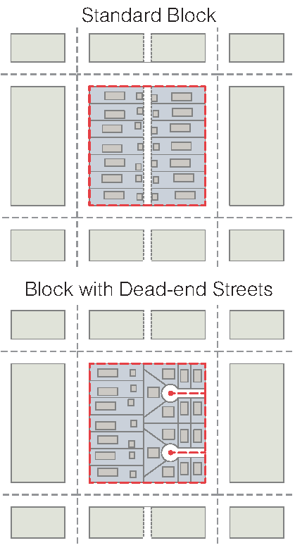
11.3.2. - Blocks
A.
Connectivity Map. The Transportation Master Plan Connectivity Map must first be consulted when designing new development and must be complied with, as determined by the Transportation Director.
B.
Block Perimeters. Where the Transportation Director determines that adequate connections exist, the block standards below do not apply. However, where additional connections are required, the block standards will guide the location of any new connections required by the Transportation Director.
11.3.3. - Block Measurement
A.
A block is bounded by a public or private right-of-way (not including an alley). All public or private rights-of-way proposed as part of a development must be improved with a street (except that in some cases a trail will be on a public or private right-of-way).
B.
Block perimeter is measured along the edge of the property adjoining the public or private right-of-way, except for the measurement of dead-end streets, which are measured from intersecting centerlines.
C.
The Transportation Director may modify the block perimeter requirements when steep slopes in excess of 25%, freeways, waterways, preexisting development, tree protection areas, stream buffers, cemeteries, open space or easements would make the provision of a complete block infeasible.
D.
Where the block pattern is interrupted by public parkland, including greenways, that is open and accessible to the public, pedestrian access points must be provided with a minimum spacing equal to half of the maximum block perimeter.
11.3.4. - Gated Streets
Gated public streets are not allowed. Gates installed on private streets serving more than one lot must comply with the following:
A.
No gate may be installed within public right-of-way;
B.
Plan approval and permit must be obtained prior to installing any gates. Gates must not prohibit public access to any areas dedicated to public use;
C.
Each gate must provide for stacking under Sec. 10.1.13 and emergency vehicle access as required by the City;
D.
Gate permits may be denied by the Transportation Director based on traffic conditions, interconnectivity needs and when not in compliance with the Connectivity Map; and
E.
Gates must be removed if private streets are to become public.
11.3.5. - Lots
A.
Lot Frontage. Every lot must have frontage on a public or private street that meets the requirements of this Article, except for a cottage court.
B.
Lot Dimensions. Lots that are occupied or are intended to be occupied must conform with the lot size, lot width and lot depth requirements provided under Articles 2 through 8.
11.3.6. - Subdivision Access
A.
General.
1.
When land is subdivided, parcels must be arranged and designed so as to allow for the opening of future streets and must provide access to those areas not presently served by streets. No subdivision may be designed to completely eliminate street access to adjoining parcels of land without current street access.
2.
All subdivisions must provide at least one entrance/exit to a public or private street, as determined by the Transportation Director.
3.
The subdivision must provide all necessary easements for ingress and egress for police, fire, emergency vehicles and all operating utilities.
B.
Stub Streets.
1.
Stub Required.
a.
Where a development adjoins unsubdivided land, stub streets within the new subdivision must be installed to the meet the block standards of Sec. 11.3.2.
b.
The stub street right-of-way, pavement and curbing must extent to the boundary of the abutting property to the point where the connection to the anticipated street is expected.
c.
Where a stub street is provided, a barricade using a design approved by the Transportation Director must be constructed at the end of the stub street, pending the extension of the street into abutting property. A sign noting the future street extension must be posted at the applicant's expense.
2.
Connecting to an Existing Stub Street. If a stub street exists on an abutting property, the street system of any new subdivision must connect to the stub street to form a through street.
3.
Exception. The Transportation Director may eliminate the requirement for a stub street or require pedestrian only access when:
a.
Steep slopes in excess of 25%, freeways, waterways, tree conservation areas, stream buffers, cemeteries, open space or easements would make the provision of a stub street infeasible; or
b.
A high intensity nonresidential use is located adjacent to a proposed residential subdivision.
C.
Mobility.
1.
When land is proposed for development or redevelopment requiring a land disturbance permit such proposal shall identify at a minimum 2 access connections to the current City of Roswell Transportation network.
2.
The first access connection shall be as required under this Unified Development Code and/or subdivision development code for vehicular access to a public road.
3.
In addition the development shall provide a second access connection based upon mobility standards.
4.
The mobility standard requirement is measured by the number of trips generated by the development according the International Transportation Engineering (ITE) standards for land use. Single-family residential, townhome and multifamily units are all equated with Office and Commercial Space based upon ADT generated and mobility requirement shall be provided as follows:
a.
First Mobility Priority: The development trip generation exceeds 750 ADT: There shall be a second access connection provided to be constructed as a public road with vehicle, bike and pedestrian elements with access connection to a road that is not the same as the first public right-of-way.
b.
Second Mobility Priority: The development trip generation is between 360 to 750 ADT: The developer shall endeavor to meet first priority but if not a second access connection shall be required to connect with vehicle, bike and pedestrian elements to the same road as the first access but located as far from the first as is possible.
c.
Third Mobility Priority: The development trip generation is between 225 to 360 ADT: The developer shall endeavor to meet first priority or second priority but if not shall provide a second access connection built to support a fire truck with full time pedestrian and bike access and may have either a vehicle gate or removable bollard as long as the fire department is provided an accessible lock.
d.
Fourth Mobility Priority: The development trip generation is less than 225 ADT: The developer shall endeavor to meet first, second, or third priority but if not shall provide a second access connection built to support a fire truck that connects to a multi-use path for bike and pedestrian access.
11.3.7. - Interparcel Access
All nonresidential and multi-family lots abutting another nonresidential or multi-family lot must comply with the following standards.
A.
Internal vehicular circulation areas must be designed and installed to allow for interparcel access between abutting lots.
B.
When an abutting lot is vacant or already developed, a stub for a future interparcel connection must be provided at the point where the connection to the abutting property is expected to occur in the future.
C.
If an interparcel access driveway stub exists on an abutting property, the internal vehicular circulation area must connect to the stub to form an interparcel connection.
D.
When interparcel access for vehicles is deemed impractical by the Transportation Director on the basis of topography, the presence of natural features, or vehicular safety factors, the requirement for interparcel access may be waived. Bicycle and pedestrian connections must be provided between abutting properties when interparcel access is waived.
E.
Property owners who establish interparcel access easements must:
1.
Allow pedestrian and vehicular access to all properties on the same block face as the property owner establishing the interparcel access. Pedestrian and vehicular access is contingent upon the granting of reciprocal vehicular and pedestrian access rights to the granting property;
2.
Record an easement allowing interparcel access to and from properties served by the interparcel access easement;
3.
Record a joint maintenance agreement requiring each property owner to maintain the vehicular and pedestrian access areas on their lot;
4.
Contain a provision prohibiting the erection of fences, walls and other obstructions that prevent the use of vehicular and pedestrian accessways;
5.
Include a statement that the interparcel access agreement is conveyed with the land, is binding on all successors, heirs and assigns and that the easement rights are perpetual; and
6.
The interparcel access agreement must be signed by all of owners of the granting property.
11.4.1. - Intent
A.
The intent of this Section is to provide a palette of street types and design elements that reflect the character of different areas within the City, as referenced in the Transportation Master Plan.
B.
The regulations provide adequate accommodations for vehicles, cyclists and pedestrians.
C.
The City supports the use of context sensitive design solutions and complete streets and will review projects on a case-by-case basis for conformance with these concepts.
D.
The street typical cross-sections displayed in this Section provide a guide to balancing the needs of all modes of travel. Modifications to these typical cross-sections may be made by the Transportation Director.
E.
The appropriate street typical cross-section will be selected by the Transportation Director based on both engineering and land use context factors, including anticipated vehicle volumes.
F.
When installation of sidewalks is required, sidewalks shall meet the definition of a multi-use path in Section 11.4.14.D of the Unified Development Code for parcels with frontage:
1.
Along the following commercial roads: State Highway 9, Crossville Road, and Holcomb Bridge Road.
2.
Along the routes identified as locations for Multi-Use paths, also referred to as spokes or planned spokes as included in the Roswell Bicycle and Pedestrian Master Plan's map titled Roswell Hub and Spoke Cycle and Pedestrian Network Map.
3.
For developments containing multi-family, the multi-use trail shall be located surrounding the development on all street frontages.
(Ord. No. 2018-09-15, § 1, 9-24-2018; Ord. No. 2020-06-06, §§ 1, 2, 6-8-2020; Ord. No. 2020-07-13, § 1, 7-13-2020)
11.4.2. - Applicability
A.
When a Preliminary Plat, Final Plat, Design Plan or Land Disturbance Permit proposes the construction of a new street, the requirements of this Section apply.
B.
When constructing a public or private street or reconstructing an existing street, sidewalks, bike lanes, curb and gutter and street trees must be installed and constructed in accordance with this Section and the Standard Construction Specifications.
C.
Existing streets may continue serving existing development in their current configuration; however, they must not be extended or substantially rebuilt except in conformance with this Section.
D.
All projects in overlay districts must conform to the approved overlay design guidelines for the respective area.
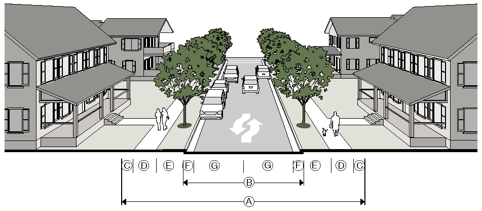
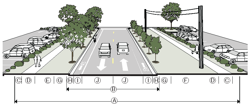
11.4.3. - Street Right-of-Way Width
A.
Street right-of-way width for Major Streets must be dedicated as specified in the Transportation Master Plan or as otherwise required by the Transportation Director.
B.
Applicants must dedicate sufficient right-of-way to the City for streets and sidewalks. Typical street right-of-way widths are illustrated in this Section.
C.
A median may be added to the street cross-sections by increasing the right-of-way width. A median should be 20 feet in width in order to provide for landscaping and turn lanes. In no case will a median less than 6 feet in width be considered.
D.
The Transportation Director may require turn lanes, and additional right-of-way beyond that shown in the applicable street typical cross-section to accommodate these lanes.
11.4.4. - Improvements Along State Highways
A.
For any development that abuts a State highway or other right-of-way controlled by the State of Georgia, improvements to the roadway and the location and design of any street or driveway providing access from the State highway must comply with the standards and requirements of the Georgia Department of Transportation.
B.
An approved permit for proposed access or improvements is required by Georgia Department of Transportation and must be incorporated into the construction drawings for the project prior to the issuance of a Land Disturbance Permit.
11.4.5. - Street Dedication
The Engineer Director, with input from the Transportation Director, must review, inspect and accept for dedication streets and sidewalks constructed in relation to the development of private lands or uses.
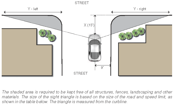
11.4.6. - Visibility at Intersections
A.
Sight Triangle Required. Where a driveway intersects a public or private right-of-way or where property abuts the intersection of two public or private rights-of-way, unobstructed sight distance must be provided at all times within the sight triangle area on the property adjacent to the intersection in order to ensure that safe and adequate sight distance is provided.
B.
Obstruction Prohibited. No structures, fences, landscaping or any other object within the sight triangle area can obstruct or obscure sight distance visibility by more than 25% of the total view in the vertical plane above the sight triangle area between a height of 30 inches and 96 inches above the roadway surface.
C.
Sight Triangle Area. The sight triangle area is:
1.
Driveways. The area formed at a corner intersection of public or private right-of-way and a driveway, whose two sides are 15 feet, measured along the right-of-way line of the street and the edge of the driveway, and whose third side is a line connecting the two sides;
2.
Alleys. The area formed at a corner intersection of an alley public right-of-way and a street right-of-way whose two sides are fifteen feet, measured along the right-of-way line of the alley and the right-of-way line of the street, and whose third side is a line connecting the two sides; or
3.
Streets. The area formed at a corner intersection of two public or private rights-of-way lines defined by a width of dimension X (13 feet) and a length of dimension Y. The Y dimension will vary depending on the speed limit of the intersecting street. The X distance is 13 feet measured perpendicular from the curb line of the intersecting street.
11.4.7. - Street Tree Planting
A.
One shade tree must be planted every 40 feet on center, on average on all streets, as illustrated in this Section. Where overhead utilities exist, one understory tree planted every 20 feet on center, on average, must be substituted for the required shade tree.
B.
All required street trees must meet the design, installation and maintenance requirements of Sec. 10.2.11 and Sec. 10.2.12.
11.4.8. - Private Streets
A.
All private streets must be constructed to equal or exceed the standards for public streets and must be certified by the Engineering Director.
B.
Private streets are not dedicated to the public and will not be publicly maintained.
C.
A Final Plat or Design Plan that contains private streets must clearly state that such streets are private streets.
D.
All private streets must be treated as public street rights-of-way for purposes of determining required development and dimensional standards.
E.
In residential subdivisions where private streets are proposed, the Transportation Director may require a public street for inter-parcel connection and cross-access may also be required.
F.
The Transportation Director will evaluate requests from homeowners association residents for converting a street from public to private or private to public and make a recommendation to approve or disapprove a request as outline by the Private to Public Streets Policy adopted May 12, 2014 as amended from time to time.
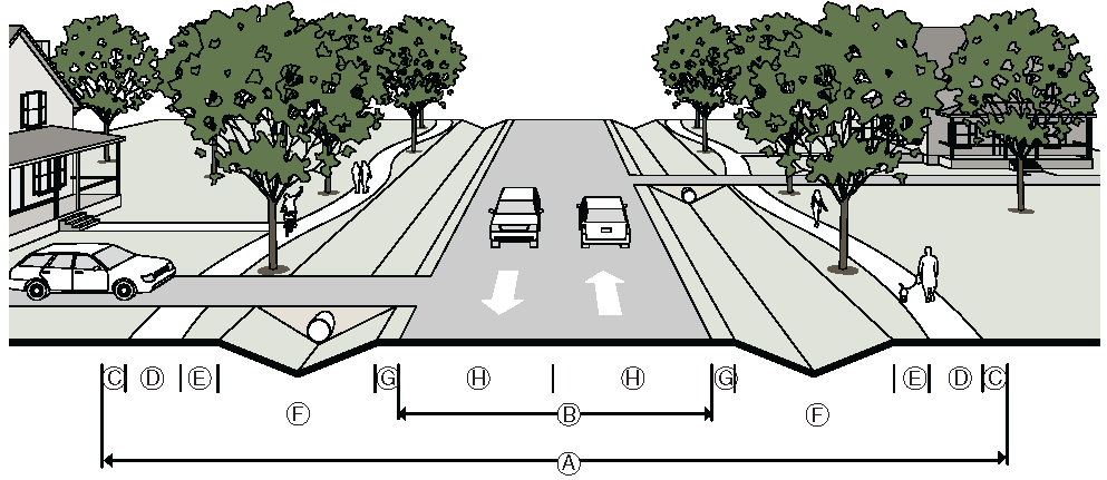
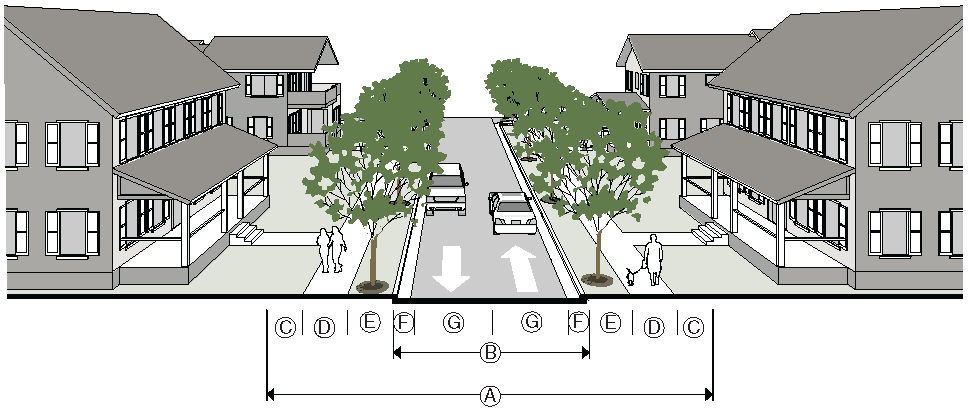
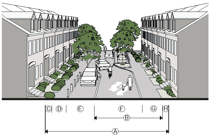
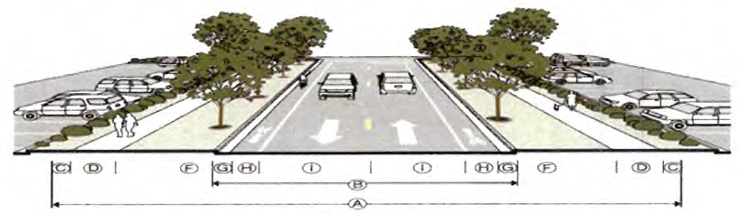
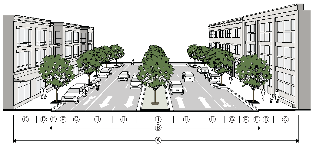
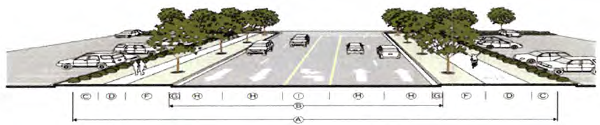
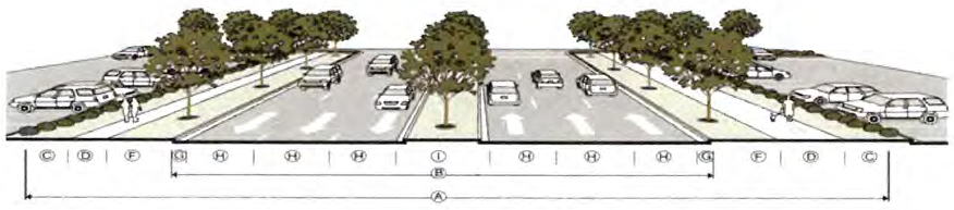
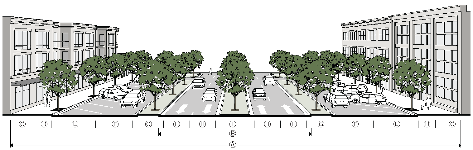
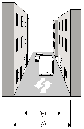
11.4.9. - Street Types
Unless modified by the Transportation Director, all new or extended streets must meet the requirements of the following street types.
A.
Local Streets.
1.
Residential Yield
2.
Residential
3.
Sensitive
4.
Local Street in Historic Overlay District
5.
Woonerf
B.
Collector Streets.
1.
Collector, 2 Lanes
2.
Collector, 2 Lanes, Parallel Parking
C.
Minor Arterials.
1.
Minor Arterial, 3 Lanes, Parallel Parking
2.
Minor Arterial, 4 Lanes, Parallel Parking
D.
Principal Arterials.
1.
Principal Arterial, 5 Lanes
2.
Principal Arterial, 6 Lanes
3.
Multi-way Boulevard
E.
Accessways.
1.
Alley, Residential
2.
Alley, Mixed Use
3.
Pedestrian Passage
4.
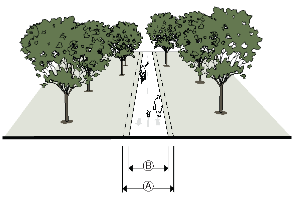
Multi-Use Trail
5.
Service Road
11.4.10. - Local Street
A.
Residential Yield.
>* See UDC 11.4.1 Line F, if Hub & Spoke map corridors may also require 10' sidewalks on one side of street.
B.
Residential.
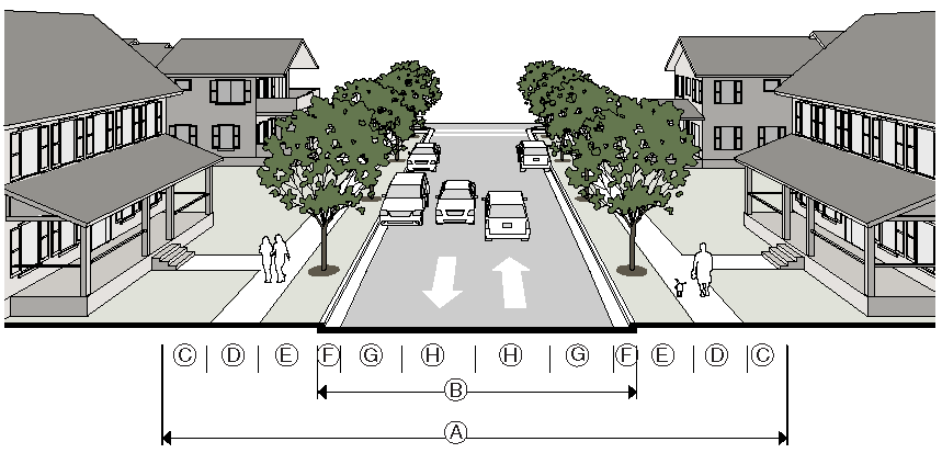
>* See UDC 11.4.1 Line F, if Hub & Spoke map corridors may also require 10' sidewalks on one side of street. Road width may need to be 26' wide (face to face of curb) if building heights (eve or parapet) is 30'+ feet high.
C.
Sensitive.
D. Local Street in Historic Overlay District.
>* See UDC 11.4.1 Line F, if Hub & Spoke map corridors may also require 10' sidewalks on one side of street. Road width may need to be 26' wide (face to face of curb) if building heights (eve or parapet) is 30'+ feet high.
E.
Woonerf.
(Ord. No. 2021-01-03, §§ 1—3, 1-11-2021)
11.4.11. - Collector Streets
A.
Collector, 2 Lanes, No Parking.
>* See UDC 11.4.1 Line F, if Hub & Spoke map corridors may also require 10' sidewalks on one side of street.
B.
Collector, 2 Lanes, Parallel Parking.
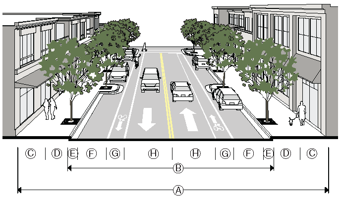
* See UDC 11.4.1 Line F, if Hub & Spoke map corridors may also require 10' sidewalks on one side of street.
(Ord. No. 2021-01-03, §§ 4, 5, 1-11-2021)
11.4.12. - Minor Arterials
A. Minor Arterial, 3 Lanes, Parallel Parking.
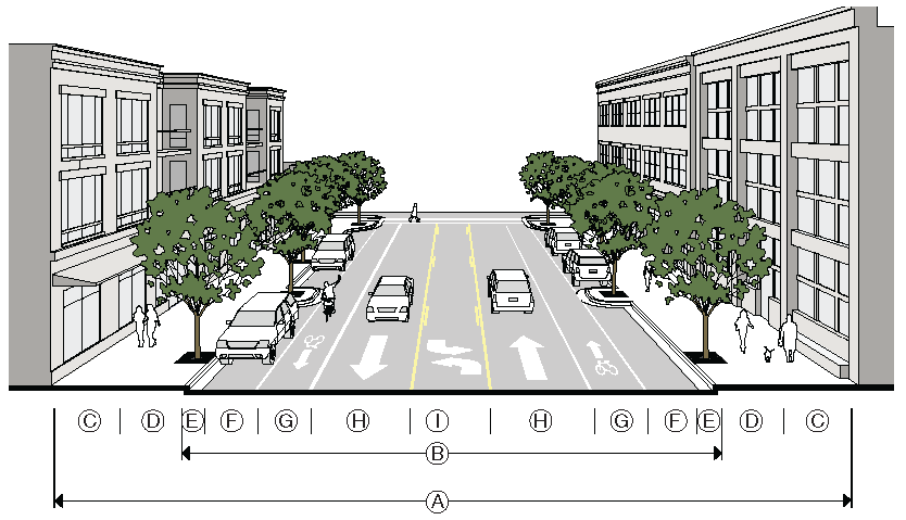
>* See UDC 11.4.1 Line F, if Hub & Spoke map corridors may also require 10' sidewalks on one side of street. Bike lanes are to be 5' wide when parallel parking exist, 4' is acceptable without parallel parking.
B. Minor Arterial, 4 Lanes, Parallel Parking.
>* See UDC 11.4.1 Line F SR-9, Holcomb Bridge Road, Crossville Road required 10' sidewalks, Hub & Spoke map corridors may also require 10' sidewalks on one side of street. Bike lanes are to be 5' wide when parallel parking exist, 4' is acceptable without parallel parking.
(Ord. No. 2021-01-03, §§ 6, 7, 1-11-2021)
11.4.13. - Principal Arterials
A. Principal Arterial, 5 Lanes.
* See UDC 11.4.1 Line F SR-9, Holcomb Bridge Road, Crossville Road required 10' sidewalks Hub & Spoke map corridors may also require 10' sidewalks on one side of street.
B. Principal Arterial, 6 Lanes.
* See UDC 11.4.1 Line F SR-9, Holcomb Bridge Road, Crossville Road required 10' sidewalks, Hub & Spoke Map corridors may also require 10' sidewalks on one side of street.
C. Multi-way Boulevard.
(Ord. No. 2021-01-03, §§ 8, 9, 1-11-2021)
11.4.14. - Accessways
A. Alley, Residential.
B. Alley, Mixed Use.
* If building eve is 30'+ feet high, minimum width would be 26' wide for Fire Department aerial apparatuses.
C. Pedestrian Passage.
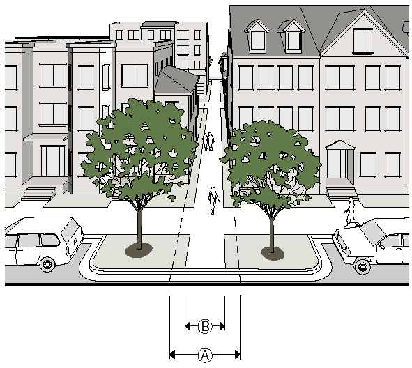
D. Multi-Use Trail.
E. Service Road.
(Ord. No. 2021-01-03, § 10, 1-11-2021)
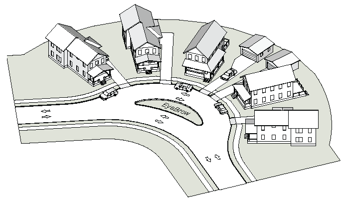
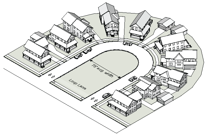
11.4.15. - Dead-End Streets
A.
Dead-end streets are permitted only with the approval of the Engineering Director, the Transportation Director and the Planning Commission. A application must not be submitted to the Planning Commission for review without the approval of both the Engineering Director and the Transportation Director for the dead-end location and configuration.
B.
Dead-end streets that exceed 150 feet in length must provide an adequate turn-around as approved by the Fire Department. Street length is measured from the end of the improved surface to the center of the intersection with the connecting street.
C.
The following alternatives to dead end streets may be approved at the time of subdivision.
1.
Eyebrow. An eyebrow is a rounded expansion of a street beyond the normal curb line. An eyebrow must have a landscaped island.
2.
Loop Lane. A loop lane is a two-way street, no portion of which is more than the maximum allowable dead-end street length. The interior landscaped area is required and must have an average width of 75 feet.
11.4.16 - Existing Streets
A.
Applicability.
1.
A building or site may be renovated or repaired, or reconstructed provided the current owner experienced a fire or natural disaster, without meeting the requirements of this Section, provided there is no increase in gross floor area or improved site area.
2.
When a residential building is increased in gross floor area by more than 1,000 square feet, the streetscape provisions of this Section must be met.
3.
When an accessory structure on a residential lot or parcel is proposed or increased in gross floor area, and the new or added gross floor area is more than 1,000 square feet, the streetscape provisions of this Section must be met.
4.
When a non-residential building or site is increased in gross floor area or improved site area cumulatively by more than 500 square feet, the streetscape provisions of this Section must be met.
B.
Sidewalk and Street Trees Required.
1.
On existing public streets, sidewalks and street trees along the entire lot frontage that do not meet the width and planting standards of Sec. 11.4. must be brought into compliance with the current standards prior to the issuance of a Land Disturbance Permit or Building Permit.
2.
An inspection of the existing sidewalk and street trees will be made by the Transportation Director. If the inspection shows the sidewalk or street trees are substandard or do not exist, the applicant must install the sidewalk and street trees to the current design specifications, including material revisions, such as concrete to brick, as required by the Transportation Director.
3.
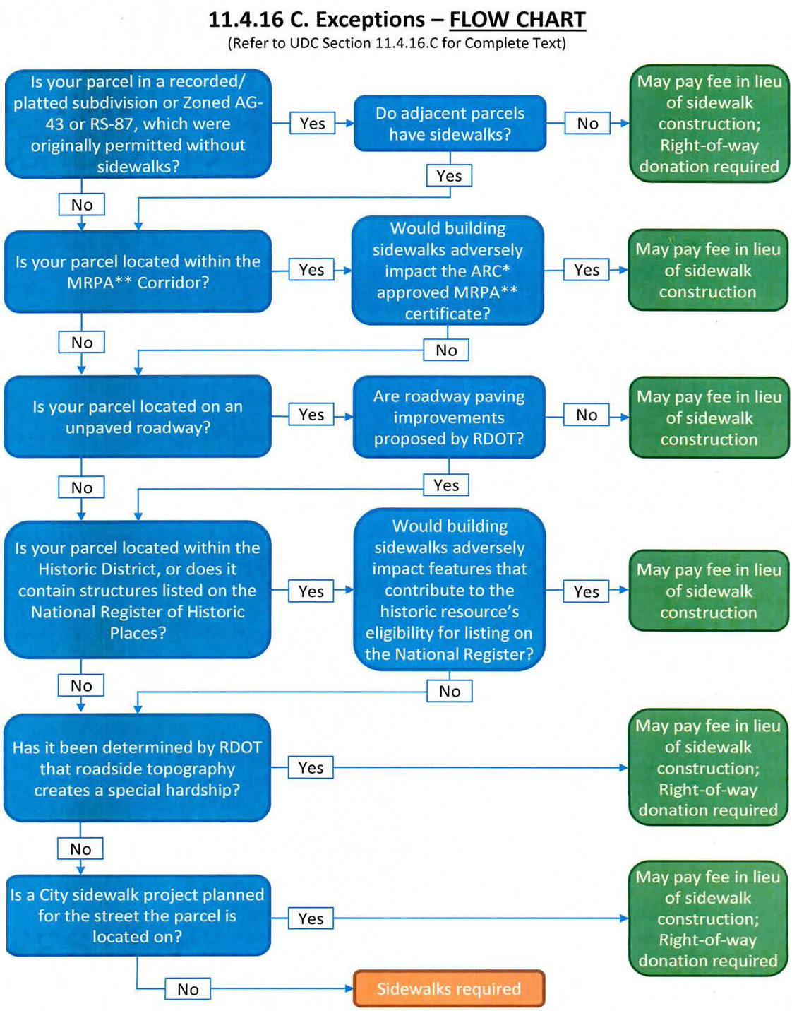
Refer to Sidewalk Construction Flow Chart for application process of Sec. 11.4.16.C. Exceptions.
C.
Exceptions. The following are exceptions to the streetscape provisions of this section that a permit application may request, as applicable:
1.
Parcels located within a recorded/platted subdivision or Zoned AG-43 or RS-87, which were originally permitted without sidewalks and where adjacent parcels do not have sidewalk, would not be required to install sidewalks. Donation of right-of-way would be required to allow for the installation of a sidewalk in the future. Payment to the City of Roswell in lieu of the required installation of the sidewalk and street trees is required; see 11.4.16.C.7. for payment details.
2.
Parcels located within the MRPA Corridor (see Sec. 8.1. -RC: River Corridor Overlay) where construction of sidewalks would adversely impact the ARC approved MRPA Certificate would not be required to install sidewalks or donate right-of-way for future sidewalk installation. Payment to the City of Roswell in lieu of the required installation of the sidewalk and street trees is required; see 11.4.16.C.7. for payment details.
3.
Parcels located on unpaved roadways where there is no paving improvement proposed by the Transportation Department would not be required to install sidewalks or donate right-of-way for future sidewalk installation. Payment to the City of Roswell in lieu of the required installation of the sidewalk and street trees is required; see 11.4.16.C.7. for payment details.
4.
Parcels located within the City of Roswell Historic District, as adopted by Mayor and City Council April 13, 2013, that contain historic structures, or are listed on the National Register of Historic Places, and where construction of sidewalks would adversely impact features that contribute to the historic resource's eligibility for listing on the National Register of Historic Places in accordance with requirements of the State Historic Preservation Office would not be required to install sidewalks or donate right-of-way for future sidewalk installation. Payment to the City of Roswell in lieu of the required installation of the sidewalk and street trees is required; see 11.4.16.C.7. for payment details.
5.
Where the Transportation Director determines the topography of the roadside is such that a special hardship exists on a single-family residential property, payment to the City of Roswell in lieu of the required installation of the sidewalk and street trees may be authorized. Donation of right-of-way would be required to allow for the installation of a sidewalk in the future.
6.
Along public streets where a City sidewalk project is included on the Sidewalk Priority Matrix or has been awarded for construction, the Transportation Director may accept payment to the City of Roswell in lieu of the required installation of the sidewalk and street trees where in his opinion the acceptance of funds would be appropriate. Donation of right-of-way would be required to allow for the installation of a sidewalk in the future.
7.
Any payment in lieu of the installation of the sidewalk and street trees must be in an amount determined by the Transportation Director. The amount would be based on present day cost to install the sidewalk in accordance with the width standards of Sec. 11.4.
8.
The funds received must be deposited in an account of the City of Roswell and restricted to use for the installation of sidewalks and street trees anywhere in the City.
(Ord. No. 2017-10-10, § 1, 10-9-2017; Ord. No. 2021-03-07, § 1, 3-8-2021)
11.4.17. - Traffic Calming Measures
Where residential streets are longer than 600 feet, traffic calming devices may be required by the Transportation Director. These measures may include green space, median islands, roundabouts and or other traffic calming devices.
11.4.18. - Personal Transportation Vehicles
The City permits Personal Transportation Vehicles on local roads and multi-use trails. Every effort should be made to accommodate these vehicles into the design and lay-out.
11.5.1. - Required Improvements Generally
A.
To facilitate the efficient and adequate provision of transportation, water and sewer and to secure public safety, every subdivision and site plan is subject to a determination of the sufficiency of infrastructure.
B.
Infrastructure is considered sufficient when it is demonstrated to have capacity to accommodate the demand generated by the proposed development.
C.
Every applicant is required to install all improvements and utilities (or provide surety for the installation, where applicable), as indicated on approved plans and specifications, before lots can be sold.
D.
If the internal roadway network within a development is substandard, it must be brought up to City standards prior to issuance of any Certificate of Occupancy.
11.5.2. - Compliance and Completion of Improvements
A.
Letter of Approval. Signature by the Engineering Director on the Final Plat indicates substantial completion and approval of the required provisions of this UDC.
B.
Inspection. All underground installations, subgrades, bases or courses of asphalt must not be covered or hidden before they are inspected and accepted by the Engineering Director.
C.
Certification. All improvements required under this UDC must be installed by a person, firm or corporation competent, qualified, licensed and bonded to do such work.
11.5.3. - Design of Utilities and Other Improvements
A.
All utility systems, including water, sewerage, gas and electric, along with component parts, structures, appendages and materials, must be designed to City of Roswell, Fulton County or other applicable standards and be approved by the Public Works Director and Engineering Director.
B.
All utility systems must be installed underground. Above-ground utility systems will not be permitted, except where certain appurtenances and accessories must be installed above-ground for servicing.
C.
All subdivisions shall meet the stormwater requirements of the City of Roswell. When serving more than three lots, detention ponds, (including all required access easements, landscape strips and fences) must be located on an individual lot of record where no home can be constructed. This parcel must be owned and maintained by the homeowners association or the lots of record being served by this facility. The parcel must have a minimum 20-foot wide continuous access to a public or private road in a manner that allows access and maintenance of this parcel. This lot will not be required to meet the normal lot standards for that zoning district. Water Quality treatment facilities (such as bioretention ponds) need not be located on an individual lot of record, however a drainage easement shall be applied to the water quality facility and the facility shall be maintained by the homeowners association or the lots of record being served by this facility.
D.
For all development or redevelopment that requires detention ponds, retention ponds or water quality features, such features must be located outside any required buffer.
E.
Underground detention ponds are allowed under public roadways when approved by the Transportation Director with input from the Public Works Director.
11.5.4. - Fulton County Septic Tank Requirements
A.
The minimum lot size required for considering approval of installation of an on-site sewage management system serving a single residence is 43,560 square feet of usable area and must accommodate the initial system and the reserve area.
B.
The reserve area must remain undisturbed, available for future repair, must not conflict with applicable zoning requirements and must not be used to accommodate any other construction (aboveground or underground) precluding its use or availability in the event of initial-system failure.
C.
Development on individual lots with less than 43,560 square feet of usable area are restricted to those served by public or community sewerage systems.
11.6.1. - Intent and Purpose
A.
The intent of this Section is to comply with the Development Impact Fee Act (O.C.G.A. Title 36, Chapter 71), as amended.
B.
The purpose of this Section is to provide procedures and standards for payment of impact fees so that land development bears a proportionate share of the cost of expanded or new system improvements. The assessment of impact fees correlates with public facilities identified in the Capital Improvement Element. Impact fees are collected for public safety, recreation and parks and transportation facilities.
11.6.2. - Impact Fee Required
A.
Any person who engages in a "development activity" must pay an impact fee in the manner and amount established by this ordinance.
B.
Impact fees must be collected at the time of the issuance of a building permit.
C.
Impact fees shall be calculated at the time of the issuance of a building permit based on the current impact fee schedule in place at that time.
11.6.3. - Computation of Impact Fees
The impact fee assessment will be through an individual fee determination or in accordance with the methodology report. Computation in accordance with Sec. 11.6.4, the methodology report must be as follows:
11.6.4. - Development Impact Fee Computation
11.6.5. - Individual Fee Determination
A.
If a developer must elect not to have the impact fee determined according to this Section, then pursuant to O.C.G.A. § 36-71-4(g) the developer may apply for an individual fee determination. A developer applying for an individual fee determination must prepare and submit to the Administrator an individual fee calculation study for the development activity for which a building permit is sought. The individual fee calculation study must follow the methodology and format of the "methodology report" or subject to prior approval of the Administrator, such other professionally accepted methodology that identifies a project's proportionate share.
B.
The developer must attend a pre-application meeting with the Administrator, and no agreement or understanding in regard to data assumptions or methodology will be binding upon the City unless specifically agreed to by the City in writing. The documentation submitted must show the basis upon which the individual fee calculation was made.
C.
The Administrator must provide the developer with the individual fee determination within 30 days after presentation of the individual fee calculation study.
11.6.6. - City Fee Determination
In the sole discretion of the Administrator, the City of Roswell staff may undertake an individual fee study on behalf of the applicant. In the event the staff does not find cause for a fee adjustment, the applicant must pay the impact fee in accordance with the fee schedule or the applicant may elect to undertake an individual fee calculation study pursuant to this Section.
11.6.7. - Application for Certification of Impact Fee
Upon application to the Administrator, any person contemplating development activity requiring payment of an impact fee may apply for and must receive from the Administrator a certification of the impact fee schedule or a certification of an individual fee determination. Applications for certification must include the following information and items:
A.
A full and complete description of the project;
B.
A full and complete description of the proposed land use and development activity;
C.
A statement as to whether the applicant seeks a certification of the impact fee schedule or a certification of an individual fee determination; and
D.
If the applicant seeks a certification of an individual fee determination, an individual fee calculation study complying with the requirements of Sec. 11.6.5.
11.6.8. - Procedures for Certification
A.
The Administrator must provide an applicant with a written certification of the impact fee schedule within 5 working days after the Administrator's receipt of a completed application. The fee schedule certified by the Administrator will establish the impact fee schedule for the proposed development activity for a period of 180 days from the date of certification. The Administrator will provide the applicant with a written certification of an individual fee determination within 30 days after receipt of a completed application.
B.
The individual fee determination certified by the Administrator will establish the impact fee for the proposed development activity for the 180-day period immediately following the date of such certification. Notwithstanding the issuance of any such certification, any changes in or additions to the proposed development activity different from the development activity identified in the original application will be subject to increased or additional impact fees to the extent that such changes or additions require capital improvements or facilities expansions. The additional impact fees will be based upon the impact fee schedule in effect at the time of any such change or addition.
11.6.9. - Additional Requirements
A.
Notwithstanding any other provision of this Section, prior to engaging in development activity and in addition to any other applicable requirements, the developer must certify in writing to the Administrator:
1.
A full and complete description of the project;
2.
A full and complete description of the proposed land use or uses; and
3.
A statement of the gross square footage applicable to each category of land use.
B.
Prior to the completion of the project, and as a condition to the issuance of a certificate of occupancy, the developer must recertify in writing to the Administrator the actual land use or uses of the project, and must present an architect's certificate of the actual gross square footage attributable to each use. In the event that the actual land use or uses and/or the actual gross square footage applicable to the actual land use or uses differs from that originally certified, and in the event that the impact fee applicable to the actual land use or uses and/or gross square footage exceeds the impact fee previously paid, the developer will be required to pay the amount of the excess as a condition to the issuance of a certificate of occupancy. The amount of the excess will be based upon the impact fee schedule in effect on the date the certificate of occupancy is issued. If the actual gross square footage constructed after the issuance of the building permit is less than the amount originally certified, the developer will be entitled to a refund of the excess portion of the fee.
11.6.10. - Payment of Impact Fees
A.
Any person required to pay impact fees pursuant to this Section must pay such fees to the Administrator prior to the issuance of a building permit unless the City has previously approved a private development agreement providing for an alternative method of payment.
B.
All funds collected pursuant to this Section must be properly identified by the impact fee service area from which it was collected and promptly transferred for deposit into the appropriate impact fee trust fund to be held in separate accounts as provided for in this Section. Funds must be used solely for the purposes specified in this Section.
C.
In lieu of all or part of the impact fee, the City may accept an offer to provide the items and/or services specified in this Section. Any such offer must comply with the requirements of the Sec. 11.6.12 The portion of the fee represented by facility improvements will be deemed paid when the construction is completed and accepted by the City or when the person claiming such credit posts security for the cost of such construction as provided in the Sec. 11.6.12 The portion of the fee represented by land dedication will be deemed paid when the title to said land has been accepted by the City.
11.6.11. - Use of Funds
A.
Funds collected as impact fees must be used for system improvements. No funds may be used for periodic or routine maintenance or for any purpose not in accordance with the requirements of O.C.G.A. § 36-71-8.
B.
Impact fees must be used exclusively for system improvements in the service area in which the project for which the fees were paid is located.
C.
Funds must be expended in the order in which they are collected.
D.
Each fiscal period the City of Roswell Finance Director must present to the Mayor and City Council an annual report describing the amount of impact fees collected, encumbered and used during the preceding year. Monies, including any accrued interest, not encumbered in any fiscal period will be retained in the same impact fee trust fund(s) until the next fiscal period except as provided in Sec. 11.6.14.
E.
The City will be entitled to retain up to 3% of all impact fees it collects as an administrative fee to offset the costs of administering this Section.
F.
Impact fees may be used for the payment of principal and interest on bonds, notes or other financial obligations issued by or on behalf of the City to finance system improvements.
11.6.12. - Credits
When eligible, fee payers will be entitled to a credit against impact fees otherwise due and owing under the circumstances and in the manner set forth in this Section.
A.
Except as provided in Sec.11.6.12.B. below, no credit will be given for construction, contribution, or dedication of any system improvement or funds for system improvements made before the effective date of this Section.
B.
If the value of any construction, dedication of land, or contribution of money made by a developer (or his predecessor in title or interest) for system improvements that are included among the improvements constituting the amount of an impact fee assessment (the impact fee project listing), prior to the effective date of this Section or amendment thereto, is greater than the impact fee that would otherwise have been paid for the project, then the developer will be entitled to a credit for such excess construction, dedication, or funding. Notwithstanding anything to the contrary in this Section, any credit due under this Section will not constitute a liability of the City of Roswell and will accrue to the developer to the extent of impact fees assessed for new development for the same category of system improvements within the same service area.
C.
In no event will credit be given for project improvements.
D.
Credit will be given for the present value of construction of any portion of a project that is included in the impact fee project listing, or for the contribution or dedication of land or payment of money for such project, by a developer (or their predecessor in title or interest) for system improvements of the same public facilities category and in the same service area for which a development impact fee is imposed, provided that the City Administrator must have explicitly approved the granting of such credit for the improvement, contribution, dedication, or payment and the value thereof prior to its construction, dedication, or transfer.
E.
Developers who, following the approval of the City of Roswell, construct system improvements for which impact fees would otherwise be imposed and which are included in the impact fee project listing, will be entitled to a credit. The credit allowed pursuant to this Section will be equal to the present value of the cost of construction of the system improvement, up to a maximum of the impact fee due for such system improvement. In the event that a developer enters into a private agreement with the City of Roswell to construct, fund, or contribute system improvements such that the amount of the credit created is in excess of the impact fee which would otherwise have been paid for the development project, the developer must be reimbursed for such excess construction, funding, or contribution from impact fees paid by other development located in the service area which is benefited by such improvements.
F.
For the construction of any system improvements by a developer or his predecessor in title or interest and accepted by the City of Roswell, the developer must present evidence satisfactory to the Administrator of the original cost of the improvement, from which present value may be calculated. A person proposing credit for system improvements must present cost estimates and property appraisals prepared by duly licensed and qualified professionals to be used by the Administrator in determining the amount of the credit. All construction must be carried out in accordance with applicable City, County or State development and design standards.
G.
For any contribution or dedication of land for system improvements by a developer or his predecessor in title or interest and accepted by the City of Roswell, the original value of the land must be the same as that attributed to the property by the validated tax appraisal at the time of dedication, from which present value may be calculated.
H.
For any contribution of capital equipment that qualifies as a system improvement by a developer or his predecessor in title or interest and accepted by the City of Roswell, the value must be the original cost to the developer of the capital equipment or the cost that the City of Roswell would normally pay for such equipment, whichever is less.
I.
For any contribution of money for system improvements from a developer or his predecessor in title or interest accepted by the City of Roswell, the original value of the money must be the same as that at the time of contribution, from which present value may be calculated.
J.
In making a present value calculation, the discount rate used must be the net of the interest returned on a State of Georgia, AA rated or better municipal bond less average annual inflation, or such other discount rate as the Mayor and council in its sole discretion may deem appropriate.
K.
Credits will be given only upon written request of the developer to the City of Roswell. Credits must be claimed at the time of the application for a building permit. Any credit not so claimed will not be available as to any impact fee owing with respect to that building permit.
L.
In the event that an impact fee is paid but the building permit is abandoned, credit will be given for the present value of the impact fee against future impact fees for the same parcel of land, upon submission of adequate evidence to the Administrator that an impact fee was received by the City of Roswell, the amount paid, and that the building permit was abandoned. Such credit will be given upon issuance of the subsequent building permit. A building permit will be deemed abandoned if no construction has been commenced prior to the expiration of the building permit.
M.
Security in the form of a performance bond, or escrow agreement must be posted with the City, made payable to the City in the amount approved by the Administrator equal to 110% of the full cost of the construction of such improvements. If a facility construction project will not be constructed within one year of the acceptance of the offer by the City, the amount of the security must be increased by 10% compounded, for each year of the life of the security. The security must be reviewed and approved by the City Attorney's office prior to the acceptance of the security by the City.
N.
Credits must be represented by a written certificate (the "credit certificate") setting forth the name of the person or entity to whom the credit certificate is issued, the number of the credit certificate, and the amount of the credit. Each credit certificate must be numbered in the order in which it is issued, and must be signed, either manually or facsimile, by the City Finance Director with the seal of the City affixed thereto. The City must also maintain a register (the "credit certificate register") which sets forth the name of the credit holder, the number of the credit certificate, the amount of the credit, and the name of any party entitled to the credit represented by the credit certificate.
O.
The interest of a secured party will not be effective and will not be recognized by the City unless and until the City is in receipt of a written document satisfactory to the City signed by the secured party and the holder of the credit certificate verifying the creation of the security interest and directing the City to enter the secured party's name in the credit certificate register. Credits are transferable from one developer to another and from one project to another provided that such credits must not be transferred to a project in a different impact fee service area, and provided further that the transfer is accomplished in accordance with the provisions of this Section.
P.
Transfers of credit certificates will only be effective when entered in the credit certificate register of the City upon surrender of the credit certificate signed and dated as of the date of the purported transfer by the person in whose name the credit certificate is registered or on his behalf by a person legally authorized to so sign. Any attempted transfer not in compliance with the terms of this Section will not be effective, will not be recognized by the City, and will result in the waiver and forfeiture of the credit. If the credit certificate to be transferred is subject to a security interest reflected in the credit certificate register, the surrendered credit certificate must also be accompanied by a written consent to transfer or release of security interest signed by the secured party. Upon compliance with the transfer provisions of this Section, the City will issue a new credit certificate in the name of the authorized transferee.
11.6.13. - Exemptions
A.
The following are exempted from payment of impact fees:
1.
Alteration or expansion of an existing building or use of land where no additional living units are created, where the use is not changed, and where no additional demand for system improvement facilities will result.
2.
The construction of accessory buildings or structures which will not result in additional demand for system improvement facilities.
3.
The replacement of a building or structure that was in place on the effective date of this Section, or the replacement of a building or structure that was constructed subsequent thereto and for which the correct impact fee had been paid or otherwise provided for, with a new building or structure of the same use, provided that no additional vehicular trips will result.
4.
All or part of a particular project determined by the City Council as constituting economic development, as defined herein.
5.
All or part of a particular project which constitutes affordable housing, as defined in this Section.
B.
A person claiming exemption(s) pursuant to 1., 2. or 3. above must submit to the Administrator information and documentation sufficient to permit the Administrator to determine whether such exemption claimed is proper, and, if so, the extent of such exemption.
C.
A person seeking exemption under paragraph 4. above must submit to the City Council information and documentation sufficient to permit the City Council to determine whether such exemption claimed is proper, and, if so, the extent of such exemption.
D.
Exemptions must be applied for at the time of the application for a building permit except in the case of a private development agreement. Any exemptions not so applied for will be deemed waived.
11.6.14. - Refunds
Refunds of impact fees will be made only in the following instances and in the following manner:
A.
Upon application to the Administrator by the feepayor, the City will refund 97% of the impact fee paid if capacity is available and service is denied. The City will retain 3% of the fee paid as an administrative fee.
B.
Upon application to the Administrator by the feepayor, the City will refund 97% of the impact fee paid and not expended or encumbered if the City, after collecting the fee when service is not available, has failed to encumber the fee or commence construction within 6 years from the date the impact fee was paid. The City will retain 3% of the fee paid as an administrative fee. In determining whether impact fees have been expended or encumbered, fees will be considered encumbered on a first-in, first-out (FIFO) basis.
C.
When the right to a refund exists due to a failure to encumber impact fees, the City must provide written notice of entitlement to a refund to the feepayor who paid the impact fee at the address shown on the application for development approval, or to a feepayor's successor in interest who has given the City notice of the transfer or assignment of the right or entitlement to a refund and who has provided the City a mailing address. The City must also publish such notice within 30 days of the expiration of the 6-year period after the date the impact fee was paid. The published notice must contain the heading "notice of entitlement to development impact fee refund."
D.
A refund application must be made to the Administrator within one year from the date such refund becomes payable under this Section or within one year from the date of publication of the notice of entitlement of a refund as provided under this Section, whichever is later. Any refund not applied for within said time period will be deemed waived.
E.
A refund application must include information and documentation sufficient to permit the Administrator to determine whether the refund claimed is proper, and, if so, the amount of such refund.
F.
A refund will include a pro rata share of interest actually earned on the unused or excess impact fee paid.
G.
All refunds will be paid within 60 days after the Administrator determines that such refund is due.
11.6.15. - Review of Fee Structure
The impact fee structure must be reviewed by the Mayor and the City Council annually; provided, however, the failure to review such structure does not invalidate this Section.
11.6.16. - Impact Fee Service Areas Established
The geographic limits of the City of Roswell comprise one service area for collection of impact fees relating to public safety, recreation and parks, and transportation facilities.
11.6.17. - Impact Fee Trust Funds Established
A.
There are hereby established separate public safety, recreation and parks, and transportation impact fee trust funds, and impact fees collected pursuant to this UDC must be deposited in the appropriate new trust fund.
B.
Funds must be deposited and maintained in one or more interest bearing accounts. Interest earned on funds must be funds of the account on which it is earned and is subject to all restrictions imposed by Section "Use of Funds" of this Section.