
Roswell City Zoning Code
ARTICLE 12
- ENVIRONMENTAL PROTECTION
Sec. 12.2. - Stream Buffer Protection[1]
Editor's note— Ord. No. 2020-06-07, § 1, adopted Dec. 14, 2020, repealed the former Sec. 12.2, §§ 12.2.1—12.2.15, and enacted a new Sec. 12.2 as set out herein. The former Sec. 12.2 pertained to Stream Buffers and derived from the original Code.
Sec. 12.5. - Stormwater Management[2]
Editor's note— Ord. No. 2020-06-07, § 1, adopted June 8, 2020, repealed the former Sec. 12.5, §§ 12.5.1—12.5.6, and enacted a new Sec. 12.5 as set out herein. The former Sec. 12.5 pertained to similar subject matter and derived from the original Code.
12.1.1. - General Provisions
A.
Purpose and Intent. The purposes of the following tree protection requirements are to:
1.
Provide standards for the preservation of trees as part of the land development process;
2.
Protect trees during construction and land development whenever possible in order to enhance the quality of life within Roswell;
3.
Protect specimen trees while providing for reasonable use of land; and
4.
Promote a healthy urban forest.
B.
Applicability
1.
The tree protection requirements of this UDC apply to any activity that requires a review under Article 13, except as specifically exempted in Sec. 12.1.1.C. below.
2.
No Land Disturbance Permit may be issued until it is determined that the proposed development conforms with the tree protection requirements of the UDC.
3.
No person may remove, cause to be removed, poison, damage, trim or transplant any tree with a trunk diameter of 3 inches in diameter at breast height (DBH) which normally attains a mature height of 15 feet or more without first obtaining a permit as provided in this UDC.
C.
Exemptions. The tree protection requirements that protect specimen trees apply to all properties. While the following activities are exempt from the remaining tree protection provisions, a tree removal permit application is required to demonstrate the exemption applies.
1.
The removal of trees other than specimen trees from any lot of less than I acre in size and which contains or is zoned and platted or to be platted for purposes of constructing a detached house or attached house.
2.
The removal of trees from horticultural properties such as farms, nurseries, orchards or tree harvesting.
3.
The removal of trees by a utility company within dedicated utility easements, where necessary to install, remove, repair, or maintain utilities within the easement.
4.
The removal of trees on public rights-of-way by or on behalf of any federal. state, county, municipal, or other government agency with jurisdiction, where necessary to lawfully construct, maintain, repair or improve public rights-of-way.
5.
The removal of trees, other than specimen trees, from detention ponds and drainage easements where necessary for the construction, maintenance, or operation of detention ponds or drainage improvements within drainage easements.
6.
The removal of any tree which has become or threatens to become a danger to human life or property, as determined by the City Arborist.
7.
The removal of trees less than 3 inches DBH where no Land Disturbance Permit is required.
(Ord. No. 2019-08-28, § 1, 8-26-2019)
12.1.2. - Tree Protection Survey and Plan
A.
Tree Survey Required
1.
Survey Required. A tree survey must be submitted to the City Arborist as part of any application that requires review under Article 13.
2.
Survey Requirements. The tree survey must be in the form of a map drawn to scale or a site plan prepared and sealed by a registered land surveyor, registered professional engineer, registered landscape architect, an arborist certified by the International Society of Arboriculture, or a registered forester.
3.
Natural Features. Important natural features such as streams, stream buffers and wetlands must be shown on the tree survey.
4.
Specimen Trees. All specimen trees and their critical root zones and drip lines must be labeled, even if the tree trunk is not on the subject property, and must be shown on the tree survey and inventoried by size and species. This includes specimen trees to be preserved as well as those proposed for removal, if any, and the portion of critical root zones and drip lines of trees on abutting properties which are contained within the subject property, to the extent that drip lines and critical root zones can be determined from the vantage point of the property to be developed. This provision does not authorize trespassing on private property abutting the site.
5.
Other Trees To Be Retained. All other trees to be counted toward meeting tree density unit requirements must be shown on the survey and inventoried by size and species. Only trees of 3 inches DBH or greater are eligible for tree density unit compliance purposes. Trees to be retained must be designated as tree save areas, including their drip line and critical root zones.
6.
Trees To Be Removed. Trees other than specimen trees that are proposed to be removed are not required to be counted and shown individually on the tree survey. Such trees may be estimated in number, size and species and quantified as part of the total site inventory of tree population.
7.
Sampling. Sampling methods may be used to determine tree densities for forested areas over 2 acres with approval of the City Arborist.
8.
Tree Save Areas. All tree save areas must be delineated on the tree survey. All buffers with existing trees must be delineated as tree save areas. Land disturbance within any buffer must be approved by the City Arborist.
9.
List and Tree Density Unit Calculations. The tree survey must provide an accurate list of trees to be saved and their tree density units.
B.
Tree Survey Inspection. Within 10 working days following the receipt of a tree survey, the City Arborist will conduct an inspection of the proposed development site. The applicant will be advised as to the date and time of the inspection and given an opportunity to attend and observe the inspection. Following inspection, the City Arborist will advise the applicant in writing or on the survey of any recommended changes to the applicant's tree survey.
C.
Tree Protection Plan Required. A tree protection plan must be submitted to the City Arborist as part of any application that requires review under Article 13.
D.
Tree Protection Plan Specifications. A tree protection plan is a detailed plan designed to protect and preserve trees before, during and for a period of 2 years after issuance of a Final Certificate of Occupancy, including the following:
1.
Separate Drawing. The tree protection plan must be submitted as a separate drawing unless the City Arborist approves the combination of tree protection plan with a tree replacement plan on a single drawing.
2.
Boundary Survey. The tree protection plan must be submitted on a current boundary survey of the proposed site, drawn to scale, and clearly show all information required in this paragraph.
3.
Tract Identification. The plan must identity the tract of land involved by acreage and location.
4.
Owner and Contact. The name, address and phone number of the owner of the land and the name, address and phone number of any tenant of the property, and 24-hour emergency contact phone number
5.
Trees To Be Protected. The type, location and size in DBH of all trees to be protected. Only trees designated on the approved tree protection plan will be counted toward meeting the minimum required tree density requirements.
6.
Specimen Trees. Location, species, size, critical root zone, and drip line for specimen trees proposed to be protected or removed. Where a critical root zone or drip line for a tree on abutting property is proposed to be protected, it must be included in the tree protection plan.
7.
Tree Save Areas and Clearing Limits. All natural areas to be retained and buffers must be included in a tree save area.
8.
Tree Protection Methods. Methods of tree protection for all tree save areas, including tree fencing, erosion control, retaining walls, tunneling for utilities, aeration systems, transplanting, staking, signage, geoweb or similar material, permeable paving, bollards, and similar methods, must be included in the tree protection plan.
9.
Development Characteristics. The plan must identify the location of roads, existing and proposed structures, paving, driveways, cut and fill areas, drainage before and after construction including detention areas, and similar aspects of the proposed project that may affect tree protection.
10.
Justification for Removal. Provide a written explanation as to why specimen tree(s) cannot be retained on the site in accordance with Section 12.1.3 Tree Removal.
11.
Utilities and Easements. The plan must include the location of all existing and proposed utility lines or easements, including the location of any boring sites for underground utilities.
12.
Tree Density Units. Calculations showing the trees to be retained to meet minimum required tree density units must be included in the plan.
13.
Irrigation Systems. The tree protection plan must indicate any irrigation systems.
14.
Additional Information. Additional information may be required on a case-by-case basis by the City Arborist.
E.
City Arborist Authority. As part of a tree protection plan, the City Arborist may require relocation or replacement of trees as uniformly as possible throughout the site. The City Arborist may also require the use of active tree protection fencing for any or all tree save areas.
(Ord. No. 2019-08-28, § 1, 8-26-2019)
12.1.3. - Tree Removal
A.
Applicability
1.
The tree removal provisions apply to any person removing trees, as well as any person removing trees on behalf of any other person, including all tree removal companies, utility companies or persons in the business of removing trees or construction.
2.
It is unlawful for any person or company to remove any tree or undertake any work for which a Land Disturbance Permit is required unless a valid permit is in effect and displayed on the site.
3.
Where any such work or removal is performed without the permit being displayed, the removal or work constitutes a violation and will subject the person or company violating this UDC in accordance with Sec. 13.14.
4.
Utility companies may conduct emergency work without formal approval; provided, however, that emergency actions are reported in writing to the City Arborist within 3 working days after completion of all emergency services. Further, the permit taken by any person, company or utility may include defined areas of tree cutting and trimming under one permit.
B.
Removal of Specimen Trees. No specimen tree may be removed except in accordance with the following requirements.
1.
Justification for Removal. Any applicant proposing to remove a specimen tree must apply for a tree removal permit. In addition to the requirements for tree removal permits, the applicant must provide a written explanation as to why the specimen tree cannot be retained on the site. This description must include a description of alternative site plans considered to avoid the removal of the specimen tree. The written explanation must at minimum include the following:
a.
Consideration of whether any buildings or structures, parking areas, stormwater facilities, utilities, driveways, or other features of the proposed development can be relocated or designed to retain the specimen tree, and the additional costs of redesign, if any.
b.
Consideration of whether the land area consumed by the proposed development can be reduced via decked parking, reduction of the footprint of a building or structure by increasing the height or number of stories, placement of stormwater facilities underground. and other appropriate means, to retain the specimen tree, and the additional costs involved in the surface area modifications, if any.
2.
Engineering Director Approval. The Engineering Director will approve or deny the application to remove a specimen tree, after review and recommendation from the City Arborist. The Engineering Director may issue a permit to remove one or more specimen trees after finding that one or more of the following conditions are met:
a.
The written analysis provides convincing evidence that alternative site and building designs have been considered by the applicant, but would not result in retention of the specimen tree.
b.
The additional cost associated with developing the site or constructing buildings as redesigned or reducing the site area consumed to retain one or more specimen trees would be disproportional to the value of the specimen tree retained, calculated at $100 per tree density unit.
c.
Where more than one specimen tree is proposed to be removed, the site design results in the minimum number of specimen trees removed that are necessary to accommodate the proposed development.
d.
The request to remove one or more specimen trees is reasonable considering the remaining specimen trees on the site that will be retained.
e.
A variance to the district dimensional requirements may be an appropriate remedy to preserve a specimen tree. Where, in the opinion of the Zoning Director, one or more variances would enable a site and building design to be accomplished while saving one or more specimen trees, and where the objectives of tree protection would outweigh the purposes of the dimensional requirements that would be varied, the Zoning Director may suggest an applicant apply for variances instead of proposing to remove one or more specimen trees. A determination by the Zoning Director that one or more variances to the dimensional requirements would not be appropriate may support a finding by the Zoning Director in favor of granting approval to remove one or more specimen trees.
3.
Fee in Lieu of Specimen Tree Preservation
a.
If removal of a specimen tree is approved by the Engineering Director, then prior to issuing the tree removal permit, the applicant must contribute to the Roswell Tree Bank an amount of $500 for each tree density unit of the specimen trees removed.
b.
Where a specimen tree was removed without or prior to a lawfully issued tree removal permit, the amount contributed to the Roswell Tree Bank must be $1,000 per tree density unit of the specimen trees removed. For purposes of calculating tree density units of specimen trees removed, if the applicant is not able to provide a tree survey documenting sizes in DBH of trees removed without a tree removal permit, then the sizes of trees removed shall be determined by measuring the diameter of the remaining tree stumps or if no stumps are present an average of 20-inches in DBH shall be presumed for each tree removed. If the applicant is unable to submit a report by a certified arborist documenting the condition of the trees removed, then each tree removed will be considered to be in fair or better condition.
c.
The tree removal permit must not be issued or the specimen tree removed until funds are received for deposit in the Roswell Tree Bank.
d.
Any contribution for specimen trees is in addition to any contribution required in Sec. 12.1.7.
4.
Credit for Planting Trees. Contributions to the Roswell Tree Bank may be reduced by planting trees. Credit may be approved by the City Arborist for newly planted trees of 4-inch caliper or greater located on the subject site. where the planting is above and beyond the minimum site density requirement.
C.
Removal of Non-Specimen Trees
1.
Tree removal is not allowed where soil erosion or runoff problems will occur due to topography, soil type, or proximity to floodplain or river protection areas: or if the removal will substantially alter the existing soils adversely with regard to runoff and erosion. Information submitted by the Engineer Director or other environmental specialist may be used by the City Arborist in such an evaluation.
2.
Removal of non-specimen trees from a site may be allowed at the discretion of the City Arborist when:
a.
The tree is located in an area where a structure or improvement will be placed, and the tree cannot be relocated on the site because of age, species or size;
b.
The tree is diseased or structurally unsound;
c.
The tree is injured or poses an imminent danger;
d.
The tree interferes with existing utility service; or
e.
The tree creates an unsafe vision clearance for vehicular movement.
D.
Site Clean-Up Required. All tree removal companies, utility companies or persons in the business of removing trees or construction must remove from the site any trees, stumps, limbs or debris caused by tree removal activities.
(Ord. No. 2019-08-28, § 1, 8-26-2019)
12.1.4. - Variances and Appeals
A.
Applicants with a hardship imposed by the standards for tree protection may seek a variance to the standards (see Sec. 13.11.).
B.
Applicants dissatisfied with a staff decision regarding tree protection may appeal the decision to the Board of Zoning Appeals (see Sec. 13.12.).
(Ord. No. 2019-08-28, § 1, 8-26-2019)
12.1.5. - Minimum Tree Density
A.
Minimum. All sites subject to the tree protection requirements, including all detached house or attached house lots 1 acre or greater in size, must maintain a minimum tree density, measured in units per acre. The term "unit" is an expression of basal area, and is not synonymous with "tree". The tree density requirement must be met whether or not a site has trees prior to development.
FORMULA:
Required Tree Density Units (Sec. 12.1.5.B.)
- Existing Tree Density Units (Sec. 12.1.5.D.)
= Replacement Tree Density Units
B.
Required Tree Density Units. Tree density units required vary based on the location of the site.
C.
Methods of Achievement. The minimum required tree unit density may be achieved by protecting existing trees and by planting new trees on the site.
D.
Calculation of Existing Tree Density. Required tree density units are calculated on the basis of total (gross) area of the site or lot in question, excluding existing easements that are required to be cleared of trees. Only existing trees of not less than 3 inches DBH left in good growing condition and protected in tree save areas on the site count toward the minimum required tree density units. Protected trees are eligible for tree density credit based on the following table.
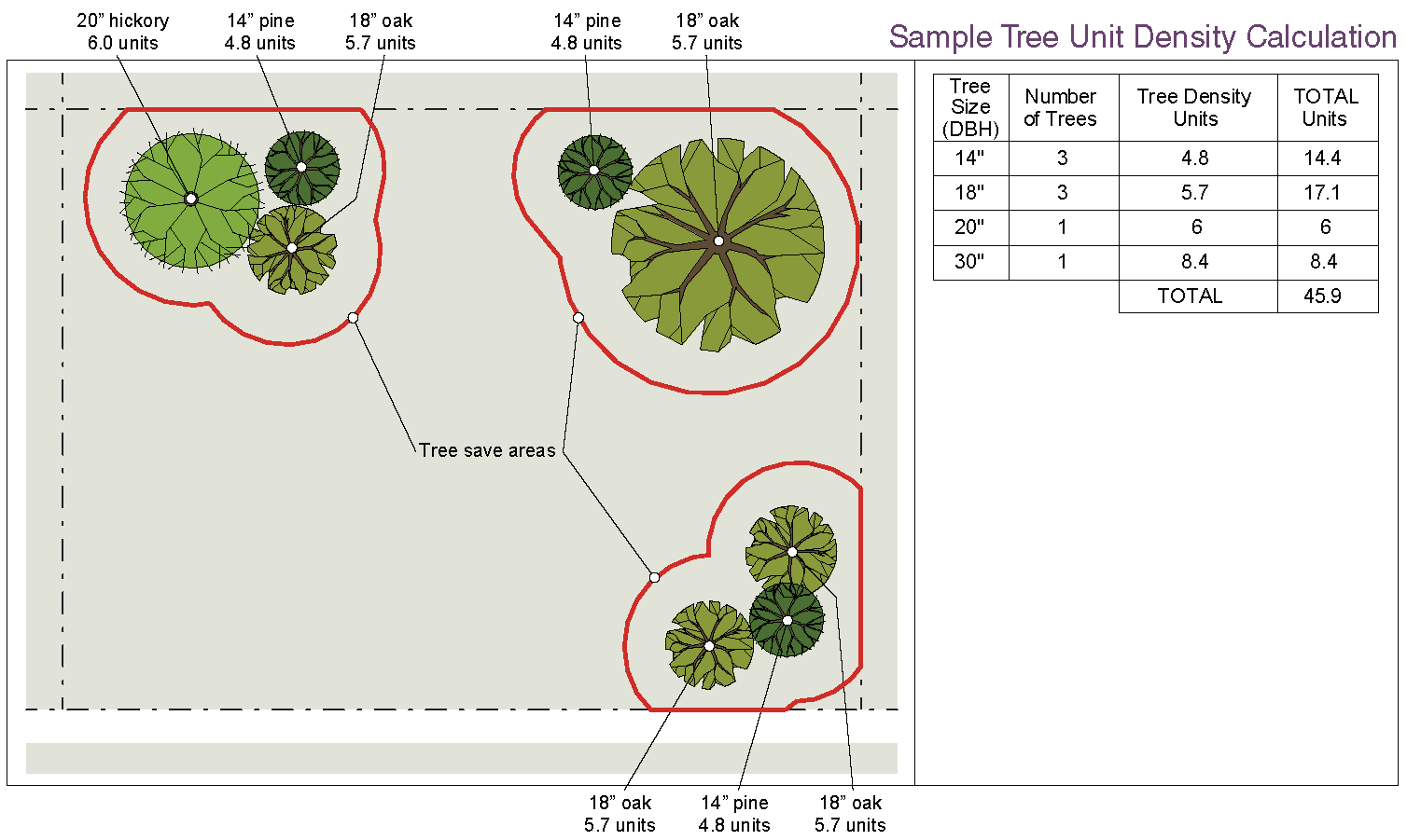
Sample Tree Unit Density Calculation
FORMULA:
Total Tree Density Units (Required Tree Density Units Per Acre from Sec. 12.1.5.B. × Site Acres)
− Existing Tree Density Units Protected in Tree Save Areas
= Replacement Tree Density Units (Required Density of Newly Planted Trees)
EXAMPLE:
Step 1: Calculate total requirement for your site.
2.2 acre site with a requirement of 30 tree density units per acre (see table in Sec. 12.1.5.B.)
Total tree density units required is 66 (2.2 × 30)
Step 2: Conduct a tree survey on your site. Calculate existing tree density units protected in a tree save area.
A total of 8 existing trees will be protected in tree save areas on the site.
3 - 14" pines
3 - 18" oaks
1 - 20" hickory
1 - 30" oak
Converted to tree density units using table.
Step 3. Calculate any tree density unit deficit by subtracting the existing protected tree density units from the total required.
66 tree density units required − 45.9 protected tree density units = 20.1 additional tree density units needed.
Newly planted trees (Sec. 12.1.6) or a fee in lieu (Sec. 12.1.7) are required to make up any deficit.
12.1.6. - Tree Replacement
A.
Tree Replacement Plan. Trees must be relocated or replaced on site unless a fee in lieu of replanting is contributed. As many trees as can reasonably be expected to survive must be planted on the site. This provision may require planting less trees of a larger caliper than the minimum required caliper.
1.
Separate Drawing. A separate tree replacement plan indicating the location of all proposed trees for revegetation is required. This plan must be submitted as a separate drawing, but with the City Arborist's approval, may be included as a part of the tree protection plan.
2.
Planting Schedules and Species Names. The tree replacement plan must include planting schedules with proposed tree species names (botanical and common), quantity, size, spacing and any special planting notes.
3.
Overstory/Understory Ratio. Replanting must be at a ratio of not less than 1 overstory tree for every 3 understory trees. Tree density credit may be met by planting all overstory trees, but not by planting only understory trees.
4.
Diversity. No more than 40% of any one genus may be included in any replanting plan. Exceptions to this requirement may be authorized by the City Arborist.
5.
Approved Trees. Unless otherwise approved by the City Arborist, trees selected for replanting must be on the tree species selection list maintained by the City. Invasive trees are not allowed under any circumstances. Trees selected must be free from injury, pests, disease, nutritional disorders or root defects, and must be in good vigor in order to assure a reasonable expectation of survival. It is desirable that replanted trees be ecologically compatible with the site and neighboring sites. Accordingly, replanted trees must be of the same or similar species as those removed, when practical.
6.
Flowering Ornamental Trees. The use of flowering ornamental trees or plants classified as large shrubs may be included in the tree replacement plan, but must not be used for the purpose of meeting minimum tree density unit requirements for the site unless approved by the City Arborist.
7.
Transplanting of Trees. Standards for transplanting must be in keeping with those established in the International Society of Arboriculture Tree and Shrub Planting Manual.
8.
Planting and Staking Details. Planting and staking details must be provided on the tree replacement plan as determined by the City Arborist using International Society of Arboriculture (ISA) standards.
9.
Practices. Roswell encourages environmentally sustainable design practices such as drought-tolerant landscaping, keeping turf away from native trees, and planting trees strategically for energy conservation.
10.
Debris. All debris from trees cut or substantially damaged must be removed from the site or chipped in a timely fashion, including the removal or chipping of any portion of the tree stump above the original natural grade or elevation of land.
B.
Calculation of Replacement Tree Density. Newly planted trees are eligible for tree density credit based on the following table. Replacement trees may include street trees planted in public rights-of-way adjacent to the site.
1.
A 7-gallon container-grown pine tree is given replacement credit of 0.3 units.
2.
For tree relocation, replacement units will be granted to trees relocated on site. Tree relocation is subject to approval by the City Arborist.
C.
Replacement Tree Size and Height.
1.
All replanted overstory trees must be a minimum of 8 feet tall and have a trunk of not less than 3 caliper inches.
2.
All replanted understory trees must be a minimum of 6 feet tall and have a trunk of not less than 2 caliper inches.
D.
Minimum Root Zone.
1.
In order to provide sufficient growing area for planted trees, the following minimum criteria must be observed unless otherwise approved by the City Arborist:
a.
Overstory Tree: 200 square feet of pervious root zone.
b.
Understory Tree: 75 square feet of pervious root zone.
2.
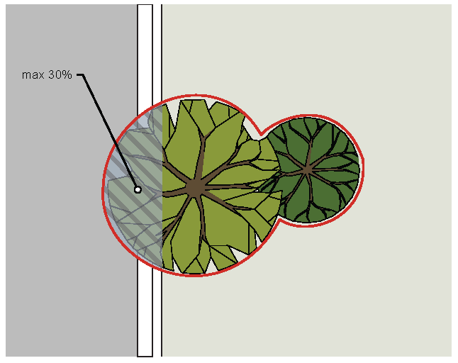
Impervious surface area may encroach into no more than 30% of the pervious root zone of a tree to be protected or planted, with techniques approved by the City Arborist.
E.
Permit. No land disturbance permit may be issued until the City Arborist has approved the tree replacement plan and a performance bond.
F.
Maintenance. All replacement trees must be maintained properly to ensure their survival.
12.1.7. - Fee in Lieu of Replacement Trees
A.
Intent. The intent of this section is to ensure that a minimum density of trees is maintained on all developed sites. Occasionally, this intent cannot be met on-site, because a site will not bear the required density of trees once development is completed. To provide relief in such cases, at the discretion of the City Arborist, the applicant may contribute funds to the Roswell Tree Bank.
B.
City Arborist Authority. The City Arborist must review and approve or deny all requests for a fee in lieu of replacement trees. In no instance may more than 90% of the required tree density units be met through payment of a fee in lieu.
C.
Permit. No Land Disturbance Permit may be issued until the City Arborist has approved any fee in lieu request and funds are received for deposit in the Roswell Tree Bank.
D.
Roswell Tree Bank. The City will accept donations to the Roswell Tree Bank. These donations will be used for the sole purpose of planting and maintaining trees and other applicable landscaping for public benefit on public property or private property within a public easement within the City of Roswell. Proposed landscaping may include shrubs and small trees. Maintenance is limited to tree, shrubs, and small trees, and excludes maintenance of grassed lawns. Other associated project tasks that may be permitted to use the Roswell Tree Bank funds include tree boxes or porous pavement that may enhance tree growth; these applications are subject to approval by Mayor and City Council.
E.
Required Contribution. The required contribution amount is $220 per tree density unit, based on cost of materials, labor and guarantee for trees planted in the Roswell area.
F.
Fund Administration. The Roswell Tree Bank will be administered by the City Finance Department, with disbursements of tree bank funds initiated by the City Arborist and approved by the Mayor and City Council. An annual report must be prepared by the Roswell Finance Department and submitted to the City Administrator showing amounts collected, amounts spent, and the type and location of plantings or maintenance completed. An annual audit prepared by an independent auditor will suffice to meet this requirement.
(Ord. No. 2017-04-03, § 1, 4-10-2017)
12.1.8. - Tree Protection During Construction
A.
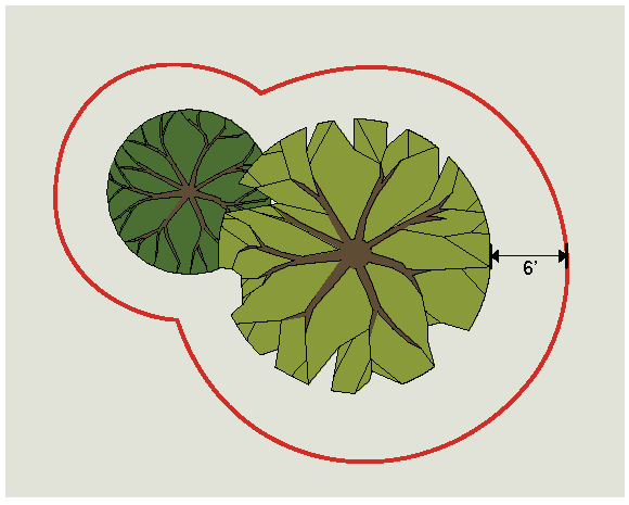
Materials Prohibited in Tree Save Areas. No structure, improvement, or any activity including solvents, material, construction machinery, portable toilets, construction trailers, or temporary soil deposits may encroach or be placed within a drip line or within 6 feet of the area immediately outside the drip line of any specimen tree or any tree within a tree save area unless authorized by the City Arborist in writing.
B.
Tree Protection Devices. Before development, land clearing, filling, or any land alteration, the developer is required to erect suitable protective barriers required by the City Arborist pursuant to an approved tree protection plan, including tree fences, tree protection signs, and erosion barriers. City inspection of tree protection barriers is required prior to the commencement of any land disturbance or development. Tree protection measures must remain in functioning condition until completion of site landscaping, completion of the project, or until the certificate of occupancy is issued. Authorization to remove the protective devices must be evidenced by approval in writing by the City Arborist or issuance of a final certificate of occupancy.
C.
Active Tree Protection Devices. Materials for active tree protection must consist of chain link, orange laminated plastic, wooden post and rail fencing or other equivalent restraining material. In addition to fencing, where active tree protection is required, each tree to be saved must be marked at the base of the trunk with blue colored water-based paint.
D.
Passive Tree Protection. Passive tree protection fencing is to be used only for areas remote from construction activity. Materials for passive tree protection must consist of heavy mil. plastic flagging, a minimum of 4 inches wide with dark letters reading "Tree Protection Area - Do Not Enter" or equivalent signage on a continuous, durable restraint.
E.
Additional Measures. The developer must take measures to ensure the health of protected trees during construction, including, but not limited to:
1.
Water, fertilize and treat the trees for pests or disease as needed, in accordance with standards of the International Society of Arboriculture.
2.
Where grading covers the trees with dust, hose them off.
3.
Do not prune branches so that equipment or structures "fit" within the tree's protected zone.
4.
Do not strip the topsoil or remove the natural leaf mulch or material from beneath a protected tree.
5.
Trees should be felled away from, rather than into, tree save areas.
6.
Provide adequate mulching and water for trees that will be retained.
F.
Tree Damage. Any tree designated on a tree protection plan to be saved damaged during construction or as a result of construction, as determined by the City Arborist, must be treated according to accepted standards of the National Arborists Association, or replaced with trees equal to the tree density unit value of the tree removed or damaged. However, any specimen tree damaged must be replaced with trees equal to 2 times the tree density unit value of the tree removed or damaged. Where a damaged specimen tree must be removed, the area occupied by its drip line must remain in a pervious state. A replacement plan must be approved by the City Arborist.
12.1.9. - Tree Maintenance
A.
To prevent long-term harm to the health of trees or their structure, all pruning of trees within the City of Roswell must be done in accordance with ANSI A300 Tree, Shrub, and Other Woody Plant Management Standard Practices (Pruning).
B.
On a single lot that contains, or is zoned and platted for purposes of constructing, a detached or attached house, this paragraph applies only to specimen trees.
C.
"Topping," defined as removal of more than one-third of the leaves and branches of a tree, as measured from the lowest branch on the trunk of the tree to the top of the tree, is prohibited.
D.
The applicant must post a maintenance bond in the form of cash or an irrevocable letter of credit covering a period of two years. If the applicant does not continue to comply with this Section and the conditions of the permit after issuance, the City may call the bond or any part of the bond to be forfeited and use the proceeds to hire a contractor to bring the site into compliance.
12.2.1 - Findings and Purposes
A.
Findings. Whereas, the City of Roswell finds that buffers adjacent to streams provide numerous benefits including:
1.
Protecting, restoring and maintaining the chemical, physical and biological integrity of streams and their water resources
2.
Removing pollutants delivered in urban stormwater
3.
Reducing erosion and controlling sedimentation
4.
Protecting and stabilizing stream banks
5.
Providing for infiltration of stormwater runoff
6.
Maintaining base flow of streams
7.
Contributing organic matter that is a source of food and energy for the aquatic ecosystem
8.
Providing tree canopy to shade streams and promote desirable aquatic habitat
9.
Providing riparian wildlife habitat
10.
Furnishing scenic value and recreational opportunity
11.
Providing opportunities for the protection and restoration of greenspace
B.
Purposes. It is the purpose of this ordinance is to protect the public health, safety, environment and general welfare; to minimize public and private losses due to erosion, siltation and water pollution; and to maintain stream water quality by provisions designed to:
1.
Create buffer zones along the streams of the City of Roswell for the protection of water resources; and,
2.
Minimize land development within such buffers by establishing buffer zone requirements and by requiring authorization for any such activities.
(Ord. No. 2020-12-20, § 1, 12-14-2020)
12.2.2. - Applicability
This ordinance shall apply to all land development activity on property containing a stream protection area as defined in section 12.2.2. of this ordinance. These requirements are in addition to, and do not replace or supersede, any other applicable buffer requirements established under state law and approval or exemption from these requirements do not constitute approval or exemption from buffer requirements established under state law or from other applicable local, state or federal regulations. The Water Resources Map is hereby adopted and made a part of this UDC.
A.
Grandfathered provisions. This ordinance shall not apply to the following activities:
1.
Work consisting of the repair or maintenance of any lawful use of land that is zoned and approved for such use on or before the effective date of this ordinance.
2.
Existing development and on-going land disturbance activities including but not limited to existing agriculture, silviculture, landscaping, gardening and lawn maintenance, except that new development or land disturbance activities on such properties will be subject to all applicable buffer requirements.
3.
Any land development activity that is under construction, fully approved for development, scheduled for permit approval or has been submitted for approval as of the effective date of this ordinance.
4.
Land development activity that has not been submitted for approval, but that is part of a larger master development plan, such as for an office park or other phased development that has been previously approved within two years of the effective date of this ordinance.
B.
Exemptions. The following specific activities are exempt from this ordinance. Exemption of these activities does not constitute an exemption for any other activity proposed on a property.
1.
Activities for the purpose of building one of the following:
a.
A stream crossing by a driveway, transportation route or utility line;
b.
Public water supply intake or public wastewater outfall structures;
c.
Intrusions necessary to provide access to a property;
d.
Public access facilities that must be on the water including boat ramps, docks, foot trails leading directly to the river, fishing platforms and overlooks;
e.
Unpaved foot trails and paths;
f.
Activities to restore and enhance stream bank stability, vegetation, water quality and/or aquatic habitat, so long as native vegetation and bioengineering techniques are used.
2.
Public sewer line easements paralleling the creek, except that all easements (permanent and construction) and land disturbance should be at least 25 feet from the top of the bank. This includes such impervious cover as is necessary for the operation and maintenance of the utility, including but not limited to manholes, vents and valve structures. This exemption shall not be construed as allowing the construction of roads, bike paths or other transportation routes in such easements, regardless of paving material, except for access for the uses specifically cited in item 12.2.3.B.1. above.
3.
Land development activities within a right-of-way existing at the time this ordinance takes effect or approved under the terms of this ordinance.
4.
Within an easement of any utility existing at the time this ordinance takes effect or approved under the terms of this ordinance, land disturbance activities and such impervious cover as is necessary for the operation and maintenance of the utility, including but not limited to manholes, vents and valve structures.
5.
Emergency work necessary to preserve life or property. However, when emergency work is performed under this section, the person performing it shall report such work to the City of Roswell on the next business day after commencement of the work. Within 10 days thereafter, the person shall apply for a permit and perform such work within such time period as may be determined by the City of Roswell to be reasonably necessary to correct any impairment such emergency work may have caused to the water conveyance capacity, stability or water quality of the protection area.
6.
Forestry and silviculture activities on land that is zoned for forestry, silvicultural or agricultural uses and are not incidental to other land development activity. If such activity results in land disturbance in the buffer that would otherwise be prohibited. then no other land disturbing activity other than normal forest management practices will be allowed on the entire property for three years after the end of the activities that intruded on the buffer.
After the effective date of this ordinance, it shall apply to new subdividing and platting activities.
Any land development activity within a buffer established hereunder or any impervious cover within a setback established hereunder is prohibited unless a variance is granted pursuant to section 12.2.3.B. below.
(Ord. No. 2020-12-20, § 1, 12-14-2020)
12.2.3. - Land Development Requirements
A.
Buffer and setback requirements. All land development activity subject to this ordinance shall meet the following requirements:
1.
Requirements for all state waters.
a.
All intermittent and perennial streams an undisturbed natural vegetative buffer shall be maintained for 25 feet, measured horizontally, on both banks (as applicable) of the stream from the top of the stream bank.
2.
Requirements for Intermittent Streams.
a.
An undisturbed natural vegetative buffer shall be maintained for 50 feet, measured horizontally, on both banks (as applicable) of the stream as measured from the top of the stream bank.
b.
An additional setback shall be maintained for 25 feet, measured horizontally, beyond the undisturbed natural vegetative buffer, in which all impervious cover shall be prohibited. Grading, filling and earthmoving shall be minimized within the setback.
c.
No septic tanks or septic tank drain fields shall be permitted within the buffer or the setback.
3.
Requirements for Perennial Streams.
a.
An undisturbed natural vegetative buffer shall be maintained for 100 feet, measured horizontally, on both banks (as applicable) of the stream as measured from the top of the stream bank.
b.
An additional setback shall be maintained for 50 feet, measured horizontally, beyond the undisturbed natural vegetative buffer, in which all impervious cover shall be prohibited. Grading, filling and earthmoving shall be minimized within the setback.
c.
No septic tanks or septic tank drain fields shall be permitted within the buffer or the setback.
B.
Variance Procedures. Variances from the above buffer and setback requirements may be granted in accordance with the following provisions:
1.
Where a parcel was platted prior to the effective date of this ordinance, and its shape, topography or other existing physical condition prevents land development consistent with this ordinance, and the Engineering Director finds and determines that the requirements of this ordinance prohibit the otherwise lawful use of the property by the owner, the Engineering Director may grant a variance from the buffer and setback requirements for residential installation of pools, decks, patios and retaining walls less than six (6) feet in height provided such variance require mitigation measures to offset the effects of any proposed land development on the parcel. If sufficient mitigation measures are not proposed and accepted by the Engineering Director, or if sufficient mitigation measures cannot be accommodated on the site based on the site plan, the application must be submitted to the Board of Zoning Appeals.
2.
The Board of Zoning Appeals of the City of Roswell shall grant no variance from any provision of this ordinance without first conducting a public hearing on the application for variance and authorizing the granting of the variance by an affirmative vote of the Board of Zoning Appeals. The City of Roswell shall give public notice of each such public hearing in a newspaper of general circulation within the City of Roswell. The City of Roswell shall require that the applicant post a sign giving notice of the proposed variance and the public hearing. The sign shall be of a size and posted in such a location on the property as to be clearly visible from the primary adjacent road right-of-way. Variances will be considered only in the following cases:
a.
When a property's shape, topography or other physical conditions existing at the time of the adoption of this ordinance prevents land development unless a buffer variance is granted.
b.
Unusual circumstances when strict adherence to the minimal buffer requirements in the ordinance would create an extreme hardship.
Variances will not be considered when, following adoption of this ordinance, actions of any property owner of a given property have created conditions of a hardship on that property.
3.
At a minimum, a variance request shall include the following information:
a.
A site map that includes locations of all streams, wetlands, floodplain boundaries and other natural features, as determined by field survey;
b.
A description of the shape, size, topography, slope, soils, vegetation and other physical characteristics of the property;
c.
A detailed site plan that shows the locations of all existing and proposed structures and other impervious cover, the limits of all existing and proposed land disturbance, both inside and outside the buffer and setback. The exact area of the buffer to be affected shall be accurately and clearly indicated;
d.
Documentation of unusual hardship should the buffer be maintained;
e.
At least one alternative plan, which does not include a buffer or setback intrusion, or an explanation of why such a site plan is not possible;
f.
A calculation of the total area and length of the proposed intrusion;
g.
A stormwater management site plan, if applicable; and,
h.
Proposed mitigation, if any, for the intrusion. If no mitigation is proposed, the request must include an explanation of why none is being proposed.
4.
The following factors will be considered in determining whether to issue a variance:
a.
The shape, size, topography, slope, soils, vegetation and other physical characteristics of the property;
b.
The locations of all streams on the property, including along property boundaries;
c.
The location and extent of the proposed buffer or setback intrusion; and,
d.
Whether alternative designs are possible which require less intrusion or no intrusion:
e.
The long-term and construction water-quality impacts of the proposed variance;
f.
Whether issuance of the variance is at least as protective of natural resources and the environment.
(Ord. No. 2020-12-20, § 1, 12-14-2020; Ord. No. 2021-08-13, § 1, 8-9-2021)
12.2.4. - Compatibility with other Buffer Regulations and Requirements
This ordinance is not intended to interfere with, abrogate or annul any other ordinance, rule or regulation, statute or other provision of law. The requirements of this ordinance should be considered minimum requirements, and where any provision of this ordinance imposes restrictions different from those imposed by any other ordinance, rule, regulation or other provision of law, whichever provisions are more restrictive or impose higher protective standards for human health or the environment shall be considered to take precedence.
(Ord. No. 2020-12-20, § 1, 12-14-2020)
12.2.5. - Land Disturbance Permit Application
A separate application for a Land Disturbance Permit must be made for each land-disturbing activity or any other act which alters the hydraulic or vegetative characteristics of a stream protection area. The application must include a map of the site and such information concerning the proposed action as the Engineering Director deems necessary to describe the nature and extent of the proposed action and to determine the effect of the proposed action on the stream protection area.
(Ord. No. 2020-12-20, § 1, 12-14-2020)
12.2.6. - Land Disturbance Permit Issuance
No application for a Land Disturbance Permit application may be approved and no permit may be issued for any land-disturbing activity inconsistent with the requirements herein.
(Ord. No. 2020-12-20, § 1, 12-14-2020)
12.2.7. - Additional Information Requirements for Development on Buffer Zone Properties
A.
Any permit applications for property requiring buffers and setbacks hereunder must include the following:
1.
A site plan showing:
a.
The location of all streams on the property;
b.
Limits of required stream buffers and setbacks on the property;
c.
Buffer zone topography with contour lines at no greater than five (5)-foot contour intervals;
d.
Delineation of forested and open areas in the buffer zone; and,
e.
Detailed plans of all proposed land development in the buffer and of all proposed impervious cover within the setback;
2.
A description of all proposed land development within the buffer and setback; and,
3.
Any other documentation that the Engineering Director may reasonably deem necessary for review of the application and to insure that the buffer zone ordinance is addressed in the approval process.
B.
All buffer and setback areas must be recorded on the final plat of the property following plan approval.
(Ord. No. 2020-12-20, § 1, 12-14-2020)
12.2.8. - Responsibility
Neither the issuance of a development permit nor compliance with the conditions thereof, nor with the provisions of this ordinance shall relieve any person from any responsibility otherwise imposed by law for damage to persons or property; nor shall the issuance of any permit hereunder serve to impose any liability upon the City of Roswell, its officers or employees, for injury or damage to persons or property.
(Ord. No. 2020-12-20, § 1, 12-14-2020)
12.2.9. - Inspection
The Engineering Director may cause inspections of the work in the buffer or setback to be made periodically during the course thereof and shall make a final inspection following completion of the work. The permittee shall assist the Engineering Director in making such inspections. The City of Roswell shall have the authority to conduct such investigations as it may reasonably deem necessary to carry out its duties as prescribed in this ordinance, and for this purpose to enter at reasonable time upon any property, public or private, for the purpose of investigating and inspecting the sites of any land development activities within the protection area.
No person shall refuse entry or access to any authorized representative or agent who requests entry for purposes of inspection, and who presents appropriate credentials, nor shall any person obstruct, hamper or interfere with any such representative while in the process of carrying out official duties.
(Ord. No. 2020-12-20, § 1, 12-14-2020)
12.2.10. - Violations, Enforcement and Penalties
Any action or inaction which violates the provisions of this ordinance or the requirements of an approved site plan or permit issued under this ordinance may be subject to the enforcement actions outlined in this section. Any such action or inaction which is continuous with respect to time is deemed to be a public nuisance and may be abated by injunctive or other equitable relief. The imposition of any of the penalties described below shall not prevent such equitable relief.
A.
Notice of Violation. If the Engineering Director determines that an applicant or other responsible person has failed to comply with the terms and conditions of a permit, an approved site plan or the provisions of this ordinance, it shall issue a written notice of violation to such applicant or other responsible person. Where a person is engaged in activity covered by this ordinance without having first secured the appropriate permit therefor, the notice of violation shall be served on the owner or the responsible person in charge of the activity being conducted on the site. The notice of violation shall contain:
1.
The name and address of the owner or the applicant or the responsible person;
2.
The address or other description of the site upon which the violation is occurring;
3.
A statement specifying the nature of the violation;
4.
A description of the remedial measures necessary to bring the action or inaction into compliance with the permit, the approved site plan or this ordinance and the date for the completion of such remedial action;
5.
A statement of the penalty or penalties that may be assessed against the person to whom the notice of violation is directed; and,
6.
A statement that the determination of violation may be appealed to the (review and permitting authority) by filing a written notice of appeal within thirty (30) days after the notice of violation (except that in the event the violation constitutes an immediate danger to public health or public safety, 24 hour notice shall be sufficient).
B.
Penalties. In the event the remedial measures described in the notice of violation have not been completed by the date set forth for such completion in the notice of violation, any one or more of the following actions or penalties may be taken or assessed against the person to whom the notice of violation was directed. Before taking any of the following actions or imposing any of the following penalties, the Engineering Director shall first notify the applicant or other responsible person in writing of its intended action, and shall provide a reasonable opportunity, of not less than ten days (except that in the event the violation constitutes an immediate danger to public health or public safety, 24 hour notice shall be sufficient) to cure such violation. In the event the applicant or other responsible person fails to cure such violation after such notice and cure period, the Engineering Director may take any one or more of the following actions or impose any one or more of the following penalties.
1.
Stop Work Order - the Engineering Director may issue a stop work order which shall be served on the applicant or other responsible person. The stop work order shall remain in effect until the applicant or other responsible person has taken the remedial measures set forth in the notice of violation or has otherwise cured the violation or violations described therein, provided the stop work order may be withdrawn or modified to enable the applicant or other responsible person to take necessary remedial measures to cure such violation or violations.
2.
Withhold Certificate of Occupancy - the Engineering Director may refuse to issue a certificate of occupancy for the building or other improvements constructed or being constructed on the site until the applicant or other responsible person has taken the remedial measures set forth in the notice of violation or has otherwise cured the violations described therein.
3.
Suspension, Revocation or Modification of Permit - the Engineering Director may suspend, revoke or modify the permit authorizing the land development project. A suspended, revoked or modified permit may be reinstated after the applicant or other responsible person has taken the remedial measures set forth in the notice of violation or has otherwise cured the violations described therein, provided such permit may be reinstated (upon such conditions as the Engineering Director may deem necessary) to enable the applicant or other responsible person to take the necessary remedial measures to cure such violations.
4.
Civil Penalties - in the event the applicant or other responsible person fails to take the remedial measures set forth in the notice of violation or otherwise fails to cure the violations described therein within ten days (or such greater period as the Engineering Director shall deem appropriate) (except that in the event the violation constitutes an immediate danger to public health or public safety, 24 hour notice shall be sufficient) after the Engineering Director has taken one or more of the actions described above, the Engineering Director may impose a penalty not to exceed $1,000 (depending on the severity of the violation) for each day the violation remains un-remedied after receipt of the notice of violation.
5.
Criminal Penalties - for intentional and flagrant violations of this ordinance, the Engineering Director may issue a citation to the applicant or other responsible person, requiring such person to appear in the City of Roswell court to answer charges for such violation. Upon conviction, such person shall be punished by a fine not to exceed $1,000 or imprisonment for 60 days or both. Each act of violation and each day upon which any violation shall occur shall constitute a separate offense.
(Ord. No. 2020-12-20, § 1, 12-14-2020)
12.2.11. - Administrative Appeal and Judicial Review
A.
Administrative appeal. Any person aggrieved by a decision or order of the Engineering Director, may appeal in writing within 30 calendar days after the issuance of such decision or order to the Community Development Department of the City of Roswell and shall be entitled to a hearing before the Board of Zoning Appeals of the City of Roswell within 35 calendar days of receipt of the written appeal.
B.
Judicial review. Any person aggrieved by a decision or order of the Engineering Director, after exhausting all administrative remedies, shall have the right to appeal de novo to the Fulton County Superior Court.
(Ord. No. 2020-12-20, § 1, 12-14-2020)
12.2.12. - Severability
If any article, section, subsection, paragraph, clause, phrase or provision of this ordinance shall be adjudged invalid or held unconstitutional, such decision shall not affect or invalidate the remaining portions of this ordinance.
(Ord. No. 2020-12-20, § 1, 12-14-2020)
12.2.13. - Definitions for Stream Buffer Protection only
Buffer with respect to a stream. A natural or enhanced vegetated area established by section 12.2.3.A., lying adjacent to the stream.
Floodplain. Any land area susceptible to flooding, which would have at least a one percent probability of flooding occurrence in any calendar year based on the basin being fully developed as shown on the current land use plan; i.e., Area of Special Flood Hazard.
Impervious surface or impervious cover. A man-made structure or surface which prevents the infiltration of stormwater into the ground below the structure or surface. Examples are buildings, roads, driveways, parking lots, decks, swimming pools or patios.
Land development. Any land change, including but not limited to clearing, grubbing, stripping, removal of vegetation, dredging, grading, excavating, transporting and filling of land, construction, paving and any other installation of impervious cover.
Land development activity or activities. Those actions or activities which comprise, facilitate or result in land development.
Land disturbance. Any land or vegetation change, including, but not limited to, clearing, grubbing, stripping, removal of vegetation, dredging, grading, excavating, transporting and filling of land, that do not involve construction, paving or any other installation of impervious cover.
Land disturbance activity. Those actions or activities which comprise, facilitate or result in land disturbance.
Parcel. Any plot, lot or acreage shown as a unit on the latest county tax assessment records.
Permit. The permit issued by the City of Roswell required for undertaking any land development activity
Person. Except to the extent exempted from this UDC, any individual, partnership, firm, association, joint venture, public or private corporation, trust, estate, commission, board, public or private institution, utility, cooperative, city, county or other political subdivision of the state, any interstate body or any other legal entity.
Protection area, or stream protection area. With respect to a stream, the combined areas of all required buffers and setbacks applicable to such stream.
Riparian. Belonging or related to the bank of a river, stream, lake, pond or impoundment.
Setback with respect to a stream. The area established by section 12.2.3.A extending beyond any buffer applicable to the stream.
Stream. Any stream, beginning at:
1.
The location of a spring, seep, or groundwater outflow that sustains streamflow; or
2.
A point in the stream channel with a drainage area of 25 acres or more; or
3.
Where evidence indicates the presence of a stream in a drainage area of other than 25 acres, the City of Roswell may require field studies to verify the existence of a stream.
4.
Refer to the City of Roswell Water Resources Map for designated intermittent and perennial stream locations.
Stream bank. The sloping land that contains the stream channel and the normal flows of the stream.
Stream channel. The portion of a watercourse that contains the base flow of the stream.
Watershed. The land area that drains into a particular stream.
(Ord. No. 2020-12-20, § 1, 12-14-2020)
12.3.1. - Purpose and Intent
The groundwater recharge requirements are intended to implement rules of the Georgia Department of Natural Resources Environmental Protection Division known as the "Rules for Environmental Planning Criteria" as they specifically relate to groundwater recharge areas (Rule 391-3-16-.02).
12.3.2. - Applicability
A.
The groundwater recharge requirements apply to all lands that are mapped as significant recharge areas.
B.
No Land Disturbance Permit or Building Permit may be issued for any building or structure to be served by a septic tank unless the land use or building conforms to the groundwater recharge requirements of the UDC.
C.
Prior to a Land Disturbance Permit or Building Permit being issued, a site plan or subdivision plat in sufficient detail to review the proposed development for compliance with the groundwater recharge requirements must be submitted.
12.3.3. - County Health Department Approval
No Land Disturbance Permit or Building Permit may be issued for a building or structure to be served by a septic tank unless the Fulton County Health Department first approves the proposed septic tank installation as meeting the requirements of the Georgia Department of Human Resources Manual for On-Site Sewage Management Systems (DHR Manual) and this Section.
12.3.4. - Minimum Lot Size
A.
Within an area governed by the groundwater recharge requirements, new homes or land uses served by a septic tank and drain field system must be on lots having minimum lot sizes as follows, based on application of Table MT-1 of the DHR Manual. The minimums set forth in DHR Table MT-1 may be increased further based on consideration of other factors set forth in Sections A—F of the DHR Manual, as determined by the Fulton County Health Department.
1.
150% of the minimum lot size calculated based on application of DHR Table MT-1 if they are within a high pollution susceptibility area;
2.
125% of the minimum lot size calculated based on application of DHR Table MT-1 if they are within an average or medium pollution susceptibility area;
3.
110% of the minimum lot size calculated based on application of DHR Table MT-1 if they are within a low pollution susceptibility area.
B.
Any lot of record approved prior to the adoption of these requirements is exempt from the minimum lot size requirements.
C.
Within an area governed by the groundwater recharge requirements, no subdivision plat may be recorded until the plat has been approved by the Zoning Director as being in compliance with the minimum lot sizes established by these requirements.
12.3.5. - Uses Prohibited
Within an area governed by the groundwater recharge requirements, the following uses are prohibited:
A.
Above-ground chemical or petroleum storage tanks;
B.
Agricultural waste impoundment sites;
C.
Hazardous materials handling facilities;
D.
Manufactured homes; and
E.
Manufactured home parks.
12.3.6. - Variances and Appeals
A.
Applicants with a hardship imposed by the standards for groundwater recharge may seek a variance to the standards (see Sec. 13.11.).
B.
Applicants dissatisfied with a staff decision regarding groundwater recharge may appeal the decision to the Board of Zoning Appeals (see Sec. 13.12.).
12.4.1. - Purpose and Intent
The purpose of these requirements are to promote wetlands protection by withholding land use and building permits in areas designated as wetlands until a jurisdictional wetland determination is completed, and establishing permitted and prohibited land uses within wetlands.
12.4.2. - Applicability
These requirements apply to all lands that are shown on the National Wetlands Database as wetlands.
12.4.3. - Permit Required
A.
No Land Disturbance Permit or Building Permit may be issued by the Engineering Director for a land use, building or structure, or any regulated activity commence, unless the land use, building, structure, or regulated activity conforms to the wetland requirements of this UDC.
B.
A regulated activity is considered any activity that will or may reasonably be expected to result in the discharge of dredged or fill material into waters of the U.S., excepting those activities exempted in Section 404 of the Federal Clean Water Act.
C.
Prior to a Land Disturbance Permit or Building Permit being issued, the Engineering Director will require a site plan or subdivision plat in sufficient detail to review the proposed development for compliance with the provisions of these requirements.
12.4.4. - Jurisdictional Wetland Determination
If an area proposed for development is located within 50 feet of a wetland as shown on the National Wetlands Database, as determined by the Engineering Director, no Land Disturbance Permit or Building Permit for the area designated wetland or any area within 50 feet of the designated wetland may be issued until a jurisdictional wetland determination has been completed and either of the following occur:
A.
The U.S. Army Corps of Engineers determines that there are jurisdictional wetlands present on the proposed development site, a Section 404 permit is required, and either a Section 404 Permit or a letter of permission is issued by the Corps for the proposed development; or
B.
The U.S. Army Corps of Engineers determines that jurisdictional wetlands are not present on the proposed development site, and no Section 404 permit or letter of permission is required.
12.4.5. - Prohibited and Permitted Uses
A.
Receiving areas for toxic or hazardous waste or other contaminants, and hazardous or sanitary waste landfills, are prohibited.
B.
The following uses are permitted, subject to use restrictions for the zoning district in which the wetland is located, within an area shown as a wetland on the generalized wetlands map, to the extent that they are not prohibited by any other ordinance or law, including laws of trespass, and provided they do not require structures, grading, fill, draining, or dredging except as provided here:
1.
Conservation or preservation of soil, water, vegetation, fish and other wildlife, provided it does not affect waters of Georgia or of the United States in such a way that would require an individual 404 Permit;
2.
Outdoor passive recreational activities, including fishing, bird watching, hiking, boating, horseback riding and canoeing;
3.
Forestry practices applied in accordance with best management practices approved by the Georgia Forestry Commission and as specified in Section 404 of the Clean Water Act;
4.
The cultivation of agricultural crops, subject to best management practices approved by the Georgia Department of Agriculture;
5.
The pasturing of livestock, provided that riparian wetlands are protected, that soil profiles are not disturbed and that approved agricultural best management practices are followed; and
6.
Education, scientific research and nature trails.
12.4.6. - Variances and Appeals
No local variance or appeal processes are available for issues related to federal wetlands.
12.5.1. - General Provisions
A.
Purpose and Intent. The purpose of this article is to protect, maintain and enhance the public health, safety, environment and general welfare by establishing minimum requirements and procedures to control the adverse effects of increased post-construction stormwater runoff and nonpoint source pollution associated with new development and redevelopment. Proper management of post- construction stormwater runoff will minimize damage to public and private property and infrastructure, safeguard the public health, safety, environment and general welfare of the public, and protect water and aquatic resources. Additionally, the City of Roswell is required to comply with several State and Federal laws, regulations and permits and the requirements of the Metropolitan North Georgia Water Planning District's regional water plan related to managing the water quantity, velocity, and quality of post- construction stormwater runoff.
These stormwater management requirements seek to meet that purpose through the following objectives:
1.
Establish decision-making processes surrounding land development activities that protect the integrity of the watershed and preserve the health of water resources;
2.
Require that new development and redevelopment maintain the pre-development hydrologic response in their post-development state as nearly as practicable in order to reduce flooding, streambank erosion, nonpoint source pollution and maintain the integrity of stream channels and aquatic habitats;
3.
Establish design and application criteria for the construction and use of structural stormwater control facilities that can be used to meet the minimum post-development stormwater management standards;
4.
Encourage the use of nonstructural stormwater management and stormwater better site design practices, such as the preservation of green space and other conservation areas, to the maximum extent practicable;
5.
Establish provisions for the long-term responsibility for and maintenance of structural stormwater control facilities and nonstructural stormwater management practices to ensure that they continue to function as designed, are maintained, and pose no threat to public safety; and
6.
Establish administrative procedures for the submission, review, approval and disapproval of stormwater management plans, and for the inspection of approved active projects, and long-term follow up.
B.
Stormwater Design Manual. Adoption and Implementation of the Georgia Stormwater Management Manual; Conflicts and Inconsistencies.
1.
In implementing this Article, the City of Roswell shall use and require compliance with all relevant design standards, calculations, formulas, methods, and other guidance from the Georgia Stormwater Management Manual (GSMM) as well as all related appendices.
2.
This Article is not intended to modify or repeal any other Article, ordinance, rule, regulation or other provision of law, including but not limited to any applicable stream buffers under state and local laws, and the Georgia Safe Dams Act and Rules for Dam Safety. In the event of any conflict or inconsistency between any provision in the City of Roswell's municipal separate storm sewer systems (MS4) permit and this Article, the provision from the MS4 permit shall control. In the event of any conflict or inconsistency between any provision of this Article and the GSMM, the provision from this Article shall control. In the event of any other conflict or inconsistency between any provision of this Article and any other ordinance, rule, regulation or other provision of law, the provision that is more restrictive or imposes higher protective standards for human health or the environment shall control.
3.
If any provision of this Article is invalidated by a court of competent jurisdiction, such judgment shall not affect or invalidate the remainder of this Article.
C.
Designation of Administrator. The Environmental/Public Works Director, or their designee administers Sec. 12.5.
D.
Applicability Criteria for Stormwater Management Standards. This Article applies to the following activities:
1.
New development that creates or adds 5.000 square feet or greater of new impervious surface area or that involves land disturbing activity of 1 acre of land or greater;
2.
Redevelopment (excluding routine maintenance and exterior remodeling) that creates, adds, or replaces 5,000 square feet or greater of new impervious surface area or that involves land disturbing activity of 1 acre or more;
3.
New development and redevelopment if
a.
such new development or redevelopment is part of a subdivision or other common plan of development, and
b.
the sum of all associated impervious surface area or land disturbing activities that are being developed as part of such subdivision or other common plan of development meets or exceeds the threshold in (1) and (2) above;
4.
Any commercial or industrial new development or redevelopment, regardless of size, that is a hotspot land use as defined in this Article;
5.
Development or redevelopment that involves creation or replacement of between 1,000 square feet and 5,000 square feet of impervious cover must provide runoff reduction for new or replaced impervious area; and
6.
Linear transportation projects that exceed the threshold in (1) or (2) above.
E.
Exemptions from Stormwater Management Standards. This Article does not apply to the following activities:
1.
Land disturbing activity conducted by local, state, authority, or federal agencies, solely to respond to an emergency need to protect life, limb, or property or conduct emergency repairs;
2.
Land disturbing activity that consists solely of cutting a trench for utility work and related pavement replacement;
3.
Land disturbing activity conducted by local, state, authority, or federal agencies, whose sole purpose is to implement stormwater management or environmental restoration;
4.
Repairs to any stormwater management system deemed necessary by the administrator;
5.
Agricultural practices as described O.C.G.A. 12-7-17(5) within areas zoned for these activities with the exception of buildings or permanent structures that exceed the threshold in Sec. 12.5.1.D.;
6.
Silvicultural land management activities as described O.C.G.A. 12-7-17(6) within areas zoned for these activities with the exception of buildings or permanent structures that exceed the threshold in Sec. 12.5.1.D.;
7.
Installations or modifications to existing structures solely to implement Americans with Disabilities Act (ADA) requirements, including but not limited to elevator shafts, handicapped access ramps and parking, and enlarged entrances or exits;
8.
Existing driveway removal and replacement in kind; and
9.
Linear transportation projects being constructed by City of Roswell to the extent the administrator determines that the stormwater management standards may be infeasible to apply, all or in part, for any portion of the linear transportation project. For this exemption to apply, an infeasibility report that is compliant with the City of Roswell linear feasibility program shall first be submitted to the administrator that contains adequate documentation to support the evaluation for the applicable portion(s) and any resulting infeasibility determination, if any, by the administrator.
(Ord. No. 2020-06-07, § 1, 6-8-2020; Ord. No. 2024-02-04, 2-26-2024)
12.5.2. - Permit Procedures
A.
Stormwater Management Standards. Subject to the applicability criteria in Sec. 12.5.1.D. and exemptions in Sec. 12.5.1.E., the following stormwater management standards apply. Additional details for each standard can be found in the GSMM Section 2.2.2.2:
1.
Design of Stormwater Management System: The design of the stormwater management system shall be in accordance with the applicable sections of the GSMM as directed by the administrator. Any design which proposes a dam shall comply with the Georgia Safe Dams Act and Rules for Dam Safety as applicable.
2.
Natural Resources Inventory: Site reconnaissance and surveying techniques shall be used to complete a thorough assessment of existing natural resources, both terrestrial and aquatic, found on the site. Resources to be identified, mapped, and shown on the Stormwater Management Plan, shall include, at a minimum (as applicable):
a.
Topography (minimum of 2-foot contours) and Steep Slopes (i.e., Areas with Slopes Greater Than 15%),
b.
Natural Drainage Divides and Patterns,
c.
Natural Drainage Features (e.g., swales, basins, depressional areas),
d.
Natural feature protection and conservation areas such as wetlands, lakes, ponds, floodplains, stream buffers, drinking water wellhead protection areas and river corridors,
e.
Predominant soils (including erodible soils and karst areas), and
f.
Existing predominant vegetation including trees, high quality habitat and other existing vegetation.
3.
Better Site Design Practices for Stormwater Management: Stormwater management plans shall preserve the natural drainage and natural treatment systems and reduce the generation of additional stormwater runoff and pollutants to the maximum extent practicable. Additional details can be found in the GSMM Section 2.3.
4.
Stormwater Runoff Quality/Reduction: Stormwater Runoff Quality/Reduction shall be provided by using the following:
a.
The applicant shall provide (A) Runoff Reduction and additional water quality shall not be required. To the extent (A) Runoff Reduction has been determined to be infeasible for all or a portion of the site using the Practicability Policy, then (B) Water Quality shall apply for the remaining runoff from a 1.2 inch rainfall event and must be treated to remove at least 80% of the calculated average annual post-development total suspended solids (TSS) load or equivalent as defined in the GSMM.
i.
Runoff Reduction - The stormwater management system shall be designed to retain the first 1.0 inch of rainfall on the site using runoff reduction methods, to the maximum extent practicable.
ii.
Water Quality - The stormwater management system shall be designed to remove at least 80% of the calculated average annual post-development total suspended solids (TSS) load or equivalent as defined in the GSMM for runoff from a 1.2 inch rainfall event.
b.
If a site is determined to be a hotspot as detailed in Sec. 12.5.1.D., the City of Roswell may require the use of specific or additional components for the stormwater management system to address pollutants of concern generated by that site.
5.
Stream Channel Protection: Stream channel protection shall be provided by using all of the following three approaches:
a.
24-hour extended detention storage of the 1-year, 24-hour return frequency storm event;
b.
Erosion prevention measures, such as energy dissipation and velocity control; and
c.
Preservation of any applicable stream buffer.
6.
Overbank Flood Protection: Downstream overbank flood protection shall be provided by controlling the post-development peak discharge rate to the pre-development rate for the 1- year, 2-year, 5-year, 10-year, and 25-year, 24-hour storm event.
7.
Extreme Flood Protection: Extreme flood protection shall be provided by controlling the 100-year, 24-hour storm event such that flooding is not exacerbated.
8.
Downstream Analysis: Due to peak flow timing and runoff volume effects, some structural components of the stormwater management system fail to reduce discharge peaks to pre-development levels downstream from the site. A downstream peak flow analysis shall be provided to the point in the watershed downstream of the site or the stormwater management system where the area of the site comprises 10% of the total drainage area in accordance with Section 3.1.9 of the GSMM. This is to help ensure that there are minimal downstream impacts from development on the site. The downstream analysis may result in the need to resize structural components of the stormwater management system.
9.
The stormwater management plan for each land development project must provide for stormwater management measures located on the site of the project, unless provisions are made to manage stormwater by an off-site, regional, or shared stormwater facility. The off-site, regional, or shared facility must be located on property legally dedicated for the purpose, must be designed and adequately sized to provide a level of stormwater quantity and quality control that is equal to or greater than that which would be afforded by on-site practices and there must be a legally-obligated entity responsible for long-term operation and maintenance of the off-site, regional, or shared stormwater facility. In addition, on-site measures must be implemented, where necessary, to protect upstream and downstream properties and drainage channels from the site to the off-site facility. Approval of an offsite or shared stormwater facility shall be subject to the approval of the Environmental/Public Works Department Director or their designee. Proposed Shared Stormwater Facilities must meet the requirements as outlined in the City's Shared Stormwater Facility - Policy and Procedure (November, 23, 2015). Credits may be available for purchase by developers to partially or fully meet site stormwater requirements exclusively from City approved Shared Stormwater Projects.
10.
Stormwater Management System Inspection and Maintenance: The components of the stormwater management system including all drainage facilities, best management practices, credited conservation spaces, and conveyance systems, shall have an inspection and maintenance agreement to ensure that they continue to function as designed. All new development and redevelopment sites are to prepare a comprehensive inspection and maintenance agreement for the on-site stormwater management system. This plan shall be written in accordance with the requirements in Sec. 12.5.4.B.
B.
Pre-Submittal Consultation, Stormwater Concept Plan, and Stormwater Management Plan Requirements.
1.
Before a land development permit application is submitted, an applicant may request a pre-submittal consultation with the City of Roswell. The pre-submittal consultation should take place based on an early step in the development process such as before site analysis and inventory (GSMM Section 2.4.2.4) or the stormwater concept plan (GSMM Section 2.4.2.5). The purpose of the pre-submittal consultation is to discuss opportunities, constraints, and ideas for the stormwater management system before formal site design engineering. To the extent applicable, local and regional watershed plans, greenspace plans, trails and greenway plans, and other resource protection plans should be consulted in the pre-submittal consultation. Applicants must request a pre-submittal consultation with the City of Roswell when applying for a Determination of Infeasibility through the Practicability Policy.
2.
The stormwater concept plan shall be prepared using the minimum following steps:
a.
Develop the site layout using better site design techniques, as applicable (GSMM Section 2.3).
b.
Calculate preliminary estimates of the unified stormwater sizing criteria requirements for stormwater runoff quality/reduction, channel protection, overbank flooding protection and extreme flood protection (GSMM Section 2.2).
c.
Perform screening and preliminary selection of appropriate best management practices and identification of potential siting locations (GSMM Section 4.1).
3.
The stormwater concept plan shall contain:
a.
Common address and legal description of the site,
b.
Vicinity map, and
c.
Existing conditions and proposed site layout mapping and plans (recommended scale of 1" = 50'). which illustrate at a minimum:
i.
Existing and proposed topography (minimum of 2-foot contours),
ii.
Perennial and intermittent streams,
iii.
Mapping of predominant soils from USDA soil surveys,
iv.
Boundaries of existing predominant vegetation and proposed limits of clearing and grading,
v.
Location and boundaries of other natural feature protection and conservation areas such as wetlands, lakes, ponds, floodplains, stream buffers and other setbacks (e.g., drinking water well setbacks, septic setbacks, etc.),
vi.
Location of existing and proposed roads, buildings, parking areas and other impervious surfaces,
vii.
Existing and proposed utilities (e.g., water, sewer, gas, electric) and easements,
viii.
Preliminary estimates of unified stormwater sizing criteria requirements,
ix.
Preliminary selection and location, size, and limits of disturbance of proposed BMPs.
x.
Location of existing and proposed conveyance systems such as grass channels, swales, and storm drains,
xi.
Flow paths,
xii.
Location of the boundaries of the base flood floodplain, future-conditions floodplain, and the floodway (as applicable) and relationship of site to upstream and downstream properties and drainage, and
xiii.
Preliminary location and dimensions of proposed channel modifications, such as bridge or culvert crossings.
4.
The stormwater management plan shall contain the items listed in this part and be prepared under the direct supervisory control of either a registered Professional Engineer or a registered Landscape Architect licensed in the state of Georgia. Items (c), (d), (e), and (f) shall be sealed and signed by a registered Professional Engineer licensed in the state of Georgia. The overall site plan must be stamped by a design professional licensed in the State of Georgia for such purpose. (GSMM Section 2.4.2.7)
a.
Natural Resources Inventory
b.
Stormwater Concept Plan
c.
Existing Conditions Hydrologic Analysis
d.
Post-Development Hydrologic Analysis
e.
Stormwater Management System
f.
Downstream Analysis
g.
Erosion and Sedimentation Control Plan
h.
BMP Landscaping Plan
i.
Inspection and Maintenance Agreement
j.
Evidence of Acquisition of Applicable Local and Non-Local Permits
k.
Determination of Infeasibility (if applicable)
5.
For redevelopment and to the extent existing stormwater management structures are being used to meet stormwater management standards the following must also be included in the stormwater management plan for existing stormwater management structures
a.
As-built Drawings
b.
Hydrology Reports
c.
Current inspection of existing stormwater management structures with deficiencies noted
d.
BMP Landscaping Plans
C.
Application Fee. The fee for review of any land development application shall be based on the fee structure established by the City of Roswell, and payment shall be made before the issuance of any land disturbance permit or building permit for the development.
D.
Application Procedures. Land development applications are handled as part of the process to obtain the land disturbance permit pursuant to Sec. 13.8 or building permit [Sec 13.4], as applicable. Before any person begins development on a site, the owner of the site shall first obtain approval in accordance with the following procedure:
1.
File a land development application with the City of Roswell on the City of Roswell's form of application along the following supporting materials:
a.
the stormwater management plan prepared in accordance with Sec. 12.5.2.B.,
b.
a certification that the development will be performed in accordance with the stormwater management plan once approved,
c.
a Preliminary Determination of Infeasibility, as applicable, and
d.
an acknowledgement that applicant has reviewed the City of Roswell's form of inspection and maintenance agreement and that applicant agrees to sign and record such inspection and maintenance agreement before the final inspection.
2.
The administrator shall inform the applicant whether the application and supporting materials are approved or disapproved.
3.
If the application or supporting materials are disapproved, the administrator shall notify the applicant of such fact in writing. The applicant may then revise any item not meeting the requirements hereof and resubmit the same for the administrator to again consider and either approve or disapprove.
4.
If the application and supporting materials are approved, the City of Roswell may issue the associated land disturbance permit or building permit, provided all other legal requirements for the issuance of such permits have been met. The stormwater management plan included in such applications becomes the approved stormwater management plan.
E.
Compliance with the Approved Stormwater Management Plan. All development shall be:
1.
consistent with the approved stormwater management plan and all applicable land disturbance and building permits, and
2.
conducted only within the area specified in the approved stormwater management plan.
No changes may be made to an approved stormwater management plan without review and advanced written approval by the administrator.
(Ord. No. 2020-06-07, § 1, 6-8-2020; Ord. No. 2024-02-04, 2-26-2024)
12.5.3. - Construction Inspections
A.
Inspections to Ensure Plan Compliance During Construction. Periodic inspections of the stormwater management system during construction shall be conducted by the staff of the City of Roswell or conducted and certified by a professional engineer who has been approved by the City of Roswell. Inspections shall use the approved stormwater management plan for establishing compliance. All inspections shall be documented with written reports that contain the following information:
1.
The date and location of the inspection;
2.
Whether the stormwater management system is in compliance with the approved stormwater management plan;
3.
Variations from the approved stormwater management plan; and
4.
Any other variations or violations of the conditions of the approved stormwater management plan.
B.
Final Inspection; As-Built Drawings; Delivery of Inspection and Maintenance Agreement. Upon completion of the development, the applicant is responsible for:
1.
Certifying that the stormwater management system is functioning properly and was constructed in conformance with the approved stormwater management plan and associated hydrologic analysis,
2.
Submitting as-built drawings showing the final design specifications for all components of the stormwater management system as certified by a professional engineer,
3.
Certifying that the landscaping is established and installed in conformance with the BMP landscaping plan, and
4.
Delivering to City of Roswell a signed inspection and maintenance agreement that has been recorded by the owner in the property record for all parcel(s) that make up the site.
The required certification under part (1) shall include a certification of volume, or other performance test applicable to the type of stormwater management system component, to ensure each component is functioning as designed and built according to the design specifications in the approved stormwater management plan. This certification and the required performance tests shall be performed by a qualified person and submitted to the City of Roswell with the request for a final inspection. The City of Roswell Environmental/Public Works staff shall perform a final inspection with applicant to confirm applicant has fulfilled these responsibilities.
C.
Violations and Enforcement. Any violation of the approved stormwater management plan during construction, failure to submit as-built drawings, failure to submit a final BMP landscaping plan, or failure of the final inspection shall constitute and be addressed as violations of, or failures to comply with, the underlying land disturbance permit pursuant to Sec. 13.14. To address a violation of this Article, the City of Roswell shall have all the powers and remedies that are available to it for other violations of building and land disturbance permits, including without limitation the right to issue notices and orders to ensure compliance, stop work orders, and penalties as set forth in the applicable ordinances for such permits.
(Ord. No. 2020-06-07, § 1, 6-8-2020; Ord. No. 2024-02-04, 2-26-2024)
12.5.4. - Ongoing Inspection and Maintenance
A.
Maintenance by Owner of Stormwater Management Systems Predating Current GSMM. For any stormwater management systems approved and built based on requirements predating the current GSMM and that is not otherwise subject to an inspection and maintenance agreement, such stormwater management systems shall be maintained by the owner so that the stormwater management systems perform as they were originally designed.
B.
Inspection and Maintenance Agreements.
1.
The owner shall execute an inspection and maintenance agreement with the City of Roswell obligating the owner to inspect, clean, maintain, and repair the stormwater management system; including vegetation in the final BMP landscaping plan. The form of the inspection and maintenance agreement shall be the form provided by the City of Roswell. After the inspection and maintenance agreement has been signed by the owner and the City of Roswell, the owner shall promptly record such agreement at the owner's cost in the property record for all parcel(s) that make up the site.
2.
The inspection and maintenance agreement shall identify by name or official title the person(s) serving as the point of contact for carrying out the owner's obligations under the inspection and maintenance agreement. The owner shall update the point of contact from time to time as needed and upon request by the City of Roswell. Upon any sale or transfer of the site, the new owner shall notify the City of Roswell in writing within 30 days of the name or official title of new person(s) serving as the point of contact for the new owner. Any failure of an owner to keep the point of contact up to date shall, following 30 days' notice, constitute a failure to maintain the stormwater management system.
3.
The inspection and maintenance agreement shall run with the land and bind all future successors-in-title of the site. If there is a future sale or transfer of only a portion of the site, then:
a.
The parties to such sale or transfer may enter into and record an assignment agreement designating the owner responsible for each portion of the site and associated obligations under the inspection and maintenance agreement. The parties shall record and provide written notice and a copy of such assignment agreement to the City of Roswell.
b.
In the absence of a recorded assignment agreement, all owners of the site shall be jointly and severally liable for all obligations under the inspection and maintenance agreement regardless of what portion of the site they own.
4.
Post-construction inspection and maintenance requirements of stormwater management systems shall be administered and enforced by the Environmental/Public Works Department Director or designee.
C.
Right of Entry for Maintenance Inspections. The terms of the inspection and maintenance agreement shall provide for the City of Roswell's right of entry for maintenance inspections and other specified purposes. If a site was developed before the requirement to have an inspection and maintenance agreement or an inspection and maintenance agreement was for any reason not entered into, recorded, or has otherwise been invalidated or deemed insufficient, then the City of Roswell shall have the right to enter and make inspections pursuant to the City of Roswell's general provisions for property maintenance inspections pursuant to Sec. 12.6.4.
D.
Owner's Failure to Maintain the Stormwater Management System. The terms of the inspection and maintenance agreement shall provide for what constitutes a failure to maintain a stormwater management system and the enforcement options available to City of Roswell. If a site was developed before the requirement to have an inspection and maintenance agreement or an inspection and maintenance agreement was for any reason not entered into, recorded, or has otherwise been invalidated or deemed insufficient, then:
1.
If a responsible person fails or refuses to meet the requirements of the inspection and maintenance agreement, the City, after 30 days' written notice (except, that in the event the violation constitutes an immediate danger to public health or public safety, 24 hours' notice is sufficient), may correct a violation of the design standards or maintenance requirements by performing the necessary work to place the facility or practice in proper working condition. The City may assess the owner of the facility for the cost of repair work which will be a lien on the property, and may be placed on the ad valorem tax bill for such property and collected in the ordinary manner for such taxes. An owner's failure to maintain the stormwater management system so that it performs as it was originally designed shall constitute and be addressed as a violation of, or failure to comply with, owner's property maintenance obligations pursuant to Sec. 13.14, and
2.
To address such a failure to maintain the stormwater management system, the City of Roswell shall have all the powers and remedies that are available to it for other violations of an owner's property maintenance obligations, including without limitation prosecution, penalties, abatement, and emergency measures.
(Ord. No. 2020-06-07, § 1, 6-8-2020; Ord. No. 2024-02-04, 2-26-2024)
12.5.5. - Variances and Appeals
A.
Applicants with a hardship imposed by the standards for stormwater management criteria may seek a variance to the standards (see Sec. 13.11.).
B.
Applicants dissatisfied with a staff decision regarding stormwater management criteria may appeal the decision to the Board of Zoning Appeals (see Sec. 13.12.).
(Ord. No. 2020-06-07, § 1, 6-8-2020; Ord. No. 2024-02-04, 2-26-2024)
12.5.6. - Definitions
For this Article, the terms below shall have the following meanings:
Administrator means the person appointed to administer and implement this Article on Post-Construction Stormwater Management for New Development and Redevelopment in accordance with Section 12.5.
BMP or best management practice means both structural devices to store or treat stormwater runoff and non-structural programs or practices which are designed to prevent or reduce the pollution of the waters of the State of Georgia.
BMP landscaping plan means a design for vegetation and landscaping that is critical to the performance and function of the BMP including how the BMP will be stabilized and established with vegetation. It shall include a layout of plants and plant names (local and scientific).
Channel means a natural or artificial watercourse with a definite bed and banks that conveys continuously or periodically flowing water.
Detention means the temporary storage of stormwater runoff in a stormwater detention facility for the purpose of controlling the peak discharge.
Detention facility means a structure designed for the storage and gradual release of stormwater runoff at controlled rates.
Development means any man-made change to improved or unimproved real estate, including but not limited to, buildings or other structures, mining, dredging, filling, grading, paving, excavating, drilling operations, or permanent storage of materials.
Drainage easement means an easement appurtenant or attached to a tract or parcel of land allowing the owner of adjacent tracts or other persons to discharge stormwater runoff onto the tract or parcel of land subject to the drainage easement.
Extended detention means the detention of stormwater runoff for an extended period, typically 24 hours or greater.
Extreme flood protection means measures taken to prevent adverse impacts from large low-frequency storm events with a return frequency of 100 years or more.
Flooding means a volume of surface water that is too great to be confined within the banks or walls of a conveyance or stream channel and that overflows onto adjacent lands.
Georgia Stormwater Management Manual (GSMM) means the latest edition of the Georgia Stormwater Management Manual. Volume 2: Technical Handbook, and its Appendices.
Hotspot means a land use or activity on a site that has the potential to produce higher than normally found levels of pollutants in stormwater runoff. As defined by the administrator, hotspot land use may include gasoline stations, vehicle service and maintenance areas, industrial facilities (both permitted under the Industrial Stormwater General Permit and others), material storage sites, garbage transfer facilities, and commercial parking lots with high-intensity use.
Impervious surface means a man-made structure or surface which prevents the infiltration of stormwater into the ground below the structure or surface. Examples are buildings, roads, driveways, parking lots, decks, swimming pools or patios.
Industrial Stormwater General Permit means the National Pollutant Discharge Elimination System (NPDES) permit issued by Georgia Environmental Protection Division to an industry for stormwater discharges associated with industrial activity. The permit regulates pollutant levels associated with industrial stormwater discharges or specifies on-site pollution control strategies based on Standard Industrial Classification (SIC) Code.
Infiltration means the process of percolating stormwater runoff into the subsoil.
Inspection and maintenance agreement means a written agreement providing for the long-term inspection and maintenance of stormwater management facilities and practices on a site or with respect to a land development project which when properly recorded in the deed records constitutes a restriction on the title to a site or other land involved in a land development project.
Land development means any land change, including, but not limited to, clearing, digging, grubbing, stripping, removal of vegetation, dredging, grading, excavating, transporting and filling of land, construction, paving and any other installation of impervious cover.
Land-disturbing activity means scraping, plowing, clearing, dredging, grading, excavating, transporting or filling of land or placement of any structure or impervious surface, dam, obstruction or deposit, except that grubbing, home gardening or ordinary landscape maintenance shall not be considered as a land-disturbing activity.
Land disturbance permit means an official authorization issued by the Engineering Director in accordance with Section 13.8.
Linear feasibility program means a feasibility program developed by City of Roswell and submitted to the Georgia Environmental Protection Division, which sets reasonable criteria for determining when implementation of stormwater management standards for linear transportation projects being constructed by City of Roswell is infeasible.
Linear transportation projects means construction projects on traveled ways including but not limited to roads, sidewalks, multi-use paths and trails, and airport runways and taxiways.
Low impact development (LID) means a stormwater management approach to manage rainfall in a way which more closely mimic the natural hydrologic system at the site prior to any development. Techniques include those which infiltrate, store, filter, evaporate and detain stormwater close to the location where the rain fell.
MS4 Permit means the NPDES permit issued by Georgia Environmental Protection Division for discharges from the City of Roswell's municipal separate storm sewer system.
New development means a land development activity on a previously undeveloped site.
Nonpoint source pollution means a form of water pollution that does not originate from a discrete point such as a wastewater treatment facility or industrial discharge, but involves the transport of pollutants such as sediment, fertilizers, pesticides, heavy metals, oil, grease, bacteria, organic materials and other contaminants from land to surface water or groundwater via mechanisms such as precipitation, stormwater runoff, and leaching. Nonpoint source pollution is a by-product of land use practices such as agricultural, silvicultural, mining, construction, subsurface disposal and urban runoff sources.
Nonstructural stormwater management practice or nonstructural practice means any natural or planted vegetation or other nonstructural component of the stormwater management plan that provided for or enhances stormwater quantity and/or quality control or other stormwater management benefits, and includes, but is not limited to, riparian buffers, open and green space areas, overland flow filtration areas, natural depressions, and vegetated channels.
Off-site facility means a stormwater management facility located outside the boundaries of the site.
On-site facility means a stormwater management facility located within the boundaries of the site.
Overbank flood protection means measures taken to prevent an increase in the frequency and magnitude of out-of-bank flooding (i.e. flow events that exceed the capacity of the channel and enter the floodplain).
Post-construction stormwater management means stormwater best management practices that are used on a permanent basis to control and treat runoff once construction has been completed in accordance with a stormwater management plan.
Post-development means the conditions anticipated to exist on site immediately after completion of the proposed development.
Practicability policy means the latest edition of the Metropolitan North Georgia Water Planning District's Policy on Practicability Analysis for Runoff Reduction.
Pre-development means the conditions that exist on a site immediately before the implementation of the proposed development. Where phased development or plan approval occurs (preliminary grading, roads and utilities, etc.), the existing conditions at the time before the first item being approved or permitted shall establish pre-development conditions.
Pre-development hydrology means (a) for new development, the runoff curve number determined using natural conditions hydrologic analysis based on the natural, undisturbed condition of the site immediately before implementation of the proposed development; and (b) for redevelopment, the existing conditions hydrograph may, subject to the approval of the Environmental/Public Works Department Director or designee, be taken into account the existing development when defining the runoff curve number and calculating existing runoff, unless the existing development causes a negative impact on downstream property.
Previously developed site means a site that has been altered by paving, construction, and/or land disturbing activity.
Redevelopment means a land development project on a previously developed site, but excludes ordinary maintenance activities, remodeling of existing buildings, resurfacing of paved areas, and exterior changes or improvements which do not materially increase or concentrate stormwater runoff, or cause additional non-point source pollution.
Regional stormwater management facility or regional facility means stormwater management facilities designed to control stormwater runoff from multiple properties, where the owners or developers of the individual properties may assist in the financing of the facility, and the requirement for on-site controls is either eliminated or reduced.
Routine maintenance means activities to keep an impervious surface as near as possible to its constructed condition. This includes ordinary maintenance activities, resurfacing paved areas, and exterior building changes or improvements which do not materially increase or concentrate stormwater runoff, or cause additional nonpoint source pollution.
Runoff means stormwater runoff.
Site means an area of land where development is planned, which may include all or portions of one or more parcels of land. For subdivisions and other common plans of development, the site includes all areas of land covered under an applicable land development permit.
Stormwater better site design means nonstructural site design approaches and techniques that can reduce a site's impact on the watershed and can provide for nonstructural stormwater management. Stormwater better site design includes conserving and protecting natural area and green space, reducing impervious cover and using natural features for stormwater management.
Stormwater concept plan means an initial plan for post-construction stormwater management at the site that provides the groundwork for the stormwater management plan including the natural resources inventory, site layout concept, initial runoff characterization, and first round stormwater management system design.
Stormwater management means the collection, conveyance, storage, treatment and disposal of stormwater runoff in a manner intended to prevent increased flood damage, streambank channel erosion, habitat degradation and water quality degradation, and to enhance and promote the public health, safety and general welfare.
Stormwater management facility means any infrastructure that controls or conveys stormwater runoff.
Stormwater management plan means a plan for post-construction stormwater management at the site that meets the requirements of Sec. 12.5.2 and is included as part of the land development application.
Stormwater management standards means those standards set forth in Sec. 12.5.2.A.
Stormwater management system means the entire set of non-structural site design features and structural BMPs for collection, conveyance, storage, infiltration, treatment, and disposal of stormwater runoff in a manner designed to prevent increased flood damage, streambank channel erosion, habitat degradation and water quality degradation, and to enhance and promote the public health, safety and general welfare.
Stormwater runoff means flow on the surface of the ground, resulting from precipitation.
Other terms used but not defined in this Article shall be interpreted based on how such terms are defined and used in the City of Roswell's UDC, GSMM and the City of Roswell's MS4 permit.
(Ord. No. 2020-06-07, § 1, 6-8-2020; Ord. No. 2024-02-04, 2-26-2024)
12.6.1. - Applicability and Exemptions
These soil erosion, sedimentation and pollution control requirements apply to any land-disturbing activity undertaken by any person on any land except for the following:
A.
Surface mining, as the same is defined in O.C.G.A. § 12-4-72, "The Georgia Surface Mining Act of 1968";
B.
Granite quarrying and land clearing for such quarrying;
C.
Minor land-disturbing activities such as home gardens and individual home landscaping, repairs, maintenance work, fences, and other related activities which result in minor soil erosion;
D.
The construction of single-family, when the construction disturbs less than 1 acre and is not a part of a larger common plan of development or sale with a planned disturbance of equal to or greater than 1 acre and not otherwise exempted under this paragraph; provided, however, that construction of any such residence must conform to the minimum requirements as set forth in O.C.G.A. § 12-7-6 and this paragraph. For single-family residential and associated accessory structure construction covered by the provisions of this paragraph, there must be a buffer zone between the residence and any state waters classified as trout streams pursuant to Article 2 of Chapter 5 of the Georgia Water Quality Control Act. In any such buffer zone, no land-disturbing activity may be constructed between the residence and the point where vegetation has been wrested by normal stream flow or wave action from the banks of the trout waters. For primary trout waters, the buffer zone must be at least 50 horizontal feet, and no variance to a smaller buffer will be granted. For secondary trout waters, the buffer zone must be at least 50 horizontal feet, but the Engineering Director may grant variances to no less than 25 feet. Regardless of whether a trout stream is primary or secondary, for first order trout waters, which are streams into which no other streams flow except for springs, the buffer must be at least 25 horizontal feet, and no variance to a smaller buffer will be granted. The minimum requirements of O.C.G.A. § 12-7-6(b) and the buffer zones provided by this paragraph will be enforced by the local issuing authority through a Minor Land Disturbance Permit process;
E.
Agricultural operations as defined in O.C.G.A. § 1-3-3, "definitions", to include raising, harvesting or storing of products of the field or orchard; feeding, breeding or managing livestock or poultry; producing or storing feed for use in the production of livestock, including but not limited to cattle, calves, swine, hogs, goats, sheep, and rabbits or for use in the production of poultry, including but not limited to chickens, hens and turkeys; producing plants, trees, fowl, or animals; the production of aqua culture, horticultural, dairy, livestock, poultry, eggs and apiarian products; farm buildings and farm ponds;
F.
Forestry land management practices, including harvesting; provided, however, that when exempt forestry practices cause or result in land-disturbing or other activities otherwise prohibited in a buffer, as established in Sec. 12.6.2.C.15 and 16, no other land-disturbing activities, except for normal forest management practices, will be allowed on the entire property upon which the forestry practices were conducted for a period of 3 years after completion of such forestry practices;
G.
Any project carried out under the technical supervision of the Natural Resources Conservation Service (NRCS) of the United States Department of Agriculture;
H.
Any project involving less than 5,000 square feet of disturbed area; provided, however, that this exemption does not apply to any land-disturbing activity within a larger common plan of development or sale with a planned disturbance of equal to or greater than 1 acre or within 200 feet of the bank of any state waters, and for purposes of this paragraph, "state waters" excludes channels and drainage ways which have water in them only during and immediately after rainfall events and intermittent streams which do not have water in them year-round; provided, however, that any person responsible for a project which involves less than 5,000 square feet, which involves land-disturbing activity, and which is within 200 feet of any such excluded channel or drainage way, must prevent sediment from moving beyond the boundaries of the property on which such project is located and provided, further, that nothing contained here prevents the local issuing authority from regulating any such project which is not specifically exempted by Sec 12.6.1.A. through J.;
I.
Construction or maintenance projects, or both, undertaken or financed in whole or in part, or both, by the Department of Transportation, the State Highway Authority, or the State Road and Tollway Authority; or any road construction or maintenance project, or both, undertaken by any county or municipality; provided, however, that construction or maintenance projects of the Department of Transportation or the State Road and Tollway Authority which disturb one or more contiguous acres of land will be subject to provisions of O.C.G.A. § 12-7-7.1; except where the Department of Transportation, the State Highway Authority, or the State Road and Tollway Authority is a secondary permittee for a project located within a larger common plan of development or sale under the state general permit, in which case a copy of a notice of intent under the state general permit must be submitted to the local issuing authority, the local issuing authority must enforce compliance with the minimum requirements set forth in O.C.G.A. § 12-7-6 as if a permit had been issued, and violations must be subject to the same penalties as violations by permit holders;
J.
Any land-disturbing activities conducted by any electric membership corporation or municipal electrical system or any public utility under the regulatory jurisdiction of the public service commission, any utility under the regulatory jurisdiction of the Federal Energy Regulatory Commission, any cable television system as defined in O.C.G.A. § 36-18-1, or any agency or instrumentality of the United States engaged in the generation, transmission, or distribution of power; except where an electric membership corporation or municipal electrical system or any public utility under the regulatory jurisdiction of the public service commission, any utility under the regulatory jurisdiction of the Federal Energy Regulatory Commission, any cable television system as defined in O.C.G.A. § 36-18-1, or any agency or instrumentality of the United States engaged in the generation, transmission, or distribution of power is a secondary permittee for a project located within a larger common plan of development or sale under the state general permit, in which case the local issuing authority will enforce compliance with the minimum requirements set forth in O.C.G.A. § 12-7-6 as if a permit had been issued, and violations will be subject to the same penalties as violations by permit holders; and
K.
Any public water system reservoir.
(Ord. No. 2018-04-03, § 1, 4-23-2018)
12.6.2. - Best Management Practices
A.
General Provisions. Excessive soil erosion and resulting sedimentation can take place during land-disturbing activities if requirements of the Section and the NPDES general permit are not met. Therefore, plans for those land-disturbing activities which are not exempted by this Section must contain provisions for application of soil erosion, sedimentation and pollution control measures and practices. The provisions must be incorporated into the erosion, sedimentation and pollution control plans. Soil erosion, sedimentation and pollution control measures and practices must conform to the minimum requirements of paragraphs and C. below. The application of measures and practices must apply to all features of the site, including street and utility installation, drainage facilities and other temporary and permanent improvements. Measures must be installed to prevent or control erosion, sedimentation and pollution during all stages of any land-disturbing activity in accordance with requirements of this Section and the NPDES general permit.
B.
Minimum Requirements for Erosion, Sedimentation and Pollution Control using Best Management Practices.
1.
Best management practices as set forth in Sec. 12.6.2.B. and Sec. 12.6.2.C. shall be required for all land-disturbing activities. Proper design, installation, and maintenance of best management practices will constitute a complete defense to any action by the Engineering Director or to any other allegation of noncompliance with paragraph below or any substantially similar terms contained in a permit for the discharge of storm water issued pursuant to O.C.G.A. § 12-5-30(f), the "Georgia Water Quality Control Act". As used in this paragraph, the terms "proper design" and "properly designed" mean designed in accordance with the hydraulic design specifications contained in the Manual for Erosion and Sediment Control in Georgia specified in O.C.G.A. § 12-7-6(b).
2.
A discharge of storm water runoff from disturbed areas where best management practices have not been properly designed, installed, and maintained will constitute a separate violation of any land- disturbing permit issued by a local issuing authority or of any state general permit issued by the Environmental Protection Division pursuant to O.C.G.A. § 12-5-30(f), the "Georgia Water Quality Control Act", for each day on which such discharge results in the turbidity of receiving waters being increased by more than 25 nephelometric turbidity units for waters supporting warm water fisheries or by more than 10 nephelometric turbidity units for waters classified as trout waters. The turbidity of the receiving waters will be measured in accordance with guidelines to be issued by the Engineering Director. This paragraph does not apply to any land disturbance associated with the construction of single family homes which are not part of a larger common plan of development or sale unless the planned disturbance for such construction is equal to or greater than 5 acres.
3.
Failure to properly design, install or maintain best management practices will constitute a violation of any land-disturbing permit issued by a local issuing authority or of any state general permit issued by the Environmental Protection Division pursuant to O.C.G.A. § 12-5-30(f), the "Georgia Water Quality Control Act", for each day on which such failure occurs.
4.
The Director may require, in accordance with regulations adopted by the Board of Natural Resources, reasonable and prudent monitoring of the turbidity level of receiving waters into which discharges from land disturbing activities occur.
5.
The LIA may set more stringent buffer requirements than stated in Sec. 12.6.2.C.15. and Sec. 12.6.2.C.16. in light of O.C.G.A. § 12-7-6(c). Stream buffer requirements are listed Sec. 12.2.
C.
General Design Principles. The rules and regulations, ordinances, or resolutions adopted pursuant to O.C.G.A. § 12-7-1 et seq. for the purpose of governing land-disturbing activities will require, as a minimum, protections at least as stringent as the state general permit; and best management practices, including sound conservation and engineering practices to prevent and minimize erosion and resultant sedimentation, which are consistent with, and no less stringent than those practices contained in the Manual for Erosion and Sediment Control in Georgia published by the Georgia Soil and Water Conservation Commission as of January 1 of the year in which the land-disturbing activity was permitted, as well as the following:
1.
Stripping of vegetation, regrading and other development activities must be conducted in a manner so as to minimize erosion;
2.
Cut-fill operations must be kept to a minimum;
3.
Development plans must conform to topography and soil type so as to create the lowest practicable erosion potential;
4.
Whenever feasible, natural vegetation must be retained, protected and supplemented;
5.
The disturbed area and the duration of exposure to erosive elements must be kept to a practicable minimum;
6.
Disturbed soil must be stabilized as quickly as practicable;
7.
Temporary vegetation or mulching must be employed to protect exposed critical areas during development;
8.
Permanent vegetation and structural erosion control practices must be installed as soon as practicable;
9.
To the extent necessary, sediment in run-off water must be trapped by the use of debris basins, sediment basins, silt traps, or similar measures until the disturbed area is stabilized. As used in this paragraph, a disturbed area is stabilized when it is brought to a condition of continuous compliance with the requirements of O.C.G.A. § 12-7-1 et seq.;
10.
Adequate provisions must be provided to minimize damage from surface water to the cut face of excavations or the sloping of fills;
11.
Cuts and fills may not endanger adjoining property;
12.
Fills may not encroach upon natural watercourses or constructed channels in a manner so as to adversely affect other property owners;
13.
Grading equipment must cross flowing streams by means of bridges or culverts except when such methods are not feasible, provided, in any case, that such crossings are kept to a minimum;
14.
Land-disturbing activity plans for erosion, sedimentation and pollution control must include provisions for treatment or control of any source of sediments and adequate sedimentation control facilities to retain sediments on-site or preclude sedimentation of adjacent waters beyond the levels specified in Sec. 12.6.2.B.2.;
15.
Except as provided in the Sec. 12.6.2.C. 16., there is established a 25-foot buffer along the banks of all state waters, as measured horizontally from the point where vegetation has been wrested by normal stream flow or wave action, except where the Director determines to allow a variance that is at least as protective of natural resources and the environment, where otherwise allowed by the Director pursuant to O.C.G.A. § 12-2-8, where a drainage structure or a roadway drainage structure must be constructed, provided that adequate erosion control measures are incorporated in the project plans and specifications, and are implemented; or along any ephemeral stream. As used in this provision, the term 'ephemeral stream' means a stream that under normal circumstances has water flowing only during and for a short duration after precipitation events; that has the channel located above the ground-water table year round; for which ground water is not a source of water; and for which runoff from precipitation is the primary source of water flow, unless exempted as along an ephemeral stream, the buffers of at least 25 feet established pursuant to Part 6 of Article 5 , Chapter 5 of Title 12 , the Georgia Water Quality Control Act, will remain in force unless a variance is granted by the Director as provided in this paragraph. The following requirements must apply to any such buffer:
a.
No land-disturbing activities may be conducted within a buffer and a buffer must remain in its natural, undisturbed state of vegetation until all land-disturbing activities on the construction site are completed. Once the final stabilization of the site is achieved, a buffer may be thinned or trimmed of vegetation as long as a protective vegetative cover remains to protect water quality and aquatic habitat and a natural canopy is left in sufficient quantity to keep shade on the stream bed; provided, however, that any person constructing a single-family residence, when such residence is constructed by or under contract with the owner for their own occupancy, may thin or trim vegetation in a buffer at any time as long as protective vegetative cover remains to protect water quality and aquatic habitat and a natural canopy is left in sufficient quantity to keep shade on the stream bed; and
b.
The buffer does not apply to the following land-disturbing activities, provided that they occur at an angle, as measured from the point of crossing, within 25 degrees of perpendicular to the stream; cause a width of disturbance of not more than 50 feet within the buffer; and adequate erosion control measures are incorporated into the project plans and specifications and are implemented:
i.
Stream crossings for water lines; or
ii.
Stream crossings for sewer lines.
16.
There is established a 50 foot buffer as measured horizontally from the point where vegetation has been wrested by normal stream flow or wave action, along the banks of any state waters classified as "trout streams" pursuant to Article 2 of Chapter 5 of Title 12 , the "Georgia Water Quality Control Act", except where a roadway drainage structure must be constructed; provided, however, that small springs and streams classified as trout streams which discharge an average annual flow of 25 gallons per minute or less shall have a 25 foot buffer or they may be piped, at the discretion of the landowner, pursuant to the terms of a rule providing for a general variance promulgated by the Board, so long as any such pipe stops short of the downstream landowner's property and the landowner complies with the buffer requirement for any adjacent trout streams. The Director may grant a variance from such buffer to allow land-disturbing activity, provided that adequate erosion control measures are incorporated in the project plans and specifications and are implemented. The following requirements shall apply to such buffer:
a.
No land-disturbing activities shall be conducted within a buffer and a buffer shall remain in its natural, undisturbed, state of vegetation until all land-disturbing activities on the construction site are completed. Once the final stabilization of the site is achieved, a buffer may be thinned or trimmed of vegetation as long as a protective vegetative cover remains to protect water quality and aquatic habitat and a natural canopy is left in sufficient quantity to keep shade on the stream bed: provided, however, that any person constructing a single-family residence, when such residence is constructed by or under contract with the owner for his or her own occupancy, may thin or trim vegetation in a buffer at any time as long as protective vegetative cover remains to protect water quality and aquatic habitat and a natural canopy is left in sufficient quantity to keep shade on the stream bed; and
b.
The buffer shall not apply to the following land- disturbing activities, provided that they occur at an angle, as measured from the point of crossing, within 25 degrees of perpendicular to the stream; cause a width of disturbance of not more than 50 feet within the buffer; and adequate erosion control measures are incorporated into the project plans and specifications and are implemented: (i) Stream crossings for water lines; or (ii) Stream crossings for sewer lines.
D.
Steep Slopes.
1.
Rezoning plans and development plans must conform to topography and soil type so as to create the lowest practical erosion potential. No rezoning application or development plan application may be considered on any slope in excess of 25% within 500 feet of any state waters or stream identified on the Water Resources Protection Map, latest version, without the submittal of a Steep Slope and Erodible Soils Evaluation. For purposes of this paragraph, "state waters" excludes channels and drainage ways which have water in them only during and immediately after rainfall events and intermittent streams that based on a field evaluation do not have a discernible flow at the time of the evaluation. Field evaluations must not be made within 48 hours of any rainfall event of 0.10 inches or greater or within 7 days of any rainfall event of 0.5 inches or greater. The rainfall measurement must be based on the City rainfall gauge closest to the site.
2.
This Section is in addition to other buffer requirements and does not exempt any project from any other requirements of the City. This Section also applies to filling activities that occur within 500 feet of a "state waters" or included streams, as defined here, when any part of that fill slope exceeds 25%.
3.
This section does not apply to projects with a total site area of less than 1 acre.
4.
A Steep Slopes and Erodible Soils Evaluation must consist of the following:
a.
A Steep Slope and Erodible Soils Evaluation must be conducted in accordance with the evaluation procedures and criteria specified here or a comparable method approved by the Engineering Director for sites containing or near to streams, wetlands, or other water bodies where:
i.
Slopes exceed 10% within 500 feet of a state water or included stream.
ii.
Soil erodibility K values exceed 0.24 within 500 feet of the streams, wetlands, or water bodies; or
iii.
The vegetative cover within 100 feet of the streams, wetlands, or water bodies is: bare soil; fallow land; crops; active pasture in poor or fair condition; orchard - tree farm in poor or fair condition; brush - weeds in poor condition; or woods in poor condition.
Table 1: Evaluation Criteria for Steep Slopes and Erodible Soils
b.
The evaluation report must be submitted for review to the Engineering Director. This report must include, as a minimum, the following:
i.
A plan, at a scale not smaller than 1 inch equals 100 feet, that shows:
ii.
Existing topography with contour intervals no greater than 5 feet;
iii.
Mapped soils as shown in soil surveys;
iv.
Field delineated, marked and surveyed streams and wetlands;
v.
Existing vegetation;
vi.
Existing sub drainage areas of the site; and
vii.
Slopes in each sub drainage area segmented into sections of slopes less than or equal to 10%; 11% to 19%; and greater than or equal to 20%;
viii.
All slope analysis data forms;
ix.
A summary of findings including information pertinent to the evaluation of the site; and
x.
A mitigation plan that describes the proposed additional protective measures for those areas where development is allowed with restrictions.
c.
The site will be evaluated by assessing each segment of each subdrainage area using the evaluation criteria in Table 1. Each segment must be given a score for slope, slope length, soil erodibility, vegetative cover, and sediment delivery. A total score will be assigned for each segment. A segment of a sub drainage area with a total score of 35 or greater must be designated as part of the buffer and no development may be approved in that segment. A segment with a total score of 25 or 30 requires the application of additional protective measures as required by the Engineering Director; however, development is not prohibited and that area is not part of the buffer. A segment with a score of 20 or less may be developed with standard protective measures and that area is not required to be part of the buffer.
E.
Exemptions. No application for a Land Disturbance Permit may be approved for activity inconsistent with this section, unless:
1.
The Engineering Director, after consulting with the Public Works Director, authorizes land disturbance for the construction of: a stream crossing by a drive-way, transportation route, or utility line parallel to a stream but not closer than 25 feet from a stream bank unless due to natural conditions in an area, such construction would be less harmful to the environment than if it were located outside the protection area; or
2.
The Engineering Director with the approval of the Mayor and City Council finds and determines that the proposed work will not impair the quality, vitality and stability of the protection area and will not destroy more than a minimum amount of the riparian cover within the parcel; or
3.
The Engineering Director with the approval of the Mayor and City Council authorizes redevelopment of a tract or parcel where an equivalent amount
4.
of clearance and improvement are located; or, where the opinion of the Engineering Director, after consulting with the Public Works Director, is that the proposed work will not impair the quality, vitality and stability of the protection area; or
5.
A structure is being repaired or rebuilt after being damaged by fire or other disaster and the Engineering Director determines that reasonable efforts to protect the adjacent stream have been taken; or
6.
The Engineering Director with the approval of the Mayor and City Council grants a variance from the requirements of this Section because exceptional circumstances exist such that a strict adherence to the provisions of this article would result in unnecessary hardship and/or would not further the intent of the Article; or
7.
The Engineering Director, after consulting with the Public Works Director, authorizes an exception to these rules to allow construction of a detention, retention or sediment control pond, facility or storm drainage structure within a required buffer, setback or protection area where it is deemed to be in the best interest of the water resources system.
F.
Nothing contained in O.C.G.A. § 12-7-1 et seq. prevents any local issuing authority from adopting rules and regulations, ordinances, or resolutions which contain stream buffer requirements that exceed the minimum requirements Sec. 12.6.2.B. and C.
G.
The fact that land-disturbing activity for which a permit has been issued results in injury to the property of another will neither constitute proof of nor create a presumption of a violation of the standards provided for in this Section or the terms of the permit.
(Ord. No. 2018-04-03, § 1, 4-23-2018)
12.6.3. - Application/Permit Process
A.
General. The property owner, developer and designated planners and engineers must design and review the general development plans before submittal. The local issuing authority will review the tract to be developed and the area surrounding it. They will consult this UDC and any other ordinances, rules, regulations or permits, which regulate the development of land within the jurisdictional boundaries of the local issuing authority. However, the owner or operator are the only parties who may obtain a permit.
B.
Application Requirements.
1.
No person may conduct any land-disturbing activity within the jurisdictional boundaries of the City without first obtaining a permit from the Engineering Director to perform such activity, and providing a copy of notice of intent submitted to the Environmental Protection Division, if applicable.
2.
The application for a permit must be submitted to the Engineering Director and include the applicant's erosion, sedimentation and pollution control plan with supporting data as necessary. Plans must include, as a minimum, the data specified in Sec. 12.6.3.C. Erosion, sedimentation and pollution control plans, together with supporting data, must demonstrate affirmatively that the land disturbing activity proposed will be carried out in such a manner that the provisions of Sec. 12.6.2.B. and C. will be met. All applications must contain a certification stating that the plan preparer visited the site prior to creation of the plan in accordance with the Environmental Protection Division Rule 391-3-7-.10.
3.
A fee payable to the City in the amount set by resolution of the Mayor and City Council, as amended from time to time, will be charged for each application. For projects with a disturbed area of 1 acre or more, additional fees will also be assessed pursuant to O.C.G.A. § 12-5-23(a)(5), provided that such fees must not exceed $80 per acre of land-disturbing activity, and these fees must be calculated and paid by the primary permittee as defined in the state general permit for each acre of land-disturbing activity included in the planned development or each phase of development. All applicable fees must be paid prior to issuance of the land disturbance permit. In a jurisdiction that is certified pursuant to O.C.G.A. § 12-7-8(a) half of such fees levied must be submitted to the Environmental Protection Division; except that any and all fees due from an entity which is required to give notice pursuant to O.C.G.A. § 12-7-17(9) or (10) must be submitted in full to the Environmental Protection Division, regardless of the existence of a local issuing authority in the jurisdiction.
4.
Immediately upon receipt of an application and plan for a permit, the local issuing authority will refer the application and plan to the Fulton County Soil and Water Conservation District for its review and approval or disapproval concerning the adequacy of the erosion, sedimentation and pollution control plan. The Fulton County Soil and Water Conservation District must approve or disapprove a plan within 35 days of receipt. Failure of the Fulton County Soil and Water Conservation District to act within 35 days will be considered an approval of the pending plan. The results of the Fulton County Soil and Water Conservation District review must be forwarded to the local issuing authority. No permit will be issued unless the plan has been approved by the Fulton County Soil and Water Conservation District, and any variances required by Sec. 12.6.2.B. and C. have been obtained, all fees have been paid, and bonding, if required by Sec. 12.6.3.B.6. have been obtained. Such review will not be required if the local issuing authority and the Fulton County Soil and Water Conservation District have entered into an agreement which allows the local issuing authority to conduct such review and approval of the plan without referring the application and plan to the Fulton County Soil and Water Conservation District. The local issuing authority with plan review authority must approve or disapprove a revised plan submittal within 35 days of receipt. Failure of the local issuing authority with plan review authority to act within 35 days will be considered an approval of the revised plan submittal.
5.
If a permit applicant has had two or more violations of previous permits, this ordinance section, or the Erosion and Sedimentation Act, as amended, within three years prior to the date of filing the application under consideration, the Local Issuing Authority may deny the permit application.
6.
The local issuing authority may require the permit applicant to post a bond in the form of government security, cash, irrevocable letter of credit, or any combination up to, but not exceeding, $3,000 per acre or fraction of an acre of the proposed land- disturbing activity, prior to issuing the permit. If the applicant does not comply with this Section or with the conditions of the permit after issuance, the local issuing authority may call the bond or any part of the bond to be forfeited and may use the proceeds to hire a contractor to stabilize the site of the land-disturbing activity and bring it into compliance. These provisions do not apply unless there is in effect an ordinance or statute specifically providing for hearing and judicial review of any determination or order of the local issuing authority with respect to alleged permit violations.
C.
Plan Requirements.
1.
Plans must be prepared to meet the minimum requirements as contained in Sec. 12.6.2.B. and C. or through the use of more stringent, alternate design criteria which conform to sound conservation and engineering practices. The Manual for Erosion and Sediment Control in Georgia is incorporated by reference into this Section. The plan for the land-disturbing activity must consider the interrelationship of the soil types, geological and hydrological characteristics, topography, watershed, vegetation, proposed permanent structures including roadways, constructed waterways, sediment control and storm water management facilities, local ordinances and state laws. Maps, drawings and supportive computations must bear the signature and seal of the certified design professional. Persons involved in land development design, review, permitting, construction, monitoring, or inspections or any land disturbing activity must meet the education and training certification requirements, dependent on their level of involvement with the process, as developed by the Georgia Soil and Water Conservation Commission and in consultation with the Environmental Protection Division and the Stakeholder Advisory Board created pursuant to O.C.G.A. § 12-7-20.
2.
Data required for site plan must include all the information required from the appropriate Erosion, Sedimentation and Pollution Control Plan Review Checklist established by the Georgia Soil and Water Conservation Commission as of January 1 of the year in which the land-disturbing activity was permitted.
D.
Permits.
1.
Permits must be issued or denied as soon as practicable but in any event not later than 45 days after receipt by the local issuing authority of a completed application, providing variances and bonding are obtained, where necessary and all applicable fees have been paid prior to permit issuance. The permit must include conditions under which the activity may be undertaken.
2.
No permit will be issued by the local issuing authority unless the erosion, sedimentation and pollution control plan has been approved by the Fulton County Soil and Water Conservation District and the local issuing authority has affirmatively determined that the plan is in compliance with this article, any variances required by Sec. 12.6.2.C.15. and 16 are obtained, bonding requirements, if necessary, as per Sec. 12.6.3.B.6. are met and all ordinances and rules and regulations in effect within the jurisdictional boundaries of the local issuing authority are met. If the permit is denied, the reason for denial must be furnished to the applicant.
3.
Any land-disturbing activities by a local issuing authority is subject to the same requirements of this article, and any other ordinances relating to land development, as are applied to private persons and the Environmental Protection Division will enforce such requirements upon the local issuing authority.
4.
If the tract is to be developed in phases, then a separate permit is required for each phase.
5.
The permit may be suspended, revoked, or modified by the local issuing authority, as to all or any portion of the land affected by the plan, upon finding that the holder or their successor in the title is not in compliance with the approved erosion and sedimentation control plan or that the holder or their successor in title is in violation of this Section. A holder of a permit must notify any successor in title as to all or any portion of the land affected by the approved plan of the conditions contained in the permit.
6.
The LIA may reject a permit application if the applicant has had two or more violations of previous permits or the Erosion and Sedimentation Act permit requirements within three years prior to the date of the application, in light of O.C.G.A. 12-7-7 (f) (1).
(Ord. No. 2018-04-03, § 1, 4-23-2018)
12.6.4. - Inspection and Enforcement
A.
The Engineering Director will periodically inspect the sites of land-disturbing activities for which permits have been issued to determine if the activities are being conducted in accordance with the plan and if the measures required in the plan are effective in controlling erosion and sedimentation. Also, the local issuing authority will regulate primary, secondary and tertiary permittees as such terms are defined in the state general permit. Primary permittees will be responsible for installation and maintenance of best management practices where the primary permittee is conducting land-disturbing activities. Secondary permittees will be responsible for installation and maintenance of best management practices where the secondary permittee is conducting land-disturbing activities. Tertiary permittees will be responsible for installation and maintenance where the tertiary permittee is conducting land-disturbing activities. If, through inspection, it is deemed that a person engaged in land-disturbing activities has failed to comply with the approved plan, with permit conditions, or with the provisions of this Section, a written notice to comply will be served upon that person. The notice must set forth the measures necessary to achieve compliance and state the time within which such measures must be completed. If the person engaged in the land- disturbing activity fails to comply within the time specified, that person will be deemed in violation of this Section.
B.
The local issuing authority must amend its ordinances to the extent appropriate within 12 months of any amendment to the Erosion and Sedimentation Act of 1975.
C.
The Engineering Director has the power to conduct any investigations deemed necessary to carry out duties as prescribed in this Section, and for this purpose to enter at reasonable times upon any property, public or private, for the purpose of investigation and inspecting the sites of land-disturbing activities.
D.
No person may refuse entry or access to any authorized representative or agent of the local issuing authority, the Georgia Soil and Water Conservation Commission, the Fulton County Soil and Water Conservation District, or Environmental Protection Division who requests entry for the purposes of inspection, and who presents appropriate credentials, nor may any person obstruct, hamper or interfere with any such representative while in the process of carrying out their official duties.
E.
The Fulton County Soil and Water Conservation District or the Georgia Soil and Water Conservation Commission or both must semi-annually review the actions of counties and municipalities which have been certified as Local Issuing Authorities pursuant to O.C.G.A. § 12-7-8(a). The Fulton County Soil and Water Conservation District or the Georgia Soil and Water Conservation Commission or both may provide technical assistance to any county or municipality for the purpose of improving the effectiveness of the county's or municipality's erosion, sedimentation and pollution control program. The Fulton County Soil and Water Conservation District or the Georgia Soil and Water Conservation Commission must notify the Environmental Protection Division and request investigation by the Environmental Protection Division if any deficient or ineffective local program is found.
F.
The Environmental Protection Division may periodically review the actions of counties and municipalities which have been certified as local issuing authorities pursuant to O.C.G.A. § 12-7-8(a). Such review may include, but must not be limited to, review of the administration and enforcement of a governing authority's ordinance and review of conformance with an agreement, if any, between the Fulton County Soil and Water Conservation District and the governing authority. If such review indicates that the governing authority of any county or municipality certified pursuant to O.C.G.A. § 12-7-8(a) has not administered or enforced its ordinances or has not conducted the program in accordance with any agreement entered into pursuant to O.C.G.A. § 12-7- 7(e), the Environmental Protection Division must notify the governing authority of the county or municipality in writing. The governing authority of any county or municipality so notified will have 90 days within which to take the necessary corrective action to retain certification as a local issuing authority. If the county or municipality does not take necessary corrective action within 90 days after notification by the Environmental Protection Division, the Environmental Protection Division will revoke the certification of the county or municipality as a local issuing authority.
(Ord. No. 2018-04-03, § 1, 4-23-2018)
12.6.5. - Penalties and Incentives
A.
Failure to Obtain a Permit for Land Disturbing Activity. If any person commences any land-disturbing activity requiring a land-disturbing permit as prescribed in this ordinance without first obtaining said permit, the person shall be subject to revocation of his business license, work permit, or other authorization for the conduct of a business and associated work activities within the jurisdictional boundaries of the Local Issuing Authority.
B.
Stop Work Orders.
1.
For the first and second violations of the provisions of this ordinance, the Director or the Local Issuing Authority shall issue a written warning to the violator. The violator shall have five days to correct the violation. If the violation is not corrected within five days, the Director or the Local Issuing Authority shall issue a stop-work order requiring that land-disturbing activities be stopped until necessary corrective action or mitigation has occurred; provided, however, that, if the violation presents an imminent threat to public health or waters of the state or if the land-disturbing activities are conducted without obtaining the necessary permit, the Director or the Local Issuing Authority shall issue an immediate stop-work order in lieu of a warning;
2.
For a third and each subsequent violation, the Director or the Local Issuing Authority shall issue an immediate stop-work order; and All stop-work orders shall be effective immediately upon issuance and shall be in effect until the necessary corrective action or mitigation has occurred.
3.
When a violation in the form of taking action without a permit, failure to maintain a stream buffer, or significant amounts of sediment, as determined by the Local Issuing Authority or by the Director or his or her Designee, have been or are being discharged into state waters and where best management practices have not been properly designed, installed, and maintained, a stop work order shall be issued by the Local Issuing Authority or by the Director or his or her Designee. All such stop work orders shall be effective immediately upon issuance and shall be in effect until the necessary corrective action or mitigation has occurred. Such stop work orders shall apply to all land-disturbing activity on the site with the exception of the installation and maintenance of temporary or permanent erosion and sediment controls.
C.
Bond Forfeiture. If, through inspection, it is determined that a person engaged in land-disturbing activities has failed to comply with the approved plan, a written notice to comply shall be served upon that person. The notice shall set forth the measures necessary to achieve compliance with the plan and shall state the time within which such measures must be completed. If the person engaged in the land-disturbing activity fails to comply within the time specified, he shall be deemed in violation of this ordinance and, in addition to other penalties, shall be deemed to have forfeited his performance bond, if required to post one under the provisions of Sec. 12.6.3.B.6. The Local Issuing Authority may call the bond or any part thereof to be forfeited and may use the proceeds to hire a contractor to stabilize the site of the land-disturbing activity and bring it into compliance.
D.
Monetary Penalties. Any person who violates any provisions of this ordinance, or any permit condition or limitation established pursuant to this ordinance, or who negligently or intentionally fails or refuses to comply with any final or emergency order of the Director issued as provided in this ordinance shall be liable for a fine not to exceed $2,500.00 per day. For the purpose of enforcing the provisions of this ordinance, the municipal courts is authorized to impose a penalty not to exceed $2,500.00 for each violation. Notwithstanding any limitation of law as to penalties which can be assessed for violations of county ordinances, any magistrate court or any other court of competent jurisdiction trying cases brought as violations of this ordinance under county ordinances approved under this ordinance shall be authorized to impose penalties for such violations not to exceed $2,500.00 for each violation. Each day during which violation or failure or refusal to comply continues shall be a separate violation.
(Ord. No. 2018-04-03, § 1, 4-23-2018)
12.6.6. - Education and Certification
A.
Persons involved in land development design, review, permitting, construction, monitoring, or inspection or any land-disturbing activity must meet the education and training certification requirements, dependent on their level of involvement with the process, as developed by the Georgia Soil and Water Conservation Commission in consultation with the Environmental Protection Division and the Stakeholder Advisory Board created pursuant to O.C.G.A. § 12-7-20.
B.
For each site on which land-disturbing activity occurs, each entity or person acting as either a primary, secondary, or tertiary permittee, as defined in the state general permit, must have as a minimum 1 person who is in responsible charge of erosion and sedimentation control activities on behalf of the entity or person and meets the applicable education or training certification requirements developed by the Georgia Soil and Water Conservation Commission present on site whenever land-disturbing activities are conducted on that site. A project site is defined as any land-disturbance site or multiple sites within a larger common plan of development or sale permitted by an owner or operator for compliance with the state general permit.
C.
Persons or entities involved in projects not requiring a state general permit, but otherwise requiring certified personnel on site, may contract with certified persons to meet the requirements of this Section.
D.
If a state general permittee who has operational control of land-disturbing activities for a site has met the certification requirements of O.C.G.A. § 12-7-19(b)(1), then any person or entity involved in land-disturbing activity at that site and operating in a subcontractor capacity for such permittee must meet those educational requirements specified in O.C.G.A. § 12-7-19(b)(4) and is not required to meet any educational requirements that exceed those specified.
(Ord. No. 2018-04-03, § 1, 4-23-2018)
12.6.7. - Administrative Appeal/Judicial Review
A.
Administrative Remedies. The suspension, revocation, modification or grant with condition of a permit by the local issuing authority upon finding that the holder is not in compliance with the approved erosion, sediment and pollution control plan; or that the holder is in violation of permit conditions; or that the holder is in violation of any ordinance; or the call of a bond; entitles the person submitting the plan or holding the permit; or cited as an owner to a hearing before the City Council within 30 days after receipt by the local issuing authority of written notice of appeal.
B.
Judicial Review. Any person, aggrieved by a decision or order of the local issuing authority, after exhausting their administrative remedies, must have the right to appeal denovo to the Superior Court of Fulton County.
(Ord. No. 2018-04-03, § 1, 4-23-2018)
12.6.8. - Soil Erosion Fund and Committee
A.
The intent of this Section is to provide procedures and standards for the payment of erosion and sediment fees by developers of any project which requires a building permit to meet the demands placed on the community to remedy problems, hazards, or undesirable effects caused by soil erosion from undeterminable sources.
B.
A soil erosion fee is required to be submitted to the Engineering Director prior to the issuance of any building permit for any improvement, grading, or alteration of land or buildings commences, for all structures and uses except as provided below:
1.
Minor repairs or additions to the principal building in existence on the tract or lot where a determination is made by the Engineering Director that the permit issued will not result in any land disturbance activity.
2.
Where any permit is issued for any repair, addition, or improvement solely within the interior of any building or structure.
3.
For any accessory use or structure to the principal use or structure where a building permit is issued where a determination is made by the Engineering Director that either no land disturbance will occur, or the permit is for such use or structure that will result in no soil erosion.
C.
Where any fee is required in accord with this Section, the amount of the fee is set by resolution of the Mayor and City Council, as amended from time to time.
D.
A City Erosion and Sediment Control Fund is hereby established. All fees collected under this Section will be credited to this fund. Disbursements from this fund will be made by the Mayor, after an affirmative recommendation from the Erosion and Sediment Control Fund Committee ("Committee") is received. The Committee is composed of the Mayor, the Councilperson assigned to be the liaison to the Public Works Director, the Councilperson assigned to be the liaison to the Community Development Department, the City Administrator, the Public Works Director, the Community Development Director and the Transportation Director. Staff members of the Soil Erosion Fund Committee may designate an alternative staff member from their respective department, if they choose. The City Administrator, two of the three elected officials (the Mayor and two Department liaisons), and two of the three directors (Department heads) constitute a quorum and are able to transact business of the Committee. To ensure that a quorum is achieved, the Mayor and City Council members of the Soil Erosion Fund Committee may designate another member of City Council, if they choose. Each member has equal voting privileges on Committee issues. The Engineering Director serves as the fund coordinator and will review properly completed applications for eligibility to fund proceeds. The Engineering Director will also serve as the technical presenter of the application to the members of the Committee, but will not be considered a member of the Committee for voting purposes.
E.
All funds arising from the collection of fees under this Section must be used for the purpose of reducing hazards, damage, unsightliness, or other effect of soil erosion which has been determined by the committee to be an erosion and sediment control problem from an undeterminable source. It is the intent of this Section that any soil erosion resulting from a determinable source be corrected by appropriate legal means available to the City. Funds under this Section may be used for the stated purposes for erosion and sediment control problems arising from a determinable source, where the Committee has consulted the City Attorney and judged such to be in the best interest of the community.
(Ord. No. 2018-04-03, § 1, 4-23-2018)
12.6.9. - Liability
A.
Neither the approval of a plan under the provisions of this Section, nor the compliance with provisions of this Section relieve any person from the responsibility for damage to any person or property otherwise imposed by law nor impose any liability upon the local issuing authority or Fulton County Soil and Water Conservation District for damage to any person or property.
B.
The fact that a land-disturbing activity for which a permit has been issued results in injury to the property of another neither constitutes proof of nor creates a presumption of a violation of the standards provided for in this Section or the terms of the permit.
C.
No provision of this Section permits any persons to violate the Georgia Erosion and Sedimentation Act of 1975. the Georgia Water Quality Control Act or the rules and regulations promulgated and approved under those Acts or pollute any waters of the state as defined by those Acts.
(Ord. No. 2018-04-03, § 1, 4-23-2018)
12.6.10. - Variances and Appeals
A.
Applicants with a hardship imposed by the standards for erosion and sedimentation control may seek a variance to the standards (see Sec. 13.11.).
B.
Applicants dissatisfied with a staff decision regarding erosion and sedimentation control may appeal the decision to the Board of Zoning Appeals (see Sec. 13.12.).
(Ord. No. 2018-04-03, § 1, 4-23-2018)
12.6.11. - Definitions for Soil Erosion, Sedimentation and Pollution Control Only
The following definitions shall apply in the interpretation and enforcement of this ordinance, unless otherwise specifically stated:
Best Management Practices (BMPs). These include sound conservation and engineering practices to prevent and minimize erosion and resultant sedimentation, which are consistent with, and no less stringent than, those practices contained in the 'Manual for Erosion and Sediment Control in Georgia' published by the Commission as of January 1 of the year in which the land-disturbing activity was permitted.
Board. The Board of Natural Resources.
Buffer. The area of land immediately adjacent to the banks of state waters in its natural state of vegetation, which facilitates the protection of water quality and aquatic habitat.
Certified Personnel. A person who has successfully completed the appropriate certification course approved by the Georgia Soil and Water Conservation Commission.
Commission. The Georgia Soil and Water Conservation Commission (GSWCC).
CPESC. Certified Professional in Erosion and Sediment Control with current certification by EnviroCert, Inc., which is also referred to as CPESC or CPESC, Inc.
Cut. A portion of land surface or area from which earth has been removed or will be removed by excavation; the depth below original ground surface to the excavated surface. Also known as excavation.
Department. The Georgia Department of Natural Resources (DNR).
Design Professional. A professional licensed by the State of Georgia in the field of: engineering, architecture, landscape architecture, forestry, geology, or land surveying; or a person that is a Certified Professional in Erosion and Sediment Control (CPESC) with a current certification by EnviroCert. Inc. Design Professionals shall practice in a manner that complies with applicable Georgia law governing professional licensure.
Director. The Director of the Environmental Protection Division or an authorized representative.
District. The Fulton County Soil and Water Conservation District.
Division. The Environmental Protection Division (EPD) of the Department of Natural Resources.
Drainage Structure. A device composed of a virtually nonerodible material such as concrete, steel, plastic or other such material that conveys water from one place to another by intercepting the flow and carrying it to a release point for storm water management, drainage control, or flood control purposes.
Erosion. The process by which land surface is worn away by the action of wind, water, ice or gravity.
Erosion, Sedimentation and Pollution Control Plan. A plan required by the Erosion and Sedimentation Act, O.C.G.A. Chapter 12-7, that includes, as a minimum protections at least as stringent as the State General Permit, best management practices, and requirements in Sec. 12.6.2.C. of this ordnance.
Fill. A portion of land surface to which soil or other solid material has been added; the depth above the original ground surface or an excavation.
Final Stabilization. All soil disturbing activities at the site have been completed, and that for unpaved areas and areas not covered by permanent structures and areas located outside the waste disposal limits of a landfill cell that has been certified by EPD for waste disposal, 100% of the soil surface is uniformly covered in permanent vegetation with a density of 70% or greater, or landscaped according to the Plan (uniformly covered with landscaping materials in planned landscape areas), or equivalent permanent stabilization measures as defined in the Manual (excluding a crop of annual vegetation and seeding of target crop perennials appropriate for the region). Final stabilization applies to each phase of construction.
Finished Grade. The final elevation and contour of the ground after cutting or filling and conforming to the proposed design.
Grading. Altering the shape of ground surfaces to a predetermined condition; this includes stripping, cutting, filling, stockpiling and shaping or any combination thereof and shall include the land in its cut or filled condition.
Ground Elevation. The original elevation of the ground surface prior to culling or filling.
Imminent Threat to State Waters. When the site is within 200 feet of state waters, significant rain is in the five day forecast and the best management practices have not been designed, installed or maintained correctly as determined by the Engineering Director.
Land-Disturbing Activity. Any activity which may result in soil erosion from water or wind and the movement of sediments into state waters or onto lands within the state, including, but not limited to, clearing, dredging, grading, excavating, transporting, and filling of land but not including agricultural practices as described in Sec. 12.6.1.E.
Larger Common Plan of Development or Sale. A contiguous area where multiple separate and distinct construction activities are occurring under one plan of development or sale. For the purposes of this paragraph, "plan" means an announcement: piece of documentation such as a sign, public notice or hearing, sales pitch, advertisement, drawing, permit application, zoning request, or computer design; or physical demarcation such as boundary signs, lot stakes, or surveyor markings, indicating that construction activities may occur on a specific plot.
Local Issuing Authority. The governing authority of any county or municipality which is certified pursuant to subsection (a) O.C.G.A. 12-7-8.
Metropolitan River Protection Act (MRPA). A state law referenced as O.C.G.A. 12-5-440 et seq. which addresses environmental and developmental matters in certain metropolitan river corridors and their drainage basins.
Natural Ground Surface. The ground surface in its original state before any grading, excavation or filling.
Nephelometric Turbidity Units (NTU). Numerical units of measure based upon photometric analytical techniques for measuring the light scattered by finely divided particles of a substance in suspension. This technique is used to estimate the extent of turbidity in water in which colloidally dispersed or suspended particles are present.
NOI. A Notice of Intent form provided by EPD for coverage under the State General Permit.
NOT. A Notice of Termination form provided by EPD to terminate coverage under the State General Permit.
Operator. The party or parties that have: (A) operational control of construction project plans and specifications, including the ability to make modifications to those plans and specifications; or (B) day-to-day operational control of those activities that are necessary to ensure compliance with an erosion, sedimentation and pollution control plan for the site or other permit conditions, such as a person authorized to direct workers at a site to carry out activities required by the erosion, sedimentation and pollution control plan or to comply with other permit conditions.
Outfall. The location where storm water in a discernible, confined and discrete conveyance, leaves a facility or site or, if there is a receiving water on site, becomes a point source discharging into that receiving water.
Permit. The authorization necessary to conduct a land- disturbing activity under the provisions of this ordinance.
Person. Any individual, partnership, firm, association, joint venture, public or private corporation, trust, estate, commission, board, public or private institution, utility, cooperative, state agency, municipality or other political subdivision of the State of Georgia, any interstate body or any other legal entity.
Phase or Phased. Sub-parts or segments of construction projects where the sub-part or segment is constructed and stabilized prior to completing construction activities on the entire construction site.
Project. The entire proposed development project regardless of the size of the area of land to be disturbed.
Properly Designed. Designed in accordance with the design requirements and specifications contained in the "Manual for Erosion and Sediment Control in Georgia" (Manual) published by the Georgia Soil and Water Conservation Commission as of January 1 of the year in which the land- disturbing activity was permitted and amendments to the Manual as approved by the Commission up until the date of NOI submittal.
Roadway Drainage Structure. A device such as a bridge, culvert, or ditch, composed of a virtually nonerodible material such as concrete, steel, plastic, or other such material that conveys water under a roadway by intercepting the flow on one side of a traveled roadway consisting of one or more defined lanes, with or without shoulder areas, and carrying water to a release point on the other side.
Sediment. Solid material, both organic and inorganic, that is in suspension, is being transported, or has been moved from its site of origin by wind, water, ice, or gravity as a product of erosion.
Sedimentation. The process by which eroded material is transported and deposited by the action of water, wind, ice or gravity.
Soil and Water Conservation District Approved Plan. An erosion, sedimentation and pollution control plan approved in writing by the Fulton County Soil and Water Conservation District.
Stabilization. The process of establishing an enduring soil cover of vegetation by the installation of temporary or permanent structures for the purpose of reducing to a minimum the erosion process and the resultant transport of sediment by wind, water, ice or gravity.
State General Permit. The National Pollution Discharge Elimination System (NPDES) general permit or permits for storm water runoff from construction activities as is now in effect or as may be amended or reissued in the future pursuant to the state's authority to implement the same through federal delegation under the Federal Water Pollution Control Act, as amended, 33 U.S.C. Section 1251, et seq., and subsection (f) of Code Section 12-5-30.
State Waters. Any and all rivers, streams, creeks, branches, lakes, reservoirs, ponds, drainage systems, springs, wells, and other bodies of surface or subsurface water, natural or artificial, lying within or forming a part of the boundaries of Georgia which are not entirely confined and retained completely upon the property of a single individual, partnership, or corporation.
Structural Erosion, Sedimentation and Pollution Control Practices. Practices for the stabilization of erodible or sediment-producing areas by utilizing the mechanical properties of matter for the purpose of either changing the surface of the land or storing, regulating or disposing of runoff to prevent excessive sediment loss. Examples of structural erosion and sediment control practices are riprap, sediment basins, dikes, level spreaders, waterways or outlets, diversions, grade stabilization structures and sediment traps, etc. Such practices can be found in the publication Manual for Erosion and Sediment Control in Georgia.
Trout Streams. All streams or portions of streams within the watershed as designated by the Wildlife Resources Division of the Georgia Department of Natural Resources under the provisions of the Georgia Water Quality Control Act, O.C.G.A. 12-5-20, in the rules and regulations for Water Quality Control, Chapter 391-3-6 at www.epd.georgia.gov. Streams designated as primary trout waters are defined as water supporting a self- sustaining population of rainbow, brown or brook trout. Streams designated as secondary trout waters are those in which there is no evidence of natural trout reproduction, but are capable of supporting trout throughout the year. First order trout waters are streams into which no other streams flow except springs.
Vegetative Erosion and Sedimentation Control Measures. Measures for the stabilization of erodible or sediment- producing areas by covering the soil with:
1.
Permanent seeding, sprigging or planting, producing long-term vegetative cover; or
2.
Temporary seeding, producing short-term vegetative cover; or
3.
Sodding, covering areas with a turf of perennial sod- forming grass.
4.
Such measures can be found in the publication Manual for Erosion and Sediment Control in Georgia.
Watercourse. Any natural or artificial watercourse, stream, river, creek, channel, ditch, canal. conduit, culvert, drain, waterway, gully, ravine, or wash in which water flows either continuously or intermittently and which has a definite channel, bed and banks, and including any area adjacent thereto subject to inundation by reason of overflow or floodwater.
Wetlands. Those areas that are inundated or saturated by surface or ground water at a frequency and duration sufficient to support, and that under normal circumstances do support a prevalence of vegetation typically adapted for life in saturated soil conditions. Wetlands generally include swamps, marshes, bogs, and similar areas.
(Ord. No. 2018-04-03, § 1, 4-23-2018)
12.7.1. - Authorization, Findings of Fact, Purpose
A.
Statutory Authorization. Article IX, Section II of the Constitution of the State of Georgia and O.C.G.A. § 36-1-20(a) have delegated the responsibility to local governmental units to adopt regulations designed to promote the public health, safety, and general welfare of its citizenry. Therefore, the City establishes this set of floodplain management and flood hazard reduction provisions for the purpose of regulating the use of flood hazard areas. It is determined that the regulation of flood hazard areas and the prevention of flood damage are in the public interest and will minimize threats to public health and safety, as well as to private and public property.
B.
Findings of Fact.
1.
The flood hazard areas of the City are subject to periodic inundation which may result in loss of life and property, health and safety hazards, disruption of commerce and governmental services, extraordinary public expenditures for flood relief and protection, and impairment of the tax base, all of which adversely affect the public health, safety and general welfare.
2.
Flood hazard areas can serve important stormwater management, water quality, streambank protection, stream corridor protection, wetland preservation and ecological purposes when permanently protected as undisturbed or minimally disturbed areas.
C.
Statement of Purpose. Effective floodplain management and flood hazard protection activities can:
1.
Protect human life and health;
2.
Minimize damage to private property;
3.
Minimize damage to public facilities and infrastructure such as water and gas mains, electric, telephone and sewer lines, streets and bridges located in floodplains; and
4.
Minimize expenditure of public money for costly flood control projects associated with flooding and generally undertaken at the expense of the general public.
12.7.2. - General Provisions
A.
Purpose and Intent. The ordinance requires that a local government regulate development in the floodplains that will be expected with future land-use conditions, which are based upon the communities adopted future land use map, zoning, or watershed study projections. The ordinance also requires the local government to regulate floodplains on all streams with a drainage area of 100 acres and greater. The purpose of this Section is to protect, maintain and enhance the public health, safety, environment and general welfare and to minimize public and private losses due to flood conditions in flood hazard areas, as well as to protect the beneficial uses of floodplain areas for water quality protection, streambank and stream corridor protection, wetlands preservation and ecological and environmental protection by provisions designed to:
1.
Require that uses vulnerable to floods, including facilities which serve such uses, be protected against flood damage at the time of initial construction;
2.
Restrict or prohibit uses which are dangerous to health, safety and property due to flooding or erosion hazards, or which increase flood heights, velocities, or erosion;
3.
Control filling, grading, dredging and other development which may increase flood damage or erosion;
4.
Prevent or regulate the construction of flood barriers which will unnaturally divert flood waters or which may increase flood hazards to other lands;
5.
Limit the alteration of natural floodplains, stream channels, and natural protective barriers which are involved in the accommodation of flood waters; and
6.
Protect the stormwater management, water quality, streambank protection, stream corridor protection, wetland preservation and ecological functions of natural floodplain areas.
B.
Applicability. This Section is applicable to all areas of Special Flood Hazard or areas of Future-conditions Flood Hazard within the City.
C.
Designation of Ordinance Floodplain Administrator. The Engineering Director is appointed to administer and implement the provisions of this Section, and may designate a Floodplain Ordinance Administrator.
D.
Basis for Establishing Areas of Special Flood Hazard, Areas of Future-Conditions Flood Hazard and Associated Floodplain Characteristics - Flood Area Maps and Studies. For the purposes of defining and determining "Areas of Special Flood Hazard", "Areas of Future-conditions Flood Hazard", "Areas of Shallow Flooding", "Base Flood Elevations", "Floodplains", "Floodways", "Future-conditions Flood Elevations", "Future-conditions Floodplains", potential flood hazard or risk categories as shown on FIRM maps, and other terms used in this ordinance, the following documents and sources may be used for such purposes and are adopted by reference thereto:
1.
The Flood Insurance Study (FIS), dated September 18, 2013, with accompanying maps and other supporting data and any revisions.
2.
Other studies which may be relied upon for the establishment of the base flood elevation or delineation of the base or one-percent (100 year) floodplain and flood- prone areas including:
a.
Any flood or flood-related study conducted by the United States Army Corps of Engineers, the United States Geological Survey or any other local, State or Federal agency applicable to the City; and
b.
Any base flood study conducted by a licensed professional engineer which has been prepared utilizing FEMA-approved methodology and approved by the Floodplain Ordinance Administrator.
3.
Other studies which may be relied upon for the establishment of the future-conditions flood elevation or delineation of the future-conditions floodplain and flood-prone areas including:
a.
Any flood or flood-related study conducted by the United States Army Corps of Engineers, the United States Geological Survey, or any other local, State or Federal agency applicable to the City; and
b.
Any future-conditions flood study conducted by a licensed professional engineer which has been prepared utilizing FEMA-approved methodology approved by the Floodplain Ordinance Administrator.
4.
The repository for public inspection of the FIS, accompanying maps and other supporting data is located at City Hall, 38 Hill Street, Roswell, Georgia.
E.
Compatibility with Other Regulations. This Section is not intended to modify or repeal any other ordinance, rule, regulation, statute, easement, covenant, deed restriction or other provision of law. The requirements of this Section are in addition to the requirements of any other ordinance, rule, regulation or other provision of law, and where any provision of this Section imposes restrictions different from those imposed by any other ordinance, rule, regulation or other provision of law, whichever provision is more restrictive or imposes higher protective standards for human health or the environment will control.
F.
Warning and Disclaimer of Liability. The degree of flood protection required by this Section is considered reasonable for regulatory purposes and is based on scientific and engineering considerations. Larger floods can and will occur; flood heights may be increased by man-made or natural causes. This Section does not imply that land outside the areas of special flood hazard or areas of future-conditions flood hazard or uses permitted within such areas will be free from flooding or flood damages. This Section does not create liability on the part of the City or any officer or employee of the City for any flood damages that result from reliance on this Section or any administrative decision lawfully made under this Section.
(Ord. No. 2020-06-07, § 1, 6-8-2020)
12.7.3. - Permit Procedures and Requirements
A.
Permit Application Requirements.
1.
No owner or developer can perform any development activities on a site where an Area of Special Flood Hazard or Area of Future-conditions Flood Hazard is located without first meeting the requirements of this ordinance prior to commencing the proposed activity.
2.
Unless specifically excluded by this Section, any landowner or developer desiring a permit for a development activity must submit to the Floodplain Ordinance Administrator a permit application on a form provided by the Floodplain Ordinance Administrator for that purpose.
3.
No permit will be approved for any development activities that do not meet the requirements, restrictions and criteria of this ordinance.
B.
Floodplain Management Plan Requirements. An application for a development project within any Area of Special Flood Hazard or Area of Future-conditions Flood Hazard located on the site shall include a floodplain management/flood damage prevention plan. This plan must include the following items:
1.
Site plan drawn to scale, which includes but is not limited to:
a.
Existing and proposed elevations of the area in question and the nature, location and dimensions of existing and proposed structures, earthen fill placement, amount and/or location of excavation material, and storage of materials or equipment;
b.
For all proposed structures, spot ground elevations at building corners and 20-foot or smaller intervals along the foundation footprint, or 1-foot contour elevations throughout the building site;
c.
Proposed locations of water supply, sanitary sewer, and utilities;
d.
Proposed locations of drainage and stormwater management facilities;
e.
Proposed grading plan;
f.
Base flood elevations and future-conditions flood elevations;
g.
Boundaries of the base flood floodplain and future-conditions floodplain;
h.
If applicable, the location of the floodway; and
i.
Certification of the above by a licensed professional engineer or surveyor.
2.
Building and foundation design detail, including but not limited to:
a.
Elevation in relation to mean sea level (or highest adjacent grade) of the lowest floor, including basement, of all proposed structures;
b.
Elevation in relation to mean sea level to which any nonresidential structure will be floodproofed;
c.
Certification that any proposed non-residential floodproofed structure meets the criteria in Sec. 12.7.5.B.2.;
d.
For enclosures below the base flood elevation, location and total net area of flood openings as required in Sec. 12.7.5.A.5.; and
e.
Design plans certified by a licensed professional engineer or architect for all proposed structure(s).
3.
Description of the extent to which any watercourse may be altered or relocated as a result of the proposed development;
4.
Hard copies and digital files of computer models, if any, copies of work maps, comparison of pre- and post-development conditions base flood elevations, future-conditions flood elevations, flood protection elevations, special flood hazard areas or future-conditions flood hazard areas and regulatory floodways, flood profiles and all other computations and other information similar to that presented in the FIS;
5.
Copies of all applicable state and federal permits necessary for proposed development, including but not limited to permits required by Section 404 of the Federal Water Pollution Control Act, Amendments of 1972, 33 U.S.C. 1334; and
6.
All appropriate certifications required under this ordinance. The approved floodplain management/flood damage prevention plan must contain certification by the applicant that all development activities will be done according to the plan or previously approved revisions. Any and all development permits and/or use and occupancy certificates or permits may be revoked at any time if the construction and development activities are not in strict accordance with approved plans.
C.
Construction Stage Submittal Requirements. For all new construction and substantial improvements on sites with a floodplain management/flood damage prevention plan, the permit holder must provide to the Floodplain Ordinance Administrator a certified as-built Elevation Certificate or Flood-proofing Certificate for nonresidential construction including the lowest floor elevation or flood proofing level immediately after the lowest floor or flood-proofing is completed. A final Elevation Certificate must be provided after completion of construction including final grading of the site. Any lowest floor certification made relative to mean sea level must be prepared by or under the direct supervision of a licensed land surveyor or professional engineer and be certified by same. When floodproofing is utilized for nonresidential structures, the certification must be prepared by or under the direct supervision of a licensed professional engineer or architect and be certified using the FEMA Floodproofing Certificate. This certification shall also include the design and operation/maintenance plan to assure continued viability of the floodproofing measures.
D.
Any work undertaken prior to approval of these certifications is at the permit holder's risk. The Floodplain Ordinance Administrator will review the above referenced certification data submitted. Deficiencies detected by the review must be corrected by the permit holder immediately and prior to further work being allowed to proceed. Failure to submit certification or failure to make the corrections required hereby shall be cause to issue a stop work order for the project.
E.
Duties and Responsibilities of the Floodplain Ordinance Administrator. Duties of the Floodplain Ordinance Administrator include, but are not limited to:
1.
Review all development applications and permits to assure that the requirements of this ordinance have been satisfied and to determine whether proposed building sites will be reasonably safe from flooding;
2.
Review proposed development to assure that all necessary permits have been received from those governmental agencies from which approval is required by federal or state law, including but not limited to Section 404 of the Federal Water Pollution Control Act Amendments of 1972, 33 U.S.C. 1334;
3.
When base flood elevation data or floodway data have not been provided, then the Floodplain Ordinance Administrator will require the applicant to obtain, review and reasonably utilize any base flood elevation and floodway data available from a federal, state or other sources in order to meet the provisions of Sec. 12.7.4 and Sec. 12.7.5.
4.
Review and record the actual elevation in relation to mean sea level (or highest adjacent grade) of the lowest floor, including basement, of all new or substantially improved structures;
5.
Review and record the actual elevation, in relation to mean sea level to which any substantially improved structures have been floodproofed;
6.
When floodproofing is utilized for a nonresidential structure, the Floodplain Ordinance Administrator must review the design and peration/maintenance plan and obtain certification from a licensed professional engineer or architect;
7.
Notify affected adjacent communities and the Georgia Department of Natural Resources (GA DNR) prior to any alteration or relocation of a watercourse and submit evidence of notification to the Federal Emergency Management Agency (FEMA);
8.
Where interpretation is needed as to the exact location of boundaries of the areas of special flood hazard or areas of future-conditions flood hazard (e.g., where there appears to be a conflict between a mapped boundary and actual field conditions) the Floodplain Ordinance Administrator will make the necessary interpretation. Any person contesting the location of the boundary must be given a reasonable opportunity to appeal the interpretation, as provided in this ordinance. Where floodplain elevations have been defined, the floodplain is determined based on flood elevations rather than the area graphically delineated on the floodplain maps;
9.
All records pertaining to the provisions of this ordinance will be maintained by the Foodplain Ordinance Administrator and made available for public inspection.
10.
Coordinate all FIRM revisions with the GA DNR and FEMA; and
11.
Review variance applications and make recommendations to the Board of Zoning Appeals.
12.7.4. - Standards for Development
A.
Definition of Floodplain Boundaries.
1.
Studied "A" zones, as identified in the FIS, must be used to establish base flood elevations whenever available.
2.
For all streams with a drainage area of 100 acres or greater, the future-conditions flood elevations will be provided by the Floodplain Ordinance Administrator. If future-conditions elevation data is not available from the Floodplain Ordinance Administrator, then it must be determined by a licensed professional engineer using a method approved by FEMA and the Floodplain Ordinance Administrator.
B.
Definition of Floodway Boundaries. The width of a floodway must be determined from the FIS or FEMA approved flood study. For all streams with a drainage area of 100 acres or greater, the regulatory floodway will be provided by the Floodplain Ordinance Administrator. If floodway data is not available from the Floodplain Ordinance Administrator, it must be determined by a licensed professional engineer using a method approved by FEMA and the Floodplain Ordinance Administrator.
C.
General Standards.
1.
No development is allowed within any Area of Special Flood Hazard or Area of Future-conditions Flood Hazard that could result in any of the following:
a.
Raising the base flood elevation or future-conditions flood elevation equal to or more than 0.01 foot;
b.
Reducing the base flood or future-conditions flood storage capacity;
c.
Changing the flow characteristics as to the depth and velocity of the waters of the base flood or future-conditions flood as they pass both the upstream and the downstream boundaries of the development area; or,
d.
Creating hazardous or erosion-producing velocities, or resulting in excessive sedimentation.
2.
Any development within any Area of Special Flood Hazard or Area of Future-conditions Flood Hazard allowed under paragraph C.1 above must also meet the following conditions:
a.
Compensation for storage capacity must occur between the average ground water table elevation and the base flood elevation for the base flood, and between the average ground water table elevation and the future-condition flood elevation for the future-conditions flood, and lie either within the boundaries of ownership of the property being developed and must be within the immediate vicinity of the location of the encroachment. Acceptable means of providing required compensation include lowering of natural ground elevations within the floodplain, or lowering of adjoining land areas to create additional floodplain storage. In no case can any required compensation be provided via bottom storage or by excavating below the elevation of the top of the natural (pre-development) stream channel unless the excavation results from the widening or relocation of the stream channel;
b.
Cut areas must be stabilized and graded to a slope of no less than 2%;
c.
Effective transitions must be provided so that flow velocities occurring on both upstream and downstream properties are not increased or decreased;
d.
Verification of no-rise conditions (0.01 foot or less), flood storage volumes, and flow characteristics must be provided via a step-backwater analysis meeting the requirements of Sec. 12.7.4.D.;
e.
Public utilities and facilities, such as water, sanitary sewer, gas, and electrical systems, must be located and constructed to minimize or eliminate infiltration or contamination from flood waters; and
f.
Any significant physical changes to the base flood floodplain must be submitted as a Conditional Letter of Map Revision (CLOMR) or Conditional Letter of Map Amendment (CLOMA), whichever is applicable. The CLOMR submittal is subject to approval by the Floodplain Ordinance Administrator using the FEMA community Concurrence forms before forwarding the submittal package to FEMA for final approval. The responsibility for forwarding the CLOMR to FEMA and for obtaining the CLOMR approval is the responsibility of the applicant. Within 6 months of the completion of development, the applicant must submit as-built surveys and plans for a final Letter of Map Revision (LOMR).
D.
Engineering Study Requirements for Floodplain Encroachments. An engineering study is required, as appropriate to the proposed development activities on the site, whenever a development proposes to disturb any land within the future-conditions floodplain, except for a residential single-lot development on streams without established base flood elevations and floodways. This study must be prepared by a licensed professional engineer and made a part of the application for a permit. This information must be submitted to and approved by the Floodplain Ordinance Administrator prior to the approval of any permit which would authorize the disturbance of land located within the future-conditions floodplain. The study must include:
1.
Description of the extent to which any watercourse or floodplain will be altered or relocated as a result of the proposed development;
2.
Step-backwater analysis, using a FEMA-approved methodology approved by the Floodplain Ordinance Administrator. Cross-sections (which may be supplemented by the applicant) and flow information will be obtained whenever available. Computations will be shown duplicating FIS results and will then be rerun with the proposed modifications to determine the new base flood profiles, and future-conditions flood profiles;
3.
Floodplain storage calculations based on cross-sections (at least 1 every 100 feet) showing existing and proposed floodplain conditions to show that base flood floodplain and future-conditions floodplain storage capacity would not be diminished by the development;
4.
The study must include a preliminary plat, grading plan, or site plan, as appropriate, which must clearly define all future-conditions floodplain encroachments.
E.
Floodway Encroachments. Located within areas of special flood hazard or areas of future-conditions flood hazard are areas designated as floodway. A floodway may be an extremely hazardous area due to velocity flood waters, debris or erosion potential. In addition, floodways must remain free of encroachment in order to allow for the discharge of the base flood without increased flood heights. Therefore, the following provisions apply:
1.
Encroachments are prohibited, including earthen fill, new construction, substantial improvements or other development within the regulatory floodway, except for activities specifically allowed in paragraph 2 below;
2.
Encroachments for bridges, culverts, roadways and utilities within the regulatory floodway may be permitted provided it is demonstrated through hydrologic and hydraulic analyses performed in accordance with standard engineering practice that the encroachment will not result in any increase to the pre-project base flood elevations, floodway elevations, or floodway widths during the base flood discharge. A licensed professional engineer must provide supporting technical data and certification; and
3.
If the applicant proposes to revise the floodway boundaries, no permit authorizing the encroachment into or an alteration of the floodway will be issued by the Floodplain Ordinance Administrator until an affirmative Conditional Letter of Map Revision (CLOMR) is issued by FEMA or a no- rise certification is approved by the Floodplain Ordinance Administrator.
F.
Maintenance Requirements. The property owner is responsible for continuing maintenance as may be needed within an altered or relocated portion of a floodplain on the property so that the flood-carrying or flood storage capacity is maintained. The Floodplain Ordinance Administrator may direct the property owner (at no cost to the City) to restore the flood-carrying or flood storage capacity of the floodplain if the owner has not performed maintenance as required by the approved floodplain management plan on file with the Floodplain Ordinance Administrator.
12.7.5. - Flood Damage Reduction
A.
General Standards. In all Areas of Special Flood Hazard or Areas of Future-conditions Flood Hazard the following provisions apply:
1.
New construction and substantial improvements of structures (residential or nonresidential), including manufactured homes, is not allowed within the limits of the future-conditions floodplain, unless all requirements of Sec. 12.7.5.C., D. and E. have been met;
2.
New construction and substantial improvements must be anchored to prevent flotation, collapse and lateral movement of the structure;
3.
New construction and substantial improvements must be constructed with materials and utility equipment resistant to flood damage;
4.
New construction and substantial improvements must be constructed by methods and practices that minimize flood damage;
5.
Elevated Buildings. All new construction and substantial improvements that include any fully enclosed area located below the lowest floor formed by foundation and other exterior walls must be designed so as to be an unfinished or flood resistant enclosure. The enclosure must be designed to equalize hydrostatic flood forces on exterior walls by allowing for the automatic entry and exit of flood water.
a.
Designs for complying with this requirement must either be certified by a licensed professional engineer or architect to meet or exceed the following minimum criteria:
i.
Provide a minimum of 2 openings having a total net area of not less than 1 square inch for every square foot of enclosed area subject to flooding;
ii.
The bottom of all openings must be no higher than 1 foot above grade; and
iii.
Openings may be equipped with screens, louvers, valves or other coverings or devices provided they permit the automatic flow of floodwater in both directions.
b.
So as not to violate the "lowest floor" criteria of this ordinance, the unfinished and flood resistant enclosure must solely be used for parking of vehicles, limited storage of maintenance equipment used in connection with the premises, or entry to the elevated area; and
c.
The interior portion of the enclosed area must not be finished or partitioned into separate rooms.
6.
All heating and air conditioning equipment and components (including ductwork), all electrical, ventilation, plumbing, and other service facilities must be designed and/or located 3 feet above the base flood elevation or 1 foot above the future-conditions flood elevation, whichever is higher, so as to prevent water from entering or accumulating within the components during conditions of flooding;
7.
Manufactured homes must be anchored to prevent flotation, collapse, and lateral movement. Methods of anchoring may include, but are not limited to, use of over-the-top or frame ties to ground anchors. This standard is in addition to and consistent with applicable state requirements for resisting wind forces;
8.
All proposed development shall include adequate drainage and stormwater management facilities per the requirement of the City of Roswell to reduce exposure to flood hazards.
9.
New and replacement water supply systems must be designed to minimize or eliminate infiltration of flood waters into the system;
10.
New and replacement sanitary sewage systems must be designed to minimize or eliminate infiltration of flood waters into the systems and discharges from the systems into flood waters;
11.
On-site waste disposal systems must be located and constructed to avoid impairment to, or contamination from , such systems during flooding;
12.
Other public utilities such as gas and electric systems shall be located and constructed to avoid impairment to them, or public safety hazards from them during flooding;
13.
Any alteration, repair, reconstruction or improvement to a structure that is not compliant with the provisions of this ordinance, must be undertaken only if the nonconformity is not furthered, extended or replaced;
14.
If the proposed development is located in multiple flood zones, or multiple base flood elevations cross the proposed site, the higher or more restrictive base flood elevation or future condition elevation and development standards takes precedence;
15.
When only a portion of a proposed structure is located within a flood zone or the future conditions floodplain, the entire structure shall meet the requirements of this ordinance; and
16.
Subdivision proposals and other proposed new development, including manufactured home parks or subdivisions, shall be reasonably safe from flooding:
a.
All such proposals shall be consistent with the need to minimize flood damage within the flood-prone area;
b.
All public utilities and facilities, such as sewer, gas, electrical, and water systems shall be located and constructed to minimize or eliminate flood damage; and
c.
Adequate drainage shall be provided to reduce exposure to flood hazards.
B.
Structures and Buildings within the Future-Conditions Floodplain. The following provisions, in addition to Sec. 12.7.5.A., apply:
1.
Residential Buildings.
a.
New Construction. New construction of principal residential structures is not allowed within the limits of the future-conditions floodplain unless all requirements of Sec. 12.7.4.C., D. and E. have been met. If all of the requirements of Sec. 12.7.4.C., D. and E. have been met, all new construction must have the lowest floor, including basement, elevated no lower than 3 feet above the base flood elevation or 1 foot above the future-conditions flood elevation, whichever is higher. Should solid foundation perimeter walls be used to elevate the structure, openings sufficient to automatically equalize the hydrostatic flood forces on exterior walls must be provided in accordance with standards of Sec. 12.7.5.A.5.
b.
Substantial improvements. Substantial improvement of any principal residential structure must have the lowest floor, including basement, elevated no lower than 3 feet above the base flood elevation or 1 foot above the future-conditions flood elevation, whichever is higher. Should solid foundation perimeter walls be used to elevate a structure, openings sufficient to automatically equalize the hydrostatic flood forces on exterior walls must be provided in accordance with standards of Sec. 12.7.5.A.5.
2.
Nonresidential Buildings.
a.
New Construction. New construction of principal nonresidential structures is not allowed within the limits of the future-conditions floodplain unless all requirements of Sec. 12.7.4.C., D. and E. have been met. If all of the requirements of Sec. 12.7.4.C., D. and E. have been met, all new construction shall have the lowest floor, including basement, elevated no lower than 1 foot above the base flood elevation or at least as high as the future-conditions flood elevation, whichever is higher. Should solid foundation perimeter walls be used to elevate the structure, openings sufficient to automatically equalize the hydrostatic flood forces on exterior walls shall be provided in accordance with standards of Sec. 12.7.5.A.5.a. New construction that has met all of the requirements of Sec. 12.7.4.C., D. and E. may be floodproofed in lieu of elevation. The structure, together with attendant utility and sanitary facilities, must be designed to be watertight to 1 foot above the base flood elevation, or at least as high as the future- conditions flood elevation, whichever is higher, with walls substantially impermeable to the passage of water and structural components having the capability of resisting hydrostatic and hydrodynamic loads and the effect of buoyancy. A licensed professional engineer or architect must certify that the design and methods of construction are in accordance with accepted standards of practice for meeting the provisions above, and must provide certification to the Floodplain Ordinance Administrator using the FEMA Floodproofing Certificate along with the design and operation/maintenance plan.
b.
Substantial Improvements. Substantial improvement of any principal nonresidential structure located in A1-30, AE, or AH zones, may be authorized by the Floodplain Ordinance Administrator to be elevated or floodproofed. Substantial improvements shall have the lowest floor, including basement, elevated no lower than 1 foot above the base flood elevation or at least as high as the future-conditions flood elevation, whichever is higher. Should solid foundation perimeter walls be used to elevate the structure, openings sufficient to automatically equalize the hydrostatic flood forces on exterior walls shall be provided in accordance with standards of Sec. 12.7.5.A.5.a. Substantial improvements may be floodproofed in lieu of elevation. The structure, together with attendant utility and sanitary facilities, must be designed to be watertight to 1 foot above the base flood elevation, or at least as high as the future-conditions flood elevation, whichever is higher, with walls substantially impermeable to the passage of water and structural components having the capability of resisting hydrostatic and hydrodynamic loads and the effect of buoyancy. A licensed professional engineer or architect must certify that the design and methods of construction are in accordance with accepted standards of practice for meeting the provisions above, and must provide certification to the Floodplain Ordinance Administrator using the FEMA Floodproofing Certificate along with the design and operation/maintenance plan.
c.
Accessory Structures and Facilities. Accessory structures and facilities (i.e., barns, sheds, gazebos, detached garages, recreational facilities and other similar non-habitable structures and facilities) which meet the requirements of Sec. 12.7.4.C., D. and E and are permitted to be located within the limits of the future-conditions floodplain must be constructed of flood-resistant materials and designed to provide adequate flood openings in accordance with Sec. 12.7.5.A.5. and be anchored to prevent flotation, collapse and lateral movement of the structure.
3.
Recreational Vehicles. All recreational vehicles placed on sites must either:
a.
Be on the site for fewer than 180 consecutive days and be fully licensed and ready for highway use (a recreational vehicle is ready for highway use if it is licensed, on its wheels or jacking system, attached to the site only by quick disconnect type utilities and security devices, and has no permanently attached structures or additions); or
b.
Meet all the requirements for residential buildings—Substantial Improvements (Sec. 12.7.5.B.1.b.) including the anchoring and elevation requirements.
4.
Manufactured Homes.
a.
New manufactured homes are not allowed to be placed within the limits of the future-conditions floodplain unless all requirements of Sec. 12.7.4.C., D. and E have been met. If all of the requirements of Sec. 12.7.4.C., D. and E have been met, all new construction and substantial improvement shall have the lowest floor, including basement, elevated no lower than 3 feet above the base flood elevation or 1 foot above the future-conditions flood elevation, whichever is higher. Should solid foundation perimeter walls be used to elevate the structure, openings sufficient to automatically equalize the hydrostatic flood forces on exterior walls shall be provided in accordance with standards of Sec. 12.7.5.B.1.b.
b.
Manufactured homes placed and/or substantially improved in an existing manufactured home park or subdivision must be elevated so the lowest floor of the manufactured home is elevated no lower than 3 feet above the level of the base flood elevation, or 1 foot above the future-conditions flood elevation, whichever is higher.
c.
All manufactured homes must be securely anchored to an adequately anchored foundation system to resist flotation, collapse and lateral movement in accordance with standards of Sec. 12.7.5.A.7.
C.
Structures and Buildings Adjacent to the Future-Conditions Floodplain.
1.
Residential Buildings. For new construction and substantial improvement of any principal residential building or manufactured home, the elevation of the lowest floor, including basement and access to the building, must be at least 3 feet above the base flood elevation or 1 foot above the future-conditions flood elevation, whichever is higher. Should solid foundation perimeter walls be used to elevate the structure, openings sufficient to automatically equalize the hydrostatic flood forces on exterior walls shall be provided in accordance with standards of Sec. 12.7.5.A.5.
2.
Nonresidential Buildings. For new construction and substantial improvement of any principal nonresidential building, the elevation of the lowest floor, including basement and access to the building, must be at least 1 foot above the level of the base flood elevation or at least as high as the future-conditions flood elevation, whichever is higher. Should solid foundation perimeter walls be used to elevate the structure, openings sufficient to automatically equalize the hydrostatic flood forces on exterior walls shall be provided in accordance with standards of Sec. 12.7.5.A.5. Nonresidential buildings may be floodproofed in lieu of elevation.
D.
Residential Single-Lot Developments on Streams Without Established Base Flood Elevations and/or Floodway (A-Zones).
1.
For a residential single-lot development not part of a subdivision that has areas of special flood hazard or areas of future-conditions flood hazard, where streams exist but no base flood data have been provided (A-Zones), the Floodplain Ordinance Administrator will review and reasonably utilize any available scientific or historic flood elevation data, base flood elevation and floodway data, or future-conditions flood elevation data available from a federal, state, local or other source, in order to administer the provisions and standards of this ordinance.
2.
If data are not available from any of these sources, the following provisions apply:
a.
No encroachments, including structures or fill material, can be located within an area equal to twice the width of the stream or 50 feet from the top of the bank of the stream, whichever is greater.
b.
In special flood hazard areas or future-conditions flood hazard areas without base flood or future-conditions flood elevation data, new construction and substantial improvements must have the lowest floor of the lowest enclosed area (including basement) elevated no less than 3 feet above the highest adjacent grade at the building site. Flood openings sufficient to facilitate automatic equalization of hydrostatic flood forces must be provided for flood prone enclosures in accordance with Sec. 12.7.5.A.5.
E.
Areas of Shallow Flooding (AO-Zones). Areas of special flood hazard or areas of future-conditions flood hazard may include designated "AO" shallow flooding areas. These areas have base flood depths of 1 to 3 feet above ground, with no clearly defined channel. In these areas the following provisions apply:
1.
All new construction and substantial improvements of residential and nonresidential structures must have the lowest floor, including basement, elevated to no lower than 1 foot above the flood depth number in feet specified on the Flood Insurance Rate Map (FIRM), above the highest adjacent grade. If no flood depth number is specified, the lowest floor, including basement, must be elevated at least 3 feet above the highest adjacent grade. Flood openings sufficient to facilitate automatic equalization of hydrostatic flood forces must be provided in accordance with standards of Sec. 12.7.5.A.5.;
2.
New construction and substantial improvement of a nonresidential structure may be floodproofed in lieu of elevation. The structure, together with attendant utility and sanitary facilities, must be designed to be water tight to the specified FIRM flood level plus 1 foot above the highest adjacent grade, with walls substantially impermeable to the passage of water, and structural components having the capability of resisting hydrostatic and hydrodynamic loads and the effect of buoyancy. A licensed professional engineer or architect must certify that the design and methods of construction are in accordance with accepted standards of practice and shall provide such certification to the Floodplain Ordinance Administrator using the FEMA Floodproofing Certificate along with the design and operation/maintenance plan; and
3.
Drainage paths must be provided to guide flood water around and away from any proposed structure.
F.
Standards for Subdivisions of Land.
1.
All subdivision proposals must identify the Areas of Special Flood Hazard and Areas of Future-conditions Flood Hazard therein and provide base flood elevation data and future-conditions flood elevation data;
2.
All residential lots in a subdivision proposal must have sufficient buildable area outside of the future-conditions floodplain so that encroachments into the future-conditions floodplain for residential structures will not be required;
3.
All subdivision plans must provide the elevations of proposed structures in accordance with Sec. 12.7.3.B.
(Ord. No. 2021-06-11, § 1, 6-14-2021)
12.7.6. - Variance Procedures
A.
General Provisions. The following variance and appeals procedures apply to an applicant who has been denied a permit for a development activity, or to an owner or developer who has not applied for a permit because it is clear that the proposed development activity would be inconsistent with the provisions of this ordinance.
1.
Requests for variances from the requirements of this ordinance must be submitted to the Floodplain Ordinance Administrator. All requests will be heard and decided in accordance with procedures to be published in writing by the Floodplain Ordinance Administrator. At a minimum, the procedures must include notice to all affected parties and the opportunity to be heard.
2.
Any person adversely affected by any decision of the Floodplain Ordinance Administrator has the right to appeal the decision to the Board of Zoning Appeals in accordance with procedures to be published in writing by the Board of Zoning Appeals. At a minimum, the procedures must include notice to all affected parties and the opportunity to be heard.
3.
Any person aggrieved by the decision of the Board of Zoning Appeals may appeal such decision to the Fulton County Superior Court, as provided in O.C.G.A. § 5-4-1.
4.
Variances may be issued for the repair or rehabilitation of historic structures upon a determination that the proposed repair or rehabilitation will not preclude the structure's continued designation as a historic structure, and the variance issued must be the minimum necessary to preserve the historic character and design of the structure.
5.
Variances may be issued for development necessary for the conduct of a functionally dependent use, provided the criteria of this section are met, no reasonable alternative exists, and the development is protected by methods that minimize flood damage during the base flood and create no additional threats to public safety.
6.
Variances cannot be issued within any designated floodway if any increase in flood levels during the base flood discharge would result.
7.
In reviewing variance requests, the Floodplain Ordinance Administrator and the Board of Zoning Appeals will consider all technical evaluations, relevant factors, and all standards specified in this and other sections of this ordinance.
B.
Conditions for Variances.
1.
A variance may be issued only when there is:
a.
A finding of good and sufficient cause;
b.
A determination that failure to grant the variance would result in exceptional hardship; and
c.
A determination that the granting of a variance will not result in increased flood heights, additional threats to public safety, extraordinary public expense, or the creation of a nuisance.
2.
The provisions of this ordinance are minimum standards for flood loss reduction; therefore, any deviation from the standards must be weighed carefully. Variances can only be issued upon determination that the variance is the minimum necessary, considering the flood hazard, to afford relief.
3.
Any person to whom a variance is granted must be given written notice specifying the difference between the base flood elevation and the elevation of the proposed lowest floor and stating that the cost of flood insurance resulting from the lowest floor elevation being placed below the base flood elevation will be commensurate with the increased risk to life and property and that such costs may be as high as $25 for each $100 of insurance coverage provided.
4.
The Floodplain Ordinance Administrator must maintain the records of all variance actions, both granted and denied, and report them to the Georgia Department of Natural Resources and the Federal Emergency Management Agency upon request.
5.
Any person requesting a variance must, from the time of the request until the time the request is acted upon, submit such information and documentation as the Floodplain Ordinance Administrator and the Board of Zoning Appeals deem necessary for the consideration of the request.
6.
Upon consideration of the factors listed above and the purposes of this ordinance, the Floodplain Ordinance Administrator and the Board of Zoning appeals may attach such conditions to the granting of variances as they deem necessary or appropriate, consistent with the purposes of this ordinance.
7.
Variances cannot be issued "after the fact."
12.7.7. - Violations, Enforcement and Penalties
Refer to Sec. 13.14.
12.7.8. - Definitions for Flood Damage Prevention Only
Accessory Structure or Facility. A structure which is on the same parcel of property as the principal structure and the use of which is incidental to the use of the primary structure.
Addition. Any walled and roofed expansion to the perimeter or height of a building
Adjacent. Those areas located within 200 horizontal feet (or greater as determined by the City) from the future-conditions floodplain boundary that are at or lower in elevation than either 3 feet above the base flood elevation or 1 foot above the future-conditions flood elevation, whichever is higher, unless the area is hydraulically independent (meaning absolutely no connection to the flooding source such as through pipes, sewer laterals, down drains, foundation drains, ground seepage, overland flow, gated or valved pipes, excavated and backfilled trenches, etc., with no fill or other manmade barriers creating the separation).
Appeal. A request for a review of the Floodplain Ordinance Administrator's interpretation of any provision of this ordinance.
Area of Future-conditions Flood Hazard. The land area that would be inundated by the one-percent-annual-chance flood based on future-conditions hydrology (100-year future-conditions flood).
Area of Shallow Flooding. A designated AO or AH Zone on a community's Flood Insurance Rate Map (FIRM) with ne percent or greater chance of flooding to an average depth of one to three feet where a clearly defined channel does not exist, where the path of flooding is unpredictable and indeterminate, and where velocity flow may be evident. Such flooding is characterized by ponding or sheet flow.
Area of Special Flood Hazard. The land area subject to a one percent or greater chance of flooding in any given year. This includes all floodplain and flood prone areas at or below the base flood elevation designated as Zones A, A1-30, A-99, AE, AO, AH, and AR on a community's Flood Insurance Rate Map (FIRM).12.1.1. General Provisions, all floodplain and flood prone areas at or below the future conditions flood elevation, and all other flood prone areas as referenced in Section 12.7.2.D. All streams with a drainage area of 100 acres or greater shall have the area of special flood hazard delineated.
Base Flood. The flood having a one percent chance of being equaled or exceeded in any given year, also known as the 100-year flood.
Base Flood Elevation. The highest water surface elevation anticipated at any given location during the base flood.
Basement. Any area of a building having its floor subgrade below ground level on all sides.
Building. Has the same meaning as "Structure".
Development. Any man-made change to improved or unimproved real estate including but not limited to buildings or other structures, mining, dredging, filling, clearing, grubbing, grading, paving, any other installation of impervious cover, excavation or drilling operations or storage of equipment or materials.
Elevated Building. A non-basement building which has its lowest elevated floor raised above the ground level by foundation walls, shear walls, posts, piers, pilings, or columns.
Existing Construction. Any structure for which the "start of construction" commenced before December 15, 1977.
Existing Manufactured Home Park or Subdivision. A manufactured home park or subdivision for which the construction of facilities for servicing the lots on which the manufactured homes are to be affixed (including, at a minimum, the installation of utilities, the construction of streets, and either final site grading or the pouring of concrete pads) is completed before December 15, 1977.
Expansion to an Existing Manufactured Home Park or Subdivision. The preparation of additional sites by the construction of facilities for servicing the lots on which the manufactured homes are to be affixed (including the installation of utilities, the construction of streets, and either final site grading or the pouring of concrete pads).
FEMA. The Federal Emergency Management Agency.
Flood or Flooding. A general and temporary condition of partial or complete inundation of normally dry land areas from: (a) the overflow of inland or tidal waters; or (b) the unusual and rapid accumulation or runoff of surface waters from any source.
Flood Insurance Rate Map or FIRM. An official map of a community issued by FEMA delineating the areas of special flood hazard and/or risk premium zones applicable to the community.
Flood Insurance Study or FIS. The official report by FEMA providing an examination, evaluation and determination of flood hazards and corresponding flood profiles and water surface elevations of the base flood.
Floodplain or Flood-prone Area. Any land area susceptible to flooding.
Floodproofing. Any combination of structural and non-structural additions, changes, or adjustments to structures which reduce or eliminate flood damage to real estate or improved real property, water and sanitary facilities, structures and their contents.
Floodway or Regulatory Floodway. The channel of a stream, river, or other watercourse and the adjacent areas that must be reserved in order to discharge the base flood without cumulatively increasing the water surface elevation more than a designated height.
Functionally Dependent Use. A use which cannot perform its intended purpose unless is located or carried out in close proximity to water. The term includes only docking facilities and port facilities that are necessary for the loading and unloading of cargo or passengers, and the ship building and ship repair facilities, but does not include long-term storage or related manufacturing facilities.
Future-conditions Flood. The flood having a one percent chance of being equaled or exceeded in any given year based on future-conditions hydrology. Also known as the 100-year future-conditions flood.
Future-conditions Flood Elevation. The highest water surface elevation anticipated at any given location during the future-conditions flood.
Future-conditions Floodplain. Any land area susceptible to flooding by the future-conditions flood.
Future-conditions Hydrology. The flood discharges associated with projected land-use conditions based on a community's zoning maps, comprehensive land-use plans, and/or watershed study projections, and without consideration of projected future construction of stormwater management (flood detention) structures or projected future hydraulic modifications within a stream or other waterway, such as bridge and culvert construction, fill, and excavation.
Highest Adjacent Grade. The highest natural elevation of the ground surface, prior to construction next to the proposed walls of a structure.
Historic Structure. Any structure that is:
1)
Listed individually in the National Register of Historic Places (a listing maintained by the U.S. Department of Interior) or preliminarily determined by the Secretary of the Interior as meeting the requirements for individual listing on the National Register;
2)
Certified or preliminarily determined by the Secretary of the Interior as contributing to the historical significance of a registered historic district or a district preliminarily determined by the Secretary to qualify as a registered historic district;
3)
Individually listed on a state inventory of historic places by states with historic preservation programs which have been approved by the Secretary of the Interior; or
4)
Individually listed on a local inventory of historic places by communities with historic preservation programs that have been certified either:
a.
By an approved state program as determined by the Secretary of the Interior, or
b.
Directly by the Secretary of the Interior in states without approved programs.
Lowest Floor. The lowest floor of the lowest enclosed area, including basement. An unfinished or flood resistant enclosure, usable solely for parking of vehicles, building access, or storage, in an area other than a basement area, is not considered a building's lowest floor, provided that such enclosure is not built so as to render the structure in violation of other provisions of this ordinance.
Manufactured Home. A structure, transportable in one or more sections, which is built on a permanent chassis and is designed to be used with or without a permanent foundation when attached to the required utilities. The term includes any structure commonly referred to as a "mobile home" regardless of the date of manufacture. The term also includes parked trailers, travel trailers and similar transportable structures placed on a site for 180 consecutive days or longer and intended to be improved property. The term does not include a "recreational vehicle."
Manufactured Home Park or Manufactured Home Subdivision. A parcel (or contiguous parcels) of land divided into two or more manufactured home lots for rent or sale.
Mean Sea Level. The datum to which base flood elevations shown on a community's Flood Insurance Rate Map (FIRM) are referenced. For purposes of this ordinance the term is synonymous with National Geodetic Vertical Datum (NGVD) of 1929 or the North American Vertical Datum (NAVD) of 1988.
New Construction. Any structure (see definition) for which the "start of construction" commenced on or after December 15, 1977 and includes any subsequent improvements to the structure.
New Manufactured Home Park or Subdivision. A manufactured home park or subdivision for which the construction of facilities for servicing the lots on which the manufactured homes are to be affixed (including at a minimum, the installation of utilities, the construction of streets, and either final site grading or the pouring of concrete pads) is completed on or after December 15, 1977.
Owner. The legal or beneficial owner of a site, including but not limited to, a mortgagee or vendee in possession, receiver, executor, trustee, lessee or other person, firm or corporation in control of the site.
Permit. The permit issued by the City of Roswell to the applicant which is required prior to undertaking any development activity.
Recreational Vehicle. A vehicle which is:
1)
Built on a single chassis;
2)
400 square feet or less when measured at the largest horizontal projection; (c) Designed to be self-propelled or permanently towable by light duty truck; and,
3)
Designed primarily not for use as a permanent dwelling but as temporary living quarters for recreational, camping, travel, or seasonal use.
Repetitive Loss. Flood related damage sustained by a structure on two separate occasions during a 10-year period for which the cost of repairs at the time of each such flood event, on the average, equals or exceeds 25 percent of the market value of the structure before the damage occurred.
Site. The parcel of land being developed, or the portion thereof on which the development project is located.
Start of Construction. Includes substantial improvement, and means the date the permit was issued, provided the actual start of construction, repair, reconstruction, rehabilitation, addition placement, or other improvement was within 180 days of the permit date. The actual start means either the first placement of permanent construction of the structure on a site, such as the pouring of slabs or footings, the installation of piles, the construction of columns, or any work beyond the stage of excavation; or the placement of a manufactured home on a foundation. Permanent construction does not include initial land preparation, such as clearing, grading and filling; nor does it include the installation of streets and/or walkways; nor does it include excavation for a basement, footings, piers or foundations or the erection of temporary forms; nor does it include the installation on the property of accessory buildings , such as garages or sheds not occupied as dwelling units or part of the main structure. For a substantial improvement, the actual start of construction means the first alteration of any wall, ceiling, floor, or other structural part of a building, whether or not that alteration affects the external dimensions of the building.
Structure. A walled and roofed building (including a gas or liquid storage tank), that is principally above ground, or a manufactured home
Subdivision. The division of a tract or parcel of land resulting in one or more new lots or building sites for the purpose, whether immediately or in the future, of sale, other transfer of ownership or land development, and includes divisions of land resulting from or made in connection with the layout or development of a new street or roadway or a change in an existing street or roadway.
Substantial Damage. Damage of any origin sustained by a structure whereby the cost of restoring the structure to its before damaged condition would equal or exceed 50 percent of the market value of the structure before the damage occurred. This term also includes Repetitive Loss.
Substantial Improvement. Any reconstruction, rehabilitation, addition, or other improvement to a structure, taking place during a 10-year period, in which the cumulative cost equals or exceeds 50 percent of the market value of the structure prior to the improvement. The market value of the building means (1) the appraised value of the structure prior to the start of the initial repair or improvement, or (2) in the case of damage, the value of the structure prior to the damage occurring. This term includes structures which have incurred "substantial damage," regardless of the actual repair work performed. The term does not, however, include those improvements of a structure required to comply with existing state or local health, sanitary, or safety code specifications which are the minimum necessary to assure safe living conditions, which have been identified by the Code Enforcement Official. The term does also not include any alteration of a historic structure, provided that the alteration will not preclude the structure's continued designation as a historic structure.
Substantially Improved Existing Manufactured Home Park or Subdivision. The repair, reconstruction, rehabilitation or improvement of the streets, utilities and pads equals or exceeds 50% of the value of the streets, utilities and pads before the repair, reconstruction or improvement commenced.
Variance. A grant of relief from the requirements of this ordinance.
Violation. The failure of a structure or other development to be fully compliant with the requirements of this ordinance. A structure or other development without the elevation certificate, other certifications, or other evidence of compliance required in this ordinance is presumed to be in violation until such time as that documentation is provided.
(Ord. No. 2019-12-33, § 1, 12-9-2019)
12.8.1. - Historic Preservation Commission Jurisdiction
The Historic Preservation Commission shall have jurisdiction whenever there is a proposal to disturb land, develop property, or construct a building on or within 100 feet of an archaeological site, as defined by this UDC.
12.8.2. - Certificate of Appropriateness Required
A.
In addition to requirements for complying with all applicable state laws, no person shall disturb land, develop property, or construct a building on or within 100 feet of an archaeological site until a certificate of appropriateness is granted by the Historic Preservation Commission.
B.
For purposes of enforcing this Section, when the Zoning Director receives a development proposal to develop property shown as having a high probability of containing an archaeological site on maps available to the Zoning Director (produced as a part of the Roswell Comprehensive Plan), the Zoning Director shall require the development applicant to consult and report the findings of reputable sources such as the Georgia Archaeological Site File in order to determine whether an archaeological site has been documented to exist. No development application on such property described in this paragraph shall be approved until such documentation is provided to the Zoning Director. The Zoning Director may consult with any professional archaeologist or appropriate association, official, society, or reputable data source in making determinations required by this Section.
C.
If the development applicant or other evidence available to the Zoning Director shows, to the satisfaction of the Zoning Director, that reputable sources do not reveal any evidence of an archaeological site, the Zoning Director shall consider the proposed development as complying with the provisions of this chapter and no further action or development approval shall be required.
12.8.3. - Professional Archaeological Report Required
When a development proposal includes property containing a documented archaeological site, the property owner or proposed developer shall be required to file with the Zoning Director a report prepared by a professional archaeologist recognized by the Georgia Council of Professional Archaeologists. The report shall contain sufficient information about the location and character of the archaeological site. It shall also provide recommendations for preserving the archaeological site, or describe methods for mitigating damage to the archaeological site in light of the proposed development. The report shall be required to be submitted with an application for a certificate of appropriateness as required by this Section.
12.8.4. - Action Based on Report
The Historic Preservation Commission may place conditions on the approval of a certificate of appropriateness based on the findings and recommendations of the archaeological report. The report may also provide the basis for denying a certificate of appropriateness.
12.9.1. - In General
Refuse areas including dumpsters shall be identified on site plans for all lots improved with structures other than single-family homes. Effective site design, landscaping and 6-foot high screening walls shall be used to minimize the aesthetic impact of dumpsters without gates. The screening walls shall be constructed of a material approved by staff or the appropriate board, as applicable. Refuse containers shall not be visible from streets or adjacent properties. All refuse areas shall be located outside any required landscape strips and not located in required buffers, parking areas or required loading areas.
12.9.2. - Screening Gates
Effective screening must be achieved with gates. The owner must enter into an agreement with the City where the owner agrees to the following:
A.
The owner shall agree that gates shall be installed consistent with IAW prescribed standards.
B.
The owner shall agree to take full responsibility for repairs and maintenance and ensure that the gates will be opened within 1 minute of the arrival of the service truck providing service to the dumpster.
C.
The owner agrees that failure to open the gate within the prescribed time period will result in the service truck leaving without servicing the dumpster and that no reduction in pick up fees will be granted for the missed pick-up.
D.
The owner shall agree to pay additional charges as may be approved by the Sanitation Director if the service truck is asked to return before the next regularly scheduled pick-up time.
E.
Automatic trip mechanisms may be utilized to open gates and shall be maintained as prescribed by the manufacturer.
12.9.3. - Design Standards
A.
Refuse areas shall be clear of overhead power lines.
B.
Refuse areas shall be required to have a 10-foot approach paved with concrete.
C.
Refuse areas shall not be located next to drive-through access lanes.
D.
Any site that is required to have a commercial container (dumpster) shall install a pad in accordance with this Section, the City of Roswell Standard Construction Specification or the Fulton County Standard Construction Specifications as applicable.
12.9.4. - Hours of Operation
In areas adjacent to residentially-zoned or used properties, dumpster collection hours shall be limited to 6:00 a.m. to 9:00 p.m. unless the property owner creates appropriate sound-regulating structures, as approved by the Zoning Director.
12.9.5. - Solid Waste Analysis
A.
For any project on which the proposed improvements meet or exceed 50% of the market value of the property shall have a solid waste analysis completed by the City of Roswell.
B.
Any site that is determined by the Director of Environment and Public Works to be a hotspot, i.e. food service, automotive repair, medical office, etc., shall require a solid waste analysis regardless of project size.
C.
The solid waste analysis shall be used to determine the type of waste containment system required at the site and may include, but not be limited to, the amount of waste generated, the type of waste generated and accessibility for City vehicles.
12.9.6. - Violation
Any existing solid waste container that fails to contain the solid waste or is found to contain solid waste of unacceptable content may be considered to be in violation of this Section and Article 7.5, Litter Control of the City of Roswell Code of Ordinances and shall be subject to the penalties as defined therein. For this chapter unacceptable content shall mean any material not meeting the definition of commercial waste or garbage as outline in Chapter 24, Article 24.1 of the City of Roswell Code of Ordinances.