
Roswell City Zoning Code
ARTICLE 3
- RESIDENTIAL DISTRICTS
3.1.1. - AG-43: Agricultural Residential
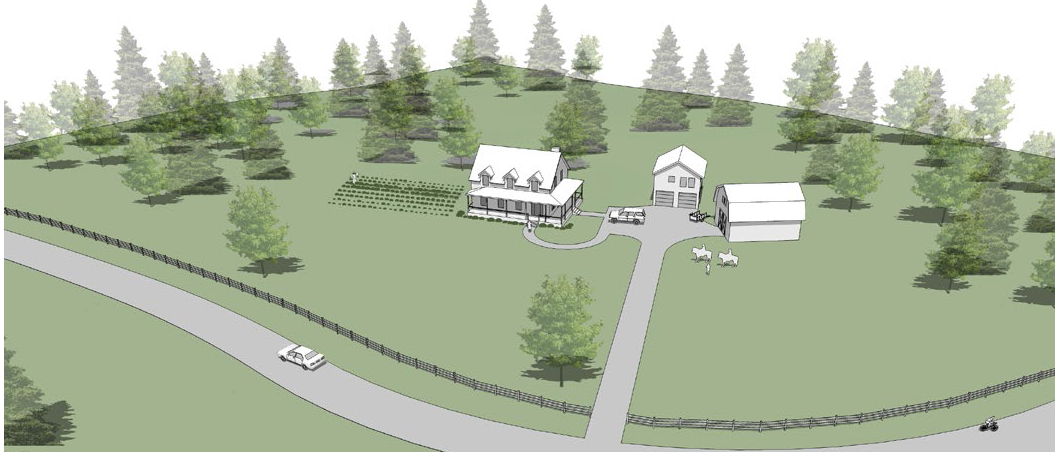
AG-43 is intended for agricultural and equestrian activity as well as single-family living in a detached house with a minimum lot size of 1 acre. Lots typically have access to and are served by a public water supply but do not necessarily have access to public sanitary sewer.
3.1.2. - RS-87: Single-Family Estate
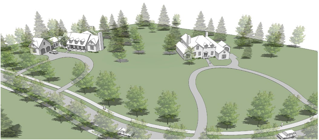
RS-87 is intended for single-family living in a detached house with a minimum lot size of 2 acres. Lots typically have access to and are served by a public water supply, but do not necessarily have access to public sanitary sewer. RS-87 implements the Estate Residential and Suburban Residential designations on the Future Development Map of the Comprehensive Plan.
3.1.3. - RS-30: Single-Family Estate
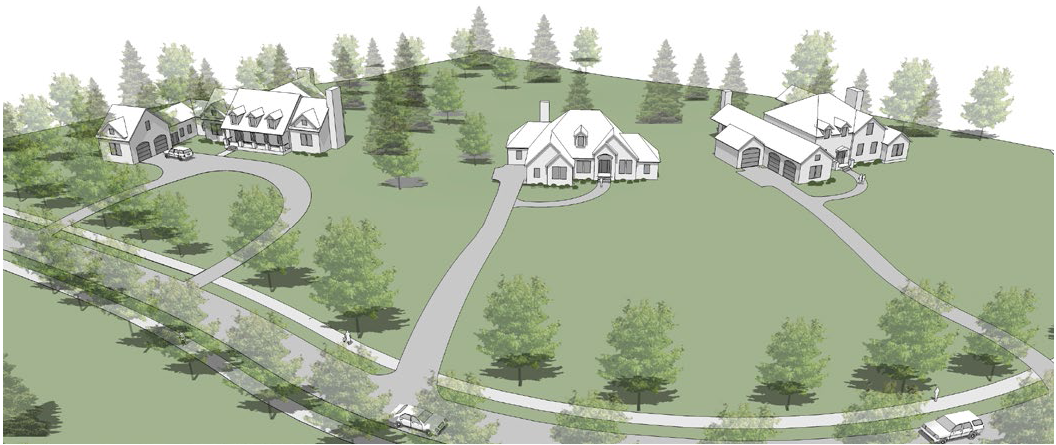
RS-30 is intended for single-family living in a detached house with a minimum lot size of 30,000 square feet. Lots typically have access to both public water supply and public sanitary sewer. RS-30 implements the Estate Residential and Suburban Residential designations on the Future Development Map of the Comprehensive Plan.
3.1.4. - RS-18: Single-Family Suburban
RS-18 is intended for single-family living in a detached house with a minimum lot size of 18,000 square feet. Lots have access to both public water supply and public sanitary sewer. RS-18 implements the Suburban Residential designation on the Future Development Map of the Comprehensive Plan.
3.1.5. - RS-12: Single-Family Suburban
RS-12 is intended for single-family living in a detached house with a minimum lot size of 12,000 square feet. Lots have access to both public water supply and public sanitary sewer. RS-12 implements the Suburban Residential designation on the Future Development Map of the Comprehensive Plan.
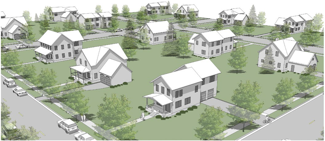
3.1.6. - RS-9: Single-Family Small Lot
RS-9 is intended for single-family living in a detached house with a minimum lot size of 9,000 square feet. Lots have access to both public water supply and public sanitary sewer. RS-9 is implements the Suburban Residential designation on the Future Development Map of the Comprehensive Plan.
3.1.7. - RS-6: Single-Family Small Lot
RS-6 is intended for single-family living in a detached house with a minimum lot size of 6,000 square feet. Lots have access to both public water supply and public sanitary sewer. RS- 6 implements the Highway 9/ Alpharetta Highway Corridor Commercial, Parkway Village District Overlay, GA 400/Holcomb Bridge Road Node, and Holcomb Bridge Road/SR 140, and Historic Area Town Center/Downtown designations on the Future Development Map of the Comprehensive Plan. RS-6 is allowed in other areas as defined by the Comprehensive Plan, only in exceptional situations. RS-6 is only suitable for pre-existing RS-6 sites or Transitional Parcels may be suitable for RS-6 only in exceptional situations.
3.1.8. - RS-4: Single Family Small Lot
RS-4 is intended for single-family living in a detached house with a minimum lot size of 4,000 square feet. Lots have access to both public water supply and public sanitary sewer. RS-4 implements the Highway 9/Alpharetta Highway Corridor Commercial, Parkway Village District Overlay, GA 400/Holcomb Bridge Road Node, and Holcomb Bridge Road/SR 140, and Historic Area Town Center/Downtown designations on the Future Development Map of the Comprehensive Plan. RS-4 is allowed in other areas as defined by the Comprehensive Plan, only in exceptional situations. RS-4 is only suitable for pre-existing RS-4 sites or preexisting R-TH sites or Transitional Parcels may be suitable for RS-4 only in exceptional situations.
3.1.9. - R-CC: Residential Cottage Court
R-CC is intended for single-family living in a detached house surrounding a common landscaped courtyard. Lots have access to both public water supply and public sanitary sewer. R-CC implements the Parkway Village District Overlay, Holcomb Bridge Road/SR 140, and Historic Area Town Center/Downtown designations on the Future Development Map of the Comprehensive Plan.
3.1.10. - R-TH: Residential Townhouse
R-TH is intended for residential living in a detached house, attached house, cottage court or townhouse. Lots have access to both public water supply and public sanitary sewer. R-TH implements the Parkway Village District Overlay, Holcomb Bridge Road/SR 140, and Historic Area Town Center/Downtown designations on the Future Development Map of the Comprehensive Plan.
3.1.11. - RM-2 Residential Multi-Family
RM-2 is intended for residential living in a detached house, attached house, cottage court, townhouse or walk-up flat. Lots have access to both public water supply and public sanitary sewer. RM-2 implements the Suburban Residential, Holcomb Bridge Road/SR 140, and Historic Area Town Center/Downtown designations on the Future Development Map of the Comprehensive Plan. In Suburban Residential, RM-2 is only suitable for pre-existing multi-family sites.
3.1.12. - RM-3: Residential Multi-Family
RM-3 is intended for residential living in a detached house, attached house, cottage court, townhouse, walk-up flat or stacked flat. Lots have access to both public water supply and public sanitary sewer. RM-3 implements the Suburban Residential, Highway 9/Alpharetta Highway Corridor Commercial, GA 400/Holcomb Bridge Road Node, Holcomb Bridge Road/SR 140, and Historic Area Town Center/Downtown designations on the Future Development Map of the Comprehensive Plan. In Suburban Residential, RM-3 is only suitable for pre-existing multi-family sites.
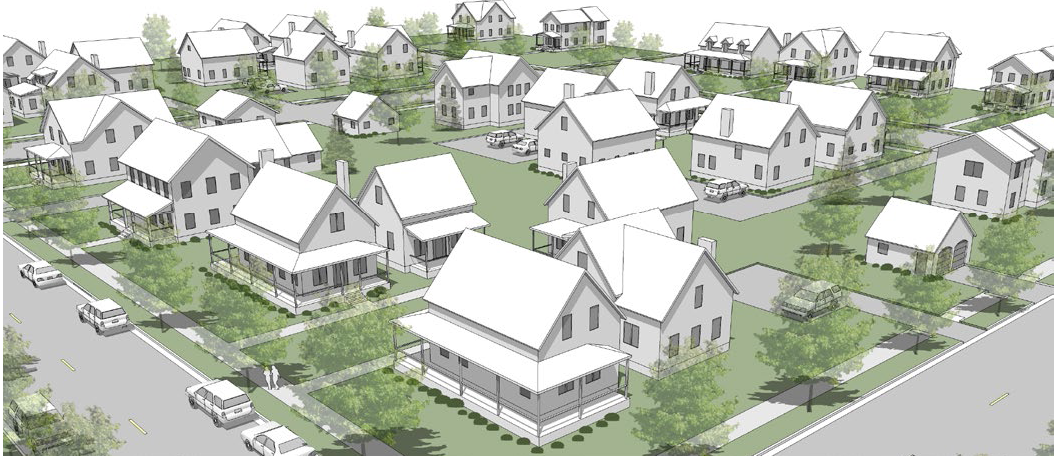
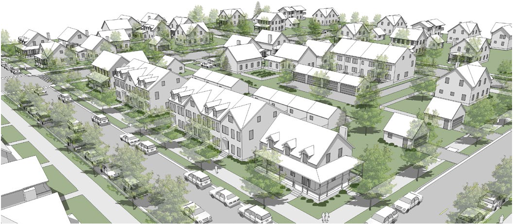
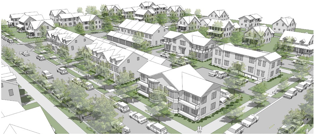
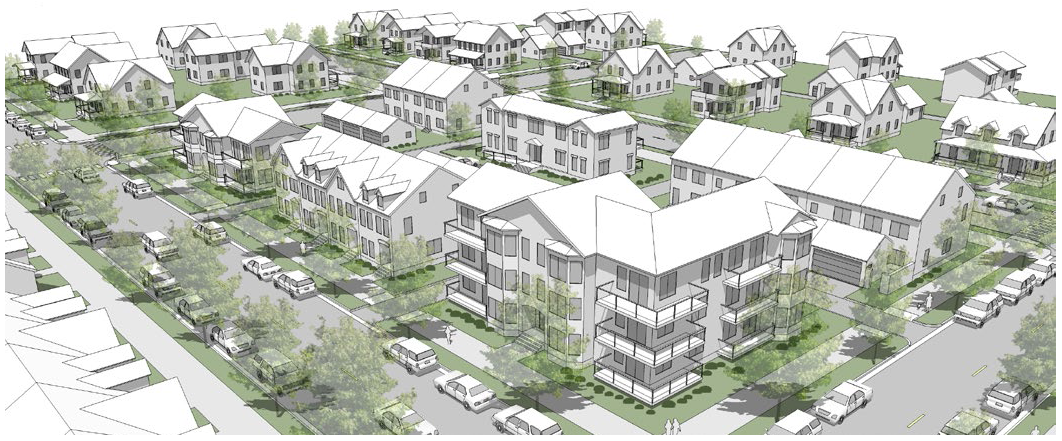
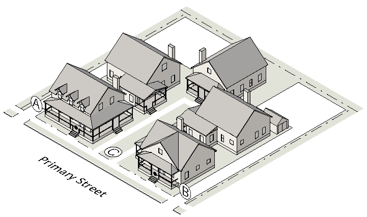
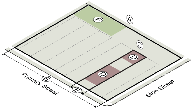
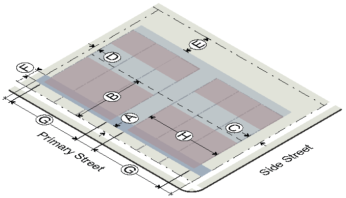
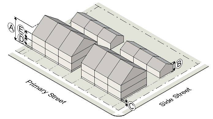
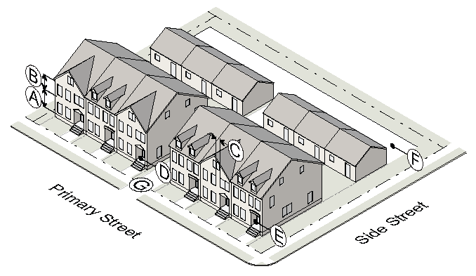
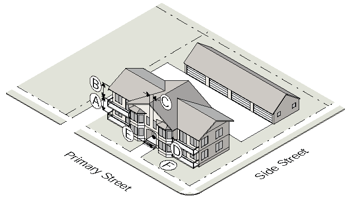
3.2.1. - Building Types Allowed by District
Building types (as defined in Sec. 2.1.) are allowed by district as shown below.
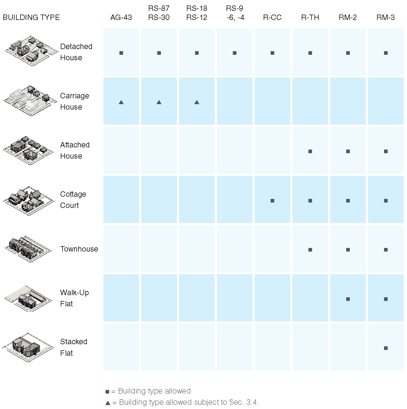
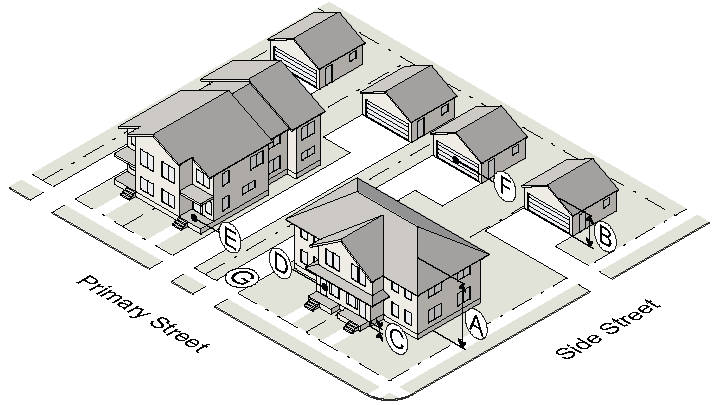
3.2.2. - Detached House (AG-43, RS-87, -30)
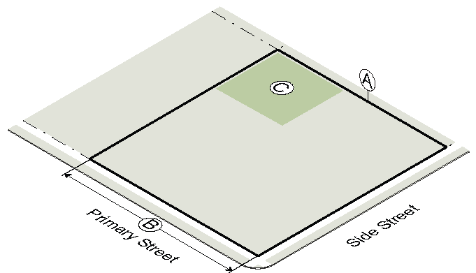
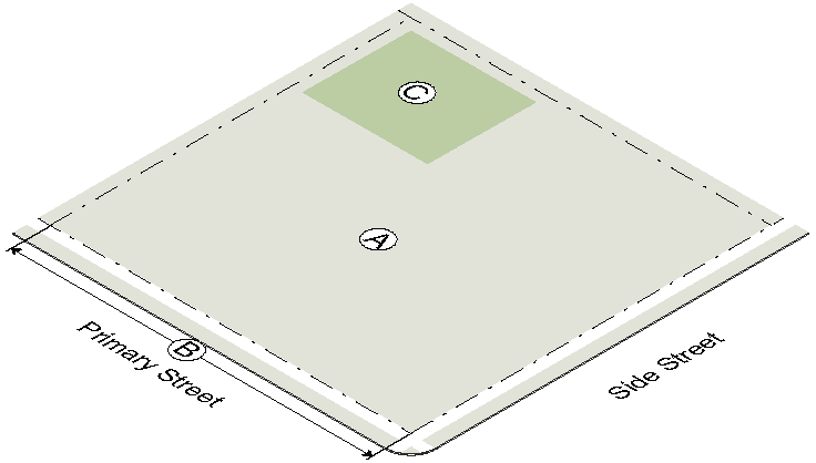
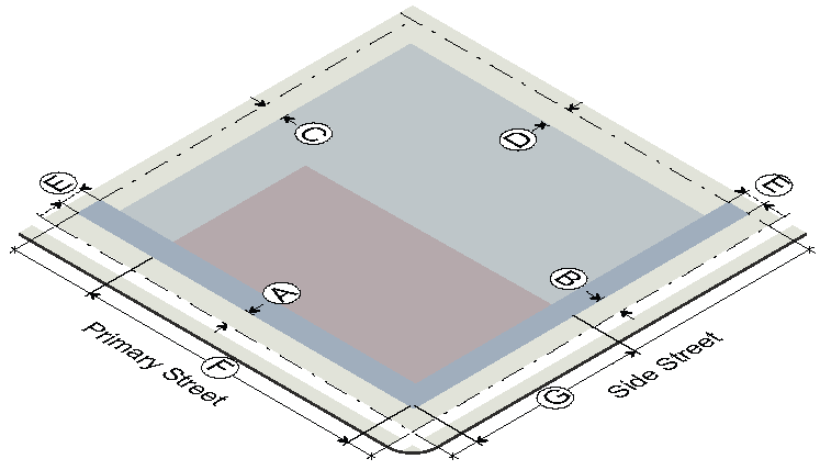
1. Lot and Placement
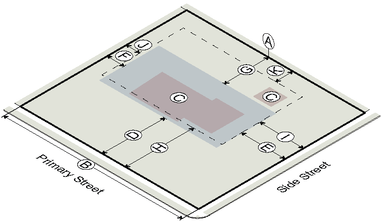
| AG-43 | RS-87 | RS-30 | |
| Lot Dimensions | |||
| Ⓐ Lot area (min) | 43,560 sf | 87,120 sf | 30,000 sf |
| Ⓑ Lot width (min) | 120' | 200' | 120' |
| Coverage | |||
| Ⓒ Building coverage (max) | 25% | 25% | 25% |
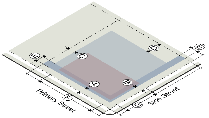
| Principal Building Setbacks | |||
| Ⓓ Primary street, major/minor (min) | 60'/50' | 60'/60' | 60'/50' |
| Ⓔ Side street, major/minor (min) | 35'/30' | 40'/35' | 35'/30' |
| Ⓕ Side interior (min) | 15' | 25' | 15' |
| Ⓖ Rear (min) | 40' | 50' | 40' |
| Accessory Structure Setbacks | |||
| Ⓗ Primary street, major/minor (min) | 70'/60' | 70'/70' | 70'/60' |
| Ⓘ Side street, major/minor (min) | 35'/30' | 40'/35' | 35'/30' |
| Ⓙ Side interior (min) | 15' | 15' | 15' |
| Ⓚ Rear (min) | 20' | 20' | 20' |
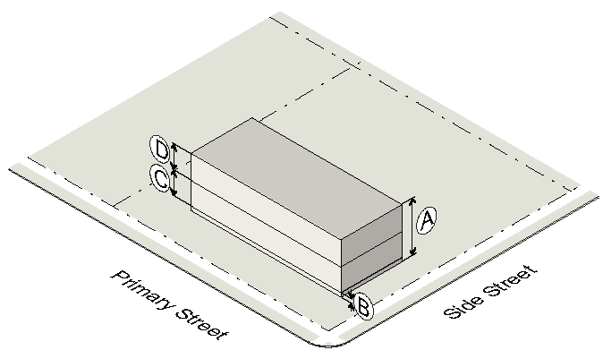
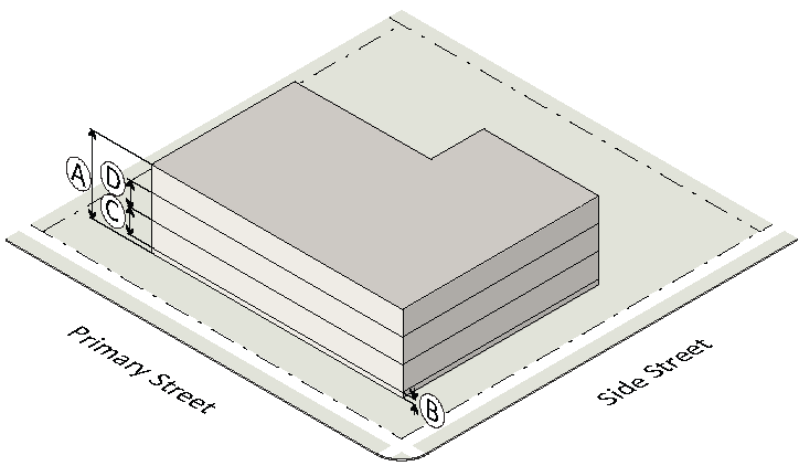
2. Scale and Activation
| AG-43 | RS-87 | RS-30 | |
| Building Height | |||
| Ⓐ Principal building (max) | 35' / 2½ stories | 35' / 2½ stories | 35' / 2½ stories |
| Ⓑ Accessory structure (max) | 24' | 24' | 24' |
| Permitted Building Elements | |||
| Ⓒ Front porch, stoop, balcony | Allowed | Allowed | Allowed |
| Vehicle Access | |||
| Ⓓ Garage door restrictions | n/a | n/a | see Sec. 2.2.19 |
| Ⓔ Front yard parking restrictions | n/a | n/a | see Sec. 2.2.20 |
3.2.3. - Detached House (RS-18, -12)
1. Lot and Placement
| RS-18 | RS-12 | |
| Lot Dimensions | ||
| Ⓐ Lot area (min) | 18,000 sf | 12,000 sf |
| Ⓑ Lot width (min) | 100' | 85' |
| Coverage | ||
| Ⓒ Building coverage (max) | 30% | 35% |
| Principal Building Setbacks | ||
| Ⓓ Primary street, major/minor (min) | 50'/40' | 40'/35' |
| Ⓔ Side street, major/minor (min) | 30'/25' | 25'/20' |
| Ⓕ Side interior (min) | 10' | 10' |
| Ⓖ Rear (min) | 35' | 30' |
| Accessory Structure Setbacks | ||
| Ⓗ Primary street, major/minor (min) | 60'/50' | 50'/45' |
| Ⓘ Side street, major/minor (min) | 30'/25' | 25'/20' |
| Ⓙ Side interior (min) | 10' | 10' |
| Ⓚ Rear (min) | 10' | 10' |
2. Scale and Activation
| RS-18 | RS-12 | |
| Building Height | ||
| Ⓐ Principal building (max) | 35' / 2½ stories | 35' / 2½ stories |
| Ⓑ Accessory structure (max) | 24' | 24' |
| Permitted Building Elements | ||
| Ⓒ Front porch, stoop, balcony | Allowed | Allowed |
| Vehicle Access | ||
| Ⓓ Garage door restrictions | see Sec. 2.2.19 | |
| Ⓔ Front yard parking restrictions | see Sec. 2.2.20 | |
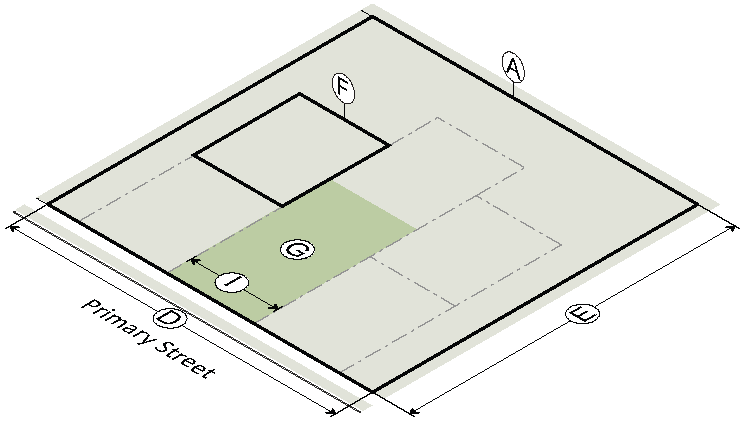
3.2.4. - Detached House (RS-9)
1. Lot and Placement
| RS-9 | |
| Subdivision | |
| Common open space (min) | 20% |
| Lot Parameters | |
| Ⓐ Lot area (min) | 9,000 sf |
| Ⓑ Lot width (min) | 60' |
| Ⓒ Building coverage (max) | 45% |
| Principal Building Setbacks | |
| Ⓓ Primary street (min) | 20' |
| Ⓔ Side street (min) | 20' |
| Ⓕ Side interior (min) | 7' |
| Ⓖ Rear (min) | 20' |
| Accessory Structure Setbacks | |
| Ⓗ Primary street (min) | 40' |
| Ⓘ Side street (min) | 20' |
| Ⓙ Side interior (min) | 10' |
| Ⓚ Rear (min) | 10' |
| Ⓚ Alley | 4' or 20' min |
2. Scale and Activation
| RS-9 | |
| Building Height | |
| Ⓐ Principal building (max) | 35' / 2½ stories |
| Ⓑ Accessory structure (max) | 24' |
| Ground Floor Elevation | |
| Ⓒ 20' or less from front property line (min) | 2' |
| Ⓒ More than 20' from front property line (min) | n/a |
| Pedestrian Access | |
| Ⓓ Entrance facing primary street | Required |
| Permitted Building Elements | |
| Ⓔ Front porch, stoop, balcony | Allowed |
| Vehicle Access | |
| Ⓕ Garage door restrictions | see Sec. 2.2.19 |
| Ⓖ Front yard parking restrictions | see Sec. 2.2.20 |
3.2.5. - Detached House (RS-6, -4, R-CC, R-TH, RM-2, -3)
1. Lot and Placement
| RS-6 |
RS-4,
R-CC, R-TH, RM-2, -3 | |
| Subdivision | ||
| Common open space (min) | 20% | 20% |
| Lot Parameters | ||
| Ⓐ Lot area (min) | 6,000 sf | 6,000 sf |
| Ⓐ Lot area, alley-loaded (min) | — | 4,000 sf |
| Ⓑ Lot width (min) | 50' | 50' |
| Ⓑ Lot width, alley-loaded (min) | — | 40' |
| Ⓒ Building coverage (max) | 55% | 60% |
| Principal Building Setbacks | ||
| Ⓓ Primary street (min) | 20' | 15' |
| R-TH, RM-2, RM-3 | — | 10' |
| Ⓔ Side street (min) | 20' | 15' |
| R-TH, RM-2, RM-3 | — | 10' |
| Ⓕ Side interior (min) | 7' | 5' |
| Ⓖ Rear (min) | 20' | 20' |
| Accessory Structure Setbacks | ||
| Ⓗ Primary street (min) | 40' | 40' |
| Ⓘ Side street (min) | 20' | 15' |
| Ⓙ Side interior (min) | 10' | 10' |
| Ⓚ Rear (min) | 10' | 10' |
| Ⓚ Alley | 4' or 20' min | 4' or 20' min |
2. Scale and Activation
| RS-6 |
RS-4,
R-CC, R-TH, RM-2, -3 | |
| Building Height | ||
| Ⓐ Principal building (max) | 35' / 2½ stories | 35' / 2½ stories |
| Ⓑ Accessory structure (max) | 24' | 24' |
| Ground Floor Elevation | ||
| Ⓒ 20' or less from front property line (min) | 2' | 2' |
| Ⓒ More than 20' from front property line (min) | n/a | n/a |
| Pedestrian Access | ||
| Ⓓ Entrance facing primary street | Required | Required |
| Permitted Building Elements | ||
| Ⓔ Front porch, stoop, balcony | Allowed | Allowed |
| Vehicle Access | ||
| Ⓕ Garage door restrictions | see Sec. 2.2.19 | |
| Ⓖ Front yard parking restrictions | see Sec. 2.2.20 | |
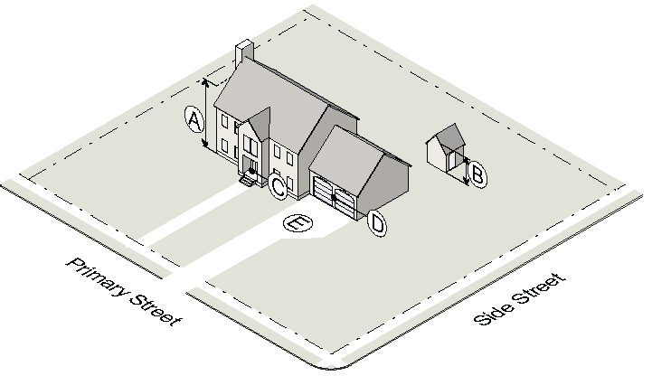
3.2.6. - Carriage House (AG-43, RS-87, -30, -18, -12)
1. Lot and Placement
|
AG-43
RS-87 RS-30 |
RS-18
RS-12 | |
| Lot Dimensions | ||
| Ⓐ Lot area (min) | same as principal | same as principal |
| Ⓑ Lot width (min) | same as principal | same as principal |
| Ⓒ Lot depth (min) | 150' | 150' |
| Coverage | ||
| Ⓓ Building coverage (max) | same as principal | same as principal |
| Ⓔ Conditioned space (max) | 1,000 sf | 700 sf |
| Ⓕ Building separation (min) | 20' | 20' |
| Building Setbacks | ||
| Ⓖ Primary street (min) | 70' | 60' |
| Ⓗ Side street (min) | 40' | 30' |
| Ⓘ Side interior (min) | 15' | 10' |
| Ⓙ Rear (min) | 20' | 15' |
| Ⓙ Alley | n/a | n/a |
2. Scale and Activation
|
RS-87
RS-30 |
RS-18
RS-12 | |
| Building Height | ||
| Ⓐ Height (max) | 24' | 24' |
| Ⓑ Wall plate height (max) | n/a | n/a |
| Vehicle Access | ||
| Ⓒ Additional on-site parking (min) | 1 space | 1 space |
| Ⓓ Garage door restrictions | see Sec. 2.2.19 | |
(Ord. No. 2023-04-08, § 1, 4-24-2023)
3.2.7. - Attached House
1. Lot and Placement
| Lot Dimensions | |
| Ⓐ Lot area per unit (min) | 5,500 sf |
| Ⓐ Lot area per unit, alley-loaded (min) | 3,000 sf |
| Ⓑ Lot width (min) | 50' |
| Ⓑ Lot width, alley-loaded (min) | 30' |
| Coverage | |
| Ⓒ Building coverage (max) | 70% |
| Principal Building Setbacks | |
| Ⓓ Primary street (min) | 15' |
| R-TH, RM-2, RM-3 | 10' |
| Ⓔ Side street (min) | 15' |
| R-TH, RM-2, RM-3 | 10' |
| Ⓕ Side interior (min) | 5' |
| Ⓖ Rear (min) | 20' |
| Accessory Structure Setbacks | |
| Ⓗ Primary street (min) | 40' |
| Ⓘ Side street (min) | 15' |
| Ⓙ Side interior (min) | 5' |
| Ⓚ Rear (min) | 10' |
| Ⓚ Alley | 4' or 20' min |
2. Scale and Activation
| Building Height | |
| Ⓐ Principal building (max) | 35' / 2½ stories |
| Ⓑ Accessory structure (max) | 24' |
| Ground Floor Elevation | |
| Ⓒ 20' or less from front property line (min) | 2' |
| Ⓒ More than 20' from front property line (min) | n/a |
| Pedestrian Access | |
| Ⓓ Entrance facing primary street | Required |
| Permitted Building Elements | |
| Ⓔ Front porch, stoop, balcony | Allowed |
| Vehicle Access | |
| Ⓕ Garage door restrictions | see Sec. 2.2.19 |
| Ⓖ Front yard parking restrictions | see Sec. 2.2.20 |
3.2.8. - Cottage Court
1. Lot
| Site Dimensions | |
| Ⓐ Site area (min) | 22,500 sf |
| Ⓑ Site area per unit (min) | 4,500 sf |
| Ⓒ Units per site (min/max) | 5/9 |
| Ⓓ Site width (min) | 150' |
| Ⓔ Site depth (min) | 150' |
| Lot Dimensions | |
| Ⓕ Lot area (min) | 1,200 sf |
| Coverage | |
| Building coverage (max) | 60% |
| Courtyard | |
| Ⓖ Area (min) | 3,000 sf |
| Ⓗ Courtyard area per unit (min) | 600 sf |
| Ⓘ Width (min) | 40' |
| A cottage lot abutting a courtyard that meets the above standards meets the platting requirements for frontage on an improved public street. | |
2. Placement
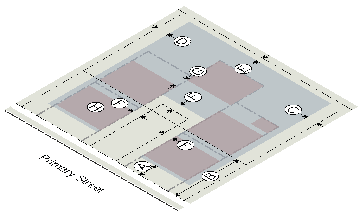
| Building Setbacks | |
| Ⓐ Primary street - principal buildings (min) | 15' |
| R-TH, RM-2, RM-3 | 10' |
| Ⓑ Primary street - accessory structures (min) | 30' |
| Ⓒ Side street (min) | 15' |
| R-TH, RM-2, RM-3 | 10' |
| Ⓓ Side interior (min) | 5' |
| Ⓔ Rear (min) | 10' |
| Ⓕ Alley | 4' or 20' min |
| Courtyard Encroachment | |
| Ⓕ Porch including steps (max) | 6' |
| Ⓕ Balcony (max) | 6' |
| Placement Limitations | |
| Ⓖ Building separation (min) | 6' |
| Ⓗ Principal building footprint (max) | 1,200 sf |
3. Scale
| Building Height | |
| Ⓐ Principal building - height (max) | 24' / 1½ stories |
| Ⓑ Principal building - wall plate height (max) | 18' |
| Ⓒ Accessory structure - height (max) | 18' |
| Ground Floor Elevation | |
| Ⓓ Ground floor elevation (min) | 2' |
4. Activation
| Pedestrian Access | |
| Ⓐ Entrance facing primary street | Required for end units |
| Permitted Building Elements | |
| Ⓑ Front porch, stoop, balcony | Allowed |
| Vehicle Access | |
| Ⓒ No parking between the building and the street | |
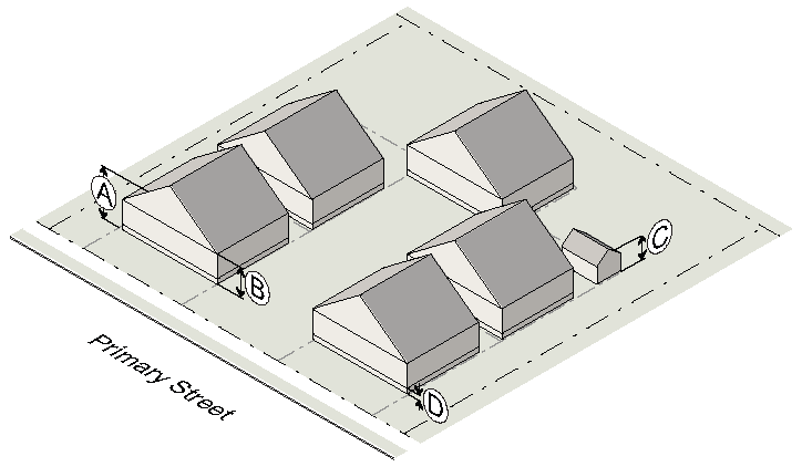
3.2.9. - Townhouse
1. Lot
| Site Dimensions | |
| Ⓐ Site area (min) | 6,000 sf |
| Ⓑ Site width (min) | 70' |
| Lot Dimensions | |
| Ⓒ Lot area (min) | 1,500 sf |
| Ⓓ Building coverage (max) | 75% |
| Ⓔ Unit width (min) | 20' |
| Site Parameters | |
| Ⓕ Landscape Open Space (min) | 40% |
2. Placement
| Building Setbacks | |
| Ⓐ Primary street - principal buildings (min) | 10' |
| Ⓑ Primary street - accessory structures (min) | 40' |
| Ⓒ Side street (min) | 10' |
| Ⓓ Side interior (min) | 5' |
| Ⓔ Rear (min) | 20' |
| Ⓔ Alley | 4' or 20' min |
| Build-to Zone (BTZ) | |
| Ⓕ Primary street (min/max) | 10'/20' |
| Ⓖ Building in primary street BTZ (min % of lot width) | 70% |
| Building Length | |
| Ⓗ R-TH: Number of units permitted in any one row (max) |
4 Rear-Loaded
10' min building separation |
3. Scale
| Building Height | |
| Ⓐ Principal building (max) | |
| R-TH, RM-2 | 35' / 2½ stories |
| RM-3 | 45' / 3½ stories |
| Reduced height may be required when abutting a protected district (see Sec. 3.3.) | |
| Ⓑ Accessory structure (max) | 24' |
| Ground Floor Elevation | |
| Ⓒ Ground floor elevation (min) | 2' |
| Story Height | |
| Ⓓ Ground story height, floor to ceiling (min) | 9' |
| Ⓔ Upper story height, floor to ceiling (min) | 9' |
4. Activation
| Transparency | |
| Ⓐ Ground story, primary/side street (min) | 20% |
| Ⓑ Upper story, primary/side street (min) | 20% |
| Ⓒ Blank wall area, primary/side street (max) | 30' |
| Pedestrian Access | |
| Ⓓ Entrance facing primary street (each ground floor unit) | Required |
| Permitted Building Elements | |
| Ⓔ Front porch, stoop, balcony, forecourt | Allowed |
| Vehicle Access | |
| Ⓕ Parking location options | see Sec. 2.2.19 |
| Ⓖ Front yard parking restrictions | see Sec. 2.2.20 |
(Ord. No. 2023-03-04, § 3, 3-27-2023; Ord. No. 2023-03-05, § 8, 3-27-2023)
3.2.10. - Walk-Up Flat
1. Lot
| Lot Dimensions | |
| Ⓐ Lot area (min) | 12,500 sf |
| Ⓑ Lot width (min) | 100' |
| Lot Parameters | |
| Ⓒ Landscape open space (min) | 45% |
| Ⓓ Dwelling units per building (max) | 8 |
2. Placement
| Building Setbacks | |
| Ⓐ Primary street (min) | 10' |
| Ⓑ Side street (min) | 10' |
| Ⓒ Side interior (min) | 10' |
| Ⓓ Rear (min) | 20' |
| Ⓓ Alley (min) | 5' |
| Build-to Zone (BTZ) | |
| Ⓔ Primary/side street (min/max) | 10'/20' |
| Ⓕ Building in primary street BTZ (min % of lot width) | 70% |
| Ⓖ Building in side street BTZ (min % of lot width) | 35% |
3. Scale
| Building Height | |
| Ⓐ Building height (max) | 35' / 2½ stories |
| Ground Floor Elevation | |
| Ⓑ Ground floor elevation (min) | 2' |
| Story Height | |
| Ⓒ Ground story height, floor to ceiling (min) | 9' |
| Ⓓ Upper story height, floor to ceiling (min) | 9' |
4. Activation
| Transparency | |
| Ⓐ Ground story, primary/side street (min) | 20% |
| Ⓑ Upper story, primary/side street (min) | 20% |
| Ⓒ Blank wall area, primary/side street (max) | 30' |
| Pedestrian Access | |
| Ⓓ Entrance facing primary street | Required |
| Permitted Building Elements | |
| Ⓔ Front porch, stoop, balcony, forecourt | Allowed |
| Vehicle Access | |
| Ⓕ No parking between the building and the street | |
(Ord. No. 2023-03-04, § 4, 3-27-2023)
3.2.11. - Stacked Flat
1. Lot
| Lot Dimensions | |
| Ⓐ Lot area (min) | 17,500 sf |
| Ⓑ Lot width (min) | 100' |
| Lot Parameters | |
| Ⓒ Landscape open space (min) | 45% |
2. Placement
| Building Setbacks | |
| Ⓐ Primary street (min) | 10' |
| Ⓑ Side street (min) | 10' |
| Ⓒ Side interior (min) | 10' |
| Ⓓ Rear (min) | 10 |
| Ⓓ Alley (min) | 5' |
| Build-to Zone (BTZ) | |
| Ⓔ Primary/side street (min/max) | 10'/20' |
| Ⓕ Building in primary street BTZ (min % of lot width) | 70% |
| Ⓖ Building in side street BTZ (min % of lot width) | 35% |
3. Scale
| Building Height | |
| Ⓐ Building height (max) | 45' / 3½ stories |
| An additional 2 stories may be allowed through the conditional use process (see Sec. 13.4.). | |
| Reduced height may be required when abutting a protected district (see Sec. 3.3.) | |
| Ground Floor Elevation | |
| Ⓑ Ground floor elevation (min) | 2' |
| Story Height | |
| Ⓒ Ground story height, floor to ceiling (min) | 9' |
| Ⓓ Upper story height, floor to ceiling (min) | 9' |
4. Activation
| Transparency | |
| Ⓐ Ground story, primary/side street (min) | 20% |
| Ⓑ Upper story, primary/side street (min) | 20% |
| Ⓒ Blank wall area, primary/side street (max) | 30' |
| Pedestrian Access | |
| Ⓓ Entrance facing primary street | Required |
| Ⓔ Entrance spacing along primary street (max) | 150' |
| Permitted Building Elements | |
| Ⓕ Front porch, stoop, balcony, awning/canopy, forecourt | Allowed |
| Vehicle Access | |
| Ⓖ No parking between the building and the street | |
(Ord. No. 2023-03-04, § 5, 3-27-2023)
3.3.1. - Applicability
Neighborhood compatibility measures are required when indicated in the table in Sec. 10.2.3.
3.3.2. - Landscape Buffers
A landscape buffer is required when indicated in the table in Sec. 10.2.3
3.3.3. - Building Setbacks
Where a neighborhood compatibility buffer applies, all building and structure setbacks are measured from the interior edge of the landscape buffer. In no case can a building be placed less than 10 feet from the interior edge of the buffer.
3.3.4. - Bulk Plane
A.
A building must not extend into a 30-degree angular plane projecting over the subject property measured from a height of 35 feet at the side interior or rear setback line. Setbacks are measured from the interior edge of the landscape buffer.
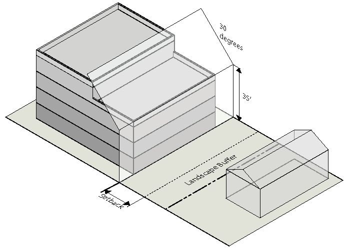
B.
The bulk plane ends at any public street (not including an alley) or 150 feet from the protected district property line, whichever is less.
3.4.1. - Use Categories
A.
In order to regulate a variety of similar uses, use categorizes have been established for principal uses. Use definitions and limited use standards for both principal and accessory uses are specified in Article 9. Uses not listed may be interpreted by the Zoning Director under Sec. 9.1.2.
B.
Principal and accessory uses allowed by district are shown in the table below.
3.4.2. - Use Table
A.
Permitted Use (P). Indicates a use is permitted in the respective district. The use is also subject to all other applicable requirements of this UDC.
B.
Limited Use (L). Indicates a use is permitted in the respective district, subject to a use standard found in the right-hand column of the use table. The use is also subject to all other applicable requirements of this UDC.
C.
Conditional Use (C). Indicates a use may be permitted in the respective district only where approved by the City Council in accordance with Sec. 13.4. Conditional uses are subject to all other applicable requirements of this UDC, including any applicable use standards, except where the use standards are expressly modified by the Mayor and City Council as part of the conditional use permit approval.
D.
Use Not Permitted. A "—" in a cell indicates that a use is not permitted in the respective district.
|
Use Category
Specific Use | RESIDENTIAL |
Definition/
Standards | |||||||||||
|---|---|---|---|---|---|---|---|---|---|---|---|---|---|
| AG-43 | RS-87 | RS-30 | RS-18 | RS-12 | RS-9 | RS-6 | RS-4 | R-CC | R-TH | RM-2 | RM-3 | ||
| Open Uses | |||||||||||||
| All agriculture, as listed below: | 9.2.1.A. | ||||||||||||
| Community garden | L | L | L | L | L | L | L | L | L | L | L | L | 9.2.1.B. |
| Timber harvesting | P | — | — | — | — | — | — | — | — | — | — | — | 9.2.1.C. |
| Urban farm | L | L | C | — | — | — | — | — | — | — | — | — | 9.2.1.D. |
| Residential Uses | |||||||||||||
| All household living, as listed below: | 9.3.1.A. | ||||||||||||
| Single-family | P | P | P | P | P | P | P | P | P | P | P | P | 9.3.1.B. |
| Two-family | — | — | — | — | — | — | — | — | — | P | P | P | 9.3.1.C. |
| Townhouse | — | — | — | — | — | — | — | — | — | P | P | P | 9.3.1.D. |
| Multi-family/Apartment | — | — | — | — | — | — | — | — | — | — | C | C | 9.3.1.E. |
| Multi-family/Condominium | — | — | — | — | — | — | — | — | — | — | C | C | 9.3.1 E. |
| Manufactured home | — | — | — | — | — | — | — | — | — | — | — | C | 9.3.1.F. |
| All group living, as listed below: | 9.3.2.A. | ||||||||||||
| Continuing care retirement community | — | — | — | — | — | — | — | — | — | — | — | — | 9.3.2.B. |
| Group home | L | L | L | L | L | L | L | L | L | L | L | L | 9.3.2.C. |
| Hospice | — | — | — | — | — | — | — | — | — | — | — | — | 9.3.2.D. |
| Institutional residential (up to 18 residents) | — | — | — | — | — | — | — | — | — | — | C | C | 9.3.2.E. |
| Institutional residential (more than 18 residents) | — | — | — | — | — | — | — | — | — | — | C | C | 9.3.2.E. |
| Monastery, convent | — | — | — | — | — | — | — | — | — | — | — | — | 9.3.2.F. |
| Rooming house | — | — | — | — | — | — | — | — | — | — | — | — | 9.3.2.G. |
| All social service and educational | — | — | — | — | — | — | — | — | — | — | — | — | 9.3.3.A. |
| Public/Institutional Uses | |||||||||||||
| All civic, as listed below: | 9.4.1.A. | ||||||||||||
| College, university | — | — | — | — | — | — | — | — | — | — | — | — | 9.4.1.B. |
| Club or lodge, nonprofit | — | — | — | — | — | — | — | — | — | — | — | — | 9.4.1.C. |
| Museum, library | — | — | — | — | — | — | — | — | — | — | — | — | 9.4.1.D. |
| Nonprofit service organization | — | — | — | — | — | — | — | — | — | — | — | — | 9.4.1.E. |
| Place of worship | — | — | — | — | — | — | — | — | — | — | — | — | 9.4.1.F. |
| Public use | — | — | — | — | — | — | — | — | — | — | — | — | 9.4.1.G. |
| School, private (K-12) | — | — | — | — | — | — | — | — | — | — | — | — | 9.4.1.H. |
| School, public (K-12) | — | — | — | — | — | — | — | — | — | — | — | — | 9.4.1.I. |
| School, special | — | — | — | — | — | — | — | — | — | — | — | — | 9.4.1.J. |
| All parks and open space, as listed below: | 9.4.2.A. | ||||||||||||
| Cemetery | — | — | — | — | — | — | — | — | — | — | — | — | 9.4.2.B. |
| Community recreation | L | L | L | L | L | L | L | L | L | L | L | L | 9.4.2.C. |
| Conservation area | P | P | P | P | P | P | P | P | P | P | P | P | 9.4.2.D. |
| Golf course | — | — | — | — | — | — | — | — | — | — | — | — | 9.4.2.E. |
| Park, recreation field (up to 2 acres) | P | P | P | P | P | P | P | P | P | P | P | P | 9.4.2.F. |
| Park, recreation field (more than 2 acres) | — | — | — | — | — | — | — | — | — | — | — | — | 9.4.2.F. |
| Reservoir, water supply, water well | P | P | P | P | P | P | P | P | P | P | P | P | 9.4.2.G. |
| All major utilities, except as listed below | — | — | — | — | — | — | — | — | — | — | — | — | 9.4.3.A. |
| Telecommunication tower | L | — | — | — | — | — | — | — | — | — | — | — | 9.4.3.B. |
| All minor utilities | L | L | L | L | L | L | L | L | L | L | L | L | 9.4.4.A./B. |
| Commercial Uses | |||||||||||||
| All day care, as listed below: | 9.5.1.A. | ||||||||||||
| Adult care center (up to 4 aging adults) | — | L | L | L | L | L | L | L | L | L | L | L | 9.5.1.B. |
| Adult care center (more than 4 aging adults) | — | — | — | — | — | — | — | — | — | — | — | — | 9.5.1.B. |
| Day care center | — | — | — | — | — | — | — | — | — | — | — | — | 9.5.1.C. |
| All indoor recreation, except as listed below: | — | — | — | — | — | — | — | — | — | — | — | — | 9.5.2.A. |
| Adult business | — | — | — | — | — | — | — | — | — | — | — | — | 9.5.2.B. |
| Gym, health spa, yoga studio | — | — | — | — | — | — | — | — | — | — | — | — | 9.5.2.C. |
| School of the arts | — | — | — | — | — | — | — | — | — | — | — | — | 9.5.2.D. |
| Shooting range | — | — | — | — | — | — | — | — | — | — | — | — | 9.5.2.E. |
| Special event facility | — | — | — | — | — | — | — | — | — | — | — | — | 9.5.2.F. |
| All medical | — | — | — | — | — | — | — | — | — | — | — | — | 9.5.3.A. |
| All office, except as listed below: | — | — | — | — | — | — | — | — | — | — | — | — | 9.5.4.A. |
| Bail bonds | — | — | — | — | — | — | — | — | — | — | — | — | 9.5.4.B. |
| Call center | — | — | — | — | — | — | — | — | — | — | — | — | 9.5.4.C. |
| Radio, TV station, recording studio | — | — | — | — | — | — | — | — | — | — | — | — | 9.5.4.D. |
| Trade, vocational, business school | — | — | — | — | — | — | — | — | — | — | — | — | 9.5.4.E. |
| All outdoor recreation, except as listed below: | — | — | — | — | — | — | — | — | — | — | — | — | 9.5.5.A. |
| Golf driving range | L | — | C | — | — | — | — | — | — | — | — | — | 9.5.5.B. |
| Riding stable | L | L | C | — | — | — | — | — | — | — | — | — | 9.5.5.C. |
| Rowing club, boat rental | — | — | — | — | — | — | — | — | — | — | — | — | 9.5.5.D. |
| All overnight lodging, as listed below: | 9.5.6.A. | ||||||||||||
| Bed and breakfast (up to 6 rooms) | — | — | — | — | — | — | — | — | — | — | — | — | 9.5.6.B. |
| Boutique hotel (7 to 30 rooms) | — | — | — | — | — | — | — | — | — | — | — | — | 9.5.6.C. |
| Hotel/motel (more than 30 rooms) | — | — | — | — | — | — | — | — | — | — | — | — | 9.5.6.E. |
| All parking, as listed below: | 9.5.7.A. | ||||||||||||
| Commercial parking | — | — | — | — | — | — | — | — | — | — | — | — | 9.5.7.B. |
| Remote parking | — | — | — | — | — | — | — | — | — | — | — | — | 9.5.7.C. |
| All personal service, except as listed below: | — | — | — | — | — | — | — | — | — | — | — | — | 9.5.8.A./D. |
| Animal care (indoor) | — | — | — | — | — | — | — | — | — | — | — | — | 9.5.8.B. |
| Animal care (outdoor) | — | — | — | — | — | — | — | — | — | — | — | — | 9.5.8.C. |
| All restaurants | — | — | — | — | — | — | — | — | — | — | — | — | 9.5.9.A./C. |
| All retail sales, except as listed below: | — | — | — | — | — | — | — | — | — | — | — | — | 9.5.10.A./G. |
| Art gallery | — | — | — | — | — | — | — | — | — | — | — | — | 9.5.10.B. |
| Convenience store w/ gas pumps | — | — | — | — | — | — | — | — | — | — | — | — | 9.5.10.C. |
| Convenience store w/o gas pumps | — | — | — | — | — | — | — | — | — | — | — | — | 9.5.10.D. |
| Pawnshop | — | — | — | — | — | — | — | — | — | — | — | — | 9.5.10.E. |
| Title loans, check cashing | — | — | — | — | — | — | — | — | — | — | — | — | 9.5.10.F. |
| All vehicle sales/rental, as listed below: | 9.5.11.A. | ||||||||||||
| Vehicle rental | — | — | — | — | — | — | — | — | — | — | — | — | 9.5.11.B. |
| Vehicle sales and leasing, new | — | — | — | — | — | — | — | — | — | — | — | — | 9.5.11.C. |
| Vehicle sales and leasing, used | — | — | — | — | — | — | — | — | — | — | — | — | 9.5.11.D. |
| Vehicle storage | — | — | — | — | — | — | — | — | — | — | — | — | 9.5.11.E. |
| Industrial Uses | |||||||||||||
| All light industrial, except as listed below: | — | — | — | — | — | — | — | — | — | — | — | — | 9.6.1.A. |
| Contractors storage | — | — | — | — | — | — | — | — | — | — | — | — | 9.6.1.C. |
| Detention center, jail, prison (private) | — | — | — | — | — | — | — | — | — | — | — | — | 9.6.1.D. |
| Microbrewery | — | — | — | — | — | — | — | — | — | — | — | — | 9.6.1.F. |
| All light manufacturing | — | — | — | — | — | — | — | — | — | — | — | — | 9.6.2.A. |
| All research and development | — | — | — | — | — | — | — | — | — | — | — | — | 9.6.3.A. |
| All self-service storage | — | — | — | — | — | — | — | — | — | — | — | — | 9.6.4.A. |
| All vehicle service and repair, as listed below: | 9.6.5.A. | ||||||||||||
| Car wash | — | — | — | — | — | — | — | — | — | — | — | — | 9.6.5.B. |
| Vehicle repair, minor | — | — | — | — | — | — | — | — | — | — | — | — | 9.6.5.C. |
| Vehicle repair, major | — | — | — | — | — | — | — | — | — | — | — | — | 9.6.5.D. |
| Vehicle repair, commercial vehicle | — | — | — | — | — | — | — | — | — | — | — | — | 9.6.5.E. |
| All warehouse and distribution | — | — | — | — | — | — | — | — | — | — | — | — | 9.6.6.A. |
| Accessory Uses | |||||||||||||
| Accessory uses not otherwise listed below, as determined by the Zoning Director: | P | P | P | P | P | P | P | P | P | P | P | P | Sec. 9.1.3 |
| Accessory apartment, attached | C | L | L | L | L | — | — | — | — | — | — | — | Sec. 9.7.1 |
| Carriage house (existing lot) | C | C | C | C | C | — | — | — | — | — | — | — | Sec. 9.7.2 |
| Carriage house (lot subdivided after effective date of this code) | C | C | C | C | C | — | — | — | — | — | — | — | Sec. 9.7.2 |
| Car wash | — | — | — | — | — | — | — | — | — | — | — | — | Sec. 9.7.3 |
| Donation bin | — | — | — | — | — | — | — | — | — | — | — | L | Sec. 9.7.4 |
| Drive-thru facility | — | — | — | — | — | — | — | — | — | — | — | — | Sec. 9.7.5 |
| Family day care home | L | L | L | L | L | L | L | L | L | L | L | L | Sec. 9.7.6 |
| Farmers' Market | — | — | — | — | — | — | — | — | — | — | — | — | Sec. 9.7.7 |
| Garden | L | L | L | L | L | L | L | L | L | L | L | L | Sec. 9.7.8 |
| Greenhouse, non-commercial | P | P | P | P | P | P | P | P | P | P | P | P | Sec. 9.7.9 |
| Helicopter landing area | — | — | — | — | — | — | — | — | — | — | — | — | Sec. 9.7.10 |
| Home occupation | L | L | L | L | L | L | L | L | L | L | L | L | Sec. 9.7.11 |
| Horse stable, non-commercial | L | L | L | — | — | — | — | — | — | — | — | — | Sec. 9.7.12 |
| Kennel, hobby | L | L | C | — | — | — | — | — | — | — | — | — | Sec. 9.7.13 |
| Livestock raising | L | L | L | — | — | — | — | — | — | — | — | — | Sec. 9.7.14 |
| Outdoor dining | — | — | — | — | — | — | — | — | — | — | — | — | Sec. 9.7.15 |
| Outdoor display | — | — | — | — | — | — | — | — | — | — | — | — | Sec. 9.7.16 |
| Outdoor kitchen | P | P | P | P | P | P | P | P | P | P | L | L | Sec. 9.7.17 |
| Outdoor storage, limited | — | — | — | — | — | — | — | — | — | — | — | — | Sec. 9.7.18 |
| Outdoor storage, general | — | — | — | — | — | — | — | — | — | — | — | — | Sec. 9.7.19 |
| Parking, on-site | P | P | P | P | P | P | P | P | P | P | P | P | Sec. 9.7.21 |
| Poultry raising | L | L | L | L | L | L | L | L | L | L | L | L | Sec. 9.7.22 |
| Recreational vehicle parking | L | L | L | L | L | L | L | L | L | L | L | L | Sec. 9.7.23 |
| Solar panels, wind turbines, rainwater collection systems | P | P | P | P | P | P | P | P | P | P | P | P | Sec. 9.7.24 |
| Swimming pool | L | L | L | L | L | L | L | L | L | L | L | L | Sec. 9.7.25 |
Key: P = Permitted Use
L = Limited Use
C = Conditional Use
— = Use Not Permitted
(Ord. No. 2022-07-07, § 1, 7-11-2022)
3.5.1. - Purpose
The purpose of the Planned Residential Development (PRD) is to:
A.
Allow one or more properties to be planned as a unit with development standards tailored to the site.
B.
Provide maximum flexibility and diversification in the development of the property.
C.
Maintain consistency with the 2030 Comprehensive Plan and all subsequent amendments and updates.
D.
Protect the integrity and character of residential uses of the City.
E.
Encourage efficient use of land for preservation of sensitive environmental areas such as open space areas and topographic features.
F.
Provide for effective development of public facilities and services for the site.
G.
Encourage use of design features to achieve development that is compatible with the area.
H.
Allow for creative and imaginative design that will promote amenities beyond those expected in conventional developments.
3.5.2. - Intent
The intent of Planned Residential Development (PRD) is to create a more desirable use of the land, a more coherent and coordinated development, and a better physical environment that would otherwise be possible under a single zoning district or combination of zoning districts.
3.5.3. - Applicability
A.
The provisions of this Section are applicable to property upon designation of the site as a Planned Residential Development by the Mayor and City Council pursuant Sec. 13.4. A Planned Residential Development (PRD) is established by rezoning the property and adopting a Development Plan. The Development Plan establishes regulations for the use, development, improvement and maintenance of the property, and must be adopted in accordance with Sec. 13.4.
B.
The Development Plan establishes the permitted, conditionally permitted and accessory uses; site plan, including the site area; maximum number of residential units by type and nonresidential square footage, square footage of residential units; preliminary landscaping plan, development regulations; architectural standards; phasing plan, if applicable; statement regarding consistency with the Comprehensive Plan and all other applicable plans; traffic study; other information necessary for the for the substantive and environmental review of the proposed project; and any other information deemed necessary by the Zoning Director.
3.5.4. - Development Plan
The Development Plan is the zoning control document for features depicted graphically. The site plan approved with the rezoning must be adhered to for Planned Residential Development (PRD). Guidelines for preparing site plans are available from the Zoning Director. The site plan will become the Development Plan if the requested rezoning is approved by the City Council. The site plan or Development Plan does not substitute for plans that are required as a prerequisite for applying for any other development-related permits.
A.
Uses Permitted
1.
Single-family dwelling.
2.
Two-family dwelling.
3.
Townhouse.
4.
Multi-family.
5.
Golf, country club, clubhouse, pool and recreation courts.
6.
Accessory uses permitted in a Planned Residential Development shall be the same as permitted in the RS-18 zoning district.
B.
Lot Dimensions
1.
Site area (min) - 10 contiguous acres.
2.
Lot width (min) - as specified in conditions.
3.
Lot depth (min) - as specified in conditions.
4.
Lot size (min) - 9,000 sf (single-family dwelling)
C.
Coverage
1.
Building Coverage (max) - 75%.
2.
Open Space/Amenities Area (min) - 25%.
3.
Building Separation (min) - as specified by the Building Codes.
D.
Building Setbacks (Principal and Accessory)
1.
Primary Street - as specified in conditions.
2.
Side Street - as specified in conditions.
3.
Side Interior - as specified in conditions.
4.
Rear - as specified in conditions.
5.
Alley - as specified in conditions
E.
Building Heights
1.
Principal Building (max)
a.
Detached house/carriage house/cottage court - 35 feet / 2 ½ stories.
b.
Multi-family - 45 feet / 3 ½ stories.
c.
Heights may be increased by conditional use in accordance with Sec. 13.4.
2.
Accessory Structure - 24 feet.
F.
Vehicle Access
1.
Garage door restrictions - see Sec. 2.2.19.
2.
Front yard parking restrictions - see Sec. 2.2.20.
3.
No parking between the building and street for multi-family buildings.
G.
Permitted Building Elements
1.
Front porch.
2.
Stoop.
3.
Balcony.
4.
Forecourt.
H.
Other Minimum Requirements
1.
At least 25% of the site designated as a Planned Residential Development (PRD) must be devoted to open space and recreation uses.
2.
Landscape buffers, in accordance with Sec. 10.2.4 apply between the development parcel and adjacent properties.
I.
Non-Specified Accessory Structure Setbacks. For accessory structure setbacks not specified in the PRD conditions, all accessory structures must be located in the side or rear yard and be set back at least 10 feet from the side or rear property line.
(Ord. No. 2017-03-01, § 1, 3-13-2017)
3.5.6. - Martin's Landing
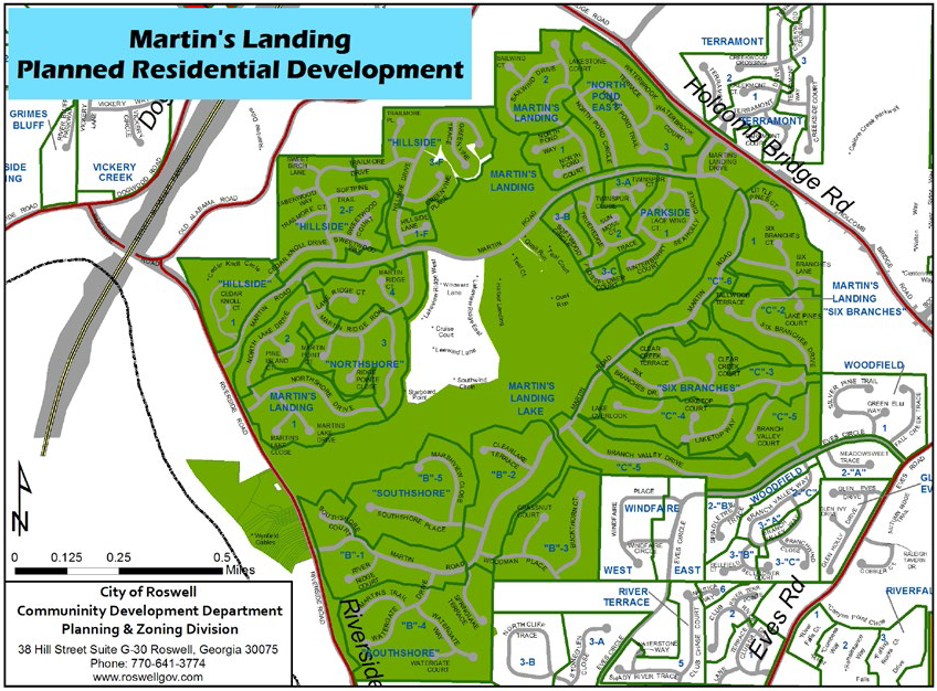
| Lot (min) | Setbacks (min) | ||||
|---|---|---|---|---|---|
| Phase Name | Width | Front | Side (street) | Side (interior) | Rear |
| Hillside unit one | 60' | 20' | 10' | 0' | 25' |
| Hillside F-1 | 75' | 35' | 20' | 7' | 25' |
| Hillside F-2 | 75' | 35' | 20' | 7' | 25' |
| Hillside F-3 | — | 20' or 35' | 20' | 7' | 25' |
| Avistele @ Martins Landing | — | 30' | 40' | 0' | 10' |
| North Pond East -1 | 85' | 35' | 20' | 7' | 30' |
| North Pond East - 2 | 85' | 35' | 20' | 20' | 30' |
| North Pond East - 3 | 85' | 35' | 20' | 7' | 30' |
| Northshore - 1 | 100' | 40' | 20' | 10' | 35" |
| Northshore - 2 | 100' | 40' | 20' | 10' | 35' |
| Northshore -3 | 100' | 40' | 20' | 10' | 35' |
| Northshore - 4 | 100' | 40' | 20' | 10' | 35' |
| Parkside - 1 | — | 35' | — | 7.5' | 30' |
| Parkside - 2 | — | 35' | — | 7.5' | 30' |
| Parkside - 3A | — | 35' | — | 7.5' | 30' |
| Parside - 3B | — | 35' | — | 7.5' | 30' |
| Parkside - 3C | — | 35' | — | 7.5' | 30' |
| Six Branches - 1 | 100' | 40' | 20' | 10' | 35' |
| Six Branches - 2 | 100' | 40' | 20' | 10' | 35' |
| Six Branches - 3 | 100' | 40' | 20' | 10' | 35' |
| Six Branches - 4 | 100' | 40' | 20' | 10' | 35' |
| Six Branches - 5 | 100' | 40' | 20' | 10' | 35' |
| Six Branches - 6 | 100' | 40' | 20' | 10' | 35' |
| Southshore B - 1 | 120' | 40' | 30' | 15' | 35' |
| Southshore B-2 | 120' | 40' | 30' | 15' | 35' |
| Southshore B-3 | 120' | 40' | 30' | 15' | 35' |
| Southshore B-4 | 120' | 40' | 30' | 15' | 35' |
| Southshore B-5 | 120' | 40' | 30' | 15' | 35' |
| Lakeview Patio Homes | — | 20' | 0' | — | 20' |
3.5.7. - Horseshoe Bend
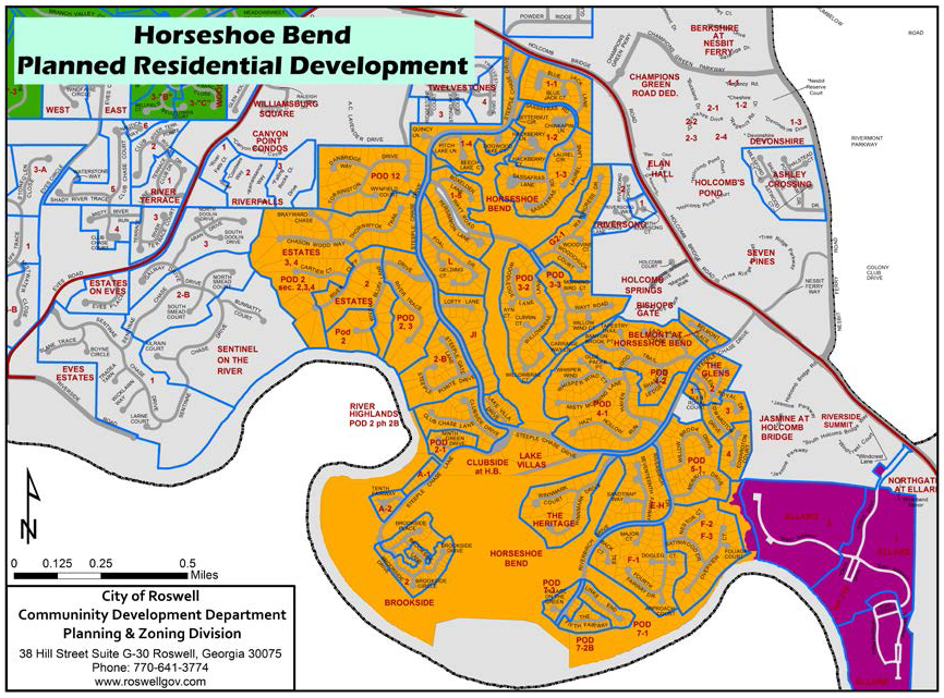
| Lot (min) | Setbacks (min) | ||||
|---|---|---|---|---|---|
| Phase Name | Width | Front | Side (street) | Side (interior) | Rear |
| Unit one - phase one | — | 20' | 30' | 10' | 35' |
| Unit one - phase two | — | 35' | 30' | 10' | 35' |
| Unit one - phase three | — | 35' | 30' | 10' | 35' |
| Unit one - phase four | — | 20' or 35' | 30' | 10' | 35' |
| Unit one - phase five | — | 30' | 30' | 10' | 35' |
| Area A - phase one | — | 35' | 30' | 10' | 35' |
| Area A - phase two | — | 35' | 30' | 10' | 35' |
| Brookside - phase one | — | 35' | 30' | 7.5' | 5' |
| Brookside - phase two | — | 40' | 30' | 7.5' | 5' |
| Clubside | 20' | 40' | 15' b/w bldg | 0' | 5' |
| Areas E and H | — | 40' | 30' | 10' | 35' |
| Pod 12 (The Estates) | 85' | 40' | 7.5' | 7' | 30'/35' |
| Estates Pod 2 sections 2,3,4 | 85' | 35' | 20' | 8' | 35' |
| Area F - phase one | 85' | 35' | 8' | 8' | 35' |
| Area F - phase two & three | 85' | 35' | 8' | 8' | 35' |
| Area G-2 phase one | — | 35' | 30' | 7.5' | 35' |
| Area G-2 phase two | — | 35' | 30' | 7.5' | 35' |
| Glens of Horseshoe Bend | 60' | 40' | 10' | 5' | 25'/20' |
| Heritage at Horseshoe Bend | None | 40' | 30' | 7.5' | 5' |
| Area J-1 | — | 40' | 30' | 7.5' | 35' |
| Area L | — | 40' | 30' | 7.5' | 35' |
| Lake Villas | — | 40' | 0' | 0' | 5' |
| Pod 2 | 85' | 40' | 20' | 20' | |
| Pod 2 - phase one | 45' | 40' | 0' | 0' | 5' |
| Pod 2 - phase three | 85' | 40' | 8' | 8' | 35' |
| Pod 3 - phase two | 85' | 40' | 7.5' | 7.5' | 35' |
| Pod 3- phase three | 85' | 40' | 8' | 7.5' | 35' |
| Pod 4 - phase one | 85' | 40' | 7.5' | 7.5' | 35' |
| Pod 4 -phase two | 85' | 20' | 7.5' | 7.5' | 35' |
| Pod 5 -phase one | 85' | 5' | 10' | 6' | 5' |
| Pod 7 - phase one | 35' | 5' | 0' | 0' | 5' |
| Pod 7 - phase three | 5' | 10' | 0' | 5' | |
| Pod 7 - phase two A | 85' | 5' | 0' | 0' | 5' |
| Pod 7 - phase two B | 45' | 5' | 0' | 0' | 5' |
| River Highlands @ HB | 20' | 5' | 15' b/w bldgs | 0' | 5' |
| Belmont @ HB | 60' | 20' | 15' | 5' | 20' |
| The Manors @ HB | 60' | 40' | 10' | 10' | 40' |
3.5.8. - Ellard
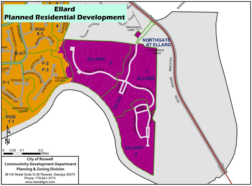
| Lot (min) | Setbacks (min) | ||||
|---|---|---|---|---|---|
| Phase Name | Width | Front | Side (street) | Side (interior) | Rear |
| Unit one | 8,000 SF lot - 60' | 10' | — | 10' b/w bldgs | 20' |
| Unit two | 9,000 SF lot - 70' | 10' | — | 10' b/w bldgs | 20' |
| Unit three | 10,000 SF lot - 80' | 10' | — | 10' b/w bldgs | 20' |
3.5.9. - Heatherton
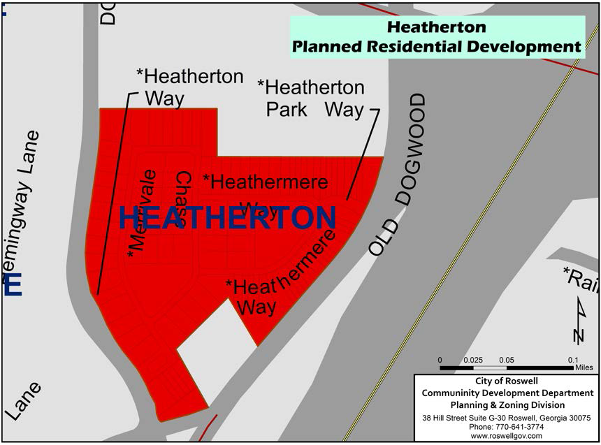
| Lot (min) | Setbacks (min) | ||||
|---|---|---|---|---|---|
| Phase Name | Width | Front | Side (street) | Side (interior) | Rear |
| SF | — | 20' | 0' | 0' | 20' |
| Duplex | — | 20' | 0' | 0' | 20' |
| TH | — | 20' | 0' | 0' | 20' |
3.5.10. - Willow Springs
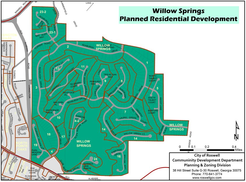
| Lot (min) | Setbacks (min) | ||||
|---|---|---|---|---|---|
| Phase Name | Width | Front | Side (street) | Side (interior) | Rear |
| Unit one | — | 50' | — | 10' | 35' |
| Unit two | — | 50' | — | 10' | 35' |
| Unit three | — | 50' | — | 10' | 35' |
| Unit four (Block A) | — | 50' | — | 10' | 35' |
| Unit four-two | — | 10' | — | 0' / 10' b/w bldgs | 10' |
| Unit five | — | 40' | 30' | 10' | 35' |
| Unit seven | — | 35' | 30' | 10' | 35' |
| Unit eight | — | 40' | 30' | 10' | 35' |
| Unit nine | — | 40' | 30' | 10' | 35' |
| Unit ten | — | 35' | 30' | 10' | 35' |
| Unit eleven | — | 40' | 30' | 10' | 30' |
| Unit thirteen | — | 20' | 20' | 6' | 30' |
| Unit fourteen | — | 40' | 30' | 10' | 30' |
| Unit sixteen | 100' | 40' | 30' | 10' | 30' |
| Unit seventeen | — | 40' | 30' | 10' | 30' |
| Unit eighteen | — | 50' | 30' | 10' | 35' |
| Unit nineteen | — | 40' | 30' | 10' | 30' |
| Unit twenty | 100' | 40' | 30' | 10' | 30' |
| Unit twenty-two A | — | 40' | 30' | 10' | 30' |
| Unit twenty-two B | — | 40' | 30' | 10' | 30' |
| Unit twenty-three phase one | — | 40' | 30' | 10' | 30' |
| Unit twenty-four | 70' | 10' | — | 0' / 10' b/w bldgs | 5' or 20' |
3.5.11. - Saddle Creek
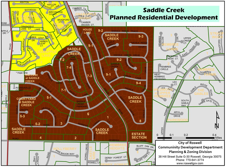
| Lot (min) | Setbacks (min) | ||||
|---|---|---|---|---|---|
| Phase Name | Width | Front | Side (street) | Side (interior) | Rear |
| Unit 1 | — | 50'/60' | 10' | 10' | 35' |
| Unit 1-7 | — | 50' | 25' | 10' | 35' |
| Unit 2 | — | 60' | 10' | 10' | 35' |
| Unit 2-5 | — | 50' | 10' | 10' | 35' |
| Unit 3 | — | 50' | 30' | 10' | 35' |
| Unit 3-5 | — | 50'/60' | 10' | 10' |
35'/120'
when adj. to Crabapple Rd |
| Unit 3-7 | — | 50' | 30' | 10' |
35'/100' when
adj. to Houze Rd |
| Unit 4 | — | 60' | 10' | 10' | 35' |
| Unit 4-7 | — | 35' | 25' | 10' | 35' |
| Unit 5-1 | — | 50' | 30' | 15' | 35' |
| Unit 5-2 | — | 50' | 10' | 10' | 35' |
| Unit 5-3 | — | 50' | 10' | 10' | 35' |
| Unit 6 | — | 50' | 30' | 10' | 35' |
| Unit 7-1 | — | 50' | 10' | 10' | 35' |
| Unit 7-2 | — | 50' | 10' | 10' | 35' |
| Unit 7-3 | — | 50' | 10' | 10' | 35' |
| Unit 7-4 | — | 35' | 10' | 10' | 35' |
| Unit 8 | — | 50' | 10' | 10' | 35'/100' when adj. to Houze Rd |
| Unit 9-1 | — | 40'/50' | 10' | 10' | 35'/100' when adj. to Houze Rd |
| Unit 9-2 | — | 50' | 10' | 10' | 35' |
| Unit 9-3 | — | 40'/50' | 10' | 10' | 35' |
| Unit 9-4 | — | 40'/50' | 10' | 10' | 35' |
(Ord. No. 2019-01-02, § 1, 1-14-2019)
3.5.12. - Crabapple
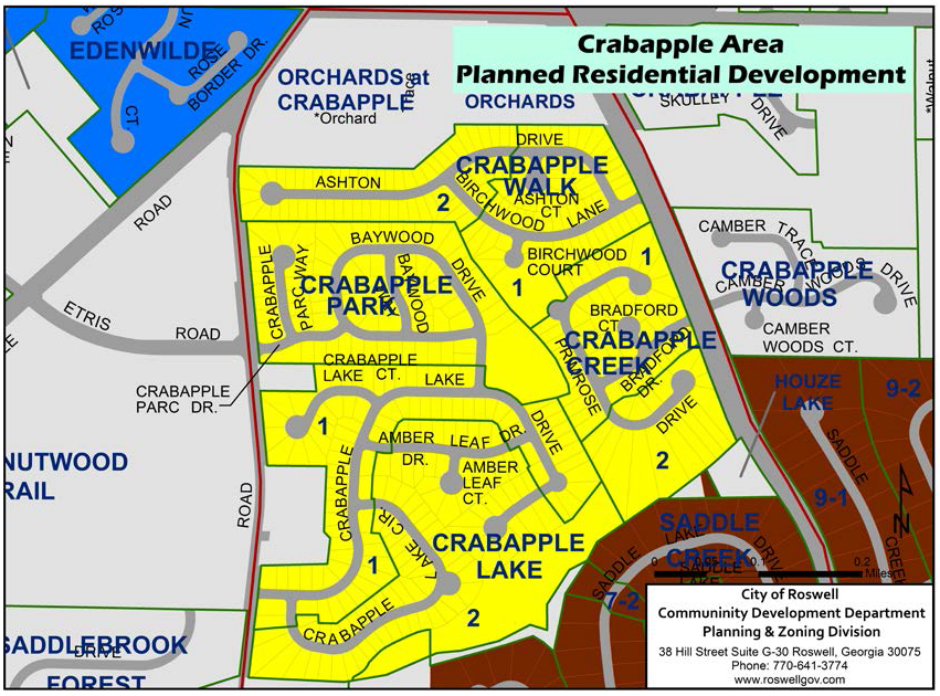
| Lot (min) | Setbacks (min) | ||||
|---|---|---|---|---|---|
| Phase Name | Width | Front | Side (street) | Side (interior) | Rear |
| Walk | — | 20' | 5' | 5' | 20' |
| Creek | — | 20' | 5' | 5' | 20' |
| Lake | — | 20' | 5' | 5' | 20' |
| Parc | — | 20' | 5' | 5' | 20' |
3.5.13. - Edenwilde
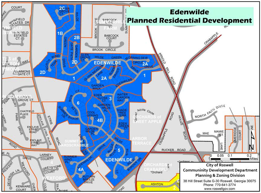
| Lot (min) | Setbacks (min) | ||||
|---|---|---|---|---|---|
| Phase Name | Width | Front | Side (street) | Side (interior) | Rear |
| Unit one | 70'/85' | 35' | 20' | 7' | 25'/50' |
| Unit one-B | 85' | 35' | 20' | 7' | 25'/50' |
| Unit two-A | 70' | 35' | 20' | 7' | 25' |
| Unit two-B | 85' | 35' | 20' | 7' | 25'/50' |
| Unit two-C | 85' | 35' | 20' | 7' | 25'/50' |
| Unit two-D | 85' | 35' | 20' | 7' | 25'/50' |
| Unit three | 70'/85' | 35' | 20' | 7' | 25'/50' |
| Unit four-A and five | 70'/85' | 35' | 20' | 7' | 25'/50' |
| Unit four-B | 70'/85' | 35' | 20' | 7' | 25'/50' |
| Unit six | 70'/85' | 35' | 20' | 7' | 25'/50' |
3.5.14. - Sentinel on the River
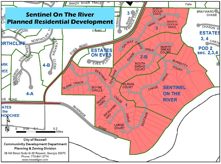
| Lot (min) | Setbacks (min) | ||||
|---|---|---|---|---|---|
| Phase Name | Width | Front | Side (street) | Side (interior) | Rear |
| All phases | — | 40' | 20' | 7 | 30' |
3.5.15. - Crabapple Pointe
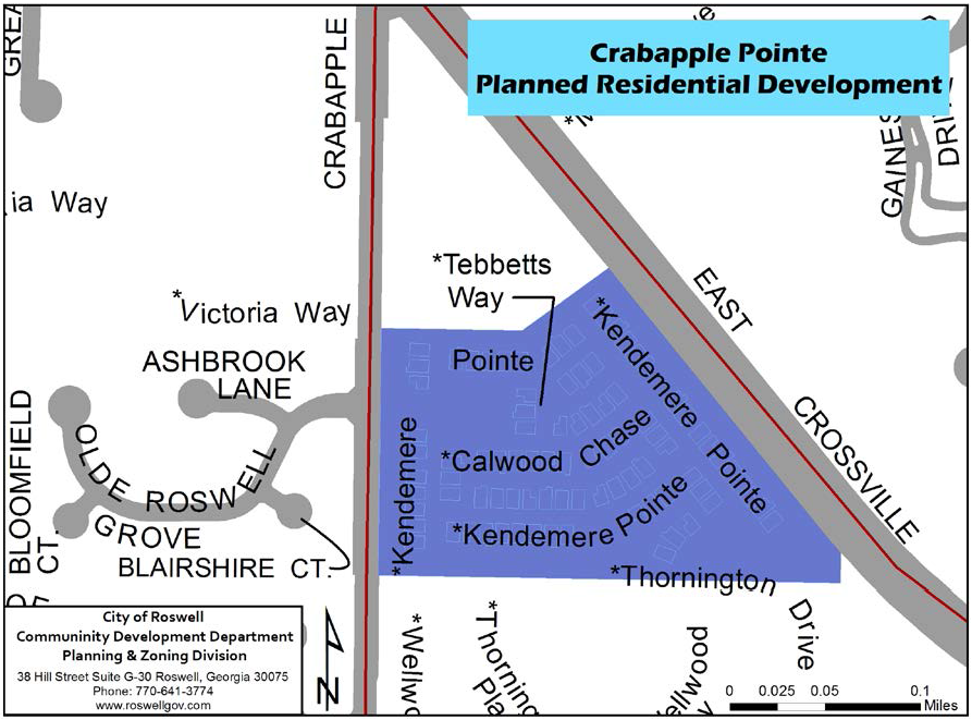
| Lot (min) | Setbacks (min) | ||||||
|---|---|---|---|---|---|---|---|
| Phase Name | Width | Front | Side (street) |
Side
(interior) | Bldg. Sep. (min) | Rear | |
| All | — | 0' | 0' | 0 | 10' | 30' |
Minimum heated floor
area of 2,200 SF |
3.5.16. - Alstead
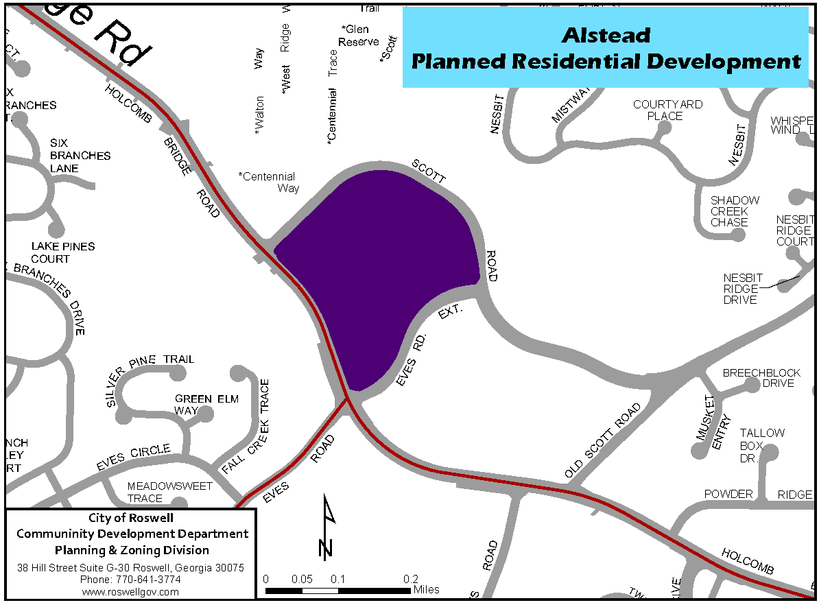
| Lot (min) | Setbacks (min) | Bldg. Sep. | ||||
|---|---|---|---|---|---|---|
| Phase Name | Width | Front | Side (street) | Side (interior) | Rear | (min) |
| Lots 50-59 | 35' | 0' | 0' | 0' | 0' | 10' |
| Lots 65-77 | 35' | 0' | 0' | 0' | 0' | 10' |
| Remaining Lots | 50' | 0' | 0' | 0' | 0' | 10' |
3.5.17. - Nesbit Lakes
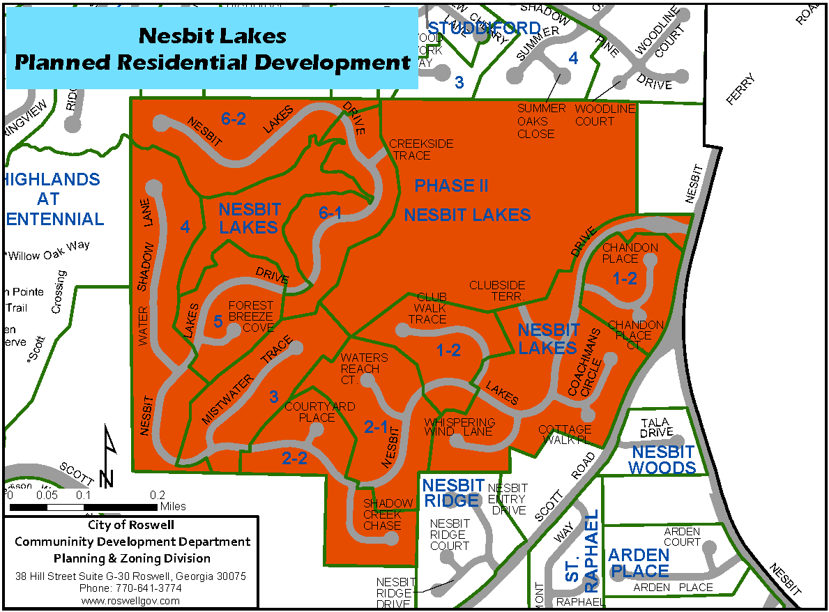
| Lot (min) | Setbacks (min) | ||||||
|---|---|---|---|---|---|---|---|
| Phase Name | Width at Bldg Line | Size (sq. ft.) | Front | Side | Side (corner) | Rear | Total Units |
| Unit 1-2 | 85' | 10,000 | 30' | 7.5' | 20' | 30' | 44 |
| Unit 2-1 | 80' | 10,000 | 25' | 7.5' | 20' | 30' | 21 |
| Unit 2-2 | 85' | 10,000 | 30' | 7.5' | 20' | 30' | 30 |
| Unit 3 | 85' | 10,000 | 30' | 7.5' | 20' | 30' | 24 |
| Unit 4 | 85' | 10,000 | 30' | 7.5' | 20' | 30' | 39 |
| Unit 5 | 85' | 10,000 | 30' | 7.5' | 20' | 30' | 22 |
| Unit 6-1 | 100' | 10,000 | 30' | 7.5 | 20' | 30' | 26 |
| Unit 6-2 | 85' | 10,000 | 30' | 7.5' | 20' | 30' | 27 |
| Phase II | 85' at ROW | 12,000 | 30' | 10' | 20' | 30' |
68 approved
on 3/19/15 |
3.5.18. - Roswell Green
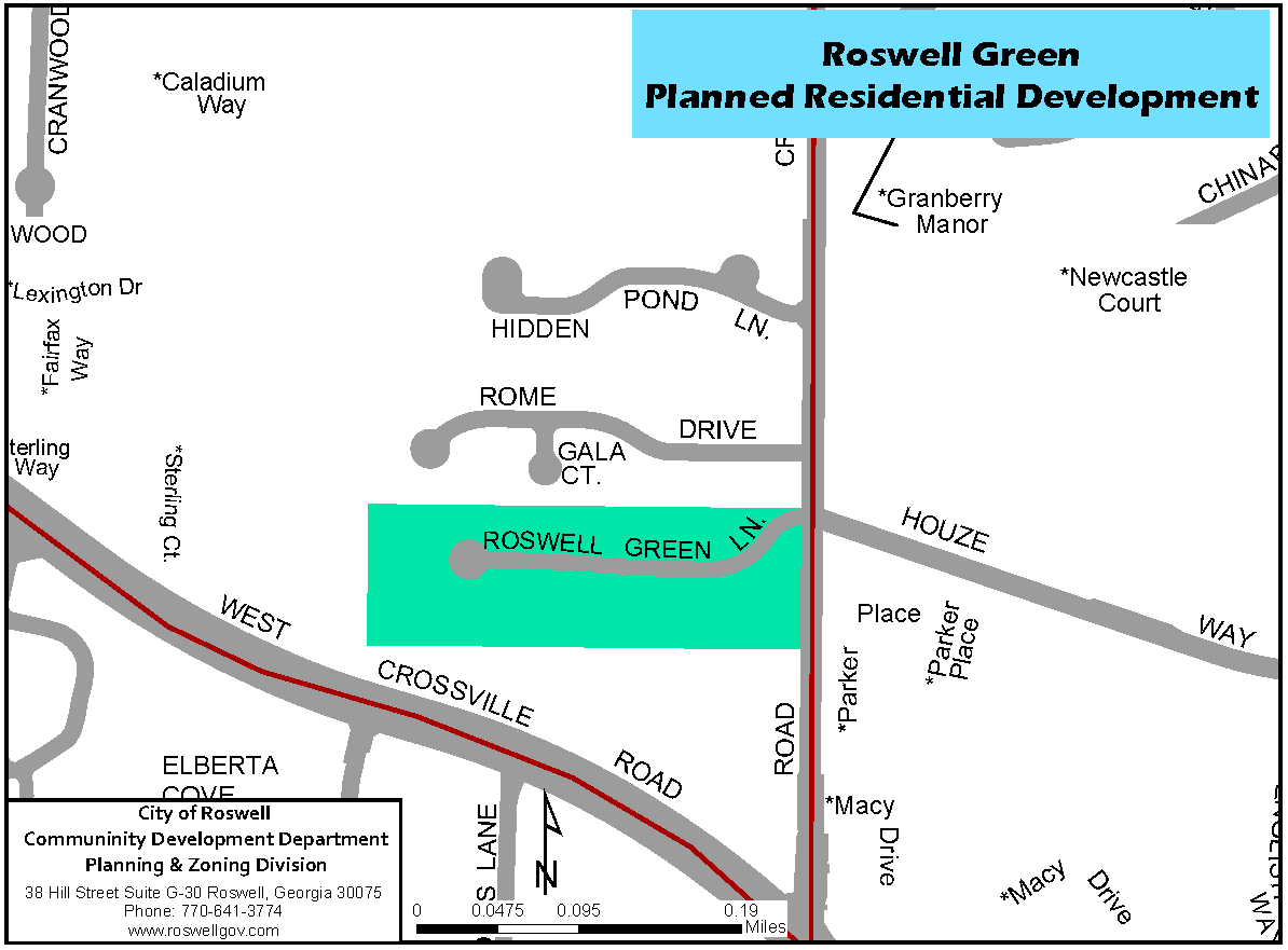
| Lot (min) | Setbacks (min) | Bldg. Sep. | ||||
|---|---|---|---|---|---|---|
| Width | Front | Side (street) | Side (interior) | Rear | (min) | |
| 35' | 30' | 30' | 10' | 25' | 10' | |