
Shreveport City Zoning Code
ARTICLE 4
- ZONING DISTRICT REGULATIONS
4.1 - GENERAL ZONING DISTRICT REGULATIONS
All development on a zoning lot is subject to the standards of this Article for the applicable zoning district and the standards of this Code, including, but not limited to:
A.
Article 7 for additional on-site development standards and requirements, such as exterior lighting, accessory structures and uses, and permitted encroachments.
B.
Article 8 for off-street parking and loading standards and requirements.
C.
Article 9 for sign standards.
D.
Article 10 for landscape and tree preservation standards and requirements.
E.
Article 11 for stormwater management standards and requirements.
F.
Article 16 for planned unit development or conditional zoning district approvals.
G.
Article 4 and Article 21 for Historic Preservation Overlay District (HPOD) standards, requirements, process and procedures.
(Ord. No. 6, 2019, § 35, 2-12-19; Ord. No. 149, 2024, § 3, 11-8-24)
4.2 - RESIDENTIAL DISTRICTS
A.
Purpose Statements
1.
R-A Rural Agricultural Zoning District
The intent of the R-A Rural Agricultural District is to permit single-family residences within agricultural areas. All residences within this district must be compatible with surrounding agricultural operations, and must maintain and preserve agricultural activities. Regulations are structured to protect the agricultural character of the district.
2.
R-E Residential Estate Zoning District
The purpose of the R-E Residential Estate District is to provide for large-lot, estate-type residential areas that create a low density environment that relates to the natural setting. Limited non-residential uses are allowed that are compatible with the low density, open character of the district.
3.
R-1-12 Single-Family Residential Zoning District
The R-1-12 Single-Family Residential Zoning District is intended to provide for a neighborhood environment of single-family detached dwellings located on larger lots of 12,000 square feet or more. Limited non-residential uses that are compatible with surrounding residential neighborhoods may be permitted.
4.
R-1-10 Single-Family Residential Zoning District
The R-1-10 Single-Family Residential Zoning District is intended to provide for a neighborhood environment of single-family detached dwellings located on 10,000 square foot lots that reflect the predominant pattern of single-family residential development in the Planning Area. Limited nonresidential uses that are compatible with surrounding residential neighborhoods may be permitted.
5.
R-1-7 Single-Family Residential Zoning District
The R-1-7 Single-Family Residential Zoning District is intended to provide for a neighborhood environment of single-family detached dwellings located on 7,000 square foot lots that reflect the predominant pattern of single-family residential development in the City of Shreveport. Limited non-residential uses that are compatible with surrounding residential neighborhoods may be permitted.
6.
R-1-5 Single-Family Residential Zoning District
The R-1-5 Single-Family Residential Zoning District is intended to provide for a neighborhood environment of single-family detached dwellings located on 5,000 square foot lots that have been established with a smaller lot size than the predominant pattern of single-family residential development. Limited non-residential uses that are compatible with surrounding residential neighborhoods may be permitted.
7.
R-UC Urban Core Residential Zoning District
The R-UC Urban Core Residential Zoning District is intended to provide for a denser neighborhood environment of single-family detached and attached, and two-family dwellings on lots with a small lot size to encourage redevelopment of neighborhoods located within or in close proximity to the urban core of the City of Shreveport. Limited non-residential uses that are compatible with surrounding residential neighborhoods may be permitted.
8.
R-HU Highland Urban Conservation Residential Zoning District
The R-HU Highland Urban Conservation Residential Zoning District is intended for two geographic areas of the Highland-Fairfield neighborhood that are deemed to have special and substantial public interest due to the large number of architecturally fine houses. Although individual structures may or may not be significant, the relationship between various buildings creates a whole that is greater than the sum of its parts. The regulations of the R-HU District aid in the preservation of both the architectural/historical and residential character of the area. The district permits traditional single-family and two-family dwellings with other limited uses allowed by special use subject to specific criteria.
9.
R-TH Townhouse Residential Zoning District
The R-TH Townhouse Residential Zoning District is intended to provide for a moderate density neighborhood environment of single-family detached and attached, two-family, and townhouse dwellings. This district may function as a transitional zone between predominantly single-family neighborhoods and adjacent higher density multi-family neighborhoods or non-residential areas. Limited non-residential uses that are compatible with surrounding residential neighborhoods may be permitted.
10.
R-2 Multi-Family Residential Zoning District
The R-2 Multi-Family Residential Zoning District is intended to provide for an environment of various dwelling types, including single-family detached and attached, two-family, townhouse, and low-rise multi-family dwellings. This district may function as a transitional zone between predominantly single-family neighborhoods and adjacent higher density multi-family neighborhoods or non-residential areas. Limited non-residential uses that are compatible with surrounding residential neighborhoods may be permitted.
11.
R-3 Multi-Family Residential Zoning District
The R-3 Multi-Family Residential Zoning District is intended to provide for an environment of various dwelling types, including single-family detached and attached, two-family, townhouse, and multi-family dwellings, including low-rise and mid-rise developments. Limited non-residential uses that are compatible with surrounding residential neighborhoods may be permitted.
12.
R-4 High-Rise Residential Zoning District
The R-4 High-Rise Residential Zoning District is intended to provide for a higher density environment of townhouse and multi-family dwellings, including low-rise, mid-rise, and high-rise developments. Limited non-residential uses that are compatible with surrounding residential neighborhoods may be permitted.
13.
R-MHS Residential Manufactured Home Subdivision Zoning District
The R-MHS Residential Manufactured Home Subdivision Zoning District is intended for a mix of manufactured homes approved by the Department of Housing and Urban Development and typical single-family dwellings. The district regulations are designed to protect the residential character of the area. Limited non-residential uses that are compatible with surrounding residential neighborhoods may be permitted.
14.
R-MHP Residential Manufactured Home Park Zoning District
The R-MHP District is intended for manufactured home parks, which are areas containing manufactured home sites arranged on a large tract, usually under single ownership, and designed to accommodate manufactured homes.
B.
Uses
Article 5 lists permitted and special principal uses and temporary uses for the residential districts.
C.
Dimensional Standards
1.
Table 4-1: Residential Districts Dimensional Standards establishes the dimensional standards for the residential districts. These regulations apply to all uses within each district unless a different standard is listed for a specific use.
2.
The R-MHP District standards are found in Section 4.2.D.
3.
The R-HU District has additional district specific standards in Section 4.2.E.
4.
Residential conversions of existing single-family dwellings to multi-unit dwellings are allowed in accordance with Section 4.2.F.
5.
Additional dimensional standards apply to residential lots located within the CLO Cross Lake Overlay Zoning District in Section 4.6.E.
TABLE 4-1: RESIDENTIAL DISTRICTS DIMENSIONAL STANDARDS
D.
R-MHP District Standards
Development in the R-MHP District is limited to manufactured home parks, which are subject to the following standards.
1.
Dimensional Standards
Table 4-2: R-MHP District Dimensional Standards establishes the dimensional standards for manufactured home parks in the R-MHP District. Standards are provided for the manufactured home park development overall and for individual manufactured home sites within the park.
TABLE 4-2: R-MHP DISTRICT DIMENSIONAL STANDARDS
2.
Design and Operation Standards
a.
Manufactured home parks must meet the following design standards:
i.
All manufactured home parks require site plan review.
ii.
The perimeter yard of a manufactured home park requires a buffer area of 15 feet at the furthest point in the required setback from the abutting lot line, and must contain the following:
(A)
A mix of shade and evergreen trees planted at an average of one tree for every 25 linear feet of yard width. These shade and evergreen trees may be clustered to allow for access points or to maximize the screening effect, conditioned on approval of the landscape plan.
(B)
Two ornamental trees may be substituted for one shade tree for up to 25% of required trees.
(C)
Shrubs must be planted at an interval of one shrub for every 3 feet of linear yard width, on center, and must be designed to present a continuous hedge or screen upon maturity.
(D)
The remainder of the buffer area must be planted with low groundcover, seed, or sod.
iii.
In addition to the required buffer area of the perimeter yard outlined above, the remainder of the setback must be landscaped as follows:
(A)
The landscape yard should be planted with low groundcover, seed, or sod.
(B)
A mix of shade and ornamental trees are required, planted at an average of one tree for every 750 square feet of yard area. These trees may be clustered to allow for access points or to maximize the screening effect, conditioned on approval of the landscape plan.
(C)
A minimum of 25% of trees provided must be ornamental in nature. Ornamental trees should constitute no more than 50% of required trees.
b.
Manufactured home sites within parks must meet the following design standards:
i.
The boundaries of each manufactured home site must be clearly marked.
ii.
There must be at least 20 feet between the sides of manufactured homes. Bay windows, porches, canopies or other projections are considered sides or ends of a mobile home when determining these requirements. Such projections, such as porches and canopies, must be constructed of fireproof material that meets the requirements of the Building Code.
iii.
Each manufactured home site must have a concrete slab or runway for the manufactured home to set on, and be of a size large enough to accommodate a manufactured home in such a fashion that the concrete will extend at least one inch around the walls of the manufactured home on all sides.
iv.
There must be a concrete slab along side of each manufactured home site of at least 12 feet by 30 feet to be used as a parking space for the occupants of the manufactured home. If a canopy is to be used over the area designated as car storage, it must be of fire-resistant material and is allowed only at the rear end of each carport area.
v.
All manufactured homes must be designed with skirting that is constructed of noncombustible or fire-resistant material that meets the requirements of the building code.
vi.
The front entry of a manufactured home should be a dominant feature of a manufactured home using features such as porches, raised steps and stoops with roof overhangs, or decorative railings.
E.
Additional Standards for the R-HU District
1.
Special Uses
Special uses in the R-HU District are subject to the following additional standards:
a.
In order to protect the architectural integrity of the residential areas, allows additional non-residential uses by the special use approval. In order to receive approval of a non-residential use, such approvals are limited to:
i.
Those areas that have experienced a significant decline in property standards; or
ii.
Those areas that are already significantly non-residential in nature.
b.
Where a conversion to a non-residential use or a multi-family use of an existing single-family or two-family residential is proposed, and because of their architectural and historical significance and use of surrounding properties, the architecturally or historically significant structure in question must be preserved without significant external modifications.
2.
Demolition Delay
Any application for a demolition permit and/or a Certificate of Demolition in the R-HU District involving a building, structure, site or object that is a contributing property, as defined by Article 21, or listed on the National Register of Historic Places, or listed on the Chapter 37 Local Register of Districts, Landmarks and Historic Properties, City of Shreveport, Louisiana shall be delayed 120 days in an attempt to ensure that alternative solutions, apart from demolition, have been explored.
If an R-HU property is within the General Historic Preservation Overlay District ("General-HPOD"), a Certificate of Demolition is required by the Executive Director of the Shreveport-Caddo MPC, or his/her designee, upon a recommendation (and in some cases decision) from the Shreveport Historic Preservation Commission. A demolition permit is also always required.
F.
Specific Standards for Residential Conversions
Residential conversions of single-family dwellings into multi-family dwellings within the residential districts are permitted for dwellings that meet the following standards. Residential conversions require site plan review approval. Construction drawings and plans that describe the proposed conversion in detail are required as part of the application. This does not apply to any conversions in the R-HU District, where such conversions are controlled by the district standards.
1.
The existing single-family dwelling must be a minimum of 1,750 square feet or more in gross floor area. This gross floor area calculation does not include any basement area.
2.
Upon conversion, the unit mix should meet the gross floor area as calculated by the unit types below:
a.
Efficiency Unit: 500 square feet.
b.
One Bedroom: 800 square feet.
c.
Two Bedroom: 1,000 square feet.
d.
Three or More Bedroom: 1,250 square feet.
3.
The dwelling must conform to the applicable dimensional standards for the district in which the building is located.
4.
No residential conversion may violate any occupancy regulations.
5.
One parking space must be provided for each additional dwelling unit.
6.
Following the conversion, the exterior of the dwelling must retain its existing residential character.
G.
Supplementary Yard Standards
1.
Front Yard Depth
In any residential district, including the R-A district, any building site lying between two adjacent building sites having dwellings erected on them shall have a front yard equal in depth at least to the average depth of the front yards of the two adjacent building sites; provided, however, that no front yard shall be less than 20 feet in depth, and no front yard shall be required to be more than 30% of the depth of the building site. This requirement is only applicable when either of the two adjacent buildings exceeds the required setback more than 125%.
2.
Additional Side Yard Width for Corner Lots
In any district, a corner lot abutting a lot facing toward the intersecting street shall have provided on the intersecting or side street side of the corner lot a side yard having a width equal at least to the depth of the required front yard for a structure on the lot to the rear of the corner lot;
a.
All principal and accessory structures shall be located behind this modified side yard setback line.
b.
This subsection shall not be applied to reduce the buildable width of the corner lot to less than 30 feet nor require a side yard of more than 20 feet.
c.
The provisions of this subsection shall apply if the intersecting street is undeveloped but intended for future improvement.
(Ord. No. 19, 2018, § 2, 3-13-18; Ord. No. 62, 2018, § 2, 8-14-18; Ord. No. 72, 2018, § 3, 8-28-18; Ord. No. 6, 2019, § 36, 2-12-19; Ord. No. 19, 2021, §§ 2, 3(Exh. B), 2-9-21; Ord. No. 137, 2021, § 2, 9-28-21)
4.3 - COMMERCIAL DISTRICTS
A.
Purpose Statements
1.
C-1 Neighborhood Commercial Zoning District
The C-1 Neighborhood Commercial District is intended to accommodate local non-residential uses that predominantly serve the needs of the nearby residential neighborhoods and are similar in character of the surrounding residential neighborhood. Residential dwelling units are allowed above the ground floor.
2.
C-2 Corridor Commercial Zoning District
The C-2 Corridor Commercial Zoning District is intended to accommodate the commercial corridors of the City of Shreveport. The C-2 District addresses primarily auto-oriented retail, both individual businesses and retail centers, with the intent of improving the pedestrian environment along the corridor. Mixed-use development is encouraged with residential dwelling units allowed above the ground floor.
3.
C-3 General Commercial Zoning District
The purpose of the C-3 General Commercial Zoning District is to accommodate regional commercial centers. The C-3 District provides for medium- and large-scale development that may generate a sizeable amount of traffic and typically requires significant off-street parking. Higher density residential uses are also allowed to facilitate mixed-use development where appropriate.
4.
C-4 Heavy Commercial Zoning District
The C-4 Heavy Commercial Zoning District is intended for areas of more intense commercial use, including uses related to motor vehicles and those that may require outdoor storage. Because of the impacts from more intensive commercial uses, the district regulations ensure that setbacks, buffering, and site development controls are in place to mitigate negative impacts on neighboring uses.
5.
C-UC Urban Corridor Commercial Zoning District
The C-UC Urban Corridor Commercial Zoning District is intended for corridor development that originally developed as mixed-use, traditional business districts. The C-UC District is intended to foster the continued development and redevelopment of these corridors in that established urban character and offer flexibility to developers and property owners in creating a mix of commercial, office, and residential spaces.
6.
C-UV Urban Village Commercial Zoning District
The C-UV Urban Village Commercial Zoning District is intended for large developments characterized by a mix of commercial uses and higher density residential, creating a coordinated mixed-use environment that is pedestrian-friendly and incorporates public space within the overall design.
B.
Uses
Article 5 lists permitted and special principal uses and temporary uses for the commercial districts.
C.
Dimensional Standards
1.
Table 4-3: Commercial Districts Dimensional Standards establishes the dimensional standards for the commercial districts. These regulations apply to all uses within each district unless a different standard is listed for a specific use. Section 4.3.D has additional design standards that apply to development within the districts.
2.
In the C-1 District commercial development is limited to the maximum gross floor area indicated in Table 4-3. Development may exceed this gross floor area if during site plan review the Executive Director finds that the development meets the following standards:
a.
The development maintains the privacy of adjacent residential lots through techniques such as decreased height, context sensitive landscape and screening, building massing design to mitigate noise, and increased setbacks from residential lots that mitigate noise and line of sight.
b.
Building design elements incorporate pedestrian-scale features such as awnings and canopies, sloped roofs, and residential-type design features.
c.
Site illumination is designed and installed to minimize adverse impact on adjacent residential lots.
d.
The site circulation system provides adequate and safe access to the site for any motor vehicles as well as alternate modes of transportation, including pedestrians and bicyclists, and minimizes potentially dangerous traffic movements.
3.
Certain standards within the C-UC District are applied as follows:
a.
Maximum lot area is only applicable to new lots created through subdivision or any other manner after the effective date of this Code.
b.
Any residential structures existing in the district as of the effective date of this Code that exceed the required build-to zones are deemed conforming with the limitation that the setback may not be further increased in excess of the required build-to zone. When the lot is redeveloped and the principal structure is torn down, new development must conform to the requirements of the district.
c.
A waiver of setback requirements within the C-UC District may be considered to increase the district's build-to-zone provided the increase is no greater than the front or side setbacks for existing structures on adjacent lots on the same street frontage. The waiver shall not, in the opinion of the Executive Director, have an adverse effect on the neighborhood or general welfare of the area.
TABLE 4-3: COMMERCIAL DISTRICTS DIMENSIONAL STANDARDS
D.
Commercial Design Standards
1.
The following design standards apply to new construction, substantial repair or rehabilitation meant to remedy damage or deterioration of the exterior façade of an existing structure, and additions to an existing structure. However, only those standards that relate to the specific repair, rehabilitation, or addition apply. These standards do not apply to interior remodeling. When residential dwellings are allowed, those are subject to the applicable use standards of Article 6 of this Ordinance. Table 4-4: Commercial Design Standards indicates the applicability of building design standards to the commercial districts. In the C-UV District, any commercial design standards that apply along a public right-of-way are also applicable along any roadways internal to the site. A "•" indicates that the standard is applicable in the district indicated. The absence of a "•" indicates that the standard is not applicable.
Click this link to download a PDF version of Table 4-4.
TABLE 4-4: COMMERCIAL DESIGN STANDARDS
FIGURE 4-1: COMMERCIAL DESIGN STANDARDS
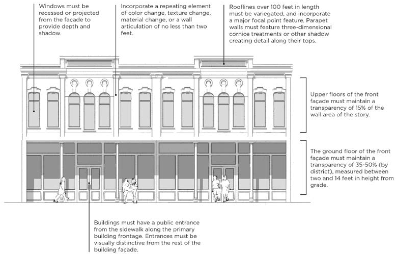
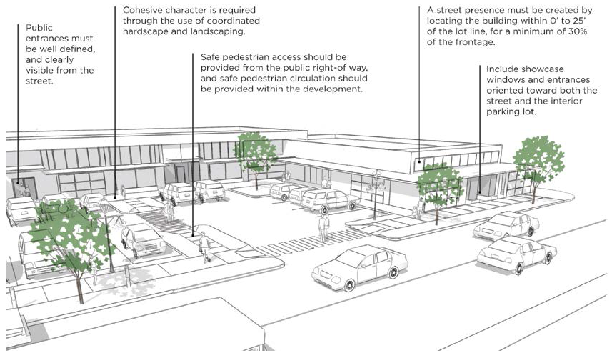
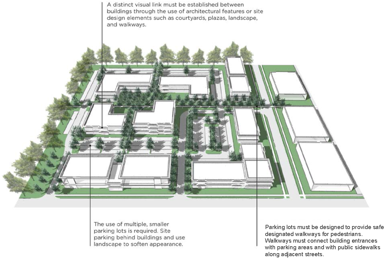
FIGURE 4-2: C-UV SITE DESIGN STANDARDS
2.
In order to meet the required percentage of open space required in the C-UV District, the following types of open space are permitted and must be indicated on plan submittals.
a.
Greens. A green where open space is available for unstructured recreation. Its landscaping consists of grassy areas and trees.
b.
Parks. A park must be a minimum of 5,000 square feet in size.
c.
Plaza/Square. A plaza or square that is improved by landscaping and hardscaping, and surrounded by buildings or streets along at least 50% of its perimeter.
d.
Drainage Control Facilities. These include detention or retention ponds, which are usable by the public for recreational purposes.
3.
The following building materials are limited on any facade facing a public right-of-way, excluding alleys, or any facade that abuts a lot in residential use. However, such materials may be used as decorative or detail elements for up to 40% of the facade, or as part of the exterior construction that is not used as a surface finish material.
a.
Plain concrete block
b.
Corrugated metal
c.
Aluminum, steel, or other metal sidings
d.
Exposed aggregate (rough finish) concrete wall panels
e.
T-111 composite plywood siding
f.
Plastic
g.
Vinyl
(Ord. No. 76, 2017, § 8, 9-12-17; Ord. No. 62, 2018, §§ 3, 4, 8-14-18; Ord. No. 6, 2019, § 3(Exh. A.1), 2-12-19; Ord. No. 191, 2019, § 2, 1-14-20; Ord. No. 2, 2020, § 2(Exh. B), 1-28-20; Ord. No. 114, 2020, § 3, 9-8-20; Ord. No. 95, 2021, § 1, 7-13-21; Ord. No. 182, 2023, § 1, 1-9-24)
4.4 - D-1 DOWNTOWN ZONING DISTRICT
A.
Purpose Statement
The D-1 Downtown Zoning District is intended for the City of Shreveport's Downtown. In order to address the different character areas that make up downtown, the D-1 District is divided into a series of sub-districts that tailor dimensional standards and design standards to recognize and achieve the different physical characteristics of Downtown. These sub-districts are:
1.
D-1-CBD Downtown Core Sub-District
The D-1-CBD Downtown Core Sub-District is intended to establish standards for the design of structures located within the core of Downtown. The standards recognize that this sub-district is to be the most intensely developed portion of the Downtown.
2.
D-1-E Downtown Entertainment Sub-District
The D-1-E Downtown Entertainment Sub-District is intended for large-scale entertainment and related uses clustered within the Downtown, such as casinos and the convention center.
3.
D-1-CMU Downtown Commercial Mixed-Use Sub-District
The D-1-CMU Downtown Commercial Mixed-Use Sub-District is intended for smaller floor plate office, retail, personal service, and institutional that support the vitality of the Downtown. Residential uses are also permitted to foster a mixed-use environment.
4.
D-1-RMU Downtown Residential Mixed-Use Sub-District
The D-1-RMU Downtown Residential Mixed-Use Sub-District is intended for a downtown neighborhood environment by allowing a mix of housing types and supporting commercial uses. The D-1-RMU Sub-District can also function as a transition between the more intensive development of the Downtown and the more modest-scale development found in adjacent neighborhoods.
5.
D-1-AC Downtown Arts and Culture Sub-District
The D-1-AC Downtown Arts and Culture Sub-District is intended to facilitate sustainable development and use as a creative cultural community. The D-1-AC Sub-District is intended to be a pedestrian-friendly, mid-rise, mixed-use district, including residential, retail, and adaptive reuse of historic buildings, and new construction anchored by arts, culture, and entertainment institutions and facilities, as well as signature open space
6.
D-1-HC Downtown Heavy Commercial Sub-District
The D-1-HC Downtown Heavy Commercial Sub-District is intended for existing areas of heavy commercial uses, such as select light manufacturing and warehouse uses and auto-oriented uses, that are generally located on the edge of Downtown. The standards of the D-1-HC both accommodate existing uses and facilitate the reuse of existing structures.
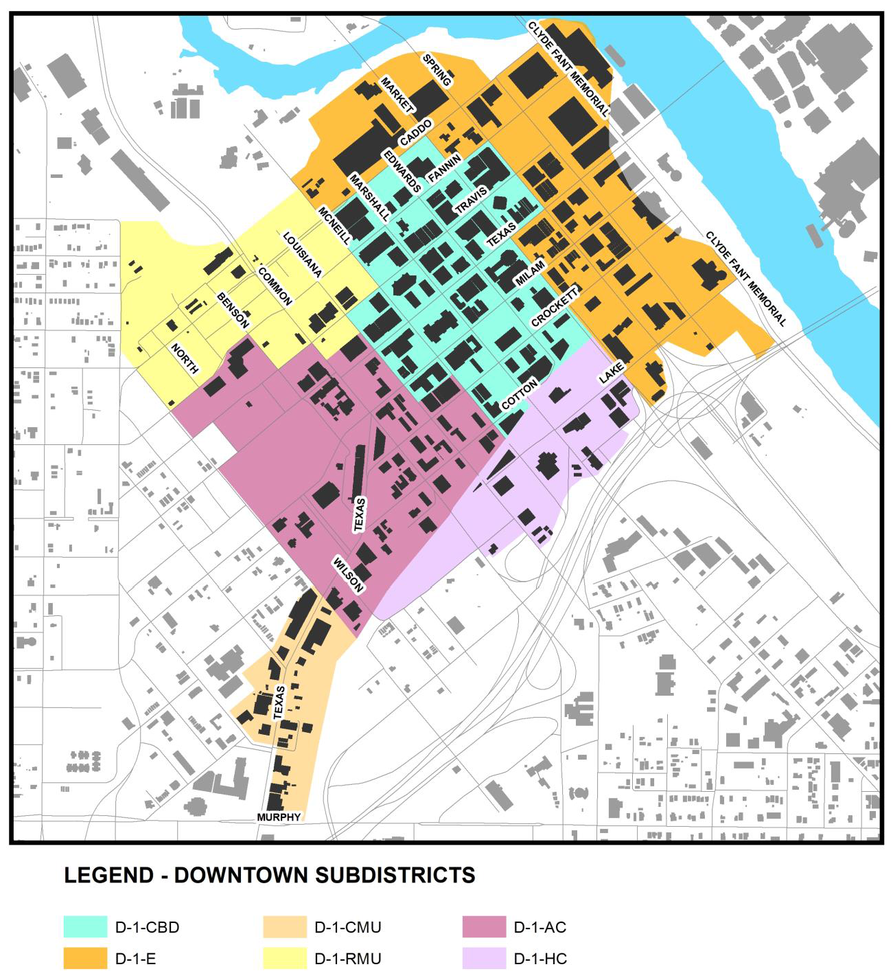
FIGURE 4-3: DOWNTOWN SUBDISTRICTS
B.
Uses
Article 5 lists permitted and special principal uses and temporary uses for the downtown sub-districts.
C.
Dimensional Standards
1.
Table 4-5: Downtown Sub-Districts Dimensional Standards establishes the dimensional standards for the downtown sub-districts. These regulations apply to all uses within each district unless a different standard is listed for a specific use. Section 4.4.D has additional design standards that apply to development within the districts.
2.
Maximum building heights in the Downtown Sub-Districts may be limited by additional regulations within Chapter 18 (Aviation) of the Shreveport Code of Ordinances.
TABLE 4-5: DOWNTOWN SUB-DISTRICTS DIMENSIONAL STANDARDS
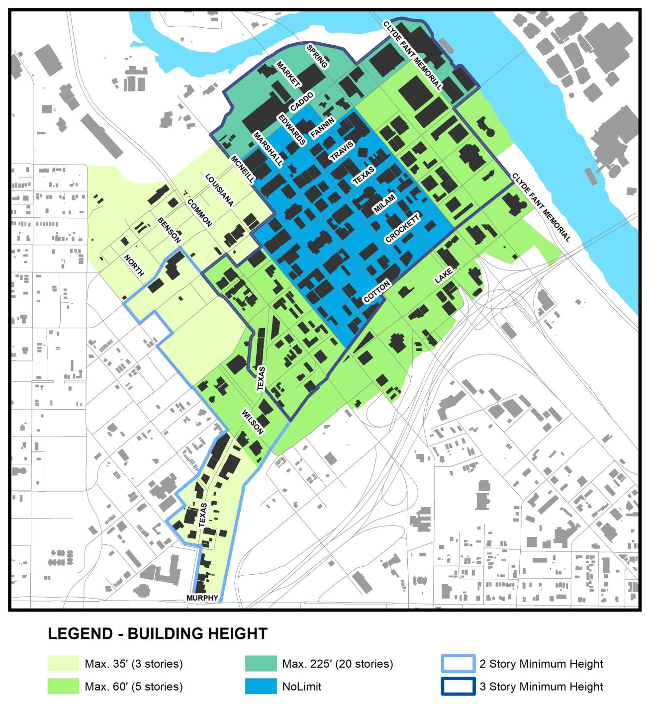
FIGURE 4-4: DOWNTOWN DISTRICT HEIGHT MAP
D.
Downtown Design Standards
1.
The following design standards apply to new construction, substantial repair or rehabilitation meant to remedy damage or deterioration of the exterior façade of an existing structure, and additions to an existing structure. However, only those standards that relate to the specific repair, rehabilitation, or addition apply. These standards do not apply to interior remodeling. Table 4-6: Downtown Design Standards indicates the applicability of building design standards to the Downtown Sub-Districts. A "•" indicates that the standard is applicable in the district indicated. The absence of a "•" indicates that the standard is not applicable.
Click this link to download a PDF version of Table 4-6.
TABLE 4-6: DOWNTOWN DESIGN STANDARDS
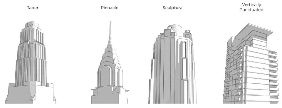
FIGURE 4-5: DOWNTOWN DISTRICT BUILDING DESIGN
2.
The following building materials are limited on any façade facing a public right-of-way, excluding alleys, or any façade that abuts a lot in residential use. However, such materials may be used as decorative or detail elements for up to 35% of the facade, or as part of the exterior construction that is not used as a surface finish material.
a.
Plain concrete block
b.
Corrugated metal
c.
Aluminum, steel or other metal sidings
d.
Exposed aggregate (rough finish) concrete wall panels
e.
T-111 composite plywood siding
f.
Plastic
g.
Vinyl
(Ord. No. 6, 2019, § 4(Exh. B.1), 2-12-19; Ord. No. 191, 2019, § 3(Exhs. B, C), 1-14-20)
4.5 - INDUSTRIAL DISTRICTS
A.
Purpose Statements
1.
OR Office Research Zoning District
The OR Office Research Zoning District is intended to accommodate larger office structures outside the downtown, office parks, and research and development facilities, which may include limited light industrial uses with no outside impacts.
2.
I-MU Industrial Mixed-Use Zoning District
The purpose of the I-MU Industrial Mixed-Use Zoning District is to provide for a mix of light industrial uses, compatible commercial uses, such as recreation, entertainment, and retail establishments, and higher density residential.
3.
I-1 Light Industrial Zoning District
The purpose of the I-1 Light Industrial Zoning District is to provide for a wide variety of light manufacturing, fabricating, processing, wholesale distributing, and warehousing uses. Light industrial uses are enclosed, low-intensity, non-nuisance light fabrication and assembly-type manufacturing, as well as office and research and development facilities with little to no outside impacts.
4.
I-2 Heavy Industrial Zoning District
The purpose of the I-2 Heavy Industrial Zoning District is to provide for a wide variety of general manufacturing, fabricating, processing, wholesale distributing and warehousing uses. Commercial uses and open storage of materials are allowed. The industrial uses include fabrication, warehousing and assembly-type manufacturing, as well as office and research and development facilities, which may result in some moderate external effects such as smoke, noise, glare or vibration, and typically include outdoor storage and related outdoor activities.
B.
Uses
Article 5 lists permitted and special principal uses and temporary uses for the industrial districts.
C.
Dimensional Standards
Table 4-7: Industrial Districts Dimensional Standards establishes the dimensional standards for the industrial districts. These regulations apply to all uses within each district unless a different standard is listed for a specific use. Section 4.5.D has additional design standards that apply to development within the districts.
TABLE 4-7: INDUSTRIAL DISTRICTS DIMENSIONAL STANDARDS
D.
Industrial Design Standards
1.
The following design standards apply to new construction, substantial repair or rehabilitation meant to remedy damage or deterioration of the exterior façade of an existing structure, and additions to an existing structure. However, only those standards that relate to the specific repair, rehabilitation, or addition apply. These standards do not apply to interior remodeling. Table 4-8: Industrial Building Design Standards indicates the applicability of building design standards to the industrial districts. A "•" indicates that the standard is applicable in the district indicated. The absence of a "•" indicates that the standard is not applicable.
Click this link to download a PDF version of Table 4-8.
TABLE 4-8: INDUSTRIAL BUILDING DESIGN STANDARDS
2.
In the OR, I-MU, and I-1 Districts, the following building materials are limited on any facade facing a public right-of-way, excluding alleys, or any facade that abuts a lot in residential district. However, such materials may be used as decorative or detail elements for up to 40% of the facade, or as part of the exterior construction that is not used as a surface finish material.
a.
Plain concrete block (only prohibited in the OR District)
b.
Corrugated metal
c.
Aluminum, steel or other metal sidings
d.
Exposed aggregate (rough finish) concrete wall panels
e.
T-111 composite plywood siding
f.
Plastic
g.
Vinyl
FIGURE 4-6: INDUSTRIAL DISTRICT DESIGN STANDARDS
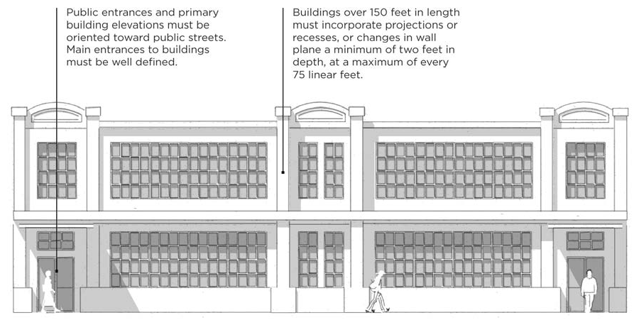
FIGURE 4-7: INDUSTRIAL DISTRICT SITE DESIGN STANDARDS
(Ord. No. 62, 2018, §§ 5, 6, 8-14-18; Ord. No. 2, 2020, § 3(Exh. C), 1-28-20; Ord. No. 137, 2021, § 3, 9-28-21)
4.6 - SPECIAL PURPOSE DISTRICTS
A.
IC Institutional Campus Zoning District
1.
Purpose Statement
The IC Institutional Campus Zoning District is intended to accommodate large institutional uses, such as universities, select vocational educational facilities, and healthcare institutions, to allow for their expansion in a planned manner while protecting the surrounding neighborhoods.
2.
Uses
Article 5 lists permitted and special principal uses and temporary uses for the IC Institutional Campus Zoning District.
3.
Dimensional Standards
Table 4-9: IC District Dimensional Standards establishes the dimensional standards for the IC District. These regulations apply to all uses within each district unless a different standard is listed for a specific use.
TABLE 4-9: IC DISTRICT DIMENSIONAL STANDARDS
4.
Institutional Master Plan
An institutional campus may apply for approval of an Institutional Master Plan, which may deviate from the dimensional standards of Table 4-9. Once an Institutional Master Plan is submitted and approved, the development proceeds in accordance with the plan rather than the base district regulations. Institutional Master Plan approval must proceed in accordance with the standards of this section.
a.
An Institutional Master Plan may be applied only to those properties owned by or under unified control of the applicant.
b.
The Institutional Master Plan must address the general site layout of the entire area and include the following:
i.
Concept plans for development of the entire district including the boundaries of the proposed district and the ownership of the land therein.
ii.
The location, square footage and building heights of all existing structures and a general range of the location, square footage, and building heights of all proposed structures and uses intended.
iii.
Landscape plan that shows the general location of all open space and any buffering or screening along the perimeter of the district.
iv.
Sign plan that shows the general location of, including on-site identification and directional signs, and the proposed off-site directional sign plan.
v.
Internal traffic circulation plans, including traffic ingress and egress locations, pedestrian circulation, bicycle circulation, and public transit access.
vi.
The location and capacity of all off-street parking and loading spaces.
vii.
Estimates of traffic load impact on surrounding public street system.
c.
An IC District controlled by an Institutional Master Plan is established in accordance with the following procedures.
i.
All Institutional Master Plans must be filed with the Executive Director. Once it is determined that the application is complete, the Executive Director will schedule the application for consideration by the Metropolitan Planning Commission.
ii.
After receipt of a complete application, the Metropolitan Planning Commission will consider the Institutional Master Plan at a public meeting. The Metropolitan Planning Commission will forward its recommendation to the City Council.
iii.
The City Council will approve, approve with conditions, or deny an Institutional Master Plan proposed for properties within the boundaries of the City of Shreveport.
iv.
The City Council must act on the application within 60 days of receipt of the Metropolitan Planning Commission recommendation. The City Council must take action in the form of approval, approval with conditions, or denial.
v.
If the City Council does not act upon the application within 60 days of receipt of the Metropolitan Planning Commission recommendation, the application is deemed denied unless the City Council grants additional consideration time.
d.
The following development actions are considered consistent with an approved Institutional Master Plan, even if not specifically shown on that approved Institutional Master Plan:
i.
Construction of new structures of 2,000 square feet of gross floor area or less that are adjunct to and support an existing use on campus.
ii.
Additions to existing structures of less than 25% of the existing gross floor area or 10,000 square feet in gross floor area, whichever is less.
iii.
A change of use to any use permitted within the district.
iv.
New parking facilities of 10 or fewer parking spaces.
v.
Creation or expansion of any bicycle parking facilities.
vi.
Creation or expansion of open space, and alternate landscape designs and stormwater management techniques.
vii.
Façade renovation to an existing structure.
viii.
Interior renovations to an existing structure.
B.
NA Natural Areas Zoning District
1.
Purpose Statement
The NA Natural Areas Zoning District is intended to protect and preserve existing natural areas such as forest areas, wetlands, and waterways. Natural areas are maintained in a predominantly undeveloped state, though very limited development may be allowed for passive recreation and educational purposes, but must be compatible with and cause little impact to these areas.
2.
Uses
Article 5 lists permitted and special principal uses and temporary uses for the NA Natural Areas Zoning District.
3.
Dimensional Standards
Table 4-10: NA District Dimensional Standards establishes the dimensional standards for the NA District. These regulations apply to all uses within each district unless a different standard is listed for a specific use.
TABLE 4-10: NA DISTRICT DIMENSIONAL STANDARDS
4.
Design Standards
a.
Trails and related public amenities for passive recreation are encouraged but must not create any negative impacts on environmentally sensitive areas.
b.
Native vegetation, such as grasses, shrubs, and trees, may only be disturbed to control noxious or invasive vegetation or to remove dead, dying, or diseased vegetation.
c.
Building materials used for structures or public amenities must use muted, natural colors. Bright colors and reflective material are prohibited.
C.
OS Open Space Zoning District
1.
Purpose Statement
The OS Open Space Zoning District is intended to provide and protect open space and public recreational facilities, both outdoor and indoor, located within the City of Shreveport. Larger regional open spaces/parks may include both active and passive recreation areas and certain ancillary commercial activities, such as cultural facilities, performance venues, and restaurants.
2.
Uses
Article 5 lists permitted and special principal uses and temporary uses for the OS Open Space Zoning District.
3.
Dimensional Standards
Table 4-11: OS District Dimensional Standards establishes the dimensional standards for the OS District. These regulations apply to all uses within each district unless a different standard is listed for a specific use.
TABLE 4-11: OS DISTRICT DIMENSIONAL STANDARDS
D.
Redevelopment Mixed Use Village District
1.
Purpose Statement
The intent of the Redevelopment Mixed Use Village District is to permit a variety of residential uses and limited non-residential uses within the same development creating a coordinated mixed use environment. It is intended that the development will blend residential commercial, cultural institutional or entertainment uses into one space where those functions are to some degree physically and functionally integrated so that a pedestrian friendly environment is created. Although not specifically regulated under this Code, detached and semi-detached dwelling units under the size of 500 square feet per unit (commonly referred to as tiny houses) are taken into consideration in the development of this district.
2.
Uses
The following uses are permitted for any use or group of uses that are developed either separately or as a unit with certain site improvements shared in common within the Residential Mixed Use Village (RMUV) District.
a.
Residential Uses
i.
Residential uses may be in the form of detached or attached units and may be in a single structure or within a multi-use building. Residential units may be developed within an area within the development boundaries or may be included with a building with non-residential uses.
ii.
Permitted Uses
1.
Dwelling above the ground floor
2.
Dwelling—Age restricted housing
3.
Dwelling—Single-family detached
4.
Dwelling—Single-family attached
5.
Dwelling—Two-family
iii.
Special Uses
1.
Manufactured homes
2.
Recreational vehicles
b.
Non-Residential Uses
i.
Non-residential uses may be developed as a singular non-residential buildings or a mix of residential and non-residential uses.
ii.
Non-residential buildings (not including community center) shall not exceed a total of 10,000 gross square feet in a single detached building.
iii.
Non-residential uses (not including community center) shall not exceed 50% of the total gross building area of the entire development.
iv.
Permitted uses
1.
Agriculture
2.
Art gallery
3.
Art studio
4.
Bus transfer station
5.
Community center
6.
Food truck park
7.
Medical or dental office
8.
Office
9.
Personal service establishment
10.
Place of worship
11.
Restaurant
12.
Retail goods establishment
13.
Self-storage facility climate controlled
14.
Social services
15.
Soup kitchen accessory
16.
Shelter housing
17.
Specialty food service
v.
Special Uses
1.
Animal care facility
2.
Body modification establishment
3.
Food truck park major
4.
Industrial artisan
5.
Industrial light (limited to indoor fabrication and assembly only)
6.
Reception facility
7.
Vehicle repair/service minor
vi.
Temporary Uses
1.
Farmers market
2.
Temporary outdoor entertainment
3.
Temporary outdoor sales
3.
Planned Building Groups
a.
Planned building groups are permitted by right in this district. Planned building groups allow separate buildings and uses to be constructed on a single lot. This concept will allow multiple one-family, duplexes, and non-residential structures to be placed within one property boundary without the need to subdivide each building site. For the purposed of this Code, the use descriptions of residential dwelling types including single family dwellings will still be valid although they are not required to be placed on separate lots. The placement of all improvements within the site will be subject to site plan review to insure that the overall development is in compliance with all required standards and best practices.
4.
Dimensional Standards
a.
Minimum Lot Area
For developments where all improvements are on a single lot (planned building groups), the minimum lot area shall be 25,000 square feet.
b.
Minimum Lot Area for Individual Lots
The minimum lot area shall be as follows:
i.
Single-family detached dwellings over 500 square feet—4,000 square feet
ii.
Single-family detached dwellings 500 square feet or less—1,200 square feet
iii.
Single-family attached (duplex) and two-family dwellings over 500 square feet each—5,000 square feet
iv.
Single-family attached (duplex) and two-family dwellings 500 square feet or less each—2,500 square feet
v.
Non-residential—None
vi.
Mixed residential and non-residential—None
c.
Minimum Lot Width
i.
Single-family detached dwellings over 500 square feet—50 feet
ii.
Single-family detached dwellings 500 square feet or less—20 feet
iii.
Single-family attached and two-family dwellings over 500 square feet each—60 feet
iv.
Single-family attached and two-family dwellings 500 square feet or less each—40 feet
v.
Non-residential and residential planned building groups—75 feet
d.
Building Height
i.
Single-family detached/attached and two-family dwellings—35 feet
ii.
Non-residential and mixed residential and non-residential structures—40 feet
e.
Maximum Building Coverage
i.
Residential uses—45 percent
ii.
Maximum impervious surface—70 percent
f.
Building Setbacks
i.
Front yard building setback—20 feet
ii.
Single-story interior side yard setback—Five feet
iii.
Multi-story interior side yard setback—10 feet
iv.
Minimum reverse and side corner setback—10 feet
v.
Minimum rear yard setback—15 feet
g.
Zero Lot Line
i.
Single-family residential lots may be allowed to be placed on the interior side property line without a setback, provided that the opposite side yard setback is at least double the setback distance required by Code. If employed as a part of the development, care should be taken to insure that pattern remains consistent so that minimum required building separation is maintained. Zero lot line setbacks will not be allowed at the lot lines on the perimeter of the development.
h.
Minimum Building Separation
i.
The minimum spacing between buildings shall be 10 feet unless otherwise required to be a greater dimension by fire and building codes.
5.
Required Landscaped Buffer
a.
When abutting any residential district a minimum 10-foot wide landscaped buffer will be required in accordance with Section 10.9.A. The Executive Director may consider existing vegetation that will remain undisturbed as alternative compliance to this requirement.
6.
Design Standards
a.
Non-Residential Structures
i.
Building Materials
1.
The following building materials are limited on any facade facing a public right-of-way, excluding alleys. However, such materials may be used as decorative or detail elements for up to 40% of the facade, or as part of the exterior construction that is not used as a surface finish material.
a.
Plain concrete block
b.
Corrugated metal
c.
Aluminum, steel, or other metal sidings
d.
Exposed aggregate (rough finish) concrete wall panels
e.
T-111 composite plywood siding
f.
Plastic
g.
Vinyl
ii.
Façade Design
1.
Building facades that abut a public right-of-way, excluding alleys, must not contain blank wall areas that exceed 35 linear feet, measured parallel to the street.
2.
Building facades in excess of 100 feet that abut a public right-of-way, excluding alleys, must include a repeating pattern with no less than two of the following elements: color change, texture change, material module change, or a wall articulation change of no less than two feet in depth, such as a reveal, pilaster, or projecting rib. All elements must repeat at intervals of no more than 40 feet.
iii.
Fenestration Design
1.
Any façade facing a public right-of-way, excluding alleys shall have a minimum fenestration requirement of 20 percent.
b.
Residential Structures
i.
Shall comply with Article 6.1-P.
c.
Administrative Relief from Design Standards
i.
As a part of site plan review, the Executive Director may grant relief from any or all of the above standards as a part of an assessment of compatibility with surrounding properties.
7.
Vehicular Parking
a.
Minimum Required Parking
i.
Residential uses—One parking spaces per dwelling unit
ii.
Non-residential uses—One parking space for every 500 square feet
b.
Parking Maximums
i.
There are no parking maximum limits for this district.
c.
Parking Exemptions
i.
Parking is not required for the following uses:
1.
Bus transfer station
2.
Community center
3.
Community garden
4.
Industrial artisan
5.
Industrial light
8.
Bicycle Parking
a.
Short Term Parking
i.
Non-residential uses—One bicycle parking space shall be required for every four required parking spaces.
ii.
Residential uses—0.2 bicycle parking space per dwelling unit.
b.
Long Term Parking
i.
Residential uses—0.4 parking spaces per dwelling unit.
9.
Vehicular Parking For Developments that Exclusively House the Homeless
a.
Minimum Required Parking
i.
Residential uses—0.2 parking spaces per dwelling unit
ii.
Non-residential uses—One parking space for every 1,000 square feet
b.
Parking Maximums
i.
There are no parking maximum limits for this district.
c.
Parking Exemptions
i.
Parking is not required for the following uses:
1.
Bus transfer station
2.
Community center
3.
Community garden
4.
Industrial artisan
5.
Industrial light
E.
RBO Riparian Buffer Overlay Zoning District
1.
Purpose Statement
The RBO Riparian Buffer Overlay Zoning District is intended to protect riparian (river and stream) corridors throughout the City of Shreveport. The buffer standards of the overlay district are intended to reduce soil and nutrient loss by slowing surface runoff, maintain the quality of water by reducing erosion and minimizing siltation, and provide a buffer to reduce sedimentation and nutrient pollution of streams and rivers from non-point sources. The RBO Overlay District does not apply to areas zoned the RRO Red River Overlay Zoning District. Where the RBO Overlay District applies adjacent to Cross Lake, regulations regarding use and construction apply along the 172 Contour Line within the Shreveport Code of Ordinances control over these regulations.
2.
Riparian Buffer Applicability
A riparian buffer is comprised of three distinct zones unless it is determined, based on riparian buffer function and site characteristics, that only one or two zones are necessary. Each riparian buffer zone has its own set of vegetative targets. No development is permitted within the buffer zones with the exception of nature trails.
3.
Priority Areas Within Riparian Buffers
Riparian buffers are defined by priority sites as follows:
a.
Priority 1 sites consist of major drainage ways and bodies of water and are given the highest priority for protection.
b.
Priority 2 sites consist of major collectors, continually flowing drainways to Priority 1 water bodies, and potentially small lakes are given second highest priority for protection.
c.
Priority 3 sites consist of minor drainways and potentially tertiary waterways with intermittent flow.
4.
Buffer Zones
a.
Buffer Zone 1: Streamside Zone
i.
The function of the streamside zone is to protect the physical and ecological integrity of the ecosystem, especially stream bank and riverbank stabilization. This zone is closest to the stream or river.
ii.
The width of the riparian buffer is measured perpendicular to the adjoining bank. The minimum width of Buffer Zone 1 is:
(A)
Priority 1 Site: 100 feet
(B)
Priority 2 Site: 75 feet
(C)
Priority 3 Site: 50 feet
iii.
The mature vegetative cover of Buffer Zone 1 should consist of undisturbed vegetation. Only water-tolerant species native or naturalized to the region should be planted in Zone 1 if no existing vegetation is present.
b.
Buffer Zone 2: Middle Zone
i.
The function of the middle zone is to protect key components of the stream or river, and to allow soil particles to trap nitrogen and phosphorus. This zone is adjacent to Zone 1.
ii.
The width of the riparian buffer is measured perpendicular to Buffer Zone 1. The minimum width of Buffer Zone 2 is:
(A)
Priority 1 Site: 50 feet
(B)
Priority 2 Site: 50 feet
(C)
Priority 3 Site: 35 feet
iii.
The mature vegetative cover of Buffer Zone 2 should consist of native or naturalized, lower story and edge vegetation. Only species native or naturalized to the region should be planted in Buffer Zone 2 if no existing vegetation is present.
c.
Buffer Zone 3: Outer Zone
i.
The function of the outer zone is to prevent development encroachment into Buffer Zones 1 and 2 of the riparian buffer, and to filter runoff. This sedge, forbs-covered, and grass zone serves to feather surface water flow by increasing infiltration and water storage, and absorbing nutrients. This zone is adjacent to Buffer Zone 1 or Buffer Zone 2.
ii.
The width of the riparian buffer is established to ensure the restoration or protection of Buffer Zone 1 and/or Buffer Zone 2. The minimum width of Buffer Zone 3 is:
(A)
Priority 1 Site: 50 feet
(B)
Priority 2 Site: 25 feet
(C)
Priority 3 Site: 20 feet
iii.
The mature vegetative target for Buffer Zone 3 should be grasses, sedges, and forbs native or naturalized to the region that perform phytofiltration.
F.
CLO Cross Lake Overlay Zoning District
1.
Purpose Statement
The CLO Cross Lake Overlay Zoning District is intended for development that abuts Cross Lake. This overlay district accommodates the unique water-related development patterns of these areas. Additional regulations regarding use and construction apply along the 172 Contour Line within the Shreveport Code of Ordinances.
2.
Applicability
The CLO Cross Lake Overlay Zoning District applies to all lots within 200 feet of the high water mark.
3.
Uses
The uses of the underlying zoning district control within the overlay district area, with the following exceptions:
a.
Permitted Uses
i.
Boathouses
ii.
Piers
b.
Special Uses
i.
Marina
c.
Prohibited Uses
i.
Borrow Pit
ii.
Car Wash
iii.
Gas Station
iv.
Salvage Yard
v.
Storage Yard—Outdoor
vi.
Truck Repair
vii.
Truck Stop
viii.
Vehicle Repair—Major or Minor
4.
Dimensional Standards
The dimensional standards of the underlying zoning district control with the exception of the following standards for setbacks, which control over those of the underlying zoning district.
a.
Any new lots created through subdivision as of the effective date of this Code that are not served by community sewer must be a minimum of one acre in lot area.
b.
Maximum impervious surface coverage: 40%.
c.
Minimum street lot line setback: The building line of the existing principal building. Where there is no principal building, then 30 feet.
d.
Minimum waterfront setback: 10 feet.
e.
Minimum interior side setback: 10 feet.
5.
Accessory Structures
a.
An accessory structure on a waterfront lot may be located in the front yard.
b.
The front yard of a waterfront lot is the yard that faces the shoreline, if more than one yard faces the shoreline, the rear yard is the one that provides access to a road and the front yard is determined accordingly.
G.
RRO Red River Overlay Zoning District
1.
Purpose Statement
The RRO Red River Overlay Zoning District is intended to preserve, create, and enhance public views of and access to the Red River riverfront, and encourage use of the waterfront by providing a waterfront promenade, including connections to nearby public right-of-way, open space, and other public amenities. New waterfront development should minimize substantial change to existing public views of the riverfront from adjacent public streets and neighborhoods. Where the Army Corps of Engineers has jurisdiction over development along the Red River, such regulations, requirements, and permits control over these regulations.
2.
Applicability
The RRO Red River Overlay Zoning District applies to all lots within 500 feet of the high water mark.
3.
Uses
The uses of the underlying zoning district control within the overlay district area.
4.
Dimensional Standards
The dimensional standards of the underlying zoning district control with the exception of the following standards, which control over those of the underlying zoning district.
a.
Building Separation
Any structures located along the riverfront over 70 feet in height must be separated from any other structure over 70 feet equal to an amount of the tallest of the two structures.
b.
View Corridors
i.
A view corridor is required from any existing public right-of-way that extends to the riverfront or terminates prior to reaching the riverfront, but abuts the RRO Overlay District. The view corridor must be the minimum width of the public right-of-way. The view corridor must continue to the waterfront as a straight-line extension of the public right-of-way.
ii.
Development along all public streets that abut the boundaries of RRO District and extend to the riverfront or terminate prior to reaching the riverfront, must maintain an unobstructed view of the riverfront, with the exception of building projections as allowed by item iii below. The view corridors must be of the same width as the street, and must continue to the waterfront in a straight line. This restriction on development that obstructs views of the river may be modified with application for and approval of view corridor modification by the Executive Director.
iii.
Building projections into any view corridor are limited to 10% of the width of the corridor and are allowed only in view corridors greater than 30 feet in width.
c.
Design Standards
All buildings within the RRO Overlay District must meet the following design standards:
i.
Where public access is provided from the riverfront facade of a structure, that façade must meet all the design requirements of the underlying zone, including those that apply only to facades abutting a right-of-way.
ii.
Where public access is not provided from the riverfront facade, the following transparency requirements apply, in addition to any applicable standards from the underlying zone:
(A)
The ground floor of the riverfront facade must maintain a transparency of 50%, measured between two and up to 14 feet in height from grade.
(B)
Upper floors of the riverfront facade must maintain a transparency of 25% of the wall area of the story.
iii.
Outdoor seating, dining, plazas, and similar amenities for the public are encouraged along any facade that abuts the riverfront.
d.
Waterfront Public Access
All lots in the RRO Overlay District that abut the riverfront are encouraged to provide public access to the waterfront. The public access walkway should run along the riverfront and be accessible to the public at al times. The pedestrian path should have a clear width of at least 12 feet. Public walkways on adjoining properties should connect, where possible.
H.
RP Residential Professional Overlay Zoning District
1.
Purpose
The purpose of the RP Residential Professional Overlay District is to address areas of detached house development where certain detached dwellings are used for residential and others for first-floor, low intensity non-residential uses. This overlay district is tied directly to the underlying residential district in order to maintain the existing character of the development and the neighborhood. Non-residential uses are restricted to only those uses that are compatible with residential uses.
2.
Permitted Uses
The following non-residential uses are permitted in the RP Overlay District. Only one such use is permitted per structure.
a.
Art Gallery
b.
Arts Studio
c.
Medical/Dental Clinic
d.
Office
3.
Design and Performance Standards
Conversion of the structure to a use permitted in item 2 above requires site plan review. Such conversion is subject to the following design and performance standards.
a.
The first floor of a structure may be used for a non-residential use permitted in item 2 above and the upper floors of the structure may be used for office uses related to that first floor business so long as the upper floors are not open to the public.
b.
The residential form of the building must be generally maintained.
c.
The principal entrance must be a direct entry from the primary abutting street.
d.
No additional off-street parking is required.
e.
Outside storage or display is prohibited. All business, servicing, processing and storage uses must be located entirely within the structure.
f.
One non-illuminated wall sign not exceeding two square feet in area is permitted.
I.
CD Conservation Design Overlay Zoning District
1.
Purpose
The purpose of the CD Conservation Design Overlay Zoning District is to preserve environmentally sensitive areas while allowing for residential development. The intent is to work with natural land features and cluster residential development within the larger development space to leave the remainder of the site as natural areas or open space. Conservation design helps to achieve numerous environmental and ecological benefits, including wildlife management and habitat preservation, water quality protection, and greater aquifer recharge.
2.
General Requirements
a.
The minimum area required for CD Overlay District is 20 acres. However, the City Council may approve a district of a smaller area if the purpose and objectives of this district can be met.
b.
The CD Overlay District is permitted only in the following residential districts: R-A, R-E, R-1-12, R-1-10, R-1-7, and R-1-5 Districts.
c.
Lots must be configured to minimize the loss of natural resources, including wetlands, bayous, water bodies, woodlands, and historical resources.
d.
The development must preserve scenic natural views, including views from roadways.
e.
If agricultural uses are being maintained within the development, lots must be configured in a manner that maximizes the usable area remaining for such agricultural uses with appropriate buffers between agricultural uses and residential structures.
3.
Development Standards
a.
There are three levels of conservation design:
i.
Conservation Design Low Density (CD-L): is intended for areas of low-density residential. CD-L applies to areas zoned the R-A and R-E District.
ii.
Conservation Design Medium Density (CD-M) is intended for areas of medium-density residential. CD-M applies to areas zoned the R-1-12, R-1-10, and R-1-7 District.
iii.
Conservation Design High Density (CD-H) is intended for areas of high-density residential. CD-H applies to areas zoned the R-1-5 District. The CD-H District requires connection to public sewer.
b.
Development in a CD Overlay District must meet the requirements of Table 4-12: CD Overlay District Standards. The intent of these standards is to allow for clustering of lots of a smaller area to preserve natural areas. In order to approve the smaller dimensions allowed without public sewer, an alternate approved means of wastewater collection and treatment must be provided.
TABLE 4-12: CD OVERLAY DISTRICT STANDARDS
c.
There must be a perimeter buffer yard around the entire development of no less than 50 feet. No development is permitted in this perimeter buffer yard, which must remain landscaped with no structures. This perimeter buffer yard may be included in the required percentage of open space if undivided and restricted in perpetuity from future development. Access points to the development are permitted within this perimeter buffer yard.
d.
Residential dwellings must be clustered according to the following standards.
i.
Each residential cluster is limited to no more than 25 dwellings.
ii.
Residential clusters should be located a minimum of 100 feet apart lot line to lot line, separated by greenbelts or other natural features. The greenbelts may include bike paths or hiking trails. No development is permitted within these separation areas.
iii.
Residential clusters must be located to minimize negative impacts on the natural scenic and cultural resources of the site.
iv.
Residential clusters must be sited to achieve the following goals:
(A)
Minimize disturbance to natural areas. Clear-cutting is prohibited.
(B)
Prevent downstream impacts due to runoff through adequate on-site stormwater management practices.
(C)
Protect scenic views of open land from adjacent roads.
v.
Siting of residences must not encroach on rare plant communities, high quality sites, or endangered species.
vi.
Whenever possible, open space must connect with existing or potential open space on adjoining parcels and local or regional recreational trails.
4.
Required Common Open Space
a.
40% of the land area in a conservation design must be maintained as active or passive open space, as described in this section.
b.
The minimum open space required must be owned and managed as described in this section. The uses within the open space must be accessible to the residents of the development. These uses may also be available to the general public. The required open space must be undivided and restricted in perpetuity from future development.
c.
The following active and passive open space uses are counted toward the required common open space percentage required:
i.
Natural water features, wetlands, and conservation areas. No more than 25% of the required open space area may consist of water bodies, ponds, floodplain, or wetlands.
ii.
A trail system connecting open space areas.
iii.
Recreational facilities such as swimming pools, tennis courts, and skateparks. No more than 30% of the required total open space area may consist of structures for recreational facilities.
iv.
Hiking trails and fitness courses.
v.
Parks and playgrounds.
vi.
Greenways.
vii.
Detention/retention areas which are accessible to occupants or the public via nature trails, boardwalks, perimeter walkways or street, but only if they are designed as wetlands or natural water features and are landscaped with native vegetation.
viii.
Botanical gardens, greenhouses, and community gardens.
ix.
Reuse of structures existing on the site prior to development for community purposes (i.e. rehab of an existing barn or silo, etc.).
x.
Agricultural uses, including vineyards with wineries and stables.
xi.
Existing oil wells and associated facilities.
d.
The following areas are permitted but are specifically excluded from the required common open space percentage:
i.
Yards on individual lots or yards that are reserved for the exclusive use of an individual property owner.
ii.
Dedicated streets, alleys, or other public rights-of-way.
iii.
Vehicular drives, private streets, and parking, loading and storage areas.
iv.
Golf courses.
e.
A management plan must be prepared and submitted for all common open space, including any man-made drainage facilities that serve more than one property, such as detention/retention ponds. The designated common open space and common facilities must be owned and managed by one or a combination of the following:
i.
A homeowners association.
ii.
A condominium association.
iii.
A non-profit conservation organization or park district.
iv.
An individual who will maintain the land for common open space purposes, as provided by a conservation servitude. This option may be used only on a very limited basis for unique situations where no other options are practical as approved by the City Council.
(Ord. No. 6, 2019, § 5, 2-12-19; Ord. No. 191, 2019, § 4(Exh. D), 1-14-20; Ord. No. 19, 2021, §§ 4, 5, 2-9-21; Ord. No. 115, 2023, § 3, 10-10-23)
4.7 - HISTORIC PRESERVATION OVERLAY DISTRICTS (HPODs)
A.
Purpose
Shreveport's local and nationally designated historic districts, historic landmarks, historic landmark sites, and individually designated historic properties, hereinafter referred to as "historic designations" are some of the most valued and important assets of the City of Shreveport. They are established for the purpose of protecting and conserving the heritage of the City; for the purpose of safeguarding the character and heritage of the districts by preserving the districts as a whole and any property therein that embodies important elements of pre-historic, historic, architectural, archeological or cultural significance; for the purpose of fostering civic beauty; and for the purpose of stabilizing and enhancing property values throughout the districts as a whole, thus contributing to the improvement of the general health and welfare of the City of Shreveport and the residents of the districts.
The inclusion of historic designations in Historic Preservation Overlay Districts is intended to establish and preserve areas, properties, buildings, structures, sites or objects that have outstanding historical and cultural significance. It is not intended to limit the development of undeveloped lands.
B.
Establishment of Historic Preservation Overlay Districts (HPODs)
A General Historic Preservation Overlay District (General-HPOD) exists for all City of Shreveport designated local and/or national historic districts (including the areas and properties within those districts), and national and/or local individually designated historic properties, sites, or landmarks.
In contrast, "specific" Historic Preservation Overlay Districts may also be established for individual communities and neighborhoods. Article 21 outlines the procedures for establishing specific Historic Preservation Overlay Districts. Any area, property, building, structure, site, or object may be included within the General-HPOD or within a "specific" HPOD, so long as the area, property, building, structure, site or object has:
a.
Pre-historic Significance,
b.
Historic Significance,
c.
Architectural Significance,
d.
Archeological Significance, or
e.
Cultural Significance.
These terms are defined in Article 21.
C.
General Historic Preservation Overlay District (General-HPOD)
1.
Purpose
a.
It is the intent and purpose of the General Historic Preservation Overlay District (General-HPOD) to encourage and promote the pre-historic, historic, architectural, archeological or cultural value or significance of the citizens of the City of Shreveport by preserving and protecting historic structures, sites, monuments, streets, areas and neighborhoods which serve as visible reminders of the history and cultural heritage of the community. Furthermore, it is the purpose of this district to strengthen the economy of the City by stabilizing and improving property values in historic areas and to encourage construction and development that will be harmonious with existing historic structures and areas.
b.
The General Historic Preservation Overlay District seeks to preserve the overall historic character of the district, as well as the key character defining features of each of the contributing resources, and to assure that new construction is compatible with this historic context.
2.
Applicability
The General Historic Preservation Overlay District (General-HPOD) applies to all designated local and NRHP-listed historic districts (including the areas and properties within those districts), and local and/or NRHP-listed individually designated historic sites, properties or landmarks as officially authorized, certified and designated by the Shreveport City Council, or by other State or national authorization or certification.
3.
Permitted Uses
The General Historic Preservation Overlay District (General-HPOD) shall operate in conjunction with any other zoning district over which it is imposed, and that such areas may be used as permitted by the underlying zoning districts except as may be specifically restricted by this section. Where the regulations and permitted/special uses of a zoning district conflict with those of the General Historic Preservation Overlay District, the more restrictive standards apply.
4.
Regulation Within the General-HPOD
Areas, properties, buildings, structures, sites, and objects within designated and mapped Historic Preservation Overlay District(s), shall be regulated in accordance with this Code. The design standards for the General-HPOD are outlined here in Article 4. The application process and procedures are outlined in Article 21 for when an owner desires to make an alteration, other activity, removal or demolition on a contributing property or non-contributing property within the General Historic Preservation Overlay District (General-HPOD).
5.
Design Standards
Design standards ensure, as far as reasonably possible, that the exterior features of buildings, structures, sites or objects, and their associated features, located within the General Historic Preservation Overlay District remain in harmony with the character defining features of the General-HPOD. The Secretary of the Interior's Standards are hereby adopted by reference and are only to be used as a guideline unless otherwise required by State or federal law.
a.
Design Standards for New Construction and Alterations
All exterior features and/or exterior architectural features shall be harmonious with the special character of the General-HPOD.
In considering new construction, the Shreveport Historic Preservation Commission and the Executive Director shall encourage contemporary design which is harmonious with the character of the HPOD and shall not seek to impose architectural styles from particular historic periods.
The following list of standards will be considered in the review of applications for a Certificate of Appropriateness. These standards apply to both new construction and any alteration to an existing building, lands, properties, sites, structures and objects, both commercial and residential:
i.
Scale: Height and Width. The height-width ratio, that is, the relationship between the height and width of the front facade, (in the case of corner lots, two facades including porches, wings and porte-cocheres), should be of similar proportions to the neighboring buildings. Where the height regulations or allowed height encroachments of the underlying district conflict with these height requirements, the height requirements of the Historic Preservation Overlay District shall control.
ii.
Massing and Building Form. To maintain the existing character of the district, any new construction or alteration should have similar massing and building form among buildings and structures in the immediate vicinity. Massing is defined as the three dimensional geometric composition of a building, or the overall "bulk" of a building and how the building is placed on its site.
iii.
Setback. The construction of additions and new buildings and structures shall be congruous with the setbacks of any typical well-related nearby building and structure within two blocks and compatible with the character of the district. Where the setbacks or allowed encroachments of the underlying district conflict with these setback requirements, the setbacks of the Historic Preservation Overlay District shall control.
iv.
Orientation and Site Coverage. The principal facades of new buildings and structures within the district should be oriented parallel to the street. Main entryways should be located along these principal facades. Lot coverage, or that percentage of lot area covered by buildings and structures on a lot, should be of a similar proportion to the site coverage on adjacent lots.
v.
Alignment, Rhythm and Spacing. Along a block, the uniformity of the proportions of the facades and the spacing of the buildings and structures must be considered to achieve harmony along the streetscape. Spacing between buildings and structures should be consistent along the street.
vi.
Maintaining Materials within the District. It is important to utilize the types of building materials that are commonly found within the district. Material types which are not commonly found within the district may detract from the continuity and character of the area.
vii.
Trim and Detail: Link between Old and New. Any new construction or alteration should be complimentary and harmonious with surrounding historic buildings and structures without necessarily duplicating its detail.
viii.
Facade Proportions and Window Patterns. The front facades of buildings and structures within the district may vary in style and detail; however, certain proportional relationships shall exist among buildings and structures in the immediate vicinity. It is important to maintain the relationship between the width and height of the front elevation of buildings and structures in the immediate vicinity. Also, the proportion of openings within the street side facade should reflect the same relationships within existing facades along the street, or visible from the street.
ix.
Entrances and Porch Projections. The design of porches in new construction and alterations within the district should capture the character of the porches on historic buildings within the district without imitating them. However, new buildings or structures should reflect the pattern of raising the first floor a few steps above street level if this pattern exists within the district. Ornamentations and details of new porches and entrances should also be complimentary and harmonious with surrounding historic buildings without necessarily duplicating its detail.
x.
Roof Forms. It is important to use similar roof and parapet forms drawn from historic buildings and structures within the district.
xi.
Maintaining Quality within the District. In new construction and alterations, the quality of materials, design, detailing and execution should be present to assure the continued positive character of the district. Modest buildings and structures constructed on relatively low budgets can show quality of design and detail with careful material selection and construction.
(Ord. No. 87, 2018, § 2(Exh. A), 11-13-18)
4.8 - SPECIAL DEVELOPMENT TYPES
Planned unit developments and conditional zoning districts are included in this Code in Article 16 as a special type of development. Article 16 describes both a planned unit development (PUD), which must be a minimum of five acres, and conditional zoning (CZ), which allows for certain land uses to be permitted in a specific area, but only under certain conditions. Planned unit developments and conditional zoning districts are not zoning districts but rather special development approvals.
(Ord. No. 87, 2018, § 2(Exh. A), 11-13-18; Ord. No. 149, 2024, § 4, 11-8-24)
Editor's note— Ord. No. 87 of 2018, § 2(Exh. A), adopted November 13, 2018, redesignated the former Section 4.7 as Section 4.8.