
Springdale City Zoning Code
CHAPTER 15B
GRADING STANDARDS
10-15B-1: - PURPOSE:
The standards and guidelines established in this chapter are intended to protect the public health, safety, general welfare, and aesthetics of the Town by regulating grading (including initial clearing, and subsequent excavating or filling) on private and public land within the Town. It establishes grading standards designed to:
A.
Regulate the development of potentially hazardous terrain;
B.
Conserve the visual character of grading sites and settings;
C.
Enhance the value of new development; and
D.
Conserve the value of properties near proposed grading activities.
10-15B-2: - PERMIT REQUIRED:
A grading permit is required for any grading in the Town, with the exception of the following:
A.
Grading for agricultural practices on land with less than ten percent gradient.
B.
Grading which totals less than 500 square feet of surface disturbance or 30 cubic yards of excavation, whichever is more restrictive.
C.
Grading for the purposes of geotechnical testing which totals less than 1,000 square feet and does not encroach on 30 percent slopes.
D.
Routine clearing of vegetation debris or other improvements in natural drainages that do not alter the course, capacity, slope, base materials or dimensions of the drainage.
10-15B-3: - DEFINITIONS:
Terms used in this chapter shall use the definitions listed below. Where a term is used in this chapter that is not defined below, the definition in section 10-2-2 of this title applies.
Cut: The removal of soil, rock, or other materials by any person.
Cut slope: A slope created by cut activities.
Disturbance: Any alteration of natural grades; relocation or degradation of soils, rocks, or other surface features; removal or trampling of vegetation by machinery or human activity; establishment of paths or trails; or other alteration of the natural surface conditions on a property.
Fill: The deposit of soil, rock, or other materials placed by any person.
Fill slope: A slope created by fill activities.
Grading: The removal or alteration of soil, rocks, vegetation, or other natural features typical to preparation for road or structure construction, or leveling or clearing of land. Grading includes the initial clearing, brushing or grubbing, and subsequent excavating, cutting or filling. As used in this chapter, grading is a generic term and includes cut, fill, excavation, and disturbance.
Microtopography: Areas of 30 percent or greater natural grade which:
A.
Measure less than six vertical feet in height, and
B.
Are bounded at the top and bottom by slopes less than 30 percent natural grade which extend horizontally at least 20 feet from both the top and bottom of the slope.
Percent grade: A measurement of the steepness of a slope, calculated by dividing the amount of vertical elevation change by the horizontal distance in which the elevation change occurs, multiplied by 100.
Revegetation: The placement, planting, cultivation, and continued care of native and/or drought tolerant vegetation on disturbed areas and slopes which re-creates, to the extent possible, vegetative conditions existing on the disturbed areas or slopes prior to the disturbance.
Thirty percent grade: Any one foot elevation change in any three and one-third foot horizontal direction.
10-15B-4: - GRADING DESIGN:
Grading design should conform as much as possible to existing natural terrain. Grading should emphasize the natural environment over the built environment. Grading design should, to the extent feasible, avoid sharp transitions between natural and modified grades, use curves and undulating lines rather than straight lines, and demonstrate sensitivity to the natural environment. To help achieve these guidelines, grading design shall conform to the specific requirements below:
A.
The following significant natural features must be preserved during all grading and construction activities:
1.
Rock ledges and outcrops greater than six feet in height.
2.
Boulders greater than ten feet in diameter.
3.
Native vegetation greater than six feet in height. If preservation of such vegetation is not feasible, the vegetation may be removed. In such a case, two replacement plants of the same or similar species, as approved by the DCD, must be planted elsewhere on the site. These replacement plants shall be in addition to any landscaping required by chapter 18 of this title and any revegetation required by section 10-15B-8 of this chapter.
4.
The top of bank to top of bank area of all washes which are mapped as Special Flood Hazard Areas by the Federal Emergency Management Agency on the Flood Insurance Rate Map (FIRM) or on the Draft Hydraulic Work Maps for Springdale, except as permitted in the circumstances described in section 10-15B-14 of this chapter.
B.
All areas graded or disturbed for purposes other than agriculture, but not developed or otherwise improved shall be revegetated with a desert seed mix and drought tolerant, low-water-use vegetation in conformance with section 10-15B-8 of this chapter.
(Ord. No. 2024-04, 3-13-24)
10-15B-5: - GRADING LIMITS:
The horizontal extent of grading and associated disturbance shall not exceed the limits established below:
A.
In the FR zone, grading and associated disturbance shall be limited to an area extending no more than the greater of either: 1) 20 feet from any point of a proposed structure, or 2) ten feet from any point of a patio, driveway, walkway, pool deck, or similar other improvement. In addition, there may be one single "stockpile" area on a property during construction activities measuring no more than 200 square feet. The stockpile area must be accessed either from the street or other approved grading area. All areas within the grading limits but not developed or built upon, including the stockpile area, must be revegetated at the conclusion of construction pursuant to subsection 10-15B-4B of this chapter. No grading or disturbance may extend beyond any lot line.
B.
In the VR, VC, CC, PU, and AG zones, grading limits will be determined on a site by site basis as part of the preapplication conference and site inspection described in chapter 15 of this title. The criteria used to determine the grading limits shall include: the amount of existing disturbance on the site, the nature of the proposed use, the amount of existing natural vegetation on the property, and the presence of sensitive slopes on the property. In making this determination, the objective shall be to minimize grading as much as possible.
10-15B-6: - GRADING CONSTRUCTION:
Grading must conform to the following standards during the construction period:
A.
All natural features designated to be preserved pursuant to subsection 10-15B-4A of this chapter and all areas outside of the approved grading limits identified on the grading plan shall be fenced or taped off to prevent accidental or incidental disturbance.
B.
The grading contractor or general contractor shall take measures to control dust generation and dust distribution from the site.
C.
The grading contractor or general contractor shall take measures to prevent mud, dirt, rocks, or other debris from being transported from the construction site onto adjacent streets, lanes, or other properties. If mud, dirt, rocks, or other debris are transported from the construction site onto adjacent streets, lanes, or other properties, the grading contractor or general contractor shall be responsible for cleaning and clearing the roadways or properties within 24 hours.
D.
Temporary drainage structures shall be placed on site to control runoff during the construction phase, as required by the Town Engineer.
10-15B-7: - CUT AND FILL REQUIREMENTS:
A.
Cut and fill slopes are limited to ten feet in vertical distance from the toe of slope to the top of slope.
B.
The toe of any fill slope over four feet in height shall be placed no closer to any lot line than a distance equal to the height of the fill slope. The area between the lot line and the toe of the fill slope shall be revegetated with a desert seed mix and drought-tolerant, low-water-use vegetation in conformance with section 10-15B-8 of this chapter.
C.
Cut and fill slopes shall be stabilized as indicated below:
1.
Slopes three to one (3:1) or less steep shall be revegetated with desert seed mix and drought-tolerant, low-water-use vegetation (in conformance with section 10-15B-8 of this chapter).
2.
Slopes three to one (3:1) but less than two to one (2:1) shall be stabilized with a mix of desert seed mix and drought-tolerant, low-water-use vegetation (in conformance with section 10-15B-8 of this chapter) and variegated gravel and rocks. The gravel and rocks shall be placed to facilitate moisture and soil retention and to allow the vegetation to become established.
3.
Slopes two to one (2:1) but less than one and one-half to one shall be stabilized with riprap. The riprap material shall be native to the area (or closely resemble native materials) and shall be spaced to accommodate drought-tolerant, low-water-use vegetation and desert seed mix in conformance with section 10-15B-8 of this chapter.
4.
Slopes steeper than one and one-half to one and less than four feet shall be stabilized with stacked rock walls. The rock wall material shall match the surrounding environment in color and appearance.
5.
Slopes steeper than one and one-half to one and four feet or greater in height shall require engineered stabilization. Plans and drawings of such proposed slopes, stamped by a registered professional engineer, shall be submitted by the applicant to the Planning Commission for review as part of the grading plan. The Planning Commission shall approve the cut/fill slopes and stabilization if it finds:
a.
The proposed cut and fill slopes do not present a safety hazard,
b.
The slopes are necessary to accomplish the proposed development,
c.
Adequate design features have been proposed and will be developed to prevent noticeable scarring of hillsides or properties, and
d.
The materials used for stabilization will match the surrounding environment in color and appearance.
D.
Structural fill material placed under new construction and the compaction thereof shall conform to recommendations of the geotechnical report. Imported structural fill shall be free of boulders greater than 12 inches in diameter and any detrimental organic material or refuse debris.
E.
The use of gabion baskets to stabilize any cut or fill slope is prohibited.
10-15B-8: - REVEGETATION STANDARDS:
A.
All vegetation used to fill the revegetation requirements of this chapter shall be drought-tolerant and low-water-use. Vegetation must be native, naturalized, or compatible with the local environment. No invasive species are allowed. All vegetation shall be shown on the grading plan with locations, sizes, quantities, and type (i.e., tree, shrub, or seed mix) noted.
B.
Areas requiring revegetation shall be vegetated with the quantities described below. In determining quantities, fractions shall be rounded to the nearest whole number.
1.
One pound of desert seed mix per 250 square feet of required revegetation area (spread evenly and raked across the area); and
2.
Five shrubs (five-gallon size) per 250 square feet of required revegetation area.
3.
The Planning Commission may approve different required quantities if the applicant successfully demonstrates the revised quantities will produce more effective revegetation results.
C.
The property owner shall water, nourish, and otherwise maintain the required vegetation until it becomes established. Any tree or shrub that dies within one year of its installation shall be replaced by the property owner with a tree or shrub of the same or similar species. Details regarding the method of irrigation shall be shown on the grading plan.
10-15B-9: - ADDITIONAL REQUIREMENTS:
A.
No grading, road building, excavating or other disturbance is permitted on slopes of 30 percent or greater natural grade except as specifically allowed below:
1.
Excavation preparatory to the placement of a structure (but not a road or driveway) on 30 percent or greater natural grades is permitted if all the following requirements have been met:
a.
All areas disturbed but not built upon shall be restored to their original grade, backfilled tight around the base of the structure, and revegetated in accordance with section 10-15B-8 of this chapter.
b.
The placement of the proposed structure on 30 percent or greater natural grades will noticeably reduce the visual impact the structure will have when viewed from both the SR-9 highway corridor and surrounding properties, as compared with a structure that would otherwise be built on the same lot or parcel avoiding all areas of 30 percent or greater natural grade.
c.
No fill is placed on 30 percent or greater natural grades.
d.
A licensed civil engineer has reviewed the excavation into the 30 percent or greater natural grades and has found the slopes surrounding the excavated area will not be structurally compromised as a result of the excavation.
2.
Excavation and grading on microtopography is permitted if the grading conforms to all other standards of this chapter.
3.
The Town recognizes that the Central Commercial (CC) Zone allows the most intense and dense development of any zone in the Town. This zone is also the Town's economic core. In order to allow the intensity and density of development allowed by the CC zone, and in order to give property owners flexibility and creativity in the design and construction of new development in the CC zone, small topographic features in the CC zone which do not add to the overall scenic vistas and panoramas of the Town and which contain 30 percent or greater natural grades may be excavated or otherwise disturbed to accommodate new development provided:
a.
The topographic feature is isolated, and not part of a larger ridgeline or foothill, and
b.
The topographic feature is not more than 20 feet in height from the highest point to the lowest point, and
c.
The topographic feature does not provide shielding or screening of existing or proposed buildings from SR-9, and
d.
The topographic feature does not have cultural or historical value, and
e.
The proposed development made possible by the excavation or disturbance of the topographic feature will significantly reduce the visual impact on adjacent properties compared to a similar development on the same property with the topographic feature in place, and
f.
The 30 percent natural grades do not extend across property boundaries, and
g.
At least two members of the Planning Commission and two members of the Town Council have made a site visit to the topographic feature and have determined that the topographic feature meets the criteria described in subsections A.3.a. through A.3.f. of this section.
4.
Trails intended for the use and enjoyment of the public and connecting to the Town's trail network may be developed on 30 percent and greater slopes, if all of the following criteria are met:
a.
The trail must be a natural surface trail composed primarily of dirt, soil, rocks and other natural features native to the area where the trail is located. Natural materials similar to those native to the area may be imported to augment native materials.
b.
The trail must be a maximum of four feet wide where it crosses the 30 percent and greater slopes.
c.
The trail must traverse the 30 percent and greater slopes such that the grade of the trail averages no more than ten percent. Short sections of the trail (50 feet or less) may exceed ten percent grade as long as the average grade is ten percent or less.
d.
Switchbacks on 30 percent and greater slopes should be avoided if possible. Where switchbacks are used they should be designed to be sustainable with minimal maintenance.
e.
The trail must be designed such that water runs across and off of the trail, not along the trail alignment. Features such as three percent to five percent cross slopes and grade reversals shall be included in the trail design to ensure proper drainage.
f.
The trail must be on public property, or must be open to public use via trail easements.
g.
Trails should be located outside of 30 percent and greater slopes where possible.
h.
The Planning Commission must review all requests for trails on 30 percent and greater slopes. The commission will approve the trails on 30 percent and greater slopes only if all of the above criteria have been met.
B.
All grading preparatory to any flatwork (cement slabs, pavement, etc.) requires grading approval. For any flatwork project that is exempt from the permit requirement under section 10-15B-2 of this chapter, the DCD will review the grading sketch plan and grant approval for the grading and flatwork if the sketch plan is consistent with this chapter.
C.
Slopes that measure 30 percent or greater in grade that are not natural grades may be modified or altered provided:
1.
The modification or alteration does not encroach upon adjacent natural grades that measure 30 percent or greater, and
2.
Either:
a.
The natural grades that existed prior to the modified grade being created measured less than 30 percent grade, or
b.
The grades were modified prior to December 1992.
10-15B-10: - GRADING PLAN:
A grading plan is required with any request for a grading permit. The grading plan must be drawn to scale and include:
A.
Property boundaries.
B.
Accurate predevelopment contours in no greater than two-foot contour intervals (five-foot contours if the site is larger than five acres) shown as dashed lines.
C.
Post-development contours shown as solid lines.
D.
Grading limits in conformance with section 10-15B-5 of this chapter.
E.
Any areas of 30 percent or greater grade.
F.
Location, height, and slope of all cut and fill slopes.
G.
Engineered plans for slope stabilization if the project contains any cut or fill slopes steeper than one and one-half to one and greater than four feet in height.
H.
Finished pad elevation of all proposed structures.
I.
Rock ledges, boulders, and native vegetation within the grading limits that will be preserved pursuant to subsection 10-15B-4A of this chapter.
J.
Areas requiring revegetation as well as quantities, locations, sizes and types of plants used to satisfy the revegetation requirements of section 10-15B-8 of this chapter.
K.
Details regarding irrigation of vegetation used to fill the revegetation requirements of section 10-15B-8 of this chapter.
L.
A note indicating all areas outside of the grading limits will be fenced or taped off during construction to prevent accidental or incidental disturbance of these areas.
M.
Color renderings, to scale, of any cut or fill slope over four feet in height that will be visible from the valley floor or the SR-9 highway corridor.
10-15B-11: - PROCEDURE FOR PERMIT:
The following procedure is necessary before a grading permit may be issued:
A.
Application and Grading Plan: For projects requiring site analysis, the grading plan and application must be a part of the site analysis required by chapter 15 of this title. For projects not requiring a site analysis, the applicant shall submit a grading plan meeting the requirement of section 10-15B-10 of this chapter, together with an official application (available at the Town Office) and an application fee in an amount set by resolution.
B.
Review: The DCD or designee will review the application and grading plan for conformance with the standards of this title and chapter. If the proposed grading complies with all applicable standards, the DCD or designee shall approve the application. If in the opinion of the DCD the project is complex, problematic, controversial, or otherwise beyond the ability of the DCD to adequately review, the DCD may forward the project to the Planning Commission for review.
C.
Grading fees paid: Once the project has been approved, the applicant will pay the appropriate grading fee, based on the Town's adopted fee schedule.
D.
Permit issued: After the project has been approved by the DCD or designee and the appropriate fees have been paid, the DCD shall issue a grading permit.
E.
Permit expiration: A grading permit expires if the work authorized by the permit is not undertaken within 180 days from the issuance of the permit, or if there is a hiatus of work on the project for more than 180 days.
10-15B-12: - GRADING INSPECTIONS:
The following inspections are required:
A.
Layout inspection: Before the commencement of any grading, the contractor shall install fencing and/or taping as required by subsection 10-15B-6A of this chapter to show the layout of the grading. No grading may commence until the DCD inspects and approves the fencing and/or taping.
B.
Grading inspection: After the completion of grading activities, the DCD shall inspect all grading for conformance with the approved grading plan. If the grading does not comply with the approved plan, the responsible parties will be subject to penalties identified in section 10-15B-13 of this chapter.
C.
Revegetation inspection: After the completion of all grading activities and the completion of construction on buildings and structures (if applicable), the DCD will inspect the site for compliance with the revegetation standards of section 10-15B-8 of this chapter.
10-15B-13: - GRADING WITHOUT A PERMIT:
It is unlawful for any person to engage in any grading activity without first obtaining a grading permit that authorizes the grading activity, unless the activity is exempted under section 10-15B-2. The violation of any part of this chapter is a Class B misdemeanor.
A.
It is unlawful to engage in grading activity in a manner that is not in compliance with an approved grading plan.
B.
When grading is performed without a permit or out of compliance with an approved grading plan, the responsible party shall obtain either a permit or a revised approval, as appropriate, for the grading before any further grading or construction may occur on the site.
C.
Unless exempt under this chapter, any grading performed without a permit must be mitigated, revegetated, and otherwise reclaimed as much as possible to its original state to the satisfaction of the Town Council at the expense of the party responsible for the grading, or the property owner if the responsible party cannot be identified. The Town may, at its sole discretion, require the party responsible for the unlawful grading, or the property owner if the responsible party cannot be identified, to post a bond valued at twice the estimated cost of the restoration. The bond will be forfeited if the restoration is not completed in a timeframe established by the Town, but not to be less than 180 days.
10-15B-14: - NATURAL WASHES:
The top of bank to top of bank area of all washes which are mapped as Special Flood Hazard Areas by the Federal Emergency Management Agency on the Flood Insurance Rate Map (FIRM) or on the Draft Hydraulic Work Maps for Springdale must be preserved during all grading and construction activities, except as described below. The names of these washes are as follows: Blacks Canyon Wash, Springdale Wash, Canyon Springs Wash, Claret Cup Wash, Canyon Cove Wash, Johnson Mountain Wash, Kinesava Wash, Zuni Wash and Anasazi Wash. This list may be expanded, if in the future, the Federal Emergency Management Agency expands their mapping to include other washes in the Special Flood Hazard Area. Any such washes will be subject to these same standards.
A.
These washes are all in varying conditions along their lengths. These conditions are categorized based on how close the washes are to their original natural state, with one being the most natural state to five being the least natural and most modified state. Categories are established in decreasing order of desirability, with category 1 washes being most desirable and category 5 washes the least. The intent of this regulation is to preserve washes as much as possible in at least their current state of desirability. When a proposal is made to alter a wash, the Director of Community Development (DCD) shall make the determination on how the affected section of wash should be categorized. If the applicant disagrees with the DCD's determination, they may request that the Planning Commission makes the determination. The Planning Commission's determination shall be final. The DCD and Planning Commission may refer to the Town's "Wash Condition Categorization" document as a guide in making this determination. The five categories are as follows:
(1)
Natural or near natural state. There is little to no evidence of non-natural modification to the wash and the wash flows in its natural unaltered channel.
(2)
Disturbed, but has been restored to a natural state. The wash has had some prior non-natural modification, and has since been intentionally restored to a natural or near natural state.
(3)
Semi-natural state. The wash has been modified by non-natural means and no longer flows or functions in its original natural state. However, there are no non-natural materials in the wash (e.g. concrete channel lining, culverts etc.).
(4)
Heavily modified and lined with non-natural materials. The wash is open to the air (e.g. not in a culvert or pipe), and is lined or armored with non-natural material (e.g. concrete channel lining).
(5)
In an underground pipe or culvert. The wash is no longer open to the air and the entire wash has been replaced by a pipe, culvert or bridge deck, or similar non-natural channel.
Figure 1 below shows the locations of the washes which are affected by this ordinance.
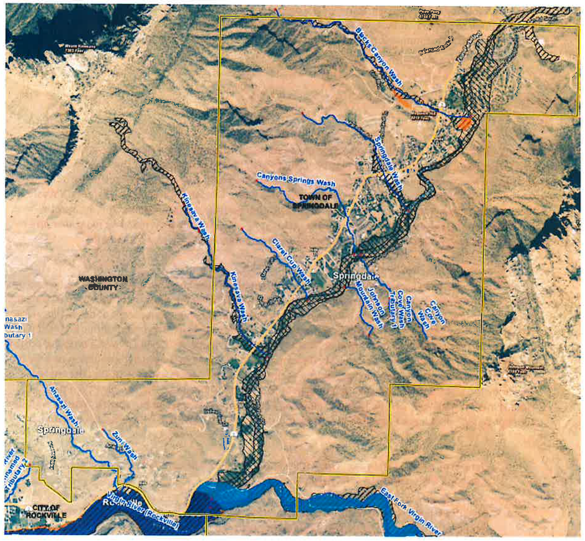
Figure 1
(b)
Disturbance of these washes that would result in them moving from a more desirable category to a less desirable category (as defined in paragraph (a) above) is permitted only in the following circumstances:
(1)
To create pedestrian or vehicular access or a driveway to lots or parcels which have no other means of access. In these cases, a culvert, pipe or other structure must be installed to allow the continued conveyance of stormwater through the wash. The design of such a structure must be based on engineering analysis. The structure must be designed to convey, at a minimum, the 0.5% annual exceedance probability flow (i.e. the one in 200 year flood event). The responsibility for maintenance of this structure rests with the property owner. Any such access or driveway shall be no wider than to allow emergency vehicle access as determined by the Fire Code.
(2)
To carry out maintenance or rehabilitation improvements for the purposes of flood risk reduction. This includes work to protect existing homes or other infrastructure from erosion damage. Any such improvements must be supported by engineering analysis to demonstrate that the improvements achieve the aims of flood or erosion risk reduction. Such work must be designed with natural solutions, bio-engineering, and soft bank armoring techniques where possible. Mechanical stabilization, hard armoring, and similar techniques (flood walls, rip-rap, etc.) are only allowed if natural solutions and bio-engineering are not feasible, as determined by the engineering analysis.
(3)
To install essential public infrastructure, where the Town Council determines that the need for the infrastructure outweighs the benefit of a wash remaining in its existing state. In these cases, a culvert, pipe or other structure must be installed to allow the continued conveyance of stormwater through the wash. The design of such a structure must be based on engineering analysis. The structure must be designed to convey, at a minimum, the 0.5% annual exceedance probability flow (i.e. the one in 200 year flood event).
(4)
For maintenance or repairs to existing pipes, culverts or concrete channels, so long as the improvements would not result in a less desirable condition of the wash, as defined in section 10-15B-14(a) above. Any such improvements must be supported by engineering analysis.
(c)
Notwithstanding the foregoing, none of the regulations pertaining to natural washes shall serve to nullify any other provision in this title. Where this article and another ordinance conflict or overlap, the more stringent restrictions shall prevail.
(Ord. No. 2024-04, 3-13-2024)