
Franklin Park City Zoning Code
CHAPTER 3
- Zoning Districts and Zoning Map
9-3-1.- Zoning districts.
To carry out the purpose and intent of this Ordinance, the Village of Franklin Park is divided into the following zoning districts:
A.
Residential districts.
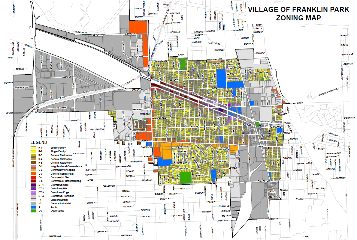
R-1 Single-Family Residential District
R-2 Single-Family Residential District
R-3 General Residence District
R-4 General Residence District
R-5 General Residence District
B.
Commercial districts.
C-1 Neighborhood Convenience District
C-2 Community Shopping District
C-3 General Commercial District
C-4 Commercial Flex District
C-5 Commercial Manufacturing District
C.
Downtown districts.
DT-1 Downtown Core District
DT-2 Downtown Mix District
DT-3 Downtown Edge District
DT-4 Downtown Transition District
D.
Industrial districts.
I-1 Light Industrial District
I-2 General Industrial District
E.
Special purpose districts.
P Public District
OS Open Space District
OCO O'Hare Corridor Business Opportunity Overlay District
9-3-2. - Zoning map.
A.
Location of districts.
1.
The location and boundaries of the zoning districts established by this Ordinance are set forth in the Official Zoning Map, which may be periodically amended. The Zoning Map is incorporated into, and made part of, this Ordinance.
2.
It is the intent of this Ordinance that the entire area of the Village is included in the Official Zoning Map and that all area is designated as one of the zoning districts established by this Ordinance. Any land within the Village that is not shown on the Zoning Map as being within a district shall be classified as the R-1 District.
B.
Interpretation of boundary lines.
1.
Right-of-way lines. Where zoning district boundary lines coincide with streets, highways, expressways, easements, or railroads, the boundary line is construed to be the centerline of the right-of-way.
2.
Property lines. Where zoning district boundary lines coincide with a recorded property line, the property line is construed to be the boundary line of the district.
3.
Scaled lines. Where the district boundary lines do not coincide with a right-of-way line or recorded property line, the district boundary is determined by measuring such boundary line(s) by using the map scale as provided on the Zoning Map.
4.
Clarification of boundary lines. The Zoning Administrator will decide any interpretations of zoning district boundary lines, where the application of this section is not clear as to the boundary between two (2) zoning districts.
9-3-3. - Exemptions for rights-of-way and public utilities.
A.
The provisions of this Ordinance do not apply to land located within the public right-of-way.
B.
The following utility uses are exempt from the provisions of this Ordinance and permitted in any district: wires, cables, conduits, vaults, laterals, pipes, mains, hydrants, valves, and water supply wells. This exemption does not include wireless telecommunications, amateur ham radio towers, solar panels, or wind turbines, unless operated by a government agency. All such structures must comply with this Ordinance and any other applicable Village ordinances.