
Herriman City Zoning Code
CHAPTER 10
15 OVERLAY ZONES
10-15-1 Environmental Contamination Overlay Zone
- Purpose. The purpose of this section is to provide for regulation of use and testing of soil on designated properties located within the city. Certain regulated contaminants have been identified in soil of residential and commercial properties within the city. Regulated contaminants pose a threat to the health and well-being of individuals who are exposed to soil having elevated levels of regulated contaminants. In particular, children are at risk from long-term exposure to regulated contaminants causing brain dysfunction and possible death. The city has identified certain areas where the regulated contaminants exceed prescribed levels in soil. Such areas have been identified by the U.S. Environmental Protection Agency and the city.
- Scope. The provisions of this section apply to all land within the contamination hazard special study areas in the city, as shown on the contamination map on file with the city. The contamination maps and all amendments thereto are made a part of this section as if fully described and detailed herein. These areas have been identified using existing Environmental Protection Agency testing data and supplemented with local testing data. These areas will be reviewed periodically as cleanup is continued in the city.
- Definitions. Certain words and phrases in this section are defined in HCC chapter 10-3.
- Action levels.
- Residential property. Action levels with respect to residential property located within a contamination area means soils having a lead concentration of 1,200 milligrams per kilogram (mg/kg) or more, and/or an arsenic level of 100 mg/kg or more.
- Nonresidential property. Action levels with respect to nonresidential property located within a contamination area means soils having a lead concentration of 4,000 mg/kg or more, and/or an arsenic level of 350 mg/kg or more.
- Prohibitions. It is unlawful for any person to:
- Develop or construct any new use upon a lot within the city without first ascertaining whether such lot is in a contamination area;
- Sell, assign, give or otherwise transfer land without providing written notice to the buyer, assignee or transferee of the presence of regulated contaminants in the soil of such land, if testing has occurred;
- Falsify, tamper with, alter, purify, or cause any activity to occur which will materially affect test samples or falsify, tamper with or alter soil test results;
- Knowingly withhold any information from the city regarding soil test sampling or test results; and
- Inhabit a new structure before properly abating all regulated contaminants.
- Permits.
- City responsibility. If a building permit is requested with respect to a lot located in a contamination area, the city shall provide the applicant with information necessary to perform required soil testing prior to disturbance, including the contaminants for which testing is required, a list of approved testing labs, and information pertaining to the possible human health hazards of regulated contaminants.
- Applicant responsibility. If a building permit is requested with respect to a lot located in a contamination area, the applicant shall have the soils tested by a qualified testing lab. If the lot is tested and found to exceed the action levels, the applicant shall submit a remediation plan to the city for approval prior to any development occurring or building permit being issued.
- Inspections and authority.
- Inspection procedure. The city reserves the right to establish and modify inspection procedures and standards for construction as it deems necessary to satisfy the purpose of this section.
- Property inspection. Representatives of the city may enter upon land in contamination areas at reasonable times to inspect, observe, measure, examine, survey, sample, and test the contamination area in order to enforce the provisions of this section.
- Test results. Any person conducting, or having conducted on their behalf, any required soil testing shall provide a complete copy of the test results to the city within five days of receiving the test results. If the city reasonably determines that a health hazard exists, based on the provided test results, the city shall have the right to conduct additional testing. All such test results shall be public records.
- Other applicable regulations. To the extent that use and development of land located in the environmental contamination overlay zone includes any matter governed by other applicable regulations set forth in this title, such regulations shall apply in addition to the requirements of this section. Should any part or provisions of this chapter be declared by the courts to be unconstitutional or invalid, such decision shall not affect the validity of the chapter as a whole or any part other than the part so declared to be unconstitutional or invalid.
(Code 2023, §§ 10-15A-1--10-15A-8; Ord. No. 2017-54, 12-13-2017; Ord. No. 2022-44, 11-9-2022)
10-15-2 Hillside Overlay Zone
- Purpose.
- The purpose of the hillside overlay zone is to protect the natural, scenic environment of the southern part of the city. The intent is to assist the development of the steep slopes in the South Mountain area to become a desirable and safe place to live and recreate.
- The city intends to preserve as much of the existing natural beauty as is feasible and still allow for compatible development. The natural resources should be taken advantage of without significantly detracting from the enjoyment of the hillside area.
- Scope.
- Applicability. The provisions of this section shall apply to all property located within the hillside overlay zone as shown on the official zoning map.
- Explanation of mapped area. The area of the hillside overlay zone was chosen after considering the unique nature and environment of South Mountain. The city outlined the area which has slopes greater than 30 percent grades and then included all lands south of the 30 percent line. The areas of greater elevation are also included in the hillside overlay zone because of their unique problems of access, water pressure zones, fire hazards, and special drainage challenges.
- Definitions. Certain words and phrases in this section are defined in HCC chapter 10-3.
- Uses allowed. The uses allowed on a lot in the hillside overlay zone shall be the same uses allowed in the underlying zone in which the lot is located.
- Development approval.
- Generally. The use and development of land located in the hillside overlay zone shall be approved according to applicable administration and development review procedures set forth in HCC chapter 10-5 except as modified by this section.
- Site plan approval. Any development in the hillside overlay zone shall be subject to approval of a site plan as provided in HCC 10-5-11.
- Approval by other agencies. Prior to site plan approval of any use in the hillside overlay zone, regardless of size or number of units, the applicant shall provide written evidence from the culinary water authority and the sanitary sewer authority certifying that water and sewer system requirements have been satisfied. The city may also request written evidence of approval from any agency having jurisdiction over the property proposed to be developed.
- Public support requirements. The needs of residents in the hillside overlay zone and the challenges of servicing unique sites may require specialized support of various public services. At the discretion of the city, special service districts may be created or required to service these needs. Property owners in the hillside overlay zone may therefore be required, to the extent lawfully authorized, to make property available for public facilities and public support operations to service proposed development as follows:
- Fire/emergency medical services substation;
- Police substation;
- Utility substation;
- Special service districts for water, sewer or public utilities;
- Road maintenance and erosion control; and
- Municipal services in general.
- Development standards.
- Generally. The development standards for a lot in the hillside overlay zone shall be the same as in the underlying zone in which the lot is located except as modified by this section.
- Steep slopes. No development, including clearing, excavation, and grading shall be permitted where the slope exceeds 30 percent. All areas with slope greater than 30 percent shall remain in natural private or public open space, except as allowed in this section.
- No grades greater than or equal to 30 percent slope may be modified to be less than 30 percent slope to create a new or additional developable area.
- Roads, trails, and other vehicular routes shall not cross slopes greater than 30 percent unless, after review by the planning commission, it is determined that:
- Appropriate engineering measures can be taken to minimize the impact of the cuts and fills, consistent with the purpose of this section; and
- The environment and aesthetics of the area will not be significantly affected.
- Retaining structures shall be required on all approved cuts or fills on 30 percent slopes to minimize disturbing of sloped areas.
- In no case shall public, private roads, or trails cross slopes over 50 percent unless, after review by the city council, it is determined that:
- The section of the road or trail that crosses slopes over 50 percent is less than 150 feet long; and
- It is found to be in the best interest of the city.
- Grading and drainage. No grading, excavation, or mass removal of vegetation or trees from a site shall be permitted, whether to provide for on site utilities or services, roads or driveways, or for building or other structural improvements on the site, until a grading permit has been issued pursuant to a grading and excavation plan and report for the site reviewed and approved by a qualified engineer within the city engineering department.
- Proposed grading shall be minimized to protect existing vegetation and natural drainage patterns, reduce any existing erosion, prevent any new erosion and dust during construction, and to minimize visual impacts. Slope stability and geotechnical review may be required as part of the application process.
- Natural drainage patterns shall be maintained to the greatest extent possible. The amount of water runoff currently moving from the project site to adjacent areas shall not exceed preconstruction levels.
- Alternative stormwater retention is encouraged to minimize runoff.
- Piping of waterways may only be done if a conditional use permit is approved by the planning commission.
- Buildings shall be designed to integrate into natural slopes.
- Mass grading to create flat building pads shall be prohibited.
- All cut and fill surfaces shall be regraded to match surrounding topography as closely as possible. When the regrading is not possible and a retaining system is proposed the material and the form shall fit into the hillside. Any retaining shall require a special geotechnical review and shall be designed by a licensed engineer unless the building department determines the amount of retaining does not require an engineered design.
- All cut and fill surfaces shall be replanted with native plants similar in type to plants that were removed. A special landscaping bond may be required to ensure slope stabilization and that the cut-fill surfaces have been revegetated.
- Natural drainage patterns shall be maintained to the greatest extent possible. The amount of water runoff currently moving from the project site to adjacent areas shall not exceed preconstruction levels.
- The development shall maintain proper erosion controls during construction. All development shall be required to have a UPDES permit from the state and shall comply with all city and state SWPP guidelines.
- Proposed grading shall be minimized to protect existing vegetation and natural drainage patterns, reduce any existing erosion, prevent any new erosion and dust during construction, and to minimize visual impacts. Slope stability and geotechnical review may be required as part of the application process.
- Ridgeline preservation. Ridgelines should be retained in a natural state. Private structures may be developed only at a distance of 60 feet from the ridgeline.
- Development near designated ridgelines as shown on the official city zoning map should be sited and constructed to avoid creating a silhouette against the sky or backdrop when viewed from the following designated vantage points:
- 5600 West and 13400 South.
- 6400 West and 13400 South.
- 7000 West and Rose Canyon Road.
- Bangerter Highway and 13400 South.
- Additional vantage points pertinent to the project may be requested by the planning commission. Public utilities may be an exception to this requirement.
- Development near designated ridgelines as shown on the official city zoning map should be sited and constructed to avoid creating a silhouette against the sky or backdrop when viewed from the following designated vantage points:
- Limits of disturbance. For every development subject to this section, the planning department shall ensure that limits of disturbance indicating specific areas of a proposed development site within which construction and development activities are to be contained are established.
- For single-family residential development, limits of disturbance shall include the area required for principal structure, any accessory structures, utilities, services, and drainage facilities, but shall not include areas required for driveways.
- The following standards shall be utilized in establishing limits of disturbance on a proposed development site:
- Minimize visual impacts from the development through such site design considerations as screening from adjacent and downhill properties, ridgeline area protection and protection of scenic views.
- Erosion prevention and control, including, but not limited to, protection of steep slopes and natural drainage channels.
- Fire prevention and safety, including, but not limited to, location of trees and vegetation near structures.
- Preservation of significant trees or vegetation.
- Conservation of water including, but not limited to, preservation of existing native vegetation, reduction in amounts of irrigated areas, and similar considerations.
- Wildlife habitat protection, including, but not limited to, preservation critical to wildlife habitat and identified migration corridors and routes.
- Stream corridor and wetland protection and buffering.
- Preservation of maximum amounts of the site's natural topography, tree cover, and vegetation.
- Dust prevention plan.
- Limits of disturbance necessary to accommodate proposed development may be noncontiguous in order to best meet the criteria and standards set forth in this subsection (F)(5).
- Landscaping and native vegetation. Existing vegetation shall be protected in its natural state to the greatest extent possible.
- All trees over six inches in caliper or plants over ten feet tall shall be noted on plans and marked in the field for the duration of construction. Any grading or land disturbance shall maintain a distance of ten feet from any marked tree or shrub.
- All clearing of existing vegetation shall be a conditional use, subject to planning commission approval. Clearing outside the limits of disturbance shall be prohibited.
- Native compatible trees and vegetation shall be utilized in new landscaping.
- New landscaping shall be designed to minimize the threat of wildfire to built structures and encourage low water usage vegetation.
- Before grading commences, all vegetation that is not permitted to be removed shall be marked with "caution" tape and inspected.
- Street design. Streets, roads, private access roads, driveways, and other vehicular routes shall be designed to minimize the amount of disturbance while allowing safe access.
- Vehicular routes shall not cross slopes greater than 50 percent; unless granted an exception under subsection (F)(2)(d) of this section.
- Vehicular routes shall follow natural contour lines to the greatest extent feasible to minimize cut and fill and disturbance to existing vegetation.
- Driveways shall have a maximum grade of 12 percent and shall comply with city development standards. The standards should include not grading the driveway toward the dwelling as well as roadway widths, types of drainage, sidewalk design, and radius of curves.
- Access for fire protection shall be provided from public streets to the rear of development which back onto open space.
- Building design.
- Proposed structures shall be complementary to the surrounding landscape in terms of scale, massing, roof shape, and exterior materials.
- Buildings shall not create large bulky masses, but should be scaled down into groupings of smaller attached structures.
- Buildings shall be placed on the site and designed to minimize adverse effects on adjacent properties.
- Buildings should be sited so as not to visually break the ridgeline as set forth in subsection (F)(4) of this section.
- Buildings shall be sited and constructed to resist wildfire. Applicants may be required to complete a technical analysis for the Unified Fire Authority to evaluate the safety of a proposal and mitigate safety impacts.
- Except as otherwise specifically provided in this title, all buildings and structures shall not exceed 35 feet in height from the lowest finished grade touching the building to the midline of the roof. Where the grade slopes, this dimension shall not be exceeded at any point along the slope.
- Building materials. Buildings shall be designed to complement the natural beauty of the surrounding landscape.
- Buildings and accessory structures shall follow a consistent theme, focused on natural materials and colors to blend with the surrounding landscape.
- Harmonious appearing materials shall be used. The use of bland, unpainted concrete blocks and unpainted metal shall be prohibited on exterior surfaces.
- Materials, colors, and surfaces shall have little or no reflectivity.
- Parking. Parking areas shall not exceed a maximum of 25 stalls and are to be divided by both grade and plantings.
- Fences. Fences should be used to the minimum extent possible to limit their visual impact and allow access to public areas, as needed.
- No fence shall be constructed unless shown on an approved site development plan.
- No fence in excess of 48 inches in height shall be constructed or installed outside designated limits of disturbance, except as required by city for uses such as corrals for permitted animals.
- Fences in front yards and along roadways shall not exceed 48 inches in height.
- Fences shall not inhibit the movement of wildlife along known travel corridors.
- Wildfire hazards. In areas determined by the Unified Fire Authority as being highly susceptible to fire hazards, vegetation up to 30 feet from the perimeter of a structure shall be selectively pruned and thinned for fire protection purposes.
- Lighting. Lighting shall be limited to promoting safety and visibility as necessary.
- Outdoor lighting, including yard and house lighting, shall be shielded or hooded to prevent glare onto adjacent properties and minimize the amount of light directed toward the sky.
- Selective lighting of signs shall be allowed to assist in visibility only.
- A greater number of smaller light fixtures shall be used instead of large, high-intensity fixtures.
- Utilities. Above-grade wires or fiber shall be prohibited. All utilities shall be buried underground for protection from natural elements and to be visually unobtrusive. Utility location and service shall be coordinated with the city, as needed, as set forth in subsection (D)(4) of this section. Exceptions may be granted for city infrastructure.
- Access to recreation and public land. For the benefit of residents and visitors, the city shall protect access to existing and future recreation areas, such as public lands and trails and, to the extent lawfully authorized, may require easements through areas proposed for development as needed to permit access.
- Wildlife habitat. Protecting wildlife and their natural habitats is important for maintaining the natural ecosystem and for the enjoyment of residents and visitors.
- Proposals in the hillside overlay zone shall note important natural features and vegetation that serve as habitat, and identify wildlife that may be present in different seasons.
- Site plans should minimize the impact of development by:
- Siting buildings, structures, roads, trails, and other construction to avoid significant natural features and to maintain a sufficient buffer between these important natural areas and human activity;
- Facilitate wildlife movement by designing natural corridors between natural areas and by minimizing fences and road crossings;
- Maintaining the natural structure of the site, different layers of vegetation;
- Revegetating degraded areas with native plants; and
- Selecting plants that benefit wildlife for new landscaped areas.
- Other applicable regulations. To the extent that use and development of land located in the hillside overlay zone includes any matter governed by other applicable regulations set forth in this title, such regulations shall apply in addition to the requirements of this section.
(Code 2023, §§ 10-15B-1--10-15B-7; Ord. No. 2017-54, 12-13-2017; Ord. No. 2022-46, 12-14-2022)
10-15-3 Planned Development Overlay Zone
- Purpose. The purpose of a planned development is to allow diversification in the relationship of various uses and structures on a particular site and to permit flexibility in the use of the site. The application of the planned development concept is intended to encourage good neighborhood, housing, and area design, thus ensuring substantial compliance with the intent of zone regulations and other provisions of this title related to public health, safety, and general welfare, and at the same time securing the advantages of large scale site planning for residential, commercial, or industrial development, or combinations thereof.
- Scope. The provisions of this section shall apply to all property located within the planned development overlay zone as shown on the official zoning map.
- Definitions. Certain words and phrases in this section are defined in HCC chapter 10-3.
- Uses allowed. The uses allowed on any lot in the planned development overlay zone shall be the same uses allowed in the underlying zone in which the lot is located.
- Development approval.
- Generally. The use and development of land located in the planned development overlay zone shall be approved according to applicable administration and development review procedures applicable to the underlying zone set forth in this title except as modified by this section.
- The planned development overlay zone may be used in combination with any zone subject to the requirements of this section. The provisions of the planned development overlay zone shall be supplementary to the provisions of the zone with which it is combined and shall not be applied to any land area as an independent zone.
- Variations from applicable development standards of an underlying zone may be approved for a planned development pursuant to the provisions of this section.
- Preliminary site plan approval. A preliminary site plan shall be submitted and considered concurrently with an application for approval of a planned development overlay zone. Such plan shall be considered pursuant to provisions of HCC 10-5-11 except as modified by this section.
- The preliminary site plan shall show:
- Generally, the proposed residential use density, minimum lot sizes, the range of average lot sizes, building locations, building elevations, open space to comply with subsection (F)(10) of this section, parking, landscaping, pedestrian and traffic circulation, drainage, and utility layout; and
- The information required by HCC 10-5-11, except that plans for grading and drainage, utilities, landscaping, and building elevations may be conceptual in nature.
- If the planned development is proposed to be developed in phases, the preliminary site plan shall also show phase boundaries. Each phase shall be of such size, composition, and arrangement so that construction, marketing, and operation of each phase is feasible as a unit, independent of any subsequent phases.
- A planned development shall be in single ownership and control or under option to purchase by an individual or a corporate entity at the time of application, or the application shall be filed jointly by all owners of the property.
- The planning commission shall make a recommendation to the city council regarding the proposed planned development overlay zone as required by HCC chapter 10-5. At the same time, the planning commission shall approve, approve with conditions, or disapprove a preliminary site plan for property where the planned development is proposed to be located. Planning commission approval of a preliminary site plan shall not be effective unless and until a corresponding planned development zone is approved by the city council.
- The preliminary site plan shall show:
- Zone change. After action by the planning commission, the city council shall consider the application for a planned development overlay zone as provided in HCC chapter 10-5 regarding amendment of the official zoning map.
- Submittal of an application for a planned development overlay zone does not guarantee the application will be approved. A zoning map amendment may be approved only if the city council, after receiving a recommendation from the planning commission, finds the proposed planned development overlay zone and the associated preliminary site plan:
- Do not conflict with any applicable policy of the general plan;
- Meet the spirit and intent of this section;
- Will allow integrated planning and design of the site and, on the whole, better development than would be possible under conventional zoning regulations;
- Meets the density, use, and other requirements of this section and the zone with which the planned development overlay zone will be combined, except as otherwise allowed by this section.
- In order to make findings necessary to approve a planned development overlay zone, conditions of approval may be imposed to ensure the planned development will:
- Accomplish the purpose of this section;
- Be developed as one integrated land use rather than as an aggregation of individual and unrelated buildings and uses; and
- Meet the requirements of the zone in which the proposed development is located except as such requirements are modified by this section and as shown on an approved preliminary site plan for the planned development.
- Zoning conditions, as provided in HCC 10-5-8(F), also may be placed on property at the time of zoning to restrict or prohibit uses or development that would not be compatible with adjoining uses, notwithstanding whether such uses are existing or future uses as shown in the general plan.
- Submittal of an application for a planned development overlay zone does not guarantee the application will be approved. A zoning map amendment may be approved only if the city council, after receiving a recommendation from the planning commission, finds the proposed planned development overlay zone and the associated preliminary site plan:
- Site plan approval. Within 24 months after approval of a planned development overlay zone and a corresponding preliminary site plan, and before the issuance of any building permit, an applicant shall submit an application for approval of a site plan pursuant to HCC 10-5-11. If a planned development is to be constructed in phases as shown on an approved preliminary site plan, a site plan shall be submitted for each phase.
- Subdivision requirements. An application for subdivision approval may proceed concurrently with an application for a site plan approval. Compliance with the requirements of this section does not exempt any applicant from meeting other applicable requirements of this title.
- Construction limitations. Upon approval of a site plan for a planned development, construction shall proceed in accordance with approved plans and specifications, and in conformity with any conditions associated with the preliminary site plan, zone change, or site plan approval.
- Amendments. Amendments to approved plans shall be obtained by following the same procedure required for the original approval.
- Development agreement. In conjunction with approval of a preliminary site plan or a zone change application, the city may elect to enter into a development agreement with the owner of a proposed planned unit development which includes the following provisions.
- Upon approval of a preliminary site plan and a related development agreement, the preliminary site plan shall vest in the owner the right to develop the subject property as a planned unit development, subject to the right of the planning commission to approve a site plan as provided in this section, within the parameters set forth in the approved preliminary site plan and approved development agreement.
- The development agreement may, among other things, provide that:
- The land subject to the preliminary site plan may be subdivided and the subdivided tracts may be sold to different owners;
- Each individual owner of a tract within the property may submit separate site plan applications which shall be independently reviewed, provided such that such applications conform to applicable requirements of the approved site plan for the associated planned development; and
- Any grading and drainage plans, landscaping, fencing, and screening plans, signs and floodlighting, and site plans will be required as part of the site plan approval.
- Expiration of preliminary site plan. An approved preliminary site plan shall not expire if a corresponding planned development overlay zone is approved by the city council.
- Generally. The use and development of land located in the planned development overlay zone shall be approved according to applicable administration and development review procedures applicable to the underlying zone set forth in this title except as modified by this section.
- Development standards.
- Generally. The development standards for any lot in the planned development overlay zone shall be the same as in the underlying zone in which the lot is located except as modified by this section and an approved site plan.
- Minimum area. No planned unit development shall have an area of less than 15 acres.
- Density. Total density of dwelling units shall not exceed the density allowed in the underlying zone in which the planned unit development is located. Density shall be determined by calculating the number of dwelling units that could be developed on lots in a conventional subdivision under the provisions of the underlying zone where the planned development will be located.
- Effect on adjacent properties. The arrangement of structures and open spaces within a planned development shall ensure that adjacent properties will not be adversely affected.
- Height and intensity of buildings and uses shall be arranged around the boundaries of the planned unit development in a manner compatible with existing adjacent developments and zones.
- Buildings located on the periphery of the development shall be limited to a maximum height of two stories.
- Lot area and width. A planned development shall not be subject to the lot width and lot area requirements of the underlying zone in which the development is located. Lot area and widths shall be shown on an approved site plan.
- Lot and dwelling location requirements.
- Where possible, views of dwelling lots from exterior roads and abutting properties should be minimized by the use of changes in topography, existing vegetation, or additional landscaping which meets requirements of the underlying zone where the planned development will be located.
- Where possible, dwelling lots should be accessed from interior streets rather than from streets bordering a planned development.
- Tract perimeter setback and buffer requirements. Structures shall be situated so as to maintain a minimum setback from any property line equivalent to the front yard setback of the underlying zone. When a site adjoins land used for single-family dwellings, a landscape buffer 30 feet in width shall be provided. Such buffer shall meet the development standards of the underlying zone where the planned development is located.
- Walls and fences. Walls and fences shall conform to the requirements of HCC chapter 10-21 and shall be required around the perimeter of a planned development where the development abuts an adjacent zone.
- Height of buildings. Maximum building height shall not exceed the height limits of the underlying zone where the planned development will be located.
- Preservation of open space. The location and amenities of all required open space shall be reviewed and approved as part of the preliminary site plan process.
- At least 20 percent of the planned unit development shall be preserved as permanent open space.
- At least one-half of the open space required shall be maintained in single contiguous lot, not including any unbuildable property, configured in a usable size and shape.
- Open space that is unbuildable because of, among other things, slope, wetlands, flood drainage, or contamination shall be counted at 25 percent of the acreage required to satisfy applicable open space requirements.
- Detention basins may count as open space only if they provide recreational amenities, including, but not limited to, playgrounds, gazebos, exercise stations, or sports fields with parking lots.
- Park strips adjacent to a street shall not count as open space.
- A method approved by the city to maintain open space shall be established prior to sale of any lots in a planned unit development. Preservation, maintenance, and ownership of required open spaces within the development may be accomplished by:
- Dedication of the land as a public park or parkway system;
- Granting to the city a permanent open space easement on or over the private open spaces to guarantee that the open space remains perpetually in recreational use, with ownership and maintenance being the responsibility of the owner or an owners' association established with bylaws which are satisfactory to the city; or
- Compliance with the provisions of the Utah Condominium Ownership Act (U.C.A. 1953, § 57-8-1 et seq.) which provides for payment of expenses for upkeep of common areas and facilities.
- Open space may be provided in a location outside of the boundaries of the planned development overlay zone, if the following requirements are met:
- The off-site open space must be located within city limits.
- Open space that is unbuildable because of, among other things, slope, wetlands, flood drainage or contamination shall be counted at 25 percent of the actual acreage to satisfy applicable open space requirements. Detention basins may only count as open space if they provide recreational amenities.
- The location and amenities of all the required open space shall be reviewed and recommended by the planning commission as part of the planned development overlay zone process.
- The off-site open space shall be approved by the city council as part of the planned development overlay zone process.
- A portion of the open space may be required to remain within the boundaries of the planned development overlay zone.
- A fee in lieu of required open space may be provided if the following requirements are met:
- The amount of acreage that is required as open space shall be reviewed and recommended by the planning commission as part of the planned development overlay zone process.
- The fee in lieu of shall be determined by an appraised price per acre and the amount shall be approved by the city council.
- The fee shall be designated as parks funds and shall be used to purchase or improve property for parks in other areas of the city.
- A portion of the open space may be required to remain within the boundaries of the planned development overlay zone.
- At least 20 percent of the planned unit development shall be preserved as permanent open space.
- Public and community facilities. In addition to dwellings and commercial facilities allowed by the underlying zone, a planned development may include areas for schools, churches, public or private recreation buildings, and other similar community facilities.
- Required improvements.
- All streets in a planned development shall be constructed according to city standards and specifications adopted by the city, except that the minimum width of such streets may be reduced as shown on an approved site plan.
- Curb and gutter shall be required along each side of all streets except where:
- An approved stormwater management system eliminates the necessity of the curb and gutter function; and
- The street is approved for construction according to city standards and specifications.
- Sidewalks shall be installed along both sides of all streets except where alternate pedestrian ways are provided as part of an approved site plan.
- Stormwater shall be controlled and managed according to a plan approved by the city.
- Infrastructure improvements, including, but not limited to, utilities, irrigation, street signs, street lighting, fencing, and other required improvements, shall be provided in accordance with city standards and specifications.
- Grading and drainage plans. A detailed grading and drainage plan shall be submitted as part of a site plan application.
- Landscaping, fencing and screening requirements.
- Landscaping, fencing, and screening shall relate to the site's land uses serve to integrate the proposed development into its surroundings and shall be submitted as part of a site plan application.
- Where a specific nonvisual barrier fence is required within a planned development, double fencing shall not be installed within six feet of an existing fence.
- Signs and floodlighting. The size, location, design, and nature of signs, if any, and the intensity and direction of area floodlighting, shall be detailed in a site plan application.
- Other applicable regulations. To the extent that use and development of land located in a planned development overlay zone includes any matter governed by other applicable regulations set forth in this title, such regulations shall apply in addition to the requirements of this section.
(Code 2023, §§ 10-15C-1--10-15C-7; Ord. No. 2017-54, 12-13-2017; Ord. No. 2018-12, 3-14-2018)
10-15-4 Wind Energy Facilities Overlay Zone
- Purpose. The purpose of this section is to provide regulations for the safe and effective construction and operation of wind energy facilities in the city, subject to reasonable restrictions, which will preserve the public health and safety. The planning commission and city council make the following findings:
- That wind energy is an abundant, renewable and nonpolluting energy resource.
- That the conversion of wind to electricity will reduce the city's dependence on nonrenewable energy resources and decrease the air and water pollution that results from the use of conventional energy sources.
- That wind energy systems enhance the reliability and power quality of the power grid, reduce peak power demands and help diversify energy supply.
- The unnecessary proliferation of wind energy facilities throughout the city creates a negative visual impact (visual pollution) on the community.
- The visual effects of wind energy facilities can be mitigated by fair standards regulating their siting, construction, maintenance and use.
- Scope. The provisions of this section shall apply to all property located within the wind energy facilities overlay zone as shown on the official zoning map.
- Definitions. Certain words and phrases in this section are defined in HCC chapter 10-3.
- Uses allowed. The uses allowed on a lot in the wind energy facilities overlay zone shall be the same uses allowed in the underlying zone in which the lot is located.
- Development approval.
- Generally. The use and development of land located in the wind energy facilities overlay zone shall be approved according to applicable administration and development review procedures set forth in HCC chapter 10-5 except as modified by this section.
- Concept plan. A concept plan shall be submitted and approved prior to a request for a wind overlay zone. An application for a concept plan shall be considered pursuant to provisions of HCC chapter 10-5 governing an application for a site plan, except as follows:
- The concept plan shall show generally the proposed wind energy facilities, building locations, building elevations, open space, parking, landscaping, pedestrian and traffic circulation, drainage, and utility layout.
- The planning commission shall not approve a concept plan for a wind energy facility but shall make a recommendation to the city council concerning the plan.
- Upon receiving the planning commission's recommendation, the city council shall approve, approve with conditions, or disapprove the concept plan.
- An application for a wind energy facilities overlay zone may be submitted following approval or conditional approval of the concept plan.
- An approved concept plan shall expire 12 months after approval, unless prior to expiration, a zone change application is submitted as provided in subsection (E)(3) of this section. If the application is not approved, the associated concept plan shall expire 12 months after approval.
- Zone change. A wind energy facilities overlay zone shall be established pursuant to the procedures for amending the official zoning map, as provided in HCC 10-5-8. Requests for a wind overlay zone shall be submitted concurrently with an application for a conditional use permit and a site plan for a wind energy facility.
- Wind energy facilities may be allowed only in a wind overlay zone as a conditional use.
- Wind overlay zones may be created only in manufacturing, forestry recreation, or large lot residential and agricultural zones.
- No wind overlay zone may be initially created without a specific request for wind energy facilities. Requests for a wind overlay zone shall be submitted concurrently with an application for site plan for a wind energy facility.
- Once a wind overlay zone has been created, new wind energy facilities or accessory structures or facilities may be allowed in that zone as a conditional use.
- Site plan. Any development in the wind energy facilities zone shall be subject to approval of a site plan as provided in HCC 10-5-11.
- Conditional use. The conditional use permit procedure set forth in HCC 10-5-10 shall be applied to wind energy facilities.
- Additional information required. An application for a wind energy facility shall include the following as part of an application for approval of a conditional use permit and a site plan:
- A written description of the project, including the number and maximum rated capacity of each wind energy facility. For each proposed wind energy facility, include make, model, picture and manufacturer's specifications, including noise decibels data.
- A plot plan prepared by a licensed surveyor or engineer drawn at an appropriate scale and in sufficient detail to clearly describe the following:
- Proposed boundaries of the wind overlay zone with an accompanying legal description.
- Location of all proposed wind turbines with circles drawn around each one demonstrating compliance with the setback requirements of this section.
- The location of the proposed wind energy facility as it relates to the boundaries of the lot, adjacent ownerships and existing residences, schools, churches, hospitals, libraries, parks, and public places to a distance of 2,000 feet.
- All proposed facilities, including access roads, electrical lines, substations, storage or maintenance units.
- Any federal, state, county, or local recognized historic or heritage sites, delineated wetlands, and important bird areas as identified in federal, state, county, or local GIS databases or other generally available documentation.
- Proposed landscaping, screening, and fencing.
- A vertical drawing of each wind turbine showing total height, turbine dimensions, tower and turbine colors, ladders, distance between ground and lowest point of any blade, location of climbing pegs, and access doors. A single drawing may be submitted for each wind turbine of the same type and total height.
- A lighting plan showing any Federal Aviation Administration required lighting and other proposed lighting.
- Information relating to the construction and installation of the wind energy facility, including a construction schedule describing commencement and completion dates, and a description of the routes to be used by construction and delivery vehicles with the gross weights and heights of those loaded vehicles.
- A visual impact study of the proposed wind energy facility as installed, which should include computerized before and after photo simulations, elevation drawings showing the height, design, color, night lighting, etc., and the location of the proposed facility as viewed from the zone of visual influence. The zone of visual influence shall extend three miles from the facility. The visual analysis shall also indicate any visual screening incorporated into the project intended to lessen the facility's visual prominence.
- A wind or feasibility study that recommends specific locations for all wind turbines. The study shall also recommend an optimal height for all wind turbines and if the location is feasible for wind turbines.
- A study on potential shadow flicker that identifies locations where shadow flicker may be caused by the wind energy facility and the expected durations of the flicker at these locations. The study shall identify areas where shadow flicker may interfere with residences and describe measures that shall be taken to eliminate or mitigate the problems. If the turbine is located farther than three times its height from any vertical structure, no study is required for shadow flicker.
- A noise analysis prepared by a competent acoustical consultant documenting noise levels associated with the proposed wind energy facility. The study shall document noise levels at property lines and at the nearest residence or public building or use not on the site. As part of the study, a base line shall be established on the site for future reference.
- An assessment of potential electromagnetic interference with microwave, radio, television, personal communication systems, and other wireless communication.
- A fire protection and emergency response plan, created in consultation with the Unified Fire Authority.
- A decommissioning plan, which shall include:
- The anticipated life of the wind energy facility;
- The estimated decommissioning costs in current dollars;
- How the estimate was determined;
- The method of ensuring funds will be available for decommissioning and restoration;
- The method, such as by annual re-estimate by a licensed engineer, by which decommissioning cost will be kept current; and
- The manner in which the wind energy facility will be decommissioned and the site restored.
- Development standards.
- Generally. The development standards for a lot in the wind energy facilities overlay zone shall be the same as in the underlying zone in which the lot is located except as modified by this section.
- Wind energy facilities. The development standards set forth in this subsection (F) shall apply to wind energy facilities in addition to the development standards outlined in the underlying zone except as modified by this section.
- Lot size. A wind energy facility shall be located on a lot at least ten acres in size plus one additional acre per wind turbine.
- Visual appearance; lighting; power lines.
- The design of wind energy facilities, including any buildings or related structures, shall to the extent reasonably possible use materials, colors, textures, screening and landscaping that will help reduce the visual impact of the wind energy facility.
- Wind energy facilities shall use tubular towers. The use of guywires shall be prohibited.
- Individual wind energy facilities within a wind overlay zone shall be constructed using wind turbines whose appearance, with respect to one another, is similar within and throughout the zone, to provide reasonable uniformity in overall size, geometry, and rotational speeds.
- All wind turbines and other structures shall be finished in a single, nonreflective matte finished color or a camouflage scheme.
- Advertising signs shall be prohibited on any part of the wind energy facility, including fencing, support structures, and wind turbines, except for reasonable identification of the manufacturer or operator of the wind energy facility. No lettering, company insignia, advertising, or graphics shall be on any part of the tower, hub, or blades.
- Wind energy facilities shall not be artificially lighted, except to the extent required by the Federal Aviation Administration or other applicable authority.
- Electrical controls and control wiring and power lines shall be wireless or underground except where wind energy facility collector wiring is brought together for connection to the transmission or distribution network.
- Setbacks. The following setbacks and separation requirements shall apply to all wind turbines; provided, however, that the planning commission may reduce the standard setbacks and separation requirements if the intent of this subsection (F) would be better served thereby:
- Each wind turbine shall be set back 2,000 feet from the nearest residential or agricultural zoning district, school, church, public park or public library.
- Each wind turbine shall be set back from the nearest property line a distance no less than 1.1 times its total height, unless appropriate easements are secured from adjacent property owners, or other acceptable mitigation is approved by the planning commission.
- Each wind turbine shall be set back from the nearest public road a distance no less than 1.2 times its total height, determined at the nearest boundary of the underlying right-of-way for such public road.
- Each wind turbine shall be set back from the nearest above-ground public electric power line or telephone line a distance no less than 1.2 times its total height, determined from the existing power line or telephone line.
- Each wind turbine shall be set back 500 feet from any wetlands delineated by the U.S. Army Corps of Engineers. This distance may be adjusted to be greater or lesser at the discretion of the reviewing body, based on topography, land cover, land uses, and other factors that influence the flight patterns of resident birds.
- Noise. Audible noise due to wind energy facility operations shall not exceed 55 dBA for any period of time measured at the wind energy facility site's property line.
- Height. The total height for a wind turbine shall not exceed 400 feet.
- Density. No more than one turbine per acre shall be allowed.
- Braking device. All wind turbines shall have braking systems when winds reach speeds in excess of 65 miles per hour or as otherwise required by industry standards.
- Signal interference. The applicant shall minimize or mitigate any interference with electromagnetic communications, such as radio, telephone or television signals caused by any wind energy facility.
- Safety.
- Wind turbine towers shall not be climbable up to 12 feet above ground level.
- All access doors to wind turbine towers and electrical equipment shall be lockable.
- Appropriate warning signage shall be placed on wind turbine towers, electrical equipment, and wind energy facility entrances. Such signage shall include emergency contact information.
- Each wind energy facility shall be equipped with both manual and automatic controls to limit the rotational speed of the rotor blade so it does not exceed the design limits of the rotor.
- The minimum distance between the ground and any part of the rotor or blade system shall be 20 feet.
- Compliance with International Building Code (IBC). All wind turbines and associated buildings and facilities shall comply with all applicable International Building Code requirements. Building permit applications for wind energy facilities shall be accompanied by a standard drawing of the wind turbine structure including the tower, base, and footing. An engineering analysis of the tower showing compliance with the building code and certified by a licensed professional engineer registered in the state shall also be submitted. In the case of a conflict between the IBC and this section, the more restrictive shall apply.
- Compliance with FAA regulations. Wind energy facilities shall comply with applicable Federal Aviation Administration regulations.
- Small wind energy facilities. The development standards set forth in this subsection (F) shall apply to small wind energy facilities in addition to development standards set forth in an underlying zone except as modified by this section.
- Small wind energy facilities shall be located on a lot at least one acre in size. However, this requirement may be met by multiple owners submitting a joint application. Small wind energy facilities may be allowed on sites of three acres or more upon issuance of a conditional use permit.
- In conjunction with the application requirements for a conditional use permit and site plan, an application for a small wind energy facility shall include the following:
- Evidence that the proposed tower height does not exceed the height recommended by the manufacturer or distributor of the facility.
- A line drawing of the electrical components of the facility in sufficient detail to allow for a determination that the manner of installation conforms to the electric code.
- Sufficient information demonstrating that the facility will be used primarily to reduce on site consumption of electricity.
- Written evidence that the electric utility service provider that serves the proposed site has been informed of the applicant's intent to install an interconnected customer owned electricity generator, unless the applicant does not plan, and so states in the application, to connect the facility to the electricity grid.
- A visual analysis of the small wind energy facility as installed, which may include a computerized photographic simulation, demonstrating the visual impacts from nearby strategic vantage points. The visual analysis shall also indicate the color treatment of the facility's components and any visual screening incorporated into the project that is intended to lessen the facility's visual prominence.
- A decommissioning plan, if required by the city, that includes the following:
- The anticipated life of the small wind energy facility;
- The estimated decommissioning costs in current dollars;
- How the estimate was determined;
- The method of ensuring funds will be available for decommissioning and restoration; and
- The manner in which the wind energy facility will be decommissioned and the site restored.
- Tower heights shall be allowed as follows:
- Any tower height under 35 feet shall be a permitted use.
- Maximum height shall be 80 feet.
- The allowed height shall be reduced if necessary to comply with applicable federal aviation requirements.
- A small wind energy facility shall not be located closer to a lot line than 1.2 times the total height of the facility.
- The maximum turbine power output shall be limited to 30 kilowatts.
- The facility's tower and blades shall be painted or treated with a nonreflective, unobtrusive color that blends the facility and its components into the surrounding landscape to the greatest extent possible and incorporate nonreflective surfaces to minimize any visual disruption.
- The facility shall be designed and located in such a manner to minimize adverse visual impacts from public viewing areas (e.g., public parks, roads, trails). To the greatest extent feasible, a small wind energy facility shall not project above the top of ridgelines.
- Exterior lighting on any structure associated with the facility shall not be allowed except that which is specifically required by the Federal Aviation Administration.
- All on-site electrical wires associated with the facility shall be installed underground except for tie-ins to a public utility company and public utility company transmission poles, towers, and lines. This standard may be modified by the planning commission if the project terrain is determined to be unsuitable due to reasons of excessive grading, biological impacts, or similar factors.
- The facility shall be operated to avoid disruptive electromagnetic interference. If it is demonstrated that a facility is causing harmful interference, the facility operator shall promptly mitigate the harmful interference or cease operation of the facility.
- At least one sign shall be posted on the tower at a height of five feet warning of electrical shock or high voltage and harm from revolving machinery.
- No brand names, logo, or advertising shall be placed or painted on the tower, rotor, generator, or tail vane where it would be visible from the ground, except that a facility or tower's manufacturer's logo may be displayed on a facility generator housing in an unobtrusive manner.
- Towers shall be constructed to provide one of the following means of access control:
- Tower climbing apparatus located no closer than 12 feet from the ground.
- A locked anti-climb device installed on the tower.
- A locked, protective fence at least six feet in height that encloses the tower.
- Anchor points for any guywires for a facility tower shall be located within the lot on which the facility is located and not on or across any above-ground electric transmission or distribution lines. The point of attachment for the guywires shall be enclosed by a fence six feet high or sheathed in bright orange or yellow covering from three feet to eight feet above the ground.
- To prevent harmful wind turbulence from existing structures, the minimum height of the lowest part of any horizontal axis wind turbine blade shall be at least 30 feet above the highest structure or tree within a 250-foot radius. Modification of this standard may be made when the applicant demonstrates that a lower height will not jeopardize the safety of the wind turbine structure.
- All small wind energy facility tower structures shall be designed and constructed in compliance with pertinent provisions of the International Building Code, National Electrical Code, and any other applicable codes.
- All small wind energy facilities shall be equipped with manual and automatic overspeed controls. The conformance of rotor and overspeed control design and fabrication with good engineering practices shall be certified by the manufacturer.
- Except during short term events including utility outages and high wind warnings (events 35+ mph), a small wind energy facility shall be designed, installed, and operated so that noise generated by the facility shall not exceed 50 decibels, as measured at the closest neighboring dwelling.
- Maintenance. All wind energy facilities and small wind energy facilities shall be maintained in good condition and in accordance with all requirements of this section.
- Other applicable regulations. To the extent that use and development of land located in the wind energy facilities overlay zone includes any matter governed by other applicable regulations set forth in this title, such regulations shall apply in addition to the requirements of this section.
(Code 2023, §§ 10-15D-1--10-15D-7; Ord. No. 2017-54, 12-13-2017)
10-15-5 Sports And Entertainment Mixed Use Overlay Zone
- Purpose. The purpose of the Sports and Entertainment Mixed Use (SEMU) Overlay Zone is to:
- Facilitate development of a master planned area for international sports training and associated commercial, educational, and office uses, including, but not limited to, exhibition events, community events, educational activities, and other mixed uses which are consistent with a national sports and training area.
- Recognize the uniqueness of significant sports and entertainment complexes and encourage the development of operations of those facilities.
- Encourage flexible and creative development in order to offer a unique experience in a high-quality, visitor-friendly setting that contains a complementary mixture of land uses that enhance the experience of the place.
- Support destination facilities and venues that encourage tourists from outside the city, including commercial, office, and recreational uses.
- Applicability. The provisions of this section shall apply to all land located within the SEMU overlay zone as shown on the official zoning map.
- Permitted and conditional uses. Only the following uses shall be permitted in the SEMU overlay zone:
- Recreation and entertainment (indoor and outdoor).
- Permitted use. The maximum height shall be 60 feet, as measured from the edge of right-of-way of the nearest public city-owned roadway.
- Conditional use. The planning commission may conditionally approve a building with this use no taller than 125 feet.
- Personal instruction service.
- Restaurant (general and fast food).
- Professional office.
- General retail.
- Hotel.
- Recreation and entertainment (indoor and outdoor).
- Development approval.
- Generally. The use and development of land located in the SEMU overlay zone shall be approved according to the applicable administration and development review procedures set forth in HCC chapter 10-5.
- Minimum zone area. All areas to be included in the SEMU overlay zone shall be at least five acres.
- Site plan approval. Any development in the SEMU overlay zone shall be subject to approval of a site plan as provided in HCC 10-5-11.
- Conditional use approval. The conditional use permit procedures set forth in HCC 10-5-10 shall be applied to requests in the SEMU overlay zone.
- Development standards.
- Generally. The development standards for land located in the SEMU overlay zone shall be the same as the standards for development located in the underlying zone, as set forth in this title, except as modified by this section.
- Minimum area. Each contiguous land area located within the SEMU overlay zone shall contain at least five acres. The SEMU overlay zone need not be wholly contiguous so long as the minimum contiguous land area described in the preceding sentence is satisfied.
- Site lighting. All exterior lighting shall conform to standards set forth in this section, and this title. Site lighting for parking lots and walking paths within the SEMU overlay zone shall provide sufficient lighting to promote safety. A photometric plan shall be submitted and approved by the city engineer to ensure site lighting does not negatively impact nearby residential developments.
- Street access. Driveway access for facilities along streets shall be minimized by incorporating shared access and cross-access easements for adjacent lots with similar land uses.
- Parking. Parking areas shall be designated for efficient ingress and egress of the facility and shall include pick-up and drop-off zones near the facility entrance. When multiple facilities are adjacent, parking areas shall be designated so that both facility users can share them as set forth in HCC 10-24-11.
- Walkability. Sidewalks and walking paths shall be incorporated in the SEMU overlay zone to provide safe, efficient, and convenient pedestrian access to adjacent facilities within the SEMU overlay zone and adjacent developments where determined appropriate by the administrative land use authority and are compliant with HCC 10-12-6(C)(3).
- Architectural design materials. All building materials shall be high-quality, durable, and provide a low-maintenance finish. All façades, including the back and side elevations, shall be constructed as follows:
- Primary materials. The following are allowed to be used as a primary material on the building façade: brick, split face CMU, stone, cultured stone, architectural metal panels, and concrete.
- Secondary materials. Secondary materials used on the building façade may include stucco, EIFS, engineered wood, and metal cladding.
- Prohibited materials. The following materials are specially prohibited: unpainted or uncolored concrete, metal or tin (unless where used as an accent material), and painted masonry (brick, CMU, stone, etc.).
- Material variation required. Buildings shall consist of three different materials, at least one primary material shall be used. Primary materials shall consist of at least 50 percent of the building façade.
- Shadow relief required. All buildings in the SEMU overlay zone shall have shadow relief created for all façades by recesses and projections. Recesses and projections shall provide a minimum of 18 inches of relief. Large, unbroken expanses of exterior wall in excess of 70 feet shall be avoided. Awnings for windows and doors may not be used to account for shadow relief, but are encouraged to help break up large blank or mono-material spans of buildings.
- Street-facing façades shall also include pedestrian scale design elements, and other architectural elements that break up large blank, or mono-material sides of the building. These elements could include windows (faux or real), awnings, or masonry detail. Painting and signs shall not count as architectural detail.
- Tilt-up concrete construction is allowed.
- Parapets concealing flat roofs shall be designed to match the existing architecture, and are required to screen all roof-mounted equipment from all views at the ground level.
- Specialized sporting event venue exception. A recreation and entertainment use that hosts indoor sporting events requiring field space in excess of 40,000 square feet for a specific sport use may use alternative building materials. Approval of alternative materials shall be approved by the planning commission when the following are observed: The use of alternative building materials must be justified based on the specific needs of the sporting event. The applicant must provide a report from a licensed structural engineer confirming that the alternative materials comply with the current applicable building code.
- Signage. Signage shall be allowed on land located in the SEMU overlay zone as follows:
- Underlying zones. Signage shall be allowed to the same extent authorized in the underlying zone, or zones, as set forth in HCC chapter 10-27.
- Additional sign. Two additional signs shall be allowed for a regional sports facility, with a capacity of at least 5,000 spectators, subject to the requirements set forth in subsection (G) of this section. Such signs shall be permitted and employed only in conjunction with an operating regional sports facility and may not be constructed or maintained unless such facility is developed and operated.
- Sign development standards.
- A sign for a regional sports facility shall be a permitted use and shall conform to applicable requirements of HCC chapter 10-27 and all applicable federal and state law. Notwithstanding any other restriction in this Code, including HCC chapter 10-27, or this title, a sign is an additional sign that shall be owned and operated by the operator of the sports facility or its affiliate. An application for a permitted sign shall first obtain planning approval from the community development director confirming compliance with each of the following requirements, and the requirements of this section, in advance of applying for a building permit:
- The sign shall be located within 100 feet of mountain view corridor right-of-way and within the boundaries of the SEMU overlay zone.
- The sign shall not be located within 50 feet of a planned residential dwelling and 500 feet from an existing residential dwelling.
- The maximum height of the sign shall not exceed 45 feet above the average elevation of the traveled way of mountain view corridor located within 100 feet from the base of the sign.
- Each sign may have two display faces with an active display area not to exceed 700 square feet each, an inactive display area of not to exceed 548 square feet. However, in no event shall the total sign area exceed 1,000 square feet.
- Each sign face shall be oriented towards the travelled way of the adjacent mountain view corridor and away from any residential dwellings located within 50 feet from the sign.
- No sign may be located closer than 1,800 feet from another sign for a regional sports facility.
- The sign, including the supporting structure, shall be architecturally consistent with surrounding development and shall include decorative material such as stone, brick, decorative steel, or similar materials.
- In addition to the information required for a building permit as described in subsection (G)(1) of this section, and the requirements as outlined in HCC chapter 10-27, an application for a regional sports facility sign and a regional sports facility sign shall satisfy the following requirements:
- A site plan depicting the location of the proposed sign on the subject property, a rendering of the sign, and any fencing or other screening to segregate the sign area from adjoining uses;
- A photometric plan for the sign along with a statement from the electronic display manufacturer certifying that each display will allow for automatic dimming based on night and day time and ambient light conditions based on industry best practices; and
- An acknowledgement from the sign owner that the sign will be operated in accordance with the following criteria:
- An electronic display may allow for a change of messages but the interval between displayed messages shall not be more frequent than the greater of:
- Eight seconds; or
- Any interval imposed by applicable state or federal law. The actual message rotation, or change, shall be accomplished in one-quarter second, or less.
- An electronic display face shall not contain or be illuminated by any flashing, intermittent, full motion video, scrolling, strobing, racing, blinking, changes in color, fade in, or fade out or any other imitation of movement or motion, or any other means not providing constant illumination for each message.
- The text, images, and graphics of an electronic display face shall be static and complete within themselves, without continuation in content to the next image or message, or to any other sign.
- An electronic display may allow for a change of messages but the interval between displayed messages shall not be more frequent than the greater of:
- A sign for a regional sports facility shall be a permitted use and shall conform to applicable requirements of HCC chapter 10-27 and all applicable federal and state law. Notwithstanding any other restriction in this Code, including HCC chapter 10-27, or this title, a sign is an additional sign that shall be owned and operated by the operator of the sports facility or its affiliate. An application for a permitted sign shall first obtain planning approval from the community development director confirming compliance with each of the following requirements, and the requirements of this section, in advance of applying for a building permit:
(Code 2023, §§ 10-15E-1--10-15E-7; Ord. No. 2017-54, 12-13-2017; Ord. No. 2024-24, 10-9-2024)
10-15-6 Village Mixed Use Overlay Zone
- Purpose. The purpose of the Village Mixed Use (VMU) Overlay Zone is to facilitate development of a mixed use master-planned area for retail, restaurant, grocery, professional services, office, multifamily residential, and hotel uses and other compatible mixed uses.
- Applicability. The provisions of this section shall apply to all land located within the VMU overlay zone as shown on the official zoning map.
- Definitions. Certain words and phrases in this section are defined in HCC chapter 10-3.
- Uses. The uses allowed on land in the VMU overlay zone shall include all uses allowed in the underlying zone as set forth in this title.
- Development approval. A development project in the VMU overlay zone shall be considered and approved in the same manner required for development in the underlying zone as set forth in this title.
- Development standards.
- Generally. The development standards for land located in the VMU overlay zone shall be the same as the development standards located in the underlying zone as set forth in this title, except as modified by this section.
- Minimum area. Each contiguous land area located within the VMU overlay zone shall contain at least 40 acres, including any intervening public roads. The VMU overlay zone need not be wholly contiguous so long as the minimum contiguous land area described in the preceding sentence is satisfied.
- Signage. Signage shall be allowed on land located in the VMU overlay zone to the same extent authorized in the underlying zone, as set forth in HCC chapter 10-27, except additional signage as set forth in subsection (H) of this section shall be allowed for one mixed use development project area within the VMU overlay zone where the underlying zone is C-2, R-M, or MU-2. To the extent that the sign development standards set forth in subsection (H) of this section conflict or are inconsistent with other applicable regulations, the sign development standards set forth in subsection (H) of this section shall control.
- Sign development standards.
- All permitted signs within the village mixed use overlay zone shall be regulated as on-premises signage and limited to promoting land uses within the overlay.
- Planned center signs. One mixed use development project in the VMU overlay zone, where the underlying zone is C-2, R-M, or MU-2, may have up to two planned center signs, which shall conform to applicable requirements of HCC chapter 10-27, all applicable federal and state law, and the requirements below. Each planned center sign shall be owned and operated by the owner of the mixed use development, an association created by the owner to manage the development, or its affiliate.
- Each planned center sign shall be located within 100 feet of Mountain View Corridor right-of-way and within the boundaries of the VMU overlay zone.
- Each planned center sign shall not be located within 150 feet of a planned or existing residential dwelling.
- The maximum height of each planned center sign shall not exceed 50 feet from the base of the sign and 45 feet above the average elevation of the traveled way of Mountain View Corridor located within 100 feet from the base of the sign.
- Each planned center sign may have two display faces with an active display area not to exceed 500 square feet each face, and an inactive display area of not to exceed 700 square feet each face. However, in no event shall the total display area per planned center sign exceed 800 square feet per sign face.
- Each planned center sign face shall be oriented towards the traveled way of the adjacent Mountain View Corridor.
- Each planned center sign, including the supporting structure, shall be architecturally consistent with surrounding development and shall include decorative material such as stone, brick, decorative steel, or similar materials.
- If a proposed planned center sign has an active electronic display, an application for such planned center sign shall include a photometric plan for the sign along with a statement from the electronic display manufacturer certifying that each display will allow for automatic dimming based on nighttime and daytime and ambient light conditions based on industry best practices, and an acknowledgment from the sign owner that the sign will be operated in accordance with the following criteria:
- An electronic display may allow for a change of messages, but the interval between displayed messages shall not be more frequent than the greater of:
- Eight seconds; or
- Any interval imposed by applicable state or federal law. The actual message rotation, or change, shall be accomplished in one-quarter second or less.
- An electronic display face shall not contain or be illuminated by any flashing, intermittent, full-motion video, scrolling, strobing, racing, blinking, changes in color, fade-in, or fade-out or any other imitation of movement or motion, or any other means not providing constant illumination for each message.
- The text, images, and graphics of an electronic display face shall be static and complete within themselves, without continuation in content to the next image or message, or to any other sign.
- An electronic display may allow for a change of messages, but the interval between displayed messages shall not be more frequent than the greater of:
- Monument signs. One mixed use development project in the VMU overlay zone, where the underlying zone is C-2, R-M, or MU-2, may have up to seven monument signs, which shall conform to applicable requirements of HCC chapter 10-27, all applicable federal and state law, and the requirements below. Each monument sign shall be owned and operated by the owner of the mixed use development, an association created by the owner to manage the development, or its affiliate.
- Each monument sign may have two display faces, each not to exceed 75 square feet per face.
- More than one monument sign per lot is allowed so long as there is no more than one sign per 300 feet of frontage measured over the total length of the mixed use development project.
- Each monument sign, including the supporting structure, shall be architecturally consistent with surrounding development and shall include decorative material such as stone, brick, decorative steel, or similar materials.
- Other signage. Projecting, ground, flat, and wall signs are allowed for one mixed use development project in the VMU overlay zone where the underlying zone is C-2, R-M, or MU-2 subject to the regulations shown in chart 10-15F-8.
CHART 10-15F-8. VMU OVERLAY ZONESign Type
Maximum Size per Sign Face
Maximum Height
Location
Other Requirements
Projecting
60 sq. ft.
None
5 feet maximum projection from building.
7 feet minimum clearance from ground.
Ground
30 sq. ft.
10 feet
Anywhere on lot, including along pedestrian and vehicular pathways and traffic circulation routes.
Illumination may be built into or attached to signs, unless exposed to a dwelling on adjacent property, in which case it may be allowed with conditional use approval (properties divided by a right-of-way are not adjacent). Ground signage may be permitted on lots used for residential purposes with conditional use approval. Limited to 6 signs per building.
Flat or Wall
Greater of 20% of wall area and 120 sq. ft. per retail storefront, 220 sq. ft. per office building elevation
None
Building wall
Illumination may be built into or attached to signs, unless exposed to a dwelling on adjacent property or a residential zone boundary, in which case it may be allowed with conditional use approval (properties divided by a right-of-way are not adjacent). A maximum of two wall signs per office building elevation is allowed.
- Sign development process. Approval of a comprehensive sign plan is required before any permanent signs may be permitted and constructed within the village mixed use overlay zone. The owner of the development, or authorized agent, shall prepare and submit a comprehensive sign plan to the city for review as described in HCC 10-5-12, with the following exception: All comprehensive sign plans, or amendments, shall be forwarded to the planning commission for review and decision based on the applicable standards set forth in this title or other provisions of this Code.
(Code 2023, §§ 10-15F-1--10-15F-9; Ord. No. 2020-33, 11-18-2020)
10-15-7 Major Corridor Sign Overlay Zone
- Purpose. The purpose of the Major Corridor Sign (MCS) Overlay Zone is to provide additional opportunities for signage along major corridors in the city. These corridors are typically state-owned and include higher than normal traffic counts, and speeds than found on other city-owned streets and corridors.
- Applicability. The provisions of this section shall apply to all the following conditions:
- All land zoned C-1, C-2, CF, M-1, M-2, MU, MU-2, OP, and AMSD, excluding area within the SEMU Sports and Entertainment and VWU Village Mixed Use Overlay Zones.
- Have a minimum development frontage on a state-owned corridor of at least 200 feet.
- Area which includes an overall commercial, mixed use, or manufacturing development of 8 contiguous acres minimum.
- Development approval. Any sign utilizing the provisions of this section shall be considered a conditional use and shall follow the established process for said use.
- Development standards.
- Generally. All standards not specified in this chapter shall comply with all other regulations of this title, specifically those in HCC chapter 10-27 and all applicable federal and state laws.
- Notwithstanding any other restriction in this Code, including HCC chapter 10-27, or this title, any sign shall be owned and operated by the developer of the overall commercial, mixed use, or manufacturing site.
- Signage. Signage shall be allowed on land located in the MCS overlay zone as follows:
- Underlying zones. Signage shall be allowed to the same extent authorized in the underlying zone, as set forth in HCC chapter 10-27.
- Multi-tenant center sign.
- Square footage of the multi-tenant center sign shall not count towards the overall signage of an individual building.
- Requires a minimum of 20 contiguous acres as part of an overall commercial, mixed use, or manufacturing site.
- Sign development standards.
- A multi-tenant center sign shall be a conditional use and shall conform to applicable requirements of HCC chapter 10-27. An application for a permitted sign shall first obtain planning approval from the planning commission confirming compliance with each of the following requirements in advance of applying for a building permit:
- The sign shall be located within 50 feet of any state-owned right-of-way and within the boundaries of the MCS overlay zone.
- The sign shall not be located within 500 feet from another multi-tenant sign.
- The maximum height of the sign shall not exceed 45 feet to the top of the sign above:
- The average elevation of the most adjacent travelled way of Mountain View Corridor (NB and SB lanes) located within 100 feet from the base of the sign.
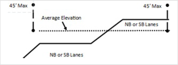
- The most adjacent travelled way of any other state-owned street within 100 feet from the base of the sign.
- The average elevation of the most adjacent travelled way of Mountain View Corridor (NB and SB lanes) located within 100 feet from the base of the sign.
- Each sign may have two display faces with an active display area not to exceed 500 square feet each, and an inactive (static) display area not to exceed 700 square feet. However, in no event shall the total sign area (active plus inactive) exceed 800 square feet.
- Each sign face shall be oriented towards the travelled way of the adjacent state-owned street and away from any residential dwellings.
- The sign, including the supporting structure, shall be architecturally consistent with surrounding development and shall include decorative material such as stone, brick, decorative steel, or similar materials. In no case is an exposed support pole permitted.
- No sign shall extend closer than five feet to the edge of the right-of-way property line, nor impede a required easement.
- In addition to the information required for a building permit as described in subsection (F)(1) of this section, and the requirements as set forth in HCC chapter 10-27, an application for a multi-tenant center sign shall satisfy the requirements described below:
- A site plan depicting the location of the proposed sign on the subject property, a rendering of the sign calling out materials and sign dimensions, and any fencing or other screening to segregate the sign area from adjoining uses;
- A photometric plan for the sign along with a statement from the electronic display manufacturer certifying that each display will allow for automatic dimming based on nighttime and daytime and ambient light conditions based on industry best practices; and
- An acknowledgement from the sign owner that the sign will be operated in accordance with HCC 10-27-11.
M-1 Zone
Awning
25% of wall area may be covered
50% of awning may have sign copyCannot extend above building wall
8 feet maximum projection from building
May be on 3 building wallsAttached to building
8 feet minimum above ground
Primary sign copy on face or street side of structureBalloon
None
None
Anywhere on lot
A balloon sign is a conditional use
Flat or wall
20% of wall area
None
Building wall
Monument
32 sq. ft., plus 1 sq. ft. for every 4 feet of frontage over 30 feet on a street up to 64 sq. ft.
6 feet
18 feet setback
1 sign per 300 feet frontage, or part thereofA monument sign is a conditional use
Planned center
200 sq. ft.
16 feet above sidewalk grade
2 feet setback
A planned center sign is a conditional use. It is limited to commercial centers with 3 or more acres and multiple retail tenants
Maximum of 1 sign per street frontage
Subject to conditional use approvalRoof
Same as ground sign
10 feet above roof
Roof sign may be substituted for a ground or projecting sign, but is subject to conditional use approval. The planning commission may deny a sign or set more restrictive conditions. Signs shall be installed so that the support structure is not visible
Temporary
None
None
Allowed a maximum of 21 days at any one time, with a minimum 30-day separation between displays, and not more than 4 times during a calendar year
Window
None
None
In window
None
- A multi-tenant center sign shall be a conditional use and shall conform to applicable requirements of HCC chapter 10-27. An application for a permitted sign shall first obtain planning approval from the planning commission confirming compliance with each of the following requirements in advance of applying for a building permit:
(Code 2023, §§ 10-15G-1--10-15G-6; Ord. No. 2022-31, exh. A, 7-13-2022)