
Indian Trail City Zoning Code
DIVISION 1100
SUBDIVISION REGULATIONS
Chapter 1130 Fire Protection
Fire hydrants shall be installed according to the fire code adopted by the Union County Fire Service and fire hydrant improvements and locations shall be installed consistent with the following:
Chapter 1140 Flood Damage Reduction And Stormwater Management
All subdivision shall comply with Chapter 1360 and Chapter 1370 of the Unified Development Ordinance.
Chapter 1150 Sedimentation Pollution Control
In order to prevent soil erosion and sedimentation pollution of waterways, the applicant shall comply with all requirements of the North Carolina Pollution Control Act. A plan shall be submitted and approved by North Carolina Department of Environmental and Natural Resources and a copy of the plan and DENR permit shall be provided to the Town prior to Zoning Certificate permit issuance.
O210209-347
397
410
02-22-2022-371
1110.010 Authority
This Chapter is hereby adopted under the authority and provisions of the General Statutes of North Carolina (Chapter 160D, Article 8, Subdivision Regulation). The purpose of this Chapter is to establish procedures and standards for the development and subdivision of real property within the corporate limits of the Town of Indian Trail in an effort to ensure proper legal description, identification, monumentation, and recordation of real property boundaries.
1110.020 Purpose And Objectives
This Chapter is intended to promote the orderly layout and appropriate use of the land and to:
- Provide safe, convenient, and economic circulation of vehicular traffic;
- Provide suitable building sites which are readily accessible to emergency vehicles;
- Assure the proper installation of streets and utilities;
- Promote the eventual elimination of unsafe or unsanitary conditions arising from undue concentration of population;
- Conserve and protect the physical and economic resources of the Town of Indian Trail.
1110.030 Applicability
- These regulations shall govern all subdivisions of land within the corporate limits of the Town of Indian Trail as now or hereafter established. Subdivision means all divisions of a tract or parcel of land into two or more lots, building sites, or other divisions for the purpose of sale or any type of development whether development is immediate or in the future. The definition of subdivision includes residential and non-residential developments with multiple building sites and multi-site projects even if there is no division of the underlying land into separate parcels and also includes all division of land involving the dedication of a new street or a change in existing streets. All subdivisions, as defined, must be recorded with the Union County Register of Deeds.
- After December 31, 2008, each individual subdivision of land within the Town of Indian Trail's corporate limits shall comply with the requirements specified in this ordinance before any plat can be recorded or lots sold.
- All plats for the subdivision of land must conform to the requirements of this section and must be submitted in accordance with the procedures and specifications established in Chapter 360, Subdivisions. Land or parcels described by metes and bounds in an instrument of transfer or other document used for selling or transferring land are not exempt from compliance with this chapter. No utility shall be extended nor any permit be issued by an administrative agent of the Town of Indian Trail or Union County for the construction of any building or other improvement upon any land for which a plat is required until the requirements of this chapter have been met and the final plat approved.
1110.040 Exemptions
The following will not be subject to the regulations of this Chapter:
- The combination or recombination of portions of previously subdivided and recorded lots where the total number of lots is not increased and the resultant lots are equal to or exceed the standards of the Town of Indian Trail as shown in its subdivision regulations;
- The division of land into parcels greater than 10 acres where no street right-of-way dedication is involved;
- The public acquisition by purchase of strips of land for the widening or opening of streets; and
- The division of a tract in single ownership whose entire area is not greater than two (2) acres into not more than three (3) lots, where no street right-of-way dedication is involved and where the resultant lots are equal to or exceed the standards of the Town of Indian Trail as shown in this ordinance.
1110.050 Development Names
The subdivision name shall not duplicate or closely approximate the name of an existing subdivision within or within the general vicinity of Indian Trail. The following shall also apply:
- Proposed subdivisions or developments may have the same or similar name if they are an extension of an existing subdivision or development with the same or similar name.
- Development names must be reviewed by the Town and submitted to Union County Emergency Services for official approval. Additional fees may be assessed for any change in development names.
- Residential subdivisions shall have a monument sign with the development’s name at each vehicle access point. Refer to Section 9160.040 for the Table of Sign Requirements.
1110.060 Applicable Policies
Subdivisions must be designed and laid out in accordance with:
- Zoning and Other Laws All subdivisions and lots created under this Ordinance must comply with all relevant sections of the Indian Trail Unified Development Ordinance and all other local, State and Federal laws.
- Town of Indian Trail Comprehensive Plan When a proposed subdivision embraces any part of a proposed thoroughfare, school, park, or recreation site, or other public facility that has been designated in the officially adopted plan of the Town, that planned facility will be platted and designated by the applicant in the location shown on the plan. All reservations or dedications of land consistent with the Comprehensive Plan must be recorded with the Union County Register of Deeds.
- Land Development Standards All site improvements shall be done in accordance with standards established by the Town of Indian Trail. All subdivisions will comply with the Town of Indian Trail Land Development Standards (ITLDS). Plans for all infrastructure improvements shall be approved prior to the commencement of any site work.
- Traffic Movement and Pedestrian Circulation
- Subdivisions should be designed to create an integrated system of lots, streets, trails, and infrastructure that provides for efficient movement of people, bicycles and automobiles within the subdivision and to and from adjacent development.
- Subdivisions should provide for the efficient movement of through traffic by providing a completely interconnected hierarchy of streets and roads in order to avoid isolation of residential areas and over-reliance on federal, state and county roads.
- All subdivisions should be designed to provide safe and attractive pedestrian routes to nearby commercial centers, as well as nearby public/civic, employment and recreation uses. Pedestrian improvements to publicly accessible buildings will comply with the requirements of the Americans with Disabilities Act (ADA).
- Street layouts should be uncomplicated, so that emergency services, public services, and visitors can find their way to their intended destinations.
- Appearance
- Lot and street designs should be designed to avoid extended distances of back yard frontage on major roads. When that cannot be avoided, back yards abutting major streets should be buffered with uniform landscaping, fences and/or walls consistent with the perimeter landscaping requirements of Section 810.180.
- Subdivision perimeter areas should include adequate landscaping and buffering to protect future residents of the subdivision and adjacent developments from adverse impacts caused by significant differences in use, development intensity, or building height consistent with the perimeter landscaping requirements of Section 810.180.
- Open Space
- Open spaces should be integrated into and throughout subdivisions, should be connected with one another and with open spaces in adjacent developments, and should include trails that connect to pedestrian routes in the subdivision and to regional trail systems.
- Open spaces anticipated for use as active or developed parks should be accessible with at least minimum of 50 feet of frontage on a street and all active parks should be located on relatively flat, well-drained terrain.
- Open spaces not anticipated for use as active or developed parks should be located on prominent high points with significant views, or along significant and interesting geological features or wooded areas or along significant drainages.
- Open spaces that are anticipated to serve as trail corridors should be continuous with anticipated trail corridors on adjacent properties.
- Open spaces that are intended for use as a trail or public park shall be consistent will all adopted Town Plans.
- Natural Hazards Lands subject to flooding, excessive erosion, and subsidence because of soil types or groups, water courses and other drainageways, steep slopes, or other natural hazards may not be platted for residential or other uses in such a way as to present a danger to life or property, or to the public health, safety, or general welfare.
- Natural and Cultural Resources
- Subdivisions should be designed in a manner that creates the least damage to the natural environment, avoids to the maximum extent feasible, significant natural resources such as woodlands, wetlands, water bodies, steep slopes, and rock outcroppings. Subdivisions should be designed to preserve trees and native vegetation, ponds, streams, rivers, lakes, hillsides and other natural resources that exist on a site.
- Subdivisions should be designed to preserve cultural and historic resources.
- Property Owners Associations
- Property owner associations are required for all subdivisions that include land or improvements owned in common.
- If a property owners association is assigned responsibility for the maintenance and control of streets, open space, recreational facilities, or other common areas and facilities within a subdivision, that association must have legal authority to maintain and exercise control over the common areas and facilities, including the power to compel contributions from residents or property owners to cover their proportionate share of the costs associated with the maintenance of the common areas and facilities.
1110.070 Installation Of Permanent Reference Points
Monuments must be installed in accordance with Standards of Practice for Land Surveying in North Carolina, as adopted by the North Carolina State Board of Registration for Professional Engineers and Land Surveyors and such monuments must be placed in all subdivisions.
1110.080 Lots
The size, shape, and orientation of lots must be appropriate for the location of the proposed subdivision and for the type of development contemplated. All lots must comply with the standards of this section, except as expressly provided in this ordinance.
- Compliance with Other Regulations Every lot must have sufficient area, dimensions, and street access to permit the construction of a principal building in compliance with all applicable requirements of this ordinance.
- Minimum Building Area Every lot must have a contiguous buildable area of a shape sufficient to hold a principal building that is at least 40% of the lot’s total area or 3,000 square feet, whichever is less. This contiguous buildable area must lie at an elevation at least two (2) feet above the 100-year flood elevation.
- Lot Depth-to-Width Ratio Lots may not have a depth greater than four (4) times their width (at the required front setback).
- Side Lot Line Configuration Side lines of lots should be at or near right angles or radial to street lines.
- Lot Lines and Drainage Lot boundaries must coincide with existing (natural and constructed) drainageways to the extent practicable. This provision is intended to avoid the creation of lots that can be built upon only by altering drainageways.
- Lots on Thoroughfares Major subdivisions may not be approved that permit individual residential lots to access major thoroughfares or boulevards.
- Access Requirements All lots must have public street access and frontage meeting the requirements of the subject zoning district, except as expressly stated in this section. Lots and dwelling units located in cluster developments and planned developments with property owners’ associations may have in which permanent access and frontage on approved private streets, private driveways and/or private drives. The development as a whole must have public street access and frontage in accordance with the standards of the subject zoning district.
- Flag Lots
- Flag lots are prohibited, provided that the Technical Review Committee may recommend the creation of flag lots when they determine that a flag lot is necessary to allow reasonable use and benefit of the subject parcel or to alleviate situations that would otherwise cause undue hardship. Flag lots may be allowed only in the following instances:
- When necessary to eliminate access onto thoroughfares;
- When necessary to make reasonable use of irregularly shaped parcels;
- When necessary to make reasonable use of parcels with severe topography or other physical constraints;
- When necessary to provide greater protection of natural resources areas (e.g., streams);
- When necessary to provide suitable land area and soil for location and operation of utilities.
- Flag lots are prohibited, provided that the Technical Review Committee may recommend the creation of flag lots when they determine that a flag lot is necessary to allow reasonable use and benefit of the subject parcel or to alleviate situations that would otherwise cause undue hardship. Flag lots may be allowed only in the following instances:
1110.090 Street And Sidewalk Improvements
- Basic Requirements All internal streets within a subdivision and any street upon which any lot within a proposed subdivision abuts or has its required frontage (other than a street maintained by the Town or State) shall be graded and paved by the developer in accordance with NCDOT, Division of Highways’ standards, or the Town of Indian Trail Land Development Standard (ITLDS), for paved streets. Curb, gutter, and sidewalk are required on all existing and new road segments abutting the subdivision except as provided in Section 1110.090Q.3. All associated storm drainage is to be contained within the street right-of-way or easement and shall be in accordance with NCDOT standards or the Town of Indian Trail Storm Water Manual, whichever is most restrictive. Sidewalks shall be required on both sides of all streets and shall be in accordance with ITLDS, the Indian Trail Pedestrian Plan, and NCDOT standards.
- Coordination and Continuation of Streets
The proposed street system shall be designed to provide a network of interconnected streets so as to facilitate the most advantageous development of the entire neighboring area. Access to adjacent properties may be gained by extending proposed streets to the property line, dedication to the boundary of such property and a temporary turnaround must be provided until streets on adjacent properties are built. The proposed street system must extend existing streets on their proper projections. Cul-de-sacs may not be used to avoid connection with an existing street or to avoid future extension. Cul-de-sacs and other permanently dead-end streets are permitted where one or more of the following conditions offer no practical alternative for connectivity:
- Significant topographical changes.
- Limiting environmental conditions.
- Restrictions or limitations on property accessibility.
- Conflicts due to land use relationships.
- Access to Subdivision Lots Every major subdivision with more than 50 lots and/or building units must have at least two (2) entrances, 200 lots or more shall have at least three (3), to the subdivision that afford reasonable means of ingress and egress for emergency vehicles as well as for all residents/visitors who need or desire access to the subdivision. These two entrances shall be on different roads wherever feasible. Regardless of the number of lots, entrances shall not be gated or otherwise restricted to public access.
- Private Streets
- Private streets may be platted subject to conditional zoning approval and only associated with the following development types in the following below:
- Business and/or industrial parks
- Private streets allowed pursuant to Section 1190.090 (D1) above may be platted in a subdivision with guarantees and/or surety as required by this section and only after the issuance of a Zoning Permit for the subdivision. A construction bond in the amount of the cost of construction plus 25% must be posted, and can be reduced to 10% once construction is complete and the road has passed the inspections from the Town. The reduced surety will be held in the form of a maintenance surety for a period of three (3) years to allow the infrastructure to go through several freeze-thaw cycles. In order to release the surety, the Town will conduct another inspection and request any repairs needed. The surety will be released once all repairs are made.
- Private streets may be platted subject to conditional zoning approval and only associated with the following development types in the following below:
- Marginal Access Streets Where a tract of land to be subdivided adjoins a major thoroughfare, the applicant may be required to provide a marginal access street parallel to the major thoroughfare or reverse frontage on a local street for the lots to be developed adjacent to the major thoroughfare. Where reverse frontage is established, private driveways may not be designed to have direct access to the major or minor thoroughfare.
- Street Names Proposed streets that are in alignment (as determined by the Planning Director) with existing streets shall be given the same name. In assigning new names, duplication of existing names must be avoided and in no case can the proposed name be phonetically similar to existing names irrespective of the use of a suffix such as street, road, drive, place, court, etc. Street names shall be subject to the approval of the Town and Union County Emergency Services.
- Right-of-Way Widths and Dedication Minimum street right-of-way widths are based on roadway classification and the design and improvement of all streets must comply with the Town of Indian Trail Comprehensive Plan and ITLDS. Roadway dedication may be required to comply with said documents and shall be measured for dedication purposes based on distance from the official centerline of the existing right-of-way. Said dedication shall be clearly noted on preliminary and final plats.
- Pavement Design Pavement widths and thicknesses shall be in accordance with the standards of the North Carolina Department of Transportation and the Town ITLDS, whichever is more restrictive, for the type of street. Alternatively, a licensed geotechnical engineer may submit a recommended design to the Planning Director for consideration in the review of a particular project.
- Grades
- Street grades shall be not more than 8% or less than 0.5%.
- Grades approaching intersections shall not exceed 5% for a distance of not less than 100 feet from the centerline of the intersection.
- The mainline street cross-slope shall be carried out a distance of at least 10 feet into the side street. Low points with catch basins shall be at least 10 feet from the end of the radius. A vertical curve may be necessary to transition to side street grade.
- Horizontal Alignment The roadway alignment shall preserve the natural features such as woodlands, creeks, and floodplains to the maximum extent practicable. All horizontal curves shall have such length as necessary to provide safe sight distance as outlined in the AASHTO Policy on Geometric Design of Highways and Streets, current edition.
- Vertical Curves All vertical curves shall have such length as necessary to provide safe sight distance as outlined in the AASHTO Policy on Geometric Design of Highways and Streets, current edition.
- Intersections
- Streets must be laid out so as to intersect as nearly as possible at right angles, and under extreme circumstances at a minimum of 75 degrees. No proposed street may intersect any other street at an angle less than 75 degrees.
- Property lines at street intersections shall be round with a minimum radius of 20 feet. Where a street intersects a highway, the design standards of the North Carolina Department of Transportation, Division of Highways will apply.
- Offset intersections are to be avoided unless an exception is granted. Intersections that cannot be aligned should be separated by a minimum length of 200 feet between street center lines.
- Intersections with collectors must be 500 feet from another intersection on the same side.
- Intersections with major or minor thoroughfares should be at least 1,000 feet apart measured from centerline to centerline.
- Intersections that are to be signalized shall be no closer than 2,500 feet or the location must comply with the standards of the North Carolina Department of Transportation, Division of Highways, whichever is more restrictive.
- Dead-End Streets
- Streets shall be designed to provide interconnectivity. Permanent dead-end streets must end in a cul-de-sac turnaround, and are allowed if the following conditions occur in a manner that prohibits connecting to an adjacent street:
- Significant topography limitations.
- Limiting environmental conditions.
- Odd parcel sizes or shapes.
- Limited accessibility to the property.
- Conflicting land use relationships.
- Street designs such as loop streets or closes are preferred to the use of traditional cul-de-sac designs. These alternatives help support the turning movements of emergency and service vehicles.
Figure 1100-1: Alternative to Cul-de-sac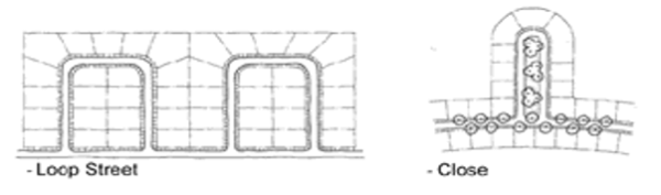
- Streets shall be designed to provide interconnectivity. Permanent dead-end streets must end in a cul-de-sac turnaround, and are allowed if the following conditions occur in a manner that prohibits connecting to an adjacent street:
- Temporary Turnarounds
- The Technical Review Committee may recommend a temporary turnaround (either a standard bulb cul-de-sac or T-turnaround) to be provided at the end of any stub street over 150 feet length or serving more than four (4) lots. Temporary turnarounds must comply with the following:
- The turnaround must be constructed in a temporary easement, located either on-site or off-site;
- The developer of the adjacent property making a road connection to the existing stub road is responsible for the removal of the turnaround and for the restoration of the area at the time that the road connection is made; and
- The turnaround must comply with all applicable cul-de-sac standards, including the Town ITLDS.
- Any plat containing a stub street must include the following note: “The street system shown on this plat includes one or more stub streets that are intended to be connected to the adjacent property at such time that the property is developed. The interconnection of neighborhoods with a street network ensures the efficient flow and dispersal of traffic and provides for additional points of ingress and egress for emergency vehicles.”
- In addition, a sign must be posted on the stub street right-of-way indicating that it is intended as a “Future Street Extension.”
- The Technical Review Committee may recommend a temporary turnaround (either a standard bulb cul-de-sac or T-turnaround) to be provided at the end of any stub street over 150 feet length or serving more than four (4) lots. Temporary turnarounds must comply with the following:
- Alleys
Alleys shall be allowed where approved as part of a subdivision or planned development. The following requirements shall apply to any single-family attached or detached development as indicated:
- Single-family attached or detached residential units with rear-loaded vehicular alley access may face onto a designated maintained open space with a minimum width of fifteen (15) feet in addition to the front setback.
- Primary pedestrian access into the building shall be from a public street frontage line, sidewalk, or parking area.
- If one home fronts onto a common open space and an adjacent home of the same type (attached or detached) is on the opposite side, the adjacent home shall also front onto the open space and have rear-loaded vehicular alley access.
- Lots front-loaded with vehicle access shall not face across a street onto the rear of lots, unless an intervening landscape buffer of 25 feet, per Chapter 810 Buffer Yards, Parking Lots and Street Frontages, is planted along the street block.
- Alleys shall be required for single-family attached townhouse developments with lots having 30-foot wide or less frontage width.
- Dwelling parking spaces in the alleys shall have a minimum of 3 feet between neighboring concrete dwelling parking spaces – a minimum of 1.5 feet divided between each townhome unit owner.
- Attached single-family uses abutting detached single-family uses shall provide a 25-foot landscaped buffer, per Chapter 810 Buffer Yards, Parking Lots and Street Frontages, along the length of the shared frontage, unless the attached units orient their front facades toward the detached homes with rear-loaded vehicle access from an alley.
- The standards of construction of alleys will be per the ITLDS and NCDOT requirements.
- Single-family attached or detached residential units with rear-loaded vehicular alley access may face onto a designated maintained open space with a minimum width of fifteen (15) feet in addition to the front setback.
- Street Design to Prevent Congestion and Promote Traffic Calming
- The street design shall have multiple connections, (existing and future), to disperse traffic impacts and reduce speeding.
- Modifications of street geometry, intersection design, and other traffic calming measures are acceptable when necessary to discourage high volume, high speed through traffic.
- Where feasible, all new development shall provide more than one access for ingress and egress at the time of development.
- Limitations or restrictions on cut-through traffic will not apply when a street is designated as a thoroughfare on the Town’s Comprehensive Plan or is designated as the collector street on the adopted major collector street map.
- Curb, Gutter and Sidewalk
- Street rights-of-way are designed and developed to carry motor vehicle traffic and allow some on-street parking; to provide a safe and convenient passageway for pedestrian and bicycle traffic; and to serve as an important link in the Town’s drainage systems.
- All streets within a new subdivision (residential or commercial) shall be constructed with curb and gutter in accordance with the ITLDS and NC DOT.
- Concrete sidewalks shall be installed along both sides of the street within a new residential or commercial subdivision. Refer to the Indian Trail Pedestrian Plan for recommended pedestrian connections. A sidewalk may be allowed on only one (1) side of the street if:
- The street services fewer than five (5) dwellings units, or
- The street serves single-family detached residences where the lots (at least 90%) are four (4) acres or more in size, or
- The Town Council determines that, given the likely use of the sidewalk, its cost is utterly disproportionate to its value to the public as may be the case in low density developments or in environmentally sensitive areas such as the Goose Creek Village area.
- The sidewalks required by this section shall be constructed according to the specifications set forth in the ITLDS and Comprehensive Plan. The Town Council may consider the installation of walkways constructed with other suitable materials when it concludes that such walkways would serve the residents of the development as adequately as concrete sidewalks; and where such walkways would be more environmentally desirable or more in keeping with the overall design of the development.
- The Planning Director, Planning and Zoning Board, or Town Council may require pedestrian crosswalk improvements when blocks exceed 600 feet in width or whenever deemed necessary to provide safe and adequate pedestrian circulation or access to schools, playgrounds, shopping areas, or community facilities.
- Any development located along public or private streets must provide curb, gutter and sidewalks along its street frontage in accordance with the Town of Indian Trail Comprehensive Plan, ITLDS, and this section.
- Development along the Highway 74 Corridor must provide sidewalk ten (10) feet in width and curb and gutter as required by the Indian Trail Comprehensive Plan and all other applicable ordinance.
- Responsibility for maintenance of sidewalk must be documented and recorded prior to final plat approval, as per Section 1170.050A. In most cases responsibility would be that of the homeowners association (HOA) or developer.
- Street Name Signs Street name signs must be installed by the developer at each street intersection as appropriate to identify all street names and located as shown in the ITLDS. Street name signs, poles and brackets shall be of a type approved by NCDOT for installations on state maintained streets. All street name signs, poles, and brackets must be installed prior to the issuance of a certificate of occupancy permit for any home adjacent to the street.
- Traffic Control Devices Traffic control devices such as stop, yield and speed limit signs (but not including electric or electronic traffic signals) shall be installed on public streets by the developer at the appropriate locations as determined by NCDOT and the Manual of Uniform Traffic Control Devices (MUTCD). Installation standards and materials shall be in conformance with NCDOT standards for such devices.
- Storm Drainage Not Contained in Street Rights-of-Way All storm drainage facilities that are not situated in a street right-of-way shall be constructed for and maintained by the homeowners association (HOA) or developer in a manner consistent with the Town of Indian Trail stormwater management manual.
- Street Lights
- Street lights shall be provided in all new subdivisions. Lighting fixtures shall be of a common theme, decorative cutoff type, and shall comply with the lighting standards for public and private roadways as established in Lighting Standards (see Chapter 1330) of this Unified Development Ordinance. Fixtures shall be mounted on a free-standing non-wood pole, approved by the Town. The poles and fixtures shall be painted black unless otherwise approved by the Planning and Zoning Board.
- Lighting layout for the entire subdivision must be submitted to the Town for approval, even if the subdivision is being built in phases. The lighting layout shall be consistent with the Lighting Standards Section of this UDO and the standards provided in the “Roadway Lighting Handbook,” U.S. Department of Transportation, Federal Highway Administration 1978, as revised.
- A layout plan shall be submitted to the Town for approval and must include a foot-candle grid with the average, minimum/maximum, and uniformity calculations and all planned light improvement must comply with the Lighting Standards of this Unified Development Ordinance.
Amended by Ord. O210209-347 on 2/8/2021
Amended by Ord. 397 on 3/26/2024
Amended by Ord. 410 on 12/10/2024
1120.010 General Requirements
Any subdivision which has either public water or public sewer system or both legally available or to be made available within 300 feet of its boundary shall have such available systems extended by the developer to provide service to each lot in the subdivision. Water and sewer installations shall be in accordance with the standards of the Union County Public Works Department.
1120.020
Where water and/or sewer is not made available to each lot a certificate shall appear on the final plat from the Union County Health Department indicating the appropriateness of the lots to support whatever alternate systems are to be permitted.
1120.030
Electrical, television, and telephone utility lines installed within subdivisions must be underground unless the Technical Review Committee determines that underground installation is unreasonable of infeasible. The Town must not require a developer or builder to bury existing above ground power lines located outside the boundaries of the parcel of land considered for subdivision pursuant to G.S. 160D-804; S.L. 2019-174.
1120.040
Utility easements with a width acceptable to public and private utility providers must be provided to accommodate electric, telephone, gas, and community antenna television services; conduits; and sewer or water lines. The location of such easements must be reviewed and approved by the Town, with advice from utility providers, before final plat approval.
1120.050
Utility easements must be kept free and clear of any buildings or other improvements that would interfere with the proper maintenance or replacement of utilities. The city is not liable for damages to any improvement located within the utility easement area.
1130.010 General Requirements
Every development (subdivided or unsubdivided) that is served by a public water system shall include a system of fire hydrants sufficient to provide adequate fire protection for the buildings located or intended to be located within such development.
1130.020
Fire hydrants must be located in accordance with the rules and regulations identified in North Carolina Fire Prevention Code. Appeals of these codes shall be filed with the North Carolina Building Code Council and the North Carolina Department of Insurance.
1130.030
The Planning Staff and Union County Fire Service shall review all fire hydrant locations and fire hydrant specifications. A letter shall be provided from the Union County Fire Marshal’s Office to the Town stating the proposed development is in compliance with said Code. Final approval of locations and specifications shall be by the permit issuing authority.
1130.040
Water lines that serve hydrants shall be at least six (6) inch lines, and, unless no other practicable alternative is available, no such lines shall be dead-end lines.
1130.050
The permit issuing authority may modify any previously issued permit to bring that project into compliance based on the Fire Marshal’s certification that said project is in compliance with the North Carolina Fire Prevention Code.
1160.010 Dedication Of Land
- Every applicant who proposes a subdivision of land for residential purposes shall dedicate a portion of land or pay a fee in lieu thereof, in accordance with this Chapter, for public park, greenway, recreation, and open space sites to serve the recreational needs of the residents of the subdivision or development. In the case of active recreation facilities (ball parks, soccer fields, bike paths) and passive facilities such as greenways and trails, the Planning Director will require that an easement be recorded assuring public access to these facilities in perpetuity.
- At least 1/35 of an acre shall be dedicated for each dwelling unit planned or proposed in the subdivision plat or development. To the extent feasible, areas with environmentally limitations (e.g. designated flood plain areas, wetlands, and areas with a slope in excess of 15%) should be dedicated as open space and the Town may require these areas to be dedicated in excess of the minimum standard provided in this Section provided that reasonable economic use of the property is permitted. Designated wetland areas must be identified and reserved on the plat of subdivision and such areas must be posted with warning signs designed to prevent any future alteration or damage to these natural areas.
- Except as otherwise required by the Town Council or Planning Director at the time of preliminary plat approval, all dedications of land shall meet the following criteria:
- Unity The dedicated land shall form a single parcel of land, except where the permit authorizing authority determines that two (2) or more parcels would be in the best interest of the public, for example, two (2) or more parcels may be acceptable where a subdivision covers a large area or where a site includes two (2) or more environmentally sensitive areas. In such cases, the Town may require that such parcels be connected by a dedicated strip of land at least 30 feet in width for the purpose of connecting the parcels via trails, bikeways, and greenways.
- Usability Two-thirds of the dedicated land shall be useable for active recreation. Furthermore, only 50% of lakes and streams may be included in computing any of the dedicated land area excluding stormwater detention facilities. Land dedicated only for greenways need not follow the requirements of this subsection for improved recreation space. In the case of a Planned Development, dedicated open space may be used for other public projects such as schools, libraries, and civic centers that serve the needs of the community.
- Shape The shape of the portion of the dedicated land which is deemed suitable for active recreation shall be sufficiently square or round to be usable for any or all recreational facilities and activities such as athletic fields and tennis courts, when a sufficient amount of land is required to be dedicated. Land dedicated only for greenways need not follow the requirements of this subsection.
- Location The dedicated land shall be centrally located so as to reasonably serve the recreation and open space needs of residents of the subdivision.
- Access Public access to the dedicated land will be provided either by adjoining public street frontage or by a dedicated public easement, at least 30 feet wide, which connects the dedicated land to a public street or right-of-way. Side-slope grades adjacent to existing and proposed streets will allow for reasonable access to the dedicated land. Where the dedicated land is located adjacent to a street, the developer or applicant will remain responsible for the installation of utilities, sidewalks, and other improvements required along that street segment. Public access or dedicated walkways to greenway dedications must be at least 20 feet wide. After the property is dedicated and improved consistent with the requirements of this Section, the Town of Indian Trail or a homeowners association (HOA) will assume responsibility for maintaining any sidewalks and other improvements adjacent to the street used for access to the open space.
- Topography The average slope of the portion of dedicated land deemed usable for active recreation will not exceed the average slope of the entire subdivision to be developed. In no case shall a slope on the usable portion of dedicated land exceed 15%.
- Landscaping Dedicated parks, recreation, and open space areas will have a sufficient natural or manmade buffer or screen to minimize any negative impacts on adjacent residents.
1160.020 Payments Of Fees In Lieu Of Land Dedication
- The payment of fees, in lieu of the dedication of land under Section 1160.010 above, may occur at the request of the applicant or developer. However, the decision to require the dedication of land for recreational purposes, or a payment of a fee in lieu, will be made by the Town Council (for Conditional Zoning Districts) after having received a recommendation from the Planning and Zoning Board and the Town’s Parks, Arts, Recreating and Culture Advisory Committee and having evaluated the proposed dedication and the relationship such dedication would have with the Town’s overall recreational needs.
- The Planning and Zoning Board may recommend approval, denial or approval with conditions of a preliminary plat based on the required open space dedication of this Section. Preference will be given to projects that provide open space on-site in the form of a land dedication. The final decision to either accept land for recreational purposes or to accept a fee in lieu of land will be the jurisdiction of the Town Council.
- The fees in lieu of dedication shall be paid prior to final plat approval.
- The amount of the payment shall be the product of:
- The number of acres to be dedicated, as required by Section 1160.010B above;
- The assessed value for property tax purposes of the land being subdivided, adjusted to reflect its current fair market value at the time such payment is due to be paid.
- Procedures for determining the amount is as follows:
- An appraisal of the land in the development shall be performed by a professional land appraiser selected by the developer from an approved list maintained by the Town. The appraisal shall not be done prior to submission of the preliminary plat but must be completed prior to the final plat approval. The cost of the appraisal shall be borne by the developer.
- Professional land appraiser refers to a land appraiser who, in the opinion of the Town, has the expertise and/or certification to perform an adequate appraisal.
- Procedures for determining the amount is as follows:
1160.030 Procedures
- At the time of filing a preliminary plat, the applicant shall designate thereon the area or areas to be dedicated pursuant to Section 1160.010A. If the applicant desires to make a payment in lieu of the dedication of land, a letter to that effect shall be submitted with the preliminary plat. All payments in lieu of dedication will be deposited in the Town’s “Parkland Capital Improvements Account” to be used for park, greenway, trail, or other open space or recreational improvements in the vicinity of the development paying the fees. The Town Council reserves the right to refuse to accept dedication of parcels for a public park, recreation area, or open space but the Town Council must specify the basis for such refusal. In the case of a refusal, the applicant will have the opportunity to modify the proposed dedication or fee-in-lieu or seek review of the decision in a court of competent jurisdiction.
- Where a dedication of land is required, such dedication shall be shown on the final plat when submitted, and such plat shall be accompanied by an executed general warranty deed conveying the dedicated land to the Town. Where a payment in lieu of dedication is approved by the Town, such payment will be made before the final plat is signed and recorded.
1160.040 Authority To Sell
The Town Council shall have the authority to sell land dedicated pursuant to Section 1160.010. The proceeds of such sale shall be used for the acquisition and/or development of other recreation, park or open space sites, greenways, or for sidewalk development serving the subdivision or more than one subdivision in the immediate area.
1160.050 Provisions Of Equivalent Facilities Under Neighborhood Or Community Home Owners Association
The Town encourages neighborhood or homeowner associations or management to construct, operate, and maintain private parks and recreation. The construction, operation, or maintenance of such private facilities shall not, however, diminish or eliminate the responsibility and obligations of the applicant under Section 1170.050A, et seq.
1160.060 Greenways
Greenways may be credited toward the requirements of Section 1160.010 provided that such greenways are part of the Town’s Comprehensive Pedestrian Plan and dedicated to public use. An easement will be recorded for any greenway and such easement will provide for public access for pedestrians, bicyclists, and others expected to make use of this open space.
1170.010 Agreement And Security Required
- In lieu of requiring the completion, installation and dedication of all improvements within the subdivision prior to plat approval, the Town of Indian Trail may enter into an agreement with the applicant whereby the applicant shall agree to complete all required improvements in the subdivision. Alternatively, such agreement can call for the completion of improvements for only a portion (i.e. phase) of the subdivision.
- Once said agreement is signed by both parties and the security required herein is provided, the final plat, or portion thereof, may be approved, if all other requirements of this Ordinance are met. To secure this agreement, the applicant shall provide to the Town Council, either one, or a combination of the forms of guarantees described in Sections 1170.010C and 1170.030.
- The following items shall be required to be included within the performance bond or surety calculation for both developed and undeveloped lots: curb, gutter, sidewalk, pavements, seeding, and stabilization, landscaping within the right-of-way, stormwater features for residential subdivisions, and community storm water features for commercial subdivisions, in accordance with other sections of this ordinance and the Post Construction Ordinance. Additionally, other required improvements within the subdivision will be required to be guaranteed in accordance with the Town ordinances. The applicant must provide an itemized cost estimate for the cost of the construction to the Town. The Town of Indian Trail’s engineering staff and any consultants must validate the estimated costs. The owner shall provide information sufficient for the Town of Indian Trail’s engineering staff and consultants to make a determination as to the appropriateness of the security amount. If less than 50% of the work is complete, a surety of 125% of the remaining construction improvements will be held by the Town in the form of a performance surety. If more than 50% of the work is complete, the Town will hold two (2) sureties: (1) A performance surety of 125% of the cost of the improvements which have not been completed at the time. (2) A maintenance surety for 1/3 of the cost of all of the improvements for the final plat. Sidewalk and right-of-way seeding may be placed in a separate surety in the amount of 125% of the construction cost estimate. This surety cannot be held for longer than two (2) years. If the surety/bond described herein is not provided, the Town of Indian Trail may not issue Zoning Permits to any affected properties within the subdivision.
1170.020 Performance Guarantees (Surety Bonds)
- The applicant shall obtain one or more performance guarantee(s) for the proposed improvements, including any associated stormwater infrastructure, for the project. The amount shall not exceed one hundred twenty-five percent (125%) of the reasonably estimated cost of completion at the time the performance guarantee is issued, and/or at the time of any extension of the performance guarantee is granted. A performance guarantee shall be in any of the following forms:
- Surety bond issued by any company authorized to do business in the state of North Carolina.
- Letter of credit issued by any financial institution licensed to do business in the state of North Carolina; or
- Cash surety in the form of a certified check in the exact approved amount.
- Performance guarantees shall only be used for the completion of any improvements and not for repairs or maintenance after completion.
- The duration of any performance guarantee(s) shall be until such time as the improvements are accepted by the Town. Any performance guarantee shall be returned or released, as appropriate, in accordance with section 1170.050, "Reduction and Release of Guarantee Security of this ordinance, and G.S. 160D-804, (g).
- If improvements are not complete and the current performance bond is expiring, the performance guarantee shall be extended, or a new performance guarantee issued, for an additional period until such required improvements are complete. A developer shall demonstrate reasonable, good faith progress toward completion of the required improvements that are the subject of the performance guarantee or any extension. The form of any extension shall remain at the election of the developer.
- If improvements are not complete and the current performance bond is expiring, the performance guarantee shall be extended, or a new performance guarantee issued, for an additional period until such required improvements are complete. A developer shall demonstrate reasonable, good faith progress toward completion of the required improvements that are the subject of the performance guarantee or any extension. The form of any extension shall remain at the election of the developer.
1170.030 Cash Or Equivalent Security
The applicant shall deposit cash, an irrevocable letter of credit, or other instrument readily convertible into cash at face value, either with the Town or in escrow with a financial institution designated as an official depository of the Town of Indian Trail. Checks provided for security will only be accepted in the form of a certified check. If cash or other instrument is deposited in escrow with a financial institution as herein provided, the applicant shall then file with the Town an agreement between and the financial institution and himself guaranteeing the following:
- That said escrow account shall be held in trust until released by the Town and may not be used or pledged by the applicant in any other matter during the term of the escrow; and
- That in case of a failure on the part of the applicant to complete said improvements, the financial institution shall, upon notification by the Town submission of the Engineer's estimate of the amount needed to complete the improvements by the Town to the financial institution immediately either pay to the Town the funds estimated to complete the improvements, up to the full balance of the escrow account, or deliver to the Town any other instruments fully endorsed to pay for the full amount of the improvements.
1170.040 Default
Upon default, meaning failure on the part of the applicant to complete the required improvements in a timely manner as spelled out in the performance bond or escrow agreement, then the surety, or the financial institution, holding the escrow account, shall, if requested by the Town, pay all or any portion of the bond or escrow fund to the Town of Indian Trail up to the amount needed to complete the improvements based on the Engineer's estimate. Upon payment, the Townin its discretion, may expend such portion of said funds as it deems necessary to complete all or any portion of the required improvements. The Town shall return to the bonding firm any funds not spent in completing the improvements. Should the amount of funds needed to complete the installation of all required improvements exceed the amount in the bond or escrow account, the applicant shall nonetheless be responsible for providing the funds to cover such costs. The applicant shall at all times bear the financial burden for the installation of all required improvements.
1170.050 Reduction And Release Of Guarantee Security
The Permit issuing authority is authorized to release or reduce any security posted as the improvements are completed and approved consistent with this Section. The release of any security will be consistent with the following procedures:
- A surety reduction on an existing or future Town-maintained roadway can be granted as long as the applicant can show proof that over 75% of the required improvements have been completed in a satisfactory manner. If the improvements are along a NCDOT-maintained roadway, then the applicant would have to follow NCDOT Division 10's bond process.
- If there are other required improvement bonds (landscaping, trails, etc.) that the applicant would like to be reduced by the Town, he or she can submit a request and approval will be determined by the Engineering Director.
- The surety release process on an existing Town-maintained roadway will begin once the applicant submits for a Town inspection. Once the inspection is completed and a report is issued, the applicant will receive a list of repairs that need to be corrected. After repairs are completed to the Town's satisfaction then a release will be issued. For future Town-maintained streets, the applicant must follow the process as outlined in the adopted Street Acceptance Policy for the Town of Indian Trail. For NCDOT-maintained roadways, the applicant must follow NCDOT Division 10's bond process.
- For Private Roads, please see the following. For a one-time reduction, the applicant shall show proof that over 75% of the required improvements have been completed in a satisfactory manner.
- For the release of a surety for a private road: (1) The Town will hold an inspection and provide a repair list as needed; and (2) Once roads pass inspection, the sureties will be released.
- Other Improvements: In order for the Town to release the bond for improvements other than streets, the applicant must verify the construction is complete. In the case of a stormwater feature, the applicant must submit as-built calculations and an as-built survey. This must be completed in accordance with all other applicable Town regulations.
1170.060 Legal Provisions
- Procedure for Plat Approval
- After the effective date of this Ordinance, no subdivision plat of land within the Town's jurisdiction shall be filed or recorded until it has been submitted to and approved by the Town and appropriate agencies, and until this approval is entered in writing on the face of the plat by the Chairman or head of that agency.
- A plat shall not be filed or recorded by the Union County Register of Deeds of any subdivision located within the Town's jurisdiction that has not been approved in accordance with this Ordinance, nor shall the Clerk of Superior Court order or direct the recording of a plat if the recording would be in conflict with the requirements of this Ordinance.
- Effect of Plat Approval on Dedications Pursuant to General Statute 160D-806, the approval of a plat shall not be deemed to constitute or affect the acceptance by the Town of the dedication of any street or other ground, public utility line, or other public facility shown on the plat. However, the Indian Trail Town Council may, by resolution, accept any dedication made to the public of lands or facilities for streets, parks, public utility lines, or other public purposes, when the lands or facilities are located within its corporate limits.
- Penalties for Violation After the effective date of this Ordinance, any person who, being the owner or agent of the owner of any land located within the territorial jurisdiction of this Ordinance, thereafter subdivides his land in violation of this Ordinance or transfers or sells land by reference to, exhibition of, or any other use of a plat showing a subdivision of the land before the plat has been properly approved under the terms of this Ordinance and recorded in the Office of the Register of Deeds of Union County, shall be subject to the penalties set forth in Chapter 1520, Section 1520.060 "Penalties". The descriptions by metes and bounds in the instrument of transfer or other document used in the process of selling or transferring land shall not exempt the transaction from this penalty. The Town of Indian Trail, through its attorney or other official designated by the Town may enjoin illegal subdivision, transfer, or sale of land by action for injunction.
- Variances Where, because of severe topographical or other conditions peculiar to the site, strict adherence to the provisions of this Ordinance would cause an unnecessary hardship, the Planning and Zoning Board through a quasi-judicial proceeding may authorize minor adjustments to the terms of this Ordinance only to the extent that is absolutely necessary and not to an extent which would violate the intent of the Ordinance. See Chapter 380 Appeals and Variances for appeal requirements.
- Abrogation It is not intended that this Ordinance repeal, abrogate, annul, impair, or interfere with any existing easements, covenants, deed restrictions, agreements, rules, regulations, or permits previously adopted or issued pursuant to law. However, where this Ordinance imposes greater restrictions, the provisions of this Ordinance shall govern.
Amended by Ord. O210209-347 on 2/8/2021
Amended by Ord. 02-22-2022-371 on 2/22/2022
Amended by Ord. 410 on 12/10/2024