
Indian Trail City Zoning Code
DIVISION 300
DEVELOPMENT REVIEW PROCEDURES
O210209-347
397
410
423
310.010 Hearing Procedures
- Required Hearings
Public hearings are held by Town Council and the Planning and Zoning Board convening as a quasi-judicial proceeding to officially render a decision on some applications. A public hearing will be required for the following applications to appear before the following approval bodies:
Table 300-1: Required Hearings by Application TypeApplication for Approval Planning and
Zoning BoardTown Council Official Map Amendment X Text Amendment X Appeal of Administrative Decision X Preliminary Plan Approval, Major Subdivision
(if associated with Conditional Zoning District)X Variance X Conditional Zoning District X Annexation X Development Agreement X Note: No Public Hearings held by Planning and Zoning Board when convened
for non-quasi-judicial proceedings. - Summary of Notice Required
Notice will be required for development review as shown in the Table below.
Table 300-2: Notice Requirements by Procedure TypeProcedure Published Posted Mailed Official Map Amendment (ZM) X X X Text Amendment (ZT) X Appeal of Administrative Decision X X Preliminary Plat Approval, Major Subdivision X X Conditional Zoning District (CZ) X X X Community Meeting (part of CZ process) X X X Variance, Major Subdivision X X X Annexation X* X* X* Development Agreement** X X X * Annexation to be advertised with ZM or CZ.
** See Chapter 390 Development Agreements for details. - Required Notice for Public Hearings
- Public hearing notifications shall be in accordance with the table in Section 310.020.
- A notice for any public hearing on any public hearing (including the zoning map amendments) will be published once a week for two (2) successive weeks in a newspaper having general circulation in the county. The notice will be published for the first time not less than ten (10) days and not more than twenty-five (25) days before the date fixed for the hearing. With respect to major map amendments, notification of such changes will be in accordance with G.S. 160D-601.
- Mailed notice for all public hearings shall:
- Be sent by the Town by first class mail to the applicant, the owner of the subject parcel of land, and the owners of all parcels of land and established Home Owner Associations that lie within 500 feet as measured from the exterior boundaries of the subject property.
- Property owners shall be identified from the county tax listings and notice mailed to the last addresses listed for such owners on the county tax abstracts.
- The notice shall be mailed ten (10) days prior to the proposed public hearing in accordance with 310.050. The person or persons mailing such notices will certify to the decision making authority that fact, and such certificate will be deemed conclusive in the absence of fraud. With respect to major map amendments, notification of such changes will be in accordance with G.S. 160D-601.
- Rezoning petitions proposing to change the zoning classification from one land use category to another, intensifying the use (e.g. Residential to Commercial, Commercial to Industrial), shall require:
- A 500-foot public hearing mail notification area mailed and processed as set forth herein; and
- One community meeting to be held prior to the petition being scheduled for discussion by the Planning and Zoning Board. The community meeting shall be advertised by sign posting of the subject property and notice mailed to owners of all parcels of land and established Home Owners Associations that lie within 500-feet as measured from the exterior boundaries of the subject property in the same manner as Section 310.030.C.
- A 500-foot public hearing mail notification area mailed and processed as set forth herein; and
- Be sent by the Town by first class mail to the applicant, the owner of the subject parcel of land, and the owners of all parcels of land and established Home Owner Associations that lie within 500 feet as measured from the exterior boundaries of the subject property.
- Request for mailed notification of a public hearing by parties not identified in 310.030.C shall be honored if written request has been submitted to the Planning Department prior to the 10 (ten)-day notification deadline.
- The Planning staff will also post notices of the public hearing in the vicinity of the property that is subject to a public hearing and will take any other action deemed by the planning staff to be useful or appropriate to give notice of the public hearing on any proposed amendment.
- The newspaper and mailed notice required or authorized by this section will:
- State the date, time, and place of the public hearing;
- Summarize the nature and character of the proposed project associated with the public hearing;
- If a proposed amendment involves a change in zoning district classification, reasonably identify the property whose classification would be affected by the amendment;
- State that the full text of an amendment or copies of application forms can be obtained from the planning department; and
- State that substantial change in the proposed amendment may be made following the public hearing.
- State the date, time, and place of the public hearing;
- The required posted notices will indicate the following:
- Type of application filed;
- Link to the Town website, containing the information for the time, date and place of the public hearing, as well as all information on the application filed.
- A phone number to contact the Town.
- Note - such public notice sign postings shall be placed on the affected property(ies) once a complete project application (i.e., conditional zoning, zoning map amendment, etc.) is received by the Town.
- Type of application filed;
- For quasi-judicial procedure, a board may continue an evidentiary hearing that has been convened without further advertisement. If an evidentiary hearing is set for a given date and a quorum of the board is not then present, the hearing shall be continued until the next regular board meeting without further advertisement pursuant to G.S. 160D-406 (b).
- Public hearing notifications shall be in accordance with the table in Section 310.020.
- Constructive Notice
Minor defects in the notice will not impair the notice or invalidate proceedings pursuant to the notice if a bona fide attempt has been made to comply with applicable notice requirements. Failure of a party to receive written notice will not invalidate subsequent action. In all cases, however, the requirements for the timing of the notice and for specifying the time, date and place of a hearing and the location of the subject property will be strictly construed. If questions arise at the hearing regarding the adequacy of notice, the decision-making body will make a formal finding regarding whether there was substantial compliance with the notice requirements of this ordinance before proceeding with the hearing. - Computation of Time
Whenever the Planning Director or other person is required to take certain action (e.g., mailing or publishing a notice) on or before a specified number of days prior to the occurrence of an event (e.g., a public hearing), then in computing such period, the day of the event shall not be included but the day of the action shall be included. For example, if notice of a public hearing is required to be published at least ten (10) days before the hearing, then notice published on the first of the month would be satisfactory for a hearing on the eleventh. - Modification of Application at Public Hearing
The applicant may agree to modify his application, including the plans and specifications submitted, in response to questions or comments by persons appearing at the public hearing or to suggestions or recommendations by the Town Council or Planning and Zoning Board.- Unless such modifications are so substantial that the approving authority cannot reasonably be expected to perceive the nature and impact of the proposed changes without revised plans before it, the approving authority may approve the application with the stipulation that the permit will not be issued until plans reflecting the agreed upon changes are submitted to the Planning Department.
- Where deemed appropriate by the affected decision-making body, modifications may be referred back to the recommending body for review, prior to further consideration. The decision-making body will choose one of the following options:
- Continue the hearing to a new date and time certain within 45 days in accordance with the provisions of below; or
- Close the hearing and re-publish notice of any future hearing in accordance with this section.
- Continue the hearing to a new date and time certain within 45 days in accordance with the provisions of below; or
- Unless such modifications are so substantial that the approving authority cannot reasonably be expected to perceive the nature and impact of the proposed changes without revised plans before it, the approving authority may approve the application with the stipulation that the permit will not be issued until plans reflecting the agreed upon changes are submitted to the Planning Department.
- Continuation of Public Hearings
A public hearing may be continued without further notification, so long as the motion to continue such hearing, made in open session, specifies the date and time when the hearing will be continued. However the following limitations and conditions have been adopted to prevent problems created by last-minute and repeated requests for continuances.- If an applicant wishes to request a continuance, then the Planning Director must receive a request for continuance and the reasons for the request, in writing, or have such request received in the mail at the Town of Indian Trail Planning Department, addressed to the attention of the Planning Director no less than seven (7) business days prior to the scheduled hearing.
- Upon receipt of such a properly filed request for a continuance, the Planning Director will have the authority to continue the case to a regularly scheduled meeting if the applicant establishes to the satisfaction of the Planning Director that there is just cause for granting a continuance. If the Planning Director denies a continuance, then the applicant can request a continuance from the Planning and Zoning Board based on just cause, but the applicant must be prepared to have the appeal heard if either of the Boards denies the request. Three votes of the Planning and Zoning Board in a quasi-judicial proceeding are required in order to grant a continuance and four votes of the Planning and Zoning Board in non-quasi-judicial proceedings are required.
- If the applicant wishes to file a second request for a continuance, or any subsequent request for a continuance, then the applicant must properly comply with the same procedure as stated above. However, the Planning Director will have the authority to request sufficient information from the applicant either justifying or corroborating such a request for a continuance and the applicant is expected to provide the information to the Planning Director before the day of the scheduled hearing. The applicant or the applicant’s representative must appear before the Planning and Zoning Board at the scheduled hearing to request a continuance. The Planning Director will be given an opportunity to report on the information provided by the applicant to support the granting of the continuance and the Planning Director will have the right to make a recommendation on the request. A vote of the majority of the Planning and Zoning Board members is required in order to grant a continuance. The Board will not grant the continuance unless there are exceptional, extenuating reasons justifying a continuance that must be stated in the minutes. In appearing before the Planning and Zoning Board, the applicant must be fully prepared to have the case proceed if the request for continuance is denied.
- If an applicant fails to properly comply with the procedure described herein, then the case must be heard as scheduled. If the applicant fails to appear for the hearing or appears and does not elect to proceed, then the application will be automatically be deemed to be denied. The applicant will be entitled to file an entirely new application and pay a new filing fee, as if no application had been filed before. If the application is an appeal of a notice of violation, and the 30 days have transpired since the date of the notice of violation, then the 30 days will have expired and the Planning and Zoning Board will not have jurisdiction to hear an appeal on the notice of violation. While the Planning and Zoning Board will not have jurisdiction if the 30 days have expired on an appeal from a notice of violation, in all other circumstances, the Planning and Zoning Board does retain authority for some extraordinary situations to grant a continuance to hear the case. In order to grant a continuance to hear such a case, there must be a majority of the vote by the Planning and Zoning Board finding either:
- That there are highly unusual circumstances justifying the Board to grant the continuance, and
- That there is a most compelling reason of justice to so hear the case or the Planning Director recommends that a continuance should be granted in the best interest of an efficient and effective way of dealing with the issues raised by the case.
- That there are highly unusual circumstances justifying the Board to grant the continuance, and
- If an applicant wishes to request a continuance, then the Planning Director must receive a request for continuance and the reasons for the request, in writing, or have such request received in the mail at the Town of Indian Trail Planning Department, addressed to the attention of the Planning Director no less than seven (7) business days prior to the scheduled hearing.
- Special Requirements for Quasi-Judicial Hearings
A public hearing on a variance request or administrative appeal will be considered a quasi-judicial hearing and must follow statutory procedures (G.S. 160D-102 (28)).- Participation of Parties with Standing
Parties with standing must be allowed to participate in the evidentiary hearing including presenting evidence, cross-examining witnesses, objecting to evidence, and making legal arguments. A party shall be considered with standing if they possess the following criteria:- An ownership interest, a leasehold interest, or an interest created by easement, restriction, or covenant in the subject property;
- An option or contract to purchase the subject property;
- The applicant requesting the hearing; or
- Any other person who will suffer special damages as a result of the possible decision.
- An ownership interest, a leasehold interest, or an interest created by easement, restriction, or covenant in the subject property;
- Evidence
- All persons who intend to present evidence to the Board (rather than arguments only) will be sworn.
- All findings and conclusions relevant to the permit or appeal decision (crucial findings) will be based upon reliable evidence. The hearing must be evidentiary to gather competent, material, and substantial evidence (evidence admissible in a Court of Law). Competent evidence shall, regardless of the lack of a timely objection, not include the opinion testimony of lay witnesses as to any of the following pursuant to S.L.2019-11, § 1.9:
- The use of property in a particular way would affect the value of other property.
- The increase in vehicular traffic resulting from a proposed development would pose a danger to the public safety.
- Matters about which only expert testimony would generally be admissible under the rules of evidence.
- The use of property in a particular way would affect the value of other property.
- The board chair shall rule on any objections and the chair's rulings may be appealed to the full board.
- Record
- A tape recording or other audio record will be made of all public hearings required by Section 310.010 and such recordings will be kept for at least two (2) years. Accurate minutes will also be kept of all such proceedings, but a transcript need not be made.
- All documentary evidence presented at a hearing as well as all other types of physical evidence will be made a part of the record and will be kept by the Town for at least two (2) years, whenever practical.
- A tape recording or other audio record will be made of all public hearings required by Section 310.010 and such recordings will be kept for at least two (2) years. Accurate minutes will also be kept of all such proceedings, but a transcript need not be made.
- Written Decision
- The board shall determine contested facts and make its decision within a reasonable time. Every quasi-judicial decision shall be based upon competent, material and substantial evidence in the record.
- Each quasi-judicial decision shall be reduced to writing and reflect the board’s determination of contested facts and their application to the applicable standards.
- A quasi-judicial decision is effective upon filing the written decision with the clerk to the board or such other office or official as the ordinance specifies.
- The decision of the board shall be delivered by personal delivery, electronic mail or by first-class mail to the applicant, property owner and to any person who has submitted a written request for a coy, prior to the date the decision becomes effective. The person required to provide notice shall certify that proper notice has been made.
- The board shall determine contested facts and make its decision within a reasonable time. Every quasi-judicial decision shall be based upon competent, material and substantial evidence in the record.
- Judicial Review of Quasi-Judicial Final Decisions
- Every final decision of a quasi-judicial body (i.e., Planning and Zoning Board in a quasi-judicial proceeding) shall be subject to review by the Superior Court by proceedings in the form of certiorari pursuant to G.S. 160D-102 and 160D-1402.
- The petition for the review shall be filed with the Union County Clerk of Superior Court by the later of thirty (30) days after or later of the following occurrences:
- A written copy of the quasi-judicial body has been given in accordance with 310.080 (D);
- When first class mail is used to deliver notice, three days shall be added to the time to file the petition.
- A written copy of the quasi-judicial body has been given in accordance with 310.080 (D);
- A copy of the writ of certiorari shall be served upon the Town of Indian Trail.
- Participation of Parties with Standing
Amended by Ord. O210209-347 on 2/8/2021
Amended by Ord. 397 on 3/26/2024
Amended by Ord. 410 on 12/10/2024
Amended by Ord. 423 on 1/13/2026
310.020 Information Required For Sketch Plans, Preliminary Plans/Site Plans And Final Plats
The sketch plans, preliminary plans/site plans and final plats shall depict or contain the information indicated in the following table. An X indicates that the information is required. All plans shall be in black lines and generated PDF files.
Table 300-3: Submittal Requirements by Plan Type
| Submittal Items | Sketch Plan | Preliminary Plat & Site Plans | Final Plat |
| GENERAL ITEMS | |||
| Cover sheet with index | X | X | |
| Title block | X | X | X |
| Name of subdivision (if applicable) | X | X | X |
| Name and contact information of owner/applicant and any professional office working on plans | X | X | X |
| Registration seals from professionals | X | X | |
| Vicinity map | X | X | X |
| Graphic bar scale (each sheet if applicable) | X | X | |
| Dates of preparation and submittal | X | X | X |
| Revision table in title block | X | X | |
| EXISTING CONDITIONS | |||
| Boundary survey | X | X | |
| Existing easements | X | X | X |
| Existing property lines, buildings, water courses, railroads, bridges, culverts, storm drains, other structures on the property or immediately adjacent | X | X | X |
| Corporate or jurisdictional boundaries (as applicable) | X | X | X |
| Parcel information on adjacent properties (parcel no., owner(s), acres) | X | X | X |
| Exact boundaries of flood hazard, floodway, or flood fringe areas from the community's FEMA maps or other approved maps | X | X | X |
| Wooded areas, heritage trees, marshes, rock outcroppings, ponds, lakes, streams, streambeds, and natural features | X | X | |
| Location and descriptions of all monuments, markers, or control points | X | X | |
| Historical properties identified on the National Register of Historic Places | X | X | X |
| SITE DATA TABLE | |||
| Tax parcel number(s) | X | X | X |
| Existing/approved zoning | X | X | X |
| Proposed zoning | X | X | |
| Existing and proposed use(s) | X | X | |
| Required minimum setbacks | X | X | X |
| Acreage/SF: total property, total lot area, parks/recreation space, non-residential use, average lot area | X | X | X |
| Total lots and/or units | X | X | X |
| Required and provided parking spaces | X | X | |
| Disturbed area | X | X | |
| Impervious area | X | X | |
| Floor area | X | ||
| Building height | X | X | |
| Linear feet in streets | X | X | |
| SITE PLAN ELEMENTS | |||
| Notes as applicable | X | X | X |
| Proposed lot lines, lot and block numbers all with exact dimensions | X | X | X |
| Adjacent roads, right-of-way, internal access roads, and required number of road ingress/egress points | X | X | X |
| Parking layout and dimensions, sidewalk along property frontage, pedestrian connection to site, loading space, and sight triangles | X | X | X |
| Easements (existing and proposed), floodplain, streams, and applicable buffers | X | X | X |
| Phasing (if applicable) | X | X | X |
| Amenities such as paths, playgrounds, open space usable areas, and common open space | X | X | |
| Mail kiosks with required parking spaces | X | X | |
| Trash enclosure | X | ||
| Fencing and retaining walls | X | ||
| Lots numbered consecutively | X | X | |
| Address numbers | X | ||
| Pedestrian or bicycle paths | X | X | |
| School sites | X | ||
| Land to be dedicated to public use | X | X | X |
| Areas to be used for non-residential use | X | X | X |
| Designation of ownership for common open spaces and recreation facilities | X | X | |
| LANDSCAPING PLAN | |||
| Existing and required landscaping (DIVISION 800) such as buffering, tree save, shading and screening | X | ||
| Parking lot and perimeter requirements, dimension of planting islands | X | X | |
| Landscaping strips adjacent to building | X | X | |
| Plant table with symbol, name/species, count, size and spacing (Use only approved species on UDO lists) | X | ||
| Location of existing and proposed lighting poles | X | ||
| Existing tree inventory (if applicable) (option to be on Existing Conditions sheet) | X | ||
| Tree save plan | X | ||
| STREET PLANS | |||
| Proposed streets | X | X | X |
| Existing and platted (access easements) streets | X | X | |
| Off-site street improvements due to TIA requirements | X | X | |
| Conditional zoning off-site street improvements due to TIA requirements | X | ||
| Right-of-way location/dimensions | X | X | |
| Pavement widths/typical sections | X | X | X |
| Approximate grades | X | ||
| Engineering data for corners and curves | X | ||
| Typical street cross sections | X | ||
| Street names (to be approved by County) | X | X | |
| GRADING AND DRAINAGE PLAN | |||
| Existing utilities and drainage systems | X | ||
| Contours at 2-foot intervals | X | ||
| Easements for grading on adjacent properties (if applicable) | X | X | |
| Detention facilities including rain gardens | X | X | X |
| Coordinate with NCDEQ to ensure proper erosion control | X | ||
| Show tree protection zone (TPZ) | X | ||
| Show area of disturbance (Note: area of disturbance should not encroach on tree save or tree buffer areas.) | X | ||
| Designation of ownership for common stormwater facilities and maintenance responsibility | X | X | |
| UTILITY LAYOUTS | |||
| Sanitary sewers | X | ||
| Storm sewers | X | ||
| Other drainage facilities | X | ||
| Water distribution lines | X | ||
| Natural gas lines | X | ||
| Telephone lines | X | ||
| Electrical lines | X | ||
| Cable TV | X | ||
| Fiber optics/other communication | X | ||
| Utility easements | X | X | X |
| LIGHTING PLAN | |||
| Location of existing and proposed poles | X | ||
| Photometric plan: Footcandles (fc) for the entire site taken to the property line (max 2.0 fc if adjacent to commercial and 1.0 fc if adjacent to residential) (See Section 1330.050 General Lighting Standards for additional requirements.) | X | ||
| Pole and fixture type | X | ||
| TRUCK MANEUVERING* (if applicable) | |||
| Turning template for truck ingress/egress and type of truck used | X | ||
| ARCHITECTURAL ELEVATIONS | |||
| Building design of each facade including type of materials used, roof pitch, and overall dimensions of lengths and height | X | ||
| Include elevations for all buildings including garages, storage buildings, and trash enclosures | X | ||
| EIFS calculations if applicable | X | ||
| Digital (PDF file) copy of color renderings | X | ||
| RESPONSE LETTER | |||
| Document showing responses to recent Town review comments for each round of review | x | x | x |
Amended by Ord. O210209-347 on 2/8/2021
Amended by Ord. 397 on 3/26/2024
Amended by Ord. 423 on 1/13/2026
320.010 General Procedures
- Amendments to the text of this ordinance or to the zoning map may be made in accordance with the provisions of this Chapter.
- The term "major map amendment" will refer to an amendment initiated by the Town Council, Planning and Zoning Board, or planning staff that addresses a zoning reclassification action directly affecting more than 50 different property owners. In the case of a major map amendment, notification shall be provided per G.S. 160D-601.
- Amendments to the Town’s comprehensive plan may be made in accordance with this Chapter. The Town Council may consider amendments to the comprehensive plan not in association with a zoning map amendment with a recommendation from the Planning and Zoning Board. The Town Council may also consider amendments to the Comprehensive Plan when zoning map amendments are in significant conflict with the plan, as determined by the Planning Director. When required, an application for a comprehensive plan amendment must be submitted and reviewed concurrently with an application for a zoning map amendment. Otherwise, in the event of inconsistency with the Comprehensive Plan, the Comprehensive Plan will be automatically amended as part of the rezoning action in accordance with G.S. 160D-604 and 160D-605.
320.020 Initiation Of Amendments
An amendment to the text of this ordinance or to the zoning map or to the Town's comprehensive plan may be initiated by the Town Council, the Planning and Zoning Board, the planning staff, or any other interested person. If an amendment to the zoning map or the ordinance proposes to down-zone property, the request may only be initiated by the landowner(s) written consent or the Town pursuant to G.S. 160D-601 and S.L. 2019-111, Pt. I. A rezoning/zoning map amendment application must include:
- An application signed by the petitioner, who will indicate the capacity in which he/she filed the petition.
- In the event the party filing the petition is someone filing the same on behalf of the owner, such party must attach his authority to execute said petition on behalf of the owner to the petition.
- An application for rezoning must be accompanied by a survey and legal description of the property to be rezoned if the applicant is seeking to have rezoned less than an entire lot or tract or if the Planning Director determines that such information is otherwise necessary to provide sufficient public notice of the area requested for rezoning.
- Notice of the Planning and Zoning Board's consideration of a proposed minor map amendment must be sent to the owner of the property to be rezoned and to adjoining property owners as provided in subsection 310.030, C.
- Refer to Section 310.030 for refiling after a denial or withdrawl.
- Providing Actual Notice in Zoning Map Amendments. Except for a town-initiated zoning map amendment, when an application is filed to request a zoning map amendment and that application is not made by the owner of the parcel of land to which the amendment would apply, the applicant shall certify to the Town Council that the owner of the parcel of land as shown on the county tax listing has received actual notice of the proposed amendment and a copy of the notice of public hearing, as provided by NCGS 1A-1, Rule 4(J). If notice cannot with due diligence be achieved by personal delivery, registered or certified mail, or aby a designated delivery service authorized pursuant to 26 U.S.C. § 7502(f)(2), notice may be given by publication consistent with NCGS 1A-1, Rule 4(j1).
Amended by Ord. O210209-347 on 2/8/2021
Amended by Ord. 410 on 12/10/2024
Amended by Ord. 423 on 1/13/2026
320.030 Planning And Zoning Board Consideration Of Proposed Amendments
- Every proposed map or text amendment or amendment to the comprehensive plan will be referred to the Planning and Zoning Board for its consideration, comments and provide a written recommendation to Town Council regarding adoption of the proposal.
- The Planning and Zoning Board shall advise and provide written comment on whether the proposed action is consistent with the adopted Comprehensive Plan and any other officially adopted plan that is applicable pursuant to G.S. 160D-604 (d). A Planning and Zoning Board recommendation that a proposed amendment is inconsistent with the Comprehensive Plan shall not preclude consideration or approval of the proposed amendment by Town Council.
- The Planning and Zoning Board will endeavor to review the proposed amendment in such a timely fashion that any recommendations it may have can be presented to the Town Council at the public hearing on the amendment. However, if the Planning and Zoning Board is not prepared to make recommendations at the public hearing, it may request the Town Council to delay final action on the amendment until such time as the Planning and Zoning Board can present its recommendations.
- The Town Council may not take final action approving a proposed amendment until it has received the recommendation of the Planning and Zoning Board or until 45 days have passed since the proposal was heard by the Planning and Zoning Board, whichever occurs first. However, the Town Council is not bound by the recommendations, if any, of the Planning and Zoning Board.
320.040 Council Action On Amendments
- At the conclusion of the public hearing on a proposed amendment, the Council may proceed to vote on the proposed ordinance, refer it to a committee for further study, or take any other action consistent with its usual rules of procedure.
- The Council is not required to take final action on a proposed amendment within any specific period of time, but it should proceed as expeditiously as practicable on petitions for amendments.
- When adopting or rejecting a proposed amendment, Council shall approve a brief plan consistency statement describing whether its action is consistent or inconsistent with the Comprehensive Plan. The requirement for this statement may also be met by making a clear indication in the meeting minutes as depicted under G.S. 160D-605.
- In addition to the consistency statement, a brief statement of reasonableness shall be approved by Council when adopting or rejecting an amendment. The statement may consider, among other factors:
- Size, physical conditions, and other attributes of any area proposed to be rezoned;
- Benefits and detriments to the landowners, neighbors, and surrounding community;
- Relationship between the current actual and permissible development and the development permissible under the proposed amendment;
- Why the action taken is in the public interest; and
- Any changed conditions warranting the amendment.
- The required statement of reasonableness and the plan consistency statement may be approved as a single statement or separately pursuant to G.S. 160D-605 (c).
- If the amendment is adopted and the action was deemed inconsistent with the adopted plan, the zoning amendment shall have the effect of also amending any future land use map in the approved plan and not an additional request or application for a plan amendment shall be required pursuant to G.S. 160D-605 (a).
- A comprehensive plan or other applicable plan amendment may be considered concurrently with a zoning amendment pursuant to G.S. 160D-605 (a).
- Voting on amendments to this ordinance will proceed in the same manner as other ordinances.
320.050 Ultimate Issue Before Council On Amendments
In deciding whether to adopt a proposed text amendment to this ordinance, the central issue before the Council is whether the proposed amendment is consistent with the Town of Indian Trail’s Comprehensive Plan or any specific area plan and whether the proposed amendment advances, and/or protects the public health, safety or welfare. When considering a proposed map amendment, the Town Council will evaluate:
- The range of uses that may occur under the proposed amendment versus the range of uses that may occur under the existing zoning classification. The Council will not rely upon any representations made by the petitioner that, if the change is granted, the rezoned property will be used for only one of the possible range of uses permitted in the requested classification.
- The impact of the proposed change on the public at large versus any advantages or disadvantages to the individual requesting the change.
- The existing land uses and the zoning classifications of property within the general vicinity of the subject property.
- The suitability of the subject property for the uses permitted under the existing zoning classification.
- The extent that the amendment may adversely affect the operation of public facilities or services including roadways, storm water management facilities, sewer and water services, schools, and police and fire protection.
- Consistency with the Indian Trail Comprehensive Plan and small area plans if applicable.
- Whether the proposed amendment advances, and/or protects the public health, safety, or welfare.
330.010 Purpose And General Requirements
Conditional zoning districts provide for orderly and flexible development under the general policies of the base district without the constraints of the general district standards. Because Conditional Zoning district developments are constructed in a comprehensive manner, they establish their own building, street, block, and lot pattern which may be unique from other surrounding blocks or neighborhoods. Conditional zoning affords a degree of certainty in land use decisions not possible when rezoning to a general district, called conventional zoning or zoning map amendments. Additional standards and regulations may be attached to a proposed development to ensure compatibility with the surrounding uses and with applicable adopted plans in accordance with requirements of this section.
- Each planned development identified in Section 340.030 will have a corresponding conditional zoning district.
- Conditional zoning districts will be designated only in accordance with the procedures and requirements set forth in this chapter.
- No use will be permitted within a conditional district except pursuant to the conditions imposed on the conditional zoning districts approval. The permitted uses must be uses that this Ordinance allows in the corresponding general use district. Although, the conditional zoning may include the request to rezone the property in order to achieve the district needed for a proposed use.
- All standards and requirements that apply to the corresponding general use or planned district will apply to the conditional zoning districts.
- A property may be rezoned to a conditional zoning district only in response to and consistent with a petition submitted by the landowner, a lessee or person holding an option or contract to purchase or lease land, or an authorized agent of the landowner.
- A petition for conditional zoning must include a site plan and supporting information and text describing the project, specifying the intended uses of the property, and describing the rules, regulations, and conditions that in addition to the general district use conditions, will apply to the proposed development.
330.020 Application Procedures
All applications must include a conceptual plan, drawn to scale, and supporting text that, if approved, will become a part of the Ordinance amendment. The conceptual plan, drawn by an architect, landscape architect, professional surveyor, or engineer licensed to practice in North Carolina, shall include any supporting information and text that specifies the actual use or uses intended for the property and any rules, regulations, and conditions that are in addition to all Ordinance requirements, will govern the development and use of the property.
- The applicant shall, at a minimum, include as part of the application, each of the items listed below
- A boundary survey showing the total acreage, present zoning classifications, date, and north arrow.
- Legal description of the property(ies).
- The owners’ names, addresses, and the tax parcel numbers of all adjoining properties within five hundred (500) feet of the subject parcel. The information shall be provided in a digital format and typed on address labels.
- All existing or proposed easements, reservations, and rights-of-way on the property(ies) to be rezoned.
- Existing location of buildings on the parcel.
- Lot sizes for residential uses and proposed out parcels if applicable.
- Proposed principal uses: For residential uses this shall include the number of units and an outline of the area(s) where the structures will be located. For non-residential uses, designate the area(s) within the development where particular types of uses that will occur with reference made to the list of uses found in the applicable zoning district.
- Traffic impact analysis/study for the proposed service area as required by the Town’s Guide for the Preparation of Traffic Impact Studies document. In addition, traffic, parking, and circulation plans, showing the proposed locations and arrangement of parking spaces and access points to adjacent streets including typical parking space dimensions and locations (for all shared parking facilities) along with typical street cross-sections. The traffic impact analysis/study shall receive a preliminary approval by the Town prior to the community meeting being scheduled. The Engineering Director shall be authorized to require revisions to the preliminary approved TIA if it is determined that modifications to the proposed project (between the community meeting and public hearing) may result in other significant impacts.
- Detailed information on the number, height, size and location of structures.
- All proposed setbacks, buffers, screening and landscaping required by these regulations or otherwise proposed by the applicant shall be delineated on a conceptual plan. Actual approval of landscaping plans shall be part of the site plan review process.
- Generalized traffic, parking, and circulation plans.
- All existing and proposed points of access to public streets.
- A detailed description of all proposed phasing of development for the project.
- Number, location, type, and size of all signs proposed to be erected by the developer at entrances to the site. Additionally, a general description of other proposed signs including number, location, type and size of all commercial signs. Actual approval of signs shall be part of the site plan review process.
- Conceptual renderings of the proposed development delineating the exterior treatments of the principal structures including proposed materials and general architectural design shall be in compliance with the Statement of Integrity and Design. Actual approval of all proposed buildings shall be part of the site plan review process.
- Approximately identify all environment constraints on the subject property including but not limited to the following: flood plain, ponds, streams, and wetlands. Approximately delineate areas within the regulatory floodplain as shown on the official Flood Insurance Rate Maps (F.I.R.M.) published by the Federal Emergency Management Agency (F.E.M.A.).
- Existing and proposed topography at two-foot contour intervals or less.
- Scale and physical relationship of buildings relative to abutting properties. This may be accomplished by providing existing and proposed topographic elevation cross-sections of the site showing proposed structures relative to existing adjacent properties.
- Letter of water and sewer availability from Union County Public Works.
- Detailed information of measures that will be taken in order to comply with the Post Construction Ordinance. Prior to submitting an application for a conditional zoning district the applicant/property owner will need to have a consultation meeting with the Storm Water Administrator.
- School impact study for residential developments of fifty (50) lots/units or greater as required in UDO Chapter 13140.
- Conceptual Plans Conceptual plans, including all additional information shown on it, shall constitute part of the petition for rezoning to a conditional zoning district. No application shall be deemed complete unless the concept plans address all applicable minimum submittal requirements as outlined in Section 330.020,(A) and, accompanied by a digital PDF file copy of the application and fee in accordance with the fee schedule most recently adopted by the Town Council. The Planning Director may, on a case-by-case basis and within his/her sole discretion, specify if and how many paper copies of the conceptual plans the applicant must submit to initiate the review.
- Additional requirements When reviewing an application to rezone property to a conditional zoning district, the Planning and Zoning Board and/or Town Council may request additional information (in addition to that required in Section 330.020, as they deem necessary.
- Technical Review Committee The TRC shall review and comment on the proposed project to ensure all of the Town ordinances are being complied with. Once the TRC comments are addressed and the project is resubmitted the community meeting may be scheduled.
- Community Meeting
Once the conceptual plan and the required number of associated documents have been submitted to the Town and the required fees have been paid, the applicant shall schedule and hold a community meeting in coordination with the Town planning staff. Such meetings shall occur prior to the petition being scheduled on the Planning and Zoning Board agenda. The community meeting is designed to provide a framework for creating a shared vision with community involvement directed by the applicant in accordance with the following requirements:
- The applicant shall provide an agenda, schedule, location, and list of participants such as landscape architects, engineers, etc. to answer questions from citizens and service providers for the project in cooperation with the planning staff. This information shall be provided to the Town prior to the community meeting notification being mailed.
- The community meeting shall be a minimum of 4 hours. Two hours shall be scheduled during normal business hours to allow service providers (such as NCDOT, utilities, NCDENR) to participate as needed and to allow for citizens to drop in at a convenient time throughout the period. It is strongly recommended that this portion of the community meeting take place at the proposed development site. In addition, a 2 hour evening period shall be scheduled at the Indian Trail Town Hall or other nearby location agreed upon by the applicant and planning staff. This meeting shall also be conducted in a drop in format.
- Notice of community meetings shall at a minimum, be given as follows:
- A public notice shall be sent by the Town of Indian Trail to a newspaper having general circulation in the town not less than 10 days or more than 25 days prior to the date of the community meeting.
- A notice shall be sent by first class mail by the Town of Indian Trail to the property owner(s) affected by the proposed zoning change and to the owners of all properties that lie within 500 feet as measured from the exterior boundaries of the proposed development. The applicant shall furnish the Town with mailing labels that depict the names and addresses of the owners (or “Current Resident”) of all properties within said 500 foot area. Such notice shall be sent not less than 10 days prior to the date of the community meeting. The notification shall contain information regarding the community meeting time and location(s) as well as a general description of the proposal. The community meeting notice shall contain an information sheet with a general description of the conditional zoning process and timeline.
- A community meeting notification sign shall be posted by the Town in a conspicuous place at the property not less than 10 days prior to the community meeting.
- All conceptual plans submitted and reviewed during the community meeting process shall conform to all current Town Ordinances. In addition, a disclaimer statement shall be added to all community meeting notifications indicating that the proposed application and conceptual plan in no way has been endorsed or approved by the Town of Indian Trail.
- The applicant shall reimburse the Town for all expenses incurred to provide the notifications required by this Section.
- Town staff shall keep notes of citizen comments received during the community meeting. In addition, all service provider comments shall be recorded by the Town, including but not limited to, all correspondence, reports, and oral comments by service providers. After Town review, the information will be available at Town Hall and at subsequent meetings concerning the project. When practical, comments, ideas, and suggestions should be incorporated by the developer into the proposed development.
- Following the community meeting, the applicant shall have the opportunity to make changes to the application to take into account information and comments received. Revised copies of the conceptual plan in PDF file format shall be submitted to the Planning Director for review. No additional fee shall be required for making such changes provided the Planning Director receives the revised conceptual plan within 30 days following the community meeting. If a revised conceptual plan is not received within the 30 day period, or if the applicant otherwise notifies the Planning Director in writing that no revised conceptual plan will be submitted, the Planning Director shall review the original application submitted.
- Planning Director Review Within 30 days of the submission of a revised application or revised conceptual plan or within 60 days following the community meeting where no revised application is submitted, the Planning Director will make comments and suggestions for revisions. If the planning director does not forward comments to the applicant by the end of these time periods, the application shall be scheduled on the Planning and Zoning Board agenda. If the Planning Director provides the applicant with comments on the application, the applicant shall have 10 days after receiving those comments to inform the director whether the application will be further revised. If the applicant informs the Planning Director that the application will not be further revised, the director shall schedule the application on the Planning and Zoning Board agenda. If the applicant informs the director the application will be further revised, the director shall not submit the current application to the Planning and Zoning Board. Once the applicant submits a revised application, it shall be subject to review in accordance with this section.
Amended by Ord. O210209-347 on 2/8/2021
Amended by Ord. 397 on 3/26/2024
Amended by Ord. 410 on 12/10/2024
Amended by Ord. 423 on 1/13/2026
330.030 Planning And Zoning Board Review
- The Planning and Zoning Board will review the application for consistency with this ordinance and all adopted town plans.
- The Planning and Zoning Board will consider applications in a timely fashion and will forward a written recommendation to the Town Council for its consideration within the time frame authorized.
- In response to suggestions made by the Planning and Zoning Board, the applicant may revise the application before it is submitted to Council.
330.040 Town Council Decision
- Conditional zoning district decisions are a legislative process subject to judicial review using the same procedures and standards of review as apply to legislative general use district zoning decisions. Conditional zoning district decisions shall be made in consideration of the adopted Comprehensive Plan and other adopted land use policy documents and/or ordinances. A statement analyzing the reasonableness of the proposed rezoning shall be prepared for each application for a rezoning to a conditional district. Once the public hearing has been held, the Town Council shall take action on the petition. The Town Council shall have the authority to:
- Approve the application as submitted.
- Deny approval of the application.
- Approve the application with modifications that are agreed to by the applicant.
- Submit the application to the Planning and Zoning Board for further study. The Planning and Zoning Board shall have up to thirty (30) days from the date of such submission to make a report to the Town Council. Once the Planning and Zoning Board issues its report, or if no report is issued within that time period, the Town Council may take action on the application.
- The Council is not required to take final action on a proposed amendment within any specific timeframe, but it should proceed as expeditiously as practicable on applications for amendments.
- Voting on amendments to an associated ordinance of a previously approved conditional zoning will proceed in the same manner as a new conditional zoning application.
- Town Council’s Public Hearing The Town Council shall conduct a public hearing on the application. Notice of the public hearing shall be as provided in Section 310.030. Once the public hearing is conducted, the Town Council shall be in a position to take action on the rezoning. Staff reports regarding the application shall be furnished to the applicant, the Planning and Zoning Board and Town Council prior to the Planning and Zoning Board and Town Council taking action on the application.
- Conditions of Approval for Petition
- In approving a petition for the reclassification of a piece of property to a conditional zoning district (CZ), the Planning and Zoning Board may recommend, and the Town Council may request that reasonable and appropriate conditions be attached to approval of the petition.
- If no specific request is made by the petitioner to change the development standards, and/or permitted uses from the underlying zoning district, or if the petition is silent on the point, it shall be understood that the underlying zoning district guidelines and standards shall apply.
- The petitioner will have a reasonable opportunity to consider and respond to any development to approval or denial by the Town Council.
- Such conditions may exceed any performance criteria or minimum requirements listed elsewhere in this ordinance that apply to that development.
- Statements that (1) analyze whether the rezoning is consistent with an adopted comprehensive plan and any other officially adopted plan, and (2) other matters that the Town Council deems appropriate and (3) why it considers the action taken to be reasonable and in the public interest shall be prepared and accompany each final decision relative to the conditional zoning request.
- The Town Council may not impose any condition(s) that are not agreed to by the applicant. The Planning Director must obtain the applicant's written consent to conditions in the rezoning of a property to a conditional zoning district.
330.050 Effect Of Approval; Zoning Map Designation
If a petition for a conditional zoning district is approved, the development and use of the property shall be governed by the ordinance requirements applicable to the district’s zoning classification, the approved conceptual plan for the district, and any additional approved rules, regulations, and conditions, all of which shall constitute the zoning regulations for the approved district and are binding on the property as an amendment to these regulations and to the Zoning Map. Following the approval of the petition for a conditional zoning district, the subject property shall be identified on the Zoning Map by the appropriate district designation followed by the letters CZ. If a petition is approved, the Planning Director shall record with the Register of Deeds the approved conditional zoning district. The approved conditional zoning district attaches to and runs with the land.
- Changes to an Approved Conditional Zoning District
Except as provided in this section, a request to change the conceptual plan or the conditions governing an approved conditional zoning district shall be processed in accordance with this Ordinance as a new application to rezone property to a conditional zoning district. The Planning Director shall have the authority to approve an administrative amendment for minor modifications to an approved conditional zoning district conceptual plan or to the governing conditions without the requested change having to be approved as a new application in accordance with this ordinance. Such administrative amendments for minor modifications shall include only those changes that:
- Do not significantly alter the conceptual plan or its conditions;
- Do not significantly impact abutting properties and
- Do not increase the amount of residential development or the maximum number of allowed residential dwelling units.
- Any request for an administrative amendment shall be in writing, signed by the property owner, and it shall detail the requested change. The applicant must provide any additional information requested by the Planning Director. Accompanying the written request must be the applicable fee for administrative review that is required by the Town of Indian Trail fee schedule.
- Any decision by the Planning Director to approve or deny a request for an administrative amendment must be in writing and must state the grounds for approval or denial. The notice of this determination must be sent by personal delivery, electronic mail, or first-class mail to the property owner and the party seeking determination, if different from the owner. If the option for notification is in electronic format, the document should be in a file format with a PDF (Portable Document Format) extension as to protect the document from editing.
- The Planning Director shall always have the discretion to decline to exercise the authority delegated by this section if he or she is uncertain if the requested change would qualify as an administrative amendment or because the Planning Director determines that a public hearing and Town Council consideration is appropriate under the circumstances. If the Planning Director declines to exercise the authority delegated by this section, the applicant can only apply for a rezoning in accordance with this Chapter of this Ordinance.
- The administrative decision may be appealed to the Planning and Zoning Board in a quasi-judicial proceeding. An appeal may be filed within a 30-day period after the notice of determination. Town staff must presume that a notice sent by mail is received on the third (3rd) business day after the mailing.
- Revocation of Conditional Zoning District The purpose of this section is to put a time limit on the approval if the project does not move forward in a timely manner. The Town Council may act to revoke the conditional zoning district designation if the applicant fails to apply for the necessary building permits within two (2) years. The applicant may apply to the Town Council for approval to extend the two (2) year period, however, only one extension may be granted.
- Petition Withdrawal An applicant who has submitted a complete application for a conditional zoning district may withdraw the application prior to a final decision being rendered.
- Petition Resubmission Refer to Section 310.030 for refiling after a denial or withdrawal.
340.010 Process
- Petitions for annexation shall be processed in accordance with G.S. 160D.
- Public hearing notification may be advertised with the public notification for the concurrent Zoning Map Amendment or Conditional Zoning request.
- Acceptance of jurisdiction, adoption of development regulations, and decisions on development approvals may be made concurrently and may have a common effective date as provided by G.S. 160D-204. If the annexation is running concurrently with a rezoning or conditional zoning request, the decision for annexation must be made first before a decision is made on the development's zoning and/or conditions.
350.010 Purpose
The sketch plan review is an optional conceptual process allowing an exchange of information between the developer and the TRC. Sketch Plan Review is suggested prior to the submittal of the following development review procedures:
- Conditional Zonings
- Major Subdivisions Preliminary Plan
- By-Right Site Plan Reviews
This is not just an extra regulatory step but a point in the process that has the potential to save time and money on unnecessary revisions during further development of plans for rezoning or construction plan approval. It can also help to avoid denials from Town Staff and Town Council, where applicable. Note that a sketch plan review is also available for developers to get preliminary information about a concept they may or may not pursue for a prospective property. Note that even though sketch plan review also occurs in some processes with Union County, it does not necessarily mean that the two are best to occur concurrently. For example, if an applicant has not completed sketch plan review with the Town, early findings are known at times to find significant, site-altering issues that may severely affect a concurrent sketch plan submittal with Union County Water (and sewer) Department.
350.020 Process
- Plan Requirements
Sketch Plan suggested data requirements are provided in Table 300-3: Submittal Requirements by Plan Type. The plans should be drawn on the same size paper and scale as required for construction plans or, if applicable, final plats. - Application and Fee
An application and fee are required. The fee is credited when fees are paid for the next developmental procedure step (see applicable developmental review procedures below). Digital PDF files of the completed and signed application, and sketch plan shall be submitted to the Planning Department as the application package. - Review
The TRC and developer shall review the project to evaluate its feasibility in light of the Town's development practices and requirements. If the review results in a "Not Approved" decision, then the applicant may resubmit revised plans along with a response letter addressing all Town comments. If requirements cannot be met by the developer or the TRC does not allow certain requirements to be met conditionally, the review will be considered "denied". - Next After Review Conclusion
Once the review process has been completed and the sketch plan is conditionally approved, the developer may continue by either submitting an application package for a rezoning (conventional or conditional), if required, or complete the site construction plan package to submit for review.
350.030 Impact Of Approval
Sketch Plan Reviews may only receive a denial or conditional approval as a final staff determination. All approved sketch plans are automatically conditional as this is a Town input-only review requiring a primary approval under one of the development review procedures listed under 350.010 Purpose above. Review of the sketch design plan shall not in any way be construed as constituting an official action of approval for construction nor recording of the subdivision by the Town of Indian Trail.
350.010 Purpose And Intent
Planned development is a concept that is intended to encourage innovative land planning and site design concepts that achieve a high level of environmental sensitivity, aesthetics, high quality development, and other community goals by:
- Reducing or eliminating the inflexibility that sometimes results from strict application of zoning standards that were designed primarily for individual lots;
- Allowing greater freedom in selecting the means to provide access, open space and design amenities; and
- Promoting quality urban design and environmentally sensitive development by allowing development to take advantage of special site characteristics, locations and land uses.
350.020 Applicability
- The requirements of this Section and applicable requirements found in Division 600 will apply to all proposed Planned Development (PD). The PD is established as a conditional zoning district approved by the Town Council. These planned developments will be affixed to the Official Zoning Map only as CZ (Conditional Zoning) in accordance with the procedures in Chapter 330, "Conditional Zoning Districts", when an application for the respective development, meeting the requirements of this Section, is approved.
350.030 Submission Requirements
In order to qualify for a planned development zoning classification, a proposed development must first meet the following requirements:
- The proposed minimum standards for each type of Planned Development as follows:
Table 300-4: Planned Development Minimum Standards Section LocationPlanned Development Type Section Planned Unit Development Chapter 660 Traditional Neighborhood Development Chapter 670 Mixed Unit Development Chapter 680 Cluster or Open Space Subdivision Chapter 1210 - A pre-application conference will be required.
350.040 Approval Process
Approval of a planned development shall be in accordance with Chapter 330, "Conditional Zoning Districts", of this UDO.
350.050 Site/Development Plan
A suitable site/development plan will be submitted by the applicant for review by the Planning Director and the Planning and Zoning Board, and approval by the Town Council. Specifically, such plan will include the following elements, where applicable:
- Site Plan
The site plan (drawn to scale by a registered civil engineer, registered landscape architect, or registered architect) on sheet(s) no larger than 24 x 36 inches will include the following elements:
- the exact dimensions of the parcel of land under consideration including total acreage and current zoning classifications;
- zoning and current use classifications of adjacent properties and the identification of adjacent property owners;
- a schematic representation of general types and locations of land uses including parcel boundaries with acreage;
- the general density and intensity of the proposed uses including maximum gross density of the entire planned development and maximum and net densities of individuals parcels within the planned development;
- building setbacks for all parcels (both residential and nonresidential);
- proposed open spaces or parks and common open spaces with acreage delineations;
- storm drainage plan showing conceptual storm drainage system plan;
- utility plan showing conceptual water and wastewater system plan;
- phasing plan showing conceptual delineation of areas to constructed in phases or sections and the sequential order that will be followed in the development;
- hydrology plan showing streams, wetlands, floodplains, stream corridor buffers, proposed water bodies or impoundment areas.
- landscape concept plan;
- design guidelines for the development;
- vehicular and pedestrian circulation plan showing primary and secondary traffic circulation patterns with traffic volumes analysis, and all proposed sidewalk or greenways planned for the development; and
- any other information required by the Planning Director during the pre-application conference.
- Any information required by Section 330.020, "Application Procedures", under Chapter 330, "Conditional Zoning Districts".
350.060 Detailed Development Plan
Following the establishment of a planned development conditional zoning district and approval of the conceptual site plan, a detailed development plan must be reviewed and approved by the Planning Director in accordance with the procedures and requirements for the site plan process as set forth in Chapter 370 (Site Plan Review) and the following requirements:
- Detailed Development Plan Contents A detailed development plan must contain the same information required for a site plan or major subdivision plan, as set forth in Section 360.030.
- Subdivision Consistency Required The subdivision of lots will be consistent with the terms of the conditional zone.
350.070 Minor Changes To Detailed Development Plan
- The Planning Director is authorized to approve minor changes to a detailed development plan issued pursuant to this Section. Minor changes include those that have no substantial impact on neighboring properties, the general public, or those intended to occupy or use the proposed development. All other changes are major changes and can only be approved by the Town Council pursuant to the provisions applicable to the issuance of the original Planned Development Conditional Zoning District. Without limiting the generality of the foregoing, changes in phasing schedules are minor changes, while the following constitute major changes:
- any proposed increase in density, floor area, or impervious surface area limitations;
- any changes in uses authorized under the planned development conditional zone;
- substantial changes in pedestrian or vehicular access or circulation plans;
- substantial changes in stormwater drainage plans.
350.080 Development In A PD District
- Following approval of the detailed development plan, any lot that is subdivided may be developed in accordance with the provisions of the conditional zone and other applicable provisions of this UDO upon issuance of a certificate of zoning compliance.
- All further development must conform to the standards adopted for the district regardless of any changes in ownership. Any proposed changes in the district will be treated as amendments to this UDO and must be considered in accordance with procedures set forth in this Section for initial establishment of the district.
- In any event where it is determined by the Town Council that development in the Planned District is not in accordance with the standards adopted for that district, the Town Council will be empowered to amend the Official Zoning Map to place parts or all of the property in the Planned District in another zoning classification deemed by the Town Council to be more appropriate.
350.090 Performance Guarantee
Before approval of a Planned District, the Town Council may require a contract with safeguards satisfactory to the Town Attorney guaranteeing completion of the development plan in a period to be specified by the Council, but which period will not exceed five (5) years unless extended by the Town Council for due cause shown. Such guarantee may include the submission of a performance bond in an amount as set by the Town Council.
360.010 Major Subdivisions
Major subdivision review is a 4-stage review process. These steps will include:
- Stage 1: Sketch Plan Review
First is the preparation and submittal of an informal sketch plan and the review of this plan by the Technical Review Committee (TRC). The purpose of this informal process is not to approve any plans but to provide an opportunity to exchange information between the developer and the TRC. - Stage 2: Preliminary Plan Submittal
A plan must be submitted in accordance with specific development standards as listed in subsection 360.030F. Initially, the plan is reviewed by the TRC to determine whether or not it complies with the requirements of the UDO.- Conditional Major Subdivision
If the preliminary plan is associated with a proposed Conditional Zoning District, it will be forwarded to the Planning and Zoning Board for a recommendation to the Town Council. After reviewing the comments from the TRC and Planning and Zoning Board, the Town Council shall approve, approve conditionally, or disapprove the plan. Refer to Chapter 330 for Conditional Zoning District requirements. - Conventional Major Subdivision
If the preliminary plan request is not associated with a Conditional Zoning district request and is permitted by-right in the Table of Permitted Uses, the proposed subdivision plat will be processed as a conventional subdivision. If a rezoning is required, the process will follow the Conventional Zoning process in Chapter 320 for Zoning Map Amendments (ZM). The Planning Director will approve or disapprove the plan. When site construction plans are submitted, the development must meet all requirements in this UDO.
- Conditional Major Subdivision
- Stage 3: Site Construction Plans Review
After approval of the preliminary plan, the applicant may submit the construction drawings for review and approval by the Indian Trail Planning Department. Prior to any development, all construction plans shall be approved by the proper regulatory agencies. A zoning certification will be issued upon receipt of all required approvals and such certification will authorize the construction to proceed. - Stage 4: Final Plat and As-Built Drawing
Within 24 months of the preliminary plan approval by the Town Council or Planning Director, the applicant shall submit a final plat and an as-built drawing showing completion of the subdivision according to the preliminary plan and construction drawings. The final plat shall be reviewed by the TRC and approved by the Planning Department. Only after the final plat has been approved by the Planning and Engineering Departments, and recorded by the applicant at the Union County Register of Deeds office shall any of the lots be transferred or conveyed. The plat must be recorded within 30 days after approval by the governing body. A PDF file of the recorded plat and an electronic drawing version (AutoCAD – .dwg or .dxf) shall be submitted to the Indian Trail Planning Department for their records. - Minor Subdivisions
In the case of minor subdivisions, as defined in Section 360.140B, applications may be processed under an abbreviated review procedure. The minor subdivision plat shall be reviewed and approved by the Planning Department. The applicant, if in disagreement with the decision of the Planning Director, may appeal the Director’s decision to the Indian Trail Town Council.
Amended by Ord. O210209-347 on 2/8/2021
Amended by Ord. 397 on 3/26/2024
Amended by Ord. 410 on 12/10/2024
360.030 Preliminary Plan
Figure 300-1: Preliminary Plat (Major Subdivisions)
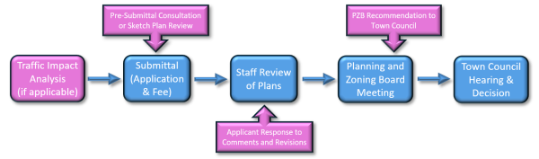
Preliminary plans may be referred to Town Council on appeal. Planning and Zoning Board review and recommendation as illustrated above is required for any subdivision approval that is part of an application for a conditional zoning district but is not required for conventional subdivision.
- Review Procedure
- If associated with a Conditional Zoning request, the applicant or authorized agent must submit PDF file copies of the preliminary plan to the Planning Department at least 21 days prior to a regular meeting of the Planning and Zoning Board. During this period, the TRC must evaluate the plan to determine whether or not it meets the requirements of this ordinance. The TRC may receive comments from other persons or agencies before making their final recommendations. After the TRC determines that the plan meets the requirements of this ordinance, it notifies the Planning Director that the Conditional Zoning Application may proceed in accordance with Section 330.020 D and ultimate consideration by the Town Council.
- If preliminary plan is associated with a Conventional Subdivision, the applicant or agent shall submit copies to the TRC for review and recommendation to the Planning Director.
- Number of Copies and Graphic Media Electronic PDF files of the proposed subdivision must be submitted as well as an electronic copy in an AutoCAD revision compatible with the Town’s CAD/GIS file projection.
- Scale and Size of Sheets The preliminary plan must be at a suitable scale to assure legibility and should be drawn on a sheet (s) with an outside dimension of not more than required by Union County Register of Deeds and shall include a 1-1/2” inch border on the left side and a 1/2” border on the remaining sides.
- Administrative Fees At the time of submission of the preliminary plan, the applicant must pay to the Town of Indian Trail a filing fee as established by the Town Council. In addition, the Town must be reimbursed by the applicant for all costs associated with the Town’s engineering and other related consulting services with respect to review of the preliminary plat prior to preliminary plat approval.
- TRC Submission to Director of Planning
The TRC shall evaluate the preliminary plan to determine whether or not it meets the requirements of this ordinance. After review by the TRC, the Planning Director shall approve, approve conditionally, or disapprove the preliminary plan for Conventional Subdivisions, or forward the recommendation of the TRC to the Planning and Zoning Board and Town Council if associated with a Conditional Zoning request. If approved or approved conditionally, the Planning Director or Town Council approval must be incorporated onto the drawings by the applicant and must provide the following:
- That the Indian Trail Planning Director or the Town Council approves or approves conditionally the subdivision. If approved conditionally, the specific conditions must be listed. Such approvals or conditional approvals must be signed and dated by the authorizing authority.
- Contents Required The preliminary plan shall depict or contain the information specified in Section 310.020 and Chapter 13140, unless previously submitted through a rezoning process. Plans not illustrating or containing the information required for Section 310.020 and Chapter 13140 shall be returned to the applicant or authorized agent for completion and resubmission.
- Disposition of Copies If the preliminary plan is approved or approved conditionally, approval and conditions must be noted on the plans and an electronic PDF file shall be sent to and retained by the Indian Trail Planning Department. If the preliminary plan is disapproved, the permitting authority shall specify the reasons for such action in writing. One copy of such reasons shall be returned to the applicant and one (1) copy retained by the Indian Trail Planning Department.
Amended by Ord. O210209-347 on 2/8/2021
Amended by Ord. 397 on 3/26/2024
Amended by Ord. 410 on 12/10/2024
360.040 Improvement Plans Approved Prior To Construction
All site improvements shall be in accordance with the Town of Indian Trail standards. Before a final plat is eligible for approval by the Planning Department, all improvements shall be installed and completed. All plans and specifications for site improvements, including but not limited to grading, drainage, sidewalks, utilities (water and sewer), and street improvements shall be inspected and approved by the proper agency prior to acceptance.
360.050 Final Plat Review
The Planning Director will approve all final plats provided that the final plat is consistent with the plat approved under the preliminary plat approval process. The final plat may include all or only a portion of the subdivision as proposed and approved on the preliminary subdivision plat, provided that all required improvements have been installed as called for in the approved preliminary plat or a surety bond or similar financial instrument has been approved by the Engineering Director in accordance with Chapter 1170, Improvement Guarantees for the subdivision.
Figure 300-2: Final Plat (Major and Minor Subdivisions)
- The Planning Director must determine whether or not the final plat substantially agrees with the approved preliminary plan. If substantial differences exist, the plat shall be resubmitted as a new preliminary plan. Prior to the approval of a final plat, the Planning Director will determine that:
- Any required sureties are in place;
- A letter of Public Works approval submitted;
- Any subdivision Code, Covenants, and Restrictions (CC&R’s) have been recorded.
- The Planning Director must approve or disapprove the final plat within 30 days after the Director has determined that a complete final plat application has been submitted.
360.060 Certifications Required From Applicant
Before the Planning Director accept a final plat, the following certifications shall appear on all copies of the final plat:
- Certificate of Ownership and Dedication
- The applicant must certify that they are the owner of the property shown and described, which is located in the Corporate Limits of the Town of Indian Trail and that the plan of subdivision establishes minimum building setback lines, and street dedications, walks, parks, and other sites and easements to public or private use as noted consistent with the requirements of this ordinance. Furthermore, the applicant must dedicate all sanitary sewer and water lines to the appropriate agency.
- All such certifications must be dated, signed, and notarized by a notary public.
- Certificate of Survey and Survey Accuracy
- The professional surveyor must certify as to the accuracy and detail of surveys of properties that are part of a subdivision and to the source of information for which the survey is based. The surveyor must certify that the survey map was prepared in accordance with G.S. 47-30 as amended.
- The surveyor must sign, seal, and date the survey and they must include their professional registration or license number.
- All signatures of professional surveyors must be witnessed by a notary public.
- Division of Highways District Engineer Certificate
- The District Engineer of the NC Division of Highways must certify that the streets on this plat designated as public are or will be in accordance with the minimum right-of-way and construction standards established by the Board of Transportation for acceptance on the state highway system.
- The District Engineer should further certify that the streets on the plat designated as private streets do not satisfy the minimum right-of-way and construction standards established by the Board of Transportation and that such streets will not be accepted on the state highway system.
- Certification NCDOT District Engineer and Town Engineering Director for Roads
- The District Engineer of the NC Division of Highways must certify that the streets on this plat designated as public are or will be in accordance with the minimum right-of-way and construction standards established by the Board of Transportation for acceptance on the state highway system.
- The Town Engineering Director should further certify that the streets on the plat designated as private streets have been designed to satisfy the minimum right-of-way and construction standards established by the Town of Indian Trail Land Development Standards for private streets. These streets will not be accepted on the Town roadway system the Town is not liable for the maintenance and repair of the streets.
- The Town Engineering Director for the Town of Indian Trail must certify that the streets on this plat are designated as public are or will be in accordance with the minimum right-of-way and construction standards established by the Town of Indian Trail in the Town Land Development Standards for acceptance on the Town roadway system.
- Certification by the Planning Director
- The Planning Director must certify that the final plat satisfies all the requirements of this Ordinance.
- The Planning Director must certify that all streets, utilities, and other required improvements shown on the plat have been installed or completed in a acceptable manner or that their installation or completion (within 24 months after the date below) has been assured by the posting of a performance bond or other sufficient surety, and that the subdivision shown on this plat is in all respects in compliance with the Town of Indian Trail specifications and standards, and the filing fee for this plat has been paid. The Planning Director will certify the approval of the final plat and such certification will be valid provided the plat is recorded with Union County Register of Deeds within 30 days.
360.070 Number Of Copies And Graphic Media
The final plat must be drawn on a sheet with an outside dimension of not more than required by Union County Register of Deeds and shall include a 1 1/2" border on the left side and a 1/2" border on the remaining sides. Once the review is approved, the final plat must be submitted as a Mylar for Town signatures before the applicant takes it to Union County for recording or as an electronic document to be signed and recorded electronically with Union County. If printed for signatures and recording, the Mylar must be three (3) ml., suitable for reproduction and each Mylar copy must have original signatures. The final plat shall be submitted electronically in an AutoCAD version compatible with the Town’s software and in a PDF file version of the recorded plat. All mapping requirements shall be in compliance with this Chapter, Union County Mapping Requirements, and N.C. G. S. 47-30.
Amended by Ord. O210209-347 on 2/8/2021
Amended by Ord. 397 on 3/26/2024
Amended by Ord. 423 on 1/13/2026
360.080 Plat Prepared By Licensed Surveyor
The final plat must be prepared by a surveyor licensed and registered to practice in the State of North Carolina. The final plat will substantially conform to the preliminary plat as it was approved. It must also conform to the provisions of plats, subdivisions, and mapping requirements as set forth in General Statutes 47-30, as amended, and the "Standards of Practice of Land Surveying in North Carolina".
360.090 Administrative Fees
At the time of submission of the final plat, the applicant or his authorized agent must pay the Town of Indian Trail a filing fee as established by the Indian Trail Town Council. In addition, the Town must be reimbursed by the applicant for all costs associated with the Town’s engineering and other related consulting services with respect to review of the final plat and inspection of infrastructure improvements prior to final plat approval.
360.100 Content Required
The final plat shall depict or contain the information specified in Section 310.020. Plats not illustrating or containing the information required in Section 310.020 shall be returned to the applicant or authorized agent for completion and resubmission.
360.110 Disposition Of Final Plats
Each final plat shall be signed and executed, as a Mylar copy or electronically, as required for recording by the Register of Deeds Office of Union County within 30 days after approval by the Planning Director. Contact the Register of Deeds Office for plat requirements. Electronically submit the final recorded plat in a PDF file format to the Indian Trail Planning Department.
Amended by Ord. O210209-347 on 2/8/2021
Amended by Ord. 397 on 3/26/2024
Amended by Ord. 423 on 1/13/2026
360.120 Resubdivision Procedures
For any replatting or resubdivision of land, the same procedures, rules, and regulations shall apply as prescribed herein for an original subdivision.
360.130 Minor Subdivisions, Lot Line Adjustments Or Lot Combinations/Recombinations
- Purpose An abbreviated process shall be permitted to simplify and speed up the review procedure for handling minor subdivisions, lot line adjustments, or lot recombinations without undermining the objectives of the subdivision regulations. Minor subdivisions and lot line adjustments must have the standard certifications to be signed by the Planning Director and the Engineering Director if applicable. Lot recombinations are typically not subject to approval or disapproval by the Town however, in order for the combination or recombination to be equal to or exceed the standards of the Town and requirements of this UDO, combination and recombination plats will be reviewed but not certified on the plat when approved. This process will ensure that all plats are consistent with this section so accurate records are maintained by Union County and the Town of Indian Trail.
- Minor Subdivision
A minor subdivision is a subdivision of land that does not involve any of the following:
- The tract or parcel to be divided is not exempted under Section 1110.040.
- No part of the tract or parcel to be divided has been divided under this subsection in the 10 years prior to division.
- The entire area of the tract or parcel to be divided is greater than five (5) acres.
- The creation of more than a total of five (5) lots since 1978.
- After division, all resultant lots comply with all of the following:
- All lot dimension size requirements of the applicable land-use regulations, if any.
- The use of the lots is in conformity with the applicable zoning requirements, if any.
- A permanent means of ingress and egress is recorded for each lot.
- All lot dimension size requirements of the applicable land-use regulations, if any.
- The creation of any new public streets or street right-of-ways;
- The extension of water and sewer system facilities operated by the Union County Public Works Department;
- The installation of drainage improvements through one (1) or more lots to serve one or more other lots;
- The installation of a private wastewater plant or a private water supply system for more than one lot or building site.
- The tract or parcel to be divided is not exempted under Section 1110.040.
- Lot Line Adjustment or Combination/Recombination
- A lot line adjustment is the relocation of an existing lot line or lines to a new location that does not result in:
- the creation of a new lot in addition to the existing lots;
- the modification of an existing lot to a new configuration that does not meet the minimum standards of this ordinance.
- A recombination or combination of portions of previously subdivided and recorded lots where the total number of lots is not increased and the resultant lots are equal to or exceed the standards of the municipality.
- A lot line adjustment is the relocation of an existing lot line or lines to a new location that does not result in:
- Procedure
- The developer shall submit a sketch development plan to the TRC. At this stage the TRC and the developer shall informally review the proposal.
- After this initial review has been completed, the applicant or authorized representative shall prepare a final plat as specified in Section 360.140E and submit it to the TRC.
- Before granting an approval, the TRC Chairman shall refer the application to the Union County Public Works or the Union County Environmental Health for a written approval as to the proposed water supply and sewage treatment systems as well as the other appropriate county departments and agencies for their review. All such agencies shall be given a reasonable period to submit their recommendations to the TRC Chairman.
- The TRC shall approve or disapprove the plat.
- If the applicant is denied, the chairman of the TRC shall promptly furnish the applicant with a written statement of the reasons for disapproval. If the applicant disagrees with the decision of the Planning Director the applicant may appeal to the Indian Trail Town Council at their next regular meeting.
- Certification In the abbreviated procedure, the certifications for the final plats shall be the same as required in the normal review procedure as specified in Section 360.060. The certification of approval shall appear on the plan or plat sheet and include certification from the Planning Director that the minor subdivision, lot line adjustment, or lot recombination shown on the plat is in compliance with the Indian Trail Unified Development Ordinance and such certification will be valid provided the applicant records the subdivision in the Office of the Union County Register of Deeds within 30 days. The applicant shall email a PDF file of the recorded plat to the Planning Department.
- Final Plat
Planning Director will approve or disapprove subdivision final plats in accordance with the provisions of this section.
Figure 300-3: Final Plat (Major and Minor Subdivisions)
- The applicant for subdivision final plat approval will submit to the Director a final plat, drawn to scale and otherwise acceptable to the Union County Register of Deed's Office for recording purposes. When more than one (1) sheet is required to include the entire subdivision, all sheets will be made of the same size and will show appropriate match marks on each sheet and appropriate references to other sheets of the subdivision. The applicant will also submit six (6) prints of the plat.
- In addition to the appropriate endorsements, as provided in Section 360.060, the final plat will contain the information required in Section 310.020.
- The Planning Director must approve the proposed plat unless she/he finds that the plat or the proposed subdivision fails to comply with one or more of the requirements of this ordinance or that the final plat differs substantially from the plans and specifications approved in conjunction with the compliance permit that authorized development of the subdivision.
- If the final plat is denied by the Planning Director, the applicant must be furnished with a written statement of the reasons for the disapproval.
- Approval of a final plat is contingent upon the plat being recorded within 90 days after the approval certificate is signed by the Planning his/her designee. Upon final plat approval the Planning Director or their designee the applicant will have the plat recorded in the Union County Registry and a fee will be paid by the applicant to the Town of Indian Trail.
- Appeal of Planning Director’s Decision Appeals from the decision of the Planning Director will be taken to the Indian Trail Town Council. The person filing the appeal may not file a revised preliminary plan for the portion of the subject site affected by the appeal until the completion of the appeal to the Town Council or any final judicial determination. The Planning Director may approve a preliminary plan for that portion of the property not affected by the action of the appeal.
Amended by Ord. O210209-347 on 2/8/2021
Amended by Ord. 397 on 3/26/2024
Amended by Ord. 423 on 1/13/2026
370.010 Applicability
Once a site plan application is determined complete, all proposed development will be consistent with the approved site plan. The Planning Director, upon recommendation of the Technical Review Committee, will approve all site plans, with or without conditions.
Figure 300-1: Site Construction Plans Review Process
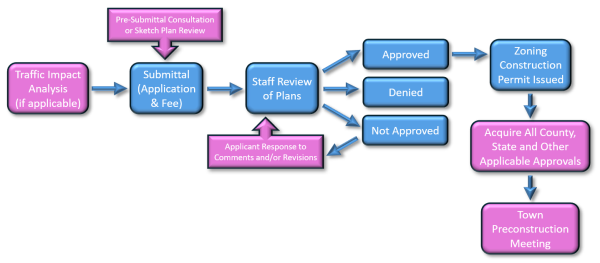
370.020 Pre-Application Conference
Prior to the submission of an application for site plan approval, all potential applicants are strongly encouraged to request a pre-application conference with Town staff. The purpose of the conference is to respond to any questions which the applicant may have regarding any application procedures, standards, or regulations required by this UDO. Upon receipt of such request, the Town staff will afford the potential applicant an opportunity for such a pre-application conference at the earliest reasonable time. The Planning Director has the authority to require a pre-application conference based on anticipated impacts the project may have on surrounding properties.
370.030 Application Requirements
The required details for a site plan will be consistent with those required by Section 350.050A of this ordinance. The Planning Director may also require the following when deemed necessary:
- Traffic Impact Analysis A traffic impact analysis may be required in accordance with the Town of Indian Trail’s Traffic Impact Analysis policy and Chapter 1340.
- Environmental Impact Analysis An environmental impact analysis may be required if it is determined sensitive resources may be impacted as a result of the development.
- School Impact Study A school impact study for residential developments of fifty (50) lots/units or greater as required in UDO Chapter 13140 shall also accompany the application unless previously submitted through the rezoning approval process.
- Waiver of Application Requirements The Planning Director will have the authority to waive any of the application requirements when he determines that the requisite information is not necessary to understand the application and the application complies with this UDO.
370.040 Review Comments, Responses And Approvals
- Payment of Review Fees
After an application is deemed complete, the fees must be paid before Town Staff issues review comments. - Review Comments
After Staff determines that the application package is complete, the Planning Director and/or the Engineering Director will review site plans submitted under this Section. After the review of the plans and if the plans are not approved, the Town will issue a letter containing review comments. The applicant shall submit a response to each of the comments and, if applicable, any revised plans or documents to the Town. - Approval by Planning Director
Site plans submitted for review under this Section will be processed and the applicant notified in writing of such approval, approval with conditions, not approved with continuing review (see B, Review Comments), or denial. In the case of a denial, the applicant may appeal this denial to the Planning and Zoning Board in a quasi-judicial procedure. The Planning Director may grant approval with conditions only to the extent that such conditions specify the actions necessary to bring the application into complete compliance with this UDO. If the proposed site plan is determined to be consistent with all applicable provisions of this UDO, the Planning Director will approve the site plan and so advise the applicant in writing. The site plan development approval is attached to and runs with the land unless the approval expires. - Expiration of Approval
If a site plan approval expires, the Planning Director will provide the property owner notification in writing. An approved site plan will expire two (2) years from the date of approval unless the proposed development is pursued as set forth below:- A complete building permit application has been submitted or, if no building permit is required, a certificate of occupancy has been issued; or
- In case of projects that are to built out in phases, the applicant may submit a schedule for construction subject to review and approval by the Planning Director. The Director may approve a schedule if it is determined that the applicant will comply with the intent of this Section and the Director determines that the applicant plans to diligently pursue the development.
380.010 Planning And Zoning Board Hearings On Appeals
- An appeal from any final order, interpretation or decision of the Planning Director may be taken to the Planning and Zoning Board by any person with standing pursuant to G.S. 160D-1402 (d). An appeal is taken by filing with the Town Clerk a written notice of appeal specifying the grounds therefore.
- The official who made the decision shall give notice to the owner of property that is the subject of the decision and to the party who sought the decision, if different from the owner.
- The owner or other party shall have 30 days from receipt of the written notice within which to file an appeal. Town staff shall presume that a notice sent by mail is received on the third (3rd) day after the mailing.
- It shall be conclusively presumed that all persons with standing to appeal have constructive notice of decision from the date a sign containing the words “Zoning Decision” or “Subdivision Decision” in letters at least six (6) inches high and identifying the means to contact an official for information about the decision is prominently posted on the property that is the subject of the appeal. The posting of signs is not the only form of constructive notice. Any such posting shall be the responsibility of the landowner or applicant. Verification of the posting shall be provided to the official who made the decision. Absent an ordinance provision to the contrary, posting of signs shall not be required.
- Whenever an appeal is filed, the official making the decision must, at once, transmit to the Planning and Zoning Board all the documents and exhibits constituting the record relating to the action appealed from. The official shall also provide a copy of the record to the appellant and to the owner of the property that is the subject of the appeal if the appellant is not the owner.
- Pursuant to G.S. 160D-405 (f), an appeal of a notice of violation or other enforcement order stays enforcement of the action appealed from and accrual of any fines assessed unless the official who made the decision certifies to the Board after notice of appeal has been filed that because of the facts stated in an affidavit, a stay would cause imminent peril to life or property or because the violation is transitory in nature, a stay would seriously interfere with enforcement of the development regulation. In that case, enforcement proceedings shall not be stayed except by a restraining order, which may be granted by a court. If enforcement proceedings are not stayed, the appellant may file with the official a request for an expedited hearing of the appeal, and Board shall meet to hear the appeal at the next scheduled meeting after such a request is filed. Notwithstanding the foregoing, appeals of decisions granting a development approval or otherwise affirming that a proposed use of property is consistent with the development regulation shall not stay the further review of an application for development approvals to use such property; in these situations the appellant or Town may request and the board may grant a stay of a final decision of development approval applications, including building permits affected by the issue being appealed.
- Subject to the provision of subdivision (F) of this subsection, the Planning and Zoning Board shall hear and decide the appeal within a reasonable time.
- Planning Department Staff shall submit the required public hearing notifications in accordance with the table in Section 310.020 Summary of Notice Required and applicable paragraphs in Section 310.030 Required Notice for Public Hearings.
- The official who made the decision shall be present at the hearing as a witness. The appellant shall not be limited at the hearing matters stated in the notice of appeal. If any party or the Town would be unduly prejudiced by the presentation of matters not presented in the notice of appeal, the board shall continue the hearing.
- The Planning and Zoning Board may reverse or affirm (wholly or partly) or may modify the order, requirement or decision or determination appealed from and will make any order, requirement, decision or determination that in its opinion ought to be made in the case before it. To this end, the board will have all the powers of the officers from whom the appeal is taken.
- When hearing an appeal pursuant to G.S. 160D-947 (e) or any other appeal in the nature of certiorari, the hearing shall be based on the record and the scope of review shall be as provided G.S. 160D-1402 (k).
- The parties to an appeal that has been made under this subsection may agree to mediation or other forms of alternative dispute resolution. The ordinance may set standards and procedures to facilitate and manage such voluntary alternative dispute resolution.
Amended by Ord. O210209-347 on 2/8/2021
Amended by Ord. 397 on 3/26/2024
Amended by Ord. 410 on 12/10/2024
380.020 Planning And Zoning Board Hearings On Variances
- An application for a variance to the Planning and Zoning Board will be made by filing a copy of the completed application in the office of the Planning Director.
- A variance may be granted by the Planning and Zoning Board after a public hearing has been held in a quasi-judicial manner and advertised in accordance with Section 310.030. When unnecessary hardships would result from carrying out the strict letter of the Unified Development Ordinance, the Planning and Zoning Board shall vary any of the provisions on the ordinance upon a showing of all of the following:
- Unnecessary hardship would result from the strict application of the regulation. It shall not be necessary to demonstrate that, in the absence of the variance, no reasonable use can be made of the property; and
- The hardship results from conditions that are peculiar to the property, such as location, size, or topography. Hardships resulting from personal circumstances, as wells as hardships resulting from conditions that are common to the neighborhood or the general public, may not be the basis for granting a variance. A variance may be granted when necessary and appropriate to make a reasonable accommodation under the Federal Fair Housing Act for a person with a disability; and
- The hardship did not result from actions taken by the applicant or the property owner. The act of purchasing property with knowledge that circumstances exist that may justify the granting of a variance shall not be regarded as self-created hardship; and
- The requested variance is consistent with the spirit, purpose and intent of the regulation, such that public safety is secured and substantial justice is achieved.
- No change in permitted uses may be authorized by a variance.
- Appropriate conditions may be imposed on any variance, by the Planning and Zoning Board, provided that the conditions are reasonably related to the variance. Any other ordinance that regulates land use for development may provide for the variances consistent with the provisions of the subsection. A variance may be issued for an indefinite duration or for a specified duration only.
- The nature of the variance and any conditions attached to it must be entered on the face of the zoning permit, or the zoning permit may simply note the issuance of the variance and refer to the written record of the variance for further information. All such conditions are enforceable in the same manner as any other applicable requirement of this ordinance.
Amended by Ord. O210209-347 on 2/8/2021
Amended by Ord. 410 on 12/10/2024
Amended by Ord. 423 on 1/13/2026
380.030 Hearings On Appeals Or Variances
The Planning and Zoning Board will hear and decide all appeals, and variance requests, as expeditiously as possible, consistent with the need to follow regularly established agenda procedures, provide notice in accordance with Section 310.030, and obtain the necessary information to make sound decisions.
- Burden of Proof in Appeals and Variances
- When an appeal is taken to the Planning and Zoning Board in accordance with Chapter 380 (Appeals and Variances), the Planning Director will have the initial burden of presenting to the board sufficient evidence and argument to justify the order or decision appealed from. The burden of presenting evidence and argument to the contrary then shifts to the appellant, who will also have the burden of persuasion.
- The burden of presenting evidence sufficient to allow the Planning and Zoning Board to reach the conclusions set forth in Section 380.020B, as well as the burden of persuasion on those issues remains with the applicant seeking the variance.
- The applicant has the burden of producing competent, material, and substantial evidence establishing that the applicant's proposed use will not substantially injure the value of adjoining or abutting property and will be in general conformity with the comprehensive plan, thoroughfare plan, or other plans or policies officially adopted by the Town Council. The burden of proof will be on anyone in opposition of the application to establish by competent, material, and substantial evidence that the applicant's use will materially endanger the public health or safety and will not be in harmony with the area in which it is to be located.
- Board Action on Appeals and Variances
- With respect to appeals, a motion to reverse, affirm, or modify the order, requirement, decision, or determination appealed from will include, insofar as practicable, a statement of the specific reason or findings of facts that support the motion. If a motion to reverse or modify is not made or fails to receive the votes necessary for adoption, then a motion to uphold the decision appealed from will be in order.
- Before granting a variance, the board must take a separate vote and vote affirmatively on each of the six required findings stated in Section 380.020B. Insofar as practicable, a motion to make an affirmative finding on each of the requirements set forth in Section 380.020B will include a statement of the specific reasons or findings of fact supporting such motion. Said approved variance shall be recorded at the Union County Registrar of Deeds within 60 days from the date of approval.
- A motion to deny a variance may be made on the basis of findings regarding any one or more of the criteria set forth in Section 380.020B. Insofar as practicable, such a motion will include a statement of the specific reasons or findings of fact that support it.
380.040 Reconsideration Of Planning And Zoning Board Action
- Whenever the Planning and Zoning Board disapproves an application for a variance, on any basis other than the failure of the applicant to submit a complete application, such action may not be reconsidered by the respective board for at least twelve (12) months or unless the applicant clearly demonstrates that:
- Circumstances affecting the property that is the subject of the application have substantially changed; or
- New information is available that could not with reasonable diligence have been presented with as part of the previous application. A request to be reheard on this basis must be filed with the Planning Director within the time period specified within the rules of procedure of the Planning and Zoning Board.
- Notwithstanding Subsection A above, the Town Council or Planning and Zoning Board may at any time consider a new application affecting the same property as an application previously denied if the new application is one that differs in some substantial way from the one previously considered.
390.010 Purpose And Intent
- To better structure and manage development approvals for projects occurring in multiple phases over several years and ensure their proper integration into the Town capital facilities programs, the Town may negotiate and enter into development agreements with developers pursuant to G.S. Chapter 160D, Article 10. Development Agreements.
- A development agreement must be approved by Town Council following the hearing subsection "B" under section 390.020 Process.
- The Town or any other local government may not exercise any authority or make any commitment not authorized by general or local act and may not impose any tax or fee not authorized by otherwise applicable law pursuant to G.S. 160D-1001 (b).
- The development agreement is supplemental to the powers conferred upon local governments and does not preclude or supersede rights and obligations established pursuant to other law regarding development approvals, site-specific vesting plans, phased vesting plans, or other provisions of law (G.S. 160D-1001 (c)).
- The development agreement shall not exempt the property owner or developer from compliance with the State Building Code or State or local housing codes that are not part of the Town's development regulations (G.S. 160D-1001 (c)).
- The provisions of plan consistency, G.S. 160D-605 (a), apply when the Town Council approves the rezoning of any property associated with a development agreement (G.S. 160D-1001 (c)).
- Development authorized by a development agreement shall comply with all applicable laws, including all ordinances, resolutions, regulations, permits, policies, and laws affecting the development of property, including laws governing permitted uses of the property, density, intensity, design, and improvements (G.S. 160D-1001 (d)).
- Size and Duration. The Town may enter into a development agreement with a developer for the development of property for developable property of any size pursuant to G.S. Chapter 160D, Article 10. Development Agreements. Development agreements shall be of a reasonable term specified in the agreement.
390.020 Process
- Options for Consideration
- The development agreement may, by ordinance, be incorporated, in whole or in part, into any development regulation adopted by the Town.
- A development agreement may be considered concurrently with a zoning map or text amendment affecting the property and development subject to the development agreement.
- A development agreement may be concurrently considered with and incorporate by reference a sketch plan or preliminary plan required under a subdivision regulation or a site plan or other development approval required under a zoning regulation.
- If incorporated into a conditional district, the provisions of the development agreement shall be treated as a development regulation in the event of the developer's bankruptcy.
- Hearing
- Before entering into a development agreement, the Town shall conduct a legislative hearing on the proposed agreement.
- The notice provisions applicable to zoning map amendments shall be followed for this hearing. The notice must specify the location of the property subject to the development agreement, the development uses proposed on the property, and a place where a copy of the proposed development agreement can be obtained.
- Recordation
- The developer shall record the agreement with the Union County Register of Deeds within 14 days after the local government and developer execute an approved development agreement pursuant to G.S. 160D-1011. The developer shall provide the Town with a digital and hard copy version of the recorded agreement.
- No development approvals may be issued until the development agreement has been recorded.
390.030 Content Required
- A development agreement shall, at a minimum, include all of the following pursuant to G.S. 160D-1006 (a):
- A description of the property subject to the agreement and the names of the legal and equitable property owners.
- The duration of the agreement. The parties are not precluded from entering into subsequent development agreements that may extend the original duration period.
- The development uses permitted on the property, including population densities and building types, intensities, placement on the site, and design.
- A description of public facilities that will service the development.
- The description shall include who provides the facilities, the date of any new public facilities that may be constructed, and a schedule to assure public facilities are available concurrent with the impacts of the development.
- In the event that the development agreement provides that the Town shall provide certain public facilities, the agreement shall provide that the delivery date of such public facilities will be tied to successful performance by the developer in implementing the proposed development (such as meeting defined completion percentages or other performance standards).
- A description, where appropriate, of any reservation or dedication of land for public purposes and any provisions agreed to by the developer that exceed existing laws related to protection of environmentally sensitive property.
- A description, where appropriate, of any conditions, terms, restrictions, or other requirements for the protection of public health, safety, or welfare.
- A description, where appropriate, of any provisions for the preservation and restoration of historic structures.
- A development agreement may also provide that the entire development or any phase of it be commenced or completed within a specified period of time (G.S. 160D-1006 (b)).
- If required by ordinance or in the agreement, the development agreement shall provide a development schedule, including commencement dates and interim completion dates at no greater than five (5)-year intervals; provided, however, the failure to meet a commencement or completion date shall not, in and of itself, constitute a material breach of the development agreement pursuant to G.S. 160D-1008 but must be judged based upon the totality of the agreement.
- The developer may request a modification in the dates as set forth in the agreement.
- If more than one local government is made party to an agreement, the agreement must specify which local government is responsible for the overall administration of the development agreement. A local or regional utility authority may also be made a party to the development agreement (G.S. 160D-1006 (c)).
- The development agreement also may cover any other matter including the following pursuant to G.S. 160D-1006 (d)):
- Defined performance standards, not inconsistent with G.S. 160D-1006.
- Mutually acceptable terms regarding provision of public facilities and other amenities and the allocation of financial responsibility for their provision, provided any impact mitigation measures offered by the developer beyond those that could be required by the Town pursuant to G.S. 160D-804 shall be expressly enumerated within the agreement, and provided the agreement may not include a tax or impact fee not otherwise authorized by law.
- Consideration of a proposed major modification of the agreement shall follow the same procedures as required for initial approval of a development agreement. What changes constitute a major modification may be determined by ordinance adopted pursuant to section 390.020 Process or as provided for in the development agreement. (G.S. 160D-1006 (e))
- Any performance guarantees under the development agreement shall comply with the subdivision regulations in G.S. 160D-804 (d) for recreation areas and open space. (G.S. 160D-1006 (f))
390.040 Effect Of Approval
- Vesting
- Unless the development agreement specifically provides for the application of subsequently enacted laws, the laws applicable to development of the property subject to a development agreement are those in force at the time of execution of the agreement. This subsection on vesting is from G.S. 160D-1007.
- The Town may not apply subsequently adopted ordinances or development policies to a development that is subject to a development agreement except for grounds specified in G.S. 160D-108 (e).
- In the event a State or federal law is changed after a development agreement has been entered into and the change prevents or precludes compliance with one or more provisions of the development agreement, the Town may modify the affected provisions, upon a finding that the change in State or federal law has a fundamental effect on the development agreement.
- This vesting does not abrogate vested rights otherwise preserved by law.
- Breach of Agreement and Cure
- If at any time the Town finds and determines that the developer has committed a material breach of the agreement, the Town shall notify the developer in writing setting forth with reasonable particularity the nature of the breach and the evidence supporting the finding and determination, and providing the developer a reasonable time in which to cure the material breach pursuant to G.S. 160D-1008.
- If the developer fails to cure the material breach within the time given, then the Town unilaterally may terminate or modify the development agreement; provided, the notice of termination or modification may be appealed to the Planning and Zoning Board in a quasi-judicial proceeding.
- A development agreement may specify other penalties for breach in lieu of termination, including but not limited to, penalties allowed for violation of a development regulation.
- A development agreement shall be enforceable by any party to the agreement notwithstanding any changes in the development regulations made subsequent to the effective date of the development agreement. Any party to the agreement may file an action for injunctive relief to enforce the terms of a development agreement.
- Amendment or Termination
A development agreement may be amended subject to subsection "E" of Section 390.030 Content Required or terminated by mutual consent of the parties. - Change of Jurisdiction
- Except as otherwise provided by Article 10 of G.S. Chapter 160D, any development agreement entered into by a local government, such as Union County, before the effective date of a change of jurisdiction shall be valid for the duration of the agreement, or eight (8) years from the effective date of the change in jurisdiction, whichever is earlier.
- A local government assuming jurisdiction may modify or suspend the provisions of the development agreement if the local government determines that the failure of the local government to do would place the residents of the territory subject to the development agreement, or the residents of the local government, or both, in a condition dangerous to their health or safety, or both. (G.S. 160D-1010 (b))
- Applicability of Procedures to Approve Debt.
In the event that any of the obligations of the Town in the development agreement constitute debt, the Town shall comply, at the time of the obligation to incur the debt and before the debt becomes enforceable against the Town, with any applicable constitutional and statutory procedures for the approval of this debt pursuant to G.S. 160D-1012