
Indian Trail City Zoning Code
DIVISION 1600
TERMINOLOGY AND MEASUREMENTS
O210209-347
410
O211012-367
397
423
1610.010 Interpretation Of Words And Phrases
- Unless specifically defined below, words or phrases use in this ordinance shall be interpreted so as to give them the meaning they have in common usage and to give this ordinance it's most reasonable application.
- Typical uses cited in the description are not intended to be exclusive or restrictive.
1610.020 Determining Use Type Classification Or Definition
- When a specific use type cannot be readily classified or appears to fit into two or more definitions, the Planning Director is authorized to determine the most similar, thus most appropriate, use based on the following considerations:
- The actual or projected characteristics of the activity in relationship to the stated characteristics of each use type;
- The relative amount of site area or floor space and equipment devoted to the activity;
- Relative amounts of sales from each activity;
- The customer type for each activity;
- The relative number of employees in each activity;
- Hours of operation;
- Building and site arrangement;
- Vehicles used with the activity;
- The relative number of vehicle trips generated by the use;
- Signs;
- How the use advertises itself; and
- Whether the activity is likely to be found independent of the other activities on the site.
1620.010 Definitions - "A"
Accessory Apartment
A residential addition for living purposes, whether attached or detached, that is incidental and subordinate to a principal residential dwelling unit characterized by the presence of separate sleeping quarters, bathroom facilities, and a full kitchen or food preparation facility.
Accessory Building
A building that is subordinate in area, extent and purpose to the principal use and building on the lot and that is customarily used or occupied in conjunction with a permitted accessory use.
Accessory Structure
A structure that is subordinate in area, extent and purpose to the principal use and building on the lot and that is customary and incidental to a permitted accessory use.
Accessory Use
A use that is subordinate in area, extent and purpose to the principal use on the zoning lot and that is customarily found in conjunction with a permitted principal use.
Airport, Public Use
Any publicly or privately-owned airport licensed as a public airport, which meets minimum safety and service standards and is open for use to the general flying public.
Alley
A public or private right-of-way primarily designed to serve as access to the side or rear of those properties whose principle frontage is on some other street.
Alteration
Any addition, removal, extension, or change in the location of an exterior wall or roof of a principal building or accessory building.
Alteration, Structural
Any change in the supporting members of a building or structure, such as bearing walls, columns, beams, or girders.
Alternative Methods of Compliance
Alternate tree planting plans, plant materials, planting methods, or reforestation may be used where unreasonable or impracticable situations would result from application of the tree planting and preservation requirements.
ANSI
American National Standards Institute (ANSI) is a private, non-profit organization (501©3) that administers and coordinates the U.S. voluntary standardization and conformity assessment system. This includes tree care operations for trees, shrubs and other woody plant maintenance. www.ansi.org.
Appeal
An action requesting reversal or modification of a decision made by the Planning Director based on his/her interpretations of the code. Appeals are made to the Town Planning and Zoning Board in a quasi-judicial proceeding.
Arterial Street
A street, identified as an arterial street on the Indian Trail Comprehensive Plan, intended to move through traffic to and from the major traffic generators and to serve as a route for traffic between communities or large areas.
Augering
A practice of tunneling under to reduce the damage to and loss of individual trees where underground construction involves a tree's CRZ (Critical Root Zone).
1620.020 Definitions - "B"
Bar
An establishment where the primary business is the sale of alcoholic beverages, which may be in conjunction with the provision of live music, dancing, or other entertainment, such as comedy, theatre, or the viewing of televised sporting events. Food may be served but is not the primary focus of the establishment.
Basement
That portion of a structure between the floor and ceiling which is wholly or partly below grade and having more than one-half of its height below grade.
Berm
A man-made mound of earth designed and intended to shield or buffer properties from adjoining uses, highways, and streets.
Block
A tract of land bounded by streets or by any combination of streets, public parks, cemeteries, railroad rights-of-way, waterways, boundary lines of municipalities, or other natural or man-made features.
Block Face
All lots abutting one side of a street between the two nearest intersecting streets.
Bufferyard
A continuous area of land along the perimeter of a lot including landscaping, trees, walls, fences, berms and any combination thereof that is designed to physically and visually separate one use of the property from another in order to mitigate the impacts of noise, light, or other nuisance.
Building
An enclosed structure anchored to a permanent foundation and having exterior or party walls and a roof, designed for the support or shelter of any use or occupancy such as persons, animals, or property. When divided by other than common or contiguous walls, each portion or section of such building is to be considered a separate building.
Building Coverage
The proportion of the lot area expressed as a percent that is covered by the maximum horizontal cross-section of a building or buildings.
Building Line
An imaginary line that coincides with the location of the exterior building wall of a building.
Building Height
Look under "Height, Building" for definition.
Building, Setback Line
A line establishing the minimum allowable distance between the nearest portion of any building and the street right-of-way line or any other lot line when measured perpendicularly.
Business Park
A defined area of land with multiple employment-generating establishments in fields such as manufacturing, processing and assembly, warehousing, distribution and service enterprises, office, and ancillary service establishments. Business parks are typically defined by common or shared development features that may include, but are not limited to architectural design, landscaping, signage, roadway access, stormwater management, and other features. A single, standalone building located outside a park environment would not be considered a business park.
1620.030 Definitions - "C"
Caliper
A diameter measurement of the tree trunk taken at 6 inches above ground level for trees up to and including four (4) inches in caliper. For larger trees over four (4) inches in caliper, the measurement shall be taken at 12 inches above ground level.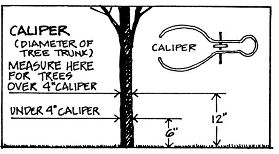
Canopy
The uppermost spreading branchy layer of a tree.
Canopy Cover
The area that a tree’s canopy shades. This area should coincide with the drip line.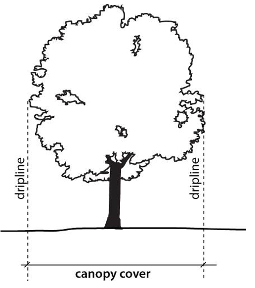
Canopy Trees
A deciduous tree with height at maturity greater than 35 feet which produces significant shade due to the size and shape of its canopy.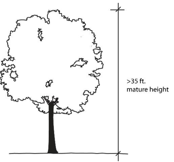
Certified Arborist
A person who is properly licensed through a combination of either a professional certification or ISA certification as a Certified Arborist. See Appendix 4 for a list of local certified Arborists.
Charitable Events
An event where proceeds, if any, will directly benefit a charitable organization that maintains a 501 (c) (3) charitable status.
Civic Organization
Any local service club, veterans' post, fraternal society, or association operated exclusively for educational or charitable purposes and the net earnings of which are devoted exclusively to charitable, educational, recreational, or social welfare purposes.
Clear Cut
Felling and removal of all trees from an area. Typically an indiscriminate removal of trees except in the case of silvicultural harvesting where tree removal is followed up with a forest replanting or regeneration effort to keep the land forested.
Cluster Plantings
A grouping of three (3) or more plants installed in close proximity to one another.
Cluster of Trees
A group of trees gathered together in their natural state.
Cluster Subdivision
A type of subdivision that permits a reduction in lot area and lot frontage provided there is no increase in the overall density of the development and where the remaining land created by the smaller lots is devoted to permanent open space, active recreation space, or the preservation of environmentally sensitive areas.
Collector Street
A street identified as a collector street on the Thoroughfare Plan, intended to move traffic from minor streets to arterial streets. The collector street is similar to a minor thoroughfare but carrying less through traffic.
Commercial Establishment
A business classified in the commercial use group, the ownership, management and physical location of which are separate and distinct from those of any other place of business located on the same lot, as partly evidenced by maintaining separate and distinct doors and access points.
Commercial Message
Any sign, wording, logo, symbol, picture, any combination, or other representation that, directly or indirectly, names, advertises or calls attention to a business, product, commodity, service, entertainment, or other commercial activity sold or offered for sale or a fee.
Comprehensive Plan
A document that links Town development policy, short- and long-range objectives and implementation strategies to a number of interdependent elements. The elements of the Comprehensive Plan are based on the present and future needs of the Town. The core elements of the Comprehensive Plan include Economic Development; Land Use; Transportation; Community Facilities; Utilities; Historic Preservation; Neighborhood Development; Parks and Recreation; and Environmental and Natural Resource Preservation. The elements of the Comprehensive Plan are to be adopted by the Planning Commission and Town Council, and are to be used as a guide for development.
Condominium
A form of property ownership in which the buildings or portions of the buildings, whether residential or non-residential in use, are owned by individuals separate from the lands which surrounds the building, said lands held in common ownership by the owners of the individual buildings.
Contiguous
Lots are contiguous when at least one boundary line of one lot touches a boundary line or lines of another lot.
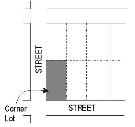
Corner Lot
A lot which occupies the interior angle at the intersection of two (2) street lines which make an angle of more than forty-five (45) degrees and less than one hundred thirty-five (135) degrees with each other. The street line forming the least frontage shall be deemed the front of the lot except where the two (2) street lines are equal, in which case, the owner shall be required to specify which is the front at the time the owner is requesting a building permit.
County
Union County.
Cul-De-Sac
A local street with only one outlet and having an appropriate terminus at one end for the safe and convenient reversal of traffic movement.
Cutoff Fixture
A fixture that provides shielding in some form or fashion to limit the amount of light or glare that is produced. Fixture designation would be non-shielded, semi-cutoff and full cutoff.
1620.040 Definitions - "D"
DBH
See "Diameter at Breast Height".
Deciduous
Plants or trees that lose their leaves annually.
Deciduous Tree
Those trees which drop all of their leaves annually, such as Ash, Sycamore, Willow, Maple, etc.
Dedication
A gift, by the owner, or a right to use of land for a specified purpose or purposes. Because a transfer of property rights is entailed, dedication must be made by written instrument, and is completed with an acceptance.
Department of Environmental Health
The Union County Department of Environmental Health.
Department of Environmental Quality
The North Carolina State Department of Environmental Quality (DEQ). Formally named the Department of Environment and Natural Resources (DENR).
Developer
A person, firm or corporation undertaking development or building on a lot, tract or parcel of land. Includes subdividers, builders and property owners.
Development
The act, process or state of erecting buildings or structures, or making improvements.
Development Permits
A permit issued by the Planning Director that authorizes the recipient to make use of property in accordance with the requirements of this ordinance.
Development Standards
See definition for the "Land Development Standards (ITLDS), Indian Trail" under 1620.120, Definitions - "L".
Diameter at Breast Height (DBH)
A measurement of the size of a tree equal to the diameter of its trunk measured 4-1/2 feet above natural grade.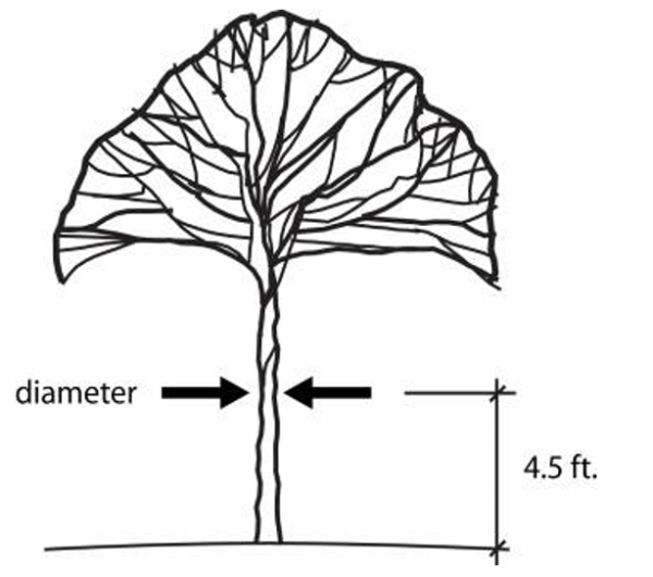
Direct Glare
The effect causing visual discomfort resulting from insufficiently shielded light sources in the field of view.
Disability, Person with
A person who has a condition of physical or mental disability that substantially limits one or more major life activities, as provided in Section 168-21 (2) of the North Carolina General Statutes.
Display Lighting
Lighting for uses such as auto dealerships, outdoor storage areas, retail establishments and outdoor displays.
District
Referring to a zoning district.
Double Frontage Lot
A parcel or property with frontage on 2 or more streets that do not intersect (also known as “through lot”).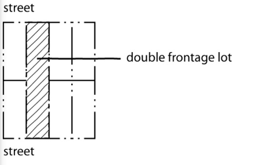
Drip Line
An imaginary vertical line extending from the outermost portion of the tree canopy to the ground.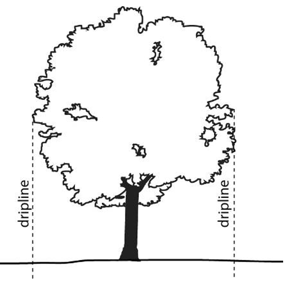
Drive-Through Facility
Any service window, automated device or other facility that provides goods or services to individuals in a motor vehicle. Includes drive-in and drive-thru type uses.
Dwelling
A building that contains one or two dwelling units used, intended or designed to be used, rented, leased, let or hired out to be occupied for living purposes. (2012 NC Building Code)
Dwelling Unit
A single unit providing complete, independent living facilities for one or more persons, including permanent provisions for living, sleeping, eating, cooking, and sanitation. (2012 NC Building Code)
1620.050 Definitions - "E"
Easement
A grant by the property owner to the public, a corporation, or persons of the use of that land for specific purposes.
Electronic Gaming Device or Machine
A device or machine operated electrically, electronically or mechanically as a computer that is used for internet games. Machines may use software and/or require that payment be in the form of a credit card, prepaid card, debit card, money, token or any other method of payment that will activate a machine. The customer may receive a token, sweepstake ticket, card or another item which will enable them to enter a sweepstake. A customer may also enter a sweepstake by purchasing an item related to the sweepstakes. Also referred to as electronic gaming machine or virtual gaming machine.
Electronic Gaming Operation
A business with electronic gaming device(s) or machine(s) where games of skill or dexterity are played for prizes. Electronic gaming operations may also be referred to as internet sweepstakes, electronic gaming facilities, internet cafés or other similar terms. Lotteries approved by the State of North Carolina are not considered electronic gaming operations.
Electric Vehicle (EV)An automotive-type vehicle for on-road use, such as passenger automobiles, buses, trucks, vans, neighborhood electric vehicles, electric motorcycles, and the like, primarily powered by an electric motor that draws current from a rechargeable storage battery, fuel cell, photovoltaic array, or other source of electric current. Plug-in hybrid electric vehicles (PHEV) are considered electric vehicles. Off-road, self-propelled electric vehicles, such as industrial trucks, hoists, lifts, transports, golf carts, airline ground support equipment, tractors, boats, and the like, are not included.
Electric Vehicle Charger (EV Charger)Off-board charging equipment used to charge an electric vehicle.
Electric Vehicle Charging Space (EV Space)A space intended for future installation of EV charging equipment and charging of electric vehicles.
Electric Vehicle Charging Station (EVCS)One or more electric vehicle charging spaces served by electric vehicle charger(s) or other charging equipment allowing charging of electric vehicles. Electric vehicle charging stations are not considered parking spaces.
Electric Vehicle Supply Equipment (EVSE)The conductors, including the ungrounded, grounded, and equipment grounding conductors and the electric vehicle connectors, attachment plugs, and all other fittings, devices, power outlets, or apparatus installed specifically for the purpose of transferring energy between the premises wiring and the electric vehicle.
Emergency Lighting
Lighting used by or for the purpose of Police Departments, Fire Departments, or other government entities for the purpose of public safety, and the lighting installed for safe occupant egress.
Equestrian Trails
Typically an un-paved path for horse riders that may be routed with and parallel to bike or pedestrian trails. On local streets (i.e. not arterials or thoroughfares) equestrian trails may share a road right-of-way with automobile traffic but in all circumstances such trails will be separated from the road by barriers such as fencing or landscaping. When horse trails are located away from the horse population then amenities such as hitching posts, water supply parking lots, and will be incorporated into the trail design.
Equine
Any horse, pony, donkey, burro, or mule that is 12 months of age or older. Any animal that is under 12 months of age and is the off-spring of or is un-weaned and is being nursed by a female equine lawfully kept on the property will not be subject to any of the limitations of the equestrian subdivision ordinance.
Evergreen
Plants or trees that retain their leaves throughout the year.
Evergreen Trees
Those trees which retain their leaves during dormancy, such as Pine, Juniper, Yews, Fir, etc.
Existing Light Fixture
A lighting fixture installed, or approved by the Town to be installed, pursuant to the effective date of this ordinance.
Existing Tree Canopy
Tree canopy that existed for at least two (2) years prior to development as evidenced by the Town or County aerial photography and/or satellite imagery.
Exotic/Invasive Species
An alien species that becomes established in natural or semi-natural ecosystems or habitats and threatens native plants and when such species spread they threaten biological diversity. Invasive species include English Ivy-Hedera helix, Chinese Wisteria-Wisteria sinensis, Japanese Wisteria-Wisteria floribunda, Japanese Honeysuckle-Lonicera japonica, Kudzu-Pueraria Montana.
1620.060 Definitions - "F"
Fence
A structure, other than a building, purposely designed for and used as a barrier to provide a boundary, means of confinement or protection, or visual screen for areas of land.
Final Subdivision Plat, Final Plat or Recorded Plat
The map of a subdivision to be recorded after approval by the Town Council or Planning Director.
Flag Lot
A lot having the required width at the building line, but having access to a dedicated street only by means of a corridor of less width. Sometimes referred to as “panhandle lots".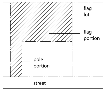
Flood Light (or Spot Light)
Any light fixture or lamp that incorporates a reflector or a refractor to concentrate the light output into a directed beam in a particular direction.
Floodplain
Any land area susceptible to being inundated by water from the base flood. As used in this ordinance, the term refers to that area designated as subject to flooding from the base flood (one hundred year flood) on the "Flood Boundary and Floodway Map" prepared by the U.S. Department of Housing and Urban Development and dated July 18, 1983, a copy of which is on file in the administrator's office.
Floodway
The channel of a river or other watercourse and the adjacent land areas that must be reserved in order to discharge the base flood without cumulatively increasing the water surface elevation more than one foot. As used in this ordinance, the term refers to that area designated as a floodway on the "Flood Boundary and Floodway Map" prepared by the U.S. Department of Housing and Urban Development and dated July 18, 1983, a copy of which is on file in the administrator's office.
Floor Area
The gross floor space within the exterior walls of a building, not including space in cellars or basements.
Food Trucks (or Mobile Food Vending Units)
The following definitions shall apply for Mobile Food Vendor Units and variations thereof:
- Commissary
A location that the Union County Health Department has deemed to be an acceptable location to safely prepare food and utensils, dispose of grease and garbage and other food prep related activities. May also be referred to as a commercial kitchen. Mobile food vending units may be stored there when not in use. - Mobile Food Vendor
Any person selling food from a mobile vehicle. - Mobile Food Vending Unit
Any motorized or nonmotorized vehicle, trailer, food truck, or other device designed to be portable and not permanently attached to the ground from which food is vended, served or offered for sale. This unit, which leaves its point of sale location, returns daily to its base of operations and is used for either the preparation or sale of food products, or for both.
Forest Management Plan
A document that defines a landowner’s forest management objectives and describes specific measures to be taken to achieve those objectives.
Footcandle (FC)
A quantitative unit measuring the amount of light cast onto a given point, measured as one lumen per square foot.
Frontage
That portion of a lot abutting a public or private street. On corner lots front yards requirements will be determined on the basis of the orientation of a building’s main entrance to the street but, for the purposes of the landscaping requirements, street tree plantings and street front landscaping applies to all property lines abutting a street.
Frontage Road
A frontage road is a local street or road that is parallel to a full or partial access controlled facility and functions to provide access to adjacent land.
Full Cutoff Fixture
An outdoor light fixture shielded or constructed in such a manner that it emits no light above the horizontal plane of the fixture.
1620.070 Definitions - "G"
Grade
The slope of a road, street, or other public way specified in percentage terms.
Grading or Land Disturbing
Any use of land by any person that results in a change of the natural cover or topography and that may cause or contribute to sedimentation or soil compaction.
Ground Cover
Low-growing plants or turf grass, installed to form a mostly continuous cover over the ground surface.
1620.080 Definitions - "H"
Height, Building
Building height shall be measured from the average elevation of the highest and lowest finished grade points (average grade) of that portion of the lot covered by the building to the highest point of the roof beams adjacent to the front of the wall in the case of a flat roof, or to the average height of the gables in the case of a pitched roof.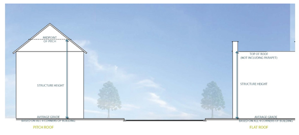
Height, Non-Building Structure
Non-building structure height (signs, fences, cell towers, flag poles, water tanks, and the like) shall be measured from the finished grade at the base of the non-building structure to the highest point of the non-building structure. When the elevation of the driveway or roadway providing access to the site varies by more than four (4) feet, the Planning Director may utilize the elevation of the driveway or roadway providing access to the site when determining height.
Heritage Tree
- A deciduous tree that is 14 inches in diameter or larger measured at 4.5 feet above grade (i.e., diameter at breast height). Deciduous trees include but are not limited to oak, hickory, elm, crepe myrtle, etc.
- An evergreen tree that is 18 inches in diameter or larger measured at 4.5 feet above grade (i.e. diameter at breast height). Evergreen trees include but are not limited to pines, cedars, etc.
- Specific tree species that shall not be considered Heritage Trees, regardless of the diameter size are as follows: Bradford Pear, Magnolia, Mimosa, Mulberry, Silver Maple and Sweet Gum.
Household
One or more persons related by blood, marriage, legal adoption or guardianship, plus not more than four (4) additional persons, all of whom live together as single housekeeping unit.
1620.090 Definitions - "I"
Illuminating Engineering Society
The Illuminating Engineering Society of North America, a non-profit professional organization of lighting specialists that has established recommended design standards for various lighting applications.
Impervious Surface (or Impervious Cover)
A surface that has been compacted or covered with a layer of material so that it is highly resistant to infiltration by water. It includes surfaces such as compacted sand, lime rock, or clay, as well as most conventionally paved streets, roofs, sidewalks, parking lots, and other similar improvements.
Interior Lot
A lot whose side lines do not abut upon any street.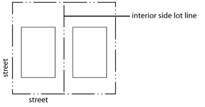
Interior Parking Lot Landscaping
Landscape located within a paved parking area planted with live plant material, such as trees, shrubs, groundcover, or turf grass.
Intermittent Stream
A stream or portion of a stream that flows only in direct response to precipitation. It receives little or no water from springs and only temporary supply from melting snows or other sources.
Intersection
The crossing of two (2) or more streets at the same elevation.
1620.120 Definitions - "L"
Lake or Watercourse
Any stream, river, brook, swamp, creek, run, branch, waterway, reservoir, lake, or pond, natural or impounded, in which sediment may be moved or carried in suspension and which could be damaged by accumulation of sediment and pollutants.
Land Clearing
The large scale indiscriminate removal of trees, shrubs, and undergrowth with the intention of preparing real property for non-agricultural development.
Land Development Standards (ITLDS), Indian Trail
The manual of construction standards and details prepared by the Engineering Director which regulates and controls the provisions and construction of public and private improvements relating to streets, sidewalks, drainage and other facilities.
Landlocked
A lot that does not abut any street.
Landmark
A property or structure designated as a “Landmark” by ordinance of the Town Council because it meets one or more of the national criteria for landmarks as established by the U.S. Department of Interior contained in 36 CFR 65.5 'Designation of National Historic Landmarks".
Landscape Material
Living material as trees, shrubs, ground cover/vines, turf grasses; nonliving material such as rocks, pebbles, sand, bark, mulch, brick pavers, earthen mounds (excluding pavement); and/or other decorative items such as fountains, pools, walls, fencing, and sculpture.
Landscaped Open Space
All land within the property lines not covered by building or pavement, except that paved outdoor areas used exclusively for pedestrian walkways, plazas, gathering or seating areas, or water features may be considered landscaped open space.
Landscaping
The act of or the result of preservation of natural vegetation; bringing the soil surface to a finished grade; designing the soil surface with berms, installing trees, shrubs, ground cover, grass, and other acceptable materials to soften building lines, provide shade, improve the visual appearance of property, and enhance the environment.
Large Maturing Tree
A tree whose height is greater than 60 feet at maturity and meets the specification of “American Standards for Nursery Stock” published by the American Association of Nurserymen. See also Canopy Tree.
Level of Service (LOS)
Rating conditions or criteria measuring the capacity of public facilities or service providers.
Light Pollution
Any artificial light that is emitted either directly or indirectly by reflection that alters the appearance of the night sky, interferes with astronomical observation, or interferes with the natural functioning of nocturnal native wildlife.
Light Trespass
Effects of light that stray from the intended purpose and becomes an annoyance, a nuisance, or a deterrent to visual performance. As such, light trespass should always be considered negative, unlike spill light, which can have positive or negative attributes. Light trespass is the encroachment of light causing annoyance, loss of privacy, or other nuisance.
Local Street
A local street is any link not a higher-order urban system and serves primarily as a direct access to abutting land and access to higher systems. It offers the lowest level of mobility and through-traffic is usually deliberately discouraged.
Lot
A tract, plot, portion of a subdivision or other unit of land that may be transferred in ownership or used for building development.
Lot Coverage
Impervious surface and partially impervious surface on a lot to the extent that the partially impervious surface does not allow water to infiltrate through the surface and into the subsoil.
- Considered Lot Coverage
Items that shall be added together for a lot coverage total is as follows, but not limited to: asphalt/concrete surfaces; building and shed roofs; tight-slatted patios/decks; gravel; and sidewalks; and the water surface area in an in-ground private swimming pool. - Not Considered Lot Coverage
The following do not contribute to the calculation of lot coverage: a loose slatted deck (a quarter-inch (1/4”) space between decking boards); the water area in an on-ground private swimming pool; or landscaping material that will not be compacted by the weight of a vehicle. The “landscaping material” not to be compacted by a vehicle as previously mentioned is including, but not limited to gravel, mulch, sand, and vegetation.
This lot coverage definition is derived from the definition of “built-upon area” as directed under the NC Administrative Code (NCAC) direction to use § 143-214.7. Stormwater runoff rules and programs, (b2).
Lot Depth
The average horizontal distance from the front lot line to the rear lot line.
Lot Lines
The lines bounding a lot.
Lot Line, Exterior
A lot line abutting a street.
Lot Line, Front
A lot line abutting a street on which the lot fronts. On corner lots it shall be the street side which is the smallest in length.
Lot Line, Interior
A lot line that does not abut a street.
Lot Line, Rear
A lot line that is opposite the front street line, except that in the case of uncertainty the Building Official will determine the rear lot line
Lot Line, Side
Any lot line that is not a front lot line or rear lot line. A side lot line may be an interior lot line or an exterior lot line such as on street side of a corner lot other than a front lot line.
Lot of Record
A lot described by plat or deed and recorded in the Office of the Register of Deeds of Union County, North Carolina.
Luminaire
The complete lighting system, which includes the lamp (or lamps) and the fixture.
Luminaire Pole Height
The total measurement from a paved or landscaped surface at ground level under the fixture to the further most point on top of the luminaire.
1620.130 Definitions - "M"
Maintained Footcandles
The level of illumination present after a typical one hundred (100) hour burn-in period. Typically less than the original “initial” footcandle level that is present at the time of the installation.
Major Street
A street classified on the Thoroughfare Plan of the Town of Indian Trail, North Carolina, as a Boulevard, Arterial Street or Collector Street.
Major Subdivision
Any subdivision that results in the creation of more than five (5) lots out of a single tract and requires the construction of new streets or street rights-of-way or improvements to existing roads; the extension of rights-of-way or easements for public water or sewer facilities; the installation of drainage improvements through one or more lots; or the installation of a private waste water treatment plant or a private water supply system for more than one lot or building site.
Major Thoroughfares (Boulevards)
Major thoroughfares consist of Interstate, other freeway and expressway links, and major streets that provide for the expeditious movement of volumes of traffic within and through urban areas. These major thoroughfares are identified as Boulevards within the Indian Trail Comprehensive Plan.
Medium Maturing Tree
A tree whose height is 30-60 feet at maturity and meets the specification of “American Standards for Nursery Stock” published by the American Association of Nurserymen.
Minor Street
A street that is not a major street and that is intended to provide access to individual properties.
Minor Thoroughfares
Minor thoroughfares are important streets in the Town system and perform the function of receiving traffic from collector and local access streets and carrying to the Major. Minor thoroughfares may be used to supplement the major thoroughfare system by facilitating a minor through-traffic movement and may also serve abutting property. These minor thoroughfares are referred to as thoroughfares within the Indian Trail Comprehensive Plan.
Mitigation of Impacts
Steps taken to correct adverse effects of proposed development to the levels or requirements established in the policy.
Mobile Home Space
A plot of ground designed for the accommodation of one mobile home within a mobile home park.
Model Home
A dwelling unit used initially for display purposes that is representative of the type of dwelling units that will be constructed in the subject subdivision.
Monoculture
A single, homogeneous culture without diversity or dissension.
Monument Banner Display Structure
A monument sign structure constructed for the purpose of displaying banner signs in conjunction with a special event, grand opening or promotional event.
Motion Sensors
A mechanism for controlling illumination by turning lights on when activated by motion, remaining on during activity for a set amount of time (typically thirty [30] minutes) following the last detection of motion.
1620.140 Definitions - "N"
Native Grasses
Those species of perennial grass other than those designated as noxious weeds by the State of North Carolina Department of Agriculture.
Native Species
Refers to a tree species whose geographic range during pre-colonial times included the Piedmont of North Carolina.
Net Land Area
The total land area of the development site excluding any land required for street right-of-way, flood ways, stormwater detention ponds or ponds used for on-site, waste water treatment or the recycling or land area for any publicly dedicated improvements.
Nonconforming Lot
A tract of land lawfully established on a duly recorded subdivision plat, or by a duly recorded deed, or by other lawful means that does not comply with the minimum lot area or lot width standards of the zoning district in which it is located. In order to be deemed “nonconforming,” a lot must have complied with all applicable lot area and width standards in effect at the time of the lot’s establishment.
Nonconforming Sign
A sign that was lawfully established, in accordance with zoning and other sign regulations in effect at the time of its establishment but that is no longer allowed by the regulations of this ordinance.
Nonconforming Structure
A building or structure that was lawfully established in accordance with building setback, height, floor area and building coverage regulations in effect at the time of its establishment but that no longer complies with the building setback, height, floor area and coverage regulations of the zoning district in which it is now located.
Nonconforming Use
A use that was lawfully established in accordance with zoning regulations and occupational licensing regulations in effect at the time of its establishment but that is no longer allowed by the use regulations of the zoning district in which it is now located.
Nonconformity
Any nonconforming lot, nonconforming sign, nonconforming structure or nonconforming use.
Nonessential Lighting
Means lighting that is not necessary for an intended purpose after the purpose has been served. For example, lighting for a business sign, architectural accent lighting and parking lot lighting, is considered essential during business or activity hours, but is considered nonessential once the hours of operation have ended.
Non-Profit Events
Are sponsored by an organization that is incorporated or otherwise organized as a non-profit organization and where the proceeds, if any, will directly benefit either a charitable or non-profit organization.
Not-For-Profit Event
A not-for-profit event is any event that is requested by, or held for, a recognized non-profit organization or other charitable organization, with at least 51% of the revenue derived from the event intended for a not-for-profit entity or for its programs.
1620.150 Definitions - "O"
Open Space
An area of land or water permanently set aside for public or private use which is open and unobstructed including areas maintained in a natural or undisturbed character or areas improved for active or passive recreation. Open space may be used as community open space or preserved as green space.
Open Space, Common
A lot or parcel of open space within a development site (i.e., major/minor subdivisions) designed and intended for the use and enjoyment of residents of the development or for the general public, not including streets or off-street parking area.
Open Space Subdivisions
A type of subdivision that permits a reduction in lot area and lot frontage where such reductions allow up to a 10% increase in the overall density of the development and where the remaining land created by the smaller lots is devoted to permanent open space, active recreation space, or the preservation of environmentally sensitive areas, farmlands or forestlands.
Open Space, Usable
An area contained within common open space that is designed and accessible for outdoor recreation, pedestrian access, and landscaping but excluding any area occupied by any substantial structure; a street right-of-way, or a roadway, parking area, sidewalk, or waste disposal field. At most, one-third of the useable open space can be located in a hundred year flood plain or within the surface area of a lake, pond, or other body of water, and is only one-fourth of the open space that can be located within any utility easements. In addition, usable open space shall count as one-half (50%) of all set aside common open space and shall include sidewalks, bicycle trails and facilities, natural trails parking areas, and crosswalks across roadways that happen to go through the said usable open space (i.e., for ingress and egress).
Open Storage
The storing, accumulation and distribution of materials, goods, equipment, fleet vehicles, etc., for more than 24 hours for any use or sale, within any uncovered area whether enclosed by a fence, etc., or not. For this ordinance, open storage uses shall not include open storage areas defined under RV storage and Towing.
Ornamental Trees
Low-growing trees, including those species of trees that reach a height between 15 to 30 feet. Sometimes referred to as “understory” trees.
Outdoor Lighting
Any outdoor artificial lighting device, fixture, lamp, or other similar device, whether permanently installed or portable, which is intended to provide illumination for either visibility or decorative effect. Such devices shall include, but not be limited to, area, search, spot, and flood lighting used for: buildings and structures, recreational facilities, parking lots, landscape lighting, business and advertising signs, roadways, walkways, etc.
Outdoor Vending Machine
Any self-contained or connected appliance, machine, and/or storage container located outside or in a non-enclosed space that dispenses or provides storage of a product or service. Newspaper racks, phones, and automatic teller machines are not considered or regulated as vending machines.
1620.160 Definitions - "P"
Pad Site Development
Separate lots or parcels encompassed by, or contained within a shopping center, office park or business park that are physically separated from the main shopping center building or buildings, with their egress points located from within the shopping center, office park or business park, and having no direct access to adjoining public streets.
Parcel
A lot, tract or other division of land.
Parking, DwellingFormally known as the “driveway” in this ordinance, this is where the parking spaces are provided in the front, side or rear of a residential structure or unit. The term is established to help clarify terminology for residential personal parking spaces and standards for actual travel driveways leading to a residential structure from the property line, along an easement, etc.
Parking Lot
An unenclosed area for the use and storage of motor vehicles including parking spaces, parking lot driving aisles, vehicle storage and queuing areas, and off-street loading areas. For the purposes of the parking lot landscaping requirements of this UDO, the queuing areas of drive-through businesses and outdoor service areas of gasoline stations will be counted as part of the parking lot area.
Parking Lot Perimeter
The planted area outside the perimeter of the paved area of a parking lot, measured from the edge of the parking lot outwards.
Parking Lot Plantings
Plantings areas within and adjacent to parking areas designed to shade and improve the attractiveness of large areas of pavement.
Parking, Non-AccessoryParking that is not provided to comply with minimum off-street parking requirements and that is not provided exclusively to serve occupants of or a visitor to a particular use, but rather is available to the public at-large. A facility that provides both accessory parking and non-accessory parking is classified as non-accessory parking.
Parks, Arts, Recreating, and Culture Advisory Committee
A council-appointed committee that consists of nine (9) members assisting in the planning, development and management of all future parks, recreation, greenway systems.
Pasture
An enclosed area, typically fenced, with natural cover or planted with forage for horses or other permitted animals. This area will be distinct from any corral area, riding trail, or required residential yard.
Photocells
Mean a mechanism that is activated by the non-presence of sunlight and has the effect of illuminating a property all night. Photocells are permitted only at primary entrances (unless mounted to a building wall) and where the light source is fully shielded by opaque material.
Plan
Any documented and approved program of recommended action, policy, intentions, etc., which sets forth goals and objectives along with criteria, standards, and implementing procedures necessary for effectively guiding and controlling decisions relative to facilitating development and growth management. The Plan is sometimes referred to as "The Land Development Plan".
Planting Strip
A ground surface located outside of any public right-of-way that is free of impervious cover and/or paved material and is reserved for landscaping purposes.
Planting Yard
A planting yard is a strip of land (of various widths) provided along the perimeter of a site for the installation of plant material in a combination of canopy trees, and/or understory trees and shrubs.
Plat
A map, plan, chart or drawing indicating the subdivision or re-subdivision of land filed or intended to be filed for record, and meeting the requirements of G.S. 47-30 as amended.
PM Peak Hour
The hours between 4:00 p.m. and 6:00 p.m. during the weekdays, Monday through and including Friday, at which the average traffic volume is highest.
Preliminary Consultations
A meeting with either the Planning Staff and/or the Town’s consulting engineer, prior to submittal of a subdivision plat or site plan, to determine preliminary requirements and development criteria required by the Town.
Principal Building
A building or buildings in which the principal use or uses of the premises is contained, housed, or situated.
Private Driveway
A roadway serving two (2) or fewer lots, building sites, or other division of land and not intended to be public ingress or egress.
Property Lines
The lines bounding a lot.
Protective Fencing
A physical and visual barrier installed around the critical root zone of a tree to prevent damage to the tree and its root system. At a minimum this would include four (4) foot tall orange safety fencing.
Pruning
The cutting off or removal of dead or living parts of a tree or shrub. See ANSI standards for recommended pruning practices.
Public Sewer System
The Union County Sewer System.
Public Street
Dedicated and accepted by North Carolina Department of Transportation or the Town of Indian Trail for future maintenance.
Public Water System
The Union County Water System.
1620.170 Definitions - "Q"
**RESERVED**
1620.180 Definitions - "R"
Recreation Vehicles (RV) - Motorized and Non-Motorized
A motorized or non-motorized vehicle designed or used as temporary living quarters for recreation, camping or travel. The following are examples of motorized and non-motorized vehicles:
- Motorized RV Examples (See Table 1600-1)
- Class A
Built on motorhome chassis with living quarters and driving compartment built as one shell. - Class B
A van converted for RV use including bathroom, kitchen and sleeping area. - Class C
Living quarters built by RV manufacturer on a van or truck chassis with original front cab. - Bus Conversion
New or used commercial or school bus converted for RV living. - Camper Van
A cargo or passenger van converted for RV use by a professional or do-it-yourself project. May or may not have all the amenities as a Class B RV.
- Class A
Table 1600-1: Motorized RVs
| Class A | 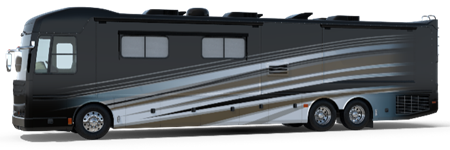 |
| Class B |  |
| Class C |  |
| Bus Conversion | 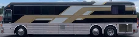 |
| Camper Van |  |
- Non-Motorized RV Examples (See Table 1600-2)
- Fifth Wheel (Fiver)
A trailer that connects to a hitch in a truck's bed. This is typically much larger than the other trailer types. - Travel TrailerRV trailer that connects to a large or small vehicle depending on the range of sizes that are available.
- Hybrid TrailerThis trailer has beds that pop-out similar to the pop-up/tent camper but large spaces like the Fifth Wheel and Travel Trailer above.
- Pop-Up/Tent CamperA camper with a roof that raises up and beds that slide out to provide more interior space. The camper folds down for travel and storage.
- Truck CamperThis camper is designed to slide into the bed of a pickup trick to create a motorized RV. Sizes are from small to large units that can be similar to or larger than a Class C motorized RV.
- Teardrop CamperAn ultralight, teardrop shaped travel trailer typically only holding a bed. The exterior may have a compartment that opens into a small kitchenette.
- Fifth Wheel (Fiver)
Table 1600-2: Non-Motorized RVs
| Fifth Wheel (Fiver) |  |
| Travel Trailer | 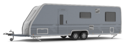 |
| Hybrid Trailer | 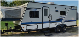 |
| Pop-Up / Tent Camper | 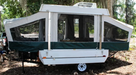 |
| Truck Camper | 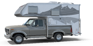 |
| Teardrop Camper |  |
Recreational Vehicle Space
An area of ground within a recreational vehicle park designated for the temporary accommodations of one recreational vehicle.
Reserve Strip
A strip of land (usually only a few feet wide) owned privately, and set aside around a subdivision in order to prevent access to adjacent property by way of subdivision streets.
Right-of-Way
Land opened, reserved or dedicated for a street, walk, drainage way or other public purposes. Street right-of-way shall mean any public right-of-way set aside for public travel which has been accepted for maintenance by the State of North Carolina or the Town of Indian Trail or Union County, if so authorized, or has been dedicated for public travel by the recording of a plat or a subdivision which has been approved or is subsequently approved by the Town of Indian Trail, or has otherwise been established as a public street prior to the adoption of this ordinance.
1620.190 Definitions - "S"
Screening (Visual)
A method by which a view of one site from another adjacent site is shielded, concealed, or hidden. Screening techniques include fences, walls, hedges, tree rows, berms, or other features.
Security Lighting
Means a light used either commercially or residentially for protection of goods or property and is designed and used to discourage crime and undesirable activity.
Semi Cutoff Fixture
An outdoor light fixture shielded or constructed in such a manner that it emits no more than 5% of its light above the horizontal plane of the fixture, and no more than 20% of its light ten (10) degrees below the horizontal plane of the fixture.
Setback
An open, unobstructed area that is required by this ordinance to be provided from the furthermost projection of a structure to the lot line of the lot on which the building is located. If the area to be set back is affronting or abutting a public and/or private street, then the area to be measured shall be from the ultimate right-of-way, except as may be otherwise indicated for the street in question in a recorded plat map, tract map, or a specific plan that has been adopted by the Town. Such measurement shall conform to the definition of ultimate right-of-way as indicated in this Section of this ordinance.
Setback, Exterior
A setback from a street which shall be measured, except where may be indicated by a specific recorded plat map, tract map, or a specific plan that has been adopted by the Town, from the ultimate right-of-way as indicated in this Section of this ordinance.
Setback, Front
A setback between a building and the front lot line of the lot on which the building is located, extending along the full length of the front lot line between the side lot lines. If the setback abuts or affronts a public and/or private street, then the setback shall be measured from the ultimate right-of-way of the street to the building itself. Such a measurement shall use the Definition of ultimate right-of-way as indicated in this Section of this Ordinance.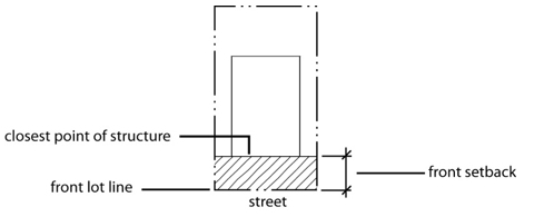
Setback, Interior
A setback from an interior (non-street) lot line. Such setbacks need not utilize the ultimate right-of-way definition provided in this Section of this Ordinance unless the setback abuts a public and/or private street.
Setback, Street Side
A setback from a street lot line on a corner lot. Such setbacks need not utilize the ultimate right-of-way definition in this Section of this Ordinance unless the setback abuts a public and/or private street.
Shielding
A design feature or a device that is applied to a luminaire to prevent its luminous output from being visible from selected locations or horizontal and/or vertical angles.
Shopping Center
A group of two (2) or more commercial or office uses designed as one unified entity under single ownership or control consisting of one or several buildings either attached or detached.
Short-Term Loan Service
Any business that loans money on a short-term basis to members of the general public as an element of its operation, including businesses offering title loans, payday loans, signature loans and small loans under North Carolina General Statutes, and other similar businesses. This does not include banks, savings and loan associations or credit unions licensed by appropriate State and Federal agencies, or a retail credit financing institution that is licensed under North Carolina General Statutes, or pawn brokers governed by North Carolina General Statutes.
Shrubs
Any self-supporting, woody plant of a species which normally grows to an overall height of less than 15 feet in the region.
Sight Triangle
The triangular area formed by a diagonal line connecting two points located on intersecting right-of-way lines, or a right-of-way line and the curb or edge of pavement or a private street or driveway, each point being 35 feet from the intersection, and the two intersecting right-of-way lines (or right-of-way line and curb cut).
Sign
Any object, display, or structure, or part thereof, situated outdoors, which is used to advertise, identify, display, direct, or attract attention to an object, person, institution, organization, business, product, service, event, or location by any means, including words, letters, figures, design, symbols, fixtures, colors, illumination, or projected images. The term “sign” does not include the flag or emblem of any nation, organization of nations, state, political subdivision thereof, or any fraternal, religious or civic organization; works of art which in no way identify a product or business; scoreboards located on athletic fields; or religious symbols.
Sign, Advertising
A sign, other than directional sign, which directs attention to or communicates information about a business, commodity, service, or event that exists or is conducted, sold, offered, maintained, or provided at a location other than the premises where the sign is located. Any advertising sign allowed under this Ordinance may display either a commercial or noncommercial copy.
Sign, Airborne
Any sign, including any moored blimp, gas balloon, or other inflatable element, whether or not intended to move in the wind, which is designed to inform or attract the attention of persons not on the premises on which it is located.
Sign, Animated
A sign with action, motion or color changes, including wind-activated devices, video screens, and including intermittent or sudden changes of light intensity, but not including signs defined as changeable copy signs or electronic message center signs.
Sign, Banner
A sign made of non-rigid material, possessing some characters or ornamentation, intended to be hung either with or without an enclosing framework, but not a flag or pennant.
Sign, Billboard
A permanently constructed sign structure composed of one or more large surfaces for permanent or changeable messages supported by one or more vertical posts and generally used for off-premises advertising.
Sign, Bulletin Board
A sign used to announce meetings or programs to be held on the premises of a church, school, auditorium, library, museum, community recreation center or similar noncommercial place or public assembly.
Sign, Campaign or Election, Political
A sign that advertises a candidate or issue to be voted on a definite Election Day.
Sign, Canopy or Awning
A sign attached to or painted or printed onto a canopy or awning. For the purposes of the Ordinance, the permitted size of a canopy or awning will be calculated on the basis of the size of the building wall to which the canopy is attached. It will, for measuring purposes, be considered a wall sign.
Sign, Changeable Copy
A sign designed so the copy can be changed while the display surface remains unchanged; includes such signs as manually or electronically changed reader boards and fuel price displays. Electronically changed reader boards do not include rapid changes in light intensity or blinking features. Light Emitting Diodes (LED) changeable copy signs may only be a Static Message Board with change in message limited to ten (10) minute intervals.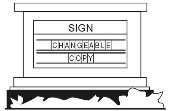
Sign, Construction
A sign placed at a construction site identifying or announcing the project or the name of the architect, engineer, financier, or others involved in the development of the project.
Sign, Directional
Any sign that provides on-site directional assistance for the convenience of the public, an on-site sign indicating the location exits, entrances, or parking.
Sign, Directory
A sign on which the names and locations of occupants or the use of a building or property is identified.
Sign, Electronic Message Center
A sign or component of a sign that uses changing lights of a single color to form a message or series of messages that are electronically programmed or modified by electronic processes.
Sign, Flashing
A sign that uses an intermittent or flashing light source or windblown and/or mechanical moved reflective material to attract attention.
Sign, Free-Standing
Any sign that is not affixed to a building and is securely and permanently mounted in the ground. Such sign may include a ground, pole, or monument sign.
Sign, Government
Any temporary or permanent sign erected and maintained for any government purposes other than signs placed on the premises of a publicly owned building, structure or other land use, designed to identify to the public such land use. Examples of government signs include speed limit signs, town limit signs, street name signs, and traffic signs. Conversely, a sign placed on a public building such as library, school, or public safety building which identifies said building, shall not be considered a government sign.
Sign, Ground Mounted
Any sign not attached to a building which extends from the ground or which has supports which places the bottom of the sign permanently mounted less than three (3) feet from the ground directed beneath the sign.
Sign, Identification
A sign which displays only the name, address, and/or crest, or insignia, trademark, occupation or profession of an occupant or the name of any building on the premises.
Sign, Incidental
A sign used in conjunction with equipment or functional elements for a use or operation. These shall include, but not limited to drive through window menu boards and signs on automatic teller machines, gas pumps, vending machines, or newspaper delivery boxes.
Sign, Instructional
An on-premises sign designed to guide vehicular and/or pedestrian traffic by using such words as “Entrance”, “Exit”, “Parking”, “One-Way”, or similar directional instruction, but not including any advertising message. The name or logo of the business or use to which the sign is giving direction may also be included on the sign.
Sign, Lighted
A sign illuminated only by light cast upon the sign from an external light source.
Sign, Logo
A sign used on limited access highways to direct motorists to nearby businesses and services.
Sign, Luminous
A sign internally lighted through the use of phosphorescent or luminescent paint or materials.
Sign, Monument
A nonmetallic sign in which the bottom of the sign is flush with the ground and the vertical dimension is greater than the horizontal dimension.
Sign, Nonconforming
A sign that, on the effective date of this ordinance, does not conform to one or more or the regulations set forth in this ordinance, particularly those contained in this Chapter.
Sign, Off-Premises
A sign that draws attention to or communicates information about a business, service, commodity, that exists or is conducted, sold, offered, maintained or provided at a location other than the premises where the sign is located.
Sign, On-Premises
A sign that draws attention to or communicates information about a business, service, commodity, accommodation, attraction, or other enterprise or activity that exists or is conducted, sold, offered, maintained or provided on the premises where the sign is located.
Sign, Pennant
Any lightweight material, whether or not containing a message or any kind, suspended from a rope, wire, string, or pole, usually in a series designed to move in the wind.
Sign, Pole
A sign whose face is suspended from a support arm at a right angle from a ground mounted pier, pillar, column, or pole. The face of such sign shall not be more than three (3) feet from the ground.
Sign, Portable
Any sign not permanently attached to the ground or other permanent structure, including those signs which may be transported to the site on wheels or a truck; signs constructed or as converted to an A-frame or sandwich board, T-frame sign; or umbrellas used for advertising purposes. Such sign, whether or not bolted to the ground, shall nonetheless be deemed to be a “portable sign”.
Sign, Projecting
Any sign other than a wall, awning, canopy, or marquee sign, which is affixed to a building and is supported only by the wall on which the sign is mounted.
Sign, Public Interest
A sign on private property that displays information pertinent to the safety or legal responsibilities of the general public such as “Warning” and “No Trespassing” signs.
Sign, Real Estate
Signs that are used to offer for sale, lease, or rent the premises upon which such sign is placed.
Sign, Roof
A sign erected or maintained in whole or in part upon or over the roof or parapet of a building.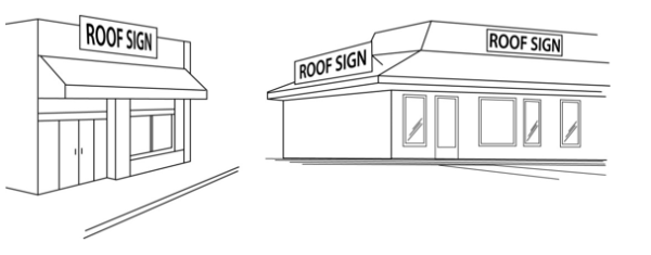
Sign, Sandwich Board
A portable A-frame sign constructed with two faces, which rest at an angle less than 45 degrees to each other.
Sign, Subdivision or Neighborhood Identification
A sign containing only the name of the subdivision or neighborhood in which the sign is located.
Sign, Temporary
A sign that is not permanently installed in the ground or affixed to any structure or building, and that is designed for short-term use or is used in connection with a special event expected to take place or be completed within a period of time as permitted in this chapter.
Sign, V-Shaped
Any sign which has two (2) faces that are not parallel, (not to include sandwich signs and "A" frame signs). A "V" shaped sign shall not have an included angle of not more than 45 degrees. Sign area shall be calculated by measuring a single face.
Sign, Vehicle
A motor vehicle or trailer containing a commercial message and regularly parked on the exterior side of any business and not customarily used in the operation of the business.
Sign, Wall
Any sign directly attached to an exterior wall of a building or dependent upon a building for its support with its exposed face parallel or approximately parallel to the plane of the building or structure on which it is placed. Signs directly painted on walls shall be considered wall signs.
Sign, Wind-Blown
A sign consisting of balloons, pennants or objects designed and fashioned in such a manner as to move when subjected to wind pressure.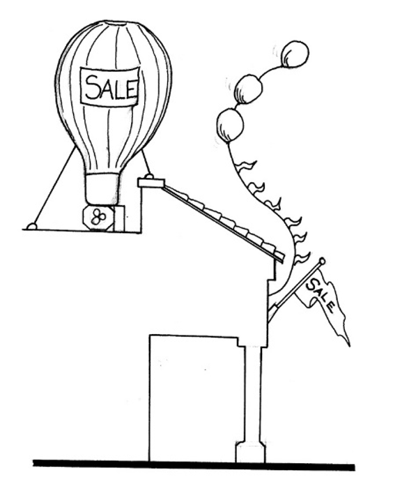
Site Plan
A drawing that shows all of the existing conditions of a specific area (the site) and all of the improvements and changes proposed to be made on the site. A site plan is the drawing required by the ordinance for certain new developments and certain additions and must contain all applicable information as specified in this.
Sleeping Unit
A room or space in which people sleep, which can also include permanent provisions for living, eating, and either sanitation or kitchen facilities but not both. Such rooms and spaces that are also part of a dwelling unit are not sleeping units. (2012 NC Building Code)
Small Maturing Tree
A tree whose height is less than 30 feet at maturity and meets the specifications of “American Standards for Nursery Stock” published by the American Association of Nurserymen.
Small Wind Energy System
A wind energy conversion system consisting of a wind turbine, a tower, and associated control or conversion electronics that has a maximum power of no more than 50kW and that is used primarily to reduce on-site consumption of utility power.
Specified Anatomical Areas
Less than completely and opaquely covered human genitals, pubic region, buttock, or female breast below a point immediately above the top of the areola; or human male genitals in a discernibly turgid state, even if completely and opaquely covered.
Specified Sexual Activities
Any of the following:
- human genitals in a state of sexual stimulation, arousal, or tumescence; or
- the fondling or other erotic touching of human genitals, pubic region, buttocks, anus, or female breasts; or
- sex acts, normal or perverted, actual or simulated, including intercourse, oral copulation or sodomy; or
- masturbation, actual or simulated; or
- masochism, erotic or sexually oriented torture, beating or the infliction of pain; or
- erotic or lewd touching, fondling, or other contact with an animal by a human being; or human excretion, urination, menstruation, vaginal or anal irrigation.
Stable, Private
A detached accessory building that has a roof and one or more sides that is used to house and shelter an equine or equines owned by the occupants of the premises or subdivision and not kept for remuneration, hire, or sale.
Stable, Public
A stable other than a private stable.
Stand
A group of trees of sufficiently uniform and/or complimentary species composition, age, and condition that they may be considered homogenous unit for management purposes.
Street
A public right-of-way that affords the principal means of vehicular access to abutting property.
Street Link
The segment of street between intersecting streets that have traffic control devices that interrupt traffic flow.
Street Tree
A tree planted within or adjacent to a public right-of-way as required by the town.
Street Tree Planting
The planted area within the front setback adjacent to a public or private street.
Street Width
The measured width of a street from edge of usable pavement to edge of usable pavement.
Structural Adequacy
A determination by the Town that the pavement cross section (or bridge design) is of sufficient depth and design to carry the increased traffic volume generated by the proposed development, including the heavy construction vehicles which will be present, without causing undue failure of the infrastructure.
Structure
Anything constructed or erected that requires location on the ground or is attached to something having a location on the ground, including but not limited to signs, but not including excepting pavement, utility poles, fences, and retaining walls.
Subdivider
Any person, firm, or corporation who subdivides or develops any land deemed to be a subdivision as herein defined.
Subdivision, Minor
Is a subdivision of land that does not involve any of the following:
- The creation of more than a total of five lots since 1978;
- The creation of any new public streets or street right-of-ways;
- The extension of water and sewer system facilities operated by the Union County Public Works Department;
- The installation of drainage improvements through one or more lots to serve one or more other lots;
- The installation of a private waste water plant or a private water supply system for more than one lot or building site.
Subdivision Plat
The final map or drawing, described in this ordinance, on which the developer’s plan of subdivision is presented for approval and that, if approved, is to be submitted to the County Recorder of Deeds for filing.
Sustainable
Capable of being continued with minimal negative long-term effects on the environment, the economy, and on residents’ quality of life.
Swale
A depression in the ground or a wide shallow ditch, usually grassed.
Swimming Pool, PrivateThis term shall mean any structure containing water used, or intended to be used, for swimming, recreational water games/sports, or recreational bathing/relaxation which is available in single-family detached residential districts only to the family and guests of the householder. Private swimming pools include in-ground swimming pools, and on-ground swimming pools, hot tubs and spas.
Swimming Pool, PublicThis pool is any swimming pool other than a private swimming pool.
1620.200 Definitions - "T"
Technical Review Committee
A committee of staff established to review technical aspects of subdivision proposals.
Temporary Portable Storage Container
A purpose-built, fully enclosed, box-like container that is designed for temporary storage of household goods and/or equipment. Such containers are uniquely designed for ease of loading to and from a transport vehicle.
Terminus Intersections
The intersection of the final connecting street, being evaluated for adequacy, with the street previously determined or considered adequate.
Threshold DVH (Design Hour Volume)
Maximum allowable design hourly volume (DHV) permitted of a given street link or intersection based on prevailing conditions.
Through Lot (Double Frontage)
A lot which fronts upon two parallel streets, and/or which fronts upon two streets which do not intersect at the boundaries of the lot.
Topping
The inappropriate removal or cutting back of major portions of a tree by any pruning practice resulting in more than 25% of the foliage and limbs being removed. This includes any pruning that leads to disfigurement of the normal shape of the tree. Topping is also referred to as “heading”, “stubbing” or “dehorning”.
Total Land Area
The land area equal to the developable area plus any on-site, open space or area devoted to stormwater detention or waste water treatment, but excludes all floodways from its calculations. Floodways may not be included into the calculations for density or total land area under any circumstances.
Tow Lot
The use of a site for temporary storage of motor vehicles for a period of not more than 30 days, not including temporary storage facilities for vehicles that are to be sold, rented, salvaged, dismantled, or repaired.
Town Recognized Event
A Town-recognized event is one that is in part or wholly sponsored by the Town, recognized by the Town, or proclaimed as a Town-recognized event by the Town Council. Such events shall include only those events listed on the Town recognized Event List as maintained by the Town Clerk. The Town-recognized Event List may be amended as need by the Town Council.
Tree Advisory Committee
A council-appointed committee that consists of seven (7) members from the Town of Indian Trail Planning and Zoning Board assisting in the planning and management of the Indian Trail community forest and the administration of the Tree Preservation and Protection and Landscaping Ordinances.
Tree Protection Zone or Critical Root Protection Zone
The critical root and tree protection zone is defined as the critical area above and below ground with a radius equivalent to the greater of the drip line, six feet, or a distance of 1.5 feet for every inch of trunk diameter as measured at breast height.
Tree Save Area
One or more areas of a site which includes existing trees and their tree protection zone. The purpose of a tree save area is to encourage the preservation of healthy clusters of trees or heritage trees.
Trees
Any self-supporting, woody plant of a species that normally grows to an overall minimum height of 15 feet in the region.
Trip Distribution
The method of assigning trips to street network based on projected travel origins and destinations.
Trip Generation
An analytical process that provides the relationship between land use and vehicle trip production. A one-way movement.
Turf Grass
A species of perennial grass grown as permanent lawns or for landscape purposes as distinguished from those species grown for agricultural or commercial seed purposes.
Typical Uses
See "Uses, Typical" for definition.
1620.210 Definitions - "U"
Ultimate Right-of-Way
The right-of-way shown as ultimate on an adopted Thoroughfare Plan, Comprehensive Plan, or the street rights-of-way shown within the boundary of a recorded tract map or other recorded parcel map. The latest adopted or recorded document in the above cases shall take precedence. If none of these exist, the ultimate right-of-way shall be considered the right-of-way required by the highway classification as shown on the Indian Trail Comprehensive Plan, Thoroughfare Plan, or by NCDOT standards. In all other instances, the ultimate right-of-way shall be considered to be the existing right-of-way, in the case of a private street, and the existing right-of-way, in the case of a public street, unless otherwise dedicated to NCDOT as existing or future right-of-way. All setbacks are to be measured from this right-of-way, unless otherwise indicated by NCDOT, the Indian Trail Thoroughfare Plan, the Indian Trail Comprehensive Plan, or other adopted or recorded plans or plats.
Up-Lighting
Lighting that is directed and aimed in such a manner as to shine light rays above the horizontal plane, such as the lighting of a building façade, church steeple, foliage, flagpole or sign.
Urban Forest
Trees or plants in the town.
Use
An activity carried on in a building, structure, or tract of land, including accessory uses that are subordinate in area, extent, and purpose to the principal use and that are customary adjuncts to the principal use.
Use Categories
Each use group is further divided into more specific “use categories.” use categories classify land uses and activities based on common functional, product, or physical characteristics. Characteristics include the type and amount of activity, the type of customers or residents, how goods or services are sold or delivered and site conditions.
Use Groups
This ordinance classifies land uses into 5 major groupings: “residential,” “public and civic,” “commercial,” “industrial” and “other.” These are referred to as “use groups.”
Uses, Typical
Typical uses cited in the description of use categories are not intended to be exclusive or restrictive.
1620.220 Definitions - "V"
Variance, Zoning
Relief from or variation of the zoning-related provisions of this ordinance, other than use regulations. Variances are requested through the Town Planning and Zoning Board in a quasi-judicial proceeding. See Chapter 380 Appeals and Variances for appeal requirements.
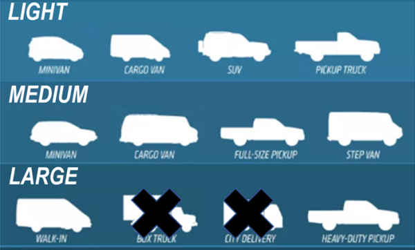
Vehicle, Commercial
Commercial vehicles are defined as Light, Medium or Large as follows:
- Light
Any vehicle designed or used for business purposes that has a gross vehicle weight rating (GVWR) of less than ten thousand (10,000) pounds and a cargo area/work platform (including any installed accessories such as ladder racks, cranes, compressors, hose reels, welders, etc.) that does not exceed the height of the cab of the vehicle. Cargo area/work platforms separate from the cab shall not exceed nine (9) feet in length (not to include step bumpers less than eighteen (18) inches in length). A pickup truck, sport utility vehicle, van, or similar vehicle may be considered a passenger vehicle if it is less than ten thousand (10,000) pounds gross vehicle weight rating (GVWR) and has only the original "showroom stock" body/bed. A camper shell, toolbox within the bed, or similar accessory equipment will not disqualify the vehicle as a passenger vehicle. - Medium
Any vehicle designed or used for business purposes that has a GVWR of less than fourteen thousand (14,000) pounds and does not exceed nine and one-half (9.5) feet in height (including any installed accessories such as ladder racks, cranes, compressors, hose reels, welders, etc.). Cargo area/work platform shall not exceed nine (9) feet in length (not to include step bumpers less than eighteen (18) inches in length). Also, any removal of the bed of the truck for commercial enhancements will be considered a large commercial vehicle or any improvement to a vehicle which primary purpose is not for the transportation of people. - Large
Any vehicle designed or used for business purposes that has a GVWR of fourteen thousand (14,000) pounds or more. Large commercial vehicles also include commercial vehicles with a GVWR of less than fourteen thousand (14,000) pounds if the height of the vehicle exceeds nine and one-half (9.5) feet (including any installed accessories such as ladder racks, cranes, compressors, hose reels, welders, etc.), or the length of the cargo area/work platform exceeds nine (9) feet (not to include step bumpers less than eighteen (18) inches in length).
Vertical Sight Distance
The length of street ahead of an object in the street, of specified height, visible to the driver while traversing a vertical curve.
Visibility or Sight Triangle
A triangular-shaped portion of land established at street and driveway intersections in which nothing is erected, placed, planted or allowed to grow in such a manner as to limit or obstruct the sight distance of motorists entering or exiting an intersection of streets or of a street and driveway. See figure below: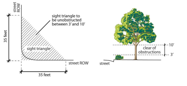
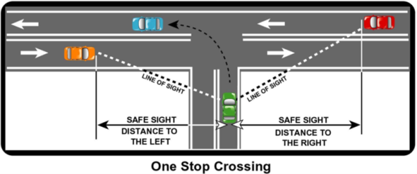
1620.230 Definitions - "W"
Wallpack Fixture
A lighting unit typically surface mounted to a vertical exterior building wall.
1620.240 Definitions - "X"
**RESERVED**
1620.250 Definitions - "Y"
Yard, Front
The actual yard that exists across the full width of the lot from the front lot line to the building line. See also “setback.”
Yard, Rear
The actual yard that exists across the full width of the lot between the rear lot line and the rear line of the principal building. See also “setback.”
Yard, Side
The actual yard that exists between the principal building and the adjacent side lot line extending entirely from the front lot line to the rear lot line. See also “setback.”
1620.260 Definitions - "Z"
Zero-Lot Line Development
A development that complies with the zero lot line regulations of this ordinance or the zero lot regulations in effect at the time the development was established.
1630.010 Use Groups
This ordinance classifies land uses into 5 major groupings: “residential,” “public and civic,” “commercial,” “industrial” and “other.” These are referred to as “use groups.”
1630.020 Use Categories
Each use group is further divided into more specific “use categories.” use categories classify land uses and activities based on common functional, product, or physical characteristics. Characteristics include the type and amount of activity, the type of customers or residents, how goods or services are sold or delivered and site conditions.
1630.030 Typical Uses
Typical uses cited in the description of use categories are not intended to be exclusive or restrictive.
1630.040 Determination Of Most Similar Use Category
When a specific use type cannot be readily classified into a use category or appears to fit into two or more use categories, the Community Development Director is authorized to determine the most similar, thus most appropriate, use category based on the following considerations:
- The actual or projected characteristics of the activity in relationship to the stated characteristics of each use type;
- The relative amount of site area or floor space and equipment devoted to the activity;
- Relative amounts of sales from each activity;
- The customer type for each activity;
- The relative number of employees in each activity;
- Hours of operation;
- Building and site arrangement;
- Vehicles used with the activity;
- The relative number of vehicle trips generated by the use;
- Signs;
- How the use advertises itself; and
- Whether the activity is likely to be found independent of the other activities on the site.
1630.050 Residential Use Group
The residential use group includes uses that provide living accommodations to one or more persons. The group includes two use categories: group living and household living.
- Group Living
Residential occupancy of a dwelling by other than a “household,” typically providing communal kitchen/dining facilities. Examples of group living uses include but are not limited to fraternities, sororities, convents, monasteries, nursing homes and the following specific use types:
- Group Home
A single dwelling occupied on a permanent basis by a group of unrelated persons. Group homes may also be occupied by paid staff and caregivers.
- Type 1: Family Home (Small) Means a home with support and supervisory personnel that provide room and board, personal care and habilitation services in a family environment for no more than six resident persons with disabilities.
- Type 2: Family Home (Large) Means a home with support and supervisory personnel that provide room and board, personal care and habilitation services in a family environment for more than six resident persons with disabilities.
- Nursing Home A residence which provides lodging, meals, nursing and other personal services for those who are unable to care for themselves or otherwise requires assistance for certain essential functions.
- Senior Housing A residential complex containing multifamily dwelling designed for and principally occupied by senior citizens. Such facilities may or may not include a common dining area but such facilities do not include institutional care such typically associated with nursing homes or senior life-care centers.
- Boarding House
A building, other than a hotel or motel, where lodging or individual rooms, or both are provided for compensation, whether directly or indirectly, to more than four (4) unrelated persons for periods in excess of 30 days.
- Group Home
A single dwelling occupied on a permanent basis by a group of unrelated persons. Group homes may also be occupied by paid staff and caregivers.
1630.060 Household Living Category
Residential occupancy of a dwelling unit by a household with tenancy arranged on a monthly or longer basis and arranged through short-term rentals. Household living occurs in the following types and uses of residential buildings:
- Detached House A building containing one dwelling unit located on a single lot with private yards on all sides.
- Zero Lot Line House A building containing one dwelling unit located on a single lot. The building is shifted to one side of the lot so that there is a more usable side yard on one side of the house and very little or no private yard on the other side.
- Attached House A building containing multiple dwelling units, each located on its own lot with a common or abutting wall along shared lot lines. Each dwelling unit has its own external entrance.
- Two-Unit House
A building containing 2 dwelling units, both of which are located on a single lot or parcel (also referred to as a “duplex” or “two-flat”). The dwelling units are attached and may be located on separate floors or side-by-side.
- Multi-Unit House A building containing 3 to 8 dwelling units located on a single lot. Multi-unit houses appear as large detached houses and have only one entrance visible from the street.
- Multiplex A building containing 3 to 8 dwelling units, each of which has its own external entrance.
- Apartment/Condo A building containing 3 or more dwelling units that share common walls and/or common floors/ceilings. Apartment/condo buildings are typically served by one or more common building entrances.
- Manufactured Home / Mobile Home
A building unit structure or assembly of closed construction that is fabricated in an off-site facility. The structure is constructed in conformance with the federal construction and safety standards established by the Secretary of Housing and Urban Development pursuant to the “Manufactured Housing Construction and Safety Standards Act of 1974,” 42 U.S.C. §§ 5401, 5403 and that has a permanent label or tag affixed to it, as specified in 42 U.S.C. § 5415, certifying compliance with all applicable federal construction and safety standards. Note that a manufactured home may be referred to as a “mobile home”, but a mobile home must meet this definition to be referred to as a “manufactured home”. The term manufactured home shall not include the terms travel trailers, motor homes, travel and/or motorized coaches, pick-up coaches, camping trailers, recreational vehicles, pop-up campers, prefabricated and modular structures and/or homes. Pursuant to G.S. 143-145, a manufactured home includes the following:
- Transportable in one or more sections where the traveling mode eight (8) body feet or more in width, or 40 body feet or more in length, or, when erected on site, is 320 or more square feet.
- Built on a permanent chassis.
- Designed to be used as a dwelling.
- With or without a permanent foundation when connected to the required utilities, including the plumbing, heating, air conditioning and electrical systems contained therein.
- "Manufactured home" also encompasses double-wide manufactured homes, which is two or more portable manufactured housing units designed for transportation on their own chassis that connect on site for placement on a temporary or semipermanent foundation having a measurement of over 32 feet in length and over eight feet in width.
- Transportable in one or more sections where the traveling mode eight (8) body feet or more in width, or 40 body feet or more in length, or, when erected on site, is 320 or more square feet.
- Manufactured Home / Mobile Home, Class A
A manufactured home meeting or exceeding the United States Department of Housing and Urban Development standards (all manufactured homes built after June 14, 1976), which is of multi-sectional or double-wide design and meets the appearance criteria provided in Section 1310.050 Manufactured Housing Units On Individual Lots. - Manufactured Home / Mobile Home, Class B A manufactured home constructed to meet or exceed United States Department of Housing and Urban Development code requirements for manufactured homes, and which meets any applicable requirements in Section 1310.050 Manufactured Housing Units On Individual Lots.
- Manufactured Home / Mobile Home Park Any plot of ground containing more than one mobile home space, regardless of whether or not a charge is made for the occupation of such spaces.
- Modular Home A dwelling unit constructed in accordance with the standards set forth in the North Carolina State Building Code and is made of components substantially assembled in a manufacturing plant and transported to a lot location site for final assembly on a permanent foundation. This is to be done in addition with also meeting or exceeding federal HUD requirements for these types of homes.
- Temporary Family Health Care Structure
A transportable residential structure providing an environment facilitating a caregiver's provision of care for a mentally or physically impaired person that (i) is primarily assembled at a location other than its site of installation, (ii) is limited to one occupant who shall be the mentally or physically impaired person, (iii) has no more than 300 gross square feet, and (iv) complies with applicable provisions of the State Building Code and G.S. 143-139.1(b). Placing the temporary family health care structure on a permanent foundation shall not be required or permitted. - Short-Term Rental (Whole House)
A house that can be used for overnight lodging accommodations that is provided to renters for no longer than 30 days for compensation.
1630.070 Public And Civic Use Group
The public and civic use group includes uses that provide public or quasi-public services. The public and civic use group includes the following use categories:
- College/University Colleges and other institutions of higher learning that offer courses of general or specialized study leading to a degree. They are certified by the state or by a recognized accrediting agency. Colleges tend to be in campus-like settings or on multiple blocks. Examples include universities, liberal arts colleges, community colleges, nursing and medical schools not accessory to a hospital, conservatories and seminaries.
- Day Care
Uses providing care, protection and supervision for children or adults with physical or mental disabilities on a regular basis away from their primary residence for less than 24 hours per day. There are 3 types of day care:
- Family Child Care Home Day care, provided within a dwelling unit, where, at any one time, more than two children, but less than nine children, receive child care. Of the children present at any one time in a family child care home, no more than five children shall be preschool‑aged, including the operator's own preschool‑age children.
- Child Care Center A child care center is an arrangement where, at any one time, there are three or more preschool age children or nine or more school age children receiving child care.
- Adult Day Care Home A facility where an individual, agency or organization provides supervision or care in a home-like environment for a maximum of six (6) adults in need of care because of physical or mental disability in a place other than their usual place of abode.
- Adult Day Care Center A facility where an individual, agency or organization provides supervision or care during the day time for more than six adults in need of care because of physical or mental disability in a place other than their usual place of abode.
- Detention and Correctional Facilities Facilities for the judicially required detention or incarceration of people. Inmates and detainees are under 24-hour supervision by peace officers, except when on an approved leave. Examples include prisons, jails, probation centers and juvenile detention homes.
- Hospital Uses providing medical or surgical care to patients and offering inpatient (overnight) care.
- Library/Cultural Exhibits Museum-like preservation and exhibition of objects in one or more of the arts and sciences, gallery exhibition of works of art, or library collection of books, manuscripts, etc., for study and reading.
- Park/Recreation Recreational, social, or multi-purpose uses associated with public parks, public open spaces, public community centers, public play fields, public or private golf courses, or other public recreation areas or buildings.
- Religious Assembly Religious services involving public assembly such as customarily occur in synagogues, temples, mosques and churches.
- Safety Services Public safety services that provide fire, police or life protection, together with the incidental storage and maintenance of necessary vehicles. Typical uses include fire stations, police stations and ambulance services.
- School Public and private schools at the primary, elementary, junior high, or high school level that provide state-mandated basic education.
- Utilities and Services
- Minor, Basic Infrastructure services that need to be located in area where the service is provided. Minor utilities and services generally do not have regular employees at the site and typically have few if any impacts on surrounding areas. Typical uses include water and sewer pump stations; small/minor water towers and reservoirs; small/minor electrical substations; water conveyance systems; stormwater facilities and conveyance systems; telephone switching equipment and emergency communication broadcast facilities.
- Major Infrastructure services that typically have substantial land-use impacts on surrounding areas and/or serve a larger regional or town-wide area. Typical uses include, but are not limited to, water and waste water treatment facilities, major water storage facilities and/or elevated tanks, and major electrical substations.
Commentary: Major utilities and services do not include “waste-related uses.”
1630.080 Use Groups And Categories
The commercial use group includes uses that provide a business service or involve the selling, leasing or renting of merchandise to the general public. The commercial use group includes the following use categories.
- ABC Stores An establishment that specializes in the sale and distribution of alcoholic beverages as a retail use, provided that such establishments meet all of the requirements and standards of Chapter 18B of the North Carolina General Statutes, the State of North Carolina ABC Commission, any local ABC Board in the jurisdiction where such an establishment will be placed, and any other appropriate local and/or state regulations or ordinances.
- Adult Arcade Any place or establishment operated for commercial gain that invites or permits the public to view adult material through coin-operated devices or electronically or mechanically controlled motion picture machines, projectors, video or disc players that show images to persons within a booth or small theater where the images so displayed are distinguished or characterized by the depiction or description of specified sexual activities or specified anatomical areas.
- Adult Bookstore or Adult Video Store
An establishment that sells, offers for sale, or rents adult material for commercial gain and that meets one of the following two criteria:
- More than 10% of the gross public floor area is devoted to adult material.
- More than 10% of the stock in trade consists of adult material.
- Adult Entertainment An adult club, adult juice bar, adult dancing establishment, adult theater or other commercial establishment where any employee, operator, or owner exposes his/her specified anatomical area for viewing by patrons. This may include massage establishments, salons, modeling studios, or lingerie studios where employees, operators, owners, or patrons expose his/her specified anatomical areas.
- Adult Material
Any one or more of the following, regardless of whether it is new or used:
- books, magazines, periodicals, or other printed matter; photographs, films, motion pictures, video cassettes, slides, or other representations; recordings, other audio matter; and novelties or devices; any of which have, as their dominant theme, subject matter that depicts, exhibits, illustrates, or otherwise graphically describes specified sexual activities or specified anatomical areas; or
- instruments, novelties, devices, or paraphernalia that are designed for use in connection with specified sexual activities.
- Adult Modeling Studio Any place where a person appears in a manner that displays specified anatomical areas in order that that person can be observed, sketched, drawn, painted, sculpted, photographed, or similarly depicted by other persons for any form of consideration. Adult modeling studio shall not include a proprietary school licensed by the State of North Carolina or a college, junior college, or university supported entirely or in part by public taxation; a private college or university which maintains and operates educational programs in which credits are transferable to a college, junior college, or university supported entirely or partly by taxation or university supported entirely or partly by taxation; or a studio or establishment where there is no sign visible from any public street advertising or otherwise indicating the availability of nude or semi-nude persons who expose specified anatomical areas for viewing and where the participation in drawing, painting, sculpting, or photography activities is by students who enroll at least three days in advance of the class.
- Adult Motel A hotel, motel, or similar commercial establishment that offers accommodations to the public, for any form of consideration, and provides patrons with closed-circuit television transmissions, films, motion pictures, video cassettes, slides, or other photographic reproductions that depict or describe specified sexual activities and that has a sign visible from any public street that advertises the availability of this type of material to guest or patrons.
- Adult Motion Picture Theater A commercial establishment where, for any form of consideration, films, motion pictures, video cassettes, slides, or similar photographic reproductions are regularly shown as one of its principal business purposes that depict or describe specified sexual activities and/or specified anatomical areas.
- Adult Theater A theater, concert hall, auditorium, or similar commercial establishment which regularly features, exhibits, or displays, as one of its principal business purposes, persons who expose specified anatomical areas or where live entertainment acts involve performances that expose or depict specified anatomical areas and/or specified sexual activities.
- Sexual Encounter Center A business or commercial enterprise that, as one of its principal business purposes, offers for any form of consideration physical contact in the form of wrestling or tumbling between persons of the opposite sex, or activities between male and female persons and/or persons of the same sex when one or more of the persons exposes specified anatomical areas.
- Amusement Arcade
A building or part of a building containing four (4) or more video, pinball, or similar player-operated amusement devices, in any combination, for commercial use. - Animal Services
The following are animal services use types:
- Animal Sales and Grooming Sales and grooming of dogs, cats and similar small animals. Typical uses include pet stores, dog bathing and clipping salons and pet grooming shops.
- Animal Shelter and Boarding Kennel Animal shelters and kennel services for dogs, cats and small animals. Typical uses include boarding kennels, dog training centers and animal rescue shelters.
- Animal Hospital (Indoor Kennels) A place where animals are given medical or surgical treatment and the boarding of animals is incidental to the hospital use. All facilities associated with an animal hospital shall be located indoors.
- Animal Hospital (Outdoor Kennels)
A place where animals are given medical or surgical treatment, and the boarding of animals is incidental to the hospital use. Facilities may be located outdoors and may include, but not be limited to kennels and training/exercise areas. - Animal Foster Care A residence in which the individual is caring with food, water and shelter for no more than six (6) dogs or cats total until a permanent home can be found for the animals. More than six (6) dogs and/or cats total in an allowed residential use shall constitute an Animal Shelter.
- Apiaries
A place where bee colonies are kept. - Artist Work or Sales Space Floor space devoted to the production, showing, or sale of art. Typical uses include art galleries and artist studios, but not including art museums. Art museums are classified in the “Libraries and Cultural Exhibits” use category.
- Building Maintenance Services Provision of maintenance and custodial services to commercial and industrial establishments. Typical uses include janitorial, landscape maintenance and window cleaning services. Also includes exterminator services for residential, commercial or industrial applications.
- Business Equipment Sales and Services Sales, rental, or repair of office, professional and service equipment and supplies to companies rather than to individuals. Excludes automotive and heavy equipment sales or service. Typical uses include office equipment and supply firms, small business machine repair shops and hotel equipment and supply firms.
- Business Support Services Provision of clerical, employment, protective, or minor processing services to firms rather than individuals. Typical uses include employment agencies, telephone answering services, blueprint services, and business or trade schools. Business or trades schools that involve outdoor storage or manufacturing processes are not considered business support services but rather are to be classified in an Industrial use group category.
- Communication Service Establishments Broadcasting and other information relay services accomplished through use of electronic and telephonic mechanisms. Excludes services classified as “major utilities and services” and “Minor Utilities.” Typical uses include recording studios, television and radio studios, telecommunication service centers and telegraph service offices.
- Eating and Drinking Establishments Provision of prepared food or beverages for on- or off-premises consumption. Typical uses include restaurants, restaurants with alcohol service, or private clubs.
- Entertainment and Spectator Sports
Provision of cultural, entertainment, athletic and other events to spectators. The following are spectator sports and entertainment use types:
- Small Venue Entertainment and spectator sports establishments with a capacity of no more than 149 persons. Typical uses include small theaters and meeting or banquet halls.
- Medium Venue Entertainment and spectator sports establishments with a capacity of more than 149 and fewer than 500 persons. Typical uses include theaters and meeting or banquet halls.
- Large Venue Entertainment and spectator sports establishments with a capacity of 1,000 persons or more. Typical uses include large theaters, cinemas and meeting or banquet halls.
- Financial Services
Financial or securities brokerage services. Typical uses include banks, savings and loans, credit unions, consumer investment businesses, pawn shops and short-term loan services.
- Short-Term Loan Services Businesses that loan money on a short-term basis to the general public as an element of their operation, including businesses offering title loans, payday loans, signature loans and small loans under North Carolina General Statutes, and other similar businesses, but not including banks, savings and loan associations or credit unions that are licensed by appropriate state and federal agencies, or retail credit financing institutions that are licensed North Carolina General Statutes, or pawn shops as governed by Chapter 91A-1 of the North Carolina General Statutes.
- Pawn Shops Businesses that lend money on the security of pledged goods or that is engaged in the business of purchasing tangible personal property on condition that it may be redeemed or repurchased by the seller for a fixed price within a fixed period of time. Pawnshops and pawnbrokers are further governed by Chapter 91A-1 of the North Carolina General Statutes.
- Food and Beverage Retail Sales Retail sale of food and beverages for home consumption. Typical uses include groceries, specialty food stores and wine shops.
- Funeral and Internment Services
Provision of services involving the care, preparation or disposition of human dead. The following are funeral and interment services use types:
- Cemetery/Mausoleum/Columbarium Land or facilities used for burial of the dead.
- Cremating Crematory services involving the purification and reduction of the human body by fire. Typical uses include crematories and crematoriums.
- Undertaking Undertaking services such as preparing the dead for burial and arranging and managing funerals. Typical uses include funeral homes and mortuaries.
- Gasoline and Fuel Sales A building or portion thereof used for offering for sale at retail to the public, fuels, oils and accessories for motor vehicles, where repair service and automobile washing is incidental, where no storage or parking space is offered for rent and where no motor vehicles or boats are offered for sale or rent.
- Lodging
Provision of lodging services on a temporary basis with incidental food, drink and other sales and services intended for the convenience of guests. The following are lodging use types:
- Bed and Breakfast An owner- or manager-occupied detached house that contains 6 or fewer guestrooms for short-term lodging and in which the only meal provided to guests is breakfast. For the purposes of this definition, a guest is a person who rents a room in a bed and breakfast establishment for no more than 30 consecutive days.
- Hotel/Motel An establishment, other than a detached house, in which short-term lodging is offered for compensation and that may or may not include the service of one or more meals to guests. Typical uses include hotels, motels and boarding houses.
- Medical Service Personal health services including prevention, diagnosis and treatment, rehabilitation services provided by physicians, dentists, nurses and other health personnel and medical testing and analysis services. Typical uses include medical and dental offices, medical/dental laboratories, health maintenance organizations and government-operated health centers. Excludes use types more specifically classified, such as hospitals.
- Office Professional, governmental, executive, management or administrative offices of private organizations or government agencies. Typical uses include government offices, administrative offices, legal offices and architectural firms.
- Personal Improvement Service
Informational, instructional, personal improvement and similar services of a nonprofessional nature. Typical uses include hair salons, barber shops, beauty shops, nail salons, tattoo parlors, fortune telling studios, health clubs, yoga or dance studios, driving schools and martial arts studios.
- Body Art Service Provision of any of the following procedures: body piercing, tattooing, cosmetic tattooing, branding and scarification. This definition does not include practices that are considered medical procedures by the North Carolina State Medical Board, which services may not be performed in a body art service establishment.
- Fortune Telling Service An establishment engaged in or that professes to foretell future or past events or that is engaged in the practice of palmistry (the art or practice of reading a person’s character or future from the lines on the palms of hands).
- Repair and Laundry Services, Consumer Provision of repair, dry cleaning or laundry services to individuals and households, but not to firms. Excludes vehicle and equipment repair. Typical uses include laundry/dry cleaning drop-off stations (with no dry cleaning on the premises), hand laundries, appliance repair shops, locksmiths, shoe and apparel repair and musical instrument repair.
- Retail Category
Businesses involved in the sale, lease or rent of new or used products, merchandise to consumers. Typical uses include drug stores, grocery stores, department stores, apparel stores and a host of other stores and shops offering goods and merchandise for sale to the public. The following are specific retails sales use types.
- Second Hand Thrift/Consignment Sales The retail sale of mostly previously used merchandise to the general public such as clothing, furniture, small appliances, household goods, sporting goods, recreation equipment, or other similar merchandise not considered to be antique. Second Hand Thrift/Consignment Sales uses may operate as for-profit businesses or be associated with a nonprofit charitable organization and are commonly referred to as consignment stores, thrift stores, second hand stores, and vintage stores. This definition specifically excludes antique shops, pawnshops, flea markets, firearms shops, and other land uses that are more specifically identified within UDO Chapter 570.
- Antique Shops The retail sale of mostly previously used merchandise to the general public that is deemed to have collectible value and is at least 50 years of age. This definition specifically excludes Second Hand Thrift/Consignment Sales uses.
- Florist (Flower Shop)
Establishments primarily engaged in the arrangement and retail sale of cut flowers, small plants, cards, small gifts, and other similar items. - Retail Sales, Accessory (including vending)
Accessory retail uses include shops or stands within the primary structure or on the property that is secondary to the primary building and the primary use. Examples of such uses may include hospital cafeterias; magazine/newspaper stand; coffee shops; commercial electric vehicle charging stations; and retail package pickup lockers such as an Amazon Hub. Accessory retail uses may be conducted for the general public as well as for the convenience of the employees, patients, patrons, students or visitors. Such retail use shall be reviewed and allowed where applicable in the Table of Permitted Uses in Section 570.010.
- Sports and Recreation, Participant Provision of sports or recreation primarily by and for participants. (Spectators would be incidental and on a nonrecurring basis). Examples include bowling alleys, skating rinks, billiard parlors driving ranges and miniature golf courses.
- Vehicle Sales and Service
Sales of motor vehicles or services related to motor vehicles or the sale of automobile supplies such as vehicle parts. The following are vehicle sales and service use types:
- Car Wash/Cleaning Service A building or site containing facilities for washing automobiles. It may use automatic production line methods—a chain conveyor, blower, steam cleaning device, or other mechanical device—or it may provide space, water and equipment for hand washing, cleaning or detailing of automobiles, whether by the customer or the operator.
- Heavy Equipment Sales/Rentals
- Retail – Involves sales and /or rental directly from the premises of heavy construction equipment, trucks and aircraft, together with incidental maintenance. Typical uses include heavy construction equipment dealers and tractor trailer sales.
- Wholesale – Involves sales and/or rental not conducted directly from the premises of heavy construction equipment, trucks or aircraft, involving no incidental on-site maintenance, outdoor display and/or storage involved with the use. Typical uses include business-to-business distributorships and other similar wholesaling uses.
- Light Equipment Sales and Rentals
- Retail – Involves sales and /or rental directly from the premises of autos, noncommercial trucks, motorcycles, trailers with less than 10,000 lbs. gross cargo weight, recreational vehicles and boat dealers, together with incidental maintenance. Typical uses include automobile and boat dealers, car rental agencies and recreational vehicle sales and rental agencies.
- Wholesale – Involves sales and/or rental not conducted directly from the premises of autos, noncommercial trucks, motorcycles, trailers with less than 10,000 lbs. gross cargo weight, recreational vehicles and boat dealers, with no incidental on-site maintenance, outdoor display and/or storage involved with the use. Typical uses include business-to-business distributorships and other similar wholesaling uses.
- Motor Vehicle Repair
An establishment primarily engaged in maintenance, repair, servicing, or painting of motor vehicles.
- Limited Motor Vehicle Repair
Either of the following:
- A vehicle repair establishment that provides lubrication and/or checking, changing, or additions of those fluids and filters necessary to the maintenance of a vehicle. Customers generally wait in the car or at the establishment while the service is performed. Examples include quick lube services.
- A vehicle repair establishment that provides replacement of any passenger vehicle part or repair of any passenger vehicle part that does not involve body work or painting or require removal of the engine head or pan, engine transmission or differential. Examples include tire, muffler and transmission shops.
- General Motor Vehicle Repair Any vehicle repair activity other than “minor vehicle servicing” or “minor vehicle repair.” Examples include repair or servicing of commercial vehicles or heavy equipment or body work, painting, or major repairs to passenger vehicles.
- Limited Motor Vehicle Repair
Either of the following:
- Vehicle Storage and Towing Storage of operating motor vehicles or vehicle towing services. Typical uses include towing services, private parking lots, tow-aways, impound yards and fleet storage yards. This category will include storage yards for boats of recreational vehicles.
1630.090 Industrial Use Group
The industrial use group includes uses that produce goods from extracted materials or from recyclable or previously prepared materials, including the design, storage and handling of these products and the materials from which they are produced. It also includes uses that store or distribute materials or goods in large quantities. The industrial use group includes the following use categories:
- Junk/Salvage Yard An open area where waste or scrap materials are bought, sold, exchanged, stored, baled, packed, disassembled, or handled, including but not limited to scrap iron and other metals, paper, rags, rubber tires and bottles. A junk or salvage yard includes an auto wrecking yard, but does not include waste-related uses or recycling facilities.
- Manufacturing, Production, and Industrial Services
- Artisan Production On-site production of goods by hand manufacturing, involving the use of hand tools and small-scale, light mechanical equipment. Typical uses include woodworking and cabinet shops, ceramic studios, jewelry manufacturing and similar types of arts and crafts or very small-scale manufacturing uses that have no negative external impacts on surrounding properties.
- Limited Manufacturing of finished parts or products, primarily from previously prepared materials. Typical uses include: catering establishments, printing and related support activities; machinery manufacturing; food manufacturing; computer and electronic product manufacturing/assembly; electrical equipment, appliance, component manufacturing/assembly; furniture and related product manufacturing/assembly; and other manufacturing and production establishments that typically have very few, if any, negative external impacts on surrounding properties.
- General
- Manufacturing of finished or unfinished products, primarily from extracted or raw materials, or recycled or secondary materials, or bulk storage and handling of such products and materials. Typical uses include: textile mills; textile product mills; apparel manufacturing; leather and allied product manufacturing; wood product manufacturing; paper manufacturing; chemical manufacturing; plastics and rubber products manufacturing; nonmetallic mineral product manufacturing; transportation equipment manufacturing; primary metal manufacturing; and fabricated metal product manufacturing.
- Industrial service firms engaged in the repair or servicing of industrial or commercial machinery, equipment, products or by-products. Typical uses include: welding shops; machine shops; industrial tool repair; fuel oil distributors; solid fuel yards; laundry, dry-cleaning and carpet cleaning plants; and photofinishing laboratories. Excludes uses classified as “repair or laundry services.”
- Intensive Manufacturing of acetylene, cement, lime, gypsum or plaster-of-Paris, chlorine, corrosive acid or fertilizer, insecticides, disinfectants, poisons, explosives, paint, lacquer, varnish, petroleum products, coal products, plastic and synthetic resins and radioactive materials. Also includes smelting, animal slaughtering and oil refining.
- Mining/Excavation Mining or extraction of mineral or aggregate resources from the ground for off-site use. Examples include quarrying or dredging for sand, gravel or other aggregate materials; mining; and oil and gas drilling.
- Open Storage
See definition for "Open Storage" in Section 1620.150, Definitions - "O". - Recycling Service
Any building, portion of building or area in which recyclable material is collected, stored, or processed for the purpose of marketing the material for use as raw material in the manufacturing process of new, reused or reconstituted products.
- Limited, Indoors A recycling facility in which recyclable materials are temporarily stored or collected, or processed by manual separation. (Note: consumer-oriented collection boxes for newspapers, cans and glass items are considered an accessory use and may be allowed in any zoning district.)
- General A recycling facility that, in addition to any activity permitted as part of a limited recycling service, engages in processing of recyclable materials such as cleaning, bundling, compacting or packing of recyclable materials. This category includes facilities that operate principally indoors but may have accessory outdoor operations.
- Residential Storage Warehouses Storage or warehousing service within a building for individuals to store personal effects and for businesses to store materials for operation of an industrial or commercial enterprise elsewhere. Incidental uses in a residential storage warehouse may include the repair and maintenance of stored materials by the tenant; but in no case may storage spaces in a residential storage warehouse facility function as an independent retail, wholesale, business, or service use. Spaces may not be used for workshops, hobby shops, manufacturing, or similar uses. Human occupancy is limited to that required to transport, arrange and maintain stored materials.
- Warehousing, Wholesaling, and Freight Movement Storage, wholesale sales and distribution of materials and equipment. Typical uses include storage warehouses, moving and storage firms, trucking or cartage operations, truck staging or storage areas, wholesale sales of materials and equipment to parties other than the general public.
- Waste-Related Use Uses that receive solid or liquid wastes or recyclable material from others for transfer to another location and uses that collect or compact sanitary wastes or recyclable material. This may include facilities that manufacture or produce goods or energy from waste materials. This category includes resource recovery facilities, waste transfer stations, and compacting and shipping facilities.
- Flex Space - Light Industrial
Individual units in a building or portion thereof that is used and/or easily converted to a mix of primary uses for warehouse, distribution, laboratory, and/or light manufacturing space. The remaining portion of each unit is accessory, supporting retail and/or office space. Fewer customers come to the site than at a retail flex space. - Flex Space - Retail
Individual units in a building or portion thereof that is used and/or easily converted to a mix of primary uses for office, retail sales, showroom, and/or wholesale sales. The remaining portion of of each unit is accessory, supporting warehouse, and/or distribution space. More customers come to the site than at a light industrial flex space.
1630.100 Other Use Group
The “other” use group includes the following:
- Agriculture, Crop The use of land for the production of row crops, field crops, tree crops; timber, bees, apiary products, or fur-bearing animals.
- Agriculture, Animal The feeding, breeding, raising or holding of cattle, swine, poultry or other livestock, whether held in a confinement area or open pasture.
- Breweries, Distilleries, and Wineries (including taproom and taste room)
- Breweries (including micro breweries and cideries) An establishment, whether as a principal or accessory use, which manufactures or produces beer regardless of alcohol content.
- Distillery (including micro-distillery) An establishment, whether as principal or accessory use, which manufactures or produces, distilled spirits.
- Winery (including vineyard) An establishment, whether as a principal or accessory use, which manufactures or produces wine or sparkling wine.
- Outdoor Advertising The use of a site for the placement of off-premise signs.
- Taproom or Taste Room An area maintained predominately for the purpose of tasting, selling and consumption of the alcohol beverages manufactured on the premises or at a production facility of an associated use, including the sale of take home containers such as kegs, bottles and cans as may be allowed under Federal, State and County Law.
- Wireless Communication Antenna and Tower
Facilities related to the use of the radio spectrum for the purposes of transmitting or receiving radio signals, and may include, but are not limited to radio towers, television towers, telephone exchanges, micro-wave relay towers, telephone transmission equipment buildings, and commercial mobile radio service facilities. The wireless communication antenna and tower category includes all associated equipment unless the written context clearly indicates otherwise. The term associated equipment may include, but is not limited to equipment shelter or platform, lighting, monopole tower, mounting hardware, and supporting electrical or mechanical equipment.
- Co-located wireless facility A wireless communication antenna that is attached to an existing tower or to an existing building or structure including, but not limited to a church, water tower, clock tower, sign, telephone pole or similar structure.
- Free-standing facility A new tower, monopole, or other unattached structure erected to support wireless communication antennas and connecting appurtenances.
- Guyed tower
A communication tower or telecommunication tower that is supported in whole or part by guy wires or cables and ground anchors rather than by the superstructure of the tower itself.
Figure 1600-1: Tower with guy wires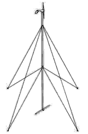
- Lattice tower
A three or four sided structure with an open framework made of metal or similar material overlapped or overlaid in a regular, usually crisscross pattern.
Figure 1600-2: Lattice Tower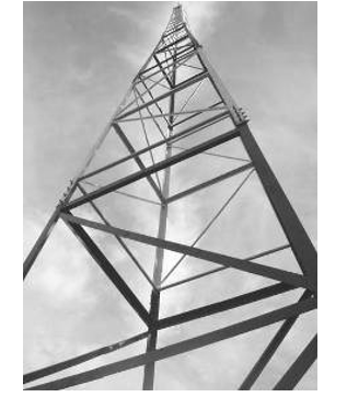
- Stealth wireless communication facility
A communication tower designed and installed in a manner such that the antenna, tower or pole, and associated equipment are disguised or hidden so as to eliminate the visual impact of the tower to the casual observer. Stealth towers and facilities must be built in an aesthetically and architecturally appropriate manner with regards to an existing structure or immediate environment in which the communication tower is located. Examples include, but are not limited to, church steeples, bell towers, clock towers, flag poles, fake trees, and chimneys.
Figure 1600-3: Samples of Stealth Towers
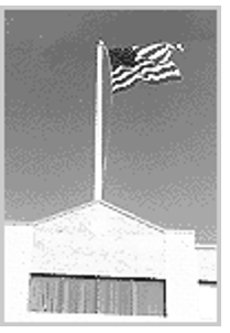
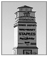
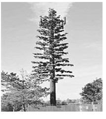
1640.010 Lot Size
The following rules apply when measuring compliance with and interpreting exceptions to applicable lot size standards.
- Lot Area Lot area refers to the total land area contained within the lot lines of a lot.
- Lot Area per Unit
Lot area per unit is a measure of “net” residential density and refers to the amount of lot area required for each dwelling unit on the subject lot. For example, if a minimum lot-area-per-unit standard of 4,000 square feet is applied to 8,000 square foot lot, a maximum of 2 dwelling units would be allowed on the property.
Commentary: Lot area per unit represents a maximum density standard; it is not a guarantee of density. Other factors may affect the total achievable density of an individual property. - Lot Frontage Lot frontage is measured between side lot lines along the front lot line abutting a street. Lot frontage requirements do not apply to lots abutting the bulb end of a cul-de-sac.
- Lot Width Lot width is measured between side lot lines along the front building line.
1640.020 Site
The following rules apply when measuring compliance with and interpreting exceptions to applicable site-related standards.
- Site Area Site area refers to the total gross land area of a development site.
- Open Space Open space refers to the total gross land area dedicated or otherwise set aside and protected as permanent open space. See Sec. 1110.060F
- Site Area per Unit Site area per unit is a measure of “gross” residential density and refers to the amount of site area required for each dwelling unit on the subject lot. For example, if a minimum site-area-per-unit standard of 10,000 square feet is applied to a site with a gross area of one acre (43,560 square feet), a maximum of 4 dwelling units would be allowed on the property.
Commentary: Site area per unit represents a maximum density standard; it is not a guarantee of density. Other factors may affect the total achievable density or “yield” on an individual site.
1640.030 Setbacks
- Generally Required setbacks must be unobstructed and unoccupied from the ground to the sky except as expressly allowed for minor encroachments provided in this section.
- Exterior Setbacks
- Measurement
- From Collector and Arterial Streets When a lot abuts a street that is designated as a collector or arterial street on the Thoroughfare Plan, all setbacks abutting the collector or arterial street must be measured from a line one-half the proposed right-of-way width from the center line, or from the right-of-way line, whichever provides the greater setback.
- Local Streets For lots abutting local streets, setbacks abutting the street must be measured as the horizontal distance between (1) the exterior lot line and the furthermost projection of a building or structure located on the subject lot or (2) a line 25 feet from the street center line and the furthermost projection of a building or structure located on the subject lot, whichever method provides the greater setback.
- Measurement
- Interior Rear Setbacks
- Measurement Interior rear setbacks refer to the required horizontal distance between the rear lot line and the furthermost projection of a building or structure located on the subject lot.
- Through Lots On through lots, both (opposing) street lines are considered front lot lines and exterior setback standards apply. Interior rear setback standards do not apply.
- Interior Side Setbacks
- Measurement Interior side setbacks refer to the required horizontal distance between an interior (non-street) side property and the furthermost projection of a building or structure located on the subject lot.
- Features Allowed to Encroach In Setbacks Required setbacks must be unobstructed and unoccupied from the ground to the sky except that certain building features and structures are allowed to encroach into required setbacks to the extent expressly indicated in this section or in other sections of this ordinance. Encroachments may include uncovered walks, chimneys, bay windows, and other minor structures as determined by the Planning Director.