
Inverness City Zoning Code
Sec. 2.16
Inverness Airport Airspace Protection.
The provisions of this section are intended to comply with the requirements of Chapter 333, Florida Statutes. Where specific standards differ, the most restrictive shall apply. The standards of this section are subject to that criteria outlined in any interlocal Agreements executed between Citrus County and the City of Inverness regarding airspace protection zoning regulations.
A.
Definitions. For purposes of this section, the following definitions shall apply:
Aeronautical Study: A Federal Aviation Administration study, conducted in accordance with the standards of 14 CFR Part 77, Subpart C, and Federal Aviation Administration policy and guidance on the effect of proposed construction or alteration upon the operation of air navigation facilities and the safe and efficient use of navigable airspace.
Airport: Means any area of land or water designed and set aside for the landing and taking off of aircraft and used or to be used in the interest of the public for such purpose. This does not include helipads.
Airport Elevation: The highest point of an airport usable landing area measured in feet above mean sea level.
Airport Hazard Area: Any area of land or water upon which an airport hazard might be established.
Airport Layout Plan: A set of scaled drawings that provide a graphic representation of the existing and future development plan for the airport and demonstrate the preservation and continuity of safety, utility and efficiency of the airport.
Airport Master Plan: A comprehensive plan of an airport which typically describes current and future plans for airport development designed to support existing and future aviation demand.
Airspace Obstruction: Any existing or proposed object, terrain, or structure construction or alteration that exceeds the federal obstruction standards contained in 14 CFR Part 77, Subpart C. The Term Includes:
(a)
Any object of natural growth or terrain;
(b)
Permanent or temporary construction or alteration, including equipment or materials used and any permanent or temporary apparatus; or
(c)
Alteration of any permanent or temporary existing structure by a change in the structure's height, including appurtenances, lateral dimensions, and equipment or materials used in the structure.
Structure: Any object, constructed, erected, altered, or installed, including, but not limited to, buildings, towers, smokestacks, utility poles, power generation equipment, and overhead transmission lines.
Substantial Modification: Any repair, reconstruction, rehabilitation, or improvement of a structure when the actual cost of the repair, reconstruction, rehabilitation, or improvement of the structure equals or exceeds fifty (50) percent of the market value of the structure.
B.
Airport Height Notification Zone and Regulations.
1.
Establishment of Zone - The Airport Height Notification Zone is hereby established to regulate the height of structures and natural vegetation for areas in proximity to the licensed public use Inverness Airport located within Citrus County. The Airport Height Notification Zone consists of two (2) Subzones, defined as follows:
Subzone A. The area surrounding the Inverness Airport extending outward 20,000 feet from the ends and each side of all active runways.
Subzone C. That area within the City of Inverness not within Height Notification of Subzone A.
2.
Height Notification Regulations - All development or improvement of land within the height notification zone must use the Federal Aviation Administration (FAA) Notice Criteria Tool to determine whether an aeronautical study is required. Should the Criteria Tool determine future analysis is required, the FAA 7460-1 form, Notice of Proposed Construction or Alterations must be filed with the FAA for a full Aeronautical Study. No development or improvement of land within the height notification zone shall occur until the FAA issues a determination of stating whether the construction or alteration is an obstruction in accordance with the obstruction standards detailed in Title 14, Code of Federal Regulations, Part 77 Subpart B and Subpart C (14 CFR Part 77) and the property owner complies with this section.
a.
A proposed development or use shall be determined to be a "potential airspace obstruction" if the proposed development or use would result in a structure, natural vegetation, or other obstruction having a height greater than:
1.
Subzone A: The area surrounding the airport imaginary surface extending outward and upward at one hundred (100) feet to one (1) foot for a horizontal distance of twenty thousand (20,000) feet from the nearest point of the nearest runway of each airport with its longest runway more than three thousand two hundred (3,200) feet in actual length.
2.
Subzone C: The area two hundred (200) feet above ground level.
3.
Any proposed height which could conflict with planned and approved facility improvements in the airport master plan, or on an airport layout plan submitted to the Federal Aviation Administration.
b.
If the City determines that proposed development or improvement sought by an applicant seeking a development order would result in a structure that constitutes a "potential airspace obstruction", utilizing the Airspace Obstruction Determination tools provided by the Citrus County Engineering Division, then the City, through the City Manager or his designee, shall issue a "Notice of Potential Airspace Obstruction" during the development proposal review process.
1.
Single family homes that are located three thousand five hundred (3,500) feet or more from the ends or sides of a publicly licensed airport runway are specifically exempt from the notification provided the tallest structure is thirty-five (35) feet above ground level or less.
2.
No proposal for development will be approved for construction and no permit for construction will be issued for any proposal to construct any structure, which is determined to be a "potential airspace obstruction" unless a City Building Permit has been issued.
c.
Any proposed development or use which are not determined to be an "potential airspace obstruction" is exempt from any Airspace Height Notification Zone permitting regulations contained herein.
3.
It shall be the burden of the applicant to establish which subzone the proposed development or use lies. This determination will be based on the submission by the applicant of the following minimum data for the proposed development:
a.
Coordinates of structure in State Plane Coordinate System - NAD 83;
b.
Ground elevation of the structure at the site expressed in mean sea level;
c.
Overall structure height expressed in both mean seal level and above ground level; and
d.
Distance as expressed in feet or statute miles and direct bearing from the Inverness Airport.
The above information should be submitted on a site plan sealed by a registered Professional Engineer (PE) or Professional Land Surveyor (PLS). This information will be submitted to the City.
4.
City Building Permit Procedures and Criteria for Approval specific to section 2.16 Inverness Airport Airspace Protection - Any applicant that receives a Notice of Potential Obstruction may apply to the City Manager or designee, for a City Building Permit.
a.
Commercial wireless telecommunication towers, structures, construction or alteration of any obstruction, and antennas shall be subject to the provisions of this section and shall meet the maximum height limitations imposed by section 2.16 or this section, whichever is more restrictive.
b.
Procedures for Obtaining a City of Inverness Building Permit.
1.
The applicant shall utilize the FAA Notice Criteria Tool ( https://oeaaa.faa .gov/oeaaa/external/gisTools/gisAction.jsp?action=showNo NoticeReguiredToolForm ) to determine whether the FAA will require the filing of the FAA 7460-1 form for the completion of an aeronautical study in compliance with 14 CFR Part 77 Subparts B and C. Should the FAA require the filing of the FAA 7460-1 form, same should be completed, and the resulting FAA determination must be received prior to applying for the permit.
2.
Applicants shall submit to the City Manager, or designee, a building permit application (as provided by the City of Inverness) along with a copy of the final Determination Letter issued by the FAA based on its review of the applicant's Notice of Propose Construction or Alteration (FAA 7460-1 form) submitted in accordance with 14 CFR Part 77. No permit shall be approved solely on the basis that based on the FAA determination that the proposed construction or alteration of an obstruction was not an airport hazard.
3.
A copy of the completed building permit application form and supporting project description and drawings shall be forwarded by the City to its Aviation Land Use and Planning Consultant. The consultant will review the application and will make recommendations to the City Manager or designee, whether the proposed construction impacts the Airspace Height or Land Use compatibility limitations contained within the City's Land Development regulations. In considering the construction, the consultant shall consider the following:
a.
The nature of the terrain and height of existing structures.
b.
The character of existing and planned flight operations and development and the Inverness Airport.
c.
The safety of persons on the ground and in the air.
d.
The safe and efficient use of navigable airspace.
e.
The effect for an airport contained in Chapter 330, Florida Statutes and the rules adopted thereunder.
f.
Federal airways, visual flight rules, flyways and corridors, and instrument approaches as designed by the Federal Aviation Administration.
g.
The effect of the construction on the minimum descent altitude or the decision height at the Inverness Airport.
h.
The cumulative effects on navigable airspace of all existing obstructions, and all known proposed obstructions in the area.
i.
FAA determinations and results of aeronautical studies conducted.
j.
FDOT comments and recommendations, based upon application review.
k.
Other findings of aviation operations and safety experts.
No permit shall be approved solely on the basis that an FAA determination was made that the proposed construction or alteration was not an airport hazard.
4.
Criteria for granting a City Building Permit - Following consideration of review criteria and procedures provided herein, a Construction/Use Permit may be issued for a period not to exceed eighteen (18) months, with one (1) additional eighteen-month extension, upon written justification.
a.
Where the FAA has reviewed the proposed construction or alteration and determined its construction would not exceed an Obstruction Standard of 14 CFR Part 77, the City Manager or designee shall grant an City Building Permit for the proposed construction or alteration provided that a condition is attached to the permit approval to ensure that the approved structure(s) is marked and lighted prior to the issuance of a Certificate of Occupancy (C.O.) if so required by Chapter 14-60, in accordance with the standards (or) of Rules of the Department of Transportation and Federal Aviation Administration Advisory Circular 70/FAA 7460-1 form.
b.
Where the FAA has reviewed a proposed construction or alteration and determined that the proposed construction or alteration is an airport hazard, in accordance with the Obstruction Standards of 14 CFR Part 77, and its successors and amendments, no permit may be approved. Approval or disapproval shall be provided within thirty (30) calendar days of receipt of the complete application and FAA determination. Permit requests may be considered by the City Manager or designee concurrent with development plan approval consideration. Consideration shall be given to 333.07(2) during the determination process.
c.
Where the FAA review determined the proposed construction/alteration exceeds the Obstruction Standard of 14 CFR Part 77 but does not pose a hazard to air navigation or impact the airports operational minimums, the City Manager or designee may grant a City Building Permit for the proposed construction or alteration provided that a condition is attached to the permit approval to ensure that the approved structure(s) is marked and lighted prior to the issuance of a Certificate of Occupancy (C.O.) if so required by chapter 14-60, in accordance with the standards (or) Rules of the Department of Transportation and the Federal Aviation Administration Advisory Circular 70/FAA 7460-1 form.
C.
Imaginary Surfaces and Height Limitations.
1.
Inverness Airport: In order to protect the airspace of public airports the following airport imaginary surfaces and their associated height restrictions are hereby created and established. An area covered by more than one (1) of the described imaginary surfaces is in the surface with more restrictive height limitation. The imaginary surfaces in the Airspace Height Limitation Zones exhibit are consistent with 14 CFR Part 77, Subpart C (77.19):
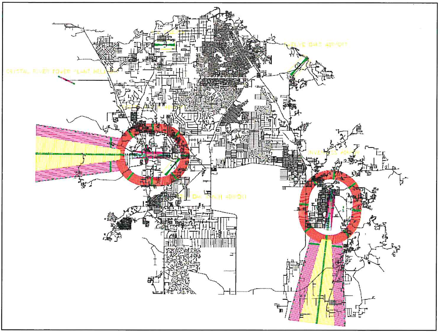
Airspace Height Limitation Zones
(Note - This figure is a representation of a three-dimensional figure that is on file with the Citrus County Surveyor's Office in the Department of Public Works).
a.
Primary Surface: A surface longitudinally centered on a runway. When the runway has a specially prepared hard surface, the primary surface extends two hundred (200) feet beyond each end of that runway. When the runway has no specially prepared hard surfaces (turf) the primary surface for such runways ends at each end of that runway. The elevation of any point on the primary surface is the same as the elevation of the nearest point on the runway centerline critical for aircraft to navigate the airfield. The width of the primary surface shall be as follows:
1.
Inverness Airport - Runway 01 and 09: Five hundred (500) feet.
b.
Transitional Surface: These surfaces extend outward and upward at right angles to the runway centerline and the runway centerline extended at a slope of 7:1 from the sides of the primary surface and approach surfaces. Transitional surfaces for those portions of the precision instrument approach surface that project through and beyond the limits of the conical surface extend a distance of five thousand (5,000) feet horizontally from the edge of the approach surface and at right angles to the runway centerline. No structure will be permitted if determined to be a hazard by the Aeronautical Study. Should the study determine the structure is an obstruction but is not a hazard, the owner shall provide the required lighting and marking as specified in the study determination letter.
c.
Horizontal Surface: A horizontal plan one hundred fifty (150) feet above the established airport elevation, the perimeter of which is constructed by swinging arcs of specified radii from the center of each end of the primary surface of each runway of each airport and connecting adjacent arcs by lines tangent to those arcs. The radius of each arc is:
1.
Inverness Airport Runway 01 and 09: Ten thousand (10,000) feet.
The radius of the arch specified for each end of a runway shall have the same arithmetical value. That value will be the highest determined for either end of the runway. When a five thousand-foot arc is encompassed by tangents connecting two (2) adjacent ten thousand-foot arcs, the five thousand-foot arc shall be disregarded. No structure will be permitted if determined by the Aeronautical Study to be an obstruction and a hazard to air navigation. Should the study determine the structure is an obstruction but is not a hazard to air navigation, the owner shall provide the required lighting and marking as specified in the study determination letter. The City reserves the right to deny any obstruction within the horizontal surface and/or require additional lighting beyond the FAA requirements where applicable.
d.
Conical Surface: A surface extending outward and upward from the periphery of the horizontal surface at a slope of 20:1 for a horizontal distance of four thousand (4,000) feet. The surface is one hundred fifty (150) feet above the established airport elevation at the inner boundary height increasing one (1) foot vertically for every twenty (20) feet of horizontal distance outward from the inner boundary of the zone to a height of two hundred fifty (250) feet above the established airport elevation at the outer boundary of the zone.
e.
Approach Surface: A surface longitudinally centered on the extended runway centerline and proceeding outward and upward from each end of the primary surface. The approach surface is applied to each runway end of each runway based upon the type of approach available or planned for the runway in the future.
1.
The inner edge of the approach surface is the same width as the primary surface, and it extends uniformly to the width:
2.
Inverness Airport Runway 01 and 09: Three thousand five hundred (3,500) feet.
3.
The approach surface extends for a horizontal distance of:
a.
Inverness Airport Runway 01 and 09: Ten thousand (10,000) feet at a 34:1 slope.
Height limitations within the approach surface are the same as the height of the runway end at the inner boundary and increase at the rates shown above and will control all future construction or natural growth.
Height limitations within the approach surface are the same as the height of the runway end at the inner boundary and increase at the rates shown above and will control all future construction or natural growth. On existing runways where thresholds have been displaced and threshold lights have been moved along the runway end; if any of the area between the threshold lights and red end lights is being used for either landing or takeoff of aircraft, then the approach surface would start at the end of the runway for control of future obstructions.
f.
Primary Surface: The surface area longitudinally centered on each runway, extending to the end of that runway. The elevation of any point on the primary surface is the same as the elevation of the nearest point on the runway centerline. At those airports have defined runways with specially prepared hard surfaces, the primary surface for each runway extends two hundred (200) feet beyond each end of the runway hard surface and the approach surface begins at that point. Within the primary surface, no structures will be permitted that are not critical for aircraft to navigate the airfield.
g.
Visual Approach Surface: A surface longitudinally centered on the extended runway centerline and proceeding outward and upward from each end of the primary surface. The width and height of the approach surface is the same at the inner boundary as the primary surface it adjoins to and expands uniformly to a width of one thousand two hundred fifty (1,250) feet for that end of a utility runway with only visual approaches. No structure shall penetrate the approach surface. The City shall utilize a specialized software owned and provided by the County to evaluate the height of a proposed structure to determine if the visual approach surface is penetrated.
h.
Transitional Surface: These surfaces extend outward and upward at right angles to the runway centerline and the runway centerline extended at a slope of 7 to 1 from the sides of the primary surface and from the sides of the approach surfaces. No structures should penetrate the transitional surface. The City shall utilize a specialized software owned and provided by the County to evaluate the height of proposed structure to determine if the transitional approach surface is penetrated.
2.
Other Areas. In addition to height limitations imposed in this section, no structure will be permitted in the City that exceeds five thousand (500) feet above the established Inverness Airport elevation and within three (3) nautical miles of the established reference point of the Inverness Airport covered by this section, without an Aeronautical Study determination of no hazard to airspace.
D.
Inverness Airport Land Use Restrictions.
1.
Notwithstanding any other provisions of this section, no use may be made of land or water within the City in such a manner as to create an Inverness Airport hazard or compromise the health, safety, and welfare of any person on the ground. The following special requirements shall apply to each permitted use:
a.
No lights or illuminations used in conjunction with streets, parking, signs, or use of land and structures shall be arranged or operated in such a manner that exceeds the Airspace Height Limitations of this section, or otherwise resembles Inverness Airport approach light that could be misleading or dangerous to aircraft operating from the Inverness Airport or in the vicinity thereof.
b.
No operations from any use shall produce smoke, glare, or visual hazards within three (3) statute miles of any usable runway of the Inverness Airport.
c.
No use shall be permitted in the City which is determined by the Aeronautical Study to produce electronic interference with navigation signals or radio communications between the Inverness Airport and an aircraft, in accordance with 14 CFR Part 77, Subpart B.
d.
No landfills, as defined in Florida Statutes 403.703, shall be permitted to be located as follows within the following areas:
1.
Within ten thousand (10,000) feet from the nearest point of any runway of the Inverness Airport used or planned to be used by turbine aircraft; or
2.
Within five thousand (5,000) feet from the nearest point of any runway of the Inverness Airport used by only non-turbine aircraft; or
3.
Outside the perimeters defined in subparagraphs 1. and 2., but still within the lateral limits of the Inverness Airport imaginary surfaces defined in 14 CFR s 77.19.
4.
Where any landfill is located and constructed in a manner so that it attracts or sustains hazardous bird movements from feeding, water or roosting areas into, or across, the runways or approach and departure patterns of aircraft. The operator of such a landfill must incorporate, at the owner's expense, bird management techniques or other practices to minimize bird hazards to airborne aircraft.
2.
For any structure determined by the FAA to be an obstruction, lighting and marking shall comply with the requirements determined through the Aeronautical Study and specifically outlined in the FAA Determination Letter. Lighting and marking shall conform with FAA Advisory Circular 70/FAA 7460-1 form, Obstruction marking and Lighting. All required lighting and marking shall be installed, maintained, and operated at the expense of the structure's owner.
E.
Nonconforming Uses.
1.
The regulations and restrictions prescribed in this section shall not be construed to require removal, lowering, or other change or alteration of any existing structure or natural growth legally permitted on the effective date hereof, or otherwise interfere with continuance of such nonconforming uses, except as provided in this section. However, no preexisting nonconforming structure, natural vegetation, or use shall be replaced, rebuilt, altered, enlarged, extended, or allowed to grow higher, or to be replanted, to constitute an increase in the degree of nonconformity with the regulations of this LDC.
2.
As outlined in Florida Statutes 333.07, if a nonconforming use or obstruction has been abandoned or is more than eighty (80) percent of the obstruction is torn down, destroyed, deteriorated, or decayed, a permit may not be granted if it would allow the obstruction to exceed the allowable height limit or otherwise deviate from the standards of this section. Regardless of whether an application is made, the owner of the nonconforming obstruction may be required, at his or her own expense, to lower, remove, reconstruct, alter, or equip such obstruction as necessary to conform to the current standards of this section. If the owner of the nonconforming obstruction fails or refuses to comply with such requirement for ten (10) days after notice, the City may proceed to have the obstruction so lowered, removed, reconstructed, altered, or equipped and assess the cost and expense thereof upon the owner of the obstruction or the land whereon it is or was located.
F.
Administration.
1.
The City Manager or designee shall maintain a zoning type map showing the Airspace Height Limitation surfaces for the Inverness Airport covered by this section.
2.
If, in the opinion of the City Manager, or designee, there is a possibility that issuance of any Development Permit or Development Order, although appearing to comply with this section, might or could be a hazard, it shall be the responsibility of the City Manager or designee, to forward a copy of such request to the County.
G.
Appeals Procedures. The procedure for appeals is as outlined elsewhere in this Code.
H.
Enforcement and Remedies. The procedures for penalties, remedies and enforcement standards are outlined elsewhere in this Code and/or the City Code of Ordinances.
(Ord. No. 2020-751, § 1(Exh. A), 4-7-20)