
Jackson County Unincorporated
City Zoning Code
City Zoning Code
ARTICLE 10
- FLOOD DAMAGE PREVENTION
Sec. 1001. - Authority.
Article IX, section II of the Constitution of the State of Georgia and O.C.G.A § 36-1-20(a) have delegated the responsibility to local governmental units to adopt regulations designed to promote the public health, safety, and general welfare of its citizenry.
(Ord. No. 17-003, § 1, 10-2-2017)
Sec. 1002. - Findings.
(a)
The flood hazard areas of Jackson County, Georgia are subject to periodic inundation which results in loss of life and property, health and safety hazards, disruption of commerce and governmental services, extraordinary public expenditures for flood relief and protection, and impairment of the tax base, all of which adversely affect the public health, safety and general welfare.
(b)
These flood losses are caused by the occupancy in flood hazard areas of uses vulnerable to floods, which are inadequately elevated, flood-proofed, or otherwise unprotected from flood damages, and by the cumulative effect of obstructions in floodplains causing increases in flood heights and velocities.
(c)
The degree of flood protection required by this article is considered reasonable for regulatory purposes and is based on scientific and engineering considerations. Larger floods can and will occur; flood heights may be increased by man-made or natural causes. This article does not imply that land outside the areas of special flood hazard or uses permitted within such areas will be free from flooding or flood damages. This article shall not create liability on the part of Jackson County, or by any officer or employee thereof for any flood damages that result from reliance on this article or any administrative decision lawfully made hereunder.
(Ord. No. 17-003, § 1, 10-2-2017)
Sec. 1003. - Purposes.
It is the purpose of this article to promote the public health, safety and general welfare and to minimize public and private losses due to flood conditions in specific areas by provisions applicable in the unincorporated areas of Jackson County designed to:
(a)
Require that uses vulnerable to floods, including facilities, which serve such uses, be protected against flood damage at the time of initial construction;
(b)
Restrict or prohibit uses which are dangerous to health, safety and property due to water or erosion hazards, or which increase flood heights, velocities, or erosion;
(c)
Control filling, grading, dredging and other development which may increase flood damage or erosion;
(d)
Prevent or regulate the construction of flood barriers which will unnaturally divert flood waters or which may increase flood hazards to other lands; and
(e)
Control the alteration of natural floodplains, stream channels, and natural protective barriers, which are involved in the accommodation of floodwaters.
(Ord. No. 17-003, § 1, 10-2-2017)
Sec. 1004. - Objectives.
The objectives of this article are to:
(a)
Protect human life and health;
(b)
Minimize damage to public facilities and utilities such as water and gas mains, electric, telephone and sewer lines, streets and bridges located in floodplains;
(c)
Help maintain a stable tax base by providing for the sound use and development of flood prone areas in such a manner as to minimize flood blight areas;
(d)
Minimize expenditure of public money for costly flood control projects;
(e)
Minimize the need for rescue and relief efforts associated with flooding and generally undertaken at the expense of the general public;
(f)
Minimize prolonged business interruptions; and
(g)
Insure that potential homebuyers are notified that property is in a flood area.
(Ord. No. 17-003, § 1, 10-2-2017)
Sec. 1005. - Applicability.
This UDC shall apply to all areas of special flood hazard within unincorporated Jackson County, Georgia.
(Ord. No. 17-003, § 1, 10-2-2017)
Sec. 1006. - Definitions.
Unless specifically defined below, words or phrases used in this section shall be interpreted so as to give them the meaning they have in common usage and to give this section its most reasonable application.
Accessory structure: A structure having minimal value and used for parking, storage and other non-habitable uses, such as garages, carports, storage sheds, pole barns, hay sheds and the like.
Addition (to an existing building): Any walled and roofed expansion to the perimeter of a building in which the addition is connected by a common load-bearing wall other than a firewall. Any walled and roofed addition, which is connected by a firewall or is separated by an independent perimeter load-bearing wall, shall be considered "new construction."
Administrator: The director of Public Development for Jackson County, Georgia.
Appeal: A request for a review of the public development director's interpretation of any provision of this article.
Area of shallow flooding: A designated AO or AH zone on a community's flood insurance rate map (FIRM) with base flood depths from one to three feet, and/or where a clearly defined channel does not exist, where the path of flooding is unpredictable and indeterminate, and where velocity flow may be evident.
Area of special flood hazard: The land in the floodplain within a community subject to a one percent or greater chance of flooding in any given year. In the absence of official designation by the Federal Emergency Management Agency, areas of special flood hazard shall be those designated by the local community and referenced in this article.
Base flood: The flood having a one percent chance of being equaled or exceeded in any given year.
Base flood elevation (BFE): The elevation shown on the flood insurance rate map for zones AE, AH, A1-A30, AR, AR/A, AR/AE, AR/A1-A30, AR/AH, AR/AO, V1-V30, and VE that indicates the water surface elevation resulting from a flood that has a one percent chance of equaling or exceeding that level in any given year.
Basement: That portion of a building having its floor sub grade (below ground level) on all sides.
Building: Any structure built for support, shelter, or enclosure for any occupancy or storage.
Critical facility: Any public or private facility, which, if flooded, would create an added dimension to the disaster or would increase the hazard to life and health. Critical facilities include: structures or facilities that produce, use, or store highly volatile, flammable, explosive, toxic, or water-reactive materials; hospitals and nursing homes, and housing for the elderly, which are likely to contain occupants who may not be sufficiently mobile to avoid the loss of life or injury during flood and storm events; emergency operation centers or data storage centers which contain records or services that may become lost or inoperative during flood and storm events; and generating plants, and other principal points of utility lines.
Development: Any man-made change to improved or unimproved real estate, including, but not limited to, buildings or other structures, mining, dredging, filling, grading, paving, excavating, drilling operations, and storage of materials or equipment.
Elevated building: A non-basement building built to have the lowest floor of the lowest enclosed area elevated above the ground level by means of fill, solid foundation perimeter walls, pilings, columns, piers, or shear walls adequately anchored so as not to impair the structural integrity of the building during a base flood event.
Existing construction: For the purposes of determining rates, structures for which the "start of construction" commenced before the effective date of the initial flood insurance rate maps for that community.
Existing manufactured home park or subdivision: A manufactured home park or subdivision for which the construction of facilities for servicing the lots on which the manufactured homes are to be affixed (including at a minimum the installation of utilities, the construction of streets, and final site grading or the pouring of concrete pads) is completed before June 19, 1986 (i.e., the effective date of the first floodplain management regulations adopted by Jackson County).
Expansion to an existing manufactured home park or subdivision: The preparation of additional sites by the construction of facilities for servicing the lots on which the manufactured homes are to be affixed, including the installation of utilities, the construction of streets, and either final site grading or the pouring of concrete pads.
Flood or flooding: A general and temporary condition of partial or complete inundation of normally dry land areas from: the overflow of inland or tidal waters; or the unusual and rapid accumulation or runoff of surface waters from any source.
Flood hazard boundary map (FHBM): An official map of a community, issued by the Federal Insurance Administration, where the boundaries of areas of special flood hazard have been defined as zone A.
Flood insurance rate map (FIRM): An official map of a community, issued by the Federal Insurance Administration, delineating the areas of special flood hazard and/or risk premium zones applicable to the community.
Flood insurance study: The official report by the Federal Insurance Administration evaluating flood hazards and containing flood profiles and water surface elevations of the base flood.
Floodplain: Any land area susceptible to flooding.
Flood proofing: Any combination of structural and non-structural additions, changes, or adjustments to structures, which reduce or eliminate flood damage to real estate or improved real property, water and sanitary facilities, structures and their contents.
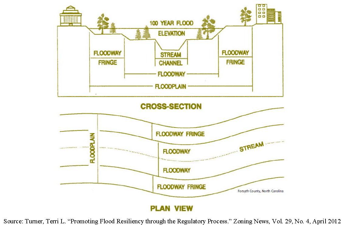
Floodway: The channel of a river or other watercourse and the adjacent land areas that must be reserved in order to discharge the base flood without cumulatively increasing the water surface elevation more than a designated height.
Freeboard: A factor of safety usually expressed in feet above a flood level for purposes of floodplain management. "Freeboard" tends to compensate for the many unknown factors that could contribute to flood heights greater than the height calculated for a selected size flood and floodway conditions, such as wave action, bridge openings, and the hydrological effect of urbanization of the watershed.
Highest adjacent grade: The highest natural elevation of the ground surface, prior to construction, adjacent to the proposed foundation of a building.
Historic structure: Any structure that is: listed individually in the National Register of Historic Places (a listing maintained by the U.S. Department of Interior) or preliminarily determined by the Secretary of the Interior as meeting the requirements for individual listing on the National Register; certified or preliminarily determined by the Secretary of the Interior as contributing to the historical significance of a registered historic district or a district preliminarily determined by the Secretary to qualify as a registered historic district; individually listed on a state inventory of historic places and determined as eligible by states with historic preservation programs which have been approved by the Secretary of the Interior; or individually listed on a local inventory of historic places and determined as eligible by communities with historic preservation programs that have been certified either:
(1)
By an approved state program as determined by the Secretary of the Interior; or
(2)
Directly by the Secretary of the Interior in states without approved programs.
Lowest floor: The lowest floor of the lowest enclosed area, including basement. An unfinished or flood resistant enclosure, used solely for parking of vehicles, building access, or storage, in an area other than a basement, is not considered a building's lowest floor, provided that such enclosure is not built so as to render the structure in violation of other provisions of this section.
Manufactured home: A building, transportable in one or more sections, built on a permanent chassis and designed to be used with or without a permanent foundation when connected to the required utilities. The term also includes park trailers, travel trailers, and similar transportable structures placed on a site for 180 consecutive days or longer and intended to be improved property.
Manufactured home park or subdivision: A parcel (or contiguous parcels) of land divided into two or more manufactured home lots for rent or sale.
Mean sea level: The average height of the sea for all stages of the tide. It is used as a reference for establishing various elevations within the floodplain. For purposes of the National Flood Insurance Program, the National Geodetic Vertical Datum (NGVD) of 1929 or other datum, to which base flood elevations shown on a community's flood insurance rate map are referenced.
National Geodetic Vertical Datum (NGVD): As corrected in 1929 is a vertical control used as a reference for establishing varying elevations within the floodplain.
New construction: For the purposes of determining insurance rates, structures for which the "start of construction" commenced after the effective date of the initial flood insurance rate map and includes any subsequent improvements to such structures. For floodplain management purposes, "new construction" means structures for which the "start of construction" commenced after June 19, 1986 (i.e., the effective date of the first floodplain management ordinance adopted by Jackson County) and includes any subsequent improvements to such structures.
New manufactured home park or subdivision: A manufactured home park or subdivision for which the construction of facilities for servicing the lots on which the manufactured homes are to be affixed (including at a minimum, the installation of utilities, the construction of streets, and either final site grading or the pouring of concrete pads) is completed after June 19, 1986 (i.e., the effective date of the first floodplain management ordinance adopted by Jackson County).
North American Vertical Datum (NAVD): Has replaced the National Geodetic Vertical Datum of 1929 in existing and future FEMA flood modernization maps.
Recreational vehicle: A vehicle, which is built on a single chassis; 400 square feet or less when measured at the largest horizontal projection; designed to be self-propelled or permanently towable by a light duty truck; and designed primarily not for use as a permanent dwelling but as temporary living quarters for recreational, camping, travel, or seasonal use.
Start of construction: The date the development permit was issued, provided the actual start of construction, repair, reconstruction, or improvement was within 180 days of the permit date. The actual start means the first placement of permanent construction of the structure such as the pouring of slabs or footings, installation of piles, construction of columns, or any work beyond the stage of excavation, and includes the placement of a manufactured home on a foundation. (Permanent construction does not include initial land preparation, such as clearing, grading and filling; nor does it include the installation of streets and/or walkways; nor does it include excavation for a basement, footings, piers or foundations or the erection of temporary forms; nor does it include the installation on the property of buildings appurtenant to the permitted structure, such as garages or sheds not occupied as dwelling units or part of the main structure. (NOTE: accessory structures are NOT exempt from any ordinance requirements). For a substantial improvement, the actual start of construction means the first alteration of any wall, ceiling, floor, or other structural part of a building, whether or not that alteration affects the external dimensions of the building.
Structure: A walled and roofed building that is principally above ground, a manufactured home, a gas or liquid storage tank.
Subdivision: The division of a single lot into two or more lots for the purpose of sale or development.
Substantial damage: Damage of any origin sustained by a structure whereby the cost of restoring the structure to its before damaged condition would equal or exceed 50 percent of the market value of the structure before the damage occurred.
Substantial improvement: Any reconstruction, rehabilitation, addition, or other improvement of a structure, taking place during a five-year period, in which the cumulative cost equals or exceeds 50 percent of the market value of the structure prior to the "start of construction" of the improvement. Note: The market value of the structure should be:
(1)
The appraised value of the structure prior to the start of the initial repair or improvement; or
(2)
In the case of damage, the value of the structure prior to the damage occurring. This term includes structures, which have incurred "substantial damage," regardless of the actual amount of repair work performed.
For the purposes of this definition, "substantial improvement" is considered to occur when the first alteration of any wall, ceiling, floor, or other structural part of the building commences, whether or not that alteration affects the external dimensions of the building. The term does not, however, include:
(1)
Those improvements of a structure required to comply with existing violations of state or local health, sanitary, or safety code specifications which are solely necessary to assure safe living conditions and which have been identified by the administrator or his or her designee, and not solely triggered by an improvement or repair project; or
(2)
Any alteration of a "historic structure" provided that the alteration will not preclude the structure's continued designation as a "historic structure."
Substantially improved existing manufactured home parks or subdivisions: Where the repair, reconstruction, rehabilitation or improvement of the streets, utilities and pads equals or exceeds 50 percent of the value of the streets, utilities and pads before the repair, reconstruction or improvement commenced.
Variance: A grant of relief from the requirements of this article, which permits construction in a manner otherwise prohibited by this section.
Violation: The failure of a structure or other development to be fully compliant with the community's floodplain management regulations. A structure or other development without the elevation certificate, or other certifications, or other evidence of compliance required by this UDC is presumed to be in violation until such time as that documentation is provided.
(Ord. No. 17-003, § 1, 10-2-2017)
Sec. 1007. - Basis for area of special flood hazard.
(a)
Flood insurance study. The areas of special flood hazard identified by the Federal Emergency Management Agency in its Flood Insurance Study (FIS), for Jackson County, Georgia and incorporated areas effective December 17, 2010, with accompanying maps and other supporting data and any revision thereto, are adopted by reference and declared a part of this article.
(b)
Flood insurance rate maps. The flood insurance rate maps for Jackson County, Georgia and incorporated areas effective December 17, 2010, are adopted as if fully contained within this article and shall be the basis for determining areas of special flood hazard.
(c)
Additional areas of special flood hazard. Areas of special flood hazard may also include those areas known to have flooded historically or defined through standard engineering analysis by governmental agencies or private parties but not yet incorporated in a flood insurance study.
(d)
Repository. The repository for public inspection of the flood insurance study (FIS), accompanying maps and other supporting data and the flood insurance rate maps is the Jackson County Department of Public Development, 67 Athens Street, Jefferson, Georgia, 30549.
(Ord. No. 17-003, § 1, 10-2-2017)
Sec. 1011. - Permit required.
No development activity shall commence within an area regulated by this article until and unless a flood area permit shall have been approved by the public development director. No development activity shall be approved unless it conforms with the provisions of this article prior to the commencement of any development activities. No building or structure shall be constructed within an area regulated by this article until and unless a flood area permit or building permit, or both if required shall have been approved by the public development director. No building or structure shall be approved unless it conforms with the provisions of this article prior to the construction of said building or structure.
(Ord. No. 17-003, § 1, 10-2-2017)
Sec. 1012. - Permit procedures.
Application for a flood area permit shall be made to the public development department on forms furnished by the department prior to any development activities, and may include, but not be limited to the following: plans in sufficient number as specified by the department, drawn to scale showing the elevations of the area in question and the nature, location, dimensions, of existing or proposed structures, earthen fill placement, storage of materials or equipment, and drainage facilities.
(Ord. No. 17-003, § 1, 10-2-2017)
Sec. 1013. - Specific information required—Application stage.
The following information is required at the application stage:
(a)
Elevation in relation to mean sea level (or highest adjacent grade) of the lowest floor, including basement, of all proposed structures;
(b)
Elevation in relation to mean sea level to which any non-residential structure will be flood-proofed;
(c)
Design certification from a registered professional engineer or architect that any proposed non-residential flood-proofed structure will meet the flood-proofing criteria of this article; and
(d)
Description of the extent to which any watercourse will be altered or relocated as a result of a proposed development.
(Ord. No. 17-003, § 1, 10-2-2017)
Sec. 1014. - Specific information required—Construction stage.
The following information is required at the construction stage:
(a)
For all new construction and substantial improvements, the permit holder shall provide to the public development department an as-built certification of the regulatory floor elevation or flood-proofing level immediately after the lowest floor or flood proofing is completed. Any lowest floor certification made relative to mean sea level shall be prepared by or under the direct supervision of a registered land surveyor or professional engineer and certified by same. When flood proofing is utilized for non-residential structures, said certification shall be prepared by or under the direct supervision of a professional engineer or architect and certified by same.
(b)
Any work undertaken prior to submission of these certifications shall be at the permit holder's risk. The director of public development shall review the above referenced certification data submitted. Deficiencies detected by such review shall be corrected by the permit holder immediately and prior to further progressive work being allowed to proceed. Failure to submit certification or failure to make said corrections required hereby, shall be cause to issue a stop-work order for the project.
(Ord. No. 17-003, § 1, 10-2-2017)
Sec. 1021. - General standards.
In all areas of special flood hazard the following provisions are required:
(a)
Anchoring. New construction and substantial improvements of existing structures shall be anchored to prevent flotation, collapse or lateral movement of the structure.
(b)
Flood-resistant materials. New construction and substantial improvements of existing structures shall be constructed with materials and utility equipment resistant to flood damage.
(c)
Construction methods and practices. New construction or substantial improvements of existing structures shall be constructed by methods and practices that minimize flood damage.
(d)
Heating and air conditioning. All heating and air conditioning equipment and components (including ductwork), all electrical, ventilation, plumbing, and other service facilities shall be designed and/or located so as to prevent water from entering or accumulating within the components during conditions of flooding.
(e)
Manufactured homes. Manufactured homes shall be anchored to prevent flotation, collapse, or lateral movement. Methods of anchoring may include, but are not limited to, use of over-the-top or frame ties to ground anchors. This standard shall be in addition to and consistent with applicable state requirements for resisting wind forces.
(f)
Water supply. New and replacement water supply systems shall be designed to minimize or eliminate infiltration of flood waters into the system.
(g)
Sewage systems. New and replacement sanitary sewage systems shall be designed to minimize or eliminate infiltration of flood waters into the systems and discharges from the systems into flood waters.
(h)
On-site sewage disposal systems. On-site waste disposal systems shall be located and constructed to avoid impairment to them or contamination from them during flooding.
(i)
Nonconformities. Any alteration, repair, reconstruction or improvement to a structure, which is not compliant with the provisions of this UDC, shall be undertaken only if the non-conformity is not furthered, extended or replaced.
(Ord. No. 17-003, § 1, 10-2-2017)
Sec. 1022. - Elevated buildings.
(a)
In all areas of special flood hazard, all new construction or substantial improvements of existing structures that include any fully enclosed area located below the lowest floor formed by foundation and other exterior walls shall be designed so as to be an unfinished or flood resistant enclosure. The enclosure shall be designed to equalize hydrostatic flood forces on exterior walls by allowing for the automatic entry and exit of floodwater.
(b)
Designs for complying with this requirement must either be certified by a professional engineer or architect or meet the following minimum criteria:
1.
Provide a minimum of two openings having a total net area of not less than one square inch for every square foot of enclosed area subject to flooding;
2.
The bottom of all openings shall be no higher than one foot above grade; and,
3.
Openings may be equipped with screens, louvers, valves or other coverings or devices provided they permit the automatic flow of floodwater in both direction.
(c)
So as not to violate the "lowest floor" criteria of this UDC, the unfinished or flood resistant enclosure shall only be used for parking of vehicles, limited storage of maintenance equipment used in connection with the premises, or entry to the elevated area, and
(d)
The interior portion of such enclosed area shall not be partitioned or finished into separate rooms.
(Ord. No. 17-003, § 1, 10-2-2017)
Sec. 1023. - New construction and/or substantial improvements.
In all areas of special flood hazard the following provisions are required for new construction and/or substantial improvements:
(a)
Where base flood elevation data are available, new construction and/or substantial improvement of any structure or manufactured home shall have the lowest floor, including basement, elevated no lower than two feet above the base flood elevation. Should solid foundation perimeter walls be used to elevate a structure, openings sufficient to facilitate equalization of flood hydrostatic forces on both sides of exterior walls shall be provided in accordance with standards of this article for "elevated buildings."
(b)
All heating and air conditioning equipment and components (including ductwork), all electrical, ventilation, plumbing, and other service facilities shall be elevated at or above two feet above the base flood elevation.
(Ord. No. 17-003, § 1, 10-2-2017)
Sec. 1024. - Non-residential construction.
(a)
New construction and/or the substantial improvement of any structure located in A1-30, AE, or AH zones, may be flood-proofed in lieu of elevation. The structure, together with attendant utility and sanitary facilities, must be designed to be water tight to two feet above the base flood elevation, with walls substantially impermeable to the passage of water, and structural components having the capability of resisting hydrostatic and hydrodynamic loads and the effect of buoyancy.
(b)
A registered professional engineer or architect shall certify that the design and methods of construction are in accordance with accepted standards of practice for meeting the provisions above, and shall provide such certification to the public development director as set forth in this article.
(Ord. No. 17-003, § 1, 10-2-2017)
Sec. 1025. - Manufactured homes.
Where base flood elevation data are available:
(a)
All manufactured homes placed and/or substantially improved on:
(1)
Individual lots or parcels;
(2)
In new and/or substantially improved manufactured home parks or subdivisions;
(3)
In expansions to existing manufactured home parks or subdivisions; or
(4)
On a site in an existing manufactured home park or subdivision where a manufactured home has incurred "substantial damage" as the result of a flood, must have the lowest floor including basement, elevated no lower than two feet above the base flood elevation.
(b)
Manufactured homes placed and/or substantially improved in an existing manufactured home park or subdivision may be elevated so that either: the lowest floor of the manufactured home is elevated no lower than two feet above the level of the base flood elevation; or the manufactured home chassis is elevated and supported by reinforced piers (or other foundation elements of at least an equivalent strength) of no less than 36 inches in height above grade.
(c)
All manufactured homes must be securely anchored to an adequately anchored foundation system to resist flotation, collapse and lateral movement.
(Ord. No. 17-003, § 1, 10-2-2017)
Sec. 1026. - Recreational vehicles.
All recreational vehicles placed on sites must either:
(a)
Be on the site for fewer than 180 consecutive days;
(b)
Be fully licensed and ready for highway use, (a recreational vehicle is ready for highway use if it is licensed, on its wheels or jacking system, attached to the site only by quick disconnect type utilities and security devices, and has no permanently attached structures or additions); or
(c)
The recreational vehicle must meet all the requirements for "new construction," including the anchoring and elevation requirements of this article.
(Ord. No. 17-003, § 1, 10-2-2017)
Sec. 1027. - Floodway.
Located within areas of special flood hazard established in this article are areas designated as floodway. A floodway may be an extremely hazardous area due to velocity floodwaters, debris or erosion potential. In addition, the area must remain free of encroachment in order to allow for the discharge of the base flood without increased flood heights. Therefore, the following provisions shall apply:
(a)
Encroachments are prohibited, including earthen fill, new construction, substantial improvements or other development within the regulatory floodway. Development may be permitted however, provided it is demonstrated through hydrologic and hydraulic analyses performed in accordance with standard engineering practice that the encroachment shall not result in any increase in flood levels or floodway widths during a base flood discharge. A registered professional engineer must provide supporting technical data and certification thereof.
(b)
Only if the provisions of this section are satisfied, then any new construction or substantial improvement shall comply with all other applicable flood hazard reduction provisions of this article.
(Ord. No. 17-003, § 1, 10-2-2017)
Sec. 1028. - Building standards for streams without established base flood elevations and/or floodway (A-zones).
Located within the areas of special flood hazard established in this article, are streams for which no base flood data have been provided (A-zones), or where base flood data have been provided but a floodway has not been delineated. When base flood elevation data or floodway data have not been provided in accordance with this section, then the administrator shall obtain, review, and reasonably utilize any scientific or historic base flood elevation and floodway data available from a federal, state, or other source, in order to administer the provisions of this article. Only if data are not available from these sources, then the following provisions apply:
(a)
No encroachments, including structures or fill material, shall be located within an area equal to the width of the stream or 20 feet, whichever is greater, measured from the top of the stream bank, unless certification by a registered professional engineer is provided demonstrating that such encroachment shall not result in more than a one foot increase in flood levels during the occurrence of the base flood discharge.
(b)
In special flood hazard areas without base flood elevation data, new construction and substantial improvements of existing structures shall have the lowest floor of the lowest enclosed area (including basement) elevated no less than three feet above the highest adjacent grade at the building site. (NOTE: Require the lowest floor to be elevated one foot above the estimated base flood elevation in A-zone areas where a limited detail study has been completed). Openings sufficient to facilitate the unimpeded movements of floodwaters shall be provided in accordance with standards of this section for "elevated buildings."
(c)
All heating and air conditioning equipment and components (including ductwork), all electrical, ventilation, plumbing, and other service facilities shall be elevated no less than three feet above the highest adjacent grade at the building site.
(d)
The administrator shall certify the lowest floor elevation level and the record shall become a permanent part of the permit file.
(Ord. No. 17-003, § 1, 10-2-2017)
Sec. 1029. - Standards for areas of special flood hazard (zones AE) with established base flood elevations without designated floodways.
Located within the areas of special flood hazard established in this article, where streams with base flood elevations are provided but no floodways have been designated (zones AE), the following provisions apply:
(a)
No encroachments, including fill material, new structures or substantial improvements shall be located within areas of special flood hazard, unless certification by a registered professional engineer is provided demonstrating that the cumulative effect of the proposed development, when combined with all other existing and anticipated development, will not increase the water surface elevation of the base flood more than one foot at any point within the community. The engineering certification should be supported by technical data that conforms to standard hydraulic engineering principles.
(b)
New construction or substantial improvements of buildings shall be elevated or flood-proofed to elevations established in accordance with this article.
(Ord. No. 17-003, § 1, 10-2-2017)
Sec. 1030. - Standards for areas of shallow flooding (AO zones).
Areas of special flood hazard established in this section may include designated "AO" shallow flooding areas. These areas have base flood depths of one to three feet above ground, with no clearly defined channel. The following provisions apply:
(a)
All new construction and substantial improvements of residential and non-residential structures shall have the lowest floor, including basement, elevated to the flood depth number specified on the flood insurance rate map (FIRM), above the highest adjacent grade. If no flood depth number is specified, the lowest floor, including basement, shall be elevated at least three feet above the highest adjacent grade. Openings sufficient to facilitate the unimpeded movements of flood waters shall be provided in accordance with standards of this article for "elevated buildings." The administrator shall certify the lowest floor elevation level and the record shall become a permanent part of the permit file.
(b)
New construction or the substantial improvement of a non-residential structure may be flood-proofed in lieu of elevation. The structure, together with attendant utility and sanitary facilities, must be designed to be water tight to the specified FIRM flood level plus two feet, above highest adjacent grade, with walls substantially impermeable to the passage of water, and structural components having the capability of resisting hydrostatic and hydrodynamic loads and the effect of buoyancy. A registered professional engineer or architect shall certify that the design and methods of construction are in accordance with accepted standards of practice for meeting the provisions above, and shall provide such certification to the official as set forth in this paragraph and as required in this article.
(c)
Drainage paths shall be provided to guide floodwater around and away from any proposed structure.
(Ord. No. 17-003, § 1, 10-2-2017)
Sec. 1031. - Subdivisions.
(a)
All subdivision and/or development proposals shall be consistent with the need to minimize flood damage.
(b)
All subdivision and/or development proposals shall have public utilities and facilities such as sewer, gas, electrical and water systems located and constructed to minimize flood damage.
(c)
All subdivision and/or development proposals shall have adequate drainage provided to reduce exposure to flood hazards.
(d)
For subdivisions and/or developments greater than 50 lots or five acres, whichever is less, base flood elevation data shall be provided for subdivision and all other proposed development, including manufactured home parks and subdivisions. Any changes or revisions to the flood data adopted herein and shown on the FIRM shall be submitted to FEMA for review as a conditional letter of map revision (CLOMR) or conditional letter of map amendment (CLOMA), whichever is applicable. Upon completion of the project, the developer is responsible for submitting the "as-built" data to FEMA in order to obtain the final LOMR.
(Ord. No. 17-003, § 1, 10-2-2017)
Sec. 1032. - Critical facilities.
Critical facilities shall not be located in the 100-year floodplain or the 500-year floodplain. All ingress and egress from any critical facility must be protected to the 500-year flood elevation.
(Ord. No. 17-003, § 1, 10-2-2017)
Sec. 1041. - Variance procedures.
(a)
The board of adjustment shall hear and decide requests for appeals or variance from the requirements of this article. Procedures for consideration of variances to the requirements of this article shall be the same as provided in article 14 of this UDC for variances.
(b)
The board of adjustment shall hear and decide appeals when it is alleged an error in any requirement, decision, or determination is made by the public development director, in the enforcement or administration of this article. Procedures for consideration of appeals shall be the same as provided in article 14 of this UDC for appeals.
(c)
Any person aggrieved by the decision of the board of adjustment may appeal such decision to the Superior Court of Jackson County, as provided in O.C.G.A. § 5-4-1.
(Ord. No. 17-003, § 1, 10-2-2017)
Sec. 1042. - Criteria and conditions for variances.
The provisions of this article are minimum standards for flood loss reduction; therefore, any deviation from the standards must be weighed carefully. In reviewing requests for variances, the board of adjustment shall consider all technical evaluations, relevant factors, and the following standards in addition to others in this UDC. A variance shall be issued only when consistent with the following criteria and conditions:
(a)
A finding of good and sufficient cause is made.
(b)
A determination is made that failure to grant the variance would result in exceptional hardship.
(c)
A determination is made that the granting of a variance will not result in increased flood heights, additional threats to public safety, extraordinary public expense, create nuisance, cause fraud on or victimization of the public, or conflict with existing local laws or ordinances.
(d)
Variances shall not be issued within any designated floodway if any increase in flood levels during the base flood discharge would result.
(e)
Variances shall only be issued upon a determination that the variance is the minimum necessary, considering the flood hazard, to afford relief.
(f)
Variances may be issued for the repair or rehabilitation of historic structures upon a determination that the proposed repair or rehabilitation will not preclude the structure's continued designation as a historic structure and the variance is the minimum to preserve the historic character and design of the structure. In the instance of an historic structure, a determination that the variance is the minimum necessary so as not to destroy the historic character and design of the building.
(g)
Variances may be issued for development necessary for the conduct of a functionally dependent use, provided the criteria of this UDC are met, no reasonable alternative exists, and the development is protected by methods that minimize flood damage during the base flood and create no additional threats to public safety.
(Ord. No. 17-003, § 1, 10-2-2017)
Sec. 1043. - Conditional approval permitted.
Upon consideration of the factors listed above and the purposes of this UDC, the board of adjustment may attach such conditions to the granting of variances as it deems necessary to further the purposes of this article.
(Ord. No. 17-003, § 1, 10-2-2017)
Sec. 1044. - Actions following variance approval.
(a)
Any applicant to whom a variance is granted shall be given written notice specifying the difference between the base flood elevation and the elevation of the proposed lowest floor and stating that the cost of flood insurance will be commensurate with the increased risk to life and property resulting from the reduced lowest floor elevation.
(b)
The public development director shall maintain the records of all appeal actions and report any variances to the Federal Emergency Management Agency upon request.
(Ord. No. 17-003, § 1, 10-2-2017)
Sec. 1051. - Administration.
The public development director is hereby appointed to administer and implement the provisions of this article. Duties of the public development director shall include, but shall not be limited to the following:
(a)
Review proposed development to assure that the permit requirements of this article have been satisfied.
(b)
Review proposed development to assure that all necessary permits have been received from governmental agencies from which approval is required by Federal or State law, including section 404 of the Federal Water Pollution Control Act Amendments of 1972, 33 U.S.C. 1334. Require that copies of such permits be provided and maintained on file.
(c)
Review all permit applications to determine whether proposed building sites will be reasonably safe from flooding.
(d)
When base flood elevation data or floodway data have not been provided in accordance with this article, then the administrator shall obtain, review and reasonably utilize any base flood elevation and floodway data available from a federal, state or other sources in order to administer the provisions of this article.
(e)
Review and record the actual elevation in relation to mean sea level (or highest adjacent grade) of the lowest floor, including basement, of all new or substantially improved structures in accordance with this section.
(f)
Review and record the actual elevation, in relation to mean sea level to which any new or substantially improved structures have been flood-proofed, in accordance with this article.
(g)
When flood-proofing is utilized for a structure, the administrator shall obtain certification of design criteria from a registered professional engineer or architect in accordance with this article.
(h)
Make substantial damage determinations following a flood event or any other event that causes damage to structures in flood hazard areas.
(i)
Notify adjacent communities and the Georgia Department of Natural Resources prior to any alteration or relocation of a watercourse and submit evidence of such notification to the Federal Emergency Management Agency (FEMA).
(j)
For any altered or relocated watercourse, submit engineering data/analysis within six months to the FEMA to ensure accuracy of community flood maps through the letter of map revision process. Assure flood carrying capacity of any altered or relocated watercourse is maintained.
(k)
Make interpretations of this article. In the interpretation and application of this article all provisions shall be: considered as minimum requirements; liberally construed in favor of the county, and; deemed neither to limit nor repeal any other powers granted under state statutes. Where interpretation is needed as to the exact location of boundaries of the areas of special flood hazard (for example, where there appears to be a conflict between a mapped boundary and actual field conditions) the administrator shall make the necessary interpretation. Any person contesting the location of the boundary shall be given a reasonable opportunity to appeal the interpretation as provided in this article. In the interpretation and application of this UDC all provisions shall be:
(1)
Considered as minimum requirements;
(2)
Liberally construed in favor of the city; and
(3)
Deemed neither to limit nor repeal any other powers granted under state statutes.
(l)
All records pertaining to the provisions of this article shall be maintained in the office of the administrator and shall be open for public inspection.
(Ord. No. 17-003, § 1, 10-2-2017)
Sec. 1052. - Abrogation and greater restrictions.
This article is not intended to repeal, abrogate, or impair any existing ordinance, easements, covenants, or deed restrictions. However, where this article and another conflict or overlap, whichever imposes the more stringent restrictions shall prevail.
(Ord. No. 17-003, § 1, 10-2-2017)
Sec. 1053. - Warning and disclaimer of liability.
The degree of flood protection required by this article is considered reasonable for regulatory purposes and is based on scientific and engineering considerations. Larger floods can and will occur; flood heights may be increased by man-made or natural causes. This article does not imply that land outside the areas of special flood hazard or uses permitted within such areas will be free from flooding or flood damages. This article shall not create liability on the part of Jackson County, or by any officer or employee thereof for any flood damages that result from reliance on this article or any administrative decision lawfully made hereunder.
(Ord. No. 17-003, § 1, 10-2-2017)
Sec. 1054. - Penalties for violation.
Failure to comply with the provisions of this article or with any of its requirements, including conditions and safeguards established in connection with grants of variance shall constitute a violation. Any person who violates this UDC or fails to comply with any of its requirements shall be subject to the provisions of the Code of Jackson County. Nothing herein contained shall prevent Jackson County from taking such other lawful actions as is necessary to prevent or remedy any violation.
(Ord. No. 17-003, § 1, 10-2-2017)