
Jackson County Unincorporated
City Zoning Code
City Zoning Code
ARTICLE 5
- ENVIRONMENTAL OVERLAY DISTRICTS
Sec. 501. - Establishment.
There is hereby established the following environmental overlay districts in unincorporated Jackson County:
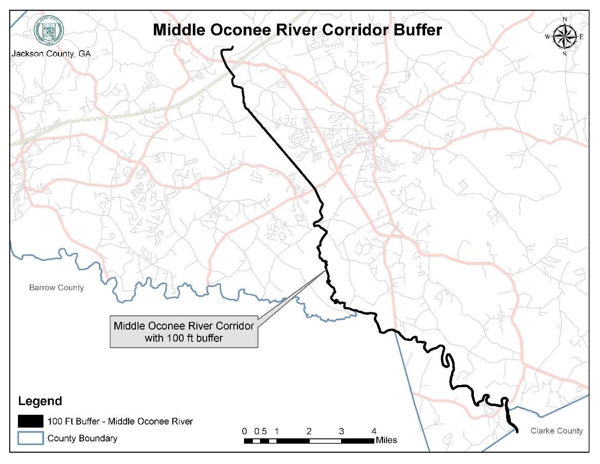
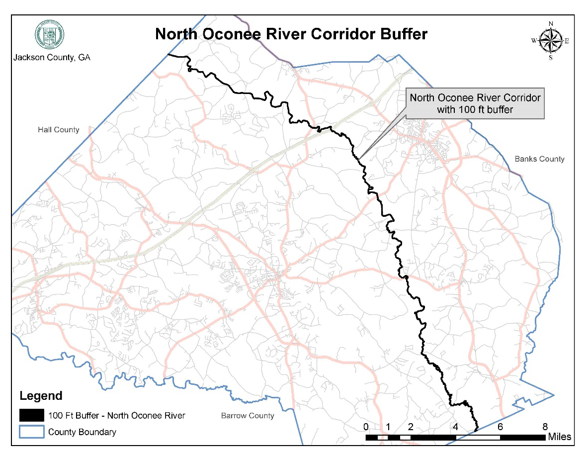
Middle Oconee River Corridor
North Oconee River Corridor
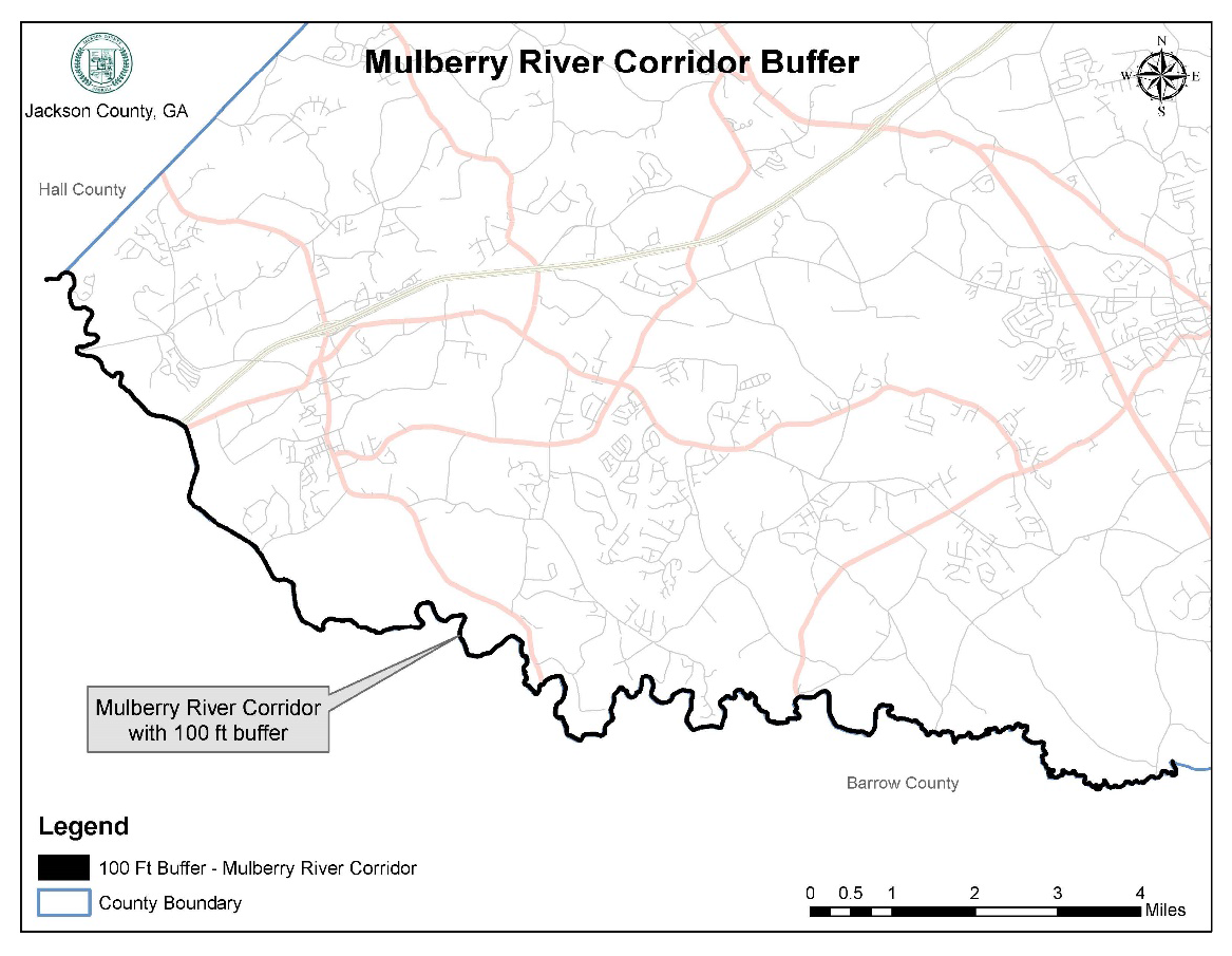
Mulberry River Corridor
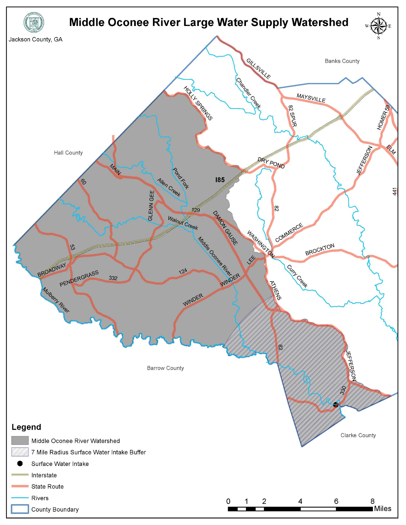
Middle Oconee River Large Water Supply Watershed
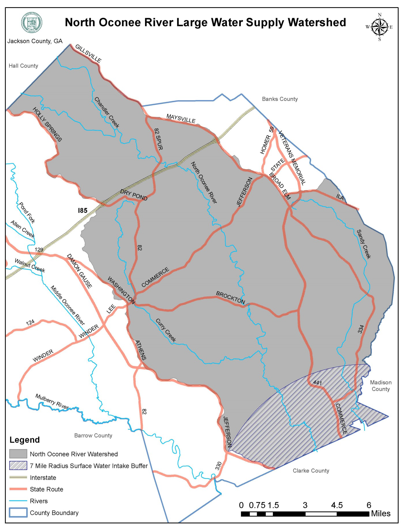
North Oconee River Large Water Supply Watershed
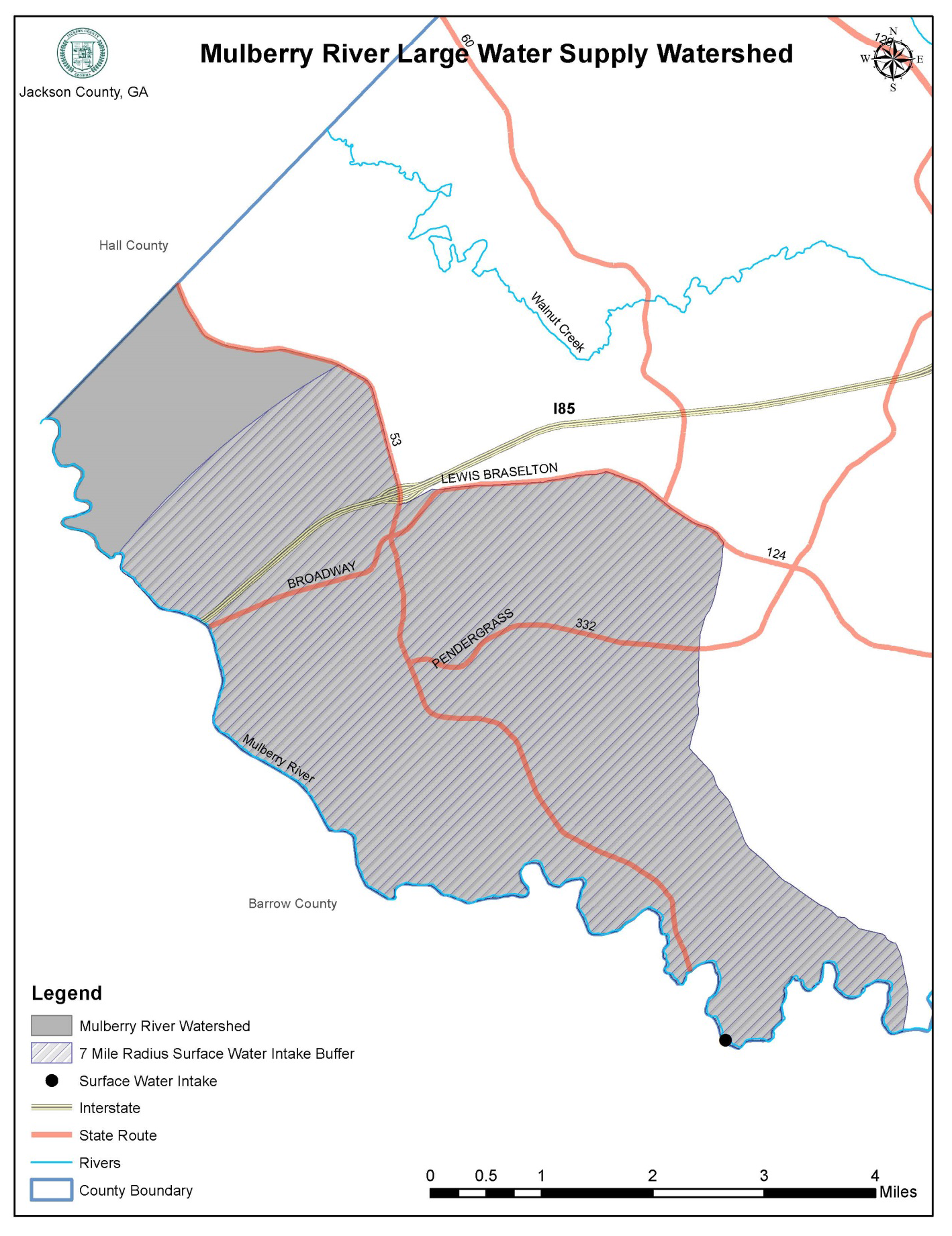
Mulberry River Large Water Supply Watershed
Bear Creek Reservoir Small Water Supply Watershed
Curry Creek Reservoir Small Water Supply Watershed
Grove Creek Reservoir Small Water Supply Watershed
Sandy Creek Reservoir Small Water Supply Watershed
Parks Creek Reservoir Small Water Supply Watershed
Significant Groundwater Recharge Areas
Protected Wetlands
(Ord. No. 17-003, § 1, 10-2-2017)
Sec. 502. - Boundaries and interpretation.
(a)
The boundaries of the environmental overlay districts established in this article shall be shown on the official zoning map adopted per section 201 of this UDC, or via a separate map made a part of the official zoning map. Whether shown on the official zoning map or on a separate environmental overlay district map or maps, environmental overlay district boundaries are and shall be considered an integral part of the official zoning map.
(b)
If an environmental overlay district regulation specifically describes the boundaries of an environmental overlay district, then the specific description regarding that environmental overlay district shall apply.
(c)
All applicable provisions regarding the official zoning map provided in article 2 of this UDC shall be considered applicable to environmental overlay districts, including but not limited to, provisions regarding determination and interpretation of zoning district boundaries, as provided in section 204 and section 205 of this UDC respectively, which may be considered applicable by the public development director in the determination and interpretation of environmental overlay district boundaries.
(Ord. No. 17-003, § 1, 10-2-2017)
Sec. 503. - Amendment of boundaries.
The boundaries of any environmental overlay district may be amended from time to time, following the same requirements and procedures of this UDC for an amendment to the official zoning map to change an underlying zoning district (See article 13 of this UDC).
(Ord. No. 17-003, § 1, 10-2-2017)
Sec. 504. - Relationship to underlying zoning district and other overlay districts.
(a)
The requirements of any environmental overlay district established by this article are in addition to the regulations established for the zoning districts (article 2) and overlay districts (article 4), if applicable, in which a given property is located.
(b)
In any case where the requirements of an environmental overlay district conflict with requirements of an applicable zoning district, another overlay district where applicable, or any other provision of this UDC, the requirements of the more restrictive section or provision shall apply.
(Ord. No. 17-003, § 1, 10-2-2017)
Sec. 505. - Definitions.
Acre-foot: The volume (as of irrigation water) that would cover one acre to a depth of one foot.
Aquifer: Any stratum or zone of rock beneath the surface of the earth capable of containing or producing water from a well. (Note: this is the same definition as in the Georgia Groundwater Use Act).
Buffer: A natural or enhanced vegetated area with no or limited minor land disturbances, such as trails and picnic areas.
DRASTIC: The standardized system for evaluating groundwater pollution potential using the hydrogeologic settings described in U.S. Environmental Protection Agency document EPA-600/2-87-035. (Note: the DRASTIC methodology is the most widely used technique for evaluation pollution susceptibility).
Hazardous waste: Any solid waste which has been defined as a hazardous waste in regulations, promulgated by the administrator of the United States Environmental Protection Agency pursuant to the federal act, which are in force and effect on February 1, 1988, codified as 40 C.F.R. section 261.3. (Note: This is the same definition as used in the Georgia Hazardous Waste Management Act.)
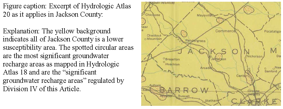
Hydrologic Atlas 18: A map prepared by the Georgia Department of Natural Resources (DNR) and published by the Georgia Geologic Survey in 1989, which identifies the most significant groundwater recharge areas of Georgia as spotted areas labeled as "areas of thick soils."
Hydrologic Atlas 20: A multicolored map of Georgia at a scale of 1:500,000, prepared by the Georgia Department of Natural Resources using the DRASTIC methodology and published by the Georgia Geologic Survey in 1992, which shows areas of high, average (or medium), and low susceptibility of groundwater to pollution in Georgia. This map is also commonly known as the Groundwater Pollution Susceptibility Map of Georgia.
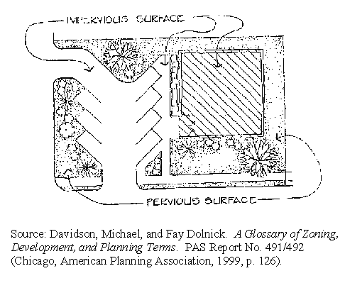
Impervious surface: A man-made structure or surface which prevents the infiltration of storm water into the ground below the structure or surface. Examples are buildings, roads, driveways, parking lots, decks, swimming pools, and patios.
Land-disturbing activity: Any grading, scraping, excavating, or filling of land; clearing of vegetation; and any construction, rebuilding, or alteration of a structure. Land-disturbing activity shall not include activities such as ordinary maintenance and landscaping operations, individual home gardens, yard and grounds upkeep, repairs, additions or minor modifications to a single-family dwelling, and the cutting of firewood for personal use.
Perennial stream: A stream which flows throughout the whole year as indicated on a United States Geological Survey (USGS) quadrangle map (seven and one-half minute topographic map prepared at a scale of 1:24,000).
Pollution susceptibility: The relative vulnerability of an aquifer to being polluted from spills, discharges, leaks, impoundments, applications of chemicals, injections and other human activities in a recharge area.
Pollution susceptibility maps: Maps of relative vulnerability to pollution prepared by the Georgia Department of Natural Resources, using the DRASTIC methodology. Pollution susceptibility maps categorize the land areas of the state into areas having high, medium and low groundwater pollution potential. This mapping has been formalized as Hydrologic Atlas 20.
Protected river: Any perennial river or watercourse with an average annual flow of at least 400 cubic feet per second as determined by appropriate U.S. Geological Survey documents; and any river identified in this article as a protected river. For purposes of this article, within unincorporated Jackson County the Middle Oconee River, the North Oconee River, and the Mulberry River are hereby defined as protected rivers.
Recharge area: Any portion of the earth's surface where water infiltrates into the ground to replenish an aquifer.
Reservoir boundary: The edge of a water supply reservoir defined by its normal pool level.
River bank: The rising ground, bordering a river, which serves to confine the water to the natural channel during the normal course of flow.
River corridor: All land, inclusive of islands, in areas of a protected river and being within 100 feet horizontally on both sides of the river as measured from the river banks. Because river channels move due to natural processes such as meandering, river bank erosion, and jumping of channels, the river corridor may shift with time. Also, the area between the top of the bank and the edge of the river shall be considered part of a river corridor, even though it is not measured for purposes of establishing river corridor buffers.
Sensitive natural areas: Any area, as identified now or hereafter by the Georgia Department of Natural Resources, which contains one or more of the following: habitat, including nesting sites, occupied by rare or endangered species; rare or exemplary natural communities; significant landforms, hydroforms, or geological features; or other areas so designated by the Georgia Department of Natural Resources; and which is sensitive or vulnerable to physical or biological alteration.
Significant recharge areas: Those areas mapped by the Georgia Department of Natural Resources in Hydrologic Atlas 18 (1989 edition). Mapping of recharge areas is based on outcrop area, lithology, soil type and thickness, slope, density or lithologic contacts, geologic structure, the presence of karst, and potentiometric surfaces.
Single-family dwelling: A dwelling structure that is designed for the use of one family or one household.
Utility: Public or private water or sewer piping systems, water or sewer pumping stations, electric power lines, fuel pipelines, telephone lines, roads, driveways, bridges, river/lake access facilities, storm water systems and railroads or other utilities identified by Jackson County.
Water supply reservoir: A governmentally owned impoundment of water for the primary purpose of providing water to one or more governmentally owned public drinking water systems. This excludes the multipurpose reservoirs owned by the U.S. Army Corps of Engineers.
Water supply watershed: The area of land upstream of a governmentally owned public drinking water intake. Water supply watersheds are classified as small (less than 100 square miles within the drainage basin above the drinking water intake) and large (100 square miles or more within the drainage basin above the drinking water intake).
Water supply watershed protection plan: A land use and environmental protection plan prepared and adopted by a local government for the protection of the quality of drinking water obtained from the watershed.
Wetlands: Freshwater areas that are inundated or saturated by surface or groundwater at a frequency and duration sufficient to support, and that under normal circumstances do support, a prevalence of vegetation typically adapted for life in saturated soil conditions. Wetlands generally include swamps, marshes, bogs and similar freshwater areas.
Wetland, protected: Those wetlands identified on the protected wetlands environmental overlay district map, which are based on best available information including but not limited to National Wetlands Inventory maps prepared by the U.S. Fish and Wildlife Service. Areas approved by the U.S. Army Corps of Engineers based on studies prepared by a competent professional shall be considered a protected wetland, whether or not such wetland area is shown on the protected wetlands environmental overlay district map. Any new wetland area constructed as a best management practice for stormwater control shall also be considered a protected wetland once construction is complete, whether or not such wetland area is shown on the protected wetlands environmental overlay district map.
(Ord. No. 17-003, § 1, 10-2-2017)
Sec. 506. - Mitigation of violation.
When a building or other structure has been constructed in violation of this article, the violator shall be required to remove the building or structure. When removal of vegetative cover, or excavation or fill has taken place in violation of this article, the violator shall be required to restore the affected land to its original contours and to restore vegetation, as far as practicable.
(Ord. No. 17-003, § 1, 10-2-2017)
Sec. 511. - Authority.
This division is adopted to implement the requirements of section 391-3-16-.04, "Criteria for River Corridor Protection" of the Rules of the Georgia Department of Natural Resources, Environmental Protection Division, chapter 391-3-16, "Rules for Environmental Planning Criteria." Said rules were adopted under the authority of O.C.G.A. § 12-2-8 (as amended).
(Ord. No. 17-003, § 1, 10-2-2017)
Sec. 512. - Findings.
(a)
River corridors, or those strips of land that flank major rivers in Georgia, are of vital importance to Georgia in that they help preserve those qualities that make a river suitable as a habitat for wildlife, a site for recreation, and a source for clean drinking water. River corridors also allow the free movement of wildlife from area to area within the state, help control erosion and river sedimentation, and help absorb flood waters. The method mandated in O.C.G.A. § 12-2-8 for the protection of river corridors is the establishment of natural vegetative buffer areas bordering each protected river.
(b)
In preparing and adopted river corridor plans, the Jackson County Board of Commissioners finds that it is appropriate to designate river corridors along the Middle Oconee River, North Oconee River, and Mulberry River, even though one or more of these rivers may not meet the minimum water flow specification in cubic feet per second, defining a protected river by state rule.
(Ord. No. 17-003, § 1, 10-2-2017)
Sec. 513. - Establishment.
There are hereby established river corridors along both sides of the Middle Oconee River, the North Oconee River, and the Mulberry River in unincorporated Jackson County, as shown on the environmental overlay districts map. Each of these river corridors shall be considered a separate environmental overlay district, although the regulations are the same for each river corridor designated per this article.
(Ord. No. 17-003, § 1, 10-2-2017)
Sec. 514. - Applicability.
(a)
Unless specifically exempted by this division, these regulations shall apply to all river corridors, as defined and as established in this division, (i.e., within 100 feet of both sides of the river banks along the Middle Oconee River, the North Oconee River, and the Mulberry River) in unincorporated Jackson County.
(b)
This division shall apply to all private lands and to all state owned or administered land that contains a protected river within its boundaries. All state agencies shall comply with the requirements of this division. Failure by a state agency to comply with such requirements shall be considered an indicator of a governmental action which may significantly adversely affect the quality of the environment under the Environmental Policy Act (O.C.G.A. 12-16-1 et seq.).
(Ord. No. 17-003, § 1, 10-2-2017)
Sec. 515. - Exemptions.
(a)
Land uses existing prior to the initial adoption by Jackson County of river corridor regulations shall be exempt from the requirements of this division; provided, however, that any expansion in land area or building area of such existing land use shall not be exempt from the requirements of this division.
(b)
Although a use may be exempt from this division, any such use shall not impair the drinking quality of the river water and must in compliance with all local, state and federal environmental rules and regulations.
(Ord. No. 17-003, § 1, 10-2-2017)
Sec. 516. - Natural vegetative buffer required.
(a)
Within river corridors established in this division, there shall be maintained a natural vegetative buffer for the entire width of the river corridor, except as otherwise provided in this division. For purposes of this division, the river corridor and the required river buffer are the same width (i.e., 100 feet in width from the river banks).
(b)
For purposes of this division "natural vegetative buffer" or "buffer area" means a river corridor containing the flora native to that area. The natural floras for specific areas are described in Georgia Geologic Survey Bulletin 114, "The Natural Environments of Georgia." Habitats for endangered and threatened species may require human management of the river corridor in order to maintain those species.
(Ord. No. 17-003, § 1, 10-2-2017)
Sec. 517. - Uses permitted in river corridors.
The following uses shall be permitted in river corridors/river buffers:
(a)
Agricultural production and management, provided that it shall be consistent with best management practices established by the Georgia Soil and Water Conservation Commission, all state and federal laws, and all regulations promulgated by the Georgia Department of Agriculture and shall not impair the drinking quality of the river water as defined by the federal Clean Water Act, as amended.
(b)
Single-family dwellings, including the usual appurtenances, subject to compliance with the following requirements:
1.
The dwelling shall be in compliance with all other requirements of this UDC.
2.
The dwelling shall be located on a tract of land containing at least two acres. For the purposes of this subsection, the size of the tract of land shall not include any area that lies within the protected river (that is, for tracts of land that include portions of a protected river, the area between the river banks cannot be counted towards the two-acre minimum size).
3.
There shall be only one such dwelling on each two-acre or larger tract of land.
4.
Septic tanks and septic tank drainfields shall not be located within the buffer area.
(c)
Timber production and harvesting, subject to the following conditions: Forestry activity shall be consistent with best management practices established by the Georgia Forestry Commission; and forestry activity shall not impair the drinking quality of the river water as defined by the federal Clean Water Act, as amended.
(d)
Wildlife and fisheries management activities consistent with the purposes of O.C.G.A. 12-2-8.
(e)
Waste-water treatment.
(f)
Recreational usage consistent either with the maintenance of a natural vegetative buffer or with river-dependent recreation. This includes a boat ramp, paths, and walkways, but excludes hard-surface tennis courts and parking lots.
(g)
Natural water quality treatment or purification.
(h)
Utilities, if such utilities cannot feasibly be located outside the buffer area, provided that: the utilities shall be located as far from the river bank as reasonably possible; and provided the utilities are installed and maintained such as to protect the integrity of the buffer area as well as is reasonably possible and shall not impair the drinking quality of the river water. Construction of any road or utility crossing a river corridor, is permitted, provided that it shall meet all requirements of the Georgia Erosion and Sedimentation Control Act of 1975, as amended, and any applicable requirements of this UDC including but not limited to soil erosion and sedimentation control.
(i)
Other uses permitted by the Georgia Department of Natural Resources or under section 404 of the Clean Water Act.
(Ord. No. 17-003, § 1, 10-2-2017)
Sec. 518. - Uses prohibited in river corridors.
The following uses shall be prohibited within river corridors:
(a)
Septic tanks and septic tank drain fields, except as specifically authorized by section 517 of this UDC for single-family dwellings.
(b)
Handling areas for the receiving and storage of hazardous waste.
(c)
Hazardous waste or solid waste landfills.
(d)
All construction within the buffer area shall be prohibited unless specifically authorized in this division.
(Ord. No. 17-003, § 1, 10-2-2017)
Sec. 519. - Vegetative buffer restoration after disturbance.
The natural vegetative buffer shall be restored as quickly as possible following any land-disturbing activity within the river corridor.
(Ord. No. 17-003, § 1, 10-2-2017)
Sec. 521. - Authority.
This division is adopted to implement the requirements of section 391-3-16-.01, "Criteria for Water Supply Watersheds" of the Rules of the Georgia Department of Natural Resources, Environmental Protection Division, chapter 391-3-16, "Rules for Environmental Planning Criteria." Said rules were adopted under the authority of O.C.G.A. § 12-2-8 (as amended).
(Ord. No. 17-003, § 1, 10-2-2017)
Sec. 522. - Findings.
The quality of public drinking water supplies deserves protection. Land-disturbing activities associated with development can increase erosion and sedimentation, which threaten the storage capacity of reservoirs and impair the quality of public drinking water supplies. Stormwater runoff, particularly from impervious surfaces, can introduce toxins, nutrients, and sediments into drinking water supplies, making water treatment more complicated and expensive, and rendering water resources unusable for recreation and other uses. Industrial land uses that involve the manufacture, use, transport, and storage of hazardous or toxic waste materials result in potential risks of contamination of nearby public drinking water supplies. Therefore, land use activities within water supply watersheds require regulation to ensure that public water supplies remain clean. The regulations in this division are intended to minimize the transport of pollutants and sediment to water supplies, to maintain the yield of water supply watersheds, and to ensure water can be treated to meet federal and state drinking water standards.
(Ord. No. 17-003, § 1, 10-2-2017)
Sec. 523. - Establishment.
There are hereby established water supply watershed environmental overlay districts in unincorporated Jackson County, as identified in section 501 of this article, as shown on the environmental overlay districts map, and as described further in this section. Each of these watersheds shall be considered a separate environmental overlay district.
(a)
Middle Oconee River. The Middle Oconee River water supply watershed lies upstream of a public drinking water intake in Athens-Clarke County, which extends into unincorporated Jackson County. It is a "large" water supply watershed.
(b)
North Oconee River. The North Oconee River water supply watershed lies upstream of a public drinking water intake in Athens-Clarke County, which extends into unincorporated Jackson County. It is a "large" water supply watershed.
(c)
Mulberry River. The Mulberry River water supply watershed lies upstream of a public drinking water intake in City of Winder, which extends into unincorporated Jackson County. It is a "large" water supply watershed.
(d)
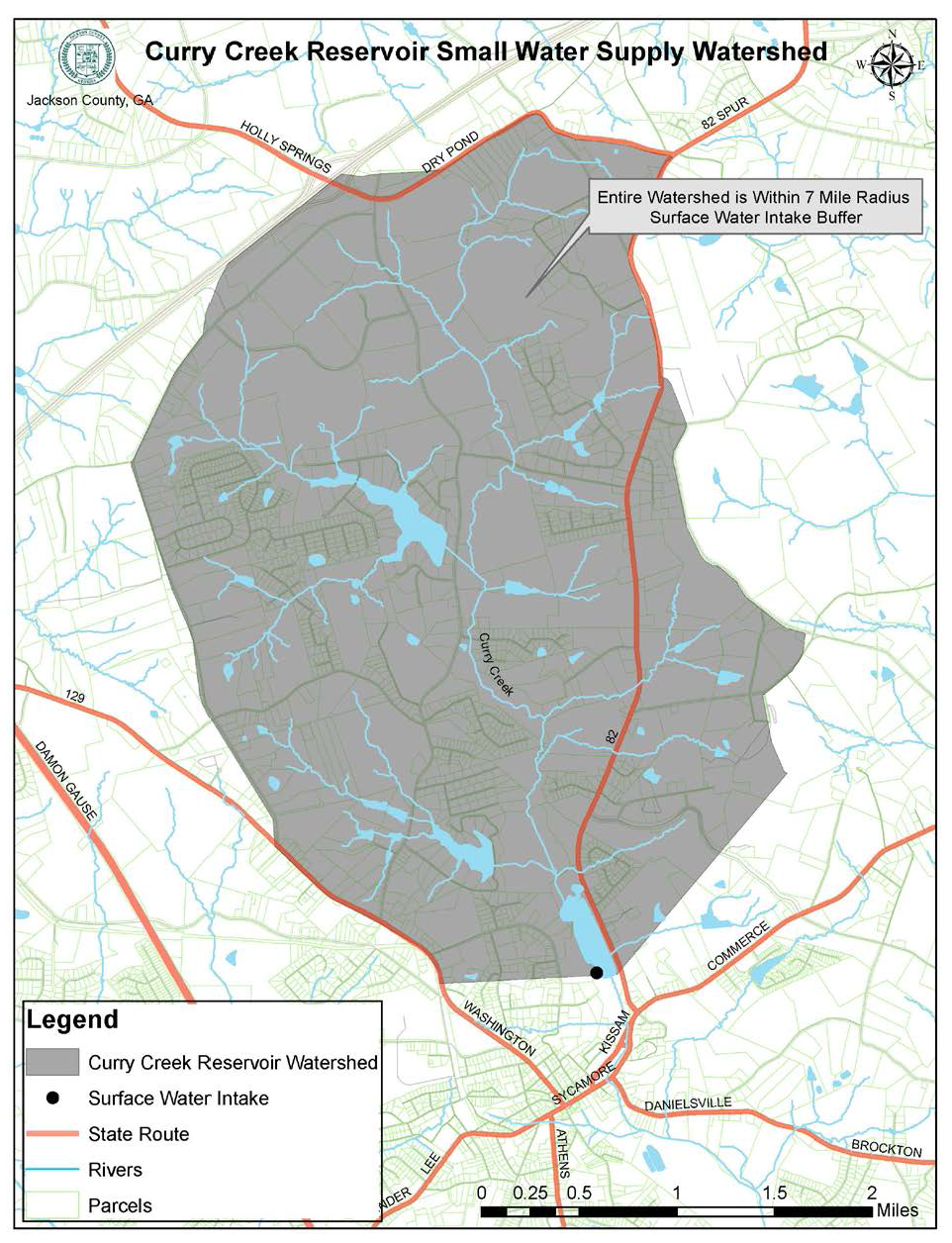
Curry Creek. The public drinking water intake for this watershed is for the Curry Creek reservoir in the City of Jefferson. The watershed is partially within the City of Jefferson and extends into unincorporated Jackson County. It is a "small" water supply watershed.
(e)
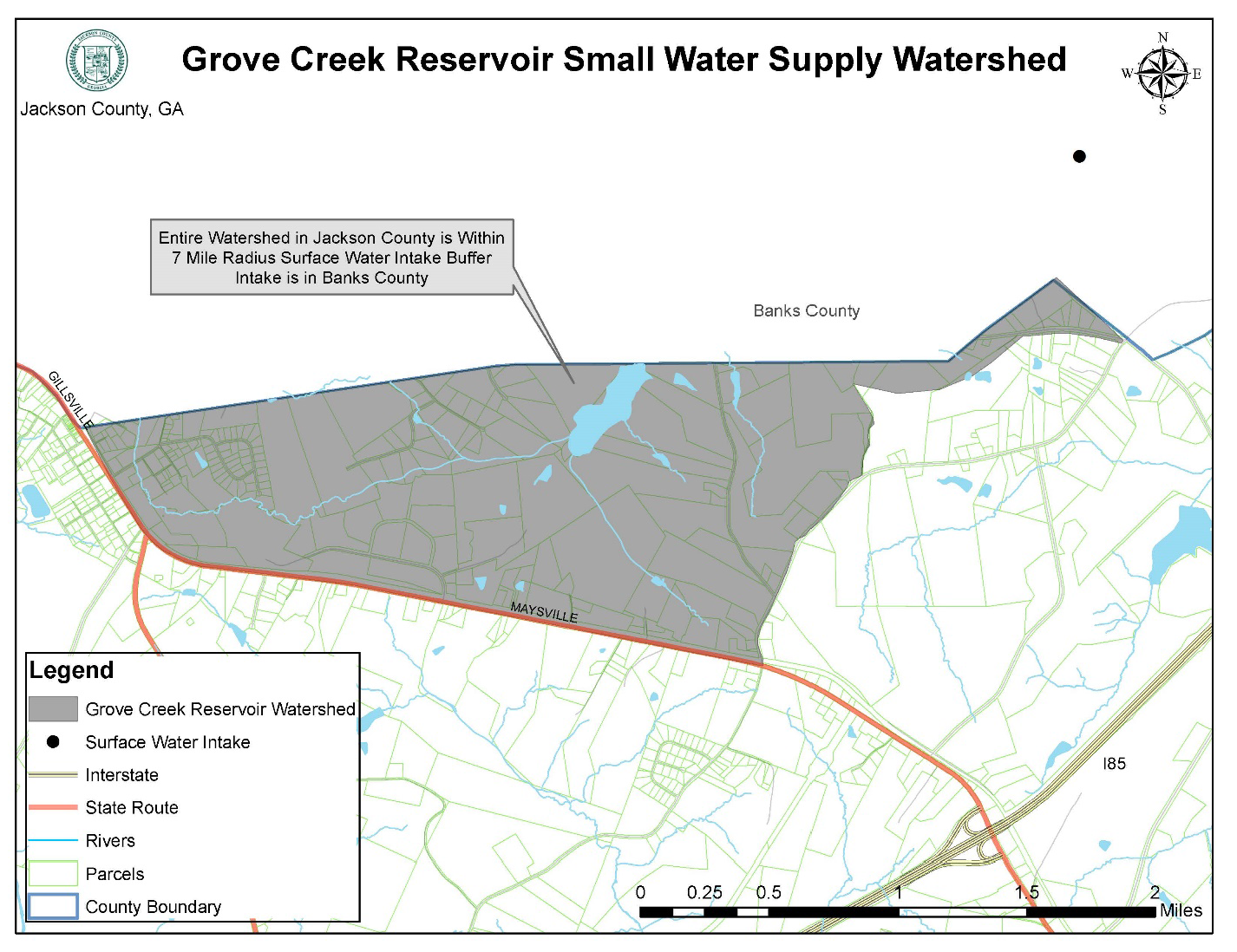
Grove Creek. The public drinking water intake for this watershed is on the Grove Creek Reservoir in Banks County. The watershed extends into a part of unincorporated Jackson County. It is a "small" water supply watershed.
(f)
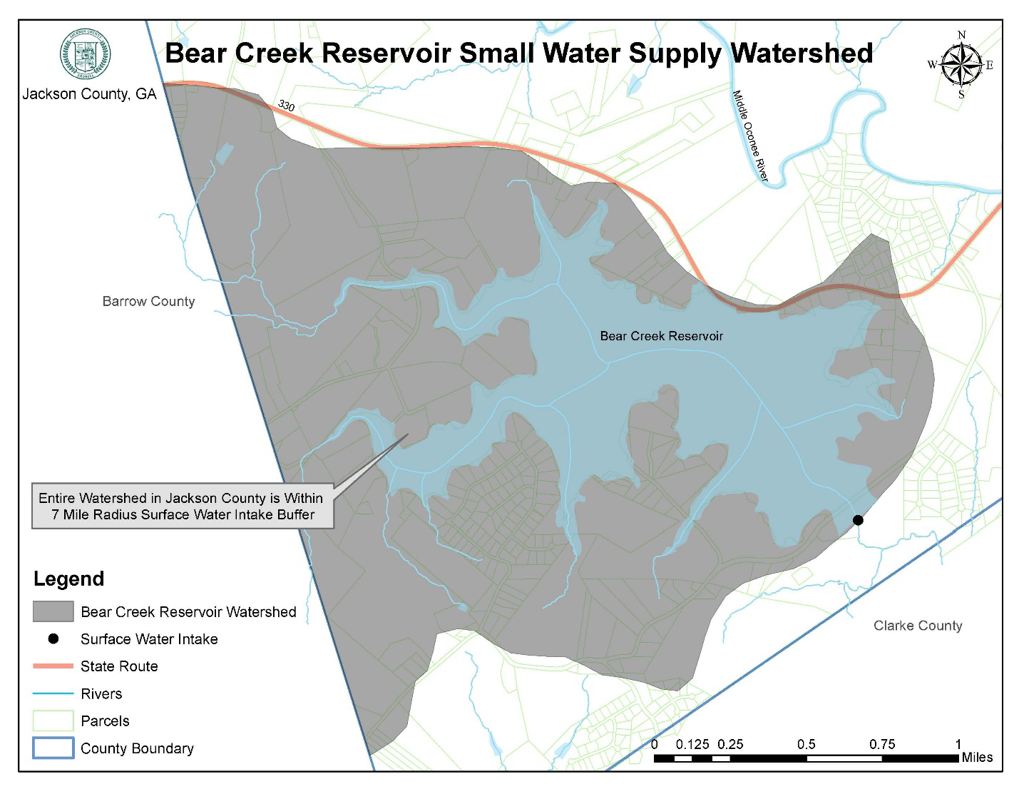
Bear Creek. The public drinking water intake for this watershed is on the Bear Creek Reservoir in unincorporated Jackson County. The watershed extends into Barrow County and unincorporated Jackson County. It is a "small" water supply watershed.
(g)
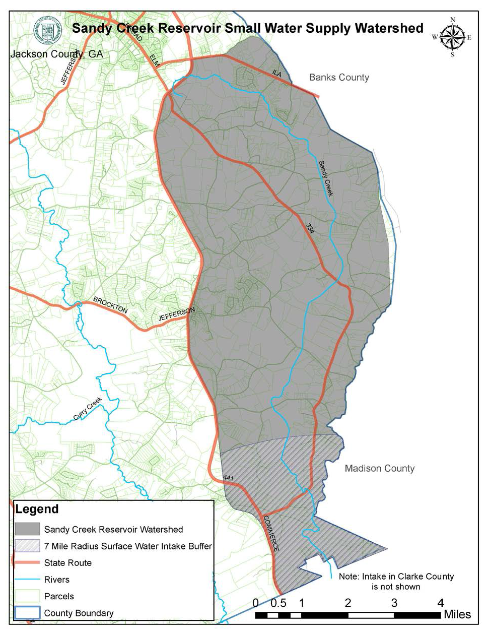
Sandy Creek. The public drinking water intake for this watershed is on Sandy Creek in Athens-Clarke County. The watershed extends into unincorporated Jackson County. It is a "small" water supply watershed.
(h)
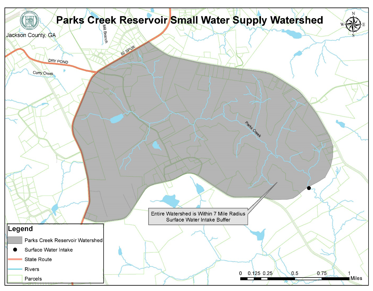
Parks Creek. A proposed water intake for the City of Jefferson is located on Parks Creek in unincorporated Jackson County. The watershed extends into unincorporated Jackson County. It is a "small" water supply watershed.
(Ord. No. 17-003, § 1, 10-2-2017)
Sec. 524. - Applicability.
No land shall be disturbed and no use shall be established unless it is consistent with the requirements of this division, except as otherwise specifically exempted from the requirements of this division.
(Ord. No. 17-003, § 1, 10-2-2017)
Sec. 525. - Exemptions.
(a)
Existing land uses. Land uses existing prior to the initial adoption of water supply watershed protection regulations by Jackson County are exempt from the requirements of this division.
(b)
Utilities. Utilities are exempt from the stream corridor and impervious surface setback area provisions of this division if the utilities to be located in the buffer or impervious surface setback areas cannot feasibly be located outside these areas, subject to the following requirements:
1.
The utilities shall be located as far from the stream bank as reasonably possible.
2.
The installation and maintenance of the utilities shall be such to protect the integrity of the buffer and setback areas as best as reasonably possible.
3.
The utilities shall not impair the quality of the drinking water stream.
(c)
Forestry and agriculture. Forestry and agricultural activities are exempt from the stream corridor buffer and impervious surface setback area provisions of this division, provided that such activities shall be consistent with best management practices established by the Georgia Forestry Commission or the Georgia Department of Agriculture and shall not impair the quality of the drinking water stream.
(Ord. No. 17-003, § 1, 10-2-2017)
Sec. 526. - Regulations for large water supply watersheds.
Stream corridors of all perennial streams in all large water supply watersheds tributary to a water supply reservoir within a seven-mile radius of a reservoir boundary are protected by criteria specified in this section. Where the requirements of this section are more restrictive than the requirements imposed for river corridors as specified in division II of this article, the more restrictive requirements of this section shall apply.
(a)
Buffer. A buffer shall be maintained for a distance of 100 feet on both sides of the stream as measured from the stream banks.
(b)
Impervious surface setback. No impervious surface shall be constructed within a 150-foot setback area on both sides of the stream as measured from the stream banks.
(c)
Septic tanks and drainfields. Septic tanks and septic tank drainfields are prohibited in the impervious surface setback area.
(d)
Hazardous materials. Facilities which handle hazardous materials of the types and amounts determined by the Georgia Department of Natural Resources, if authorized to be located within seven miles of a water supply intake or water supply reservoir, shall perform their operations on impermeable surfaces having spill and leak collection systems as prescribed by the Georgia Department of Natural Resources.
(Ord. No. 17-003, § 1, 10-2-2017)
Sec. 527. - Regulations for small water supply watersheds.
Stream corridors of all perennial streams within a small water supply watershed tributary to a water supply reservoir are protected by criteria specified in this section. Where the requirements of this section are more restrictive than the requirements imposed for river corridors as specified in Division II of this article, the more restrictive requirements of this section shall apply.
(a)
Buffers and impervious surface setbacks. A buffer shall be maintained for a specified distance on both sides of the stream as measured from the stream banks, and no impervious surface shall be constructed within a specified setback area on both sides of the stream as measured from the stream banks, as follows:
(b)
Septic tanks and drainfields. Septic tanks and septic tank drainfields are prohibited in the impervious surface setback required by this section.
(c)
Sanitary landfills. New sanitary landfills are allowed in a small water supply watershed only if they have synthetic liners and leachate collection systems.
(d)
Hazardous waste. New hazardous waste treatment or disposal facilities are prohibited.
(e)
Hazardous materials. Facilities which handle hazardous materials of the types and amounts determined by the Georgia Department of Natural Resources, if authorized to be located within seven miles of a water supply intake or water supply reservoir, shall perform their operations on impermeable surfaces having spill and leak collection systems as prescribed by the Georgia Department of Natural Resources.
(f)
Maximum impervious surface areas by land use.
1.
Intent. It is the intent of this subsection that the impervious surface area, including all public and private structures, utilities, or facilities, of the entire small water supply watershed shall be limited to 25 percent. Due to the fact that small water supply watersheds extend into areas other than unincorporated Jackson County and are outside the regulatory authority of the Jackson County Board of Commissioners, a watershed-wide limit is not currently enforceable without an intergovernmental agreement and more careful study of existing land uses in the watershed. To meet the intent of this subsection with regard to watershed-wide impervious surface limitations is met, there are hereby established maximum impervious surface limits by land use.
2.
Applicability. The limitations on total impervious surface area of this subsection apply on a lot-by-lot basis or any portion of a lot within a small water supply watershed except as otherwise provided in this subsection for subdivisions. In the case of a lot only partially located within a small water supply watershed boundaries, impervious surface should be concentrated on that portion of the lot outside of the watershed where possible.
3.
Demonstration of compliance. To ensure compliance with this subsection, the public development director may require a numerical estimate and graphical depiction of impervious cover areas be prepared by a registered land surveyor or other qualified professional.
4.
Maximum impervious surface. Development within a small water supply watershed shall not exceed the following maximum impervious surface limitations for the respective land use as determined by the public development director, except as specifically provided otherwise in this subsection.
5.
Single-family residential subdivisions. When a residential subdivision for detached, single-family dwellings is proposed on land within a small water supply watershed, the applicant shall demonstrate compliance with the 25 percent maximum impervious surface requirement for the land within the entire subdivision. Roads, sidewalks, and other impervious surfaces within public rights-of-way shall be calculated and the total impervious area shown on the final recorded subdivision plat. A maximum impervious surface for each lot shall be established and shown on the final recorded subdivision plat. Lot development within the subdivision shall not exceed the maximum impervious surface as indicated on the final recorded subdivision plat. Compliance with this section may require that conservation areas be set aside or lots be larger in area than required by the zoning district in which the lots are located.
6.
Exceptions for water quality enhancement or low impact development. Upon application, the public development director may approve increases in the maximum impervious surface area limitations of this subsection, if the land development incorporates and implements water quality enhancement or low impact development techniques as described in article 11 of this UDC. Such increase authorized shall not exceed 125 percent of the maximum impervious surface percentage established in this subsection.
7.
Pervious pavements. Pervious pavements, where approved and utilized, shall not count as impervious surfaces for purposes of compliance with this subsection.
(Ord. No. 17-003, § 1, 10-2-2017)
Sec. 528. - Water supply reservoir buffers.
A natural vegetative buffer shall be established and maintained within 150 feet of the banks of Bear Creek Reservoir and Parks Creek Reservoir in unincorporated Jackson County. Vegetation, land disturbance and land uses shall be controlled by the provisions of the applicable reservoir management plan, as approved by the Georgia Department of Natural Resources.
(Ord. No. 17-003, § 1, 10-2-2017)
Sec. 531. - Authority.
This division is adopted to implement the requirements of section 391-3-16-.02, "Criteria for the Protection of Groundwater Recharge Areas" of the Rules of the Georgia Department of Natural Resources, Environmental Protection Division, chapter 391-3-16, "Rules for Environmental Planning Criteria." Said rules were adopted under the authority of O.C.G.A. § 12-2-8 (as amended).
(Ord. No. 17-003, § 1, 10-2-2017)
Sec. 532. - Findings.
(a)
It is essential to the health, safety, and welfare of the public that the quality of subsurface public drinking water be maintained. Groundwater resources exist in underground reservoirs known as aquifers. These aquifers are zones of rock beneath the earth's surface that are capable of providing water for a well. They occupy vast regions of the subsurface and are replenished by infiltration of surface water runoff in zones of the surface, known as groundwater recharge areas. Groundwater is susceptible to contamination when development occurs within groundwater recharge areas.
(b)
Certain land use activities, such as septic tanks, underground tanks, and chemical spills, pose a significant threat to the quality of groundwater supplies. Therefore, it is necessary to manage land uses within groundwater recharge areas in order to ensure that pollution threats and development impacts are minimized. To this end, this UDC establishes minimum lot sizes to provide for the orderly and safe development of property utilizing on-site sewage management systems.
(c)
Recharge area protection criteria of the state are based on the state's hydrogeology. Recharge area protection within significant recharge areas has been refined by the state based on high, medium, and low susceptibility or vulnerability to human induced pollution.
(d)
Each significant groundwater recharge area mapped by the state within the boundaries of Jackson County, Georgia, as shown on Hydrologic Atlas 18, are within lower pollution susceptibility areas as shown on Hydrologic Atlas 20. This makes state criteria regarding medium and higher pollution susceptibility inapplicable in Jackson County and such criteria are properly excluded from this division.
(Ord. No. 17-003, § 1, 10-2-2017)
Sec. 533. - Adoption by reference of hydrologic atlases.
Hydrologic Atlas 18 and Hydrologic Atlas 20 are hereby adopted for purposes of applying the state's environmental planning criteria for significant groundwater recharge areas.
(Ord. No. 17-003, § 1, 10-2-2017)
Sec. 534. - Establishment.
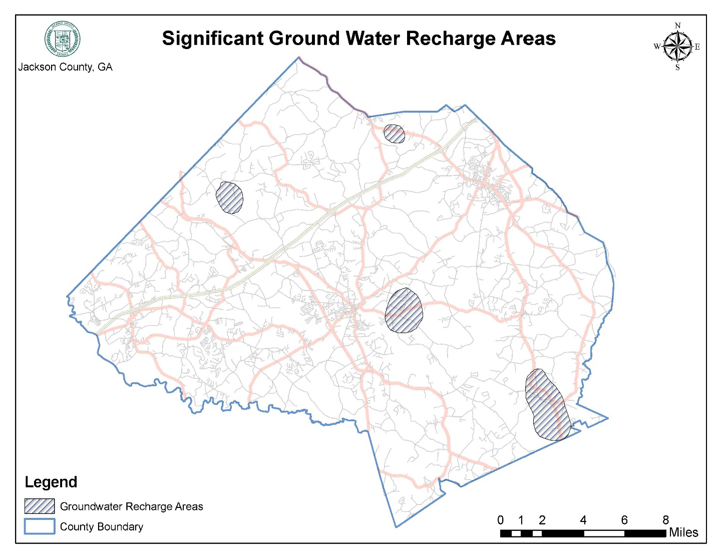
There are hereby established significant groundwater recharge areas in Jackson County as established by state rule, as shown on the significant groundwater recharge area environmental overlay district map, and as further described in this division.
(Ord. No. 17-003, § 1, 10-2-2017)
Sec. 535. - Applicability.
(a)
This division shall apply to all unincorporated lands within Jackson County that are mapped as significant recharge areas as defined by this article.
(b)
No land shall be disturbed and no use shall be established within an area regulated by this division, unless it is consistent with the requirements of this division.
(Ord. No. 17-003, § 1, 10-2-2017)
Sec. 536. - Regulations for significant groundwater recharge areas.
The following criteria shall apply in significant recharge areas established by this division:
(a)
New agricultural waste impoundment sites. New agricultural waste impoundment sites exceeding 50 acre-feet shall be lined. As a minimum, the liner shall be constructed of compacted clay having a thickness of one-foot and a vertical hydraulic conductivity of less than 5 x 10⁻⁷ centimeters/second or other criteria established by the U.S. Soil Conservation Service.
(b)
Minimum lot size. New homes or lot divisions for homes or other uses and served by septic tank/drain field systems shall be on lots having a minimum lot size of at least one hundred ten percent of the minimum size identified on table MT-1 of the Georgia Department of Human Resources' Manual for On-Site Sewage Management Systems (hereinafter "DHR Table MT-1"); provided, however, that any lot of record existing on the date of initial adoption of significant groundwater recharge area regulations by Jackson County shall be exempt from the minimum lot size established by this paragraph. No construction may proceed on a home to be served by a septic tank unless the Jackson County Environmental Health Department first approves the proposed septic tank installation as meeting the requirements of the Georgia Department of Human Resources' Manual for On-Site Sewage Management Systems.
(c)
Hazardous material handling and hazardous waste. New facilities permitted or to be permitted to treat, store, or dispose of hazardous waste shall perform such operations on an impermeable pad having a spill and leak collection system. New facilities which handle hazardous materials of types and in amounts determined by the Georgia Department of Natural Resources, shall perform their operations on impermeable surfaces having spill and leak collection systems, as prescribed by Georgia Department of Natural Resources. Land disposal of hazardous waste is prohibited in any area regulated by this division.
(d)
Above-ground storage tanks. New above-ground chemical or petroleum storage tanks, having a minimum volume of 660 gallons, shall have secondary containment for 110 percent of the volume of such tanks or 110 percent of the volume of the largest tank in a cluster of tanks. (Note: These figures are consistent with US EPA rules for oil pollution prevention, 40 CFR 112.1). Such tanks used for agricultural purposes are exempt, provided they comply with all federal requirements.
(e)
Sanitary landfills. Sanitary landfills are prohibited in any area regulated by this division.
(Ord. No. 17-003, § 1, 10-2-2017)
Sec. 541. - Authority.
This division is adopted to implement the requirements of section 391-3-16-.03, "Criteria for Wetlands Protection" of the Rules of the Georgia Department of Natural Resources, Environmental Protection Division, chapter 391-3-16, "Rules for Environmental Planning Criteria." Said rules were adopted under the authority of O.C.G.A. § 12-2-8 (as amended).
(Ord. No. 17-003, § 1, 10-2-2017)
Sec. 542. - Findings.
Wetlands are indispensable and fragile natural resources with significant development constraints due to flooding, erosion, and soils limitations. In their natural state, wetlands serve man and nature. They provide habitat areas for fish, wildlife and vegetation; water quality maintenance and pollution control; flood control; erosion control; natural resource education; scientific study; and open space and recreational opportunities.
(Ord. No. 17-003, § 1, 10-2-2017)
Sec. 543. - Establishment.
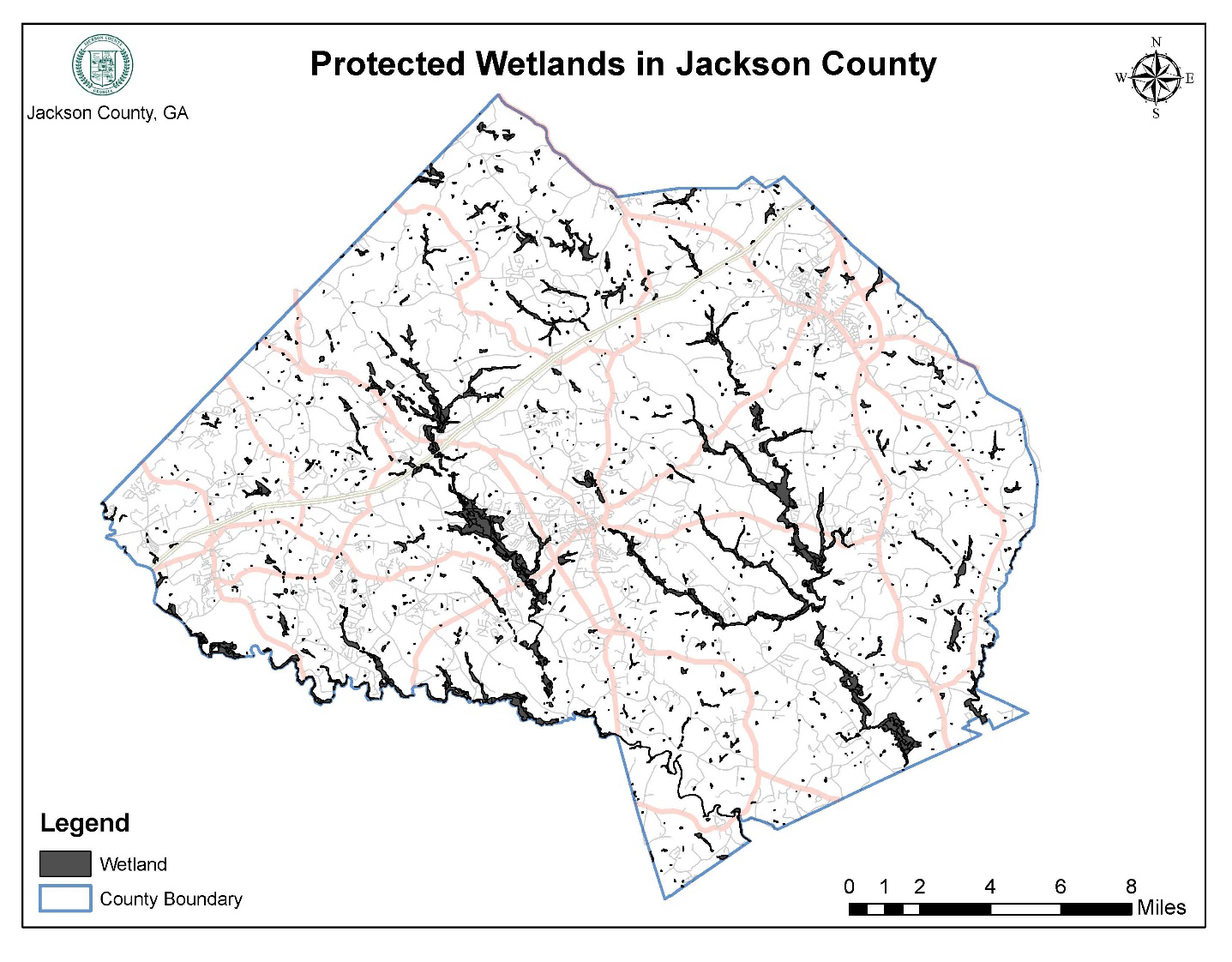
There are hereby established protected wetlands in unincorporated Jackson County as shown on the protected wetlands environmental overlay district map.
(Ord. No. 17-003, § 1, 10-2-2017)
Sec. 544. - Applicability.
(a)
This division shall apply to all unincorporated lands within Jackson County that are mapped as protected wetlands as defined by this article.
(b)
No land shall be disturbed and no use shall be established within an area regulated by this division, unless it is consistent with the requirements of this division.
(c)
No development permit or building permit shall be issued by the public development department for a land use, building, structure, or manufactured home, nor shall any activity commence, unless the land use, building, structure, manufactured home or activity conforms to the requirements of this division. Prior to a development permit or building permit being issued, the public development department shall require a site plan or subdivision plat in sufficient detail to review the proposed development for compliance with the provisions of this division.
(Ord. No. 17-003, § 1, 10-2-2017)
Sec. 545. - Relationship to federal regulation.
(a)
The wetlands permit program under section 404 of the Clean Water Act provides a federal permit process that may allow activities in wetlands after a public interest review. Most activities in wetlands will require a section 404 permit from the U.S. Army Corps of Engineers. If wetlands are altered or degraded, mitigation to offset losses will be required as a condition of a section 404 permit. Under current federal policy, alterations or degradations of wetlands should be avoided unless it can be demonstrated that there will be no long-term adverse impacts or net loss of wetlands. Section 401 of the Clean Water Act requires certification by the state for any permit issued under section 404. Other state and federal laws are also applicable to wetlands and wetlands protection.
(b)
The provisions of this division shall be in addition to any requirements of federal regulations.
(Ord. No. 17-003, § 1, 10-2-2017)
Sec. 546. - Permitted uses.
Only the following uses shall be permitted within a protected wetland, to the extent that they are not prohibited by any other ordinance or law, and provided they do not require structures, grading, fill, draining, or dredging except as provided herein. All other uses are prohibited within wetlands.
(a)
Conservation or preservation of soil, water, vegetation, fish and other wildlife, provided it does not affect waters of Georgia or of the United States in such a way that would require an individual 404 permit.
(b)
Outdoor passive recreational activities, including fishing, bird watching, hiking, boating, horseback riding, and canoeing.
(c)
Forestry practices applied in accordance with best management practices approved by the Georgia Forestry Commission and as specified in section 404 of the Clean Water Act.
(d)
The cultivation of agricultural crops. Agricultural activities shall be subject to best management practices approved by the Georgia Department of Agriculture.
(e)
The pasturing of livestock, provided that riparian wetlands are protected, that soil profiles are not disturbed, and that approved agricultural best management practices are followed.
(f)
Education, scientific research, and nature trails.
(Ord. No. 17-003, § 1, 10-2-2017)
Sec. 547. - Wetland statement on plans and plats.
Design professionals shall indicate wetlands and protected wetlands on all plans required for land disturbance, development, and building, and on any plats required for subdivision. The design professional that prepared the required plan or plat accompanying the permit or plat application shall provide a statement on the plan sheet or plat sheet indicating whether or not a wetland or protected wetland is located on the property.
(Ord. No. 17-003, § 1, 10-2-2017)