
Jackson County Unincorporated
City Zoning Code
City Zoning Code
ARTICLE 16
- STREETS AND SIDEWALKS
Sec. 1601. - Definitions.
AASHTO: The American Association of State Highway and Transportation Officials.
Access street, private: A private street built to standards required by this UDC and providing access to abutting properties.
Arterial, principal: A term used in the functional classification of roads. These roads, which include interstates and rural freeways: serve "substantial" statewide or interstate trips, as defined by high mileage or volume; connect most urban areas of 25,000 or more and virtually all urban areas of 50,000 or more; and provide an integrated network without stub connections except where geography dictates otherwise. Arterials are the longest roads with the highest speed limits. Principal arterials begin and end at principal arterials or interstates.
Arterial, minor: A term used in the functional classification of roads. With the principal arterial system, these roads form a rural network that links other cities, larger towns, and other traffic generators, such as major resort areas, capable of attracting travel over long distances; link all developed areas of the state; and serve corridors with trip lengths and travel density greater than those predominantly served by rural collector or local systems. Minor arterials, therefore, constitute routes whose design should be expected to provide for relatively high overall travel speeds, with minimum interference to the through-movement. Minor arterials begin and end at minor or principal arterials or interstates.
Collector, major: A term used in the functional classification of roads. These roads, with minor collectors, primarily serve the county rather than state traffic. Consequently, more moderate speeds are typical. They serve any county seat or larger town not on an arterial route, and other traffic generators of equivalent intra-county importance, such as consolidated schools, shipping points, county parks, and important mining and agricultural areas; link the latter places with nearby larger towns or cities, or arterials and freeways; and serve the more important intra-county travel corridors. Collectors are shorter roads with slower travel speeds than arterial roads. Major collectors begin and end at other major collectors, at minor or principal arterials or at interstates.
Collector, minor: A term used in the functional classification of roads. Serving county-wide traffic, these roads should evenly collect traffic from local roads and bring all developed areas within a reasonable distance of a collector road; provide service to the remaining smaller communities; and link the locally important traffic generators with the hinterlands. Minor collectors begin and end at other minor collectors or any of the higher functional classifications.
Deceleration lane: A speed-change lane, including tapered areas, for the purpose of enabling a vehicle that is making an exit turn from a roadway to slow to a safe turning speed after it has left the mainstream of faster-moving traffic. Also called a "decel lane"; it denotes a right turn lane or a left turn lane into a development or subdivision.
Functional classification of roads: A system for the classification of roads used by the Federal Highway Administration, the Georgia Department of Transportation and Jackson County. The system is based on several factors, including: the amount of traffic currently on the road plus if any new major traffic generators (e.g., new schools, new subdivisions, new community level commercial centers, or new major employers) are being built in the next four years along that roadway; the length of the roadway in comparison with the functional classification of other roads in the same area.
Grade:
(1)
The profile of the center of the roadway, or its rate of ascent or descent.
(2)
To shape or reshape an earth road by means of cutting or filling.
(3)
Elevation.
Highway: A term applied to streets and roads that are under the jurisdiction of the Georgia Department of Transportation or federal highway agency. Highways are major arteries of the circulation network, carry significant volumes of traffic for both long and short trips, and are designed with access to abutting properties with some degree of control and safe standards of design.
Horizontal alignment: Horizontal geometrics of the roadway.
Horizontal curve: A curve by means of which a road can change direction to the right or left.
Intersection: The general area where two or more roads join or cross, including the roadway and roadside facilities for traffic movements within the area.
Local road: A term used in the functional classification of roads. These roads primarily serve to provide access to adjacent land uses and serve low mileage trips as compared to collectors or other higher systems. Local roads constitute the rural mileage not classified as part of the principle arterial, minor arterial, or collector road systems. Local roads are the shortest roads with the slowest speeds when compared with other functional classifications of roads.
Left turn lane: A speed-change lane within the median to accommodate left turning vehicles.
Pavement markings: Devices or paint placed on the roadway to mark pavement for vehicular and pedestrian traffic control.
Profile: A longitudinal section of a roadway, drainage course, etc.
Right-of-way: Land reserved for and immediately available for public use as a street or other purpose.
Road: A state highway, a county road, a road adopted as a county-owned right-of-way approved for county maintenance, a street owned and/or maintained by a municipality, or where permitted, a private road. Roads afford the principal means of access to abutting property or properties and are required to meet specifications contained in this UDC. The term includes "street" but does not include "access easement."
Road, private: An improved road, distinguished from a public road in that the right-of-way which affords a principal means of access to abutting property or properties is privately owned and maintained. Private roads are required to meet specifications contained in this UDC.
Road, public: A state highway, county road, a road adopted as a county-owned right-of-way approved for county maintenance, or a street owned and/or maintained by a municipality. New public roads are required to meet specifications contained in this UDC.
Shoulder: The portion of the roadway contiguous with the traveled way for accommodation of stopped vehicles, for emergency use, and for lateral support of base and surface courses.
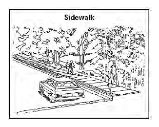
Sidewalk: A hard-surfaced pedestrian access area adjacent to or within the right-of-way of a street.
Sight distance: The length of roadway ahead visible to a driver.
Street: A dedicated and accepted public right-of-way, or a private street approved by the Jackson County Board of Commissioners, which affords the principal means of access for motor vehicles to abutting properties.

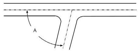
Street jog: The incidence where two streets or two portions of a single street are separated by a relatively short distance, usually at their intersection with another street (see illustration).
Traveled way: The portion of the roadway provided for the movement of vehicles, exclusive of shoulders, auxiliary lanes and bicycle lanes.
(Ord. No. 17-003, § 1, 10-2-2017)
Sec. 1602. - Street access requirements and driveways.
Sec. 1603. - Additional specifications.
Unless otherwise specially set forth in this article or the standard drawings of Jackson County adopted in article 23 of this UDC, all of the materials, methods of construction, and workmanship for the work covered in reference to street construction and storm drainage construction shall conform to the latest standard specifications of the Georgia Department of Transportation.
(Ord. No. 17-003, § 1, 10-2-2017)
Sec. 1611. - Standards generally.
Public streets contained wholly within a subdivision or land development shall be improved to the full standards contained in this article and article 23 of this UDC. See standard drawings T-1 through T-7 in article 23 of this UDC.
(Ord. No. 17-003, § 1, 10-2-2017)
Sec. 1612. - Street right-of-way.
(a)
All state or U.S. numbered highways shall meet all design requirements of and be approved by the Georgia Department of Transportation.
(b)
All other roads shall meet the minimum street right-of-way requirements of table 16-1. The public development director shall determine which street classification applies in particular instances, based on the county's adopted roadways plan.
Table 16-1
Minimum Required Street Right-of-Way
(Excludes State and U.S. Numbered Highways)
(c)
Additional right-of-way may be required to accommodate turning lanes or other improvements.
(d)
In residential subdivisions or land developments, streets that serve 100 dwelling units or more shall be improved to or exceed "minor collector" street standards, while those serving fewer than 100 dwelling units shall be improved to or exceed "local" street standards.
(e)
Subdivisions or developments that adjoin an existing street that does not meet the right-of-way width required by this development code for said street as classified, shall dedicate up to one-half of the right-of-way needed to meet the minimum right-of-way width required for the street along the entire property frontage. If any part of a subdivision or land development fronts on both sides of an existing street, all of the right-of-way needed for the existing street to meet the right-of-way standards of this development code for the street shall be dedicated along the entire property frontage.
(Ord. No. 17-003, § 1, 10-2-2017; Ord. No. 22-008, § 1, 7-18-2022)
Sec. 1613. - Planned streets.
When a future street or road, proposed in the comprehensive plan or countywide roadways plan, adjoins or traverses a subdivision or development project, the future right-of-way shall be platted as part of the subdivision or development project. No development will be allowed within the platted future right-of-way except for drives and landscaping, and the platted future right-of-way is to be treated as a lot line for the provision of all setback lines as required by this article.
(Ord. No. 17-003, § 1, 10-2-2017)
Sec. 1614. - Continuation of existing streets.
When a new street is proposed within a development or subdivision, the development or subdivision shall provide for the continuation or projection of any existing street adjoining the development or subdivision at the same or greater right-of-way and pavement width. Where, in the opinion of the public development director, it is necessary to provide for street access to adjoining property, proposed streets shall be extended by dedication of right-of-way to the boundary of such property through the development.
(Ord. No. 17-003, § 1, 10-2-2017)
Sec. 1615. - Access streets, private.
Whenever a major subdivision is proposed abutting the right-of-way of a U.S. or state highway, a private access street approximately parallel and adjacent to such right-of-way shall be required at a distance suitable for the appropriate use of land between such access street and highway right-of-way. Private access streets shall be constructed to county standard detail T-6 with regard to right-of-way, pavement width, and curb and gutter, and to county standard detail T-7 with regard to subgrade and paving details. The public development director shall also require a no-access easement of specified width and planting strip along the highway to ensure that lots fronting on said highway do not have access thereto.
(Ord. No. 17-003, § 1, 10-2-2017)
Sec. 1616. - Dead-end streets and cul-de-sacs.
(a)
Cul-de-sac required. Streets that dead-end shall terminate in a cul-de-sac meeting the requirements of this article. See also standard drawing T-22 in article 23 of this UDC. A dead-end street other than a cul-de-sac shall not be allowed except as a temporary stage of construction of a street that will be extended in a later stage of construction.
(b)
Minimum length. A cul-de-sac street shall have a minimum length of at least 125 feet.
(c)
Maximum length. The maximum length of a cul-de-sac street shall be 600 feet, unless necessitated by topographic or other conditions and approved by the public development director. If these conditions exist, the maximum length shall be 1,500 feet unless a greater length is approved as a special exception by the board of adjustment.
(d)
Residential street. Cul-de-sacs in residential subdivisions shall terminate in a circular turnaround having a minimum right-of-way of at least 100 feet in diameter (50-foot radius) and a paved turnaround with a minimum outside diameter of 80 feet (40-foot radius).
(e)
Commercial and industrial street. Cul-de-sacs in commercial and industrial subdivisions shall terminate in a circular turnaround having a minimum right-of-way of at least 120 feet in diameter (60-foot radius), and a paved turnaround with a minimum outside diameter of 100 feet (50-foot radius).
(f)
Temporary cul-de-sac. Streets that are planned to continue at some future date shall provide a temporary cul-de-sac as required by the public development director. The minimum radius for a temporary cul-de-sac shall be 40 feet. Temporary turnarounds shall consist of three inches of graded aggregate base and one inch of asphalt. A temporary cul-de-sac shall be made permanent within 12 months if the next phase is not permitted. See also standard drawing T-23 in article 23 of this UDC.
(Ord. No. 17-003, § 1, 10-2-2017)
Sec. 1617. - Alleys.
(a)
Alleys may be required at the rear of all lots used for multi-family, commercial or industrial developments. Alleys may be provided to facilitate rear-access to garages on each lot at the discretion of the subdivider/developer with approval of the public development director.
(b)
If alleys are provided, they must be paved.
(c)
If alleys are provided, they must be private and shall not be publicly dedicated.
(d)
Dead-end alleys shall be avoided were possible; but if unavoidable, they shall be provided with a turn-around having a radius of at least 40 feet, or a "T-head" turn-around approved by the public development director.
(Ord. No. 17-003, § 1, 10-2-2017)
Sec. 1618. - Street alignment and offsets/jogs.
(a)
Streets shall be aligned to join with planned or existing streets.
(b)
No new street that intersects a state or U.S. numbered highway shall be approved unless there is maintained a separation of at least 800 feet from any other street.
(c)
The Georgia Department of Transportation may require a greater separation between streets intersecting a state or U.S. numbered highway.
(d)
Other, local, adjoining street intersections shall be spaced at least 250 feet apart measured from edge of right-of-way to edge of opposing right-of-way.
(Ord. No. 17-003, § 1, 10-2-2017)
Sec. 1619. - Street intersection angles.
All streets shall intersect at no less than 75 degrees, and as near a right angle as possible. The angle of intersection is to be measured at the intersection of the street centerlines.
Such intersecting streets shall provide an uninterrupted line of sight from the center point of the intersection for not less than the minimum sight distance required in accordance with this UDC.
(Ord. No. 17-003, § 1, 10-2-2017)
Sec. 1620. - Street intersection curb radii.
Turning radii for street intersections shall be provided as follows, based on the highest street classification involved in the intersection as listed below. Where the angle of street intersection is less than 90 degrees, a longer radius may be required.
(a)
Arterial: 50-foot radius.
(b)
Major collector: 35-foot radius.
(c)
Minor collector: 25-foot radius.
(d)
Local street: 20-foot radius.
(Ord. No. 17-003, § 1, 10-2-2017)
Sec. 1621. - Street grades.
(a)
Minimum grades. All streets shall have a minimum grade of 0.5 percent. Minimum grade on cul-de-sacs shall be one percent. See also standard drawing T-11 in article 23 of this UDC.
(b)
Maximum grades and minimum design speeds. Maximum grades and minimum design speeds for proposed streets by street type shall be as required in table 16-2. Design exceptions must be justified and approved by the public development director.
Table 16-2
Maximum Grades and Minimum Design Speeds
(Ord. No. 17-003, § 1, 10-2-2017)
Sec. 1622. - Horizontal alignment of streets.
Where a deflection angle of more than five degrees in the alignment of a street occurs, the radius of curvature of the center line of said street shall be not less than as shown on table 16-3.
(Ord. No. 17-003, § 1, 10-2-2017)
Table 16-3
Horizontal Alignment of Streets
Curved streets shall have a minimum tangent of 100 feet at intersections as measured from the centerline of cross streets. A tangent of a least 200 feet in length shall be introduced between reverse curves on collector streets, and 100 feet on local streets.
(Ord. No. 17-003, § 1, 10-2-2017)
Sec. 1623. - Minimum sight distance.
(a)
Sight distance requirements at intersections and driveways shall be as required in table 16-4. The design speed for sight distance requirements at entrance intersections shall be the existing posted speed limit. Distances shall be measured from a point on the centerline of the entering road or driveway ten feet back from the edge of the nearest traffic way in the abutting street, and extending in both directions along the abutting street. Minimum sight distances shall be measured from the driver's eyes, which are assumed to be 3.75 feet in height above the pavement surface, to an object six inches high on the pavement in the center of every on-coming travel lane. The sight distance shall be clear along its entire minimum length and unimpaired by intervening changes in street grade, horizontal alignment or obstructions. Examples of obstructions are vegetation, ground cover, signs, existing topography, etc.
Table 16-4
Minimum Sight Distance Requirements
*One hundred twenty-five-foot street spacing for internal residential streets only. Any external non-residential street spacing shall be a minimum of 150 feet.
(b)
Minimum sight distance requirements of this section may be designed in accordance with AASHTO's Geometric Design of Highways and Streets if such standards conflict with the requirements of this section.
(c)
See also standard drawings T-32 and T-33 in article 23 of this UDC.
(Ord. No. 17-003, § 1, 10-2-2017)
Sec. 1624. - Pavement width.
Roadways shall be constructed and paved with top courses meeting the following standards. The minimum pavement width, measured from edge of pavement to edge of pavement, (or from the inner edge of curb where curbing exists) shall be as required for the street type in table 16-5. See also standard drawings T-1 through T-7 as appropriate in article 23 of this UDC.
(Ord. No. 17-003, § 1, 10-2-2017)
Table 16-5
Street Base and Pavement Width
GAB = graded aggregate base.
(Ord. No. 17-003, § 1, 10-2-2017)
Sec. 1625. - Deceleration and turning lanes.
(a)
When required. See section 612 of this UDC for instances when development requires that turning lanes and deceleration lanes be installed by the developer. In addition, a deceleration lane shall be required at each street entrance to a multi-family development of 25 or more units and any commercial or industrial development. At the discretion of the public development director and county road superintendent, a deceleration lane shall be required at each street entrance to a single family residential subdivision of 25 lots or more.
(b)
Length. See standard drawing T-12 in article 23 of this UDC for deceleration lanes and standard drawings T-13 and T-14 for left-turn lanes. Generally, deceleration lanes and turn lanes shall be a minimum length of 150 feet, with an additional 50-foot taper length, and a pavement width of 12 feet (exclusive of curb and gutter). Deceleration lanes and tapers may be required to be of greater length, based on the design speed of the road.
(c)
Right-of-way. Additional right-of-way to accommodate the deceleration lane or turn lane and a ten-foot shoulder shall be dedicated by the developer to Jackson County.
(d)
Drainage. Associated drainage improvements as deemed necessary by the county by the construction of the deceleration or turn lane shall also be required. The developer will pay the cost of any cross-drain pipe relocations and catch basins that must be constructed along an existing county road as a result of installing a required deceleration or turning lane.
(e)
Utilities. Utilities shall be relocated at the developer's expense outside of a deceleration or turning lane. Waterlines can remain beneath the additional lanes.
(Ord. No. 17-003, § 1, 10-2-2017)
Sec. 1626. - Street base.
(a)
Graded aggregate base course. The base course shall consist of mineral aggregate and may be a combination of natural deposit or a blend of the materials specified. All materials are subject to approval by the public development director. If a blend of materials is used, it shall be blended through a base plant that meets the latest specifications of the Georgia Department of Transportation Specification 815.
(b)
Thickness of material. Street base material shall conform to the thickness as required for the street type on table 16-5.
(c)
Extension. For streets without curbs, the base shall extend at least one foot beyond the edge of payment.
(d)
Replacement of unsuitable material. Wherever unsuitable material is found in the subgrade, the unsuitable material shall be replaced with graded aggregate stone.
(e)
Standard detail reference. See also standard details T-1 through T-7 as applicable.
(Ord. No. 17-003, § 1, 10-2-2017)
Sec. 1627. - Pavement topping.
(a)
Prime. After the base has been placed, mixed, compacted, shaped, inspected and accepted, it shall be primed with suitable asphaltic materials as specified in Department of Transportation Specification 412.
(b)
Roadway binder. After the prime has been inspected and accepted, the roadway or street shall be surfaced with type "B" binder as required for the street type on table 16-5.
(c)
Tack coat. Tack coat shall be applied on a prepared road surface according to the requirements of Georgia Department of Transportation Specification 413.
(d)
Final topping. Final topping shall consist of a course of type "E" asphaltic cement as required for the street type as required by table 16-5.
(e)
Standard detail reference. See also standard details T-1 through T-7 as applicable.
(Ord. No. 17-003, § 1, 10-2-2017)
Sec. 1628. - Testing requirements for street base and paving.
(a)
Tests shall be conducted of street base and paving as per table 16-6.
Table 16-6
Testing Requirements and Standards
(b)
When testing is required, it is the responsibility of the developer to insure that all required tests are made and reported to the public development department for review and approval by the county roads superintendent. The cost of all testing and quality control shall be performed at the expense of the developer by qualified testing laboratories.
(Ord. No. 17-003, § 1, 10-2-2017)
Sec. 1629. - Curb and gutter—Required.
Curb and gutter are required along:
(a)
All new commercial and industrial streets;
(b)
All new residential subdivision streets except for those serving lots with a minimum lot area of one acre and a minimum lot width of 150 feet;
(c)
Existing county roads that abut a subdivision where curb and gutter are required, or abut a multi-family or nonresidential development; and
(d)
New construction on existing county streets and roads, including deceleration lanes and travel lane widenings.
(Ord. No. 17-003, § 1, 10-2-2017)
Sec. 1630. - Curb and gutter—Detail.
(a)
Local residential street curbs shall be Portland cement concrete, six-inch x 24-inch x ten-inch vertical or roll back type, with a minimum strength of 3,000 psi at 28 days. For vertical curbing, see standard drawing T-24 in article 23 of this UDC.
(b)
Curbs along collectors and local commercial or industrial street curbs shall be Portland cement concrete, six-inch x 24-inch x 12-inch vertical type only, with a minimum strength of 3,000 psi at 28 days.
(c)
All curbing shall be backfilled and grassed. The curb and gutter shall be constructed so as to present a smooth, even line both horizontally and vertically. There shall be no areas of ponding.
(d)
A valley gutter may be used across a driveway at its intersection with a street. However, valley gutters shall not be allowed across streets at street intersections unless specifically approved by the public development director.
(e)
See also standard drawing T-08 in article 23 of this UDC for utility placement with curb and gutter.
(Ord. No. 17-003, § 1, 10-2-2017)
Sec. 1631. - Slopes and shoulder improvements.
(a)
On streets with curb and gutter, the shoulders shall slope one-quarter-inch to the foot toward the roadway for at least seven feet from back of curb, and no more than one-half inch to the foot for the remainder of the right-of way width.
(b)
On streets with swale ditch drainage, the shoulders shall slope three-quarter-inch to the foot away from the roadway for at least five feet to the drainage channel. The maximum slope for the drainage channel shall be two feet of run for each one foot of fall, with a minimum two-foot wide channel at the bottom of the swale.
(c)
Immediately after grading and filling and re-spreading of topsoil, all areas of disturbed soil shall be fertilized and seeded (or in steep areas sodded or otherwise appropriately treated) with suitable vegetative cover to retard erosion.
(d)
When all construction is completed, all slopes and shoulders shall be cleared of all rubbish and shall have a stand of grass to prevent undue erosion, either by sprigging or seeding.
(Ord. No. 17-003, § 1, 10-2-2017)
Sec. 1632. - Street names and street name signs.
(a)
Street names are subject to the approval of the Jackson County Emergency Services Department and the public development director. See also standard drawing T-26 in article 23 of this UDC.
(b)
Proposed public or private streets, which are extensions of, or in alignment with, existing or other proposed streets shall have the same name.
(c)
Street names shall not duplicate or be phonetically similar to existing street names.
(d)
Street name signs of a type approved by the county are to be placed at all intersections. Unless otherwise adopted by county roads superintendent, street signs shall be constructed of aluminum sheets with reflective backgrounds. Information on the street name signs shall be readable from both sides of the sign. Signs shall be installed on a steel post. The vertical distance from the road elevation to the bottom of the sign face shall be seven feet with a minimum burial depth of three feet.
(e)
Street name signs shall be installed by the county at the developer's expense.
(Ord. No. 17-003, § 1, 10-2-2017)
Sec. 1633. - Traffic signs and striping.
(a)
Traffic control signs shall conform to the Manual on Uniform Traffic Control Devices, latest edition. The county shall install required traffic control signs at the subdivider's or developer's expense.
(b)
All newly constructed streets having four or more lanes (including auxiliary lanes) and existing streets being widened with one or more additional lanes shall be striped or the payment of said striping costs shall be required from the developer by Jackson County prior to the approval of development conformance for the project. Striping shall be accomplished with paint meeting Georgia DOT standards conforming to the Manual on Uniform Traffic Control Devices.
(Ord. No. 17-003, § 1, 10-2-2017)
Sec. 1634. - Street lighting.
(a)
Required. Street lighting shall be required on all new public and private streets as follows:
1.
At any new street intersection, regardless of use;
2.
New residential subdivision streets serving lots less than one acre in area and less than a minimum lot width of 150 feet; for streets serving lots with a minimum lot area of one acre and a minimum lot width of 150 feet, street lighting is not required except at new street intersections; and
3.
New commercial subdivision streets. Streets serving exclusively industrial uses shall not require street lighting except at street intersections.
(b)
Standard. Street lighting when required shall be installed according to design standards of the power company servicing the subdivision or development and section 34-132 of the Jackson County Code of Ordinances, as applicable and provided further, the minimum height of a street light shall be 25 feet above the road surface.
(c)
Plan approval. The subdivider or developer shall submit a street light layout prepared by the utility company which will provide the lighting service showing the exact location of street lights within the subdivision. The lighting layout must be approved by the county road superintendent and the public development director.
(d)
Operation cost responsibility. The Jackson County Board of Commissioners will not assume responsibility for the operational costs of streetlights required by this section even though said street lights may be within a dedicated public right-of-way, however, when street lights are part of a special tax district specified in section 34-132 of the Jackson County Unified Development Code, the responsibility for paying the utility bill for streetlights shall be transferred to Jackson County Government. Subsequently, payment will be recovered through property taxes from properties located within the special tax district.
(Ord. No. 17-003, § 1, 10-2-2017; Ord. No. 24-005, § 2, 8-19-2024)
Sec. 1635. - Traffic calming devices.
All traffic calming devices, shall be reviewed and approved by the county road superintendent and the public development director.
(Ord. No. 17-003, § 1, 10-2-2017)
Sec. 1636. - Private streets.
(a)
Private streets, if approved by the county, shall meet all requirements and standards that apply to public streets as specified in this article and UDC.
(b)
Any gate placed across a private street that limits access to a subdivision or development shall provide for unimpeded access by emergency vehicles, governmental vehicles on official business, and public and private delivery services including the U.S. Postal Service. Accessibility to such gated communities shall comply with all standards and requirements of the county for access activation, and shall be of breakaway or other construction acceptable to the county.
(c)
See also sections 1566 and 1567 of this UDC for additional requirements related to private streets.
(Ord. No. 17-003, § 1, 10-2-2017)
Sec. 1651. - Sidewalks required.
Sidewalks are required to be installed by the developer at the time of development as follows:
(a)
On both sides of all new commercial and industrial streets.
(b)
On both sides of streets serving residential subdivisions with 25 or more lots, except for those subdivisions with a minimum lot size of one acre and a minimum lot width of 150 feet.
(c)
Along the side of existing county streets and roads that abut a subdivision where sidewalks are required, or abut a multi-family or nonresidential development.
(Ord. No. 17-003, § 1, 10-2-2017)
Sec. 1652. - Sidewalk placement.
(a)
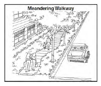
Sidewalks shall be included within the dedicated nonpavement right-of-way of roads and shall parallel the street pavement as much as possible; provided, however, the public development director may permit sidewalks to be designed and constructed so that they meander around permanent obstructions or deviate from a linear pattern for design purposes.
(b)
A strip of grassed or landscaped areas at least two feet wide shall separate all sidewalks from adjacent curbs in residential areas.
(Ord. No. 17-003, § 1, 10-2-2017)
Sec. 1653. - Sidewalk construction.
(a)
See standard drawing T-25 in article 23 of this UDC.
(b)
Sidewalks must comply with all requirements of the federal Americans with Disabilities Act. See also standard drawing T-29, T-29B, and T-29C in article 23 of this UDC.
(c)
Concrete sidewalks shall be a minimum of five feet wide and four inches thick.
(d)
Concrete shall be 3,000 psi at 28 days' strength.
(e)
Sidewalks shall be backfilled and landscaped.
(Ord. No. 17-003, § 1, 10-2-2017)