
Jackson County Unincorporated
City Zoning Code
City Zoning Code
ARTICLE 15
- SUBDIVISION OF LAND
Sec. 1501. - Purposes.
This article is adopted for the following purposes, among others:
(a)
To assure equitable handling of all subdivision plats by providing uniform procedures and standards for the subdivider;
(b)
To assure, in general, the wise development of new land areas, in harmony with the comprehensive plan of the county;
(c)
To assure the accurate description of property, the identification of property boundaries with monuments, and the proper recording of property descriptions in public records;
(d)
To help eliminate the costly maintenance problems which occur when streets and lots are laid out without proper consideration given to various public purposes;
(e)
To protect lot purchasers who generally lack the specialized knowledge to evaluate subdivision improvements and design; and
(f)
To implement the Georgia Plat and Condominium Plan Recording Act of 2017 and other applicable state laws.
(Ord. No. 17-003, § 1, 10-2-2017)
Sec. 1502. - Authority of director of public development.
(a)
In accordance with the provisions of this article, the director of public development shall have final authority with regard to the review and approval, conditional approval, or disapproval of preliminary plats, final plats, lot combination plats, boundary line adjustments, dedication plats and condominium plans; provided, however, the director does not have authority to accept any public improvements on behalf of the Jackson County Board of Commissioners. Public streets shall only be accepted by the Jackson County Board of Commissioners, following procedures for public dedications specified in this article.
(b)
The director of public development shall not sign and approve any final or other plat required by this article, nor shall any plat be authorized for recording, unless the plat meets the minimum requirements of this article and any other applicable provision of this UDC.
(Ord. No. 17-003, § 1, 10-2-2017)
Sec. 1503. - Definitions.
Block: An area of land that is entirely surrounded by streets, public lands, railroad rights-of-way, watercourses, or other well defined and fixed boundaries.
Condominium plan: A drawing that is required to be recorded prior to the first conveyance of a condominium unit pursuant to O.C.G.A. § 44-3-83(b), including, but not limited to, a condominium floor plan, condominium plot plan, or condominium site plan.
Cul-de-sac: A dead-end street of limited length having a primary function of serving adjoining land, and constructed with a turnaround at its end.
Dedication plat: A plat drawn specifically for the purpose of dedicating public right-of-way or land for public use, drawn to meet final plat specifications and following procedures for final plat approval of this article.
Easement: A grant of one or more of the property rights by the property owner to and/or for use by the public, a corporation, or another person or entity.
Final plat: The final drawing of a subdivision and, as applicable, dedication, prepared for filing for record with the Clerk of Superior Court of Jackson County, and containing all elements and requirements set forth in this article.
Homeowners association: An organization formed for the maintenance and operation of the common areas of a subdivision or development, where membership in the association is automatic with the purchase of a dwelling unit or lot within the development, with the ability to legally assess each owner of a dwelling unit or lot and which has authority to place a lien against all dwelling units and lots within the subdivision or development.
Lot: A parcel or tract of land held in single ownership.
Lot, corner: A lot abutting upon two or more streets at their intersection.
Lot depth: The average horizontal distance between the front and rear lot lines.
Lot, double frontage: A lot other than a corner lot that has frontage upon two or more streets that do not intersect at a point abutting the property.
Lot, flag: A tract or lot of land of uneven dimensions in which the portion fronting on a street is less than the required minimum width required for construction of a building or structure on that lot.
Major subdivision: The division of a tract of land into any number of lots, which requires the construction of a new street or the widening of an existing roadway, the provision of stormwater drainage facilities (other than driveway culverts), or the construction or improvement of public utilities; or the division of land into more than five lots, regardless of whether public improvements are involved.
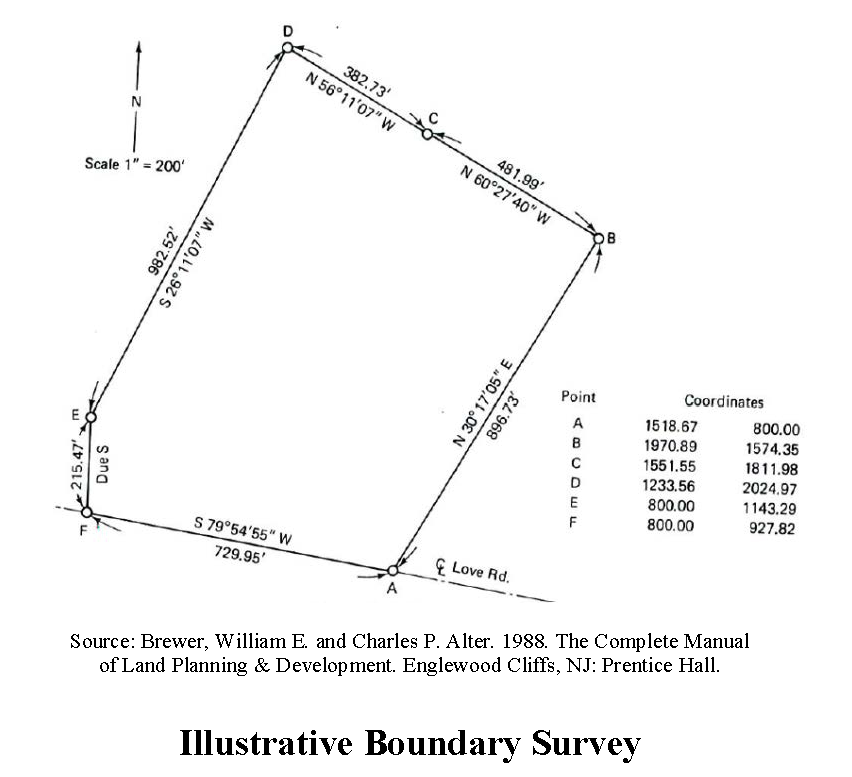
Metes and bounds: A system of describing and identifying land by a series of lines around the perimeter of an area; "metes" means bearings and distances and "bounds" refers to physical monuments.
Minor subdivision: The division of a tract of land into five or less lots which does not require public improvements, as defined.
Preliminary plat: A professional drawing which shows the proposed layout of a subdivision in sufficient detail to indicate its general design. A preliminary plat is prepared by a professional engineer, a registered land surveyor, a landscape architect, a land planner, or any other person professionally familiar with land development and project construction activities. A preliminary plat is not a construction document.
Professional engineer: An engineer duly registered or otherwise authorized by the State of Georgia to practice in the field of civil engineering.
Protective covenants: Contracts made between private parties as to the manner in which land may be used, with the view toward protecting and preserving the physical and economic integrity of any given area.
Public improvement: The construction, enlargement, extension or other construction of a facility intended for dedication to the county or a public utility provider or to a facility already owned by the county, including but not limited to a street, curb and gutter, sidewalk, cross drain, catch basin, other roadway appurtenance, domestic water supply system main, fire hydrant, valve or other water system appurtenance, or sanitary sewerage main or outfall, lift station, force main, manhole or other appurtenance. Utility supply lines to a building are not considered public improvements. Construction of a driveway apron connection shall not be considered a public improvement for purposes of triggering preliminary plat approval.
Registered land surveyor: A land surveyor licensed and registered to perform the duties of a registered land surveyor (R.L.S.) by the State of Georgia.
Retracement: A survey, not required to be reviewed and approved by the local jurisdiction prior to filing or recording in the clerk's office, but drawn to specifications required by this article.
Septic tank: An approved watertight tank designed or used to receive sewage from a building sewer and to affect separation and organic decomposition of sewerage solids, and discharging sewage effluent to an absorption field or other management system.
Subdivider: Any person who undertakes the subdivision of land, and any person having such a proprietary interest in land to be subdivided as will authorize the maintenance of proceedings to subdivide such land under this UDC, or the authorized agent of such person.
Subdivision: The division of a property or tract of land into two or more tracts or lots; or a land development project in which two or more lots are created, along with the streets and utilities needed to support construction of buildings on the lots. The word "subdivision" includes re-subdivision and, when appropriate to the context, relates either to the process of subdividing or to the actual land or area which is subdivided.
(Ord. No. 17-003, § 1, 10-2-2017)
Sec. 1504. - Exemptions from plat approval.
The following types of land subdivisions, transfers, and sales are specifically exempted from the plat approval requirements of this article; provided, however, that such exemptions shall not apply to land development requirements and improvement requirements of this article or compliance with other applicable requirements of this UDC:
(a)
Retracement surveys and easement surveys, as specifically authorized in this article;
(b)
The creation and sale of cemetery plots;
(c)
The sale of lots consistent with previously approved and recorded plats or deeds;
(d)
The creation of leaseholds for space within a multiple-occupancy building or the division of property into leaseholds (but not for sale) for commercial, industrial, or institutional use;
(e)
The creation of leaseholds (but not for sale) for the agricultural use of property where the use does not involve the construction of a building to be used as a residence or for other purposes not directly related to agricultural use of the land or crops or livestock raised thereon.
(f)
Any division of land to heirs through a judicial estate proceeding, or any division of land pursuant to a judicial partition, or any division of land occurring from the foreclosure of a deed of trust; provided, however, that such exemption shall not require the public development department to issue permits if the resulting lots or parcels fail to meet any applicable zoning provisions regarding lot size, lot width, or other dimensional requirements.
(Ord. No. 17-003, § 1, 10-2-2017)
Sec. 1511. - Land is one lot until subdivided.
Until property proposed for subdivision has received final plat approval and been properly recorded, the land involving the subdivision shall be considered as one lot, or as otherwise legally recorded.
(Ord. No. 17-003, § 1, 10-2-2017)
Sec. 1512. - Subdivision of land.
(a)
No person shall subdivide land except in accordance with this article and this UDC.
(b)
It shall be unlawful to sell or transfer title to another person any lot or tract or portion thereof of land that has not been established as a lot of record, except in compliance with this article. Unless the lot to be sold or transferred is a lot of record, final plat approval by the county in accordance with this article shall be required. This section shall not be interpreted as limiting the sale or transfer of lots consistent with previously lawfully approved recorded plats or deeds.
(c)
It shall be unlawful for any person, firm, corporation, owner, agent or subdivider, by deed or plat, to sell, transfer, agree to sell, offer at public auction, negotiate to sell or subdivide any land until a preliminary plat, if required, and final plat have been approved by the public development department and final plat recorded in accordance with this article. Said restriction applies to lands subdivided for non-residential as well as residential uses. The description by metes and bounds in the instrument of transfer or other document used in the process of selling or transfer shall not exempt the transaction from compliance with this article or from the penalties established for violations of this UDC.
(d)
The county through its attorney or other designated official may enjoin such transfer of, sale, or agreement by appropriate action.
(Ord. No. 17-003, § 1, 10-2-2017)
Sec. 1513. - Review of subdivisions along state routes.
(a)
No subdivision plat containing land which abuts a state route shall be approved until such plat has been submitted for review and comment by the Georgia Department of Transportation, in accordance with the provisions of O.C.G.A. § 32-6-151.
(b)
When the county receives such a plat, it shall submit two copies of the proposed subdivision plat to the Georgia Department of Transportation if such proposed subdivision includes or abuts on any part of the state highway system. The Georgia Department of Transportation, within 30 days of receipt of the plat, shall recommend approval and note its recommendation on the copy to be returned to the public development director or recommend rejection. Failure of the Georgia Department of Transportation to act within this 30-day period shall constitute approval. If the plat is recommended for rejection, the reasons for rejection and requirements for approval shall be given to the public development department in writing; but such recommendation shall be advisory only and shall not be binding.
(Ord. No. 17-003, § 1, 10-2-2017)
Sec. 1514. - Lots must comply with UDC requirements.
No person shall subdivide land, and the public development director shall not approve any subdivision of land, unless the lots created pursuant to said subdivision meet or exceed all applicable requirements of the zoning district in which it is located, overlay district if applicable, environmental overlay district if applicable and any other applicable requirements of this UDC, and as may be amended from time to time. For minimum lot frontage, minimum lot width and minimum lot size requirements by zoning district, see table 2-2 of this UDC.
(Ord. No. 17-003, § 1, 10-2-2017)
Sec. 1515. - Improvements required for final platting.
No final subdivision plat involving a public dedication of land or public improvement of streets or public utilities shall be approved by the public development department or accepted for recordation by the Clerk of Superior Court of Jackson County until all improvements, if required by this article or UDC generally, have been constructed or installed in a satisfactory manner and approved by the public development department and public utility provider as applicable.
(Ord. No. 17-003, § 1, 10-2-2017)
Sec. 1516. - Creation of homeowner's association.
(a)
Required. For any major subdivision involving common areas, open spaces, and/or a stormwater detention facility on a separate tract within the subdivision, a homeowner's or property owner's association shall be required to be created which shall be responsible for the ownership and maintenance of common areas, open spaces and/or stormwater detention facilities within the subdivision. The homeowner's or property owner's association must be maintained as the responsible owner of such facilities and lands and shall not be dissolved unless another ownership entity is accepted by the Jackson County Board of Commissioners.
(b)
Mandatory membership. Membership in the homeowner's association must be mandatory for each property in the development.
(c)
Bylaws and covenants. Such association must also include homeowner's or property owner's declaration and bylaws, including covenants, conditions and regulations applicable to each property in the development.
(d)
Approval and recording. The instruments of such creation and financial endowment shall be submitted to the public development department for review and approval; covenants are also subject to approval by the county attorney, and such approval shall be obtained prior to recording. Said instruments shall also be recorded at the time of final plat recording with cross-references to recording information on both the instruments and the final plat. A copy of the recorded instruments shall be filed with the public development department following recording.
(e)
Reserve account. At the time control of the association is passed from the declarant to the property owners, the association shall have a reserve account of not less than $125.00 per occupied residence for residential associations or for nonresidential subdivisions an amount approved by the public development director. There shall be no debt incurred to the association.
(f)
Enforcement. The declaration and bylaws shall be enforced by an association management company, which shall have the power to compel the payment of membership dues and assessments.
(g)
Condominium association. For condominium projects, incorporation of a condominium association consistent with state law will serve in lieu of the requirements of this section.
(Ord. No. 17-003, § 1, 10-2-2017)
Sec. 1517. - Easements.
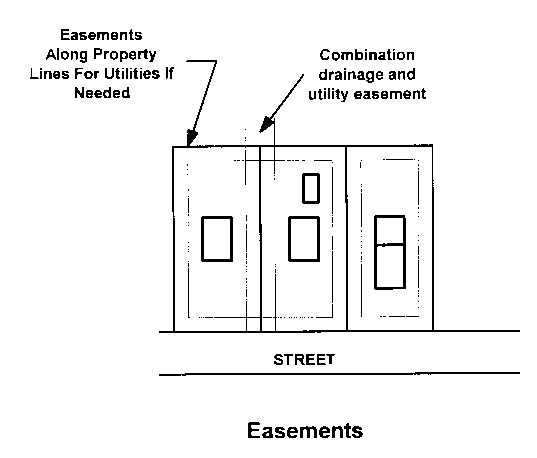
(a)
Easements for drainage or public utilities may be required in connection with any major or minor subdivision as determined by the public development department in conjunction with utility providers. A drainage easement is required and shall be provided along any manmade drainage channel or drainage pipe located outside a street right-of-way. When required, easements shall be shown on the final plat.
(b)
The minimum width of any drainage, water, or sanitary sewer easement shall be 20 feet. Easements for water, sanitary sewers and/or drainage purposes may be combined, but must be a minimum of 30 feet if in combination. Pedestrian easements, if required by the public development department, shall be at least ten feet wide.
(Ord. No. 17-003, § 1, 10-2-2017)
Sec. 1518. - Retracement surveys.
Pursuant to O.C.G.A. § 44-2-26, the owner of real property, or of any interest therein or any holder of a lien thereon may file a plat of the property in the office of the clerk of superior court of the county in which the property or any part thereof is located. Said plat shall be considered a retracement survey, provided that it contains the surveyor certification box for retracement surveys as required by this article (see sections 1562 and 1563). Such retracement survey shall not require local approval and shall be entitled to be filed and recorded.
(Ord. No. 17-003, § 1, 10-2-2017)
Sec. 1519. - Surveyor certification box for retracement surveys.
(a)
Each plat of a retracement survey shall have depicted thereon a box which contains the following applicable certifications of the land surveyor:
"This plat is a retracement of an existing parcel or parcels of land and does not subdivide or create a new parcel or make any changes to any real property boundaries. The recording information of the documents, maps, plats, or other instruments which created the parcel or parcels are stated hereon. RECORDATION OF THIS PLAT DOES NOT IMPLY APPROVAL OF ANY LOCAL JURISDICTION, AVAILABILITY OF PERMITS, COMPLIANCE WITH LOCAL REGULATIONS OR REQUIREMENTS, OR SUITABILITY FOR ANY USE OR PURPOSE OF THE LAND. Furthermore, the undersigned land surveyor certifies that this plat complies with the minimum technical standards for property surveys in Georgia as set forth in the rules and regulations of the Georgia Board of Registration for Professional Engineers and Land Surveyors and as set forth in O.C.G.A. Section 15-6-67."
(b)
The land surveyor shall sign on a line immediately beneath the certification on the plat. At the discretion of the land surveyor and in conformity with local regulations, the surveyor may electronically sign the certification using a facsimile signature. The facsimile signature may be a reproduction of an original signature or an electronically created signature. If the land surveyor elects to use a facsimile signature, the surveyor must maintain full control over the application and use of such signature.
(c)
In the case of a plat that is a retracement survey, the land surveyor shall state clearly the recording information of any document, map, plat, or other instrument which created any of the parcels depicted. The depiction of gores, overlaps, or other parcel delineation as may be necessary to remedy or address title issues or deficiencies shall be allowed as part of the retracement function.
(d)
Plats bearing the certification required for retracement surveys shall be entitled to recordation without further review or local approval.
(Ord. No. 17-003, § 1, 10-2-2017)
Sec. 1520. - Easement surveys.
Plats that depict existing or proposed easements, including for any purpose including utilities, access, no access, or for conservation purposes, may be recorded using the certification for retracement surveys, provided that there are no changes to any real property boundaries, and provided that the plat includes information required by sections 1562 and 1563 of this article. Plats bearing the certification required for retracement surveys shall be entitled to recordation without further review or local approval.
(Ord. No. 17-003, § 1, 10-2-2017)
Sec. 1531. - Preliminary plat—When required.
Any subdivision involving the dedication of a public street or public land, any subdivision involving a new private street, and any subdivision requiring a public improvement as defined, shall require the submission and approval by the county of a preliminary plat.
(Ord. No. 17-003, § 1, 10-2-2017)
Sec. 1532. - Relationship of preliminary plat to development permit.
(a)
Preliminary plat approval requests shall be processed in conjunction with an application for development permit. No separate preliminary plat application shall be required to be submitted or approved; provided, however, that the application for development permit shall include information specified in this division.
(b)
A development permit per article 8 of this UDC shall be required prior to initiation of any land disturbing or construction activities on the lands proposed for subdivision.
(c)
Preliminary plat approval shall be valid so long as the development permit for the proposed subdivision remains valid. If the development permit for the proposed subdivision is invalidated or expires, so too will preliminary plat approval.
(Ord. No. 17-003, § 1, 10-2-2017)
Sec. 1533. - Preliminary plat specifications.
The following specifications are required for a preliminary plat, which shall be submitted as part of the application for development permit:
(a)
Proposed name of subdivision. The proposed name of the subdivision shall not duplicate or too closely approximate, phonetically, the name of any other subdivision in the city or county. If shown to the contrary, the public development department may refuse to accept such subdivision name.
(b)
Plat scale and sheet size. The preliminary plat shall be clearly and legibly drawn at a scale of 100 feet or less to one inch. The recommended maximum dimensions of the sheet size is 36 inches by 48 inches and the minimum dimensions of 17 inches by 22 inches; however, the public development department may approve other sheet sizes and scales as appropriate.
(c)
Owner and professional contact information. Name, mailing address, telephone and fax numbers and e-mail address of the property owner and the professional preparing the preliminary plat.
(d)
Miscellaneous. Date of boundary survey, north point and graphic scale, source of data, date of plan drawing, and, if any, revision dates.
(e)
Location and tract boundaries. Location (including militia district) and size of the property in acres (or in square feet if less than an acre), and the external boundaries of the tract to be subdivided or developed shown by bearings and distances. The preliminary plat must reference and be based on a boundary survey of the exterior boundaries of the proposed subdivision, prepared by a registered land surveyor.
(f)
Vicinity map. A location map of the property in relation to the surrounding area with regard to well-known landmarks such as arterial streets, railroads, and major water courses.
(g)
Abutting property information. Names of adjoining property owners per recorded deeds, zoning district of all adjoining properties, and if applicable overlay district designations of all adjoining properties.
(h)
Prior subdivision. Name of former approved subdivision, if any, for all of the land in the preliminary plat that has been previously subdivided, showing boundaries of same.
(i)
Zoning. Zoning district boundaries and zoning designation(s) of the subject property and, if applicable, overlay district and environmental overly district boundaries.
(j)
Application number and conditions. Rezoning, special use, and variance application number, date of approval, and conditions of approval, if applicable.
(k)
Natural features and flood plains. Natural features within the property, including topographic contours at no less than five-foot intervals, drainage channels, bodies of water, wetlands, streams with required buffer designated, wooded areas and other significant natural features such as groundwater recharge areas and rock outcroppings. On all water courses entering or leaving the property, the direction of flow shall be indicated. The 100-year flood plain, if any, shall be delineated.
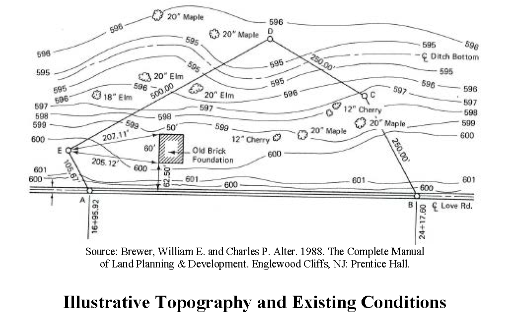
(l)
Streets, easements, political boundaries and built features. Man-made features within and adjacent to the property, including street right-of-way and pavement widths, names of existing streets, all easements, city and county political boundary lines, and other significant information such as location and dimensions of bridges, existing buildings to remain, and other features.
(m)
Subdivision block and lot layout. The proposed subdivision layout including lot lines and street right-of-way lines, with proposed street names or letter designations and right-of-way widths, along with the front building setback line and the approximate dimensions of the length and width of each lot. The total number of lots in the subdivision and the total acreage in the tract to be subdivided shall be indicated. Lots shall be numbered consecutively in a clockwise fashion, and the approximate land area of each lot shall be indicated for each lot. The proposed phasing of the subdivision shall be indicated, if it is proposed to be platted in phases.
(n)
Water and sewage disposal. A statement as to the source of the domestic water supply and provisions for sanitary sewage disposal. For those properties that will not be served by a public sanitary sewerage system, location and results of soil tests or percolation tests as required and approved by the Jackson County Environmental Health Department.
(o)
Stormwater management. The approximate location of proposed storm water detention facilities. Compliance with stormwater management requirements of this UDC will be required for the issuance of a development permit.
(p)
Public land reservations. In addition to public streets, the preliminary plat shall indicate land if any to be dedicated for public use.
(q)
Additional information. Additional information as may be required by the public development director to ensure compliance with this article and this UDC.
(r)
Approval. Approval of a development permit for the proposed subdivision shall constitute approval of the preliminary plat.
(Ord. No. 17-003, § 1, 10-2-2017)
Sec. 1541. - Suitability of land.
Land physically unsuitable for subdivision because of flooding, poor drainage, steep slopes, rock formations or other such features that may endanger health, life or property, aggravate erosion, increase flood hazard, or necessitate excessive expenditures of public funds for supply and maintenance of services shall not be approved for subdivision or development unless adequate methods are formulated by the subdivider for solving the problems.
(Ord. No. 17-003, § 1, 10-2-2017)
Sec. 1542. - Conformance with comprehensive plan and other plans.
(a)
All proposed subdivisions shall conform to the comprehensive plan and development policies in effect at the time of submission to the public development department. All highways, streets and other improvements recommended in the county roadways plan shall be platted by the developer in the location and to the dimension indicated in the county roadways plan.
(b)
When features of other plans adopted by the Jackson County Board of Commissioners (such as schools or other public-building sites, parks or other land for public uses) are located in whole or in part in a subdivision, such features shall be either dedicated or reserved by the subdivider for acquisition within a reasonable time by the appropriate public agency.
(Ord. No. 17-003, § 1, 10-2-2017)
Sec. 1543. - Block length.
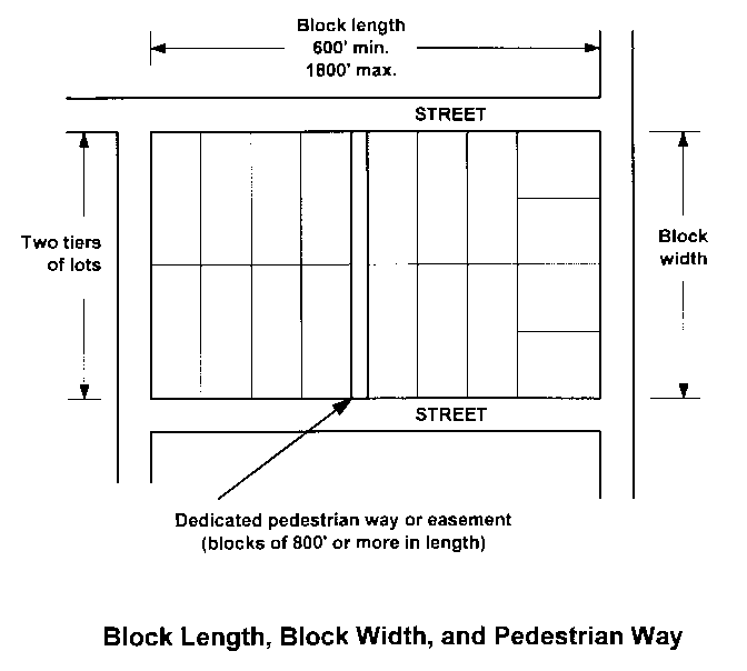
Intersecting streets shall be provided at such intervals so as to provide adequate cross traffic and connectivity. Blocks in residential subdivisions should not exceed 1,800 feet nor be less than 600 feet in length, except where topography or other conditions justify a departure from these standards. In blocks longer than 800 feet, pedestrian ways and/or easements through the block shall be required near the center of blocks.
(Ord. No. 17-003, § 1, 10-2-2017)
Sec. 1544. - Block width.
(a)
The width of a block shall be sufficient to allow two tiers of lots of appropriate depth, except where reverse frontage lots on arterial streets are provided, or when prevented by topographic conditions or size of the property, or for lots along the periphery of the subdivision, in which case the public development department may approve a single row of lots.
(b)
Blocks intended for business or industrial use shall be of such width as to be considered most suitable for their respective use, including adequate space for off-street parking, deliveries, and service.
(Ord. No. 17-003, § 1, 10-2-2017)
Sec. 1545. - Lot depth.
The depth of lots intended for detached, single-family residential shall not be greater than four times the width of the lot at the regulatory building line, unless unusual circumstances make these limitations not practicable. Lots intended for other uses should observe this maximum lot depths standard where practicable.
(Ord. No. 17-003, § 1, 10-2-2017)
Sec. 1546. - Adequate building site.
Each lot shall contain an adequate building site not subject to flooding and outside the limits of any existing easements, required building setback lines, and required stream buffers.
(Ord. No. 17-003, § 1, 10-2-2017)
Sec. 1547. - Lot lines.
All side lot lines shall be perpendicular to street lines, and all rear lot lines shall be parallel or radial to street lines, unless not practicable because of topographic or other features.
(Ord. No. 17-003, § 1, 10-2-2017)
Sec. 1548. - Double frontage lots.
Double frontage lots shall be avoided except where essential to provide separation of residential development from traffic arteries or overcome specific disadvantages of topography or orientation. The public development department may require a no-access, planting screen easement of at least ten feet in width, across which there shall be no right of access, along the line of lots abutting such a traffic artery or other disadvantageous use.
(Ord. No. 17-003, § 1, 10-2-2017)
Sec. 1549. - Flag lots.
(a)
Flag lots, which meet minimum lot area requirements and meet the minimum lot width at the front building setback line where the building is placed, may be allowed where conditions of hardship make standard design or frontage impossible, impractical, or inefficient with regard to land use.
(b)
Where such lots are allowed, the street frontage of each panhandle portion of the lot shall not be less than 60 feet wide, and the panhandle portion of the lot shall be no less than 60 feet wide and not more than 300 feet long.
(c)
Not more than two such panhandle access points shall abut each other. The public development department may require shared driveways for abutting flag lots.
(Ord. No. 17-003, § 1, 10-2-2017)
Sec. 1550. - Lot remnants not permitted.
All remnants of lots less than the required minimum lot size which may be left over after subdividing a larger tract, must be added to adjacent lots, rather than allowed to remain as unusable or noncompliant parcels. The public development department may permit a lot remnant for a specific purpose such as a detention pond or buffering, provided that access and design is appropriate and the lot remnant is restricted to specific public, utility, or conservation use.
(Ord. No. 17-003, § 1, 10-2-2017)
Sec. 1561. - Format for plats and condominium plans.
All images of a plat or condominium plan submitted for filing in the office of the clerk of superior court shall:
(a)
Be at full size of the drawing scale stated thereon;
(b)
Be an electronic image of a plat or condominium plan presented to the clerk electronically in conformance with all specifications set forth in any rules and regulations promulgated by the Georgia Superior Court Clerks' Cooperative Authority;
(c)
Comply with the minimum standards and specifications adopted in the rules and regulations of the state board of registration for professional engineers and land surveyors; and
(d)
Provide a box of not less than three inches square, if at full size, in the upper left-hand corner which shall be reserved for the clerk to append filing information.
(Ord. No. 17-003, § 1, 10-2-2017)
Sec. 1562. - Data for plats required per state law.
This section enumerates data required to be shown on plats per the Georgia Plat and Condominium Plan Recording Act of 2017.
(a)
County. The county where the property lies.
(b)
City. Any municipality wherein the property lies.
(c)
Owner. The name of the property owner or owners of the subject property as stated on the most current or applicable title instrument.
(d)
Plat type. The type of plat (final subdivision, boundary line adjustment, lot combination, retracement survey, easement survey, dedication plat, etc.).
(e)
Name. The name of any subdivision if the property lies within a named subdivision or if the plat is creating a new subdivision; or the name of any condominium if the property is within a condominium development.
(f)
Division designations. The applicable units, pods, blocks, lots, or other subdesignations of any named subdivision or condominium.
(g)
Developer. The name or names of the developer or developers of any named new subdivision or condominium.
(h)
Land lots and districts. All applicable land lots, land districts, sections, reserves, or militia districts wherein the platted property lies.
(i)
Date and revision dates. The date of initial preparation and issuance and any revision dates, including a brief explanation of each revision.
(j)
Surveyor. The name, address, and telephone number of the land surveyor who prepared and sealed the plat and, if working for or through a firm, corporation, partnership, association, limited liability company, or other entity, then also the certificate of authorization number of that entity, in which case the address and telephone number of such entity are acceptable in lieu of the individual surveyor's address and telephone number.
(k)
Surveyor registration. The registration number of the land surveyor or a statement that he or she is the county surveyor and is not required by law to be a registered surveyor.
(l)
Surveyor seal. The seal of the land surveyor who has prepared the plat and is signing the surveyor certification, which shall be placed within or next to the surveyor certification box.
(m)
Page numbers. If the plat has multiple pages the page number for each applicable page and the total number of sheets in the set shall be placed on each sheet in the same or similar location. The information required by this paragraph may be placed on all sheets or on different sheets within the set submitted for filing.
(n)
Scale. The scale of the plat stated and shown graphically.
(o)
Surveyor certification box for subdivision plats. Each plat involving a subdivision shall have depicted thereon a box which contains the following applicable certifications of the land surveyor:
"As required by subsection (d) of O.C.G.A. Section 15-6-67, this plat has been prepared by a land surveyor and approved by all applicable local jurisdictions for recording as evidenced by approval certificates, signatures, stamps, or statements hereon. Such approvals or affirmations should be confirmed with the appropriate governmental bodies by any purchaser or user of this plat as to intended use of any parcel. Furthermore, the undersigned land surveyor certifies that this plat complies with the minimum technical standards for property surveys in Georgia as set forth in the rules and regulations of the Georgia Board of Registration for Professional Engineers and Land Surveyors and as set forth in O.C.G.A. Section 15-6-67."
The land surveyor shall sign on a line immediately beneath the certification on the plat. At the discretion of the land surveyor and in conformity with local regulations, the surveyor may electronically sign the certification using a facsimile signature. The facsimile signature may be a reproduction of an original signature or an electronically created signature. If the land surveyor elects to use a facsimile signature, the surveyor must maintain full control over the application and use of such signature.
(p)
Additional certifications. Additional dates, certifications, and signatures, which may be electronically created signatures, may be placed on plats. Such certifications may include, but are not limited to, those that may be required by local jurisdictions or agencies, the United States Small Business Administration, the United States Department of Housing and Urban Development, and the American Land Title Association.
(Ord. No. 17-003, § 1, 10-2-2017)
Sec. 1563. - Data required for plats per state rules and regulations.
This section enumerates selected data required to be on plats per Rules and Regulations of the State of Georgia, Department 180, "State Board of Registration for Professional Engineers and Land Surveyors," chapter 180-7, "Technical Standards for Property Surveys," and local requirements. It is the land surveyor's responsibility to provide all data required by said rules, and the lack of inclusion of said rule requirements in this section shall not relieve a land surveyor from complying with said requirements:
(a)
Point of beginning and point of reference. There shall be a point of commencement and/or a point of beginning that can be readily re-established. The direction and distance from a point of reference to a point on the boundary of the individual survey, and such additional data as may be required to relocate the boundary point from the point of reference with the same degree of accuracy required of the parcel surveyed. The point of reference shall be an established, monumented position which can be identified or relocated from maps, plats or other documents on public record, including state plane coordinates when applicable. The point of reference may lie on or within the boundary of the survey.
(b)
Names of adjoining subdivisions and property owners and documents reviewed. The names of adjoining subdivision and/or property owners on all lines, as can be determined at the time of commencement of the survey through public records such as the county tax assessor and/or clerk of court records, along with a notation as to what documents were reviewed for each adjacent property.
(c)
Roads. Adjacent streets, roads, or other rights-of-way, and the width and the former widths, if pertinent, of rights-of-way adjacent to or crossing the property.
(d)
Water. All water boundaries.
(e)
Easements. The width and the former widths, if pertinent, of easements adjacent to or crossing the property. Where water and sewer utilities are located within rights-of-ways to be dedicated to Jackson County, temporary easements shall be required for such utilities in favor of the service provider until the rights-of-way are officially accepted by resolution of the board of commissioners.
(f)
Encroachments and cemeteries. Apparent encroachments and observed evidence of human burials or cemeteries.
(g)
North arrow. An arrow to indicate the principal meridian and a notation as to the reference of bearings to magnetic north, astronomic north, record or grid north. A grid north reference shall indicate the zone. Record north shall reference the document or survey to which the meridian is oriented and the line of the survey to which the "record bearing" was applied to.
(h)
Metes and bounds bearings and distances and areas. Bearings of all lines of the boundary or lot lines, and distances of all boundary or lot lines, and area of the parcels expressed in acres or square feet. The total acreage of the subdivision shall be shown. All bearings, distances, and areas shown on the survey shall be based upon the measurements of the surveyor, except that both the measured and the record measurements may be shown if the surveyor feels that such comparison is necessary or otherwise required, in which case a clear distinction shall be made as to which are measured and which are record. All angular directions shall be represented in degrees, minutes, and seconds. Distances that are shown for proximity purposes only and have not been measured shall be clearly labeled as "approximate"; a metes and bounds description shall describe all courses in logical sequence around a lot or tract in a clockwise direction such that the ending point is the beginning point. In the case of curved lines, the curve shall be defined by curve data to include the radius, arc length, chord bearing, and distance of regular curves. Chord distances and directions shall be given for irregular curves.
(i)
Equipment reference. A statement to indicate the type of equipment used to obtain the linear and angular measurements used in the preparation of the plat, or the proper notations required by Rule 180-7-.09 when GPS equipment is used in performing the survey.
(j)
Closure precision. The closure precision of the data shown on the plat. The closure may be stated as follows: "This map or plat has been calculated for closure and is found to be accurate within one foot in ____ feet."
(k)
Monuments. Monuments shall be set at all boundary corners. All monuments found, placed or replaced shall be described on the survey plat. The land surveyor shall set monuments, unless monuments already exist or cannot be set due to physical obstructions. Those monuments that cannot be set due to physical obstructions shall have a reference monument set. Said reference monument shall be referenced on the plat by bearing and distance from the true position of said monument. Also, said reference monument shall be set far enough away from the true corner so as not to be confused with the position of the true corner. Corner descriptions shall state the size, material and cap identification of the monument as well as whether the monument was set or found. In the case of badly disturbed or deteriorated monuments that are replaced for the purpose of position preservation, the survey shall indicate the size, type, and material of both the found monument and the monument with which it was replaced.
(l)
Monument specifications. All monuments set shall be composed of a durable material and shall incorporate a ferrous material to aid in location by magnetic locators. Said monuments shall have a minimum length of 18 inches. Monuments placed at land lot corners, district corners or county corners shall if a rod have a minimum diameter of ⅝ inches, a pipe of one-inch diameter or a concrete or stone monument of not less than four inches square. Every boundary monument set shall be identified with a durable marker or cap bearing the Georgia registration number of the land surveyor in responsible charge or the name of the business entity and/or Certification of Authorization number (COA #).
(Ord. No. 17-003, § 1, 10-2-2017)
Sec. 1564. - Additional plat data required locally.
In addition to the requirements of state law and state rules and regulations, all plats shall including the following additional information:
(a)
Street names. Street names including both the name and the suffix, such as "street," "avenue," etc.
(b)
Location sketch or vicinity map. A hand-drawn or map reproduction, whether or not to an engineering scale, showing the subject property in context of a larger area. Typical scale when a scale is used, is one inch equals 2,000 feet.
(c)
Road centerlines, pavement widths and radii. The centerline of all roads within or adjacent to the subdivision, and the exact pavement width of the road or roads abutting the subject property and within the subdivision. For cul-de-sacs, both the right-of-way radius and the pavement radius shall be shown. In addition, the right-of-way and pavement radii of all street intersections shall be shown.
(d)
Lot and block identifiers. Lots numbered in numerical order and blocks lettered alphabetically.
(e)
Addresses. Prior to recording, the street address number shall be shown on each lot as assigned by the department of emergency services.
(f)
Building setbacks. Front building setback lines with dimensions as to length across each lot and distance from the street right-of-way.
(g)
Flood hazard area note. A note indicating whether or not the property is located within a 100-year flood plain, as designated on Federal Emergency Management Agency Flood Insurance Rate Maps, along with the community map panel number and effective date.
(h)
Dedications and common areas. Any areas to be reserved, donated, or dedicated to public use and common use shall be shown along with their acreage. If streets are to be dedicated, the total linear distance of streets to be dedicated shall be indicated on the plat.
(i)
Private covenants. Statement of and reference to private covenants, conditions and restrictions, if any.
(j)
Other data. The public development department may require that additional information be shown on the final plat, including but not limited to the existing zoning district and if applicable zoning conditions, zoning overlay and/or environmental overlay district, if applicable, variances if applicable, required stream buffers and zoning buffers, and wetlands.
(Ord. No. 17-003, § 1, 10-2-2017)
Sec. 1565. - Locally required plat certifications.
The following certifications shall be required for final plats, as applicable:
(a)
Owner's certification. A certificate signed by the owner directly on the final plat, as follows:
"The owner of the land shown on this plat and whose name is subscribed hereto, certifies that that he/she is the fee simple absolute owner of the land shown on this plat and that all state, city and county taxes or other assessments now due on this land have been paid.
___________
Owner
Signed, sealed and delivered
in the presence of:
___________
Witness
___________
Notary Public"
(b)
Certificate of approval and signature block. The following certification of approval and signature block shall be provided on the plat:
"Pursuant to the Unified Development Code of Jackson County and all requirements of approval having been fulfilled, this final plat was given final approval by the Jackson County Director of Public Development or designee and it is entitled to be recorded in the Clerk's Office, Jackson County Superior Court."
(c)
Certificate of dedication. If the subdivision involves the dedication of land or streets to the public, the following certification shall be provided on the plat:
The owner dedicates to the public for use forever the street right-of-way(s) and/or other public dedications shown on this plat, as follows:
Street right-of-way(s): _____ linear feet and _____ acres.
Other: _____ acres.
A dedication is not final until acceptance of the warranty deed by resolution of the Jackson County Board of Commissioners per Division VII of the Unified Development Code.
___________
Owner
Signed, sealed and delivered
in the presence of:
___________
Witness
___________
Notary Public"
(d)
Health department certificate. If the subdivision involves an on-site sewage management system or community water system, the following certification shall be provided on the plat:
"This final plat has been approved by the Jackson County Health Department as being consistent with applicable state and local environmental health requirements.
For a minor subdivision, the Public Development Director may waive the requirement to include a signed health department certificate on a final plat; provided, however, that if the lot(s) included in the final plat of a minor subdivision are to be served by an on-site sewage management system (septic tank), in lieu of said certification the final plat shall contain the following note: "Each lot must be reviewed and approved by the Jackson County Environmental Health Department for on-site sewage management system placement prior to the issuance of a building permit."
(e)
Engineer's utility certificate. If the subdivision involves water and/or sanitary sewer lines to be dedicated, the following certification shall be provided on the plat:
"The civil engineer responsible for the design and oversight of construction of water and/or sewer lines within this subdivision to be dedicated, hereby certifies that said water and sewer lines have been constructed and inspected as being in accordance with the standard specifications of the utility provider(s) and the requirements of the Jackson County Unified Development Code:
(f)
Utility dedication certificate. If the subdivision involves water and/or sanitary sewer lines to be dedicated, the following certification shall be provided on the plat:
"The owner hereby dedicates to the Jackson County Water and Sewerage Authority forever the water and sanitary sewer lines within easements or within street rights-of-ways shown on this plat, as follows:
Water lines: _____ linear feet.
Sanitary sewer lines: _____ linear feet.
___________
Owner
Signed, sealed and delivered
in the presence of:
___________
Witness
___________
Notary Public"
(g)
Temporary utility easement dedication.
"The subdivider hereby dedicates temporary easements to the Jackson County Water and Sewerage Authority within proposed rights-of-ways containing water and/or sewer lines to be dedicated, until such rights-of-ways are accepted by resolution of the Board of Commissioners."
___________
Owner
Signed, sealed and delivered
in the presence of:
___________
Witness
___________
Notary Public"
(h)
Utility easement dedication. If easements for water and/or sewer are included in the subdivision but located outside of right-of-way to be dedicated, the subdivider shall include the following easement dedication statement:
The subdivider hereby dedicates utility easements to the Jackson County Water and Sewerage Authority as shown on this final plat."
___________
Owner
Signed, sealed and delivered
in the presence of:
___________
Witness
___________
Notary Public"
(i)
Utility acceptance of dedication. If the subdivision involves water and/or sanitary sewer lines to be dedicated, the following certification shall be provided on the plat:
"The Jackson County Water and Sewerage Authority hereby accepts the water and/or sanitary sewer lines within easements or within street rights-of-ways shown on this plat:
The exact language of the plat certifications specified in this section may be changed to match the requirements of the utility provider or health department, as may be appropriate and as approved by the public development department.
(Ord. No. 17-003, § 1, 10-2-2017)
Sec. 1566. - Additional requirements for final plats involving private streets.
No final plat involving a private street shall be approved by the public development department for recording unless and until it shall contain the following on the face of the plat:
(a)
The private street shall be located within an exclusive and irrevocable access and utility easement granted to the county. The access and utility easement shall be no less wide than that required for right-of-way for a similar public street. All lot area requirements, setbacks and other requirements of the applicable zoning district shall be measured outside of or from such access and utility easement. As an alternative, the private street may be located within a separate parcel of land, no less wide than that required for right-of-way for a similar public street, owned by a homeowner's association for the development and granting an exclusive and irrevocable access and utility easement to the county.
(b)
Covenants, or reference to the deed book and page of the recorded covenants.
(c)
Jackson County has no responsibility to build, improve, maintain, or otherwise service the private streets, drainage improvements, and other appurtenances contained within the general public purpose access and utility easement or easements for private streets shown on this plat.
(d)
Grant of easement. The general purpose access and utility easement(s) shown on this plat for private street(s) is (are) hereby granted and said grant of rights shall be liberally construed to provide all necessary authority to Jackson County, and to public or private utility providers serving the subdivision, for the installation and maintenance of utilities, including, but not limited to, electric lines, gas lines, telephone lines, water lines, sewer lines, cable television lines, and fiber optic cables, together with the right to trim interfering trees and brush, together with a perpetual right of ingress and egress for installation, maintenance, and replacement of such lines.
At the discretion of the Public Development Director, a subdivision improvement guarantee as required for public streets per section 1581 of this UDC may be required for a subdivision containing private streets.
(Ord. No. 17-003, § 1, 10-2-2017)
Sec. 1567. - Purchaser's acknowledgement for lot served by private street.
Prior to the sale or as a condition of the closing of a real estate transaction involving any lot served by a private street in the county, the subdivider or seller shall ensure that the purchaser of said lot shall execute a notarized purchaser's acknowledgement of private street construction and drainage maintenance responsibilities as set forth below. A copy of the purchaser's acknowledgement shall be retained by the purchaser and shall be required to be submitted as a condition of a building permit for a principal building on said lot.
"Purchaser's Acknowledgement of Private Street and Drainage Maintenance Responsibility.
(I) (We) have read the Declaration of Covenant which pertains to the lot that is the subject of this real estate transaction ___________ (insert address or attach legal description). (I) (We) understand that the Declaration of Covenant applies to the lot that (I am) (we are) purchasing and requires (me) (us) to provide a specified percentage or amount of the financing for the construction and maintenance of any private street and drainage facilities serving the lot which (I am) (we are) purchasing, and that owners of other lots in this plat may sue for and recover those costs which this covenant requires (me) (us) to pay, plus their damages resulting from (my) (our) refusal to contribute, plus reasonable attorney's fees. (I) (we) further understand that the County has no obligation to assist with the maintenance and improvement of the private street, drainage facilities, and other appurtenances within the general purpose public access and utility easement for the private road serving the lot in question. I (we) understand that a copy of this purchaser's acknowledgement shall be required as a condition of the issuance of a building permit for a principal building on the lot (I am) (we are) purchasing.
A reference to this requirement to execute a purchaser's acknowledgment prior to the sale of any lot served by a private street shall also appear in the recorded. covenants, conditions, and restrictions for the subdivision.
(Ord. No. 17-003, § 1, 10-2-2017)
Sec. 1568. - Combination plat.
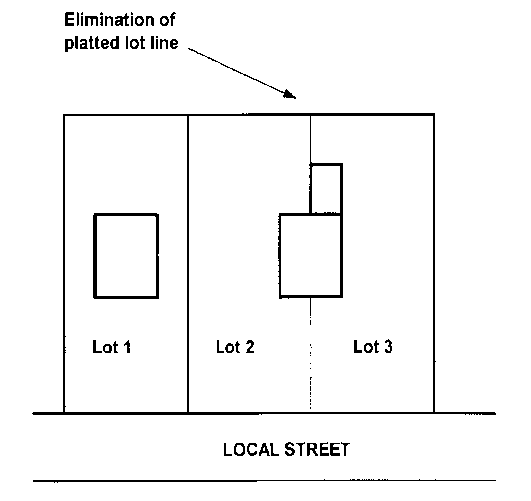
(a)
An existing lot line forming the boundary between two conforming platted lots located within the same subdivision or a lot line between lots or parcels that have merged to form one building lot may be removed or eliminated through a final plat revision process which conforms to the final plat requirements of this article.
(b)
Where separate lots of land are proposed to be combined, they shall be submitted to the department of public development as a final plat for review and approval. In the case no final plat applies to the subject lots or parcels, a boundary survey and plat depicting all lots involved in the lot combination shall be required to be approved by the department of public development as a final plat.
(c)
Such combination plat shall be titled with the same name as that of the original subdivision, if applicable, and shall indicate thereon that the replat is for the purpose of removing the lot lines between specific lots.
(Ord. No. 17-003, § 1, 10-2-2017)
Sec. 1569. - Boundary line adjustment.
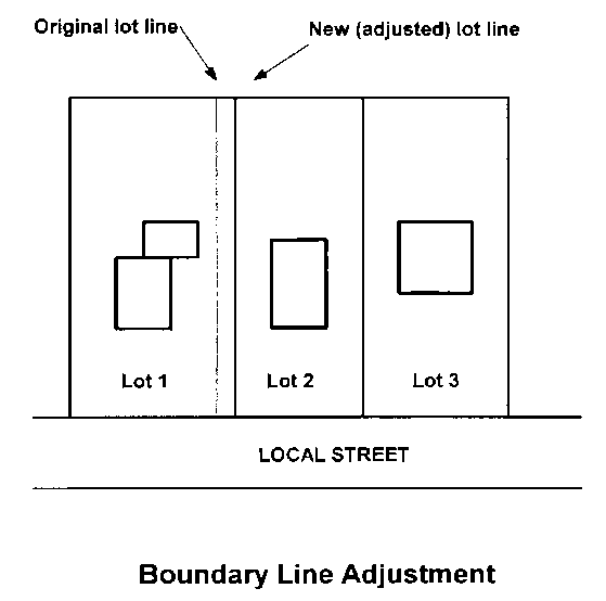
(a)
One or more existing lot lines forming boundaries between conforming platted lots located within the same subdivision, or one or more lot lines between abutting lots or parcels may be adjusted through a final plat revision process that requires the approval of the public development department and recording of a plat meeting the specifications of a final plat. In the case no final plat applies to the subject lots or parcels, a boundary survey and plat of the entire lots involved in the boundary line adjustment shall be required to be approved by the public development department.
(b)
Such plat showing said boundary line adjustment shall be titled with the same name as that of the original subdivision and shall include thereon that the replat is for the purpose of adjusting the lot lines between specific lots.
(Ord. No. 17-003, § 1, 10-2-2017)
Sec. 1571. - Application for final plat.
Applications for final plat approval shall include the following:
(a)
Application form. Completion of an application form with information specified by the public development department, including but not limited to owner information. The owner, or agent if so authorized, shall sign the application attesting to the accuracy of the application and confirming authority and intent to submit the application for consideration.
(b)
Copies of plat. Copies of the final subdivision plat in a number as established by the public development department, showing the entire ownership and drawn to the specifications required by division V of this article.
(c)
Legal description of lots. A legal description for each lot in the subdivision shall be provided.
(d)
Fee. Payment of the applicable application and review fees as established by the Jackson County Board of Commissioners from time to time for a final plat.
(e)
Payment for signs and striping. Payment for materials and installation of traffic signs and street name signs in an amount determined by the Jackson County Roads Superintendent. Payment of the cost of street striping or signalization, if required and not completed by the owner, shall also be included with the application.
(f)
Financial guarantee of improvements. For major subdivisions involving public improvements, a subdivision improvement guarantee as specified in this division VII of this article.
(g)
Protective covenants and homeowners' association documents. If required by provisions of this UDC, a homeowners' association shall be created and the instruments of such creation and financial endowment shall be recorded at the time of final plat recording. Similarly, if a property owners association is required by this UDC or established by the developer, such association shall be created and instruments of creation and financial endowment shall be required at the time of final plat recording. Two copies of the recorded instruments or instruments to be recorded shall be filed with the public development department.
(h)
A stormwater management maintenance agreement as required by section 1146 of this UDC.
(i)
When street lights are involved in the final plat, a mechanism for payment of the operational costs of street lighting which may include a special tax district as specified in section 34-132 of the Jackson County Code of Ordinances. Once a final plat involving a special tax district for street lights has been approved by the public development department and recorded by the clerk of superior court, the utility bill for street lights shall be transferred over to the county government for payment. Subsequently, payment will be recovered through property taxes from properties located within the special tax district.
(Ord. No. 17-003, § 1, 10-2-2017; Ord. No. 24-005, § 1, 8-19-2024)
Sec. 1572. - Process for review and approval of a final plat.
Upon completion of all requirements, the subdivider or property owner can file an application for final plat approval. The procedures for final plat review and action shall be as specified in this section.
(a)
Review for completeness and application acceptance. The public development department shall review the final plat application for completeness within no more than thirty calendar days from the posted submission deadline. Incomplete applications will not be processed and will be returned to the applicant.
(b)
Distribution and agency review of final plat. The public development department may forward a copy of the final plat application to other county departments as may be appropriate, the Georgia Department of Transportation if the proposed subdivision has frontage on or proposes access to a state or federal road. The applicant shall be required to obtain approval from the Jackson County Environmental Health Department if septic tanks are proposed within a major subdivision, and public utility providers in cases where connection to public water and/or sewer is proposed or required.
(c)
Time period for completion of review. Except for final plats that have frontage on or propose access to a state or federal road which require review by the Georgia Department of Transportation (which require a 30-day review period), within no more than 25 calendar work days following receipt of a complete final plat application, during which agency review shall be completed, the public development department shall indicate on the final plat or in writing all comments related to compliance with this article and the UDC. The department shall provide all comments to the applicant for resolution, who shall work with each department as necessary to resolve all issues.
(d)
Action. When the department of public development has determined that the final subdivision plat is in compliance with the approved preliminary plat for the subdivision (if applicable) and the requirements of this UDC and consistent with the comprehensive plan, it shall be approved. The owner shall be responsible for compliance with all codes, regulations, and zoning requirements and for the satisfaction of all the noted and written comments. If it is determined that the final plat is not in compliance with the requirements of this UDC, the department shall disapprove the final plat. Action must be taken by the department to approve, conditionally approve, or disapprove the final plat application within no more than 45 days from receipt of a completed application.
(Ord. No. 17-003, § 1, 10-2-2017)
Sec. 1573. - Recording of final plat.
(a)
Once the final subdivision plat has received approval as evidenced by the certificate of final plat approval, the applicant shall record the plat electronically with the Jackson County Clerk of Superior Court.
(b)
The applicant is responsible for paying any required recording fees.
(c)
All plats must be in the Georgia Coordinate System West Zone NAD 83 before the plat is recorded. If the project is within 1,000 feet of a Jackson County geodetic monument the plat must use the monument as a control/tie point. The applicant for final plat approval shall be responsible for forwarding an electronic copy of the final plat as recorded, along with recording information, to the department of public development. In addition, the subdivision applicant shall submit electronic (DWG/DXF and PDF) file copies of lot boundaries of subdivisions and related information as specified by the public development director and the director of geographic information services. Building permits may be withheld pending receipt of the electronic files and copy of the recorded final plat.
(d)
Recordation of a final plat constitutes approval to begin the sale or transfer of subdivision lots.
(Ord. No. 17-003, § 1, 10-2-2017)
Sec. 1574. - Distribution of approved final plat.
The final plat is a source of essential information to tax officials, public safety officials, and utility officials, among others. Accordingly, the public development department may forward recorded final plats to appropriate departments and agencies, such as the Jackson County Emergency Services Department; the county building official; the county road superintendent; and The United States Postal Service (local postmaster). At the discretion of the public development director, additional agencies or persons may be added to the distribution list.
(Ord. No. 17-003, § 1, 10-2-2017)
Sec. 1575. - Revision of final plat.
The application requirements and procedures for amending final plats shall be the same as for final plat applications.
(Ord. No. 17-003, § 1, 10-2-2017)
Sec. 1581. - Subdivision improvement guarantee.
(a)
Improvements. All public improvements required for subdivisions shall have been properly installed and completed in accordance with all requirements and standards of this UDC (other than traffic signs, street name signs, street striping, and signalization) prior to final plat approval.
(b)
Submission. Prior to approval of a final subdivision plat, a subdivision improvement guarantee in a form acceptable to the public development director and county attorney is required for all completed improvements shown on the as-built surveys required by this UDC. Prior to final plat approval, the owner of a subdivision involving public improvements shall submit a subdivision improvement guarantee.
(c)
Maintenance period and duration of guarantee. The subdivider shall maintain any public improvements in the subdivision, for a period of two years or until certificates of occupancy have been issued for 75 percent or more of the principal buildings on the lots shown on the final subdivision plat, whichever occurs later. The two-year maintenance period shall begin upon recordation of the final subdivision plat. If the two-year term expires before the issuance of certificates of occupancy for 75 percent or more of the principal buildings on the lots shown on the final subdivision plat, the improvement guarantee shall be renewed or extended, until certificates of occupancy have been issued on 75 percent of the principal buildings on the lots shown on the final subdivision plat. The subdivider shall not assign this responsibility to another entity without permission of the county attorney and public development director.
(d)
Amount of guarantee. The value of the improvement guarantee shall be equal to $15.00 per linear foot of street improvements shown on the as-built surveys or final plat. The cost of construction shall be evidenced by copies of contractor agreements or actual invoices paid, or as otherwise determined or accepted by the public development director.
(e)
Inspection. Prior to the end of the maintenance period, the subdivider shall request an inspection of the subdivision's public improvements. The public development department shall perform the inspection. The subdivider shall be notified of the inspection results in writing at least 30 days prior to receipt of a request from the subdivider to the county to initiate an inspection.
(f)
Repairs. If repairs are needed for the public improvements to meet county specifications during the two-year maintenance period, the subdivider shall be required to make such repairs within 30 days, after written notification by the public development director. The subdivider must correct all defects or deficiencies in materials or workmanship and make such repairs as necessary to approximate the as-built condition of the improvements. When the subdivider completes the necessary maintenance repairs, he or she shall request in writing that the public development department inspect the repairs. The public development department shall inspect the repairs and notify the developer of the inspection results.
(g)
Remedy. If the repairs are not completed, the subdivision improvement guarantee shall be called to pay for the repairs. Should the amount of the subdivision improvement guarantee be inadequate to pay for the repairs, the developer shall pay the remaining amount. The county may withhold building permits if the remaining amount required by this paragraph is not paid.
(Ord. No. 17-003, § 1, 10-2-2017)
Sec. 1582. - Warranty deed and resolution of acceptance.
Subdivision streets and rights-of-way and other lands to be dedicated to the public shall be accepted by the county only upon the approval by the Jackson County Board of Commissioners of a general warranty deed conveying fee simple title of such rights-of-way and lands. The warranty deed shall be accompanied by a certificate of title and a tax transfer form addressed to the Jackson County Board of Commissioners, certifying that the grantor in such deed is vested with marketable fee simple title to the property conveyed thereby, free and clear of all liens and encumbrances, and further that the individual executing such deed has full authority to do so. The subdivider shall forward executed deeds for the streets, and dedication of other public properties if applicable, to the public development director who will schedule the matters for the next available meeting of the Jackson County Board of Commissioners for consideration, and if approved, recording, along with a resolution accepting the public improvements for perpetual maintenance.
(Ord. No. 17-003, § 1, 10-2-2017)
Sec. 1583. - Release of improvement guarantee.
Upon adoption by the Jackson County Board of Commissioners of a resolution accepting the public improvements within the subdivision for perpetual maintenance, the improvement guarantee shall be released by the public development director.
(Ord. No. 17-003, § 1, 10-2-2017)