
Jackson County Unincorporated
City Zoning Code
City Zoning Code
ARTICLE 11
- STORMWATER MANAGEMENT
Sec. 1101. - Title.
This article shall be known as the "Jackson County Stormwater Management Ordinance."
(Ord. No. 17-003, § 1, 10-2-2017)
Sec. 1102. - Findings.
(a)
Land development projects and other land use conversions, and their associated changes to land cover, permanently alter the hydrologic response of local watersheds and increase stormwater runoff rates and volumes, which in turn increase flooding, stream channel erosion, and sediment transport and deposition.
(b)
Land development projects and other land use conversions also contribute to increased nonpoint source pollution and degradation of receiving waters.
(c)
The impacts of post-development stormwater runoff quantity and quality can adversely affect public safety, public and private property, drinking water supplies, recreation, fish and other aquatic life, property values and other uses of lands and waters.
(d)
These adverse impacts can be controlled and minimized through regulation of stormwater runoff quantity and quality from land development by the use of structural facilities as well as nonstructural measures, such as the conservation of greenspace.
(e)
Compliance by local governments in the state of Georgia with a number of both state and federal laws, regulations and permits is mandated to address the impacts of post-development stormwater runoff quality and nonpoint source pollution.
(f)
It is reasonable to establish this set of stormwater management requirements to regulate post-development stormwater runoff for protecting local water resources from degradation. The regulation of post-development stormwater runoff discharges in order to control and minimize increases in stormwater runoff rates and volumes, post-construction soil erosion and sedimentation, stream channel erosion and nonpoint source pollution associated with post-development stormwater runoff is in the public interest.
(Ord. No. 17-003, § 1, 10-2-2017)
Sec. 1103. - Purpose.
The purpose of this article is to protect, maintain and enhance the public health, safety, environment and general welfare by establishing minimum requirements and procedures to control the adverse effects of post-development stormwater runoff and nonpoint source pollution associated with development. Proper management of post-development stormwater runoff will minimize damage to public and private property and infrastructure, safeguard the public health, safety, environment and general welfare and protect water and aquatic resources.
(Ord. No. 17-003, § 1, 10-2-2017)
Sec. 1104. - Definitions.
Applicant: A person submitting a stormwater management plan for approval.
As-built survey drawings: Drawings specifying the dimensions, location, fixtures, elements, sizes, capacities and operational capabilities of streets and stormwater structures and facilities, and water and sewer systems, as they have been constructed.
Bioretention: A practice to manage and treat stormwater runoff by using a conditioned planting soil bed and planting materials to filter runoff stored within a shallow depression. The method combines physical filtering and adsorption with biological processes.
Channel: A natural or artificial watercourse with a definite bed and banks that conducts continuously or periodically flowing water.
Clean Water Act: The Federal Water Pollution Control Act (33 U.S.C. § 1251 et seq.), and any subsequent amendments thereto.
Conservation easement: An agreement between a land owner and the local jurisdiction or other government agency or land trust that permanently protects open space or greenspace on the owner's land by limiting the amount and type of development that can take place, but continues to leave the remainder of the fee interest in private ownership.
Construction activity: Activities subject to the Georgia Erosion and Sedimentation Control Act or NPDES general construction permits. These include construction projects resulting in land disturbance. Such activities include but are not limited to clearing and grubbing, grading, excavating, and demolition.
Conveyance: An aboveground or underground natural or man-made drainage feature, that provides for the collection and movement of stormwater, and shall include but not be limited to concrete or metal pipes, ditches, depressions, swales, roads with drainage systems, highways, county streets, curbs, gutters, inlets, catch basins, piped storm drains, pumping facilities, structural stormwater controls, drainage channels, reservoirs, rights-of-way, storm drains, culverts, street gutters, oil/water separators, modular pavements and other similar drainage structures.
County: Jackson County and its departments, employees and agents as may have duties and responsibilities for administering and enforcing all stormwater management activities and implementation of the provisions of this article.
County separate storm sewer system: Any conveyance of system of conveyances which is: owned or operated by the county; not a combined sewer; and not part of a publicly owned treatment works.
Detention: The temporary storage of stormwater runoff in a stormwater management facility for the purpose of controlling peak discharge.
Detention facility: A retention basin or structure designed for temporary storage of stormwater runoff and gradual release of stored water at controlled rates.
Developer: A person who undertakes land development activities.
Development: A land development or land development project; the term "development" also encompasses "redevelopment."
Drainage: A general term applied to the removal of surface or subsurface water from a given area either by gravity or by pumping; most commonly applied to surface water.
Drainage easement: An easement appurtenant or attached to a tract or parcel of land allowing the owner of adjacent tracts or other persons to discharge stormwater runoff onto the tract or parcel of land subject to the terms of the drainage easement.
Drainage structure: A device composed of a virtually non-erodible material such as concrete, steel, plastic or other such material that conveys water from one place to another by intercepting the flow and carrying it to a release point for stormwater management, drainage control or flood control purposes.
Drainage system: The surface and subsurface system for the removal of water from the land, including both the natural elements of streams, marshes, swales and ponds, whether of an intermittent or continuous nature, and the man-made element which includes culverts, ditches, channels, detention facilities and the storm sewer system.
Dry well: A small excavated pit backfilled with aggregate, usually pea gravel or stone. Dry wells function as infiltration systems used to control runoff from building rooftops. Another special application of dry wells is modified catch basins, where inflow is a form of direct surface runoff. Dry wells provide the majority of treatment by processes related to soil infiltration, including absorption, trapping, filtering, and bacterial degradation.
Erosion and sedimentation control plan: A plan designed to minimize the accelerated erosion and sediment runoff at a site during land disturbance activities.
Extended detention: The detention of stormwater runoff for an extended period, typically 24 hours or greater.
Extreme flood protection: Measures employed to prevent adverse impacts from large low-frequency storm events with a return frequency of 100 years or more.
Filter strip: Typically, a band of close-growing vegetation, usually grass, planted between pollutant source areas and a downstream receiving waterbody. Vegetation can filter sediment from runoff. Thus grass strips can be used to remove sediment from surface runoff. Vegetation also slows the velocity of runoff and helps maintain the infiltration capacity of a soil.
Flooding: A volume of surface water that is too great to be confined within the banks or walls of a conveyance or stream channel and that overflows onto adjacent lands.
Georgia Stormwater Management Manual: A three-volume set which provides policy and technical details to implement this article. The manual may be revised from time to time but at the time this article is adopted includes: Volume 1: Local Government Guide (2016 Editions); Volume 2: Technical Handbook (2016 Edition); and Volume 3; Pollution Prevention Guidebook (2012).
Greenspace or open space: Permanently protected areas of a site that are preserved in a natural, undisturbed state. Greenspace encompasses "open space." Land conservation and impervious cover reduction is a major goal of open space.
Hotspot: Any area where the use of the land has the potential to generate highly contaminated runoff characterized by concentrations of pollutants in excess of those typically found in stormwater.
Hydrologic soil group (HSG): A natural resource conservation service classification system in which soils are categorized into four runoff potential groups. The groups range from "group a" soils, with high permeability and little runoff produced, to "group d" soils, which have low permeability rates and produce significantly more runoff.
Impervious cover: A surface composed of any material that significantly impedes or prevents the natural infiltration of water into soil. Impervious surfaces include, but are not limited to, rooftops, buildings, streets and roads, and any concrete or asphalt surface.
Industrial stormwater permit: A National Pollutant Discharge Elimination System (NPDES) permit issued to an industry or group of industries that regulates the pollutant levels associated with industrial stormwater discharges or specifies on-site pollution control strategies.
Infiltration: The process by which stormwater runoff percolates into the subsoil.
Infiltration trench: An excavated trench that has been back-filled with stone to form a subsurface basin. Stormwater runoff is diverted into the trench and is stored until it can be infiltrated into the soil, usually over a period of several days. An infiltration trench may include pretreatment such as vegetated filter strips or grassed swales.
Inspection and maintenance agreement: A written agreement providing for the long-term inspection and maintenance of stormwater management facilities and practices on a site or, with respect to a land development project, which when properly recorded in the deed records constitutes a restriction on the title to a site or other land involved in a land development project.
Jurisdictional wetland: An area that is inundated or saturated by surface water or groundwater at a frequency and duration sufficient to support a prevalence of vegetation typically adapted for life in saturated soil conditions, commonly known as hydrophytic vegetation.
Land development: Any alteration to the land including, but not limited to, clearing, cutting, digging, grubbing, stripping, removal of vegetation, dredging, grading, excavating, transporting and filling of land, construction, paving and any installation of impervious cover.
Land development activities: Those actions or activities that comprise, facilitate or result in land development.
Land development project: A specific land development undertaking.
Level spreader: Typically, an outlet designed to convert concentrated runoff to sheet flow and disperse it uniformly across a slope to prevent erosion. Level spreaders can be used to convey sheet flow runoff from lawn areas within graded areas to bioretention facilities and transition areas.
Low-impact development (LID): The integration of site ecological and environmental goals and requirements into all phases of urban planning and design from the individual lot level to the entire watershed. In the context of this article, low-impact development is a set of stormwater design practices that are non-structural stormwater controls, specifically stormwater better site design practices.
National Pollutant Discharge Elimination System (NPDES) stormwater discharge permit: A permit issued by the Georgia EPD under authority delegated pursuant to 33 USC § 1342(b) that authorizes the discharge of pollutants to waters of the United States, whether the permit is applicable on an individual, group, or general area-wide basis.
Natural, undisturbed conditions: For redevelopment projects or where there are no flooding concerns, this term shall mean the condition of the site immediately prior to the implementation of the proposed project.
New development: A land development activity on a previously undisturbed site that has been maintained in a natural state.
Nonpoint source pollution: A form of water pollution that does not originate from a discrete point such as a sewage treatment plant or industrial plant discharge, but involves the transport of pollutants such as sediment, fertilizers, pesticides, heavy metals, oil, grease, bacteria, organic materials and other contaminants from land to surface water and groundwater via mechanisms such as precipitation, stormwater runoff and leaching. Nonpoint source pollution is a by-product of land use practices such as agricultural, silvicultural, mining, construction and subsurface disposal as well as from urban runoff sources.
Nonstructural stormwater management practice or nonstructural practice: Any natural or planted vegetation or other nonstructural component of the stormwater management plan that enhances stormwater quantity and/or quality control or other stormwater management benefits and includes, but is not limited to, riparian buffers, greenspace areas, overland flow filtration areas, natural basins and vegetated channels.
Off-site facility: A stormwater management facility located outside the boundaries of a development site.
On-site facility: A stormwater management facility located within the boundaries of a development site.
Overbank flood protection: Measures employed to prevent an increase in the frequency and magnitude of out-of-bank flooding, that is, flow events that exceed the capacity of the channel and enter the floodplain. Such measures are intended to protect downstream properties from flooding during a two-year through 25-year frequency storm events.
Owner: The legal or beneficial owner of a site including, but not limited to, a mortgagee or vendee in possession, receiver, executor, trustee, lessee or other person, firm or corporation in control of the site.
Permeable: Soil or other material that allows the infiltration or passage of water or other liquids.
Permit: The permit issued by Jackson County to an applicant that is required for conducting any land development activity.
Person: Except to the extent exempted from this article, any individual, partnership, firm, association, joint venture, public or private corporation, trust, estate, commission, board, public or private institution, utility, cooperative, city, county or other political subdivision of the state, any interstate body or any other legal entity.
Pollutant: Anything that causes or contributes to pollution. Pollutants may include, but are not limited to: paints, varnishes, and solvents; petroleum hydrocarbons; automotive fluids; cooking grease; detergents (biodegradable or otherwise); degreasers; cleaning chemicals; non-hazardous liquid and solid wastes and yard wastes; refuse, rubbish, garbage, litter, or other discarded or abandoned objects and accumulations, so that same may cause or contribute to pollution; floatables; pesticides, herbicides, and fertilizers; liquid and solid wastes; process waste water and wash water; sewage, fecal coliform and pathogens; dissolved and particulate metals; animal wastes; wastes and residues that result from constructing a building or structure; concrete and cement; and noxious or offensive matter of any kind.
Pollution: The man-made or man-induced alteration of the chemical, physical, biological, thermal and radiological integrity of water.
Post-development: The period, or conditions that may reasonably be expected to exist, following completion of land development activity on a site as the context may require.
Pre-development: The period, or conditions that exist on a site, prior to commencement of a land development project and at the time that plans for development of a site are approved by Jackson County. Where phased development or plan approval occurs, for example, preliminary grading and installation of roads and utilities, the existing site conditions at the time prior to commencement of any development activity shall establish pre-development conditions.
Premises: Any building, lot, parcel of and/or portion of land whether improved or unimproved, including adjacent sidewalks and parking strips.
Project: A land development project.
Redevelopment: A land development project on a previously developed site, but excluding ordinary maintenance, remodeling of existing buildings, resurfacing of paved areas, and exterior alterations or improvements that do not materially increase or concentrate stormwater runoff or cause additional nonpoint source pollution.
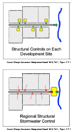
Regional stormwater management facility or regional facility: Stormwater management facilities designed to control stormwater runoff from multiple properties where the owners or developers of the individual properties may assist in financing the facility and the requirement for on-site stormwater management facilities is either eliminated or reduced.
Runoff: Stormwater runoff.
Site: A parcel of land being developed or the portion thereof on which a land development project is located.
Stormwater better site design: Nonstructural site design approaches and techniques that can reduce the impact of a site on the watershed and can provide for nonstructural stormwater management. Stormwater better site design includes conserving and protecting natural areas and greenspace, reducing impervious cover and using natural features for stormwater management.
Stormwater credits for better site design: A set of stormwater "credits" can be used to provide developers and site designers an incentive to implement better site design practices that can reduce the volume of stormwater runoff and minimize the pollutant loads from a site. The credit system directly translates into cost savings to the developer by reducing the size of structural stormwater control and conveyance facilities.
Stormwater management: The collection, conveyance, storage, treatment and disposal of stormwater runoff in a manner intended to prevent increased flood damage, stream bank channel erosion and habitat and water quality degradation, and to enhance and promote public health, safety and general welfare.
Stormwater management facility: Any infrastructure that controls or conveys stormwater runoff.
Stormwater management measure: Any stormwater management facility or nonstructural stormwater practice.
Stormwater management plan: A document describing the manner in which existing runoff characteristics will be affected by a land development project and containing measures for complying with the provisions of this article.
Stormwater management system: The full array of structural and nonstructural stormwater management facilities and practices used to capture, convey and control the quantity and quality of the stormwater runoff from a site.
Stormwater retrofit: A stormwater management practice designed for a developed site that previously had either no stormwater management practice in place or a practice inadequate to meet the stormwater management requirements of the site.
Stormwater runoff: The flow of surface water resulting from precipitation.
Structural stormwater control: A structural stormwater management facility or device that controls stormwater runoff and changes the characteristics of that runoff including, but not limited to, the quantity and quality, the period of release or the velocity of flow of such runoff.
Subdivision: The division of a tract or parcel of land resulting in one or more new lots or building sites for the purpose, whether immediately or in the future, of sale, other transfer of ownership or land development, and includes divisions of land resulting from or made in connection with the layout or development of a new street or roadway or a change in an existing street or roadway.
Swale: An open drainage channel designed to detain or infiltrate stormwater runoff. Grassed swales consist of two types: the dry swale, which provides both quantity (volume) and quality control by facilitating stormwater infiltration; and the wet swale, which uses residence time and natural growth to reduce peak discharge and provide water quality treatment before discharge to a downstream location.
(Ord. No. 17-003, § 1, 10-2-2017; Ord. No. 19-002, 10-21-2019)
Sec. 1105. - Applicability.
(a)
No person, owner or developer shall perform any land development activities without first meeting the applicable requirements of this article prior to commencing the proposed activity.
(b)
Unless specifically exempted by this article, all persons proposing development or construction in the unincorporated portion of the county shall prepare and submit a stormwater management plan for approval by the director of public development as a part of the land-disturbing and/or development permitting process required by this UDC, (article 8 UDC) and shall also comply with all applicable requirements of this article.
(Ord. No. 17-003, § 1, 10-2-2017)
Sec. 1106. - Exemptions.
The following activities are exempt from this article:
(a)
Individual single-family or duplex residential lots that are not part of a subdivision or phased development project;
(b)
Additions or modifications to existing single-family or duplex residential structures;
(c)
Agricultural or silvicultural land management activities within areas lawfully used or zoned for these activities;
(d)
Repairs to any stormwater management facility or practice deemed necessary by the public development director; and
(e)
Land disturbing activity conducted by local, state, authority, or federal agencies, solely to respond to an emergency need to protect life, limb, or property or conduct emergency repairs.
(Ord. No. 17-003, § 1, 10-2-2017)
Sec. 1107. - Approval of stormwater management plan.
No final plat for a major subdivision, no land-disturbance or development permit, and no building permit shall be approved or issued until and unless the stormwater management plan, if required by this article, has been reviewed and approved by the director of public development.
(Ord. No. 17-003, § 1, 10-2-2017)
Sec. 1108. - Installation of an adequate drainage system.
(a)
An adequate drainage system, including necessary ditches, pipes, culverts, drains, inlets, or other stormwater management features which may include better sign design practices, shall be provided for the proper drainage or infiltration of all surface water on all development and construction sites unless specifically exempted by this article.
(b)
The location and size of all proposed drainage improvements shall be designed in accordance with and meet all standards relating to stormwater drainage under this article and technical standards of this UDC as applicable.
(c)
Stormwater drainage facilities shall be installed in accordance with the approved stormwater management plan. Construction of the stormwater system shall be initiated as part of the grading of the site. Stormwater detention facilities/ponds shall be constructed to have a minimum of four to one side slopes. Stormwater detention facilities/ponds are to be broader, shallower and flatter for ease of maintenance and for aesthetic purposes. Stormwater detention facilities shall be constructed prior to the installation of any other site improvements, and may be utilized under proper design as sedimentation basins during development. Installation of all other storm drainage pipes, culverts, headwalls, and ditches, shall be coordinated with the construction of streets and other site improvements, as appropriate.
(Ord. No. 17-003, § 1, 10-2-2017; Ord. No. 22-004, § 2, 5-16-2022)
Sec. 1109. - System maintenance.
(a)
It shall be the responsibility of the developer to maintain all facilities required by the stormwater management plan during construction and for a two-year maintenance period following approval of the final subdivision plat or issuance of a certificate of occupancy, as applicable. The developer shall be responsible for removing temporary structures or facilities at the completion of the construction.
(b)
The owner of the property shall be responsible for maintaining the permanent stormwater management facilities identified by the stormwater management plan to remain after construction is complete, following the two-year maintenance period.
(c)
Should an owner or developer, whichever is the responsible party, fail to maintain the stormwater management facilities in a state of service intended by the stormwater management plan, then the public development department shall notify the responsible party in writing of the deficiencies and specific minimum maintenance requirements to remedy such deficiencies.
(d)
If the responsible party fails to perform the required maintenance work within a reasonable period of time (30 days maximum), then the owner shall be in violation of the provisions of this UDC.
(Ord. No. 17-003, § 1, 10-2-2017)
Sec. 1110. - Location of stormwater detention facilities.
(a)
In residential subdivisions, any detention facility must be located on a separate lot and owned by a homeowners' association, which shall be responsible for its maintenance and continuing operation. The lot need not meet minimum lot size requirements for the subdivision.
(b)
In nonresidential subdivisions, any detention facility may be located on a separate lot and owned by a property owners' association, which shall be responsible for its maintenance and continuing operation; or located on each lot within the subdivision and constructed when the lot is developed.
(c)
In multi-family and nonresidential development projects, separate detention facilities shall be provided for each development. The owner of the property shall be responsible for maintenance and continuing operation of the facility.
(d)
Stormwater detention facilities serving two or more developments may be approved by the county, provided that private ownership of the facilities and provisions for their perpetual maintenance and continuing operation are clearly established in a manner acceptable to the county attorney.
(Ord. No. 17-003, § 1, 10-2-2017)
Sec. 1111. - Relationship to other regulations.
The requirements of this article are in addition to the requirements of any other ordinance, rule, regulation or other provision of law, and where any provision of this article imposes restrictions different from those imposed by any other ordinance, rule, regulation or other provision of law, whichever provision is more restrictive or imposes higher protective standards for human health or the environment shall control.
(Ord. No. 17-003, § 1, 10-2-2017)
Sec. 1121. - Applicability.
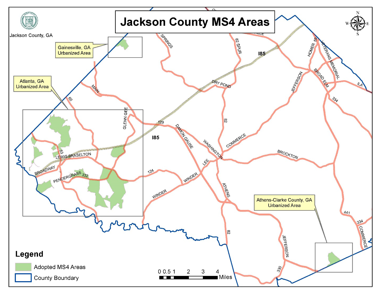
This division shall apply to land development projects (not otherwise exempt from compliance with this article) in the unincorporated area of Jackson County and outside of the urbanized area of unincorporated Jackson County, or in other words, those areas outside of the MS4 program of unincorporated Jackson County.
(Ord. No. 17-003, § 1, 10-2-2017)
Sec. 1122. - Contents of stormwater management plan.
A stormwater management plan, when required, shall include sufficient information to evaluate the environmental characteristics of the affected areas, the potential impacts of the proposed development on water resources, and the effectiveness and acceptability of measures proposed for managing stormwater runoff. Said information shall at minimum include a site plan of the proposed land development and building and the following:
(a)
Size and location of existing storm sewers, drains, culverts, or other underground facilities within the tract or within the right-of-way of streets or roads adjoining the tract. Grades and invert elevations of storm sewers shall be shown.
(b)
Location and profiles of all storm drainage pipes and slopes of receiving channels.
(c)
Hydraulic grade lines shall be shown on all pipes that cross streets and on all detention basin outfalls.
(d)
Stormwater detention facility location, design and construction details, including a soils map and investigation for all sites proposed as ponds or impoundments or for stormwater detention. Stormwater detention facilities/ponds shall be constructed to have a minimum of four to one side slopes. Stormwater detention facilities/ponds are to be broader, shallower and flatter for ease of maintenance and for aesthetic purposes. Construction details shall include appropriate access (minimum 20-foot wide access easement), a gravel access drive, fencing with locked gate, and landscaping to screen the installation.
(e)
Location and typical construction details of all inlets and catch basins, headwalls and other drainage structures.
(f)
The 100-year ponding limits above each street cross drain, where provided.
(g)
Hydrologic and hydraulic analysis for the storm drainage system design.
(h)
Construction schedule for both temporary and permanent facilities in relation to the schedule for development activities such as clearing, rough grading, construction, final grading, and vegetation establishment.
(i)
A cost estimate for construction of the stormwater management facilities and an estimate of the annual cost for maintenance of the proposed facilities.
(j)
Specific actions and a schedule of maintenance required to maintain the facilities at a satisfactory level of service, which shall be made a part of the private covenants.
(Ord. No. 17-003, § 1, 10-2-2017; Ord. No. 22-004, § 3, 5-16-2022)
Sec. 1131. - Purpose and objectives.
In addition to the purposes and intentions of this article generally, this division seeks to achieve the following objectives:
(a)
Implement decision-making processes and procedures concerning land development that protect the integrity of the watershed and preserve the health of water resources;
(b)
Require that development projects maintain the pre-development hydrologic response in their post-development state as closely as is feasible to reduce flooding, stream bank erosion, nonpoint source pollution and increases in stream water temperature while maintaining the integrity of stream channels and aquatic habitats;
(c)
Establish minimum post-development stormwater management standards and design criteria for regulation and control of stormwater runoff quantity and quality;
(d)
Formulate design and application criteria for the construction and use of structural stormwater control facilities used to achieve minimum post-development stormwater management standards;
(e)
Strongly encourage the implementation of principles of low-impact development, including the use of nonstructural stormwater management and improved stormwater better site design practices such as preservation of greenspace and Georgia Stormwater Management Manual;
(f)
Establish provisions for the long-term responsibility for and maintenance of structural stormwater control facilities and nonstructural stormwater management practices to ensure such facilities continue to function as designed, are maintained, and pose no threat to public safety; and
(g)
Adopt administrative procedures for submission and review of stormwater management plans, for the monitoring and inspection of projects under construction, and for long-term follow up inspection of completed projects.
(Ord. No. 17-003, § 1, 10-2-2017)
Sec. 1132. - Applicability.
This division shall apply to all of the following land development activities, including, but not limited to, site plan applications, subdivision applications and grading applications, unless specifically exempt by this article, in the unincorporated area of Jackson County and inside the urbanized area of unincorporated Jackson County, or in other words, those areas inside of the MS4 program of unincorporated Jackson County (see map):
(a)
New development involving creation of 5,000 square feet or more of impervious cover or involving other land development activity affecting an area comprising one acre or more;
(b)
Redevelopment that includes creation, addition or replacement of 5,000 square feet or more of impervious cover or involving other land development activity affecting an area comprising one acre or more;
(c)
Any new development or redevelopment, regardless of size, defined to be a "hotspot" land use, and any commercial or industrial new development or redevelopment, regardless of size, with at standard industrial classification (SIC) code or North American Industrial Classification System Code (NAICS) that falls under the NPDES industrial stormwater permit program; and
(d)
Land development activities that are below the minimum thresholds established in this section, when such activities are part of a larger development plan, even though multiple, separate and distinct land development activities may occur at different times and on different schedules.
(Ord. No. 17-003, § 1, 10-2-2017)
Sec. 1133. - Georgia stormwater management manual.
Jackson County hereby adopts and will utilize in the urbanized area of unincorporated Jackson Country only, the policy, criteria and information, including technical specifications and standards, in the latest edition of the Georgia Stormwater Management Manual (GSMM) and any relevant local addenda, for proper implementation of the requirements of this division. The manual may be updated and expanded periodically, based on improvements in science, engineering, monitoring and local maintenance experience. It is the county's intent in adopting the manual to, in particular, apply stormwater better site design practices and credits for the implementation of stormwater better site design practices.
(Ord. No. 17-003, § 1, 10-2-2017)
Sec. 1134. - Water quality.
All stormwater runoff generated by any site shall be adequately treated prior to discharge. A stormwater management system will be deemed in compliance with this standard provided the following requirements are met:
(a)
The system is appropriately sized to treat the prescribed water quality treatment volume generated by the site as defined in the GSMM;
(b)
Appropriate structural stormwater controls or nonstructural practices are selected, designed, constructed or preserved and maintained according to the specific criteria in the GSMM. Emphasis will be placed by Jackson County on encouraging the use of nonstructural practices; and
(c)
Runoff from hotspot land uses and activities identified by Jackson County is adequately treated and addressed through the use of appropriate structural stormwater controls, nonstructural practices and pollution prevention practices.
(Ord. No. 17-003, § 1, 10-2-2017)
Sec. 1135. - Stream channel protection.
Protection of stream channels from bank and bed erosion and degradation shall be provided by using all of the following three approaches:
(a)
Preservation, restoration and re-vegetation or re-forestation using native plant species of the applicable stream buffer;
(b)
Twenty-four-hour extended detention storage of the one-year, 24-hour return frequency storm event (this requirement may be adjusted or waived by Jackson County for sites that discharge directly into larger streams, rivers, wetlands, or lakes, or to a man-made channel or conveyance system where the reduction in these flows will not have an impact on upstream or downstream stream bank or channel integrity); and
(c)
Erosion prevention measures, such as energy dissipation and velocity controls.
(Ord. No. 17-003, § 1, 10-2-2017)
Sec. 1136. - Overbank flooding protection.
Downstream overbank flood and property protection shall be provided by controlling or attenuating the post-development peak discharge rate to the pre-development rate for the 25-year, 24-hour return frequency storm event. In instances where control of the one-year, 24-hour storm under this article is exempted, peak discharge rate attenuation of the two-year through the 25-year return frequency storm event must be provided. This requirement may be adjusted or waived by Jackson County for sites where the post-development downstream analysis shows that uncontrolled post-development conditions will not increase downstream peak flows, or that meeting the requirement will cause greater peak flow downstream impacts than the uncontrolled post-development conditions.
(Ord. No. 17-003, § 1, 10-2-2017)
Sec. 1137. - Extreme flooding protection.
Extreme flood and public safety protection shall be provided by controlling and safely conveying the 100-year, 24-hour return frequency storm event such that flooding is not exacerbated. This requirement may be adjusted or waived by Jackson County for sites where the post-development downstream analysis shows that uncontrolled post-development conditions will not increase downstream peak flows, or that meeting the requirement will cause greater peak flow downstream impacts than the uncontrolled post-development conditions.
(Ord. No. 17-003, § 1, 10-2-2017)
Sec. 1138. - Structural stormwater controls.
(a)
All structural stormwater management facilities shall be selected and designed using the appropriate criteria from the Georgia Stormwater Management Manual (GSMM).
(b)
All structural stormwater controls shall be appropriately designed to meet the intended function.
(c)
The effectiveness and pollutant removal of the structural controls must be documented through prior studies, literature reviews or other means and be approved by Jackson County prior to being included in the design of a stormwater management system. This standard shall apply to other structural stormwater controls not included in the GSMM, or those for which pollutant removal rates have not been provided. In addition, whenever hydrologic or topographic conditions or land use activities warrant greater control than that provided by the minimum control requirements, Jackson County may impose additional requirements. Such requirements shall be those deemed necessary to protect upstream and downstream properties and aquatic resources from damage due to increased volume, frequency and rate of stormwater runoff or increased nonpoint source pollution loads created on the site.
(d)
Applicants shall consult the GSMM for guidance as concerns the factors that determine site design feasibility when selecting and locating a structural stormwater control.
(Ord. No. 17-003, § 1, 10-2-2017)
Sec. 1139. - Stormwater credits for nonstructural measures.
The use of one or more site design measures by the applicant may permit a reduction in the water quality treatment volume required by this division. The applicant may, subject to approval by Jackson County, take credit for the use of stormwater better site design practices and thereby, reduce the water quality volume requirement. A minimum set of criteria identifies the circumstances under which the credit may be applied. The site design practices that qualify for this credit and the criteria and procedures for applying and calculating the credits are included in the GSMM; see also the definition of "stormwater credits for better site design" in this article.
(Ord. No. 17-003, § 1, 10-2-2017)
Sec. 1140. - Drainage system guidelines.
Stormwater conveyance facilities that may include, but are not limited to, culverts, stormwater drainage pipes, catch basins, drop inlets, junction boxes, headwalls, gutter, swales, channels, ditches and energy dissipaters shall be provided when necessary for the protection of public right-of-way and private property adjoining project sites. Existing or proposed stormwater conveyance facilities designed to carry runoff from more than one parcel shall meet the following requirements:
(a)
Methods to calculate stormwater flows shall be in accordance with the GSMM;
(b)
All culverts, pipe systems and open channel flow systems shall be sized in accordance with the stormwater management plan using methods contained in the GSMM; and
(c)
Design and construction of stormwater conveyance facilities shall be in accordance with the criteria and specifications found in the GSMM.
(Ord. No. 17-003, § 1, 10-2-2017)
Sec. 1141. - Dam design guidelines.
Any land disturbing activity that involves a site on which a dam is proposed shall comply with the Georgia Safe Dams Act and Rules for Dam Safety, as applicable.
(Ord. No. 17-003, § 1, 10-2-2017)
Sec. 1142. - Permit application requirements.
No owner or developer shall perform any land development activities without first meeting the requirements of this section, as applicable. Unless provided otherwise by this article, any owner or developer proposing a land development activity shall submit a permit application to Jackson County on a form provided by the county for that purpose and pay the applicable fee as established by fee schedule. The following information shall accompany a permit application:
(a)
Stormwater concept plan;
(b)
Stormwater management plan;
(c)
Inspection and maintenance agreement, if applicable;
(d)
Performance bond if applicable; and
(e)
Permit application and plan review fees.
(Ord. No. 17-003, § 1, 10-2-2017)
Sec. 1143. - Stormwater concept plan and consultation meeting.
The landowner or developer shall meet with representatives of the department of public development for a consultation meeting on a concept plan for the post-development stormwater management system to be used in the proposed land development project prior to submitting any stormwater management permit application. This consultation meeting shall occur at an early step in the development process. The purpose of this meeting is to discuss the post-development stormwater management measures necessary for the proposed project and to assess constraints, opportunities and approaches for stormwater management design prior to commencing formal site design engineering. During such consultation meetings, the city and applicant will examine the potential applicability of non-structural stormwater controls (stormwater better site design practices). Local watershed plans, as applicable, and any relevant resource protection plans will be consulted in the discussion of the concept plan.
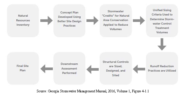
The following information shall be included in the concept plan that shall be submitted prior to the consultation meeting:
(a)
Existing conditions/proposed site plan. Existing conditions and proposed site plan that at a minimum illustrates: existing and proposed topography; perennial and intermittent streams; predominant soils from soil surveys; boundaries of existing predominant vegetation and proposed limits of clearing and grading; and location of existing and proposed roads, buildings, structures, parking areas and all other impervious surfaces;
(b)
Natural resources inventory. A written or graphic inventory of the natural resources on the site and surrounding area as exists prior to commencement of the project. This description shall include a discussion and map of soil conditions (including erodible soils), forest cover, topography (which must include steep slopes (areas with slopes greater than 15 percent), wetlands, and other native vegetative areas on the site, as well as the location and boundaries of other natural feature protection and conservation areas such as wetlands, lakes, ponds, floodplains, aquatic buffers and other setbacks (e.g., drinking water well setbacks, septic setbacks, etc.), natural drainage divides and patterns, natural drainage features, groundwater recharge areas, sensitive natural habitat areas, and protected river corridors. Particular attention must be afforded environmentally sensitive features that represent constraints to development;
(c)
Stormwater management system concept plan. A written or graphic concept plan of the proposed post-development stormwater management system that includes the following information: preliminary selection and location of proposed structural stormwater controls; location of existing and proposed conveyance systems such as grass channels, swales and storm drains; flow paths; location of floodplain/floodway limits; relationship of site to upstream and downstream properties and drainages; and preliminary location of proposed stream channel modifications such as bridge or culvert crossings.
(Ord. No. 17-003, § 1, 10-2-2017)
Sec. 1144. - Stormwater management plan.
(a)
The stormwater management plan shall describe the methods and approaches proposed to control and manage post-development stormwater runoff.
(b)
A description of the measures that will be employed to comply with the standards and requirements of this article, including performance criteria required by this article shall also be provided.
(c)
The stormwater management plan shall be in accordance with the criteria established in this article and be prepared under the direct supervisory control of either a registered professional engineer or a registered landscape architect licensed in the state of Georgia, who shall seal and sign the work. The work shall be conducted under the direct supervisory control of a registered professional engineer. Portions of the overall plan such as boundary surveys, contour maps and erosion and sedimentation control plans may be prepared and stamped by a registered land surveyor licensed in the state of Georgia, as appropriate.
(d)
The stormwater management plan must ensure that the requirements and criteria in this article are met, and that opportunities to minimize adverse post-development stormwater runoff impacts generated by the development are considered. The plan shall consist of maps, narrative, and supporting design calculations (hydrologic and hydraulic) for the proposed stormwater management system (a.k.a, "hydro" study).
(e)
The stormwater management plan for each land development project shall provide for stormwater management measures located on the site of the project, unless provisions are made to manage stormwater by means of an off-site or regional facility.
(Ord. No. 17-003, § 1, 10-2-2017)
Sec. 1145. - Contents of the stormwater management plan.
The plan shall include all information required in the stormwater management site plan checklist found in the GSMM, including the following information:
(a)
General. Common address and legal description of the site, and a vicinity map;
(b)
Existing conditions hydrologic analysis. The existing condition hydrologic analysis for stormwater runoff rates, volumes and velocities, which shall include the following information:
1.
A topographic map of existing site conditions with the drainage basin boundaries indicated;
2.
Acreage, soil types and land cover of areas for each sub-basin affected by the project;
3.
All perennial and intermittent streams and other surface water features;
4.
All existing stormwater conveyances and structural control facilities;
5.
Direction of flow and exits from the site;
6.
Analysis of runoff provided by off-site areas upstream of the project site; and
7.
Methodologies, assumptions, site parameters and supporting design calculations used in analyzing the existing conditions site hydrology. For redevelopment sites, pre-development conditions shall be modeled using the guidelines established by the director of public works for the portion of the site undergoing land development activities.
(c)
Post-development hydrologic analysis. The post-development hydrologic analysis for stormwater runoff rates, volumes and velocities, which shall include the following information:
1.
A topographic map of developed site conditions with the post-development drainage basin boundaries indicated;
2.
Total area of post-development impervious surfaces and other land cover areas for each sub-basin affected by the project;
3.
Calculations for determining the runoff volumes that need to be addressed for each sub-basin for the development project to meet the post-development stormwater management performance criteria of this article;
4.
Location and boundaries of proposed natural feature protection and conservation areas;
5.
Documentation and calculations for any applicable site design credits that are being utilized; and
6.
Methodologies, assumptions, site parameters and supporting design calculations used in analyzing the existing conditions site hydrology. Redevelopment sites on which the land development activity constitutes more than 50 percent of the entire site shall meet the performance criteria of this article as concerns the stormwater runoff from the entire site.
(d)
Stormwater management system. The description, scaled drawings and design calculations for the proposed post-development stormwater management system, which shall include the following information:
1.
A map and/or drawing or sketch of the stormwater management facilities, including the location of nonstructural site design features and the placement of existing and proposed structural stormwater controls, including design water surface elevations, storage volumes available from zero to maximum head, location of inlet and outlets, location of bypass and discharge systems, and all orifice/restrictor sizes;
2.
A narrative describing how the selected structural stormwater controls will be appropriate and effective; cross-section and profile drawings and design details for each of the structural stormwater controls in the system, including supporting calculations to show that the facility is designed according to the applicable design criteria;
3.
A hydrologic and hydraulic analysis of the stormwater management system for all applicable design storms (including stage-storage or outlet rating curves, and inflow and outflow hydrographs);
4.
Documentation and supporting calculations to show that the stormwater management system adequately meets the post-development stormwater management performance criteria of this article;
5.
Drawings, design calculations, elevations and hydraulic grade lines for all existing and proposed stormwater conveyance elements including stormwater drains, pipes, culverts, catch basins, channels, swales and areas of overland flow;
6.
A narrative describing how the stormwater management system corresponds with any watershed protection plans and/or local greenspace protection plan, as applicable; and
7.
A narrative describing the extent to which non-structural stormwater controls, specifically including stormwater better site design practices, are implemented.
(e)
Post-development downstream analysis. A downstream peak flow analysis that includes the assumptions, results and supporting calculations to show safe passage of post-development design flows downstream. The analysis of downstream conditions in the report shall address every point or area along the boundary of the project site at which runoff will exit the property. The analysis shall focus on the portion of the drainage channel or watercourse immediately downstream from the project. This area shall extend downstream from the project to a point in the drainage basin where the project area represents ten percent of the total basin area. In calculating runoff volumes and discharge rates, consideration may need to be given to any planned alteration in future, upstream land use. The analysis shall be in accordance with the GSMM.
(f)
Construction-phase erosion and sedimentation control plan. An erosion and sedimentation control plan in accordance with article 8 of this UDC and the NPDES permit for construction activities. The plan shall also include information on the sequence/phasing of construction and temporary stabilization measures and structures that will be converted into permanent stormwater controls.
(g)
Landscaping and open space plan. A detailed landscaping and vegetation plan describing the woody and herbaceous vegetation that will be used within and adjacent to stormwater management facilities and practices. The landscaping plan must also include the following information:
1.
Arrangement of planted areas, natural and greenspace areas and other landscape features depicted on the plan drawings;
2.
Information necessary to install the landscape features shown on the plan drawings;
3.
Descriptions and standards for the methods, materials and vegetation to be used in the installation;
4.
Density of plantings;
5.
Descriptions of the stabilization and management techniques used to establish vegetation;
6.
Identification of the party responsible for ongoing maintenance of vegetation for the stormwater management facility and the practices to be employed to ensure that adequate vegetative cover is preserved; and
7.
The extent to which landscaping will implement stormwater better site design practices.
8.
Design indicating that 75 percent of minimum open space is contiguous and/or continuous.
(h)
Operations and maintenance plan. Detailed description of ongoing operations and maintenance procedures for stormwater management facilities and practices to ensure their continued function as designed and built, or preserved. This plan will identify the components of a stormwater management facility or practice that must to be regularly inspected and maintained, and the equipment and skills necessary to the inspections and maintenance. The plan shall include an inspection and maintenance schedule, maintenance tasks, responsible parties for maintenance, funding, access and safety issues. Provisions for the periodic review and evaluation of the effectiveness of the maintenance program and the process for revisions or additional maintenance procedures shall be included in the plan.
(i)
Maintenance access easements. The applicant shall provide unfettered access to stormwater management facilities and practices requiring regular maintenance at the site from public right-of-way. Such access shall be sufficient to accommodate all necessary maintenance equipment. Such access shall also be for the purpose of inspection and repair and shall be guaranteed by the granting of a permanent, maintenance access easement. Upon final inspection and approval, a plat or document indicating that such easements exist shall be recorded and shall survive the transfer of title to the property.
(j)
Inspection and maintenance agreements. The applicant shall execute an easement and an inspection and maintenance agreement binding on all subsequent owners of land served by an on-site stormwater management facility or practice in accordance with this article.
(k)
Evidence of acquisition of applicable local and non-local permits. The applicant shall certify and provide documentation to Jackson County that all other applicable environmental permits have been acquired for the site prior to approval of the stormwater management plan.
(l)
Additional requirements. Any additional requirements which may be specified in the GSMM, as applicable.
(Ord. No. 17-003, § 1, 10-2-2017; Ord. No. 19-002, 10-21-2019)
Sec. 1146. - Stormwater management inspection and maintenance agreements.
(a)
Execution required. Prior to issuance of any permit for a land development activity requiring a stormwater management facility or practice hereunder, and for which Jackson County requires ongoing maintenance, the applicant or owner of the site shall execute an inspection and maintenance agreement and/or a conservation easement, if applicable, that shall be binding on all subsequent owners of the site.
(b)
Approval. The inspection and maintenance agreement must be approved by Jackson County prior to plan approval and recorded in the deed records upon final plat approval.
(c)
Responsible party. The inspection and maintenance agreement shall identify by name or official title the party responsible for implementing the inspection and maintenance procedures. Responsibility for the operation and maintenance of the stormwater management facility or practice, unless assumed by a governmental agency, shall remain with the property owner and shall pass on to any successor owner. In the event portions of the land are sold or otherwise transferred, legally binding arrangements shall be made to assign the inspection and maintenance responsibilities to the appropriate successors in title. These arrangements shall designate the party to be permanently responsible for the inspection and maintenance for each portion of the site.
(d)
Schedule. An inspection and maintenance schedule shall be developed as part of the inspection and maintenance agreement to ensure proper functioning of the stormwater management facility or practice. The agreement shall also include plans for annual inspections to ensure proper performance of the facility between scheduled maintenance and shall also include remedies for the default thereof.
(e)
Right of inspection. The terms of the inspection and maintenance agreement shall provide for the right of entry to property by Jackson County at reasonable times and in a reasonable manner for the purpose of inspection.
(f)
Additional enforcement by county. In addition to enforcing the terms of the inspection and maintenance agreement, Jackson County may also enforce all provisions for ongoing inspection and maintenance contained in this article.
(g)
Surety. The county may require the posting of bonds or other security to guarantee performance of construction and/or maintenance obligations of this division.
(Ord. No. 17-003, § 1, 10-2-2017)
Sec. 1147. - Application procedure.
(a)
All applications for land development permits shall be filed with the Jackson County Department of Public Development.
(b)
Two copies of the stormwater management plan and the inspection maintenance agreement shall also be submitted.
(c)
Jackson County shall inform the applicant in writing of an approval or denial of a land-disturbance or development permit application, stormwater management plan, or an inspection and maintenance agreement. In approving or disapproving stormwater management plans, the director of public development will base the decision in part on the extent to which opportunities for implementing stormwater better site design practices. After consultation with the applicant, the director may disapprove a stormwater management plan if the applicant has failed to consider non-structural stormwater management alternatives and implemented stormwater better design practice(s), where feasible.
(d)
If an application for stormwater management plan or inspection and maintenance agreement is denied, the applicant may revise any information not in compliance with this article as identified by the county and resubmit the same.
(e)
Upon a finding by the county that the permit application, stormwater management plan and inspection and maintenance agreement, meet the requirements of this division, the director shall issue a permit for the land development project, provided all other legal requirements for issuance of such permit have been met.
(Ord. No. 17-003, § 1, 10-2-2017)
Sec. 1148. - Responsibilities after permit issuance.
Upon issuance of the permit, the applicant or other responsible party conducting the land development project shall be subject to the following requirements:
(a)
The applicant shall comply with all applicable requirements of the approved plan and this article and shall certify that all land clearing, construction, land development and drainage will be performed according to the approved plan;
(b)
The land development project shall be conducted only within the area specified in the approved plan;
(c)
County personnel shall have access to the site to conduct periodic inspections of the project;
(d)
No changes shall be made to an approved plan without review and written approval by the director of public development; and
(e)
Upon completion of the project, the applicant or other responsible party shall submit the engineer's report and certificate and as-built plans required by this article.
(Ord. No. 17-003, § 1, 10-2-2017)
Sec. 1149. - Modifications for off-site facilities.
If provisions are made to manage stormwater by means of an off-site or regional facility, such off-site or regional facility shall meet the following requirements:
(a)
It shall be located on property legally dedicated for that purpose;
(b)
It shall be designed and adequately sized to provide a level of stormwater quantity and quality control equal to or greater than that which would be afforded by on-site practices;
(c)
It shall be controlled by an identified, legally-obligated entity responsible for long-term operation and maintenance of the off-site or regional stormwater facility;
(d)
On-site measures shall be implemented, where necessary, to protect upstream and downstream properties and drainage channels from the site to the off-site facility; and
(e)
A stormwater management plan shall be submitted to Jackson County that documents the adequacy of the off-site or regional facility.
(f)
To be eligible for a modification, the applicant must demonstrate to the satisfaction of the director of public development that use of an off-site or regional facility will not cause any the following impacts to upstream or downstream areas:
1.
Increased threat of flood damage to public health, life or property;
2.
Deterioration of existing culverts, bridges, dams or other structures;
3.
Accelerated stream bank or streambed erosion or siltation;
4.
Degradation of in-stream biological functions or habitat; or
5.
Water quality impairment in violation of state water quality standards or violation of any state or federal regulations.
(Ord. No. 17-003, § 1, 10-2-2017)
Sec. 1150. - Inspections.
Inspections may include, but are not limited to: reviewing maintenance and repair records; sampling discharges, surface water, groundwater and material or water in stormwater management facilities; and evaluating the condition of stormwater management facilities and practices. Inspections will be provided at different intervals including:
(a)
During construction. Periodic inspections of the construction of the stormwater management system shall be conducted by the staff of Jackson County or conducted and certified by a professional engineer who has been approved by Jackson County. Construction inspections shall utilize the approved stormwater management plan for establishing compliance.
(b)
Ongoing. Stormwater management facilities and practices included in a stormwater management plan that are subject to an inspection and maintenance agreement must undergo ongoing inspections to document maintenance and repair needs and ensure compliance with the requirements of the stormwater maintenance agreement, the approved stormwater management plan, and the requirements of this article.
(c)
Other. Other, or additional, inspection programs may be established by the county on any reasonable basis including, but not limited to, the following actions: routine inspections; random inspections; inspections based on complaints or other notice of possible violations; and joint inspections with other agencies inspecting under environmental or safety laws.
(d)
Following completion. A final inspection shall be required following completion and prior to release of any performance securities.
(Ord. No. 17-003, § 1, 10-2-2017)
Sec. 1151. - Documentation of inspections.
All inspections shall be documented by written reports containing the following information:
(a)
The date and location of the inspection;
(b)
Indication as to whether construction is in compliance with the approved stormwater management plan;
(c)
Deviations from the approved construction specifications; and
(d)
Any other deviation or violation of the conditions of the approved stormwater management plan.
The applicant shall be notified in writing of the nature of any violations found and the required corrective actions.
(Ord. No. 17-003, § 1, 10-2-2017)
Sec. 1152. - Right-of-entry for inspection.
Authorized personnel of the county shall have the right to enter any property that the county has a reasonable basis to believe that a violation of this article is occurring or has occurred and to enter when necessary for abatement of a public nuisance or correction of a violation of this article.
(Ord. No. 17-003, § 1, 10-2-2017)
Sec. 1153. - Certification and as-built plans.
(a)
Prior to issuance of a certificate of occupancy, a professional engineer shall certify that the completed project complies with the approved stormwater management plan.
(b)
All applicants shall submit actual "as built" plans final design specifications for all stormwater management facilities and practices for once final construction is completed.
(Ord. No. 17-003, § 1, 10-2-2017)
Sec. 1154. - Records of maintenance activities.
Parties responsible for operation and maintenance of a stormwater management facility shall provide all records of any maintenance and repairs to Jackson County within 30 days upon written request.
(Ord. No. 17-003, § 1, 10-2-2017)
Sec. 1155. - Failure to maintain a stormwater management facility.
In addition to other remedies generally available to the city for violations of this development code, the county may pursue the remedy specified in this section.
(a)
In the event a responsible party fails or refuses to meet the requirements of the inspection and maintenance agreement, Jackson County upon 30 calendar days written notice may correct a violation of the design standards or maintenance requirements by performing the necessary work to place the facility or practice in proper working order.
(b)
Violations that constitute an immediate danger to public health or public safety shall be cured within 24 hours of receipt of such written notice.
(c)
Jackson County may assess the owner(s) of the facility for the cost of repair work that shall be a lien on the property, and may be placed on the ad valorem tax bill for such property and collected in the ordinary manner for such taxes.
(Ord. No. 17-003, § 1, 10-2-2017)
Sec. 1161. - General applicability.
The requirements of this division shall apply to all stormwater management systems and stormwater conveyances; provided, however, that within the urbanized area of unincorporated Jackson County such requirements may be deemed inapplicable by the director of public development if they conflict with provisions of the Georgia Stormwater Management Manual.
(Ord. No. 17-003, § 1, 10-2-2017)
Sec. 1162. - Design responsibility.
Sizing and location of all existing and proposed drainage structures shall be the responsibility of a registered professional engineer, landscape architect, or registered land surveyor subject to approval by the county. A registered engineer shall certify the storm drain pipe sizes.
(Ord. No. 17-003, § 1, 10-2-2017)
Sec. 1163. - Storm drainage pipe slope.
Storm drainage pipes shall be sloped so as to maintain a minimum velocity of three feet per second (fps) so that sediment will not collect.
(Ord. No. 17-003, § 1, 10-2-2017)
Sec. 1164. - Reference to state standards.
(a)
Storm sewer catch basins, drop inlets, manholes, and junction boxes shall be designed by the developer's engineer to state highway standards and subject to final approval by the county.
(b)
State Highway Standard 1030D (or most current) shall be used in determining class (concrete) or gauge of pipe under fill, method of backfilling and pipe installation.
(Ord. No. 17-003, § 1, 10-2-2017)
Sec. 1165. - Drainage formula.
Drainage formula used in determining size of drainage structure shall be determined by the developer's engineer, landscape architect, or registered land surveyor according to accepted engineering practice, subject to approval of the county.
Street water runoff shall be designed using the gutter spread formula.
(Ord. No. 17-003, § 1, 10-2-2017)
Sec. 1166. - Storm events to be utilized.
The 25-year storm event shall be used in designing the storm drains. In cases where a spring, creek, or other watercourse traverses the property, the 100-year storm event will be used for design.
(Ord. No. 17-003, § 1, 10-2-2017)
Sec. 1167. - Catch basin location.
Catch basins shall be located outside of intersection radii unless unusual circumstances cause undue hardship, in which case the county may waive this requirement.
Cul-de-sacs on downhill street grades shall require catch basin throat design and cul-de-sac grading detail.
(Ord. No. 17-003, § 1, 10-2-2017)
Sec. 1168. - Subdrainage.
Subdrainage will be installed to control the surplus ground water by intercepting sidehill seepage or by lowering or regulating the ground water level where such conditions exist.
(Ord. No. 17-003, § 1, 10-2-2017)
Sec. 1169. - Certification.
A certification by the supplier of the pipe specifications for each pipe shall be required before installation.
(Ord. No. 17-003, § 1, 10-2-2017)
Sec. 1170. - Bridges.
Bridges shall be designed for a 100-year storm event.
(Ord. No. 17-003, § 1, 10-2-2017)
Sec. 1171. - Riprap.
Provide riprap at all downstream discharge points of storm drains. The area of riprap required shall be six times the pipe diameter for the length and two times the pipe diameter for the width.
(Ord. No. 17-003, § 1, 10-2-2017)
Sec. 1172. - Exit velocities.
Exit velocities from storm drain pipe for the 50-year storm shall not exceed ten fps without additional energy dissipaters (not including required riprap).
(Ord. No. 17-003, § 1, 10-2-2017)
Sec. 1173. - Breach analysis.
If it is proposed to make a new or existing lake a part of a subdivision, or if the subdivision is located downstream from a water impoundment, the developer shall be required to submit a breach analysis and show the dam breach zone on the plans.
(Ord. No. 17-003, § 1, 10-2-2017)
Sec. 1174. - Cross drain pipes.
(a)
Cross drain pipes shall be no less than 15 inches in size when under the street. No storm drain pipe running parallel to the existing primary road shall be located beneath the proposed acceleration/deceleration lanes. The county may modify or waive this requirement if unusual circumstances exist such as topography.
(b)
The inlet and outlet end of all storm drain pipes (including driveway pipe) shall have either flared-end sections or rectangular concrete headwalls that meet the standards of Georgia Department of Transportation 1120 or 1125.
(c)
Extend 20 feet past the rear of the building for storm drains 36 inches or smaller.
(d)
Extend 20 feet past the rear of the building for storm drains larger than 36 inches and size the drainage ditch on each end of the pipe to limit the runoff velocity to less than five fps or riprap the ditch.
(e)
Maximum continuous length of pipe shall be 300 feet for pipes less than 42 inches.
(f)
Junction boxes having access to the pipe shall be constructed to meet the requirements of State Standard 1030D (or most current).
(Ord. No. 17-003, § 1, 10-2-2017)
Sec. 1175. - Stormwater ditches.
All man-made ditches between storm drain pipes and downstream of storm drain pipe shall be designed by a registered professional engineer or landscape architect. The ditch profile and cross-sections every 50 feet shall be shown on the plans. The plans shall show the velocity and flow at each cross-section. Stormwater velocity shall not exceed five fps unless the ditches are lined.
(Ord. No. 17-003, § 1, 10-2-2017)
Sec. 1176. - Storm drainage materials and installation.
(a)
The table titled "Selection Guidelines for Storm Sewer Piping," sets out guidelines for the use of storm sewer pipes by pipe material and type of installation.
Selection Guidelines for Storm Sewer Piping
Note 1: Corrugated high density polyethylene pipe, smooth lined type "S", can only be used for residential driveway applications and must be manufactured and installed in strict compliance with Georgia DOT Standard 1030-P. HDPE applications shall not exceed 36 inches in diameter.
Note 2: Reinforced concrete box culverts are required under excessive flow and/or fill depth conditions. Approved pipe materials may be utilized in some instances, based on the county engineer's assessment of existing conditions and future maintenance requirements.
Note 3: The addition of a type "A" full bituminous coating is required. (AASHTO M-190)
(b)
Only reinforced concrete pipe shall be used within street rights-of-way for arterial roads, and major and minor collectors. Concrete pipe shall not be used on grades exceeding ten percent. Metal pipe may be used within the rights-of-way of local streets and for driveway culverts. Metal pipe shall either be corrugated steel (AASHTO M-36) with aluminized type II or bituminous coating, or corrugated aluminum alloy pipe (AASHTO M-196).
(c)
Corrugated high density polyethylene pipe, smooth lined type "S", can only be used for residential driveway applications and shall not exceed 36 inches in diameter.
(d)
Pipe installation shall conform to Georgia Department of Transportation Standard Specifications for construction of roads and bridges. Before any traffic over a storm drain is allowed, the developer shall provide an adequate depth and width of compacted backfill to protect the structure from damage or displacement. The developer shall remove any debris or silt that constricts the flow through a pipe as often as necessary to maintain drainage. All pipe structures shall be cleaned before the work is accepted. Any damage or displacement that may occur due to traffic or erosion shall be repaired or corrected at the developer's expense.
(e)
Trench construction for storm drainage pipe shall be in accordance with State Highway Standard 1030D (or most current).
(f)
Backfilling of trenches shall be accomplished immediately after the pipe is laid. The fill around the pipe shall be placed in layers not to exceed six inches with each layer being thoroughly compacted. All material shall have an in place density of 98 percent modified proctor to a depth of six inches below the finished grade, and 95 percent modified proctor at depths greater than six inches below the finished grade. Compaction requirements shall be attained by the use of mechanical compaction methods. Each layer of backfill shall be placed loosely and thoroughly compacted in place.
(g)
All backfill shall be non-plastic in nature, free from roots, vegetative matter, waste, construction material or other objectionable material. Said material shall be capable of being compacted by mechanical means and shall have no tendency to flow or behave in a plastic manner under the tamping blows.
(h)
Material deemed by the county as unsuitable for backfill purposes shall be removed and replaced with selected backfill material.
(i)
Water shall not be permitted to rise in trenches that are not backfilled after the pipe has been placed.
(Ord. No. 17-003, § 1, 10-2-2017)
Sec. 1177. - Minimum clearances.
(a)
Two feet between the bottom of the base or sub-base, if used, and the exterior crown of the culvert is required under the roadway.
(b)
Pipes included in easements shall have a minimum cover of one foot or at the manufacturers' recommendations.
(c)
A minimum of six inches between underground utilities and exterior crown of culverts.
(Ord. No. 17-003, § 1, 10-2-2017)
Sec. 1178. - Driveway culverts.
(a)
Where a wet weather drainage ditch exists between the proposed road and 20 feet into the lot, the design professional shall size the driveway culvert as if the driveway was at the lowest point on that lot. The construction plans shall show the minimum driveway pipe size required.
(b)
Driveway culverts may be any of the types of pipe materials shown in section 1176(a) for longitudinal pipe installation.
(c)
The inlet and outlet end of all driveway culverts shall have either flared-end sections or concrete headwalls that meet the standards of Georgia Department of Transportation 1120 or 1125.
(d)
Driveway culverts not located within rights-of-way shall be installed with material meeting the plumbing code applicable in Jackson County.
(Ord. No. 17-003, § 1, 10-2-2017)
Sec. 1179. - Detention pond.
(a)
Access. Detention ponds shall be accessible from a public street via a minimum 20-foot wide access easement. There shall be access around detention pond via an all-weather road at least ten feet wide.
(b)
Security. Detention ponds shall be fenced at a height of at least four feet with a locking gate. If chain-link fencing is utilized, it shall be vinyl coated. The fencing requirement may be waived if slopes to the detention pond are 4:1 or less and the facility is made into an amenity feature approved by the public development department. Stormwater detention facilities/ponds shall be constructed to have a minimum of four to one side slopes. Stormwater detention facilities/ponds are to be broader, shallower and flatter for ease of maintenance and for aesthetic purposes.
(c)
Landscaping. The periphery of detention ponds shall be landscaped as approved by the public development department.
(Ord. No. 17-003, § 1, 10-2-2017; Ord. No. 22-004, § 4, 5-16-2022)