
Jackson County Unincorporated
City Zoning Code
City Zoning Code
ARTICLE 12
- BUFFERS, TREE PROTECTION AND LANDSCAPING
Sec. 1201. - Reference to requirements.
(a)
Zoning buffers.Article 2, table 2-2 of this UDC establishes minimum buffer widths between certain zoning districts, which vary by zoning district.
(b)
Special uses. The specific use requirements of article 3 of this UDC may include requirements for buffers, depending on the particular use.
(c)
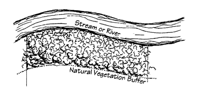
Stream buffers. Stream buffers are established in article 8 of this UDC. Article 5 of this UDC establishes environmental overlay districts which require river and stream buffers.
(Ord. No. 22-010, § 1, 8-15-2022)
Sec. 1202. - Definitions.
The definitions of this section shall apply to all divisions of this article.
ANSI A300 Standards: The generally accepted (consensus) industry standards for tree care practices by the Tree Care Industry Association (TCIA) and written by a committee called the Accredited Standards Committee ASC A300. These standards are based on current research and sound practice for writing specifications for planting, managing, and caring for trees, shrubs, and other woody plants.
Arborist: A professional certified by the International Society of Arboriculture (ISA) who possesses the technical competence through experience and related training to provide for, or supervise, the planting, management, and care of trees and other woody plants in the residential, commercial, and public landscape. In the absence of an appointed arborist the public development department or their designee shall serve as the arborist for the county.
Berm: An earthen mound or embankment, usually less than three feet if designed to provide visual interest only, and usually six feet more in height if intended to screen views or reduce noise.
Caliper: The trunk diameter of a tree (usually nursery stock) six inches or top of the rootball for up to and including four-inch diameter trees and 12 inches above the ground or top of rootball for larger trees.
Critical root zone (CRZ): The minimum area beneath an existing tree that must be left undisturbed in order to preserve a root zone sufficient to give a tree a reasonable chance of survival. The CRZ will typically be represented by a concentric circle centered on the tree's trunk in a radius a radius equal in feet to 1.25 times the number of inches of trunk diameter measured at four and one-half feet (DBH) above ground level or to the edge of the tree canopy dripline, whichever is greater. Example: The CRZ radius of a 20-inch diameter tree is 20 x 1.50 = 30 feet from the center of the base of the tree.
Crown: The leaves and branches of a tree or shrub; the upper portion of a tree from the lowest branch on the trunk to the top.
Deciduous: A perennial plant with foliage (leaves) that becomes dormant, typically in the fall, and totally or partially casts off leaves annually, depending on species.
Diameter breast height (DBH): The standard measure of trunk diameter for those trees existing on a site. The diameter of a tree with diameter is measured in inches at a height of 4.5 feet above the ground. If the tree splits into multiple trunks below 4.5 feet, the trunk is measured at its most narrow point beneath the split. Trees with foliage that is full to the ground are typically measured based on height (e.g., magnolia).
Drip line: The drip line of the tree is the imaginary perpendicular line on the ground that mimics the outer edge of a tree's canopy and is a circular area of the land surrounding the tree from the trunk to the outermost branches. This area is distinguished from, and not to be confused with, the critical root zone.
Evergreen: Evergreen trees retain most of their foliage that persists and remains green year-round.
Ground cover: Living, low growing plant material, other than turf grass, which forms a continuous 80 percent or more cover over the ground surface at the time of planting and that can be maintained at a height of not more than 18-inches.
Hardwood tree: This term refers to trees belonging to a botanical group with broad leafed foliage, versus needle-like foliage and typically go dormant in the winter. "Hardwood" mainly refers to leaf shape and not to hardness of the wood itself.
Landscape plan: A graphic and written document containing criteria, specifications, and detailed plans prepared by a registered landscape architect. A landscape plan consists of a site map showing the boundaries of the property and the location of proposed plant materials (trees, shrubs, and others) in relation to surroundings and improvements, along with the planting schedule and any additional specifications to be required by the public development department.
Landscaped open space: That portion of a given lot, not covered by buildings, parking, access and service areas, or detention ponds. This is designed to enhance privacy and the amenity of the development by providing open spaces and/or landscaping features, screening and buffering for the benefit of the occupants or those in neighboring areas, or a general appearance of openness. Landscaped open space areas may include but not be limited to, individual trees, existing wooded areas, water courses, grass lawns, decorative plantings, berms, walls, fences, walkways, ornamental objects such as fountains, statues, and other similar items all of which are designed and arranged to produce an aesthetically pleasing effect within the development.
Landscape strip: A planted area of specified width.
Landscaping: The modification of the landscape for an aesthetic or functional purpose. The area within the boundaries of an individual lot that includes the preservation of existing vegetation and the continued maintenance thereof, as well as, the installation of trees, shrubs, ground covers, grass and flowers. Landscaping areas may also be subject to the zoning administrator's approval including decorative rock, bark, mulch, and other similar materials in addition to vegetation and live plant material.
Mulch: Organic matter composed of pine straw, leaves or aged wood chips. Compost, pine bark, or a combination thereof, that is applied in a layer on the ground over the roots of a tree to retain soil moisture, improve soil texture, cover and suppress the unwanted growth of vegetation, increase soil nutrients, and provide a favorable habitat for beneficial soil organisms.
Opaque: Impenetrable to view
Parking screen: A continuous hedge of evergreen shrubs attaining a height of at least three feet above grade.
Qualified professional: An ISA certified arborist, forester, registered landscape architect, county extension agent, technical staff of the Georgia Forestry Commission, or other professional accepted by the public development department as having the requisite qualifications as a professional regarding trees and landscaping and the preparation of plans. For purposes of preparing existing tree canopy calculations, a registered land surveyor or registered engineer shall be considered a qualified professional.
Replacement tree: A tree planted on a site to meet a required minimum site canopy percentage. This canopy requirement must be met or exceeded.
Required minimum site canopy percentage factor: A minimum canopy percentage based upon the requirements of the zoning district regardless of whether the site had sufficient tree canopy prior to development. For these sites, the canopy percentage may be achieved by retaining existing canopy to be preserved, planting new trees, or a combination of the two.
Screening: An opaque constructed or vegetative (preferred) visual screen with a height of at least six feet.
Shrub: A self-supporting, woody, perennial deciduous or evergreen woody plant that normally reaches a mature height of less than 15 feet and typically has multiple stems.
Structural buffer: A visual screen created through construction of a solid wooden fence, decorative masonry wall, earthen berm, or combination of fence or wall with an earthen berm. Such structures may be supplemented with vegetation so as to present an opaque visual separation when viewed from one side to the other throughout the year.
Tree: Any self-supporting, woody perennial plant, evergreen or deciduous, usually having a single trunk diameter of at least two inches, as well as many branches, and which normally attains a mature height of at least ten feet.
Tree canopy: The total area beneath the drip line of a qualifying tree
Tree, large canopy: A tree species with a canopy that typically covers at least 1,600 square feet at maturity under urban conditions, with a crown diameter of at least 45 feet at maturity and makes up the uppermost layer of tree canopy. Also known as an overstory tree.
Tree, medium canopy: A tree species with a canopy that typically covers at least 900 square feet at maturity but less than 1600 square feet under urban conditions, with a crown diameter of at least 35 feet at maturity.
Tree, small canopy: A tree species with a canopy that typically covers at least 400 square feet at maturity but less than 900 square feet under urban conditions, with a crown diameter of at least 25 feet at maturity.
Tree canopy coverage: The total area of a development site or building lot with actual existing tree coverage which is measured in square feet. This coverage may, in some locations, include coverage provided by abutting properties even though the tree trunk is not located on the development site or building lot. The total coverage is to be reported as a percentage of required coverage, which, if less than the required coverage, must be augmented by additional tree planting to meet this percentage.
Tree protection area: A defined area surrounding and protecting existing trees and their root systems, as well as protecting natural buffers and, at the minimum, includes the critical root zone as well as the above ground portion of these trees.
Turf: Ground cover composed of one or more species of perennial grass grown in soil to form a permanent lawn.
Xeriscaping: Landscape design that uses low-water use or drought tolerant plants requiring little to no supplemental irrigation and may include the use of few or no plants.
(Ord. No. 22-010, § 1, 8-15-2022)
Sec. 1203. - Zoning buffer requirements.
(a)
When required. Zoning buffers are required to be provided at the time of construction of any new development, subject to the requirements of this article.
(b)
Disturbance. Zoning buffers required by this division shall remain undisturbed, except where necessary to add vegetation to meet screening requirements, unless encroachments or grading are specifically authorized by this division. Unless encroachments or grading are specifically authorized, or unless a variance is granted by the board of adjustment in accordance with this UDC, existing trees within a buffer required by this UDC shall not be removed.
(c)
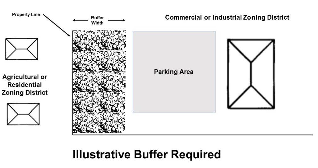
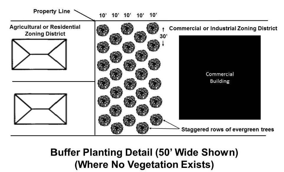
Minimum required screening. Required buffers shall provide screening, as defined, with a natural buffer of existing vegetation. Where the full width of the required buffer does not exist or where existing vegetation is sparse such that it does not meet the screening standard, the buffer shall be replanted at the required minimum width. Natural buffers may contain deciduous vegetation but shall contain evergreen trees suitable to local growing conditions that will provide an opaque visual screen during all seasons of the year. Unless existing vegetation provides the required screening or another alternative that meets the requirements for opaque visual screening is approved by the public development department, one evergreen tree, with a minimum height of six feet at planting, with branches touching the ground shall be planted for each 30 feet of buffer length, for each ten feet of required buffer width. Rows of evergreen trees shall be staggered. Evergreen screening shrubs planted four feet on center should also be used where necessary to provide the required screening.
(d)
Relocation. Zoning buffers may be relocated on the site to best achieve the screening required.
(e)
Buffer encroachments. Zoning buffers shall contain no driveways, parking areas, patios, stormwater detention facilities, or any other structures or accessory uses except that underground utilities may be permitted to cross a buffer if the screening standards of this UDC will be subsequently achieved. Buffers required by this article (excludes stream buffers) may include structural buffers as specified in this division.
(f)
Disturbance or grading in buffers. Disturbance or grading within a zoning buffer may be authorized by the public development director in certain limited instances:
1.
Where existing topography is such that a berm or other change in elevation within the zoning buffer would be more effective in meeting the screening requirements of this section, in which case grading may be authorized;
2.
Where existing vegetation is of limited screening value, in which case clearing and grubbing may be permitted;
3.
When a structural buffer is authorized; and
4.
In cases where a zoning buffer is authorized to be relocated, clearing, grubbing, and grading may be authorized in the original area of the zoning buffer.
(g)
Maintenance. Every buffer required by this article shall be maintained by the owner of the property where the buffer is located, so as to provide an opaque visual screen to a height of at least six feet on a continuous, year-round basis.
(h)
Shown on plans. All required buffers shall be shown on grading and landscaping plans.
(Ord. No. 22-010, § 1, 8-15-2022)
Sec. 1204. - Structural buffer.
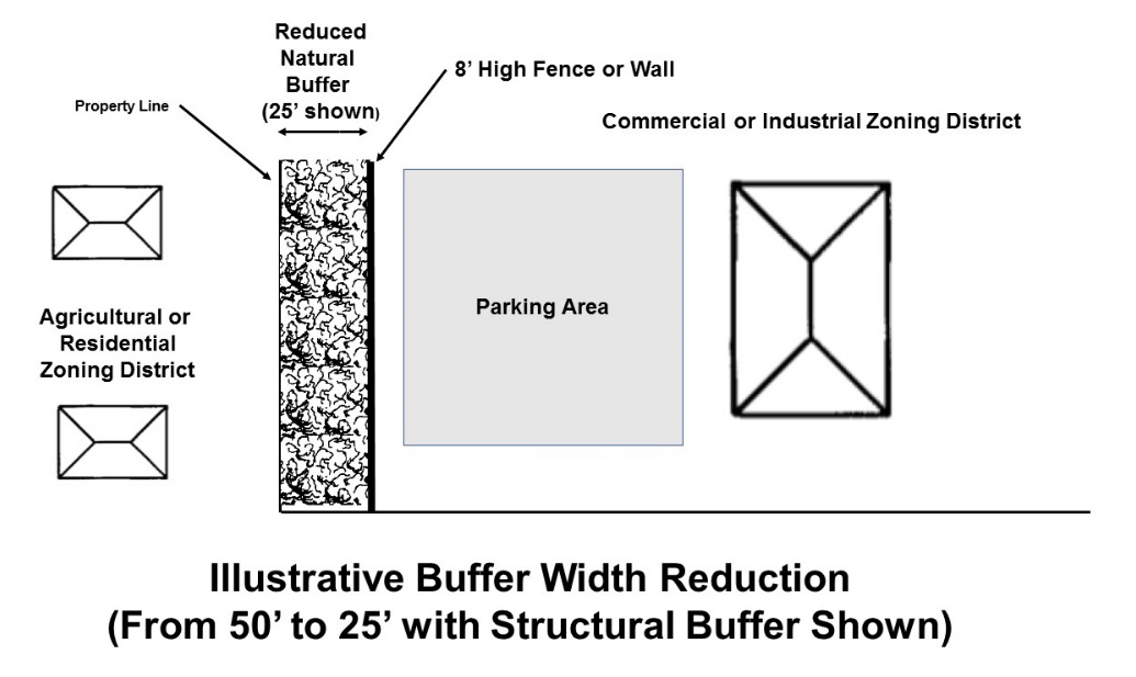
The minimum required width of a natural buffer required by this article (excludes stream buffers) may be reduced by as much as 50 percent if a structural buffer is installed along the entire buffer length where a reduction of width is sought, in accordance with the requirements of this section.
(a)
Minimum required height. A structural buffer shall provide an opaque screen to a height of no less than eight feet.
(b)
Slope of berm. If a berm is utilized as a structural buffer, it shall have a maximum side slope of 50 percent (i.e., one foot of vertical rise to two feet of horizontal run).
(c)
Planting. Within the reduced natural vegetative buffer area, where no vegetation exists or where sparsely vegetated, at least two staggered rows of evergreen trees with branches touching the ground shall be required for each 25 feet of vegetated buffer width.
(d)
Materials. Fences used in buffers must be constructed of cedar, redwood, treated wood, or other approved material. Walls used in buffers shall be masonry. Fences and freestanding walls shall present a finished appearance facing the abutting property.
(e)
Setback. Fences or walls within required buffers shall be located interior to the natural vegetative buffer.
(f)
Maintenance. Every structural buffer installed per the requirements of this section shall be maintained by the owner of the property where the structural buffer is located, so as to provide an opaque visual screen to a height of at least eight feet.
(Ord. No. 22-010, § 1, 8-15-2022)
Sec. 1211. - Findings, purpose, and intent.
(a)
Trees improve air and water quality, reduce soil erosion, reduce noise and glare, provide habitat for wildlife, moderate the climate, and enhance community image and property values. Therefore, it is the intent of this article to encourage the protection and provision of trees through sound, responsible land development practices.
(b)
Landscaping enhances a community's environmental and visual character and improves the overall quality of life. Vegetation can also improve air and water quality, reduce soil erosion, reduce noise and glare, provide habitat for wildlife, moderate the climate, and enhance property, thus protecting the health, safety, and welfare of the community.
(c)
It is the purpose of this article to provide trees, environmentally sound landscape amenities, and buffers which promote a positive community image by promoting quality development, enhancing property values, providing for landscape improvements, and promoting aesthetic quality. It is also the intent to promote a healthy, natural environment whenever possible by protecting and enhancing existing vegetation.
(d)
Inappropriate landscaping can degrade the quality of the natural environment by requiring excess water and pesticides, or by creating unnecessary conflicts with sewers, sidewalks, and vehicle access. It is important to promote environmentally sound landscaping, including the use of low-maintenance, drought resistant, and native or noninvasive plants, and to ensure that the right tree is planted in the right place. Environmentally sound landscaping also means restricting the use of invasive and potentially invasive species. Although well-mannered nonnative species can be welcomed additions to a landscape, invasive species can cause severe economic and environmental harm (including crop damage and degradation of native habitats) and can engender significant control costs.
(e)
This article also establishes standards for buffers and landscape strips. Buffers between two incompatible uses minimize harmful impacts such as transmission of noise, dust, and glare. Buffers can also lessen visual pollution, establish a greater sense of privacy or physical intrusion, and protect the public health, safety, and welfare of the community.
(Ord. No. 22-010, § 1, 8-15-2022)
Sec. 1212. - Tree protection required.
Tree protection requirements of this article shall be applied to every activity that requires the issuance of a land-disturbance permit or development permit under this UDC, except for other activities otherwise exempted by this chapter.
(Ord. No. 22-010, § 1, 8-15-2022)
Sec. 1213. - Designation of tree protection areas.
The following areas shall be designated as tree protection areas on grading plans, landscaping plans, and final plats, within which it shall be unlawful to remove trees unless specifically provided by this section.
(a)
Stream buffers. Stream and any other riparian buffers required by state law or this UCD.
(b)
Zoning buffers. Natural buffers when required by zoning district: Every required zoning buffer shall be maintained by the owner of the property where the buffer is located, so as to provide an opaque visual screen to a height of six feet on a continuous, year-round basis.
(c)
Existing trees to be retained. Where a developer or subdivider proposes or is required to retain trees outside of required stream buffers and zoning buffers.
(Ord. No. 22-010, § 1, 8-15-2022)
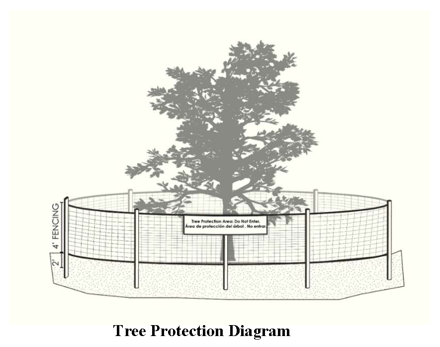
Sec. 1214. - Tree protection fencing to be required.
(a)
Tree protection areas shall be actively protected during land disturbance and land development with tree protection fencing (see following figure), installed at the boundaries of all tree protection areas. An inspection by the public development department (or their designee) is required of all installed tree protection prior to commencement of any land development or land disturbance activity.
(b)
Tree fencing shall be a minimum of four feet in height and comprised on chain link fencing, orange laminated plastic fencing supported by posts, wooden post and rail fencing, or other equivalent barrier.
(c)
The perimeter of the tree protection fencing shall be a radius of 1.5 feet for each inch of diameter.
(d)
Tree protection is required by this section until land development and construction activities cease, or a certificate of occupancy is issued, or authorization by the public development department is given to remove tree protection fencing, whichever is later.
(Ord. No. 22-010, § 1, 8-15-2022)
Sec. 1215. - Tree protection area signs required.
(a)
Prior to any land development or land disturbance activity, tree protection signs shall be installed on or along tree protection all trees to be retained and along the perimeter of all tree save areas at a minimum of every 200 feet and shall include the following text: "Tree Protection Area. Do Not Enter" in both English and Spanish.
(b)
The signs shall be fabricated of sturdy material, shall be a minimum of 18 inches by 24 inches, and shall be placed on a sturdy post with the bottom of the sign a minimum height of 30 inches above grade. The signs must remain present at all times during land development and building construction.
(Ord. No. 22-010, § 1, 8-15-2022)
Sec. 1216. - Prohibitions within tree protection areas.
(a)
When a tree protection area is established and delineated on a recorded subdivision plat, or an approved land development plan, any and all trees within the tree save area delineated on the plan or land development plan shall be preserved by the subdivider and subsequent lot owner except as otherwise exempted or specifically authorized in this chapter.
(b)
Except as specifically authorized in this chapter, tree protection areas shall remain in a natural, undisturbed condition; activities related to development with a tree protection area shall be prohibited. These specifically includes prohibition of the following:
1.
Vehicle or equipment traffic or storage.
2.
Materials or supplies storage.
3.
Placement of temporary or permanent structures.
4.
Equipment maintenance or washout.
5.
Wounding of tree trunks, or wounding or breakage of limbs or branches greater than four inches in diameter, topping or other improper pruning, such as stub cuts or flush cuts.
6.
Fires or excessive heat from equipment exhausts.
7.
Site or lot clearing or grubbing, soil excavation or soil cuts or fills, grading, trenching, tilling, soil compaction, top dressing with fill or soil greater than two inches in depth and paving.
(Ord. No. 22-010, § 1, 8-15-2022)
Sec. 1217. - Damage to tree protection areas.
Any land disturbance within a tree protection area shall be cause for an issuance of a stop work order unless such disturbance is authorized by the public development department. Any tree within a tree protection area that is damaged during land disturbance, land development, or building or site construction shall be treated according to ANSI A300 standards.
(Ord. No. 22-010, § 1, 8-15-2022)
Sec. 1218. - Replacement of damaged trees.
The property owner or his or her assigns shall replace any tree (required to be retained or that is planted in conformance with requirements of this article) that dies or is removed from a site, if such removal results in a tree canopy coverage less than that required by this article, or any other deficiency with regard to meeting the requirements of this article. Replacement is required by the next planting season with a tree of same or similar species and projected canopy size at maturity as determined by public development department.
(Ord. No. 22-010, § 1, 8-15-2022)
Sec. 1219. - Protection of trees on public property.
(a)
No person shall plant, spray, fertilize, prune, or remove, or otherwise disturb any tree on any road right-of-way or property owned by the county without first securing permission from the county. No person shall cause damage to trees on rights-of-way or other public property by cutting, carving, attaching any rope, wires, nails, signs, or other object to any such tree, or allowing any harmful gas, liquid, or solid substance to contact any tree, or to set fire or permit any fire to burn which may injure any portion of any tree, or causing harm to tree roots through construction activities, vehicle parking, or material storage.
(b)
It shall be unlawful for any person or firm to top or severely prune any street tree, park tree, or other tree on public property. Topping is defined as the severe cutting back of limbs to stubs larger than three inches in diameter within the tree's crown to such a degree so as to remove the normal canopy and disfigure the tree. Severe pruning seriously affects a tree's food supply, can scald the newly exposed outer bark, make trees vulnerable to insect invasion, stimulates the re-growth of dense, upright branches below the pruning cut, make the tree more vulnerable to wind damage, disfigures the tree aesthetically, and sometimes results in the death of the tree. Where appropriate, crown reduction pruning according to ANSI standards by a qualified arborist may be substituted. Trees severely damaged by storms or other causes, or certain trees under obstructions such as utility wires where other pruning practices are impractical may be exempted from this section as determined by the public development department.
(Ord. No. 22-010, § 1, 8-15-2022)
Sec. 1231. - Determination of existing tree canopy coverage.
(a)
Generally. Prior to engaging in land disturbance or land development, it shall be the duty of land developers to calculate existing tree canopy on any site to be disturbed or developed.
(b)
Sites with trees. The extent of tree canopy coverage can and shall be estimated based on a current or reasonable current (i.e., not more than three years from the date an application for land disturbance or land development is submitted) aerial photograph of the site, or calculation through i-Tree software. A copy of the aerial photograph utilized, or the i-Tree report, shall be provided as part of the application for land and disturbance or land development. Estimates of tree canopy coverage should be verified in the field by the applicant (with date of field verification so noted in the application) and subject to verification in the field by the county.
(c)
Sites without trees. Where no tree canopy exists on the site to be subdivided, disturbed, or developed, the applicant shall indicate such in the application for land disturbance or land development. Trees will have to be planted to meet the requirements of this article.
(Ord. No. 22-010, § 1, 8-15-2022)
Sec. 1232. - Existing canopy to be retained.
Where a development site or lot has existing tree canopy, the developer or subdivider shall propose all or some of the existing trees to be retained and designated as tree protection areas. The following provisions will apply to designation of tree protection areas for purposes of meeting the tree canopy requirements of this chapter.
(a)
Existing tree canopy on the parcel of land to be subdivided, disturbed or developed should be retained to the maximum extent possible. Land developers and subdividers will be required to consider designing land development in a way that protects existing trees to the maximum extent possible, while allowing for reasonable development of the site. This criterion applies even if the site can sustain significant tree removal and still meet minimum tree canopy coverage requirements of this article after such tree canopy removal.
(b)
Trees that conflict with the building envelope, that are within areas that must be cleared for parking and loading spaces, or in other places on the site where infrastructure must be installed, are to be approved for removal unless an alternate site design is considered feasible and the trees within such area are of high value as determined by the public development department or qualified professional.
(c)
If tree canopy must be, and is authorized to be removed from the site, healthy, native, hardwood trees that are 24 inches diameter breast height (DBH) or more, such trees retained and protected per this article shall be given 1.5 times the future tree canopy listed in the, and significant stands of trees, are the highest priority for retention.
(d)
To incentivize retention of trees that are 24 inches DBH or more, such trees retained and protected per this chapter shall be given 1.5 times the future tree canopy listed in the approved landscape planting list, or 1.5 times the actual tree canopy, whichever is greater. In such cases, the area of the tree canopy for which credit is given shall always remain in the tree canopy and there shall be no other use of the area other than for tree growth. The area shall remain permeable and undeveloped. Pine tree canopy shall be considered a lower priority for preservation.
(Ord. No. 22-010, § 1, 8-15-2022)
Sec. 1233. - Minimum tree canopy coverage requirements by land use.
(a)
Minimum ratios. All subdivisions and land developments shall meet the minimum tree canopy coverage requirements for the land use as indicated in table 12-1.
Table 12-1.
Minimum Tree Canopy Coverage Requirements by Land Use
Note 1: The total site area included within a major residential subdivision shall be required to meet the requirements of this section at the time of preliminary platting, also individual lots within a major or minor subdivision shall be subject to the minimum tree canopy requirements of this section.
(a)
Exemption for lakes and ponds: The area within natural or manmade bodies of water of two or more acres may be subtracted from calculations of tree canopy required.
(b)
Determination, uncertainty, and interpretation: With respect to classifying a land use for purposes of this section, the public development department shall determine the land use as that use which is the principal use of the development site or lot. The public development department shall be authorized to interpret the land use classifications in cases on uncertainty.
(c)
Compliance: A major subdivision or land development may meet the minimum tree canopy coverage requirements of this section by virtue of the tree canopy existing and to be retained on site. In this case, additional tree canopy coverage is encouraged but not required to be provided. Development sites and major subdivisions which have existing trees which result in a tree canopy coverage that meets or exceeds the requirements of this section will not be required to plant additional trees, except as may be required to meet parking lot landscaping, landscape strip, street tree planting, and/or buffer requirements of this land use management code. If a site does not have sufficient existing tree canopy, plans for the major subdivision or land development shall indicate additional tree planting in a manner that will meet the minimum requirements of this section.
(d)
Timing of compliance: Compliance with the requirements of this article will be determined at the time of development plan review (including review of tree protection areas and a landscaping plan proposing tree canopy) for a land development and at the time of preliminary plat review for a major subdivision.
(e)
Canopy cover credit for individual trees: For the purposes of this article, the tree canopy cover that is credited to an individual tree shall be either the actual square foot area of the crown's projection directly down onto the ground, or the tree canopy coverage at maturity as specified for the species listed in the approved landscape planting list, whichever is greater. Any tree of a species not on the approved tree species list must be approved for use by the public development director or their designee, and tree canopy credit at maturity will be determined using standard landscaping reference for the size typical of the species.
(Ord. No. 22-010, § 1, 8-15-2022)
Sec. 1234. - Addition of trees to meet minimum tree canopy coverage requirements.
(a)
When required: When a development site or major subdivision does not meet the minimum tree canopy coverage required via the maintenance of existing trees on site at the time of development or major subdivision, respectively, the developer or subdivider shall be required to plant trees on the development site or in the major subdivision's boundaries sufficient to meet the requirements of table 12-1.
(b)
When requirements cannot be met: When tree canopy requirements of this article cannot be met due to site conditions or hardship (such as rock or other existing naturally occurring environmental constraints) a certified arborist shall be employed by Jackson County to make an assessment of the site conditions and the required tree planting limitations, if any.
(c)
For purposes of calculating canopy at maturity, the approved tree species list canopy credit calculations are as follows:
a.
Large canopy trees: 1600 square feet per tree;
b.
Medium canopy trees: 900 square feet per tree;
c.
Small canopy trees: 400 square feet per tree.
(d)
Locations: Trees may be planted throughout the development site or lot, although preference should be given to parking lot, and the front yard of the property.
(e)
Species selection standards: Species shall be selected that are tolerant of growing conditions on the site, including growing space, sunlight, soil moisture, temperature, and soil volume and conditions. No more than 25 percent of all trees planted on a lot shall be of any one species.
(f)
Pine tree limitation: Where trees must be added to achieve the required tree canopy coverage requirement for the development site or lot, pine trees shall not compromise more than 25 percent of the tree canopy planted.
(Ord. No. 22-010, § 1, 8-15-2022)
Sec. 1250. - General provisions.
(a)
Native plants: The use of native plants is encouraged.
(b)
Invasive species: Invasive or potentially invasive plants are prohibited.
(c)
Xeriscaping and water conservation: Xeriscaping is encouraged. Ground covers should be used to supplement landscaping in appropriate areas to reduce extensive grass lawns that require regular watering in drought conditions.
(d)
Trees: Trees selected for planting must be free from injury, pests, disease, nutritional disorders or root defects, and must be of good vigor in order to assure a reasonable expectation of survivability.
(e)
Diversity: No more than 25 percent of trees or shrubs planted on any given site shall consist of any one species.
(f)
Grass: Grass lawn areas should be sodded. However, if grass seed must be used, it shall be a variety suitable to the area that produces complete coverage.
(g)
Artificial landscaping: No artificial plants, trees or other vegetation shall be installed.
(h)
ANSI 300 standards: Landscaping shall meet the requirements of ANSI 300 unless otherwise approved by the public development department.
(i)
Curb stops: A curb or wheel stop shall be provided along interior parking lot landscape islands, perimeter landscape strips, and landscapes adjacent to street rights-of-way, to prevent cars from encroaching on trees, shrubs, and landscapes, as approved by the public development department.
Tree Protection and Landscape Plan Required:
A tree protection and landscaping plan, titled as such, which shall be graphically depicted at an engineering scale, shall be required to be approved by the public development department prior to the issuance of a development or building permit to demonstrate compliance with the provisions of this article. A building permit may be withheld if such plan has not been submitted and approved. The tree protection and landscape plan shall be based on an accurate boundary survey of the site. This plan must be developed by, and stamped by, a registered landscape architect.
(a)
Existing trees to be retained: The extent, location, and existing individual trees on the development site or building lot that are proposed to be retained are to be noted on the plan, with tree protection zone illustrated. If existing individual trees are to be retained in order to meet canopy requirements, hardwood trees with a DBH of 24 inches or greater will qualify for 1.5 times their existing canopy credit (e.g. a large canopy tree is allotted credit of 1600 square feet; a 24 inch + DBH tree will be given credit for 2400 square feet). Existing vegetation to be retained must also be noted on the plan.
(b)
Trees not on approved landscape planting list: Generally, all proposed replacement trees must comply with the approved landscape planting list. Trees not shown on the approved landscape planting list must receive approval from the public development department.
(c)
Tree canopy: A spatial delineation of tree canopy coverage on site and a calculation of the existing tree canopy coverage as a percentage of the total development site area or lot.
(d)
Tree protection: Location and specifications of tree protection fencing, which shall be installed along all limits of disturbance (this must be shown on the grading plan as well). The plan shall incorporate verbatim in their entirety the following sections of this article. Additional methods and details for protecting existing vegetation during construction may be required.
1.
Obstructions to sight visibility.
2.
Inspections.
3.
Tree protection fencing required.
4.
Tree protection area signs required.
5.
Prohibitions within tree protection areas.
6.
Damage to tree protection areas.
7.
Tree replacement.
8.
Tree planting standards.
9.
Utility locations.
(a)
Graphic plan and schedule with legend: The extent, location and species of trees and shrubs to be planted on the development site or building lot to meet the requirements of this article. All information shall also be shown in a tree planting schedule and a separate planting schedule for shrubs that includes Latin names, species common names, symbol used on the graphic plan, caliper or size at time of planting, number of trees (or shrubs) by each species type and percentage of total trees planted for each species. The legend must show the label or symbol alongside each type of plant.
(b)
Other landscape features: Location and description of other landscape improvements, such as earth berms, walls, fences, screens, sculptures, fountains, street furniture, lights, and courts or paved areas.
(c)
Specifications: Other installation specifications and planting diagrams for trees and shrubs as appropriate or as supplied by the arborist or public development department.
(d)
Tree plan summary: The tree protection and landscape plan shall include the following summary:
a.
Existing tree canopy .....___ percent of total site area
b.
Existing tree canopy retained, if any .....___ percent of total site area
c.
Tree canopy required .....___ percent of total site area
d.
Tree canopy proposed/provided .....___ percent of total site area
e.
Tree canopy deficit, if any .....___ square feet
(e)
Plan preparer: Name, contact information, and signature/stamp of the professional preparing the tree protection and landscaping plan. The landscape plan shall be prepared by a registered landscape architect, however the public development department may authorize a landscaping plan applicable to a site of two acres or less to be prepared by another qualified professional.
(f)
Tree species and planting locations must conform to the approved landscape plan: Substitution of an alternate species or deviation regarding the plant spacings indicated on the plan must be approved in advance by the public development department or qualified professional.
(Ord. No. 22-010, § 1, 8-15-2022)
Sec. 1251. - Reference to requirements.
(a)
Minimum requirements:Article 2, table 2-2 establishes minimum tree canopy requirements for certain uses in certain zoning districts, and minimum front landscape strips for certain uses which vary by zoning district.
(b)
Special uses: The specific use requirements of article 3 may include requirements for landscape strips, depending on the particular use.
(c)
Overlay districts: Unique landscaping requirements apply to developments within the East and West Jackson Overlay Districts (see article 4 of this UDC) which supersede in certain instances the general requirements of this division; there is also a planting list for the East and West Jackson Overlay Districts.
(Ord. No. 22-010, § 1, 8-15-2022)
Sec. 1252. - Obstructions to sight visibility.
(a)
All landscaping and trees planted adjacent to street rights-of-way and driveway intersections with rights-of-way must be installed in a manner that maintains minimum vision clearances specified in this UDC.
(b)
No shrub or tree with heights of between two and one-half feet and 12 feet shall be located within 20 feet of the intersection of the right-of-way lines of streets, roads, highways or railroads, or within 20 feet of the intersection of a street right-of-way and either edge of a driveway.
(c)
No landscaping shall be allowed that obstructs or impairs the vision of any vehicle operator at the intersection of any public rights-of-way, at any entrance onto or exit from a public road, or any other location where said obstruction would create a hazard to life or property.
(d)
The county shall have the right, but not the obligation, to prune any tree or shrub on private property when it interferes with street light lighting effectiveness, or it interferes with visibility of a street sign or any traffic control device, or sight lines necessary for the public's safe vehicular travel or foot travel, or poses an imminent danger to the public.
(Ord. No. 22-010, § 1, 8-15-2022)
Sec. 1253. - Frontage landscape strip.
(a)
Width.
1.
Minimum width: The minimum width of a frontage landscape strip shall be as specified in table 2-2 of this UDC for the zoning district in which the development site is located, except as otherwise provided in this section.
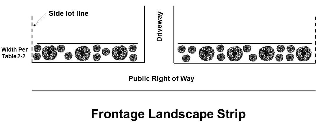
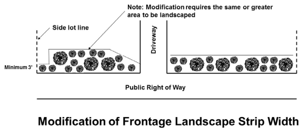
2.
Modification of width: The width of a minimum required frontage landscape strip shall typically be uniform across the frontage of the lot; provided, however, the public development department may authorize the width of a minimum required frontage landscape strip to be varied so long as the total area of the frontage landscape strip equals or exceeds the total area that would otherwise be required for the frontage landscape strip. In no event shall a required frontage landscape strip be reduced to less than three feet under the provisions of this paragraph.
3.
Natural vegetation in lieu of frontage landscape strip: The public development department may authorize the retention of existing natural vegetation in lieu of a required frontage landscape strip, if retaining existing landscaping would provide an equivalent number of trees and shrubs as required by this section.
(b)
Trees.
1.
Planting rate: For any frontage landscape strip required by this UDC, trees shall be maintained or planted at the rate of at least one tree unit for every 40 feet of length of street frontage, or portion thereof (excluding driveways), for each ten feet of required landscape strip width.
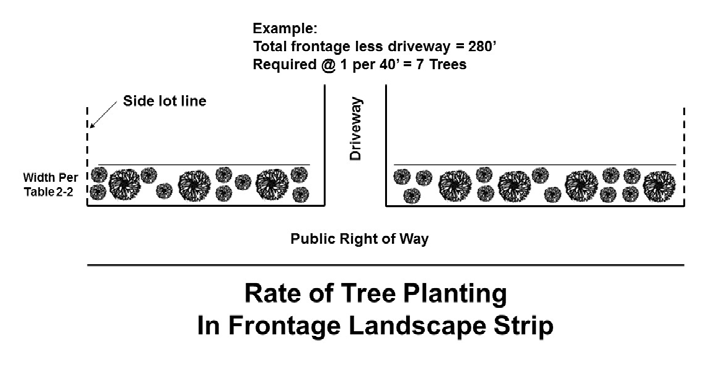
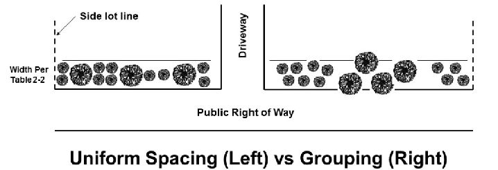
2.
Spacing and arrangement: Trees may be spaced in a uniform manner or they may be clustered for a more natural or decorative arrangement.
3.
Species: Such trees may be hardwoods or softwoods, but must be of a type that is suitable to local growing conditions.
4.
Minimum size: At the time of planting, trees within required front landscape strips shall have a minimum caliper of at least 2.5 inches.
5.
Credit toward minimum canopy requirements: Trees required to be planted within frontage landscape strips shall be credited toward meeting the minimum canopy requirements of this article for individual development sites. A required front landscape strip shall be the priority location for the planting of trees as may be required to comply with the canopy requirements of this article.
(c)
Shrubs.
1.
Rate: Shrubs shall be installed within any required frontage landscape strip at the rate of at least ten shrubs for every 40 feet of length of street frontage, or portion thereof (excluding driveways), for each ten feet of required landscape strip width.
2.
Minimum size: Shrubs installed within any required frontage landscape strip must be at least 18 inches in height at the time of planting and must be capable of reaching a height of at least two feet at maturity.
(d)
Authorized accessory uses within front landscape strips. The following uses are authorized within frontage landscape strips:
1.
Driveways and sidewalks: Driveways and sidewalks may be located within a required frontage landscape strip to the extent needed to cross the landscape strip.
2.
Walls: Retaining walls, and walls or fences authorized by the director of public development for screening or aesthetic effect, may be located in a required frontage landscape strip.
3.
Signage: If permitted by article 7 of this UDC, a ground sign may be located within a required frontage landscape strip.
4.
Utilities: Underground utilities may cross a required frontage landscape strip. Fire hydrants shall also be authorized to be located within a required frontage landscape strip.
5.
Stormwater: Detention ponds shall not be authorized within required frontage landscape strips. However, a land development project that incorporates low impact development principles consistent with the Georgia Stormwater Management Manual (e.g., vegetative swale) may be authorized by the public development director, consistent with the requirements of article 11 of this UDC. Stormwater best management practices (BMPs) may be applied or incorporated within front landscaping strips, and a front landscaping strip may if appropriate be accepted as a BMP.
(e)
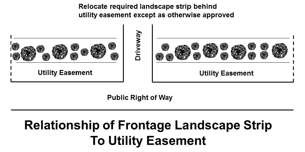
Relationship to utility easements. Where a development site has an existing or proposed utility easement abutting and running parallel or approximately parallel to the right-of-way in the same location as a minimum required frontage landscape strip, the landscape strip shall be relocated interior to the utility easement that abuts and parallels or approximately parallels the right-of-way; provided, however, the public development department may authorize part of the minimum frontage landscape strip be located within the utility easement only if the utility easement owner authorizes the planting of trees and shrubs within the utility easement.
(Ord. No. 22-010, § 1, 8-15-2022)
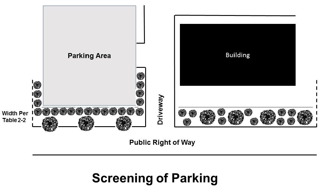
Sec. 1254. - Side lot line landscape strips.
(a)
Landscape strips alongside lot lines are not required; provided, however, that where screening of a parking lot is required, a side landscape strip may be required.
(b)
If this UDC requires a side landscape strip for a particular use, it shall be planted to the standards for a front landscape strip as required by this UDC.
(Ord. No. 22-010, § 1, 8-15-2022)
Sec. 1255. - Parking lot landscaping.
(a)
Applicability: This section shall apply to parking lots with ten or more car parking spaces.
(b)
Planting island: One parking lot tree for each ten car parking spaces is required and shall be installed. No more than ten contiguous car parking spaces shall be allowed without a minimum of one landscape island or peninsula containing one or more trees.
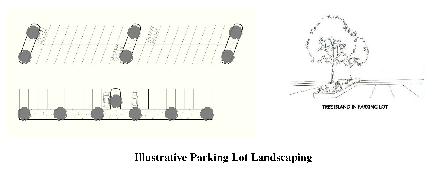
(c)
Minimum dimensions of islands: A landscape island within a parking lot shall have a minimum width of nine feet and minimum depth of 16 feet measured from interior face of curb to interior face of curb; however, wider (12 or more feet) landscaping islands are strongly encouraged and may be required to provide sufficient growing area for certain canopy tree species selected.
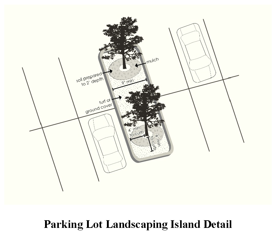
(d)
Minimum planting: Each landscape island shall contain a minimum of one tree having a minimum caliper of two inches at the time of planting.
(e)
Relation to canopy requirement: Trees planted within parking lot landscaping islands and existing trees if located within a parking lot and retained, shall count toward meeting minimum canopy requirements of this article.
(f)
Parking screen: If the land development includes car parking within a front yard, the shrubs must be arranged to provide a continuous visual screen to a height of three feet above grade between the front right-of-way and the parking lot. If the land development includes parking within a side yard, the shrubs must be arranged to provide a visual screen along the front right-of-way and that portion of the side yard parking lot. Where parking spaces within a front yard are visible from the front public right-of-way even with the frontage landscape strip, the continuous visual screen required by this subsection shall be extended along the side lot line for the length of the parking area that is visible from front public right-of-way. Parking lot screening may require the planting of shrubs at a higher rate than is otherwise be required by this subsection.
(Ord. No. 22-010, § 1, 8-15-2022)
Sec. 1256. - Approval of plant materials.
(a)
Approved plant species: The public development director is authorized to promulgate and publish and amend from time to time a list of approved plant species. See section 448 of this UDC for species approved for planting within the East and West Jackson Overlay Districts.
(b)
Department approval: Specific landscaping, trees, and buffer material are subject to the approval of the public development department.
(c)
Flowering ornamental species: Flowering ornamental species are typically not acceptable for use in meeting the tree canopy requirements of this article.
(d)
Pine trees: Where trees must be added to achieve the required tree units per acre for the site, pines may not comprise more than 25 percent of the required units. Where existing pines already comprise 25 percent or more of the required units, no more pines may be credited toward meeting the minimum required number of tree density units.
(e)
Replacement tree diversity: Species selected as replacement trees must be quality specimens, and must be ecologically compatible with the intended growing site. To ensure diversity, a minimum of four species of tree shall be used. Sites requiring limited replacement shall be evaluated by the public development department and may be allowed to use fewer than four species.
(Ord. No. 22-010, § 1, 8-15-2022)
Sec. 1257. - Plans.
(a)
For any land disturbance, land development, or building subject to the requirements of this article, buffer, tree protection and landscaping plans are required to be submitted with any application for a land disturbance permit, development permit, tertiary land disturbance permit, or for a building permit for new construction of buildings. See article 8 of this UDC for plan submission requirements.
(b)
The provisions of this section shall not apply to structures for which buffer, tree protection and landscaping plans have previously been submitted and approved for the subject site.
(c)
Buffer, tree protection and landscaping plans shall be required for only that phase of development for which the land-disturbance permit, tertiary land-disturbance permit, development permit or building permit is being requested.
(Ord. No. 22-010, § 1, 8-15-2022)
Sec. 1258. - Contents of tree protection and landscaping plans.
Tree protection and landscaping plans shall meet the following minimum requirements:
(a)
A site plan with property boundaries, proposed buildings, parking areas, loading areas, required buffers, utility easements if any, and other pertinent information as may be required by the public development department. The site plan shall show the location of all trees, shrubs, and landscaping.
(b)
A planting schedule for all trees, shrubs, and ground covers proposed, with scientific name and common names of each species, the total number of each species planted, and total numbers of trees. Trees and shrubs shall be indicated on the plan using symbols and the symbols must appear in the planting schedule.
(c)
Calculations demonstrating the plan meets minimum landscaped open space and minimum tree canopy requirements of this article.
(d)
A tree survey, if existing trees are proposed to be counted toward meeting the minimum tree canopy requirements of this article. Existing vegetation to be retained shall be shown on plans.
(e)
Standard details and notes with regard to planting instructions.
(Ord. No. 22-010, § 1, 8-15-2022)
Sec. 1259. - Tree planting standards:
(a)
Quality: Trees planted to satisfy the requirements of this article shall meet minimum quality standards as established in ANSI A300 standards, as officially revised from time to time.
(b)
Caliper and height: Trees shall be a minimum of two-and-one-half-inch caliper for deciduous trees, a minimum of eight feet in height for evergreen trees, and a minimum of one inch caliper per trunk for multi-stemmed trees at the time of planting.
(c)
Critical root zone protection: Grading, excavating, or locating utilities within the critical root zones of trees shall be prohibited. No activity or materials, including solvents, construction equipment, portable toilets, construction trailers or temporary soil deposits shall encroach or be placed within the critical root zone of any tree protected under the requirements of this article.
(d)
Soil depth: The soil within an area intended for tree planting shall be well aerated to a minimum depth of 12 inches; soils in tree planting islands surrounded by pavement shall be well aerated to a minimum depth of 18 inches.
(e)
Soil composition: The soil shall contain a minimum of five percent organic matter. Soil pH shall be within a range of 5.8 to 7.0.
(f)
Watering: Trees shall be "watered in" at the time of planting to eliminate air pockets.
(g)
Staking: Although tree staking is not generally required, it may at times be required under certain site or other conditions. If installed, stakes shall be removed by the tree owner no later than six months after planting. Any staking shall comply with ANSI A300 standards.
(h)
Mulching: Trees shall be mulched immediately, utilizing hardwood mulch, in accordance with the ANSI A300 standards as may be revised from time to time.
(i)
Additional technical standards: The public development department, with arborist recommendation, may establish additional technical specifications or standard drawings for planting trees to implement the intention of this article.
(Ord. No. 22-010, § 1, 8-15-2022)
Sec. 1260. - Maintenance of landscaping.
(a)
A financial surety for maintenance is required, for a two-year period and in an amount equal to 100 percent of the installation cost of landscaping and trees. The owner, tenant and their agent, if any, shall be jointly and severably responsible for the maintenance in good condition of the plant materials used to meet the minimum requirements of this article for buffers, tree replacement, and landscaping. This responsibility is in addition to and survives the release of any bond or financial surety provided for the land development by the developer.
(b)
Plants that are diseased, damaged beyond point of survival, or are dead shall be removed and replaced with a plant of the same species, variety or cultivator, as approved by the public development department.
(c)
All landscape materials shall be maintained and shall be kept clear of refuse and debris.
(Ord. No. 22-010, § 1, 8-15-2022)
Sec. 1261. - Inspections.
An inspection shall be made by the public development department, or their designee, of all landscape plantings to assure compliance with plan requirements prior to release of the development surety. The surety will be drawn upon by Jackson County if the planting requirements of this article have not been fulfilled.
(a)
Generally: Inspections shall be required to ensure that the purposes and provisions of this article are met.
(b)
Preliminary inspections: A development site or lot shall be inspected with the applicant or his/her agent prior to plan review for the purpose of identifying options for tree conservation and compliance with technical standards. The preliminary inspection may be used to confirm the accuracy of the tree canopy requirement.
(c)
Tree protection inspection: An onsite inspection shall be made prior to any land disturbance to ensure that all tree protection measures required have been installed and following land disturbance to ensure the required tree protection measures are being complied with.
(d)
Pre-installation: An inspection shall take place at the time of the delivery of the trees and shrubs on site, prior to their installation, to assure their quality and to review planting requirements.
(e)
Periodic inspections: Additional site inspections may occur periodically or at any time during development or construction or encroachment to ensure that all requirements of this article are being met.
(f)
Certificate of occupancy inspection: A site inspection shall be required prior to issuance of a certificate of occupancy for the purpose of ensuring that all applicable requirements of this article have been met.
(Ord. No. 22-010, § 1, 8-15-2022)
Sec. 1262. - Approved landscape planting list.
This list is a guide, and any substitutions must be approved by the public development department or their designee prior to plan approval and issuance of a development permit. Plants must be considered to be non-invasive.
Drought tolerance, or suitability for wet sites, has not been specified. Determination as to the plant's suitability to a particular condition will be evaluated by the public development department or their designee at the time of plan submission.
(Ord. No. 22-010, § 1, 8-15-2022)