Jackson County Unincorporated
City Zoning Code
City Zoning Code
ARTICLE 4
- OVERLAY DISTRICTS
Sec. 401. - Establishment.
There is hereby established the following overlay districts in unincorporated Jackson County:
Jackson County Airport Overlay District
East Jackson Corridor Overlay District
West Jackson Corridor Overlay District
(Ord. No. 17-003, § 1, 10-2-2017)
Sec. 402. - Boundaries and interpretation.
(a)
The boundaries of the overlay districts established in this article shall be shown on the official zoning map adopted per section 201 of this UDC, or via a separate map made a part of the official zoning map. Whether shown on the official zoning map or on a separate overlay district map or maps, overlay district boundaries are and shall be considered an integral part of the official zoning map.
(b)
If an overlay district regulation specifically describes the boundaries of an overlay district, then the specific description regarding that overlay district shall apply.
(c)
All applicable provisions regarding the official zoning map provided in article 2 of this UDC shall be considered applicable to overlay districts, including but not limited to, provisions regarding determination and interpretation of zoning district boundaries, as provided in section 204 and section 205 of this UDC respectively, which may be considered applicable by the public development director in the determination and interpretation of overlay district boundaries.
(Ord. No. 17-003, § 1, 10-2-2017)
Sec. 403. - Amendment of boundaries.
The boundaries of any overlay district may be amended from time to time, following the same requirements and procedures of this UDC for an amendment to the official zoning map to change an underlying zoning district.
(Ord. No. 17-003, § 1, 10-2-2017)
Sec. 404. - Relationship to underlying zoning district.
(a)
The requirements of any overlay district established by this article or in article 5 of this UDC are in addition to the regulations established for the zoning districts in which a given property is located.
(b)
In any case where the requirements of an overlay district conflict with requirements of an applicable zoning district or any other provision of this UDC, the requirements of the more restrictive section or provision shall apply.
(Ord. No. 17-003, § 1, 10-2-2017)
Sec. 411. - Findings, purpose and intent.
(a)
Findings. The Board of Commissioners of Jackson County finds that certain hazards to air navigation, as defined, in effect reduce the size of the area available for landing, takeoff, and maneuvering of aircraft, thus tending to destroy or impair the utility of Jackson County Airport and the public investment therein. The creation or establishment of a hazard to air navigation, as defined, is a public nuisance and may injure the region served by the Jackson County Airport. It is necessary in the interest of public health, public safety and general welfare that the creation or establishment of hazards to air navigation, as defined, be prevented. The prevention of hazards to air navigation, as defined, should be accomplished, to the extent legally possible, by the exercise of police power without compensation. It is also in the public interest to require the marking and lighting of existing hazards to air navigation, as defined.
(b)
Purpose. This division regulates and restricts the heights of constructed structures and objects of natural growth, creates appropriate airport zones, establishes the boundaries thereof and provides for changes in the restrictions and boundaries of such zones via a variance process, and creates a permitting process for uses within said airport zones.
(c)
Intentions. It is the intent of the board of commissioners to protect the airspace above and around Jackson County Airport from objects that pose an obstruction or hazard to air navigation at Jackson County Airport. This overlay district is intended to be established to meet the requirements of United States Code of Federal Regulations, title 14: Aeronautics and Space, chapter I—Federal Aviation Administration, Department of Transportation, subchapter E—Airspace, part 77—Safe, Efficient Use, and Preservation of the Navigable Airspace (hereafter, "Part 77"), including but not limited to subpart C—Standards for Determining Obstructions to Air Navigation.
(Ord. No. 17-003, § 1, 10-2-2017)
Sec. 412. - Boundaries.
The boundaries of the airport overlay district are shown on the official zoning map or on a separate map thereof. This airport overlay district establishes multiple surfaces following part 77 regulations. The overlay district boundary does not represent or illustrate all of the various airport zones (imaginary surfaces) established in this division.
(Ord. No. 17-003, § 1, 10-2-2017)
Sec. 413. - Definitions.
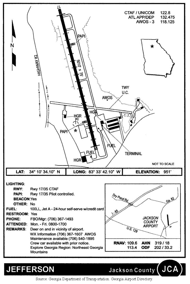
Airport: Jackson County Airport (see illustration).
Airport elevation: The highest point of an airports usable landing area measured in feet from sea level. For purposes of this division, the airport elevation is 950.6 feet mean sea level.
Approach surface: A surface longitudinally centered on the extended runway centerline and extending outward and upward from each end of the primary surface. An approach surface is applied to each end of each runway based upon the type of approach available or planned for that runway end. The inner edge of the approach surface is the same width as the primary surface and it expands uniformly to a width of: 1,250 feet for that end of a utility runway with only visual approaches; 1,500 feet for that end of a runway other than a utility runway with only visual approaches; 2,000 feet for that end of a utility runway with a non-precision instrument approach; 3,500 feet for that end of a non-precision instrument runway other than utility, having visibility minimums greater that three-fourths of a statute mile; 4,000 feet for that end of a non-precision instrument runway, other than utility, having a non-precision instrument approach with visibility minimums as low as three-fourths statute mile; and 16,000 feet for precision instrument runways. The approach surface extends for a horizontal distance of: 5,000 feet at a slope of 20 to one for all utility and visual runways; 10,000 feet at a slope of 34 to one for all non-precision instrument runways other than utility; and 10,000 feet at a slope of 50 to one with an additional 40,000 feet at a slope of 40 to one for all precision instrument runways. The outer width of an approach surface to an end of a runway will be that width prescribed for the most precise approach existing or planned for that runway end.
Conical surface: A surface extending outward and upward from the periphery of the horizontal surface at a slope of 20 to one for a horizontal distance of 4,000 feet.
Departure end of runway: The end of the runway that is opposite the landing threshold. It is sometimes referred to as the stop end of runway.
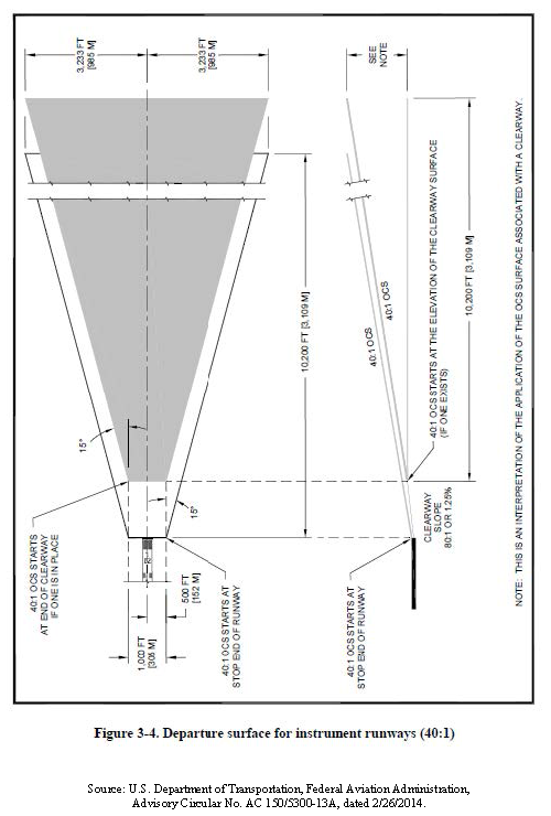
Departure surface: A trapezoidal shape that begins at the end of the takeoff distance available (TODA) and extends along the extended runway centerline and with a slope, starting at the elevation of the end of the TODA, of one unit vertically for every 40 units horizontally. Departure surfaces, when clear, allow pilots to follow standard departure procedures.
Hazard to air navigation: An obstruction determined to have a substantial adverse effect on the safe and efficient utilization of the navigable airspace.
Height: For the purpose of determining the height limits in all airport zones set forth in this division, the datum shall be mean sea level elevation unless otherwise specified.
Heliport primary surface: The area of the primary surface coincides in size and shape with the designated takeoff and landing area of a heliport. This surface is a horizontal plane at the elevation of the established heliport elevation.
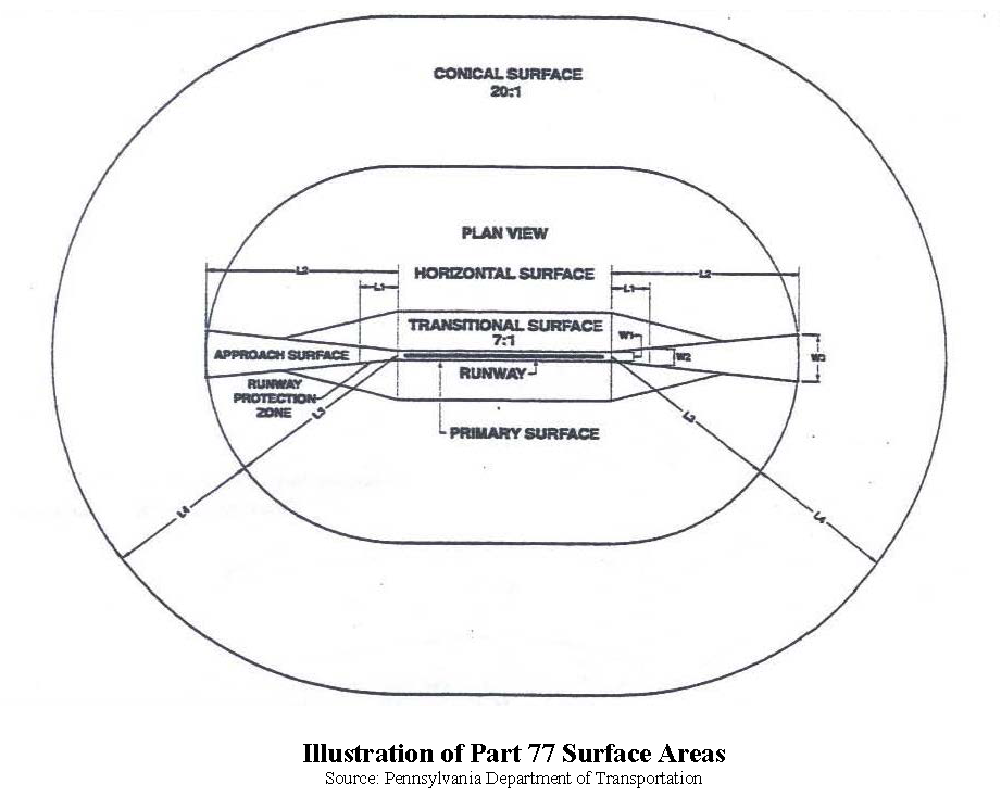
Horizontal surface: A horizontal plane 150 feet above the established airport elevation, the perimeter of which is constructed by swinging arcs of a specified radii from the center of each end of the primary surface of each runway of each airport and connecting the adjacent arcs by lines tangent to those arcs. The radius of each arc is:
(1)
Five thousand feet for all runways designated as utility or visual;
(2)
Ten thousand feet for all other runways.
The radius of the arc specified for each end of a runway will have the same arithmetical value. That value will be the highest determined for either end of the runway. When a 5,000-foot arc is encompassed by tangents connecting two adjacent 10,000-foot arcs, the 5,000-foot arc shall be disregarded on the construction of the perimeter of the horizontal surface.
Instrument departure runway: A runway identified by the airport operator, through the appropriate FAA airports office, to the FAA regional airspace procedures team intended primarily for instrument departures.
Larger than utility runway: A runway that is constructed for and intended to be used by propeller driven aircraft of greater than 12,500 pounds maximum gross weight and jet-powered aircraft.
Nonconforming use: Any pre-existing structure, object of natural growth, or use of land which is inconsistent with the provisions of this division or an amendment thereto.
Non-precision instrument runway: A runway having an existing instrument approach procedure utilizing air navigation facilities with only horizontal guidance, or area type navigation equipment, for which a straight-in non-precision instrument approach procedure has been approved, or planned, and for which no precision approach facilities are planned, or indicated on an FAA planning document or military service military airport planning document.
Obstruction: Any structure, growth, or other object, including a mobile object, which exceeds a limiting height set forth in this division.
Part 77: United States Code of Federal Regulations, Title 14: Aeronautics and Space, chapter I—Federal Aviation Administration, Department of Transportation, subchapter E—Airspace, part 77—Safe, Efficient Use, and Preservation of the Navigable Airspace.
Precision instrument runway: A runway having an existing instrument approach procedure utilizing an Instrument Landing System (ILS), or a Precision Approach Radar (PAR). It also means a runway for which a precision approach system is planned and is so indicated by an FAA-approved airport layout plan; a military service approved military airport layout plan; any other FAA planning document, or military service military airport planning document.
Primary surface: A surface longitudinally centered on a runway. When the runway has a specially prepared hard surface, the primary surface extends 200 feet beyond each end of that runway; but when the runway has no specially prepared hard surface, the primary surface ends at each end of that runway. The elevation of any point on the primary surface is the same as the elevation of the nearest point on the runway centerline. The width of the primary surface is: 250 feet for utility runways having only visual approaches; and 500 feet for utility runways having non-precision instrument approaches. For other than utility runways, the width is: 500 feet for visual runways having only visual approaches; 500 feet for non-precision instrument runways having visibility minimums greater than three-fourths statute mile; 1,000 feet for a non-precision instrument runway having a non-precision instrument approach with visibility minimums as low as three-fourths of a statute mile, and for precision instrument runways. The width of the primary surface of a runway will be that width prescribed in this section for the most precise approach existing or planned for either end of that runway. The elevation of any point on the primary surface is the same as the elevation of the nearest point on the runway centerline.
Runway: A defined area of an airport prepared for landing and takeoff of aircraft along its length.
Structure: An object, including a mobile object, constructed or installed by man, including, but without limitation, buildings, towers, cranes, smokestacks, earth formations and overhead transmission lines.
Transitional surface: These surfaces extend outward and upward at right (90-degree) angles to the runway centerline and the runway centerline extended at a slope of seven to one (seven feet horizontally for each foot vertically) from the sides of the primary surface and from the sides of the approach surfaces to where they intersect the horizontal and conical surfaces. Transitional surfaces for those portions of the precision approach surface which project through and beyond the limits of the conical surface, extend a distance of 5,000 feet measured horizontally from the edge of the approach surface and at right (90-degree) angles to the runway centerline or centerline extended.
Tree: Any object of natural growth.
Utility runway: A runway that is constructed for and intended to be used by propeller driven aircraft of 12,500 pounds maximum gross weight and less.
Visual runway: A runway intended solely for the operation of aircraft using visual approach procedures, with no straight-in instrument approach procedure and no instrument designation indicated on an FAA-approved airport layout plan, a military service approved military airport layout plan, or by any planning document submitted to the FAA by competent authority.
(Ord. No. 17-003, § 1, 10-2-2017)
Sec. 414. - Exemption.
The requirements of this division shall not apply to the construction or maintenance of any structure, or object to a height up to 75 feet above the surface of the land.
(Ord. No. 17-003, § 1, 10-2-2017)
Sec. 415. - Applicability.
Unless exempted by section 414 of this division, the regulations in this division shall apply to the following:
(a)
Any object of natural growth, terrain, or permanent or temporary construction or alteration, including equipment or materials used and any permanent or temporary apparatus; and
(b)
The alteration of any permanent or temporary existing structure by a change in its height, including appurtenances, or lateral dimensions, including equipment or material used therein.
(Ord. No. 17-003, § 1, 10-2-2017)
Sec. 416. - Obstructions.
(a)
Any object of greater height than any of the heights or surfaces (airport zones) established by this overlay district is hereby declared to be an obstruction to air navigation at Jackson County Airport.
(b)
Objects that are considered obstructions under the standards described in title 14 CFR part 77, subpart C—Standards for Determining Obstructions to Air Navigation, as applied to Jackson County Airport per this overlay district, are presumed hazards to air navigation unless further aeronautical study concludes that the object is not a hazard. Once further aeronautical study has been initiated, the Federal Aviation Administration (FAA) will use the standards in subpart C—Standards for Determining Obstructions to Air Navigation of part 77, along with FAA policy and guidance material, to determine if the object is a hazard to air navigation. Such standards are used to determine obstructions to air navigation, and they establish the process for aeronautical studies of obstructions to air navigation or navigational facilities to determine the effect on the safe and efficient use of navigable airspace.
(Ord. No. 17-003, § 1, 10-2-2017)
Sec. 417. - Uses, structures and objects regulated.
Unless exempted by section 414 of this division, within the boundaries of this overlay district, no land shall be used and no structure or object including trees shall be erected or otherwise established, unless said use or structure, tree or object complies with the requirements of this division.
(Ord. No. 17-003, § 1, 10-2-2017)
Sec. 418. - Airport zones established.
For purposes of regulating height of buildings, structures and objects, the following airport zones are established for Jackson County Airport within the boundaries of the airport height overlay district. The zones are civil airport imaginary surfaces established under § 77.19 of part 77. In order to carry out the provisions of this division, there are hereby created and established certain zones which include all of the land lying beneath the approach surfaces, transitional surfaces, horizontal surfaces, and conical surfaces as they apply to Jackson County Airport. An area located in more than one of the following zones is considered to be only in the zone with the more restrictive height limitation. The following civil airport imaginary surfaces are established with relation to the airport and to each runway. The size of each such imaginary surface is based on the category of each runway according to the type of approach available or planned for that runway. The slope and dimensions of the approach surface applied to each end of a runway are determined by the most precise approach procedure existing or planned for that runway end. The various zones are hereby established and defined as follows:
(a)
Utility runway visual approach zone. The inner edge of the approach zone coincides with the width of the primary surface and is 75 feet wide and the cross wind or secondary runway which is 60 feet wide. The approach zone expands outward uniformly to a width of 1,250 feet at a horizontal distance of 5,000 feet from the primary surface. Its centerline is the continuation of the centerline of the runway
(b)
Utility runway non-precision instrument approach zone. The inner edge of this approach zone coincides with the width of the primary surface and is 500 feet wide. The approach zone expands outward uniformly to a width of 2,000 feet at a horizontal distance 5,000 feet from the primary surface. Its centerline is the continuation of the centerline of the runway.
(c)
Runway larger than utility visual approach zone. The inner edge of the approach zone coincides with the width of the primary surface and is 75 feet wide and the cross wind or secondary runway which is 60 feet wide. The approach zone expands outward uniformly to a width of 1,500 feet at a horizontal distance of 5,000 feet from the primary surface. Its centerline is the continuation of the centerline of the runway.
(d)
Runway larger than utility with a visibility minimum greater than three-quarter mile non-precision instrument approach zone. The inner edge of the approach zone coincides with the width of the primary runway which is 75 feet wide and the cross wind or secondary runway which is 60 feet wide. The approach zone expands outward uniformly to a width of 3,500 feet at a horizontal distance of 10,000 feet from the primary surface. Its centerline is the continuation of the centerline of the runway.
(e)
Runway larger than utility with a visibility minimum as low as 3/4 mile non-precision instrument approach zone. The inner edge of this approach zone coincides with the width of the primary surface and is 1,000 feet wide. The approach zone expands outward uniformly to a width of 4,000 feet at a horizontal distance of 10,000 feet from the primary surface. Its centerline is the continuation of the centerline of the runway.
(f)
Precision instrument runway approach zone. The inner edge of this approach zone coincides with the width of the primary surface and is 1,000 feet wide. The approach zone expands outward uniformly to a width of 16,000 feet at a horizontal distance of 50,000 feet from the primary surface. Its centerline is the continuation of the centerline of the runway.
(g)
Heliport approach zone. The inner edge of this approach zone coincides with the width of the primary surface and is (reserved) feet wide. The approach zone expands outward uniformly to a width of 500 feet at a horizontal distance of 4,000 feet from the primary surface.
(h)
Transitional zones. The transitional zones are the areas beneath the transitional surfaces.
(i)
Heliport transitional zones. These zones extend outward from the sides of the primary surface and the heliport approach zones a horizontal distance of 250 feet from the primary surface centerline and the heliport approach zone centerline.
(j)
Horizontal zone. The horizontal zone is established by swinging arcs of 5,000 feet radii for all runways designated utility or visual and 10,000 feet for all other from the center of each end of the primary surface of each runway and connecting the adjacent arcs by drawing lines tangent to those arcs. The horizontal zone does not include the approach and transitional zones.
(k)
Conical zone. The conical zone is established as the area that commences at the periphery of the horizontal zone and extends outward therefrom a horizontal distance of 4,000 feet.
(l)
Departure zone. A 40:1 instrument departure surface associated with the ends of designated instrument departure runways is established.
(Ord. No. 17-003, § 1, 10-2-2017)
Sec. 419. - Airport zone height limitations established.
No structure shall be erected, altered, or maintained, and no object including tree shall be allowed to grow or be established in any zone created by this division to a height in excess of the applicable height limit herein established for such zone. Such applicable height limitations are hereby established for each zone as follows:
(a)
Utility runway visual approach zone. Slopes 20 feet outward for each foot upward beginning at the end of and at the same elevation as the primary surface and extending to a horizontal distance of 5,000 feet along the extended runway centerline.
(b)
Utility runway non-precision instrument approach zone. Slopes 20 feet outward for each foot upward beginning at the end of and at the same elevation as the primary surface and extending to a horizontal distance of 5,000 feet along the extended runway centerline.
(c)
Runway larger than utility visual approach zone. Slopes 20 feet outward for each foot upward beginning at the end of and at the same elevation as the primary surface and extending to a horizontal distance of 5,000 feet along the extended runway centerline.
(d)
Runway larger than utility with a visibility minimum greater than three-quarter mile non-precision instrument approach zone. Slopes 34 feet outward for each foot upward beginning at the end of and at the same elevation as the primary surface and extending to a horizontal distance of 10,000 feet along the extended runway centerline.
(e)
Runway larger than utility with a visibility minimum as low as three-quarter mile non-precision instrument approach zone. Slopes 34 feet outward for each foot upward beginning at the end of and at the same elevation as the primary surface and extending to a horizontal distance of 10,000 feet along the extended runway centerline.
(f)
Precision instrument runway approach zone. Slopes 50 feet outward for each foot upward beginning at the end of and at the same elevation as the primary surface and extending to a horizontal distance of 10,000 feet along the extended runway centerline; thence, slopes upward 40 feet horizontally for each foot vertically to an additional horizontal distance of 40,000 feet along the extended runway centerline.
(g)
Heliport approach zone. Slopes eight feet outward for each foot upward beginning at the end of and at the same elevation as the primary surface and extending to a distance of 4,000 feet along the heliport approach zone centerline.
(h)
Transitional zones. Slope seven feet outward for each foot upward beginning at the sides of and at the same elevation as the primary surface and the approach surface, and extending to a height of 150 feet above the airport elevation which is 950.6 feet above mean sea level. In addition to the foregoing, there are established height limits sloping seven feet outward for each foot upward beginning at the sides of and at the same elevation as the approach surface, and extending to where they intersect the conical surface. Where the precision instrument runway approach zone projects beyond the conical zone, there are established height limits sloping seven feet outward for each foot upward beginning at the sides of and at the same elevation as the approach surface, and extending a horizontal distance of 5,000 feet measured at 90 degree angles to the extended runway centerline.
(i)
Heliport transitional zone. Slope two feet outward for each foot upward beginning at the sides of and at the same elevation as the primary surface and the heliport approach zones and extending a distance of 250 feet measured horizontally from and at 90 degree angles to the primary surface centerline and heliport approach zones centerline.
(j)
Horizontal zone. Established at 150 feet above the airport elevation or at a height of 950.6 feet above mean sea level.
(k)
Conical zone. Slopes 20 feet outward for each foot upward beginning at the periphery of the horizontal zone and at 150 feet above the airport elevation and extending to a height of 350 feet above the airport elevation.
(l)
Departure zone. A 40:1 instrument departure surface associated with the ends of designated instrument departure runways is established (see figure).
(Ord. No. 17-003, § 1, 10-2-2017)
Sec. 420. - Land use restrictions.
Notwithstanding the exemption provided in section 413 of this division, no use may be made of land or water within any zone established by this division in such a manner as to create electrical interference with navigational signals or radio communication between the airport and aircraft, make it difficult for pilots to distinguish between airport lights and others, result in glare in the eyes of the pilots using the airport, impair visibility in the vicinity of the airport, create bird strike hazards, or otherwise in any way endanger or interfere with the landing, takeoff, or maneuvering of aircraft intending to use the airport.
(Ord. No. 17-003, § 1, 10-2-2017)
Sec. 421. - Airport zone permit.
(a)
Except as specifically provided in this section, no material change shall be made in the use of land, no structure or object shall be erected or otherwise established, and no tree shall be planted in any airport zone created by this division unless a permit therefore shall have been applied for and granted.
(b)
Each application for a permit shall indicate the purpose for which the permit is desired, with sufficient particularity to permit it to be determined whether the resulting use, structure, or tree would conform to the regulations of this division.
(c)
If such determination is that the proposed use of land, structure, object or tree conforms to the requirements of this division, the permit shall be granted.
(d)
No permit for a use inconsistent with the provisions of this division shall be granted unless a variance has been approved in accordance with the provisions of this division.
(e)
In determining whether to issue a permit per this division, the public development director may consult the airport manager and the Georgia Department of Transportation as well as any technical guidance documents of the Federal Aviation Administration (FAA), specifically including but not necessarily limited to U.S. Department of Transportation, Federal Aviation Administration Advisory Circular (AC) 150/5300-13A, "Airport Design" dated 2/26/2014, as may be amended, or successor publication.
(Ord. No. 17-003, § 1, 10-2-2017)
Sec. 422. - Permit exemptions.
(a)
Horizontal and conical zones. In the area lying within the limits of the horizontal zone and conical zone, no permit shall be required for any tree or structure less than 75 feet of vertical height above the ground, except when, because of terrain, land contour, or topographic features, such tree or structure would extend above the height limits prescribed for such zones.
(b)
Approach zones. In areas lying within the limits of the approach zones, but at a horizontal distance of not less than 4,200 feet from each end of the runway, no permit shall be required for any tree or structure less than 75 feet of vertical height above the ground, except when such tree or structure would extend above the height limit prescribed for such approach zones.
(c)
Transition zones. In the areas lying within the limits of the transition zones beyond the perimeter of the horizontal zone, no permit shall be required for any tree or structure less than 75 feet of vertical height above the ground, except when such tree or structure, because of terrain, land contour, or topographic features, would extend above the height limit prescribed for such transition zones.
Nothing contained in any of the foregoing exceptions shall be construed as permitting or intending to permit any construction, or alteration of any structure, or growth of any tree in excess of any of the height limits established by this division unless specifically excepted otherwise by this division.
(Ord. No. 17-003, § 1, 10-2-2017)
Sec. 423. - Variances.
(a)
Authority to apply. Any person desiring to erect or increase the height of any structure, or permit the growth of any tree, or use property, not in accordance with the regulations prescribed in this division, may apply to the board of adjustment for a variance from such regulations (see article 14 of this UDC).
(b)
Application. The application for variance shall be accompanied by a determination from the Federal Aviation Administration (FAA) as to the effect of the proposal on the operation of air navigation facilities and the safe, efficient use of navigable airspace.
(c)
Review. No application for variance to the requirements of this division may be considered by the board of adjustment unless a copy of the application has been furnished to the fixed based operator for advice as to the aeronautical effects of the variance. If the fixed base operator does not respond to the application within 15 days after receipt, the board of adjustment may act on its own to grant or deny said application.
(d)
Criteria for approval. A variance shall be allowed where it is duly found that a literal application of enforcement of the regulations will result in unnecessary hardship and relief granted, will not be contrary to the public interest, will not create a hazard to air navigation, will do substantial justice, and will be in accordance with the spirit of this division.
(e)
Conditions on variances. The board of adjustment is authorized to condition the approval of a variance to require the owner of the structure or tree in question, whether at public or his/her own expense, to install, operate and maintain such markers and lights as may be deemed necessary by the board, acting with the advice and recommendation of the Federal Aviation Administration (FAA), Georgia Department of Transportation, or the airport manager.
(Ord. No. 17-003, § 1, 10-2-2017)
Sec. 424. - Nonconforming uses.
(a)
Regulations not retroactive. The regulations in this division shall not be construed to require the removal, lowering, or other change or alteration of any structure or tree not conforming to the regulations at the effective date of this division, or otherwise interfere with the continuance of nonconforming use. nothing contained herein shall require any change in the construction, alteration, or intended use of any structure, the construction or alteration of which was begun prior to the effective date of this division.
(b)
Marking and lighting. Notwithstanding the preceding provision of this section, the owner of any existing nonconforming structure or tree is hereby required to permit the installation, operation, and maintenance thereon of such markers and lights as shall be deemed necessary by the Federal Aviation Administration (FAA), Georgia Department of Transportation, or airport manager to indicate to the operators of aircraft in the vicinity of the airport the presence of such airport obstruction. Unless otherwise specifically provided, such markers and lights shall be installed, operated, and maintained at the expense of the Jackson County Airport Authority.
(c)
Expansion of nonconforming use. No permit required by this division shall be granted that would allow the establishment or creation of an obstruction or permit a nonconforming use, structure, or tree to become a greater hazard to air navigation than it was on the effective date of this division or any amendments thereto or than it is when the application for a permit is made.
(d)
Abandonment. Whenever the public development director determines that a nonconforming tree or structure has been abandoned or more than 80 percent torn down, physically deteriorated, or decayed, no permit shall be granted that would allow such structure or tree to exceed the applicable height limit or otherwise deviate from the requirements of this division.
(Ord. No. 17-003, § 1, 10-2-2017)
Sec. 425. - Other interferences with airport operations prohibited.
(a)
No structures, buildings or other improvements, nor emissions or transmissions, including, but not limited to light, communications, sound, radio waves, electronic interference, radar, smoke, steam or fog, nor any other operational aspects of any sort related to such structures, buildings or improvements, shall be permitted that would potentially interfere airport, aircraft, or navigational aid operations.
(b)
When Federal Aviation Administration (FAA) airport design requirements differ from this UDC, the FAA criteria shall take precedence.
(Ord. No. 17-003, § 1, 10-2-2017)
Sec. 426. - Review and approval process.
The following review procedures shall be required for development or building within the overlay district.
(a)
Prospective developers will submit a completed Federal Aviation Administration (FAA) Airspace Study Checklist for proposed airport development. Checklists are available through the airport manager.
(b)
Copies of all plans and specifications including building elevations and finish samples shall be provided to the airport authority for consideration. Approval by the airport authority shall precede approval from the Jackson County Public Development Department. Once approval has been granted, the following signature block shall be added to the cover page of plans and signed prior to approval by the Jackson County Public Development Department.
"Certificate of Project Approval
All applicable requirements of the Jackson County Airport Authority relative to project approval having been fulfilled, approval of this [site plan] is hereby granted by the Jackson County Airport Authority, subject to further compliance with all provisions of the Jackson County Unified Development Code.
(Ord. No. 17-003, § 1, 10-2-2017)
Sec. 431. - Applicability and exemption.
(a)
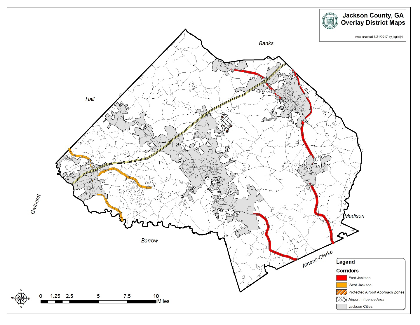
This division applies to land in unincorporated Jackson County along State Route 15 Alt., U.S. Highway 441, State Route 98, State Route 334, State Route 326, and U.S. Highway 129 from the Clarke County line to the Arcade city limits, the boundaries of which are as depicted on the official zoning map or overlay district map as the East Jackson Corridor Overlay District. The overlay district boundary is drawn 500 feet from the centerline of the highway, or if a divided highway, from the centerline of the nearest direction of travel. The entire parcel of any parcel that is partially contained in the overlay district shall be subject to the requirements of the overlay district, even if subsequently subdivided.
(b)
This division applies to land in unincorporated Jackson County along Lewis Braselton Boulevard, Davis Street, SR 124 and SR 53, the boundaries of which are as depicted on the official zoning map or overlay district map as the West Jackson Corridor Overlay District. The overlay district boundary is drawn 500 feet from the centerline of the highway, or if a divided highway, from the centerline of the nearest direction of travel. The entire parcel of any parcel that is partially contained in the overlay district shall be subject to the requirements of the overlay district, even if subsequently subdivided.
(c)
This division shall not apply to any development, improvement, building or structure, or plans or permits therefor, which was approved prior to the effective date of adoption of the West Jackson Corridor Overlay District and the East Jackson Corridor Overlay District, as applicable.
(Ord. No. 17-003, § 1, 10-2-2017)
Sec. 432. - Uses requiring special use approval.
Notwithstanding the permitted use provisions for zoning districts established in article 2 of this UDC, the following uses if located within the East and West Jackson Corridor Overlay Districts in addition to abiding by the applicable underlying zoning district use requirements, shall require special use approval in accordance with the procedures of article 14 of this UDC for special uses:
(a)
Adult entertainment establishment.
(b)
Automobile or other vehicle repair or paint.
(c)
Commercial recreational facility, outdoor.
(d)
Group home, or rooming or boarding house.
(e)
Pawn shop.
(f)
Payday loan establishment.
(g)
Salvage yard, junk yard, materials recovery processing.
(h)
Tow service.
(i)
Wrecked motor vehicle compound.
(j)
Outside display and/or storage, in the HRC, LI, GI, and HI zoning districts.
(Ord. No. 17-003, § 1, 10-2-2017)
Sec. 433. - Building height.
The height of any building to be placed in the East and West Jackson Corridor Overlay Districts shall be limited to three stories, unless a special use is granted by the Jackson County Board of Commissioners in accordance with article 14 of this UDC. In addition to special use criteria generally as provided in article 14 of this UDC, the board may consider any of the following factors in making a decision whether to grant special use approval to exceed the three-story maximum building height:
(a)
Proximity and relationship of the proposed building to other buildings that are more than three stories or 35 feet in height.
(b)
Impact of the proposed building on single-family residences on nearby tracts.
(c)
Topography and vegetation that screen the view of the proposed building.
(d)
On-site screening and/or landscaped buffers.
(e)
Provision of public open space in exchange for increased building height.
(f)
The effect of additional building height on traffic congestion.
(g)
Accessibility of the site in relation to traffic patterns.
(h)
Economic development opportunities for Jackson County.
(i)
The necessity of greater building height to the function of the proposed use.
(j)
The quality of the architectural design and its compatibility with its surroundings.
(k)
The capability of the designated fire district to adequately handle a fire or other emergency situation for the proposed structure using existing equipment and personnel.
(Ord. No. 17-003, § 1, 10-2-2017)
Sec. 434. - Ground floor area limitation.
Any new institutional or commercial building within the East and West Jackson Corridor Overlay Districts shall not exceed 200,000 gross square feet in ground floor area, and any new industrial building within the East and West Jackson Corridor Overlay Districts shall not exceed 500,000 square feet in ground floor area, except by special use approval by the board of commissioners. In determining whether to grant such a special use, the Board of Commissioners shall consider the following factors, in addition to considering criteria applicable to special use applications generally as specified in article 14 of this UDC:
(a)
Whether the building site will have safe, immediate access to a public maintained roadway with a functional classification of collector or higher as determined by the public development director;
(b)
Whether the building site will provide convenient interconnections with adjacent uses and properties that serve both pedestrians and automobiles;
(c)
Whether the proposed building floor area is the smallest feasible to serve the function of the proposed use;
(d)
Whether the architectural design of the building reduces the perceived size of the building by appropriate articulations and variations in the massing, façade, roofline, materials, colors, and textures of the building exterior; and
(e)
Whether the building and site meets or exceeds all other standards set forth in this overlay district and this UDC generally.
(Ord. No. 17-003, § 1, 10-2-2017)
Sec. 435. - Minimum nonresidential building floor area.
No nonresidential building shall have less than 2,000 square feet of heated floor space.
(Ord. No. 17-003, § 1, 10-2-2017)
Sec. 436. - Nonresidential lot standards.
No lot shall be divided for nonresidential use within the East and West Jackson Corridor Overlay Districts unless it conforms to the following requirements:
(a)
Minimum lot size: One and one-half acre for outparcels or stand-alone commercial projects, and three acres for outparcels or stand-alone industrial projects.
(b)
Minimum lot frontage for commercial or industrial lot: 175 feet.
(Ord. No. 17-003, § 1, 10-2-2017)
Sec. 437. - Residential lot standards abutting collector or arterial street.
When a residential use or residentially zoned lot abuts a street with a functional classification of collector or arterial as determined by the public development director, said lot shall have frontage on a local street and a minimum 20-foot wide no access easement shall be required along the entire frontage of the lot abutting a collector or arterial street. In addition, within the required 20-foot wide no access easement, one of the following requirements shall be met along the entire lot frontage (excluding any required sight visibility triangle):
(a)
A continuous solid wall no less than four foot high, constructed entirely of brick or stone masonry shall be erected prior to a building permit being issued; or
(b)
A fence no less than four-foot high constructed of iron pickets and intervening brick or stone masonry pillars, one for every 50 feet of fence; or
(c)
A vegetated strip of canopy trees and shrubs, impenetrable by vehicles, approved by the public development department.
(Ord. No. 17-003, § 1, 10-2-2017)
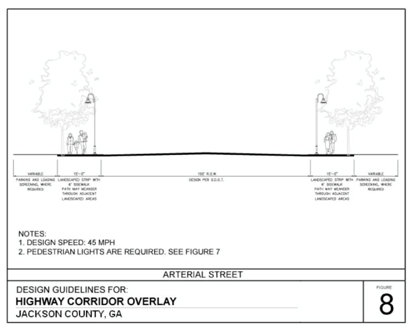
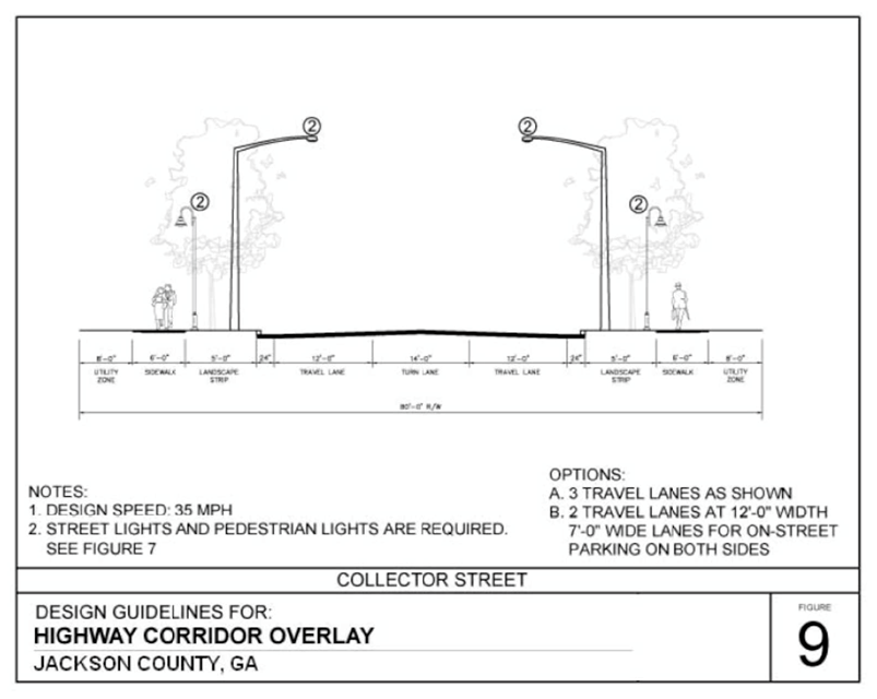
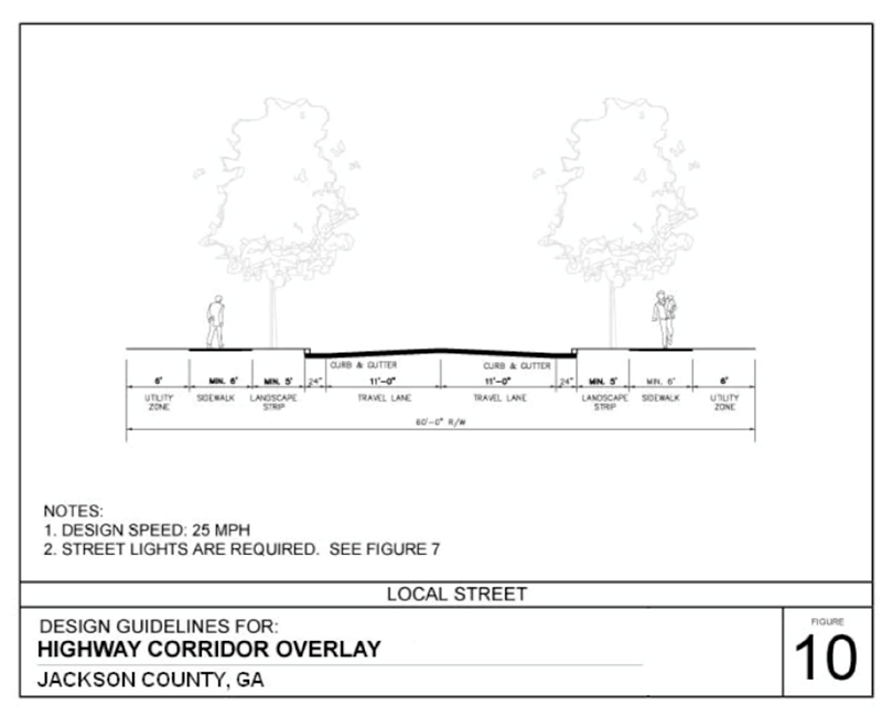
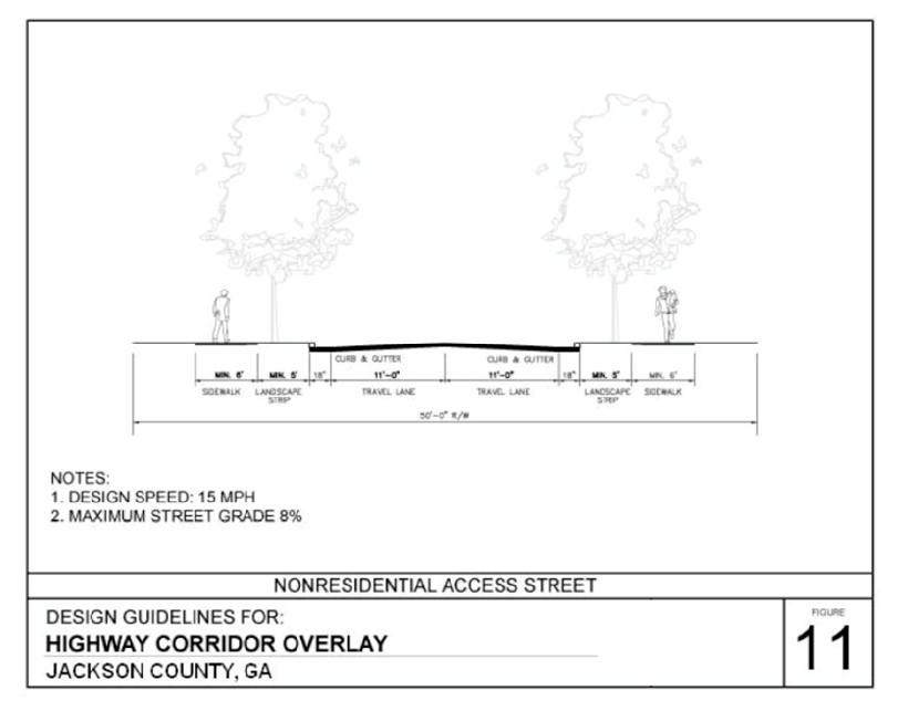
Sec. 438. - Street and streetscape requirements.
Any proposed or future street must meet the requirements of this section. Rights-of-ways existing or proposed to be located within the East and West Jackson Corridor Overlay Districts shall be classified by type (i.e., arterial, collector, local, or access) as determined by the public development director. Existing and proposed streets shall be improved on both sides of the street in accordance with the following standards:
Street and Streetscape Requirements
East and West Jackson Corridor Overlay Districts
(See also street cross-sections at the end of this division)
(Ord. No. 17-003, § 1, 10-2-2017; Ord. No. 21-006, § 8, 7-19-2021)
Sec. 439. - Street and pedestrian network connectivity standards.
This section shall apply to all nonresidential or multi-family developments and any single-family residential development of five or more acres.
(a)
Continuation of streets. All development plans shall incorporate and continue all collector, local, or access streets stubbed to the boundary of the development plan by previously approved development plans or existing development.
(b)
Future street connections. All development plans shall provide for future public street connections (of a street type approved by the public development director) to adjacent developable parcels by providing a street connection spaced at intervals not to exceed 600 feet along each development plan boundary that abuts potentially developable or redevelopable land.
(c)
Maximum local street length. No local street may be longer than 600 feet without an intersection with another local through street. Cul-de-sac streets shall not count as through streets.
(d)
Maximum cul-de-sac street length. Dead-end streets, including cul-de-sac streets, shall not exceed 300 feet in length and shall not serve more than 30 dwelling units.
(e)
Interparcel vehicular access. Developments abutting an arterial or collector street shall provide an access street to abutting commercial or multi-family residential development, whether existing or planned (i.e., according to either the zoning map and/or the future land use map, as determined by the public development director), so as to provide a vehicular connection among all adjacent parcels also abutting an arterial or collector street. This requirement may necessitate driveway aprons, stub-outs, or other design features to provide for cross-connection access to abutting properties as determined by the public development director.
(f)
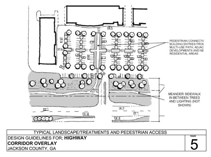
Interparcel pedestrian access. New commercial or multi-family residential development that abuts a planned, new or existing multi-family residential property or commercial property shall provide for a six-foot wide sidewalk connecting the two uses. This provision shall require such developments to construct the required sidewalk to the property line so that it may be continued by the adjacent development for future connectivity.
(g)
Cul-de-sac pedestrian connection. A cul-de-sac street that ends within 200 feet of the right-of-way of an adjacent collector or arterial street shall provide a six-foot wide sidewalk within a minimum ten-foot wide easement connecting the sidewalk on the cul-de-sac to the sidewalk on the adjacent collector or arterial street.
(h)
Internal pedestrian connections. Sidewalks shall be provided to connect building entrances to required sidewalks along street frontage.
(i)
Recorded easement agreement required. Whenever easements are required to facilitate compliance of a development with the standards in this section, an easement agreement must be drafted by the developer and/or property owner and approved by the public development director prior to approval of development plans. Said agreement must allow vehicular and pedestrian access from neighboring developments as they currently exist or any future developments as provided in this section. Said agreement must also be noted on all development plans, and the easement agreement must be recorded in the records of the Jackson County Superior Court Clerk.
(Ord. No. 17-003, § 1, 10-2-2017)
Sec. 440. - Driveways.
Unless the driveway connects with a state route and is governed by more restrictive requirements of the Georgia Department of Transportation for driveways, all driveways shall conform to the following requirements.
(a)
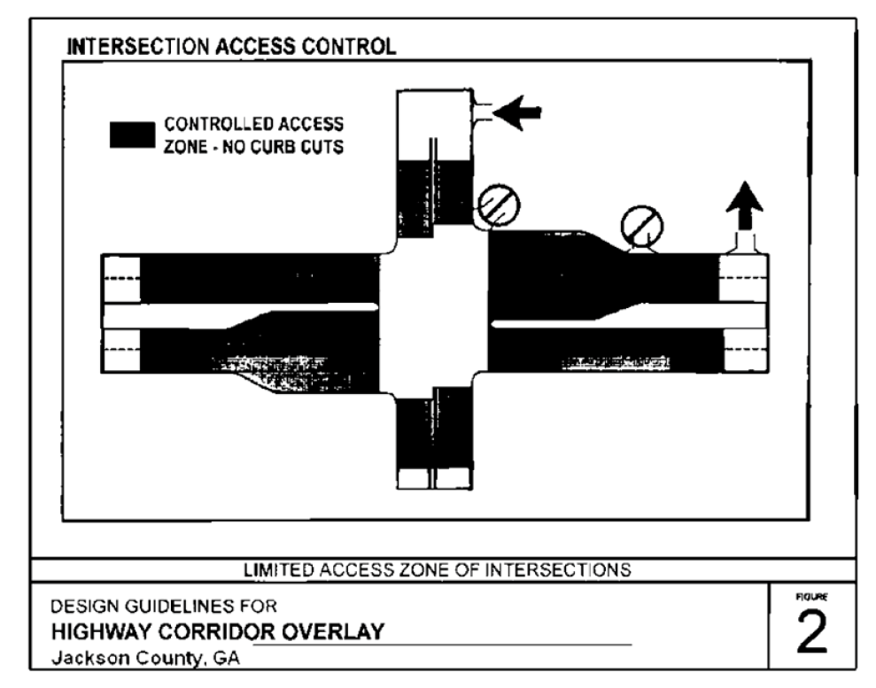
Location precluded. Driveways shall not be permitted within the controlled access zone of an intersection (see figure 2).
(b)
Minimum number of vehicular access points. The minimum number of vehicular access points for nonresidential development shall be as follows:
(c)
Access for outparcels. Outparcels with less than 200 feet of road frontage are restricted to access from within the commercial or industrial development only.
(d)
Driveways at signalized intersection. Driveways connecting with a collector or arterial road that are served with a traffic signal must have at least two outbound lanes and one inbound lane with a minimum width of 11 feet per lane.
(e)
Driveway grades. Except for single-family and two-family residences, driveway grades shall conform to the requirements of the Georgia Department of Transportation Regulations for Driveway and Encroachment Control.
(f)
Driveway alignment. Except where driveways are on opposite sides of a raised median, driveways on opposite sides of a street shall either directly align or have offsets of a minimum of 125 feet, as measured between the extended centerlines of such driveways. Whenever possible, driveways on undivided arterial, collector, or local streets should align with driveways (if any) on the opposite side of such street. On a divided arterial street that includes a median, driveways should align with median breaks whenever possible. Driveways not meeting this standard shall be limited to right turn in and right turn out only.
(g)
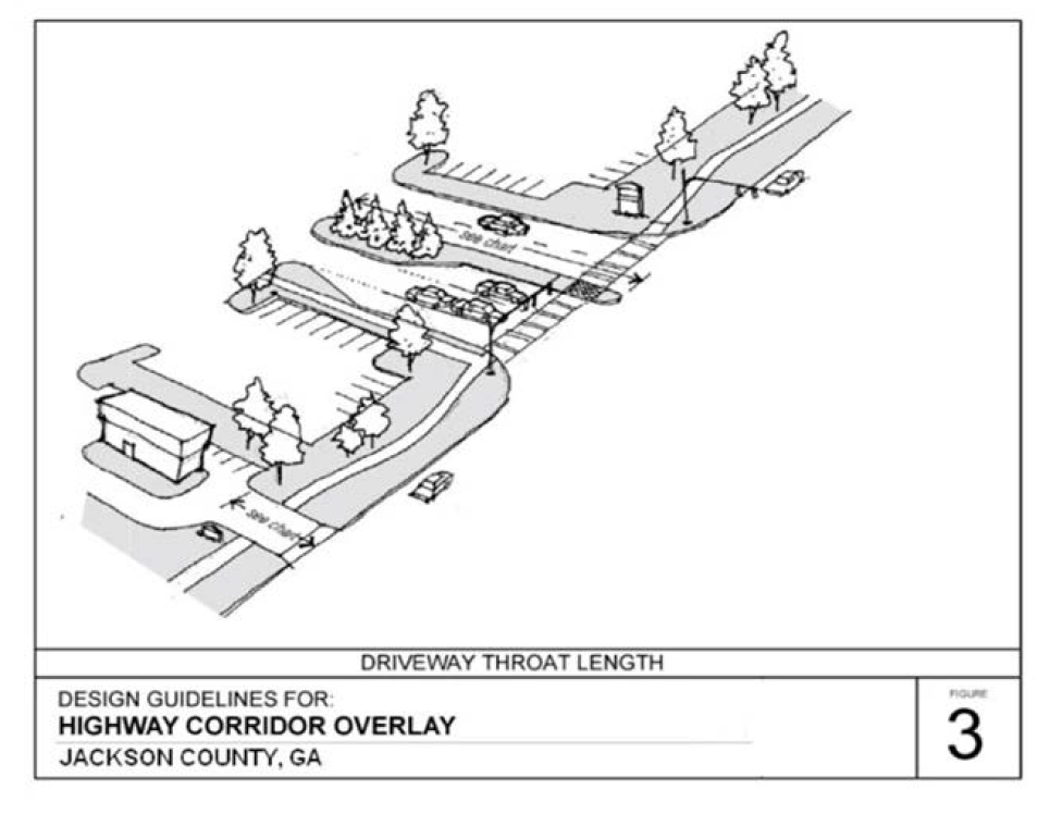
Driveway throat length. The driveway "throat length" (i.e., distance between the driveway intersection and the first turning movement interior to the development) for a commercial or industrial development shall meet the following applicable minimum requirement: provided, however, that the director of public development shall be authorized to reduce the minimum required throat length for driveways with right turns only by one-third of the applicable requirement, for good cause shown (see figure 3).
Minimum Driveway Throat Length by Land Use
(Ord. No. 17-003, § 1, 10-2-2017)
Sec. 441. - Deceleration lanes.
(a)
Driveways connecting to state routes may require a deceleration lane per standards of the Georgia Department of Transportation for driveways. Unless the driveway connects with a state route and is governed by more restrictive requirements of the Georgia Department of Transportation for driveways, all driveways entering an arterial street with a posted speed limit greater than 35 miles per hour shall provide a deceleration lane meeting specifications required by this UDC.
(b)
Any deceleration lane that ends within 75 feet of another driveway or intersecting street shall be lengthened so that it connects with the adjacent street or driveway.
(Ord. No. 17-003, § 1, 10-2-2017)
Sec. 442. - Parking lots.
(a)
Screening. Where a parking lot or loading area for a commercial, industrial, or institutional use abuts a public right-of-way, the required front landscape strip shall provide screening, as defined by this UDC, from the public right-of-way along the entire property line. The location of the required front landscape strip shall be setback from the future right-of-way for the road, not the existing right-of-way of the road, as determined by the public development director.
(b)
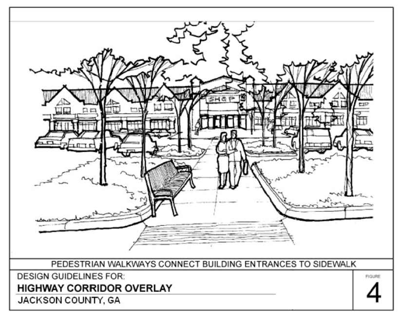
Pedestrian circulation. Parking areas shall be designed to facilitate safe and convenient use by pedestrians. Institutional, commercial and multi-family developments shall provide designated pedestrian pathways or sidewalks connecting the front entrance of the principal building to the sidewalk along the abutting street, including marked crosswalks across interior driveways.
(c)
Paving. All parking areas shall be paved with asphalt or concrete meeting specifications of this UDC, except that pervious materials may be substituted to meet stormwater management requirements, subject to the approval of the public development director.
(Ord. No. 17-003, § 1, 10-2-2017)
Sec. 443. - Dumpsters.
(a)
Location. Dumpsters and trash receptacles shall be located to the rear of the principal building so that they are not visible from any public street or any adjacent residentially zoned and residentially used properties. Dumpsters shall be set back a minimum of five feet from all property lines. Dumpsters shall not be located within any required buffer or landscape strip.
(b)
Screening. Dumpsters shall, regardless of location, be screened on three sides with a solid masonry wall to match the principal building, eight feet in height with an opaque gate on the accessible side.
(c)
Pad. Dumpsters shall be placed on concrete pads of sufficient size and strength to support the weight of service vehicles. Restaurants and other food service establishments shall place dumpsters on concrete pads that are designed to slope into a drain that is equipped with a grease trap.
(Ord. No. 17-003, § 1, 10-2-2017)
Sec. 444. - HVAC and mechanical equipment.
(a)
All ground mechanical, HVAC, and like systems shall be screened from public street view (within 300 feet) on all sides by an opaque masonry wall or landscaping.
(b)
For all buildings, roof-mounted mechanical, HVAC, and like systems shall be screened from public street view (within 300 feet) on all sides by a raised parapet or pitched roof along the edge of the roofline.
(Ord. No. 17-003, § 1, 10-2-2017)
Sec. 445. - Building architecture, materials and colors.
(a)
Applicability. The following design guidelines and standards apply to all newly constructed buildings used for multi-family residential, office, institutional, commercial, or industrial purposes to include all accessory structures. These standards do not apply to single-family residential or duplex uses.
(b)
Architectural review. All design and construction for buildings subject to this section shall require architectural review by the public development department for consistency with the provision of this section. All building plans must be submitted with the development plan for review. All building plans shall clearly indicate all of the proposed building materials and colors for each façade sufficient to demonstrate compliance with this section. Approval of architecture must be granted by the public development department prior to issuance of a development permit.
(c)
Consistent architectural identity. Buildings that are located within the same development shall be constructed of similar materials and colors to show continuity between all out parcels, accessory buildings, and principal building. The use of a common palette of building materials should be maintained for building façades to create a consistent and traditional architectural identity. Traditional architecture shall include, for example, the use of brick, pitched roofs, low-profile signage, and subdued colors.
(d)
Building orientation. Principal building entrances shall be oriented to public streets.
(e)
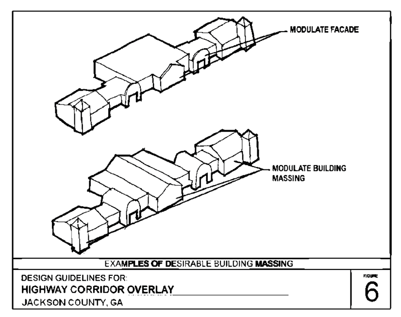
Modulation. For projects with more than one commercial/retail building and multi-family residential developments, variations in façade, roofline and depth should be provided to lend the appearance of multi-tenant occupancy. The massing of building façades longer than 150 feet that are approximately parallel to the right-of-way and oriented to a public street shall be modulated to increase visual interest, as follows:
1.
Building façades that are less than 500 feet long shall be modulated at intervals no greater than 100 feet in length.
2.
Building façades that are more than 500 feet long shall be modulated at intervals no greater than 20 percent of the length of the façade.
(f)
Contrasting base. Building designs shall include a minimum two-foot high contrasting base, along the entire front façade of buildings and extending for a distance of at least ten feet along the sides of buildings.
(g)
Primary building materials. This subsection specifies the primary building materials that may be used and combined to create a consistent, attractive, interesting and long-lasting building design. There shall be no more than two primary building materials used on a single building façade (excludes authorized use of secondary or accent materials). This subsection does not apply to doors:
1.
Brick, except that brick veneers that are intended to simulate brick exteriors are not acceptable.
2.
Stone. Natural stone such as, but not limited to, granite, limestone, and acid marble are allowed building materials. Terra cotta and/or cast stone, which simulate natural stone, are also acceptable. Painted stone is not allowed.
3.
Split-face block/concrete masonry unit (CMU) is restricted to ten percent of the surface area of the façade on institutional and commercial buildings and 50 percent on industrial buildings.
4.
Tilt/architectural pre-cast concrete is permitted by special use approval only and with a design plan consistent with the surrounding development and area
5.
High grade stucco is restricted to 50 percent of the surface area of a façade (the amount of material shall be calculated using the gross square footage of wall area per façade).
6.
Natural wood and/or cement-based artificial wood siding are allowed only for residential buildings.
7.
Glass is restricted to 50 percent of the wall area per façade.
8.
Metal is allowed up to 25 percent of the surface area of a façade for commercial and institutional buildings.
9.
Exposed concrete block and tile are not allowed as building materials on a façade.
(h)
Secondary (accent) materials. Other building materials not authorized as primary building materials in this section, such as but not limited to wood and tile, may be used as secondary or accent building materials to enhance the façade of the building or for decorative elements not exceed 15 percent of total wall area per façade for institutional and commercial buildings and 30 percent of total wall area per façade for industrial buildings.
(i)
Accent colors. Contrasting accent colors on any single façade shall be limited to no more than ten percent of the total wall area for any single façade. If permitted, any exterior lighted bands shall be considered as part of the maximum ten percent of contrasting accent colors.
(j)
Canopy support columns. The support columns for drive under canopies for gasoline pumps shall be made of the same material as the primary building on the property and shall match the trim and accent material. Trim or accent material may account for up to ten percent or 120 square feet, whichever is less, of any facade. Any signage on the canopy shall be counted towards the ten percent accent material maximum, in addition to having to meet signage requirements of this UDC.
(k)
Arcade or structural canopy for retail use. For any multi-tenant commercial development, a covered arcade/structural canopy shall be provided along the front façade of the building. Arcades are covered walkways connected to the principal building. They should be a minimum of five feet in width and designed to provide covered areas for relief from the weather. Different arcade/structural canopy designs may be used for each individual tenant/business within a multi-tenant commercial development, provided that they blend aesthetically with the front façade of the building and are approved by the public development director.
(l)
Roof requirements.
1.
Pitched roofs. Pitched roofs of at least 3:12 are required for one-story buildings and may be required for taller buildings. A combination of flat roof and pitched roof may be acceptable for buildings of two or more stories if the pitched portion of the roof screens the view from the frontage of any flat roof. Arcades, porches, and other features must be designed with pitched roofs.
2.
Mansard roofs. Mansard roofs shall have a maximum pitch of 12:12 with a minimum 12-foot vertical surface length.
3.
Flat roofs. Building materials for flat roofs shall meet the state building code requirements for nonresidential buildings. Exposed metal flashing shall be copper or factory finished sheet metal. If factory finished metal flashing is used, such as standing seam, the color must be subdued to blend with other materials or of a color to simulate weathered copper or bronze. All buildings and structures with flat roofs should include parapet articulation on the front façade(s) of such building or structure. There shall be roof articulations/offsets at a minimum of one per each 125 linear feet of length by a change in the top line of the parapet. Additional articulation may occur at any lesser distance. If the front façade is less than 125 linear feet of length, then a minimum of one roof articulation must be provided.
4.
Canopies. Drive under canopies for gasoline pumps may have flat roofs with vertical or factory formed facing of finished sheet metal.
(Ord. No. 17-003, § 1, 10-2-2017)
Sec. 446. - Outdoor and street lighting.
(a)
Along the entire property frontage of any new development fronting on and accessing a county road (excludes state routes) in the West Jackson Corridor Overlay District, streetlights shall be required to be installed by the developer at no installation cost to the county consistent with the specifications of this section.
(b)
All parking lot lighting and pedestrian lighting shall meet the specifications of this section.
Lighting Specifications
East and West Jackson Corridor Overlay Districts
(c)
Security lighting shall be semi-cutoff luminaires. The public development director may limit the number of luminaires remaining activated for security lighting to one-fourth of the total number of each type of luminaire used.
(d)
Permanent mounted exposed exterior neon lights shall not be allowed.
(e)
Roof-mounted lights are not permitted.
(f)
Light fixtures for drive-under canopies shall be recessed into the canopy ceiling so that the bottom of the luminaire does not extend below the ceiling of the canopy.
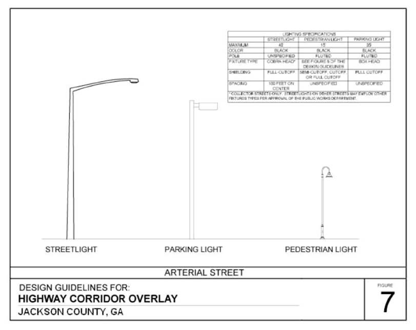
(Ord. No. 17-003, § 1, 10-2-2017)
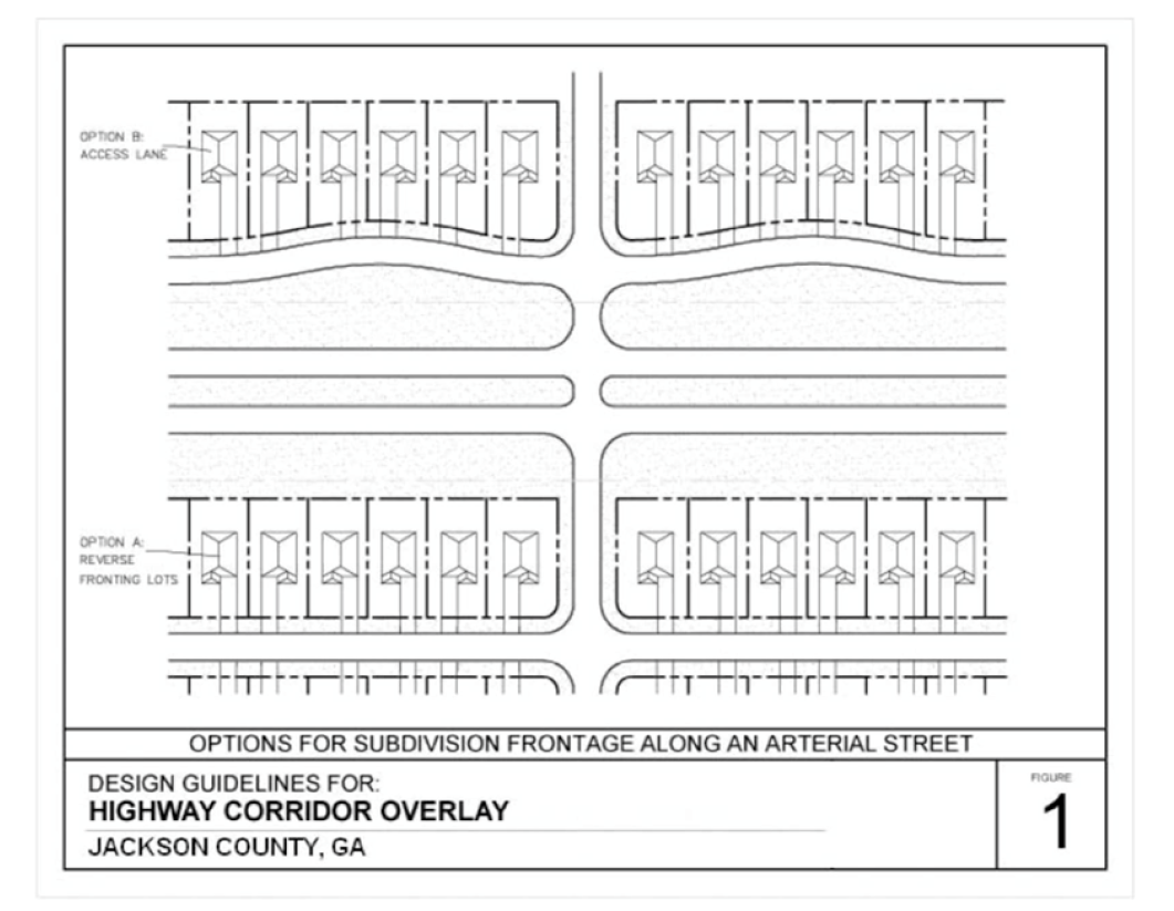
Sec. 447. - Signage.
Except as provided in this section, signage shall comply with the regulations in article 7 of this UDC.
(a)
Prohibitions. Electronic changeable copy signs, neon signs, internally illuminated signs, and the outlining of windows or doors with any lights are prohibited. Externally illuminated signs are allowed, but only with full cut-off luminaires that are directed downward and away from streets and adjacent properties.
(b)
Monument ground signs. Freestanding and project entrance signs shall be limited to ground monument signs. The base and sign structure shall be constructed of materials such as brick, or stone, consistent with the architecture and primary building materials for the building or buildings served.
(c)
Ground sign maximum height. Ground signs for lots zoned commercial or industrial shall be limited to a height of no greater than 15 feet, including the base and sign structure.
(d)
Maximum ground sign area. Ground signs shall not exceed the following maximum areas:
1.
Ground signs on lots zoned commercial or industrial with one tenant: 50 square feet.
2.
Ground signs on lots zoned commercial or industrial, including shared signs, on lots with more than one tenant: 100 square feet.
3.
All other ground signs: 32 square feet.
(Ord. No. 17-003, § 1, 10-2-2017)
Sec. 448. - Landscaping.
(a)
Development within the East and West Jackson Corridor Overlay Districts shall comply with the following landscaping requirements in addition to those landscaping requirements generally applicable to the development as provided in article 12 of this UDC.
(b)
The minimum width of landscape strips abutting a public or private access street shall be 15 feet. The landscape strip shall be planted with one shrub for each five feet of landscape strip frontage and street trees which shall be spaced at approved intervals depending on the type and size of tree planted, as provided in the list of approved tree species provided below.
(c)
The public development department may, upon application, approve different species than those listed in this section, provided that the applicant for modification of approved tree species submits a proposed plan showing desired placement, prepared and stamped by a registered landscape architect, and which includes a planting list with common names, minimum size, and required spacing.
(d)
No more than 25 percent of the trees installed in a development may be of any one genus. No more than 50 percent of the street trees used in a single development shall be of the small tree species.
(Ord. No. 17-003, § 1, 10-2-2017)