
Madison City Zoning Code
SUBCHAPTER 28H
- OVERLAY DISTRICTS
28.101 - APPLICABILITY.
The requirements of the overlay districts shall apply to all zoning lots located in such districts in addition to all requirements in the Madison General Ordinances that apply to the base zoning district classification of those zoning lots.
In the event of a conflict between the provisions of any overlay district and the underlying base zoning district, the provisions of the overlay district shall apply, except where otherwise specified.
(Am. by ORD-23-00013, 1-25-23)
28.102 - WELLHEAD PROTECTION DISTRICTS.
(1)
Statement of Purpose.
The Common Council of the City of Madison finds that certain uses can seriously threaten or degrade groundwater quality. To promote the public health, safety, and general welfare of the City of Madison, the Wellhead Protection Districts are created to protect municipal water supplies.
(2)
Protection Zones.
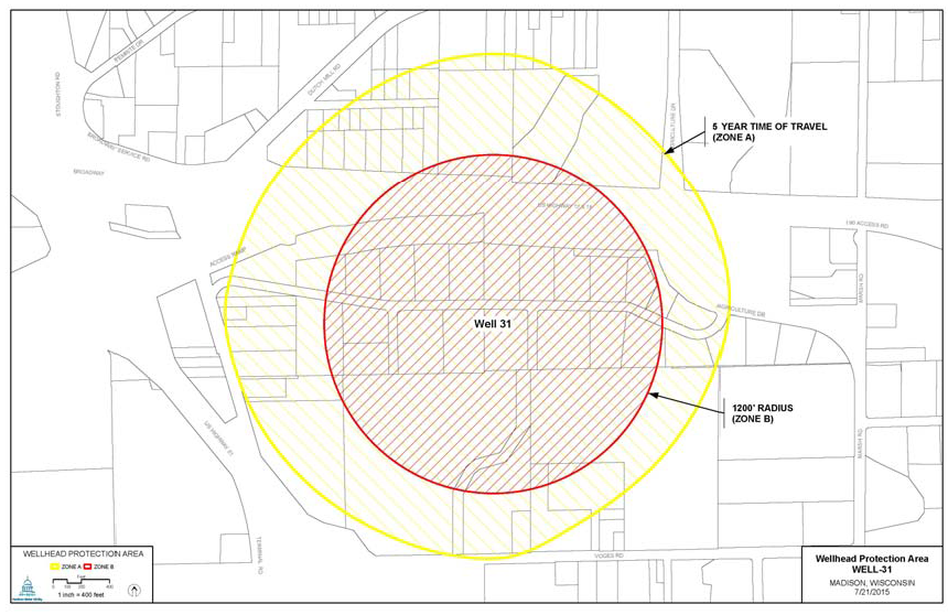
Each wellhead shall have two (2) zones of protection around it.
(a)
Zone A is the area around the well in which it has been determined that groundwater and potential contaminants will take five (5) years or less to reach the pumping well.
(b)
Zone B is the area within a twelve hundred (1,200) foot radius around the well, except for the area in Zone A. (Am. by ORD-21-00009, 2-10-21)
(3)
Uses.
All uses in Zones A and B of any Wellhead Protection District shall be approved by the Water Utility General Manger or their designee. A use may be approved with conditions. Approval by the Water Utility General Manager or their designee is in addition to all other approvals required for the proposed use.
(a)
Permitted Uses In Zones A and B. Any use allowed as permitted in the principal zoning district, except those uses not approved pursuant to Sec. 13.22, MGO.
(b)
Conditional Uses in Zones A and B. Any use allowed as a conditional use in the principal zoning district except those uses not approved pursuant to Sec. 13.22.
(4)
Existing Uses.
Any lawful use existing at the time of the creation of a Wellhead Protection District may be continued, however, no expansion or enlargement of such use is allowed without approval pursuant to Sec. 13.22 by the Water Utility General Manager or their designee.
(5)
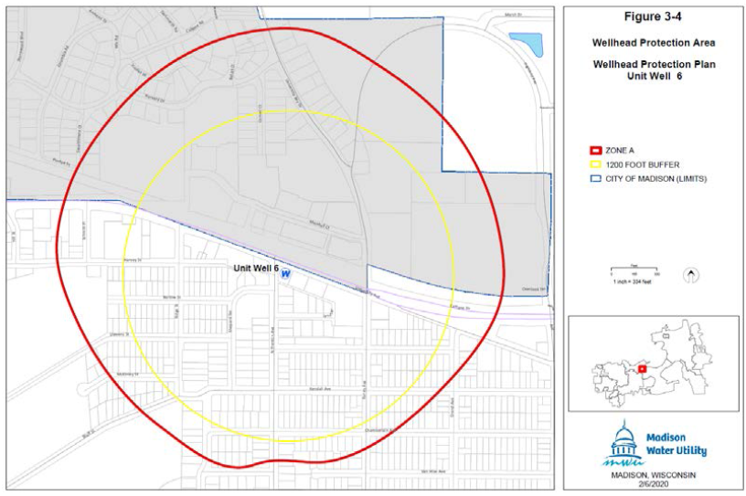
Wellhead Protection District No. 6.
The location of Well No. 6 and the surrounding Zone A and Zone B are shown in Sec. 28.102(5)(a).
(a)
Wellhead Protection District No. 6.
WELL NO. 6
(Am. by ORD-21-00009, 2-10-21)
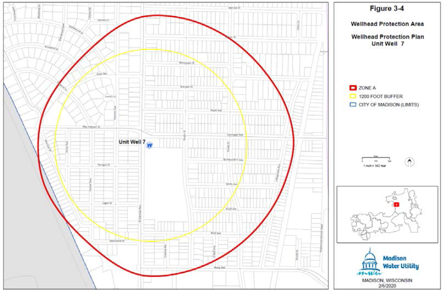
(6)
Wellhead Protection District No. 7.
The location of Well No. 7 and the surrounding Zone A and Zone B are shown in Sec. 28.102(6)(a).
(a)
Map of Wellhead Protection District No. 7.
WELL NO. 7
(Am. by ORD-21-00009, 2-10-21)
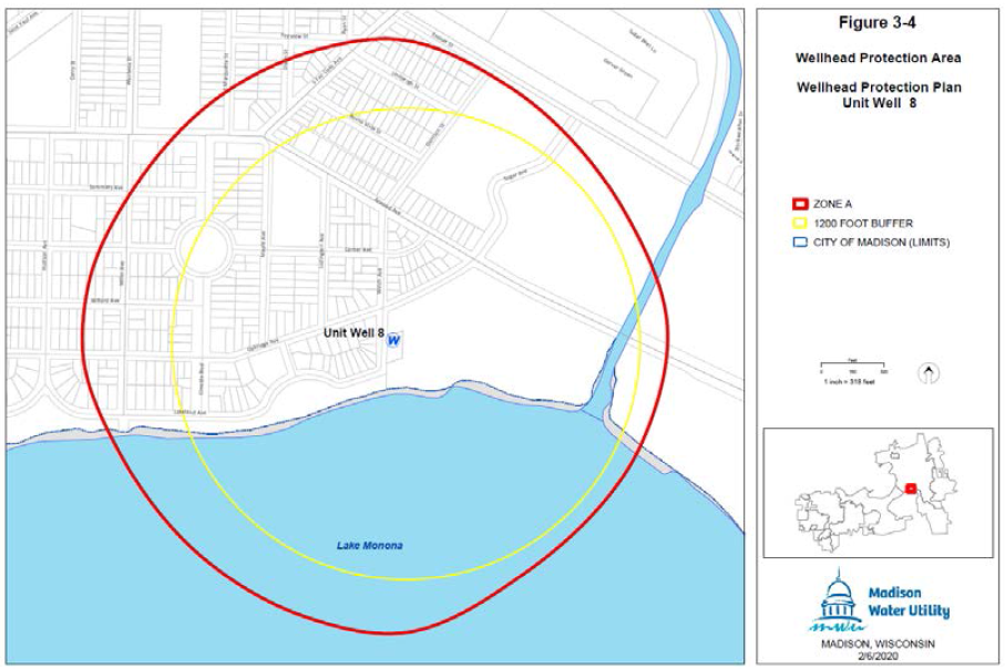
(7)
Wellhead Protection District No. 8.
The location of Well No. 8 and the surrounding Zone A and Zone B are shown in Sec. 28.102(7)(a).
(a)
Map of Wellhead Protection District No. 8.
WELL NO. 8
(Am. by ORD-21-00009, 2-10-21)
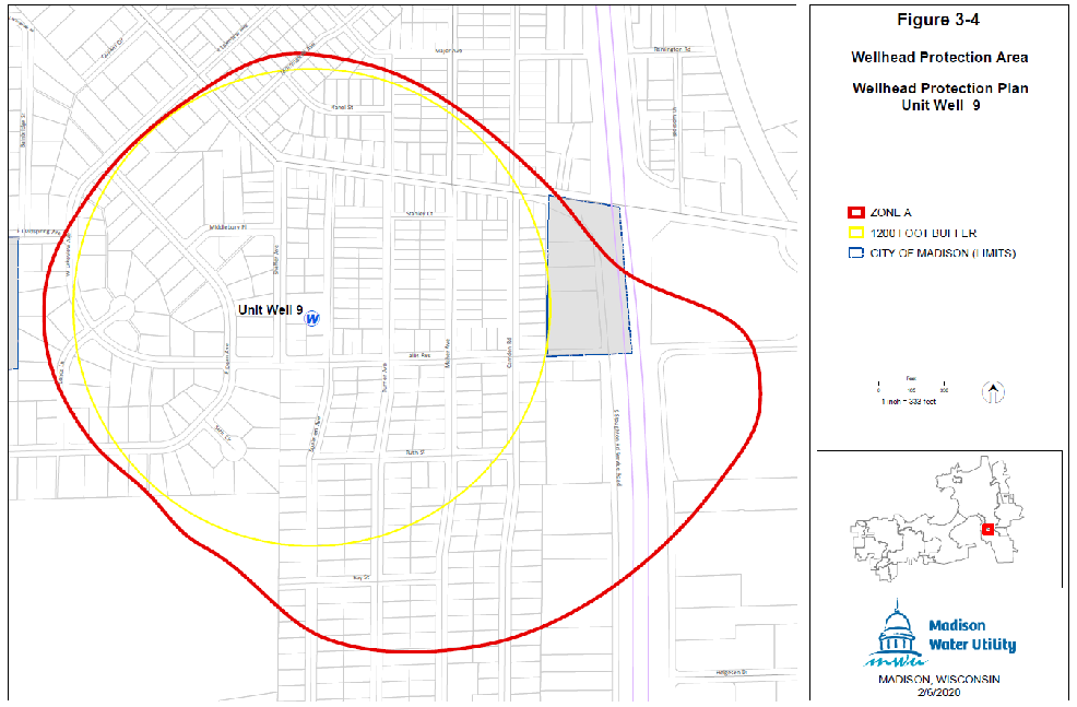
(8)
Wellhead Protection District No. 9.
The location of Well No. 9 and the surrounding Zone A and Zone B are shown in Sec. 28.102(8)(a).
(a)
Map of Wellhead Protection District No. 9.
WELL NO. 9
(Am. by ORD-21-00009, 2-10-21)
(9)
Reserved for Future Use. (Rpld. by ORD-21-00009, 2-10-21)
(10)
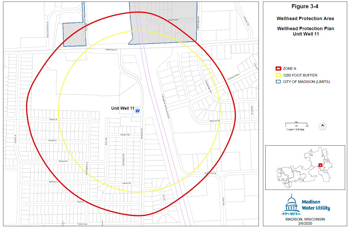
Wellhead Protection District No. 11.
The location of Well No. 11 and the surrounding Zone A and Zone B are shown in Sec. 28.102(10)(a).
(a)
Map of Wellhead Protection District No. 11.
WELL NO. 11
(Am. by ORD-21-00009, 2-10-21)
(11)
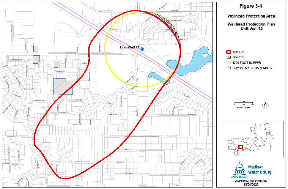
Wellhead Protection District No. 12.
The location of Well No. 12 and the surrounding Zone A and Zone B are shown in Sec. 28.102(11)(a).
(a)
Map of Wellhead District No. 12.
WELL NO. 12
(Am. by ORD-21-00009, 2-10-21)
(12)
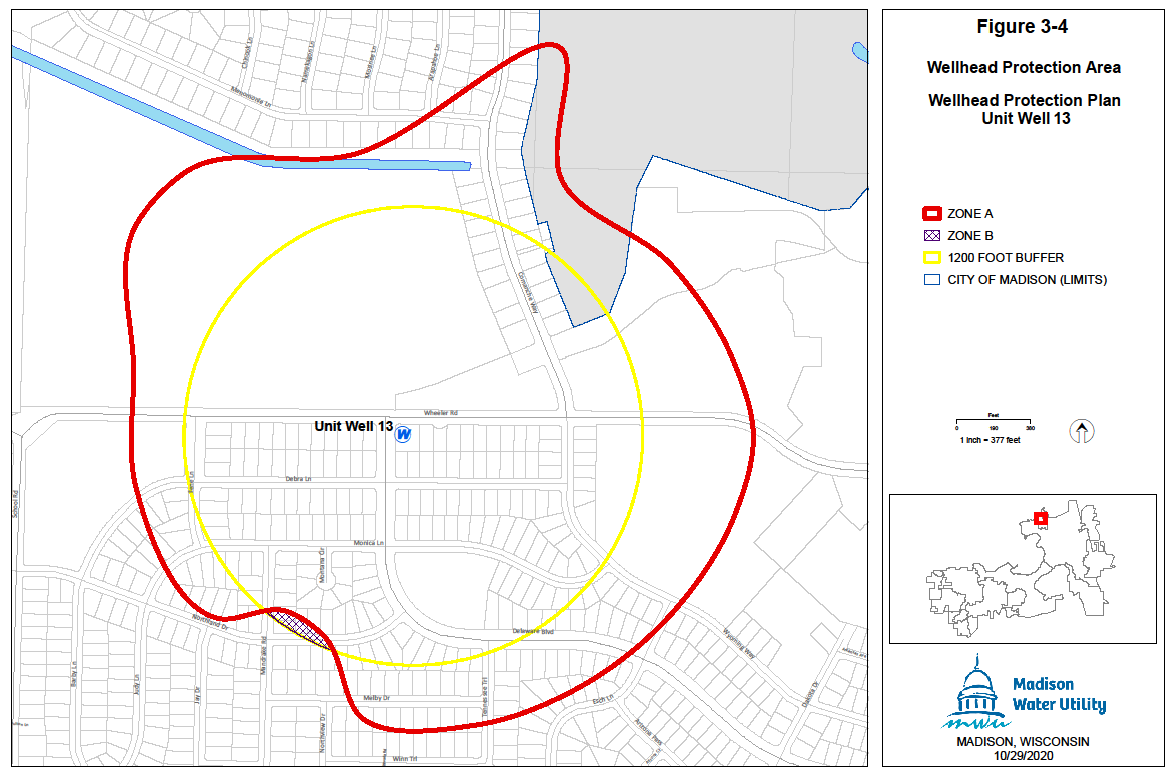
Wellhead Protection District No. 13.
The location of Well No. 13 and the surrounding Zone A and Zone B are shown in Sec. 28.102(12)(a).
(a)
Map of Wellhead Protection District No. 13.
WELL NO. 13
(Am. by ORD-21-00009, 2-10-21)
(13)
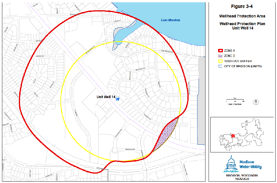
Wellhead Protection District No. 14.
The location of Well No. 14 and the surrounding Zone A and Zone B are shown in Sec. 28.102(13)(a).
(a)
Map of Wellhead Protection District No. 14.
WELL NO. 14
(Am. by ORD-21-00009, 2-10-21)
(14)
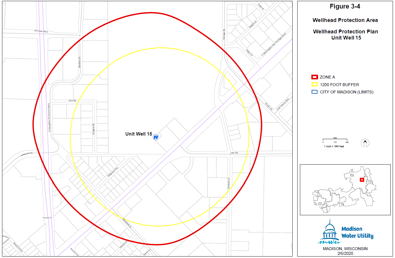
Wellhead Protection District No. 15.
The location of Well No. 15 and the surrounding Zone A and Zone B are shown in Sec. 28.102(14)(a).
(a)
Map of Wellhead Protection District No. 15.
WELL NO. 15
 ;hn2; (Am. by ORD-21-00009, 2-10-21)
(15)
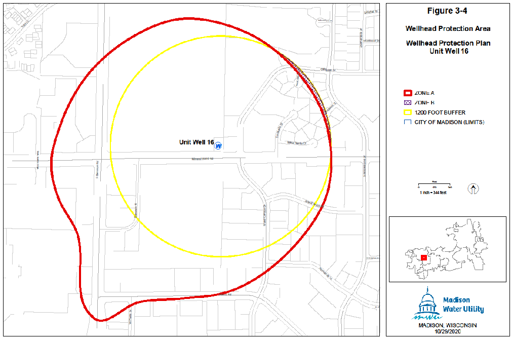
Wellhead Protection District No. 16.
The location of Well No. 16 and the surrounding Zone A and Zone B are shown in Sec. 28.102(15)(a).
(a)
Map of Wellhead Protection District No. 16.
WELL NO. 16
(Am. by ORD-21-00009, 2-10-21)
(16)
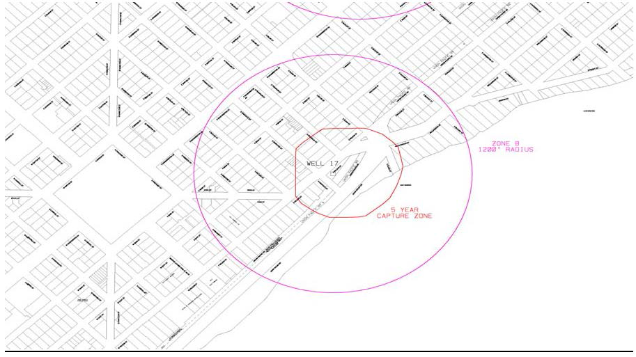
Wellhead Protection District No. 17.
The location of Well No. 17 and the surrounding Zone A and Zone B are shown in Sec. 28.102(16)(a).
(a)
Map of Wellhead Protection District No. 17.
WELL NO. 17
(Am. by ORD-21-00009, 2-10-21)
(17)
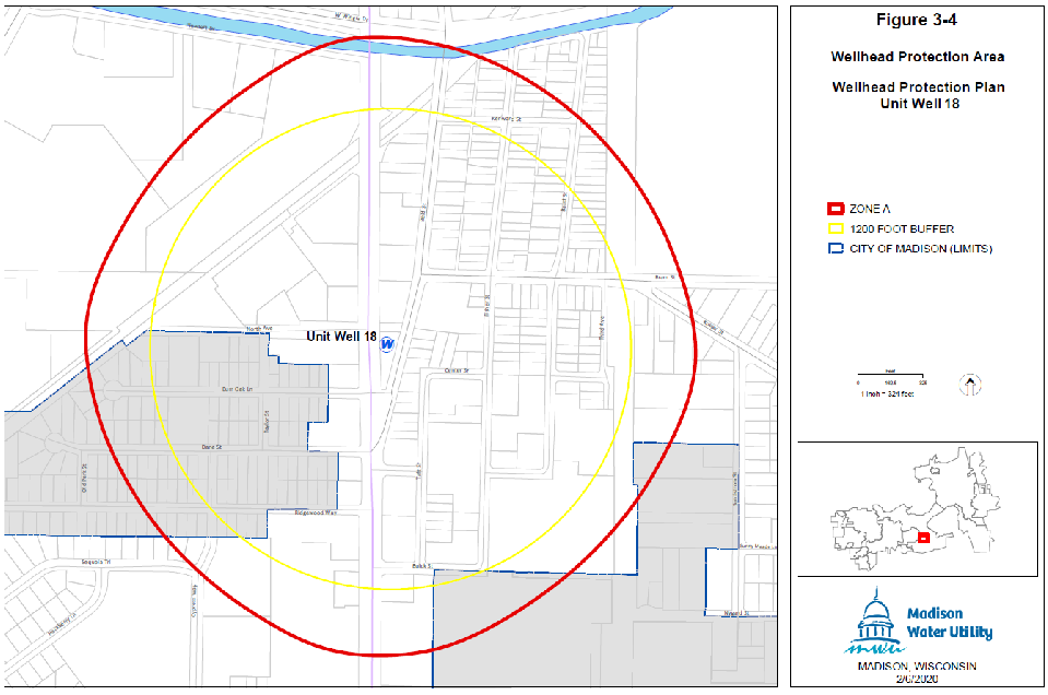
Wellhead Protection District No. 18.
The location of Well No. 18 and the surrounding Zone A and Zone B are shown in Sec. 28.102(17)(a).
(a)
Map of Wellhead Protection District No. 18.
WELL NO. 18
(Am. by ORD-21-00009, 2-10-21)
(18)
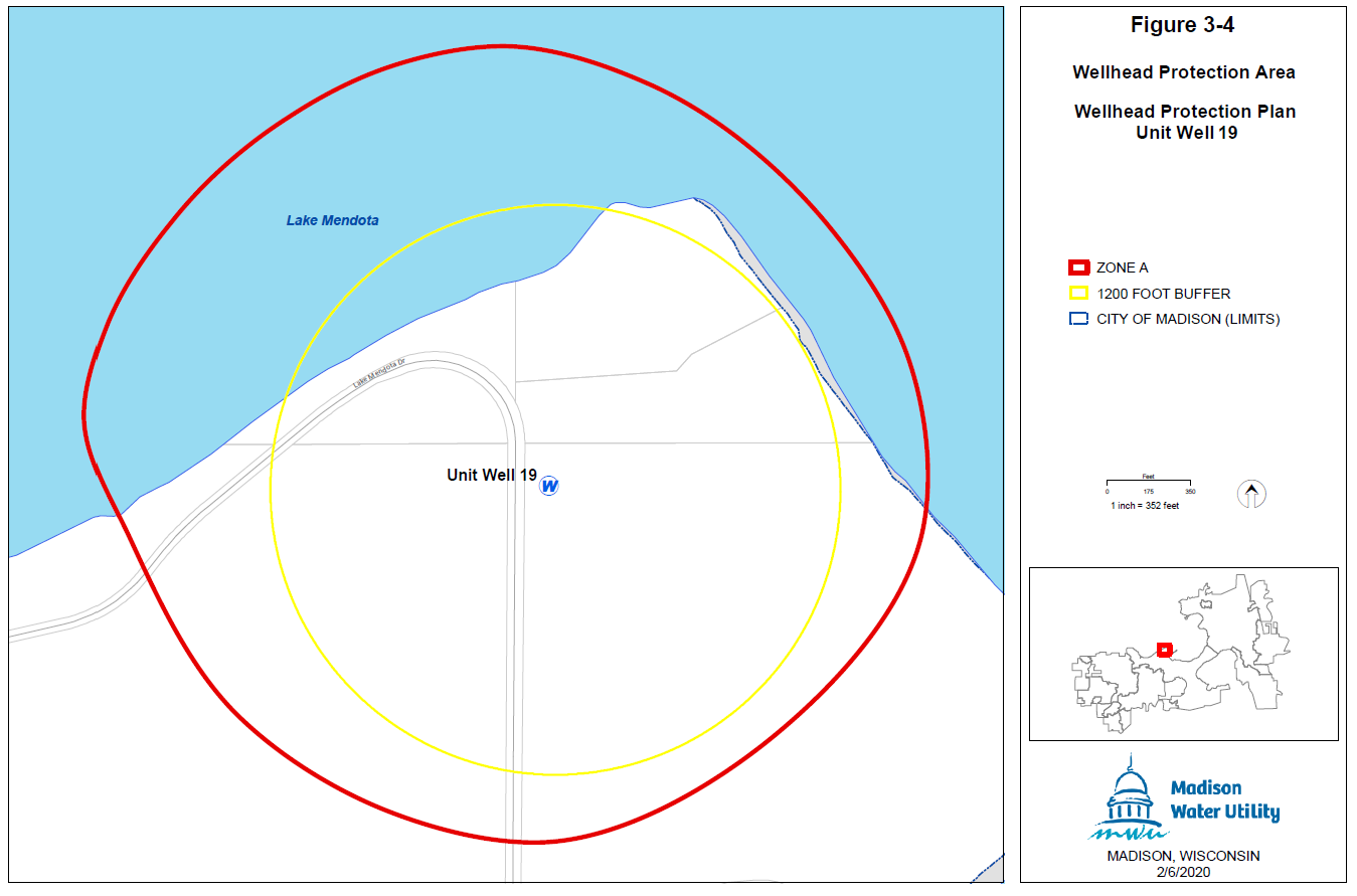
Wellhead Protection District No. 19.
The location of Well No. 19 and the surrounding Zone A and Zone B are shown in Sec. 28.102(18)(a).
(a)
Map of Wellhead Protection District No. 19.
WELL NO. 19
(Am. by ORD-21-00009, 2-10-21)
(19)
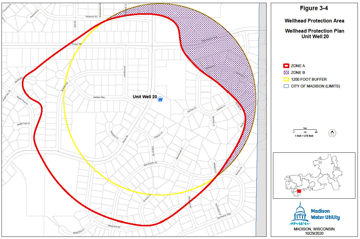
Wellhead Protection District No. 20.
The location of Well No. 20 and the surrounding Zone A and Zone B are shown in Sec. 28.102(19)(a).
(a)
Map of Wellhead Protection District No. 20.
WELL NO. 20
(Am. by ORD-21-00009, 2-10-21)
(20)
Reserved for Future Use. (Rpld. by ORD-21-00009, 2-10-21)
(21)
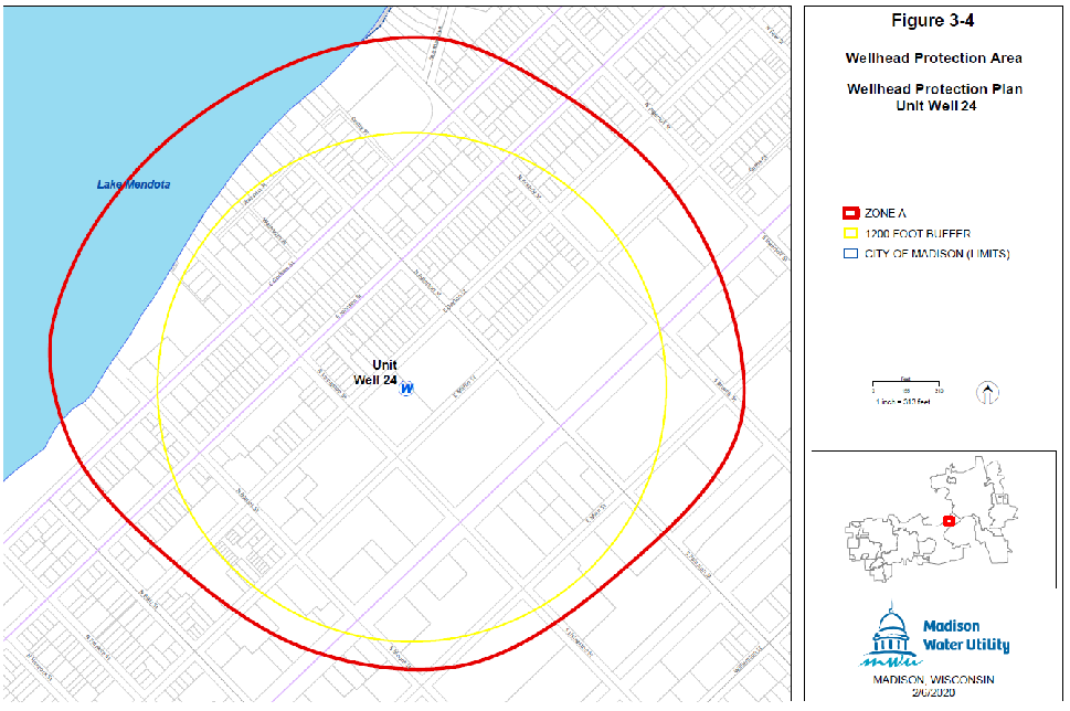
Wellhead Protection District No. 24.
The location of Well No. 24 and the surrounding Zone A and Zone B are shown in Sec. 28.102(21)(a).
(a)
Map of Wellhead Protection District No. 24.
WELL NO. 24
(Am. by ORD-21-00009, 2-10-21)
(22)
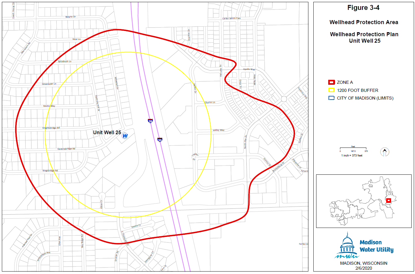
Wellhead Protection District No. 25.
The location of Well No. 25 and the surrounding Zone A and Zone B are shown in Sec. 28.102(22)(a).
(a)
Map of Wellhead Protection District No. 25.
WELL NO. 25
(Am. by ORD-21-00009, 2-10-21)
(23)
Wellhead Protection District No. 26.
The location of Well No. 26 and the surrounding Zone A and Zone B are shown in Sec. 28.102(23)(a).
(a)
Map of Wellhead District No. 26.
WELL NO. 26
(Am. by ORD-21-00009, 2-10-21)
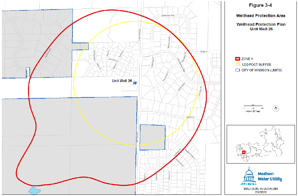
(24)
Wellhead Protection District No. 27.
The location of Well No. 27 and the surrounding Zone A and Zone B are shown in Sec. 28.102(24)(a).
(a)
Map of Wellhead Protection District No. 27.
WELL NO. 27
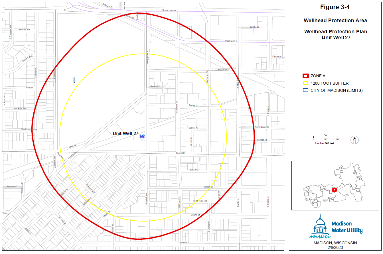 ;hn2; (Am. by ORD-21-00009, 2-10-21)
(25)
Wellhead Protection District No. 28.
The location of Well No. 28 and the surrounding Zone A and Zone B are shown in Sec. 28.102(25)(a).
(a)
Map of Wellhead Protection District No. 28.
WELL NO. 28
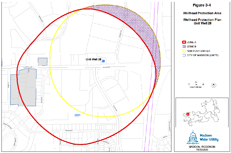 ;hn2; (Am. by ORD-21-00009, 2-10-21)
(26)
Wellhead Protection District No. 29.
The location of Well No. 29 and the surrounding Zone A and Zone B are shown in Sec. 28.102(26)(a).
(a)
Map of Wellhead Protection District No. 29.
WELL NO. 29
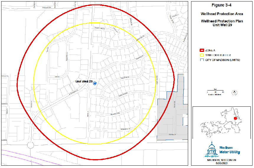
(Am. by ORD-21-00009, 2-10-21)
(27)
Wellhead Protection District No. 30.
The location of Well No. 30 and the surrounding Zone A and Zone B are shown in Sec. 28.102(27)(a).
(a)
Map of Wellhead Protection District No. 30.
WELL NO. 30
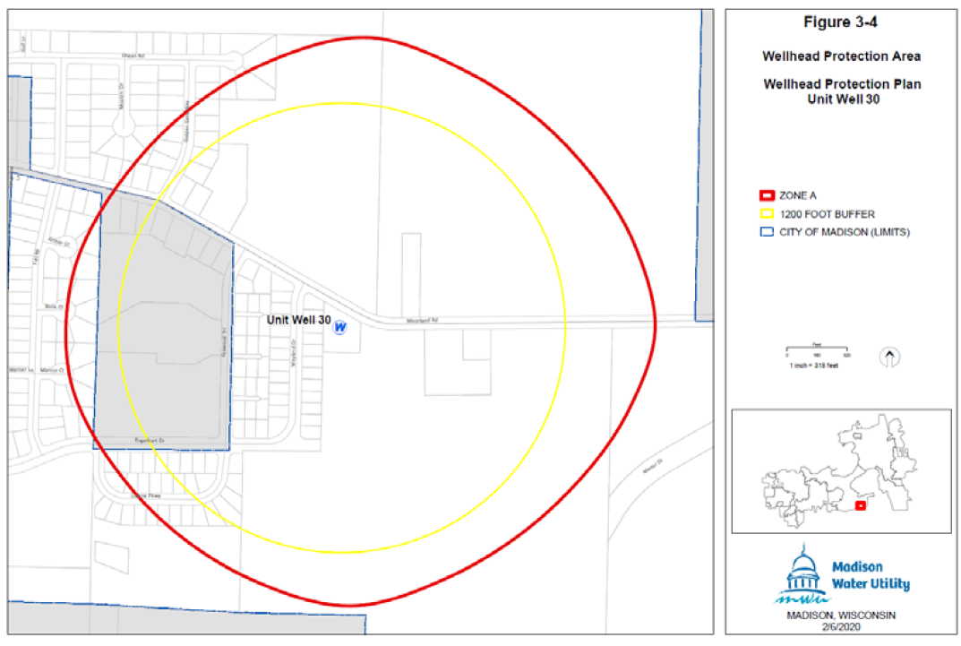
(Am. by ORD-21-00009, 2-10-21)
(28)
Wellhead Protection District No. 31.
The location of Well No. 31 and the surrounding Zone A and Zone B are shown in Sec. 28.102(28)(a).
(a)
Map of Wellhead Protection District No. 31.
(Sec. 28.102(28) Cr. by ORD-15-00098, 9-11-15)
(Sec. 28.102 Am. by ORD-15-00116, 10-28-15)
28.103 - WETLAND OVERLAY DISTRICT.
(1)
Statement of Purpose.
The Wetland Overlay District is established to maintain safe and healthful conditions, to prevent and control water pollution, to protect fish spawning grounds, fish and aquatic life and wildlife habitat, to preserve shore cover and natural beauty and to control building and development in wetlands whenever possible. When development is permitted in a wetland, the development should occur in a manner which minimizes adverse impacts upon the wetland.
(2)
Map Designation.
The Wetland Overlay District is shown on the official zoning district maps identified in Subchapter 28B.
(3)
Permitted Uses.
(a)
The following activities and uses do not require the issuance of a zoning certificate, provided that no wetland alteration occurs:
1.
Hiking, fishing, trapping, swimming and non-motorized boating
2.
Construction and maintenance of duck blinds
(b)
The following activities and uses may involve wetland alterations only to the extent specifically provided below:
1.
The construction and maintenance of piers, docks and walkways, observation decks and trail bridges built on pilings, including limited excavating and filling necessary for such construction or maintenance.
2.
The maintenance, repair, replacement and reconstruction of existing highways and bridges, roads, and electric, telephone, water, gas, sewer and railroad lines, including limited excavating and filling necessary for such maintenance, repair, replacement or reconstruction.
3.
The replacement and reconstruction of existing publicly-owned radio and television towers, provided that neither the existing nor the replaced or reconstructed tower is in a shoreland, as defined in Sec. 28.211.
(4)
Conditional Uses.
The following conditional uses may be allowed in the Wetland Overlay District, including wetland alterations only to the extent specifically provided below. The Southern District Office of the Wisconsin Department of Natural Resources shall be notified of the conditional use proposal at least ten (10) days prior to the hearing and shall be notified of the City's decision within ten (10) days after the decision is made.
(a)
The construction of roads which are necessary for the continuity of the municipal street system, the provision of essential utility and emergency services or to provide access to permitted uses provided that:
1.
The road cannot as a practical matter be located outside the wetland;
2.
The road is designed and constructed to minimize the adverse impact upon the natural functions of the wetland.
3.
The road is designed and constructed with the minimum cross-sectional area practical to serve the intended use.
4.
Road construction activities are carried out in the immediate area of the roadbed only; and
5.
Any wetland alteration must be necessary for the construction or maintenance of the road.
(b)
The construction and maintenance of nonresidential buildings provided that:
1.
The building is used solely in conjunction with a use permitted in the Wetland Overlay District or for the raising of waterfowl, minnows or other wetland or aquatic animals.
2.
The building cannot as a practical matter be located outside the wetland.
3.
The building does not exceed five hundred (500) square feet in floor area; and
4.
No filling, flooding, draining, dredging, ditching, tiling, or excavating is done, except limited filling and excavating necessary for the installation of pilings.
(c)
The establishment and development of public and private parks and recreation areas, natural and outdoor education areas, historic and scientific areas, game and wildlife preserves, fish and wildlife habitat improvement projects, and public boat launching ramps, provided that:
1.
Any private recreation or wildlife habitat area shall be used exclusively for that purpose.
2.
Only that filling and excavating which is necessary for the development of public boat launching ramps, public trails, swimming beaches or the construction of park shelters or similar structures is allowed.
3.
The construction and maintenance of roads necessary for the uses permitted under this paragraph are allowed only where such construction and maintenance meets the standards in Paragraph (4)(a) above.
4.
Ditching, excavating, dredging, dike and dam construction in wildlife refuges, game preserves and private wildlife habitat areas shall only be for the purpose of improving wildlife habitat or otherwise enhancing wetland values.
(d)
The construction and maintenance of electric, gas, telephone, water and sewer transmission and distribution lines and related facilities, provided that:
1.
The transmission and distribution lines and related facilities cannot as a practical matter be located outside the wetland.
2.
Only that filling or excavating which is necessary for such construction or maintenance is allowed; and
3.
Such construction or maintenance is done in a manner designed to minimize the adverse impact upon the natural functions of the wetland.
(e)
The construction and maintenance of railroad lines, provided that:
1.
The railroad lines cannot, as a practical matter, be located outside the wetland.
2.
Only that wetland alteration which is necessary for such construction or maintenance is allowed; and
3.
Such construction or maintenance is done in a manner designed to minimize the adverse impact upon the natural functions of the wetland.
(f)
The harvesting of wild crops, such as marsh hay, ferns, moss, wild rice, berries, tree fruits and tree seeds, in a manner that is not injurious to the natural reproduction of such crops.
(g)
The practice of silviculture, including the planting, thinning and harvesting of timber and limited temporary water level stabilization measures which are necessary to alleviate abnormally wet or dry conditions that would have an adverse impact on the conduct of silvicultural activities if not corrected.
(h)
The pasturing of livestock and the construction and maintenance of fences for such pasturing including limited excavating and filling necessary for such construction or maintenance.
(i)
The cultivation of agricultural crops, if cultivation can be accomplished without filling, flooding, draining, dredging, ditching, tiling, or excavating except limited filling and excavating necessary for the construction and maintenance of fences.
(j)
The maintenance and repair of existing drainage systems to restore pre-existing levels of drainage, including the minimum amount of filling necessary to dispose of dredged spoil, provided that the filling is permissible under Chapter 30, Wis. Stats., and that dredged spoil is placed on existing spoil banks, where possible.
(k)
The installation and maintenance of sealed tiles for the purpose of draining lands outside the Wetland Overlay District provided that such installation or maintenance is done in a manner designed to minimize the adverse impact upon the natural functions of the wetland.
(5)
Prohibited Uses.
Any use not listed in paragraphs (3) or (4) above is prohibited, unless the wetland or a portion of the wetland has been rezoned by amendment of this ordinance in accordance with para. (7) below and the other requirements of this chapter. The use of a boathouse for human habitation and the construction or placement of a boathouse or fixed houseboat below the ordinary high-water mark of any navigable waters are prohibited.
(6)
Development Approvals.
In the Wetland Overlay District, a zoning certificate shall be obtained from the Zoning Administrator before any new development or any change in the use of an existing building, structure or use of land commences. An application for a zoning certificate for lands in the Wetland Overlay District shall include the information required below for a site plan, as well as the specifications and dimensions for any areas of proposed alteration.
(a)
Name, address, and telephone number of applicant, property owner and contractor, where applicable.
(b)
Legal description of the property and a general description of the proposed use or development.
(c)
Whether or not a private water or sewage system is to be installed
(d)
The site plan shall be drawn to scale and submitted as a part of the application form and shall contain the following information:
1.
Dimensions and area of the lot.
2.
Location of any structures with distances measured from the lot lines and centerline of all abutting streets or highways.
3.
Location of any existing or proposed on-site sewage systems or private water supply systems.
4.
Location of the ordinary high water mark of any abutting navigable waterways.
5.
Location and landward limit of all wetlands.
a.
Existing and proposed topographic and drainage features and vegetative cover.
b.
Location of floodplain and floodway limits on the property as determined from floodplain zoning maps used to delineate floodplain areas.
c.
Location of existing or future access roads; and
d.
Specifications and dimensions for areas of proposed wetland alteration.
(7)
Amendment of Wetland Overlay Zoning.
Any amendment to the text or map of the Wetland Overlay District shall comply with Sec. 28.182 and with the following:
(a)
A copy of each proposed text or map amendment shall be submitted to the Southern District Office of the Department of Natural Resources within 5 days of the referral of the proposed amendment to the Plan Commission.
(b)
The Southern District Office of the Department shall be provided with written notice of the public hearing at least ten (10) days prior to such hearing.
(c)
In order to insure that the shoreland protection objectives in Wis. Stat. § 281.31 will be accomplished by the amendment, the Common Council may not rezone a wetland in the Wetland Overlay District, where the proposed rezoning may result in a significant adverse impact upon any of the following:
1.
Storm water and floodwater storage capacity.
2.
Maintenance of dry-season stream flow or the discharge of groundwater to a wetland, the recharge of groundwater from a wetland to another area or the flow of groundwater through a wetland.
3.
Filtering or storage of sediments, nutrients, heavy metals or organic compounds that would otherwise drain into navigable waters.
4.
Shoreline protection against soil erosion.
5.
Fish spawning, breeding, nursery or feeding grounds.
6.
Wildlife habitat; or
7.
Areas of special recreational, scenic or scientific interest, including scarce wetland types and habitat of endangered species.
(d)
Where the Southern District Office of the Department of Natural Resources determines that a proposed rezoning may have a significant adverse impact upon any of the standards listed above, the Department shall notify the City Clerk of its determination either prior to or during the public hearing held on the proposed amendment.
(e)
The Southern District Office of the Department of Natural Resources shall be provided with:
1.
A copy of the recommendations and report of the Plan Commission on the proposed text or map amendment within ten (10) days after the submission of these recommendations to the Common Council; and
2.
Written notices of the Common Council's action on the proposed text or map amendment within ten (10) days after the action is taken.
(f)
If the DNR notifies the Plan Commission in writing that a proposed amendment may have a significant adverse impact upon any of the standards listed in (c) above, that proposed amendment, if approved by the Common Council, may not become effective until more than thirty (30) days have elapsed since written notice of the Common Council approval was mailed to the DNR. If within the thirty (30) -day period the DNR notifies the Common Council that it intends to adopt a superseding wetland zoning ordinance for the City under Wis. Stats. § 62.231(6), the proposed amendment may not become effective until the ordinance adoption procedure under Wis. Stats. § 62.231(6), is complete or otherwise terminated.
(8)
Nonconformities.
Except as provided below, all provisions in Subchapter 28N shall apply.
(a)
Notwithstanding Section 28.191(1)(a), this subchapter does not prohibit the repair, reconstruction, renovation, remodeling, or expansion of a nonconforming structure in existence on the effective date of this ordinance or amendment or of any environmental control facility in existence on May 7, 1982 related to that structure. Wis. Stats. § 28.191(1)(a) shall apply to any environmental control facility that was not in existence on May 7, 1982, but which was in existence on the effective date of this ordinance or amendment. All such work must be done in a manner designed to minimize the adverse impacts upon the natural functions of the wetland.
(b)
If a nonconforming use or the use of a nonconforming structure is discontinued for a period of twelve (12) months, any future use of the property or structure shall conform to the requirements of this ordinance.
(c)
The maintenance and repair of any nonconforming boathouse which extends beyond the ordinary high water mark shall comply with Wis. Stats. § 30.121.
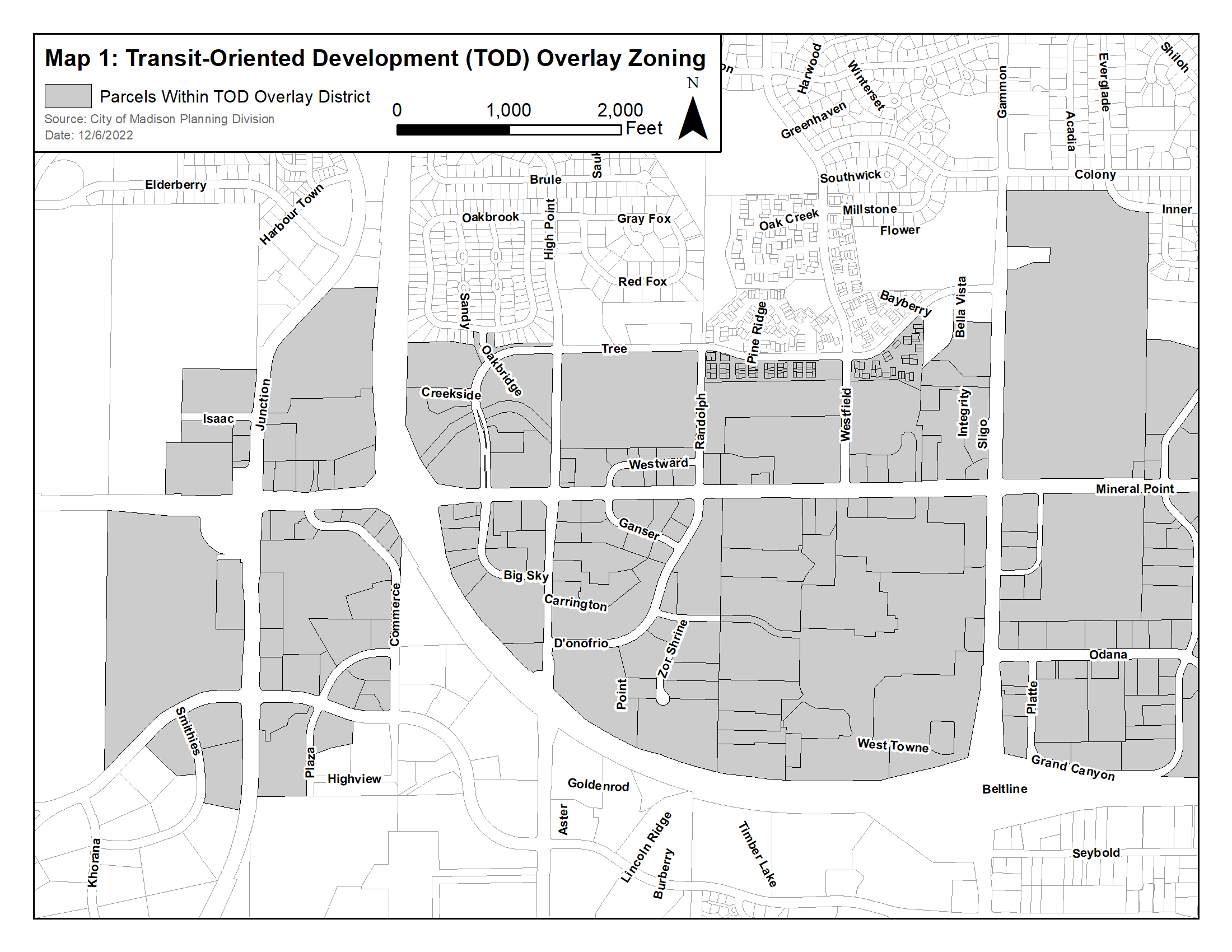
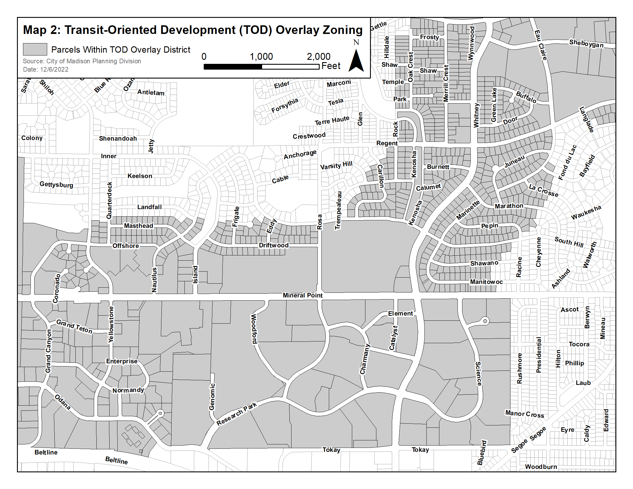
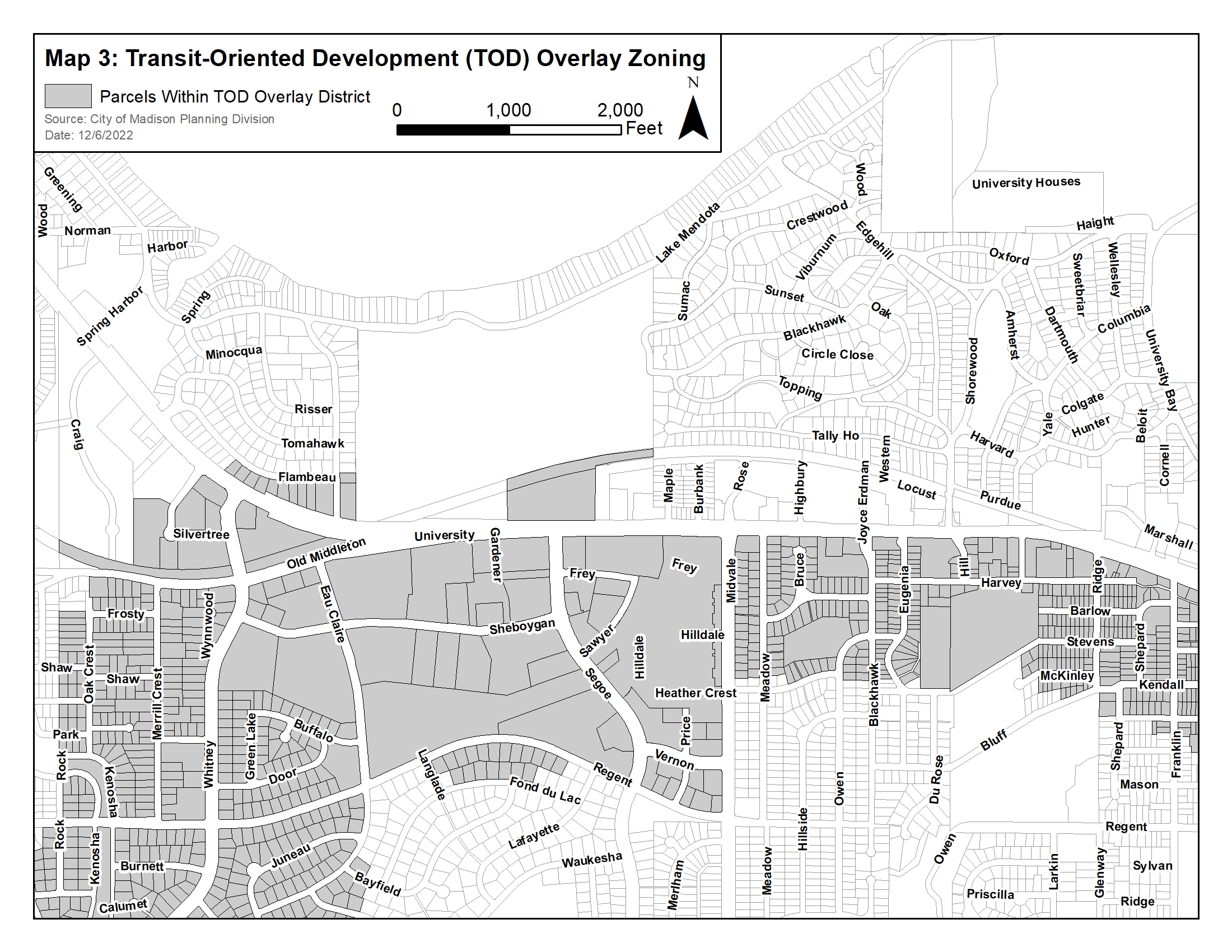
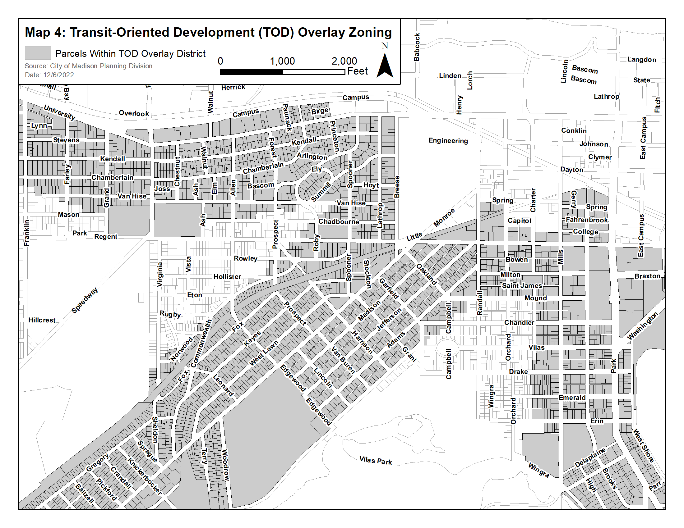
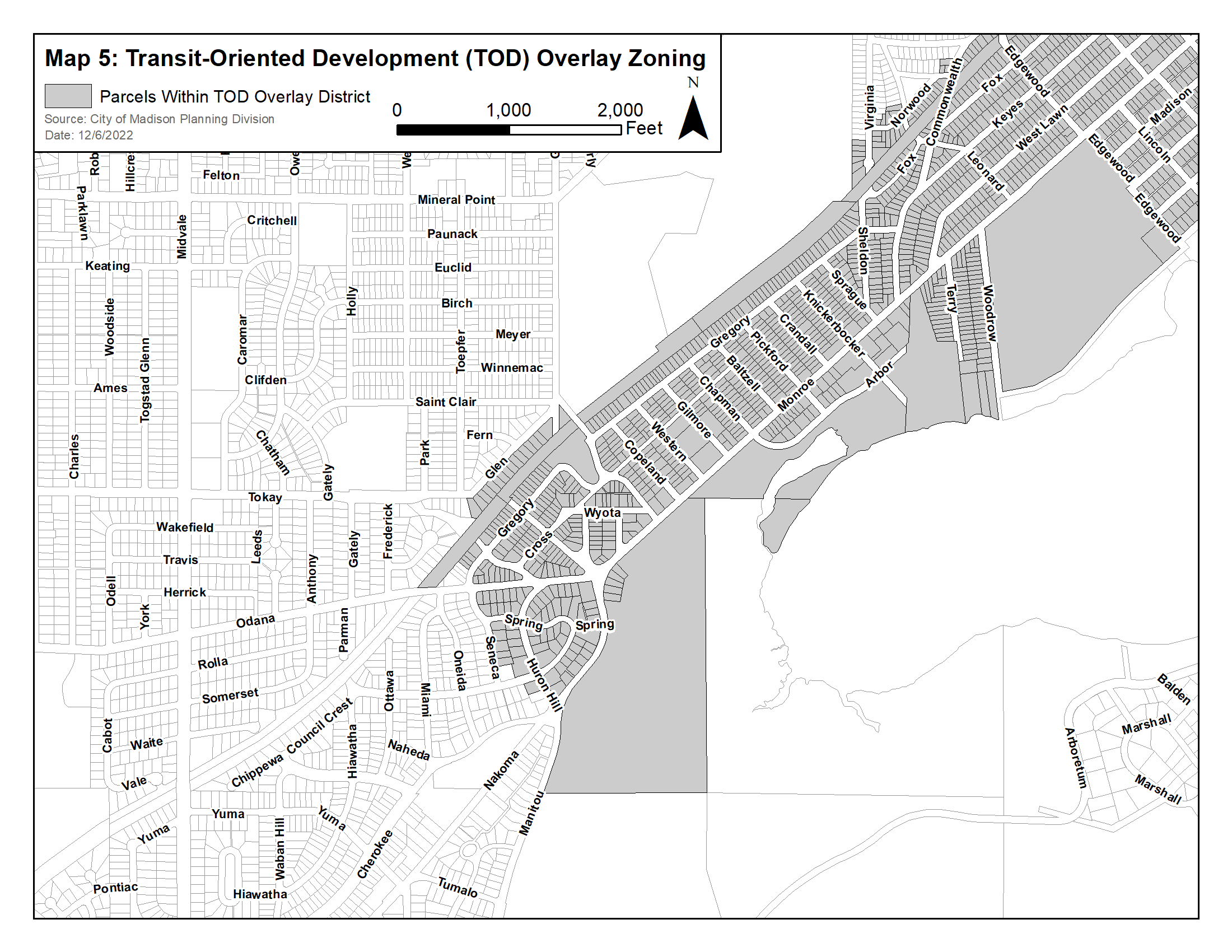
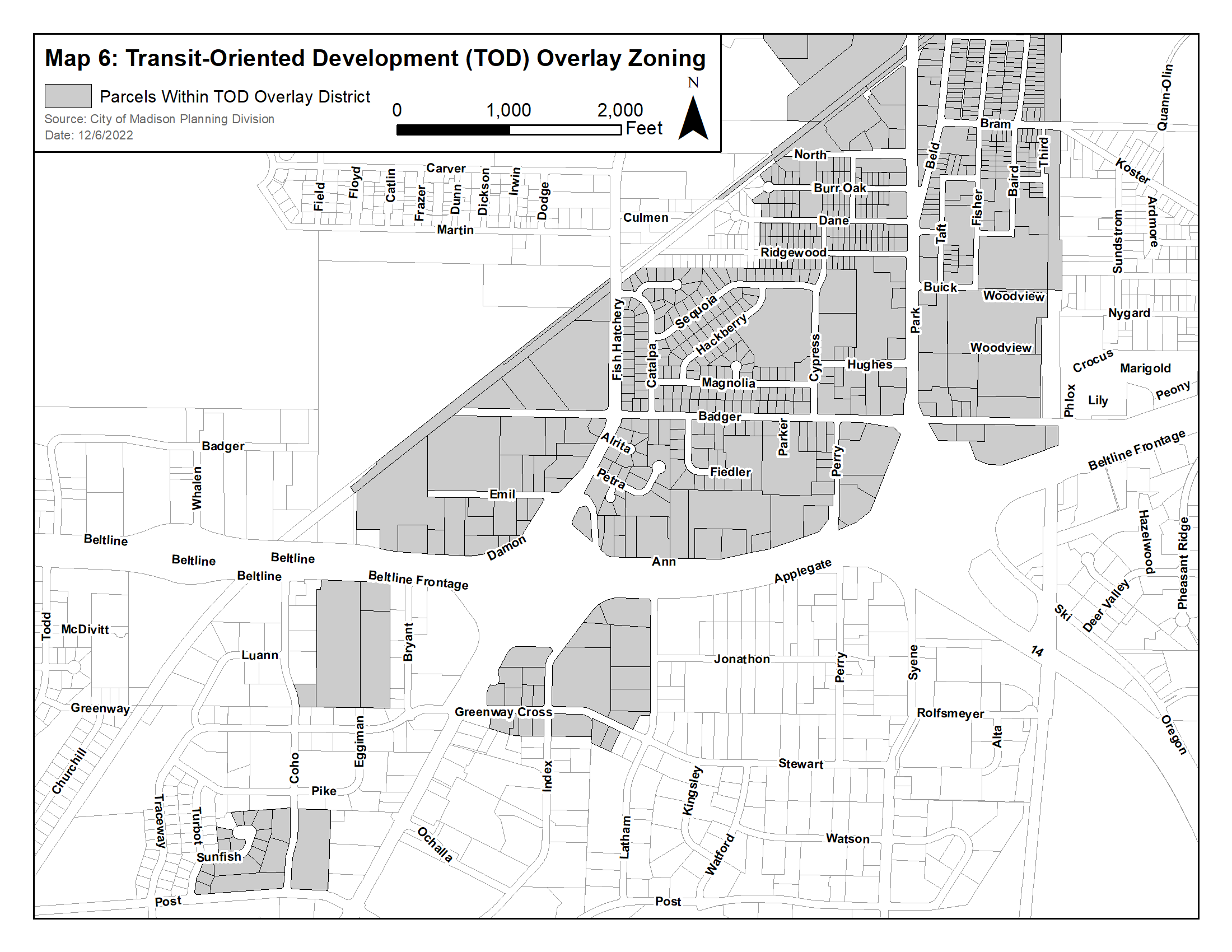
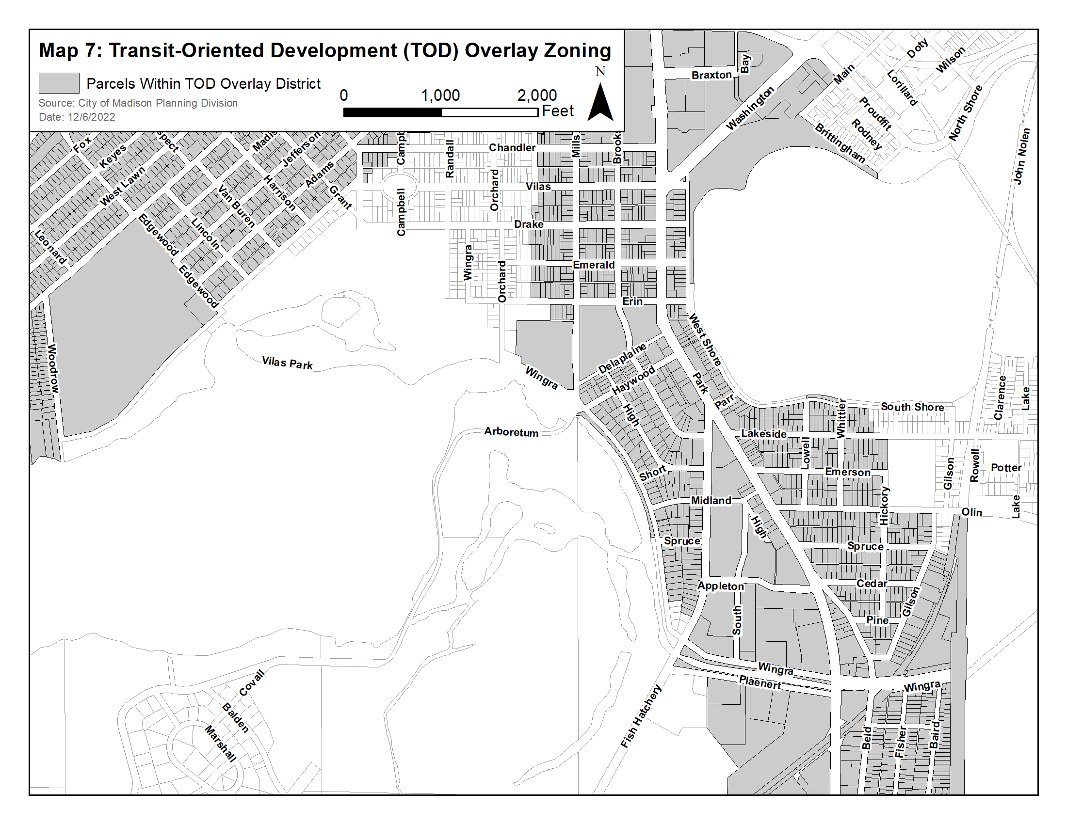
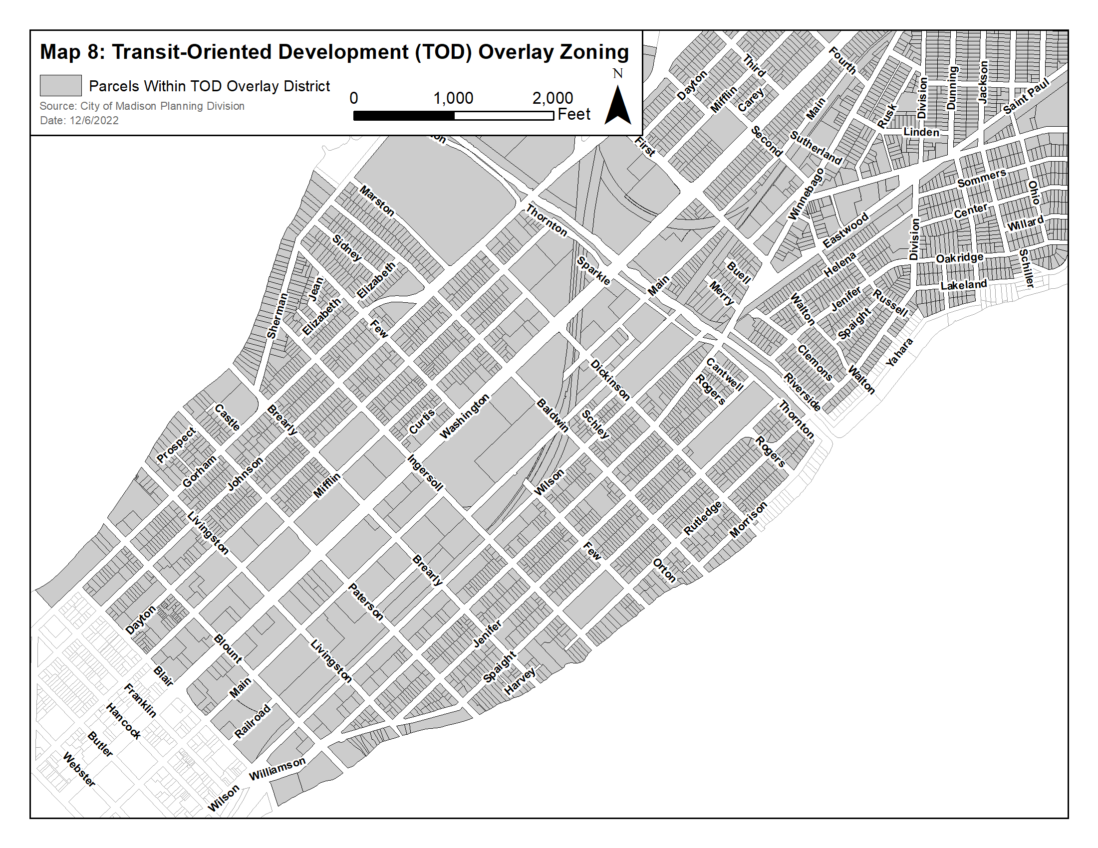
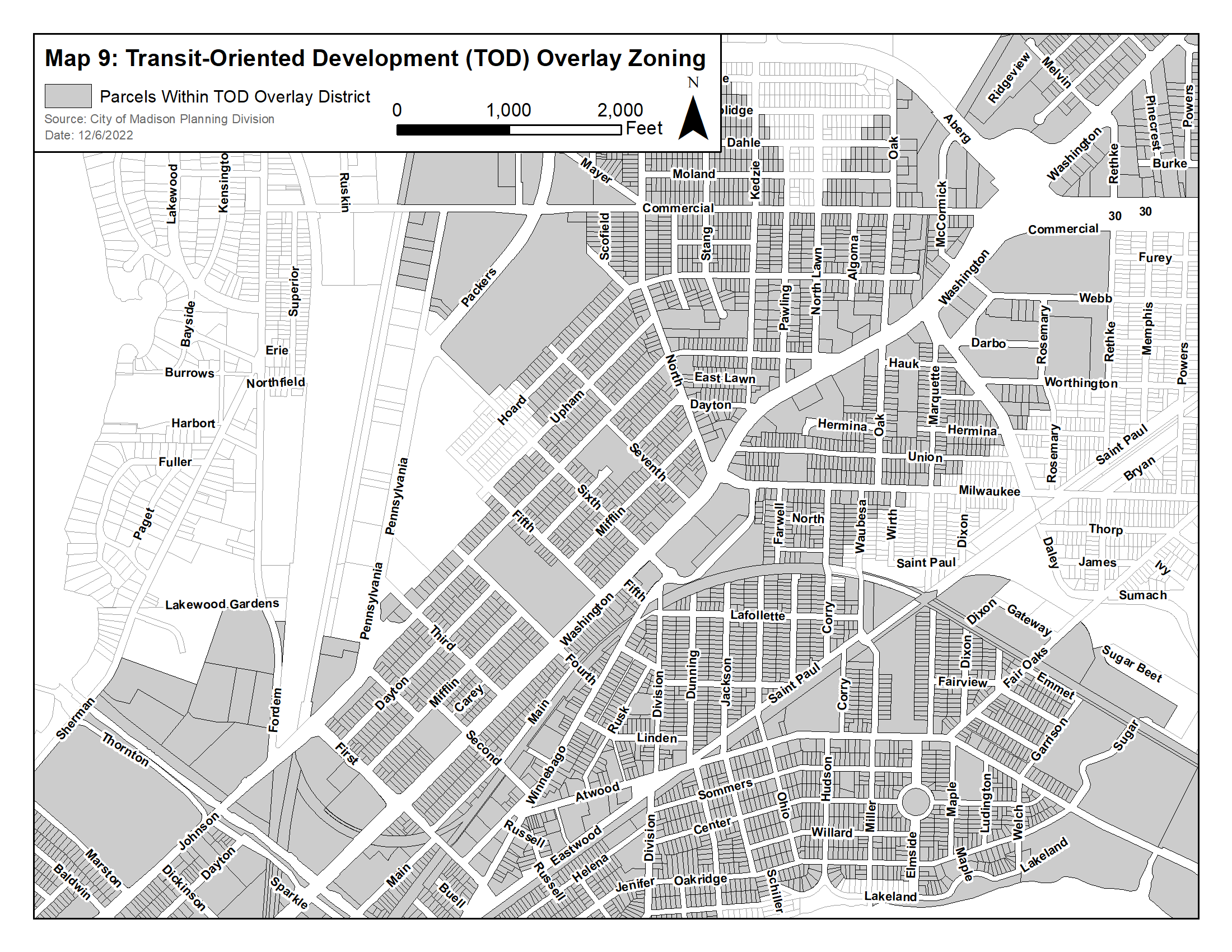
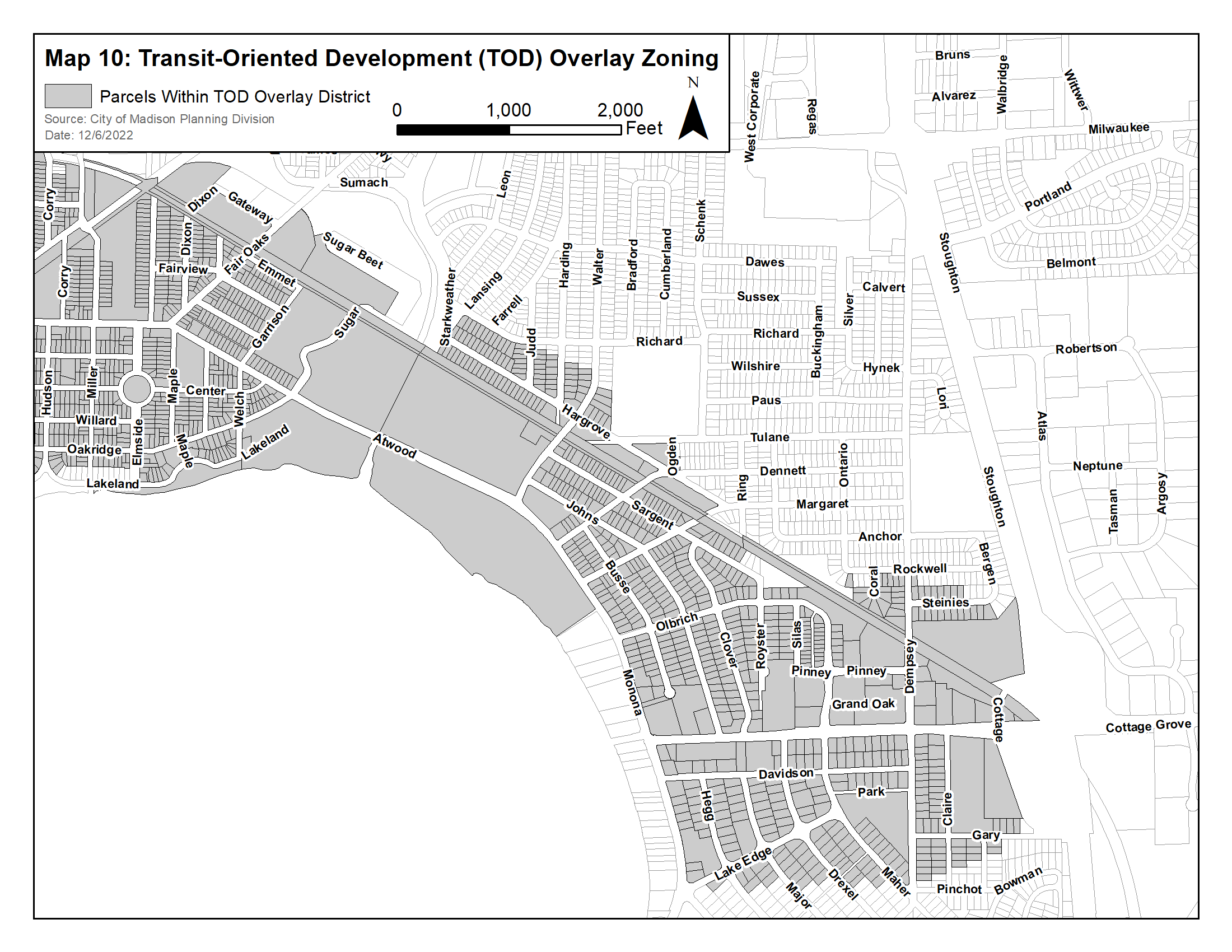
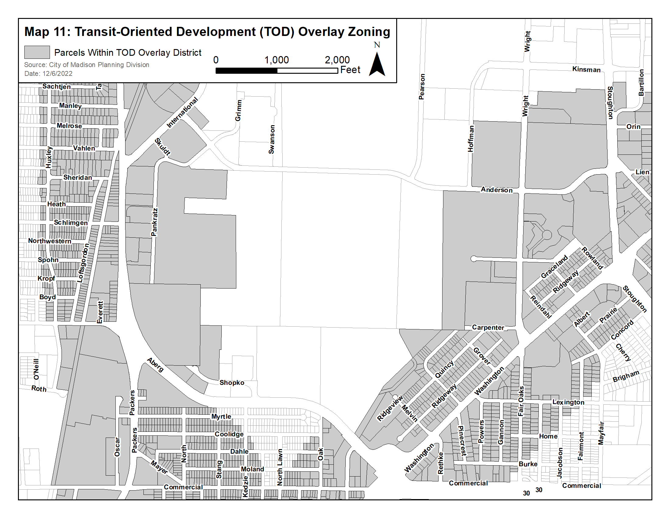
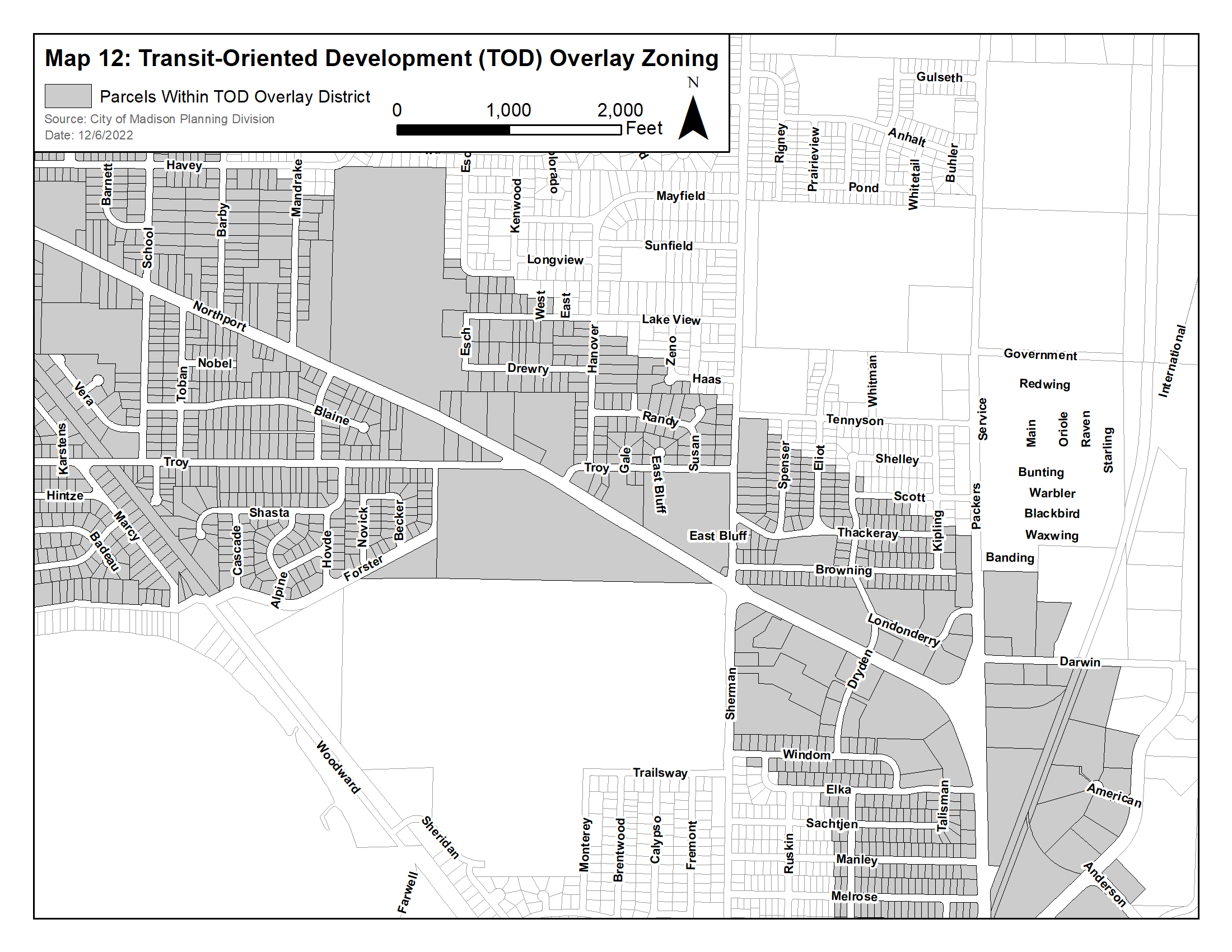
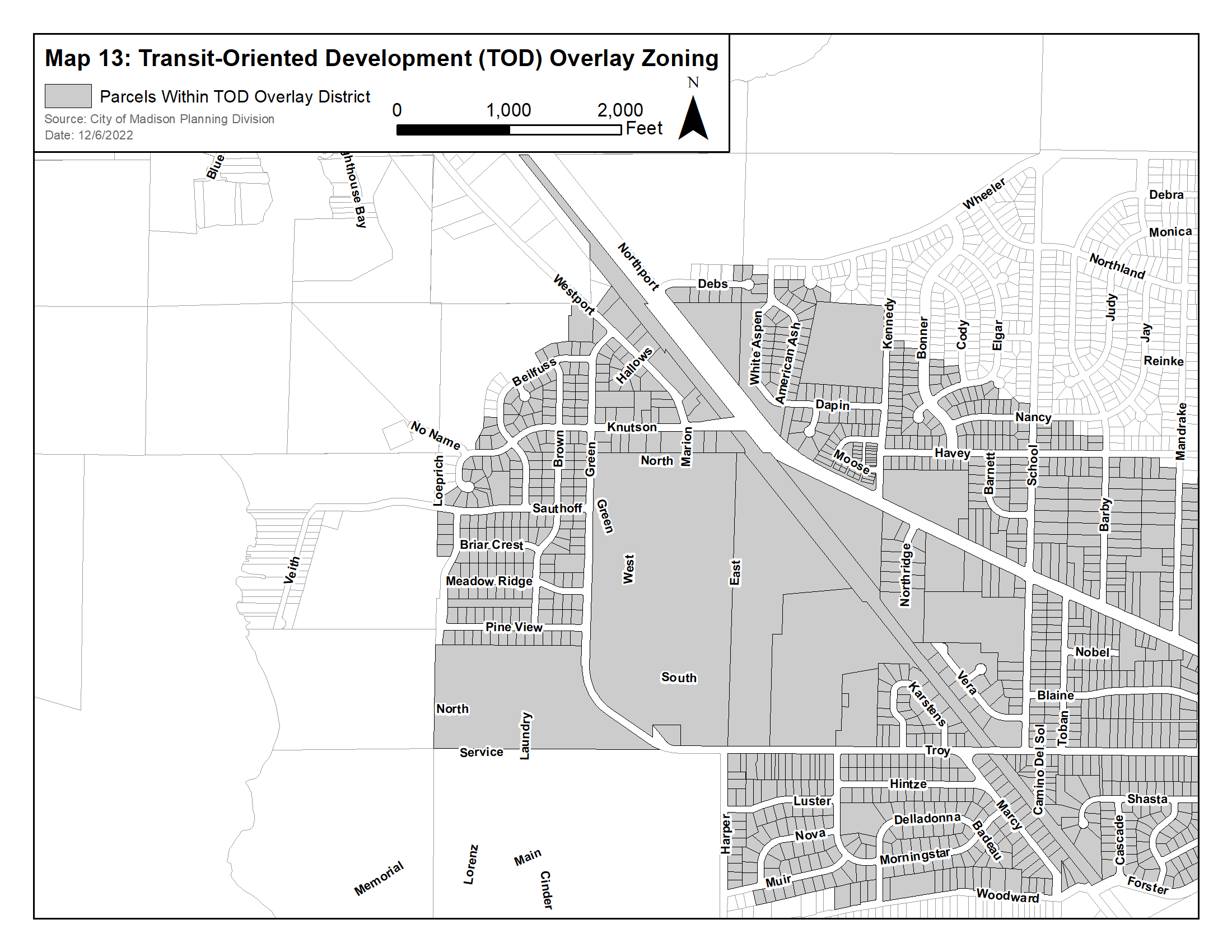
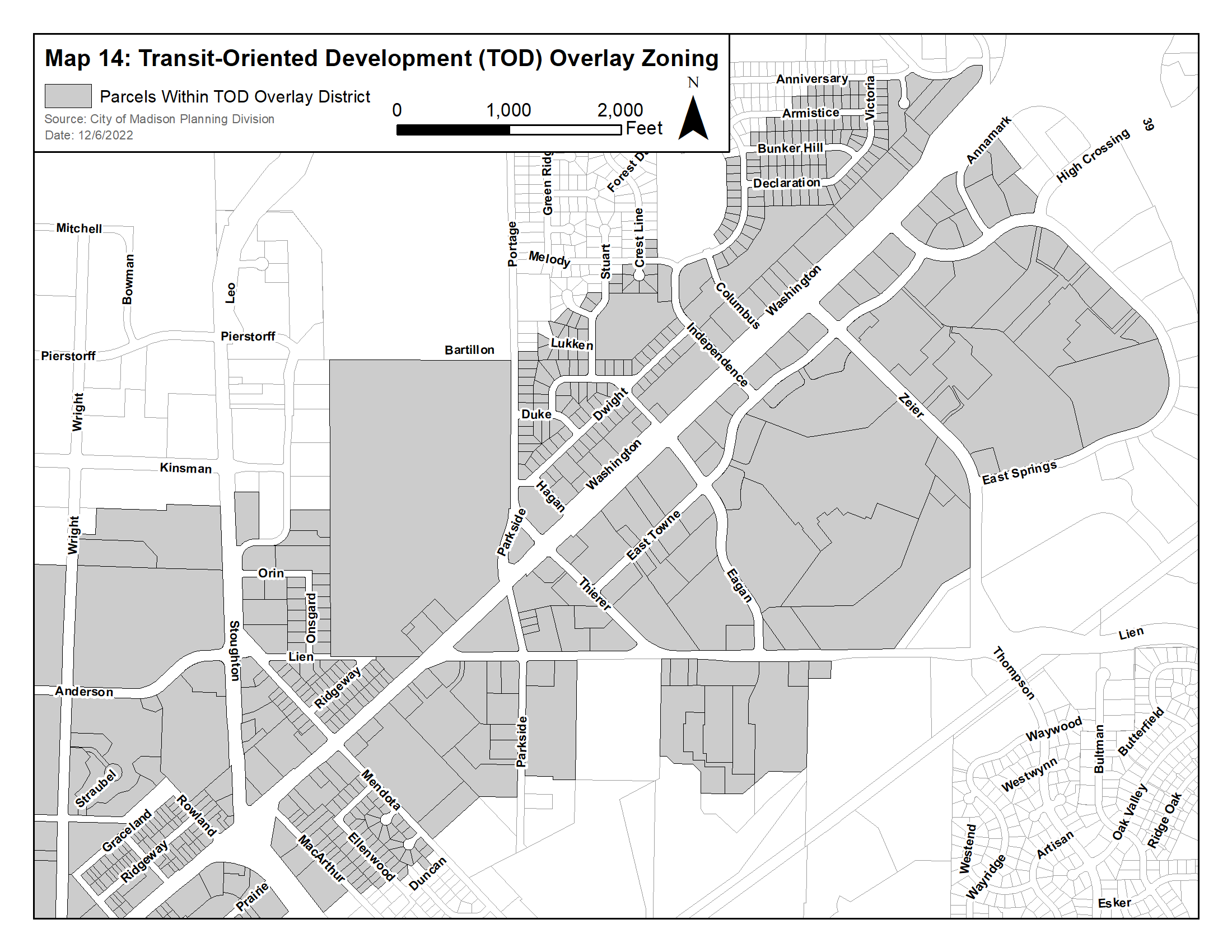
28.104 - TRANSIT ORIENTED DEVELOPMENT OVERLAY DISTRICT.
(1)
Statement of Purpose. The Transit Oriented Development ("TOD") Overlay District is intended to support investment in and use of public transit and bicycle connections. It does this by fostering development that intensifies land use and economic value around transit stations and by promoting a mix of uses that will enhance the livability of station areas.
The district is also intended to:
(a)
Provide increased mobility choices.
(b)
Improve pedestrian connections, traffic and parking conditions.
(c)
Foster high-quality buildings and public spaces that help create and sustain long-term economic vitality.
(2)
Applicability. The TOD Overlay District is depicted on the maps below. This Ordinance applies to all parcels within or partially within boundaries depicted on the map, except development in City of Madison-owned and Dane County-owned parks. (Am. by ORD-23-00071, 8-3-23)
(3)
Residential Districts.
(a)
Permitted and Conditional Uses in Addition to Uses in Base Zoning District.
* (Asterisk) indicates allowable uses changed by the TOD Overlay District.
(b)
Residential District Building Forms.
* (Asterisk) indicates allowable forms changed by the TOD Overlay District.
(c)
Dimensional Requirements, Permitted and Conditional Uses. The following height limits apply to only non-residential uses and buildings with over two residential units.
* (Asterisk) indicates dimensional standards changed by the TOD Overlay District.
(4)
Mixed-Use and Commercial Districts.
(a)
Permitted and Conditional Uses in Addition to Uses in Base Zoning District.
* (Asterisk) indicates allowable uses changed by the TOD Overlay District.
(b)
Dimensional Requirements, Permitted and Conditional Uses.
* (Asterisk) indicates dimensional standards changed by the TOD Overlay District.
(5)
Employment Districts.
(a)
Permitted and Conditional Uses in addition to Uses in Base Zoning District.
* (Asterisk) indicates allowable uses changed by the TOD Overlay District.
(6)
Site Standards for Buildings.
Applicability. The following standards are applicable to all new principal buildings and major expansions [fifty percent (50%) or more of building floor area] for non-residential uses and buildings with over two residential units. Standards shall apply only to the portion of the building that is new or expanded.
(a)
Maximum Principal Building Setbacks.
1.
At least thirty percent (30%) of primary street-facing building facades shall be setback no more than twenty (20) feet from the primary street. Buildings shall occupy at least thirty percent (30%) of the primary street frontage. Setbacks from private streets shall be measured from interior private access road curb faces or edges of pavement.
2.
On a corner lot, at least thirty percent (30%) of street-facing building facades shall be setback no more than twenty (20) feet from the primary street and no more than twenty (20) feet from the secondary street more or less perpendicular to the primary street. Buildings shall occupy at least thirty percent (30%) of the primary street frontage. On lots with more than one corner, only the corner with the primary and secondary streets shall be required to meet this provision. Setbacks from private streets shall be measured from interior private access road curb faces or edges of pavement.
3.
When more than one principal building is developed on a zoning lot, additional buildings shall be exempt from the maximum setback requirement if approved and constructed concurrently with or after a principal building or buildings that:
i.
Comply with the maximum building setback requirements; and
ii.
Occupy at least thirty percent (30%) of each street frontage of the zoning lot. This percentage may be reduced to allow the minimum width for vehicular ingress and egress.
(b)
Entrance Orientation. Principal building entrances on all new buildings shall be oriented to their primary abutting street and be located within the maximum setback. The entrance shall have a functional, operable door and remain open to the public during the same hours as all other public building entrances. Additionally, secondary entrances may be oriented to a secondary street or parking area. Entrances shall be barrier-free, clearly visible and identifiable from the street, and delineated with elements such as roof overhangs, recessed entries, landscaping or similar design features. For buildings with multiple non-residential tenants, a minimum of one (1) tenant space shall have an entrance that meets these requirements. Other tenant spaces shall be connected to the street with a private sidewalk connection.
(c)
Minimum Number of Stories and Height. A minimum of two stories is required for a minimum of seventy-five percent (75%) of the building footprint except for the following uses:
1.
Greenhouse, nursery.
2.
Place of worship.
3.
Public safety or service facilities.
4.
Recreation, community, and neighborhood centers.
5.
Transit station, transfer point.
6.
Counseling/Community Service Organization, when located in an employment district. (Cr. by ORD-23-00070, 8-3-23)
(7)
Site Standards for Automobile Infrastructure.
(a)
Applicability. The following standards are applicable to non-residential uses, and buildings with over three (3) residential units when there is a new principal building or when there is a major expansion [fifty percent (50%) or more of building floor area] of a principal building. Additionally, new automobile infrastructure must comply and no increase in the nonconformity of existing automobile infrastructure is permissible.
(b)
If located on the surface, automobile infrastructure must meet the following standards.
1.
Automobile infrastructure shall not be located between the primary public or private street and the plane of the principal building's primary street-facing facade except for a driveway more or less perpendicular to the corresponding building street-facing facade, connecting directly from the street to other automobile infrastructure located in an allowable location.
2.
On a corner lot, automobile infrastructure shall not be located between the primary street and the plane of the principal building's primary street- facing facade and shall not be located between the secondary public or private street more or less perpendicular to the primary street and the plane of the secondary street-facing facade except for a driveway more or less perpendicular to the corresponding building street-facing facade, connecting directly from the street to other automobile infrastructure located in an allowable location. On lots with more than one corner, only the corner with the primary and secondary (public or private) streets shall be required to meet this provision.
3.
Automobile infrastructure shall be setback from the primary and secondary street equal to or greater to than the principal building setback.
(c)
Drive-through windows shall be located fully under an occupiable conditioned story.
(d)
When there is a drive-through window as part of the building, the building shall have commercial or residential uses as allowed in the base district along the primary street frontage.
(e)
Parking structures shall integrate active uses along at least fifty percent (50%) of the primary street-facing façade at the first floor.
(Am. by ORD-24-00033, 6-3-24)
(Am. by ORD-22-00096, 9-15-22; Rpld. and Recr. by ORD-23-00013, 1-25-23; Am. by ORD-25-00011, 3-8-25)
28.105 - NEIGHBORHOOD CONSERVATION OVERLAY DISTRICTS.
(1)
Statement of Purpose.
Madison is endowed with many distinctive neighborhoods. Recognizing that these neighborhoods contribute significantly to the character and identity of Madison, the City seeks to conserve these areas as a matter of policy. The Neighborhood Conservation District Ordinance is a means to conserve the essential physical character of these neighborhoods.
By establishing a Neighborhood Conservation District, and tailoring the regulations to the attributes of the built environment that make the place distinctive, neighborhoods can prevent insensitive development, and promote better harmony between new and existing structures. This ordinance enables neighborhoods to conserve and enhance the physical characteristics that come together to produce a distinctive environment.
(2)
Applicability.
(a)
The requirements of the Neighborhood Conservation Overlay Districts apply to all development, exterior alterations, additions and demolitions of structures on all zoning lots located in such districts, in addition to all requirements of the underlying primary zoning districts.
(b)
In the event of a conflict between the provisions of the Neighborhood Conservation Overlay Districts and the underlying primary zoning district, the provisions of the Neighborhood Conservation Overlay Districts shall apply.
(3)
Eligibility Criteria.
To be considered for designation as a Neighborhood Conservation District, an area shall meet the following minimum criteria:
(a)
The proposed area includes at least eight (8) contiguous block-faces or two thousand, six hundred forty (2,640) lineal feet of contiguous street frontage.
(b)
The proposed area possesses consistent, identifiable built or natural environment characteristics to be conserved.
(c)
At least seventy-five percent (75%) of the lots in the proposed district have been developed with a principal structure for at least twenty-five (25) years.
(d)
The proposed requirements for a Neighborhood Conservation District are consistent with the Comprehensive Plan and existing neighborhood plans.
(e)
The proposed area contains at least one of the following features:
1.
Distinctive building attributes: scale, mass, distinctive architectural characteristics, e.g., front porches, height, roof styles.
2.
Distinctive land use patterns: mixed uses, parks/open spaces, or unique uses or activities.
3.
Distinctive streetscape characteristics: lighting, street layout, materials, and landscaping.
4.
Distinctive lot features: lot layouts and sizes, setbacks, alleys, and landscaping.
(f)
A Neighborhood Conservation Overlay District shall not be placed in an existing local historic district or Urban Design District.
(4)
Designation Process.
(a)
All requests for creation of a Neighborhood Conservation District shall be initiated by a resident, owner, or commercial tenant and shall be submitted to the Director of the Department of Planning and Community and Economic Development.
(b)
The Director of the Department of Planning and Community and Economic Development shall determine whether the proposed area is consistent with the eligibility standards in Sec. 28.105(3).
(c)
If the proposed Neighborhood Conservation District is consistent with Sec. 28.105(3), notice of an informational meeting regarding the District designation process shall be sent to all owners and occupants of the proposed District.
(d)
Within thirty (30) days of the informational meeting, a survey shall be sent to all owners and occupants of the proposed District regarding the desirability of the proposed District. If more than one (1) informational meeting is held, the survey shall be sent within thirty (30) days of the last meeting.
1.
If any property is added to the proposed District prior to the final recommendation of the Plan Commission, the survey shall be sent to all owners and occupants in the area that was added, and the results shall be submitted to the Common Council.
(e)
The Director of the Department of Planning and Community and Economic Development shall prepare a report on the results of the survey. The report shall only include survey responses received within twenty-eight (28) days from the date the survey is mailed shall be included in the report. The report shall be submitted to the Plan Commission and Common Council.
(f)
A resolution authorizing a Neighborhood Conservation Study shall be introduced to the Common Council and referred to the Plan Commission. If authorized by a resolution adopted by the Common Council, a Neighborhood Conservation Study shall be undertaken.
(g)
A Neighborhood Conservation Study shall explore the feasibility and potential benefits of establishing a Neighborhood Conservation District for an area. The study shall be prepared by the Department of Planning and Community and Economic Development, working with the residents, property owners and business representatives of the proposed district.
1.
At the time the Neighborhood Conservation Study is initiated, written notice shall be given to all owners and occupants in the area proposed for study. Because the exact geographic limits of a Neighborhood Conservation District may include properties that were not anticipated to be in the district at the initiation of the study, failure to provide the above notice shall not affect the validity of a Neighborhood Conservation District that is created.
2.
The Department of Planning and Community and Economic Development shall maintain a registry of persons interested in future notification regarding a particular Neighborhood Conservation District.
(h)
A Neighborhood Conservation Study shall include:
1.
Maps indicating the proposed district boundaries, and the land uses within the proposed district.
2.
An identification of the distinctive attributes of the area's built or natural environment to be preserved and enhanced.
3.
An evaluation of the extent to which the objectives of the proposed Neighborhood Conservation District may be achieved through the application of a standard zoning district.
4.
A list of design requirements for the proposed district that will preserve its distinctive character. In addition to the features in (3)(e), above, requirements may include but are not limited to the following:
a.
Setbacks.
b.
Orientation.
c.
Height and width.
d.
Scale and massing.
e.
Architectural features, including but not limited to fenestration, roof pitch, and building materials.
(i)
Creation of a Neighborhood Conservation Overlay District. If a Neighborhood Conservation District is proposed following the completion of the Neighborhood Conservation Study, it shall include the geographic boundaries, and the specific requirements to be used in reviewing development proposals. A Neighborhood Conservation District ordinance shall be considered pursuant to the procedures in Sec. 28.182.
(j)
Every twenty (20) years after the effective date of the ordinance, the Department of Planning and Community and Economic Development shall survey the owners, residents, and commercial tenants and report to the Plan Commission and Common Council on the results of the survey and suggested changes to the ordinance.
28.121—28.125 - RESERVED.
Editor's note— Ord. No. 25-00076, published November 6, 2025, repealed §§ 28.121—28.125, which pertained to floodplain overlay districts; F1 Floodway District; F2 Flood Fringe District; F3 General Floodplain District; F4 Flood Storage District. See Code Comparative Table for complete derivation.
28.126 - NONCONFORMITIES.
(1)
General Floodplain District.
If these standards conform with Wis. Stat. § 62.23(7)(h), they shall apply to all modifications or additions to any nonconforming use or structure and to the use of any structure or premises which was lawful before the passage of this ordinance or any amendment thereto.
(2)
Conditions.
The existing lawful use of a structure or its accessory use which is not in conformity with the provisions of this ordinance may continue subject to the following conditions:
(a)
No modifications or additions to a nonconforming use or structure shall be permitted unless they comply with this ordinance. The words "modification" and "addition" include, but are not limited to, any alteration, addition, modification, structural repair, rebuilding or replacement of any such existing use, structure or accessory structure or use.
(b)
Maintenance is not considered a modification; this includes painting, decorating, paneling and other nonstructural components and the maintenance, repair or replacement of existing private sewage or water supply systems or connections to public utilities. Any costs associated with the repair of a damaged structure are not considered maintenance.
(c)
The construction of a deck that does not exceed two hundred (200) square feet and that is adjacent to the exterior wall of a principal structure is not an extension, modification or addition. The roof of the structure may extend over a portion of the deck in order to provide safe ingress and egress to the principal structure.
(d)
If a nonconforming use or the use of a nonconforming structure is discontinued for twelve (12) consecutive months, it is no longer permitted and any future use of the property, and any structure or building thereon, shall conform to the applicable requirements of this ordinance;
(e)
The City shall keep a record which lists all nonconforming uses and nonconforming structures, their present equalized assessed value, the cost of all modifications or additions which have been permitted, and the percentage of the structure's total current value those modifications represent;
(f)
No modification or addition to any nonconforming structure or any structure with a nonconforming use, which over the life of the structure would be equal to or exceed fifty percent (50%) of its present equalized assessed value, shall be allowed unless the entire structure is permanently changed to a conforming structure with a conforming use in compliance with the applicable requirements of this ordinance. Contiguous dry land access must be provided for residential and commercial uses in compliance with Sec. 28.123(a)3. The costs of elevating the lowest floor of a nonconforming building or a building with a nonconforming use to the flood protection elevation are excluded from the fifty percent (50%) provisions of this paragraph; (Am. by ORD-13-00086, 5-29-13)
(g)
No maintenance to any nonconforming structure or any structure with a nonconforming use, the cost of which would equal or exceed fifty percent (50%) of its present equalized assessed value, shall be allowed unless the entire structure is permanently changed to a conforming structure with a conforming use in compliance with the applicable requirements of this ordinance. Contiguous dry land access must be provided for residential and commercial uses in compliance with Sec. 28.123(3)(a);
(h)
If on a per event basis the total value of the work being done under (d) and (e) equals or exceeds fifty percent (50%) of the present equalized assessed value the work shall not be permitted unless the entire structure is permanently changed to a conforming structure with a conforming use in compliance with the applicable requirements of this ordinance. Contiguous dry land access must be provided for residential and commercial uses in compliance with Sec. 28.123(3)(a);
(i)
Except as provided in subparagraph (j) below, if any nonconforming structure or any structure with a nonconforming use is destroyed or is substantially damaged, it cannot be replaced, reconstructed or rebuilt unless the use and the structure meet the current ordinance requirements. A structure is considered substantially damaged if the total cost to restore the structure to its pre-damaged condition equals or exceeds fifty percent (50%) of the structure's present equalized assessed value.
(j)
For nonconforming buildings that are substantially damaged or destroyed by a nonflood disaster, the repair or reconstruction of any such nonconforming building shall be permitted in order to restore it to the size and use in effect prior to the damage event, provided that the minimum federal code requirements below are met and all required permits have been granted prior to the start of construction.
1.
Residential Structures.
a.
Shall have the lowest floor, including basement, elevated to or above the base flood elevation using fill, pilings, columns, posts or perimeter walls. Perimeter walls must meet the requirements of Sec. 28.121(12)(a).
b.
Shall be anchored to prevent flotation, collapse, or lateral movement of the structure resulting from hydrodynamic and hydrostatic loads, including the effects of buoyancy and shall be constructed with methods and materials resistant to flood damage.
c.
Shall be constructed with electrical, heating, ventilation, plumbing and air conditioning equipment and other service facilities that are designed and/or elevated so as to prevent water from entering or accumulating within the components during conditions of flooding.
d.
In A Zones, obtain, review and utilize any flood data available from a federal, state or other source.
e.
In AO Zones, the lowest floor must meet one of the following requirements, whichever is greater:
i.
At or above the flood protection elevation;
ii.
Two (2) feet above the highest adjacent grade around the structure; or
iii.
The depth as shown on the FIRM.
f.
In AO Zones, shall have adequate drainage paths around structures on slopes to guide floodwaters around and away from the structure.
2.
Nonresidential Structures.
a.
Shall meet the requirements of Sec. 28.126(2)(j).
b.
Shall either have the lowest floor, including basement, elevated to or above the regional flood elevation; or, together with attendant utility and sanitary facilities, shall meet the standards in Sec. 28.121(12)(a).
c.
In AO Zones with no elevations specified, shall have the lowest floor, including basement, meet the standards in Sec. 28.124(3).
(k)
A nonconforming historic structure may be altered if the alteration will not preclude the structures continued designation as a historic structure, the alteration will comply with Sec. 28.122(3), flood resistant materials are used, and construction practices and floodproofing methods that comply with Sec. 28.121(12) are used. Repair or rehabilitation of historic structures shall be exempt from the development standards of 28.126(2)(j)1. if it is determined that the proposed repair or rehabilitation will not preclude the structure's continued designation as a historic structure and is the minimum necessary to preserve the historic character and design of the structure.
(3)
Floodway District.
(a)
Additions or modifications shall not be allowed to any nonconforming structure or any structure with a nonconforming use in the floodway district unless such addition or modification:
1.
Has been granted a permit or variance that meets all ordinance requirements.
2.
Meets the requirements of Section 28.126(1) and (2). (Am. by ORD-13-00086, 5-29-13)
3.
Shall not increase the obstruction to flood flows or regional flood height; and
4.
Any addition to the existing structure shall be floodproofed, pursuant to Sec. 28.121(12), by means other than the use of fill, to the flood protection elevation; and
5.
If any part of the foundation below the flood protection elevation is enclosed, the following standards shall apply:
a.
The enclosed area shall be designed by a registered architect or engineer to allow for the efficient entry and exit of the flood waters without human intervention. A minimum of two (2) openings must be provided with a minimum net area of at least one (1) square inch for every one (1) square foot of the enclosed area. The lowest part of the opening can be no more than twelve (12) inches above the adjacent grade.
b.
The parts of the foundation located below the flood protection elevation must be constructed of flood-resistant materials.
c.
Mechanical and utility equipment must be elevated or floodproofed to or above the flood protection elevation; and
d.
The use must be limited to parking, building access or limited storage.
(b)
No new on-site sewage disposal system, or addition to an existing on-site sewage disposal system, except where an addition has been ordered by a government agency to correct a hazard to public health, shall be allowed in the Floodway District. Any replacement, repair or maintenance of an existing on-site sewage disposal system in the Floodway District shall meet the applicable requirements of all municipal ordinances and Wis. Admin. Code ch. SPS 383.
(c)
No new well or modification to an existing well, used to obtain potable water, shall be allowed in the Floodway District. Any replacement, repair or maintenance of an existing well in the Floodway District shall meet the applicable requirements of all municipal ordinances and Wis. Admin. Code chs. NR 811 and NR 812.
(4)
Flood Fringe District.
(a)
The provisions of Sec. 28.126(1) and (2) shall apply to all nonconforming uses and structures.
(b)
Additions or modifications shall not be allowed to any nonconforming structure or any structure with a nonconforming use unless such addition or modification has been granted a permit or variance. In addition, the addition or modification shall meet the requirements of Subdivision 28.123(3) above except where Paragraph (c) below is applicable.
(c)
Where compliance with the provisions of Paragraph (b) above would result in unnecessary hardship, and only where the structure will not be used for human habitation or be associated with a high flood damage potential, the Zoning Board of Appeals may grant a variance from those provisions of Paragraph (a) above for additions or modifications using the criteria listed below. Additions or modifications which are protected to elevations lower than the flood protection elevation may be permitted provided:
1.
No floor is allowed below the regional flood elevation for structures with residential or commercial uses.
2.
Human lives are not endangered.
3.
Public facilities, such as water or sewer, shall not be installed.
4.
Flood depths shall not exceed two (2) feet.
5.
Flood velocities shall not exceed two (2) feet per second; and
6.
The structure shall not be used for storage of materials described in Sec. 28.123(3)e.
(d)
All new private sewage disposal systems, or addition to, replacement, repair or maintenance of a private sewage disposal system shall meet all the applicable provisions of all local ordinances and Wis. Admin. Code ch. SPS 383.
(e)
All new wells, or addition to, replacement, repair or maintenance of a well shall meet the applicable provisions of this ordinance and Wis. Admin. Code chs. NR 811 and NR 812.
(5)
Nonconformities in Flood Storage Areas.
No modifications or additions shall be allowed to any nonconforming structure in a flood storage district unless the standards in Sec. 28.125 (1) and (2) are met. (Am. by ORD-13-00086, 5-29-13)
(Sec. 28.126 Am. by ORD-14-00146, 9-12-14)
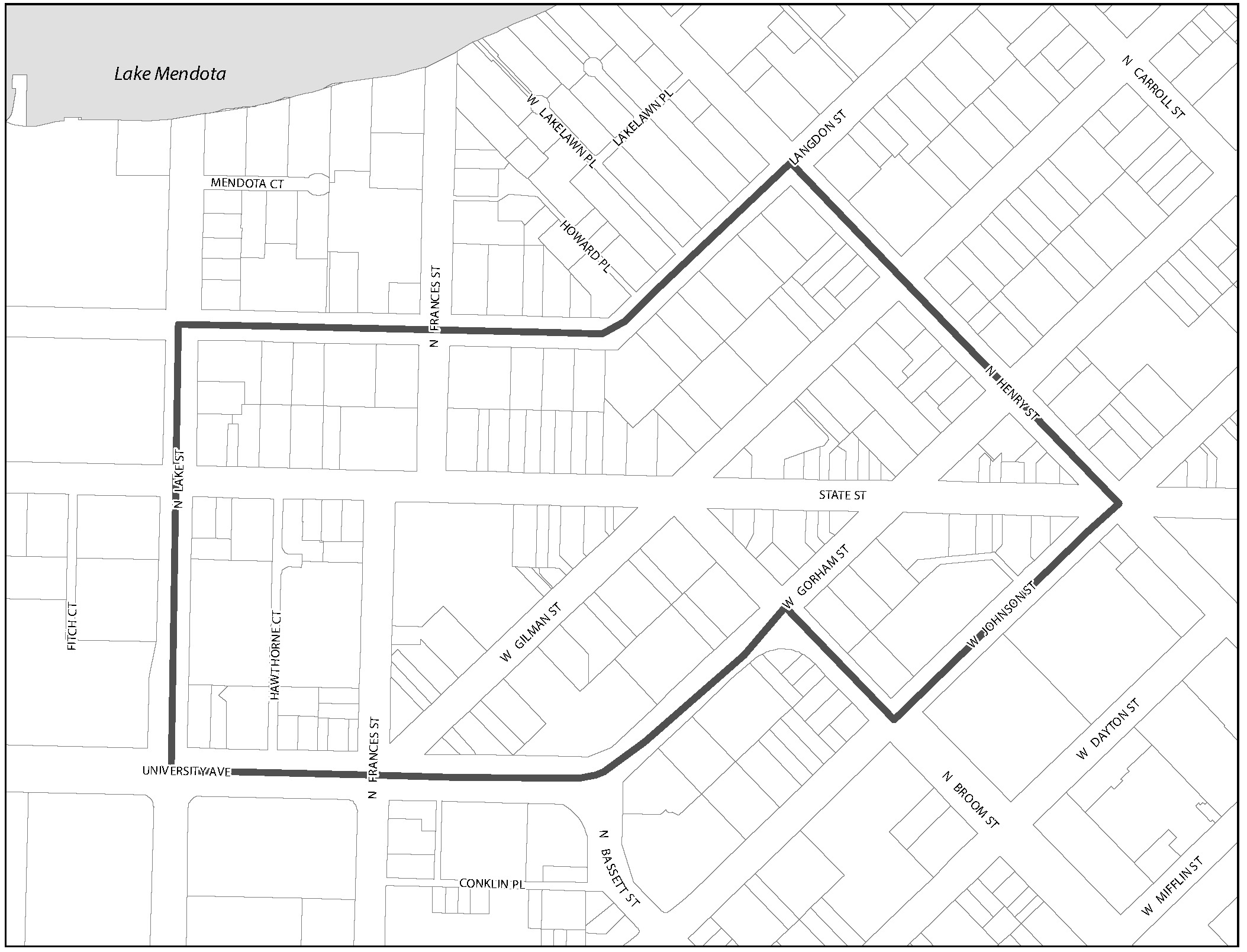
28.127 - ALCOHOL OVERLAY DISTRICT.
(1)
Applicability. The Alcohol Overlay district is depicted on the map below. This ordinance applies to all addresses within the boundaries depicted on the map.
(a)
Alcohol Overlay District map.
(2)
Permitted and Conditional Uses. Table 28H-1 lists permitted and conditional uses in the Alcohol Overlay District which supersede the regulations in the underlying zoning district.
(a)
"P" means permitted in the districts where designated.
(b)
"C" means allowed as conditional uses in the districts where designated, in compliance with all applicable standards.
(c)
"P/C" means permitted or conditional, depending on specific requirements in Supplemental Regulations, Sec. 28.151. (Am. by ORD-22-00096, 9-15-22)
(d)
"Y" means there are specific requirements in Sec. 28.151 associated with the use. (Am. by ORD-22-00096, 9-15-22)
Table 28H-1
(Cr. by ORD-14-00083, 4-16-14; Am. by ORD-19-00053, 7-15-19; Am. by ORD-20-00003, 1-16-20; Am. by ORD-20-00016, 2-13-20; Am. by ORD-22-00001, 1-14-22; Am. by ORD-22-00096, 9-15-22; Am. by ORD-25-00042, 6-27-25)