
Montebello City Zoning Code
CHAPTER 17
04 - ZONING DISTRICTS
17.04.010 - Designation.
In order to classify, regulate, restrict and segregate the uses of land and buildings, to regulate and restrict the height and bulk of buildings and to regulate the area of yards and other open spaces about buildings, and to regulate the density of population, twelve classes of zones are by this title established to be as follows:
(Prior code § 9211)
17.04.020 - More restrictive uses defined.
"More restrictive uses" as employed in this title means the following:
A.
Those uses first permitted in the R-1 zone are the more restrictive.
B.
All other uses are less restrictive in the order they are first permitted in the zones, in the sequence shown: R-2, R-3, R-4, C-R, C-1, C-2, C-3, C-M, M-1 and M-2.
C.
Uses permitted in the R-A zone are to be as restrictive as those permitted in the R-1 zone, except that uses pertaining to animals shall not be considered as more restrictive uses for purposes of this title.
(Prior code § 9211.1)
17.04.030 - Location and boundaries.
The location and boundaries of the various zones are shown and delineated on the zoning map of the city, which is made a part of this title by reference as though fully set forth herein.
(Prior code § 9211.2)
17.04.040 - Division of zoning map.
The zoning map may, for convenience, be divided into parts, and each part may, for purposes of more readily identifying areas within the zoning map, be subdivided into units, and these parts and units may be separately employed for purposes of amending the zoning map or for any official reference to the zoning map.
(Prior code § 9211.3)
17.04.050 - Changes in boundaries.
Changes in the boundaries of the zones shall be made by ordinance adopting an amended zoning map, or part of the map, or unit of a part of the zoning map. These maps, when adopted, shall be published in the manner prescribed by law and become a part of this title.
(Prior code § 9211.4)
17.04.060 - Uncertainty of boundaries.
Where uncertainty exists as to the boundaries of any zone shown upon a zoning map or any part or unit, the following rules apply:
A.
Where such boundaries are indicated as approximately following street and alley lines or lot lines, such lines shall be construed to be the zone boundaries.
B.
In the case of unsubdivided property, and where a zone boundary divides a lot, the location of such boundaries, unless the same are indicated by dimensions, shall be determined by use of the scale appearing on the zoning map.
C.
Where a public street or alley is officially vacated or abandoned, the street or alley will acquire the classification of the property to which it reverts.
D.
Areas of dedicated streets or alleys and railroad rights-of-way, other than such as are designated on the zoning map as being classified in one of the zones provided in this title, shall be deemed to be the unclassified and, in the case of streets, permitted to be used for purposes lawfully allowed, and in the case of railroad rights-of-way, permitted to be used solely for the purpose of accommodating tracks, signals, other operative devices and the movement of rolling stock.
(Prior code § 9211.5)
17.04.070 - Classification of annexed lands and unclassified property.
A.
Any property which, for any reason, is not designated on the zoning map or in this title as being classified in any of the zones established herein, shall be deemed to be temporarily zoned R-1 until the land is classified after being processed as an amendment to the zone plan pursuant to this title and Chapter 1, Title 7 of the Government Code.
B.
Areas annexed to the city shall be classified in the zone under this title most comparable to the zone classification for the annexed area in the county at the time of annexation, unless the city council adopts a different classification in the manner provided for zone changes in this title. Such zone changes, variances or conditional use permits may be initiated and heard prior to the effective date of annexation. Any zone changes, variances or conditional use permits granted would be in effect upon annexation.
(Prior code § 9211.6)
17.04.080 - Limitation on land use.
Except as provided in this title, no building shall be erected, reconstructed or structurally altered, nor shall any building or land be used for any purpose except as specifically provided and allowed in the zone in which the building and land are located.
(Prior code § 9211.7)
17.04.090 - Compliance with code requirements.
Compliance with the provisions of the zoning code shall not, in any case, be deemed to be a waiver of the requirements of Chapters 5.04 and 12.16 of this code, or any other provision of the municipal code, requiring the issuance of a license or permit, or both, for the conduct of a business or any other activity.
(Prior code § 9211.8)
17.04.100 - Precedence of approved redevelopment and specific plans.
Whenever any lot in the city has been included within the area of an approved redevelopment plan, or included within the boundaries of a specific plan, adopted pursuant to Section 65450 et seq. of the Planning and Zoning Law of the state, approved redevelopment plans and/or specific plans take precedence over the zoning code where there is a conflict between standards specified in the plan and standards specified in the zoning code.
(Prior code § 9211.9)
17.04.110 - Downtown Code.
4.0 Introduction
The Code will facilitate orderly implementation of the Downtown Vision.
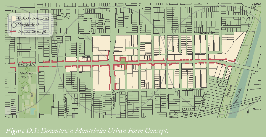
Downtown Montebello provides a range of living, working, and recreational options to suit diverse needs. The form and character of the different human habitats is conceived as a geography of diverse place types such as districts, neighborhoods, and corridors.
The Downtown is built out with commercial and residential areas. Some of the vacant and underutilized sites in the Downtown area offers the greatest potential for preserving commercial development and attracting new growth.
Community preferences and directions throughout the visioning process guide the coding of the built environment — from a broad, citywide scale, to a detailed scale of individual downtown neighborhoods, blocks, buildings and physical character, consistent with the history and desired future of the place.
Many of the downtown improvements will be carried out by the private sector. Providing clear and precise standards promotes objectivity and allows for a streamlined development review process.
This section outlines a number of plans, regulations, processes, and incentives that will be applied in implementing the Downtown Montebello Specific Plan.
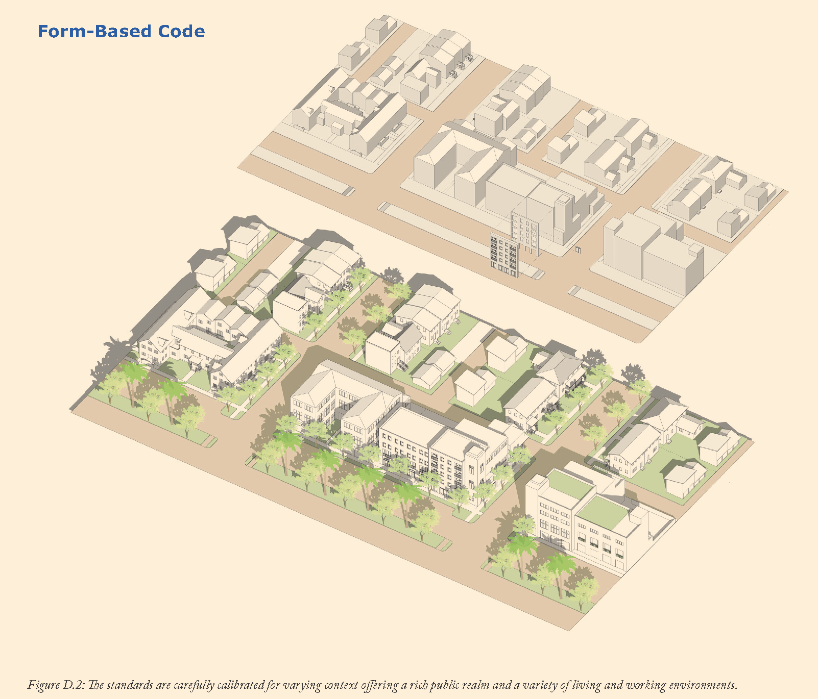
The Downtown Montebello Code is a form-based code (FBC). FBCs are an alternative to conventional zoning regulations. FBCs are purposeful place-based regulations with an increased focus on the design of the public realm: the public space defined by the exterior of buildings and the surrounding streets and open space.
FBCs are used to protect and preserve stable areas from incompatible development and to attract appropriate (re) development to transform areas at risk. This FBC reinforces the historical form patterns with the use of streets, frontages, buildings, and open spaces that are appropriate for Downtown Montebello context.
A key difference between conventional use-based and FBCs is that FBCs do not determine entitlements through FAR or floor units per acre. The conventional density controls have failed to produce diversity in living and working arrangements in a contextual manner. Overly restrictive use and density regulations are common barriers to small-scale development.
The focus of this code is on the few but critically important urban standards that shape the public realm. These include design of streets and open spaces, setback, building height, building frontage at street level, parking, and access.
The properties in Downtown Montebello are build-out. The vision for Downtown Montebello calls for incremental and contextual infill development.
The regulations in this code focus on creating a unifying public realm and is intended to be lean and less regulatory on the private side. The Downtown Montebello area is distinctively different than neighboring downtown or residential areas. The area will develop incrementally and more organically.
This code intentionally encourages improvisation and innovative infill development that creates a rhythmic patterns of existing and new buildings unified by a distinctive, vibrant, and walkable public realm.
4.1 Purpose and Application
4.1A Purpose
1.1A
Intent.
The Development Code implements the Downtown Montebello Specific Plan's Vision, Goals and Policies. This Development Code is intended to facilitate the continuing evolution of the Plan Area into a place where:
1.
A mixture of land uses including shops, workplaces, and residences are within walking distance of one another and produce an urban form that is inviting, comfortable, safe, and ecologically resilient;
2.
Streets and open spaces promote vibrant, safe, healthy, and prosperous place; and
3.
New infill and remodeled buildings work together with existing buildings to define the pedestrian-oriented space of the public streets within the Specific Plan area, and are harmonious with each other and the desired character of the Specific Plan area.
1.1.B
Relationship to the Montebello General Plan
The Downtown Montebello Specific Plan Code is consistent with the Montebello General Plan currently in effect, as required by Government Code 65000, et seq., California Statute. The Downtown Montebello Specific Plan Code implements the General Plan's community supported goal to 'direct new growth to downtown, corridor, and neighborhoods in need of reinvestment where viable infrastructure is already in place."
1.1.C
Relationship to the Municipal Code
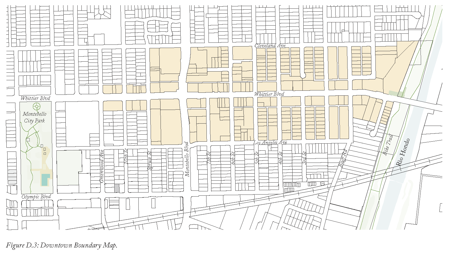
Title 17, Chapter 17.040.110 of the Montebello Municipal Code (MMC) shall be referred to as the "Downtown Code." The Downtown Code provides all requirements for development and land use activity within the boundaries identified in Figure D.3. Except as specifically referenced within the Downtown Code, the Montebello Municipal Code requirements in place prior to the adoption of the Downtown Code are hereby replaced by Chapter 17.040.110.
4.1B Use and Applicability
1.2A
Use of Downtown Code
The Downtown Code shall be administered by the Montebello City Council, hereafter referred to as the "Council;" the Planning Commission, hereafter referred to as the "Commission;" the City Planner; and the Montebello Planning Division, hereafter referred to as the "Planning Division."
1.
Responsibility for Administration: The Planning Division shall be the primary body responsible for administering the Downtown Code subject to the provisions of Title 17.
1.2.B
Applicability to Municipal Code
Property, including structures, land uses and physical improvements such as signs, landscaping, and lighting within the boundaries of the Downtown Code (Figure D.3) shall comply with all applicable requirements of the Downtown Code as follows:
1.
Zoning District(s) Requirements: All property subject to the Downtown Code shall comply with the relevant requirements of the applicable zoning district(s).
2.
Conflicting Requirements: Where a requirement exists for the same topic, in both the Downtown Code and other sections of the Montebello Municipal Code, the requirement of the Downtown Code shall prevail unless otherwise specified.
3.
Permit Approval Requirements: Each structure and land use shall be constructed, reconstructed, enlarged, altered, or replaced in compliance with the following requirements:
a.
Allowable Use: The land use must be allowed in the zoning district where the site is located (see Table D.3).
b.
Permit and Approval Requirements: Any and all permits or other approvals required by the Downtown Code shall be obtained before the issuance of any required grading, building, or other construction permit, and before the proposed structure is constructed and land use established or otherwise put in operation.
c.
Development Standards and Conditions of Approval: Each land use and structure shall comply with the applicable development standards of the Downtown Code for the zoning district in which the site is located.
4.
Improvements, Modifications, or Expansions of Sites or Structures
a.
Improvements to Conforming Structures or Sites: Applicants that involve an improvement to a conforming site, an existing conforming structure(s), or a modification/expansion of an existing conforming structure(s), sign(s) are subject to the applicable requirements of the Downtown Code.
b.
Improvements to Non-Conforming Structures or Sites: Applicants that involve an improvement to a non-conforming site, an existing non-conforming structure(s), or a modification/expansion of an existing non-conforming structure(s), or sign(s) shall comply with the applicable requirements of Section 1.2C.
c.
Civic Buildings: Applications that involve a civic building as defined by the Downtown Code shall comply with Section 1.2B.7.
5.
Modification or Subdivision of Existing Parcel(s): Applications involving the modification of an existing parcel or the subdivision of an existing parcel shall comply with the applicable requirements of the applicable zoning district(s) and Section 4.3 Public Realm (Subdivision, Streets, and Block Standards).
6.
Approved Entitlements: Entitlements approved prior to the adoption of the Downtown Code that have yet to be constructed are not subject to the Downtown Code. The entitlement(s) may not be extended beyond the four-year approval period and upon expiration, the owner must demonstrate substantial completion in constructing the approved structure(s) or the property shall then comply with the Downtown Code. Substantial completion means at least 90% completion of the approved structure(s) as determined by the Building Official.
7.
Civic Buildings: Applications involving the modification or construction of a building for civic purposes as defined in Section 10.0 "Glossary," shall comply with the following:
a.
Section 4.4 Development Standards and Section 4.5 Frontage Standards are not required of civic buildings.
b.
All other sections of the Downtown Code apply.
1.2.C
Non-conforming Lots, Uses, and Structures
1.
Intent: The regulations of this section are intended to:
a.
Recognize the interests of property owners in continuing to use their property for uses that were lawfully established.
b.
Promote maintenance, reuse, and rehabilitation of existing buildings.
c.
Place reasonable limits on nonconformities that have the potential to adversely affect adjacent properties.
2.
Non-conforming Lots: Lots which are non-conforming as to lot area or lot width may be adjusted or subdivided provided the resulting re-configuration brings the non-conforming lot into, or closer to conformity with the requirements of current applicable regulations.
3.
Non-conforming Use: Non-conforming uses are those that were legally established but that are not currently listed as permitted or conditionally permitted in the zoning district in which they are located or those that currently require a conditional use permit but at the time of their initiation did not require a conditional use permit. The following provisions shall apply to legal Non-conforming uses:
a.
No Non-conforming use shall be expanded or moved in whole or part to any portion of the lot or parcel upon which it is located or other structure other than that occupied by such use at the time it was established.
b.
No Non-conforming use shall be changed to a different Non-conforming use.
c.
If a Non-conforming use is discontinued or abandoned for a continuous period of 180 days or more, such use shall be deemed to have lost its Non-conforming status and shall not be reestablished.
4.
Non-conforming Structures:
a.
Additions: A Non-conforming building or other structure may be added to, provided that an addition of 50% or more of the floor area existing as of the adoption of this Downtown Code shall trigger compliance with all Downtown Code provisions for the portion of the building or structure comprising the addition.
b.
Repairs and Maintenance: General non-structural repairs and normal maintenance necessary to keep a nonconformity in sound condition are permitted. Structural repairs to a legal non-conforming structure may be authorized by the Building Official if it is determined that said repairs are necessary to protect the health and safety of the occupants, public at-large, or adjacent property and the cost does not exceed 50% of the replacement cost of the legal non-conforming structure. Structural improvements required to strengthen unreinforced masonry structures in compliance with seismic safety standards shall be permitted without replacement cost limitations.
c.
Replacement of Non-conforming Structures: Any non-conforming structure that is involuntarily damaged by fire or other catastrophic event may be restored or reconstructed to its original condition provided that the cost of such restoration/reconstruction does not exceed 50% of the replacement value of the structure and that the restoration shall commence within one year from the date the damage occurred.
4.2 Zones and Regulating Plan
4.2A Zoning Districts and Overlays
4.2A.1
Purpose and Establishment of Zoning Districts and Overlays
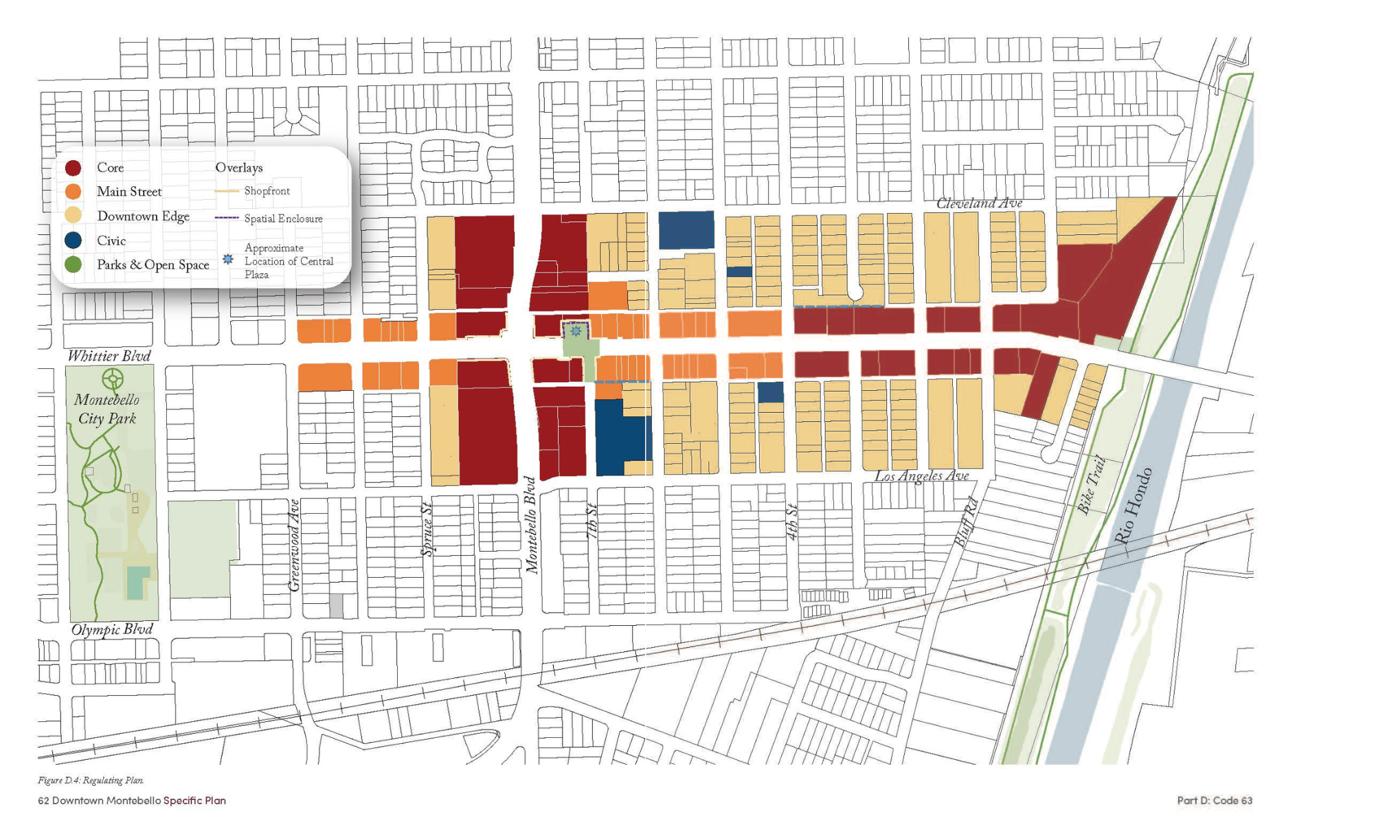
This section establishes the zoning districts and overlays to implement the Downtown Montebello Specific Plan for property and rights-of-way within the Downtown Code boundaries. Property and rights-of-way subject to the Downtown Code shall be divided into the following zones and overlays, which shall be applied to all property as shown on Figure D.4.
4.2A.2
Zoning Districts and Overlays
The Downtown Code is consistent with the Montebello General Plan currently in effect, as required by Government Code 65000, et seq., California Statute. The Downtown Code implements the General Plan's community supported goal to direct majority of the new infill growth to downtown in a contextual manner.
4.2B Regulating Plan
4.2B.1
Purpose and Establishment of Regulating Plan
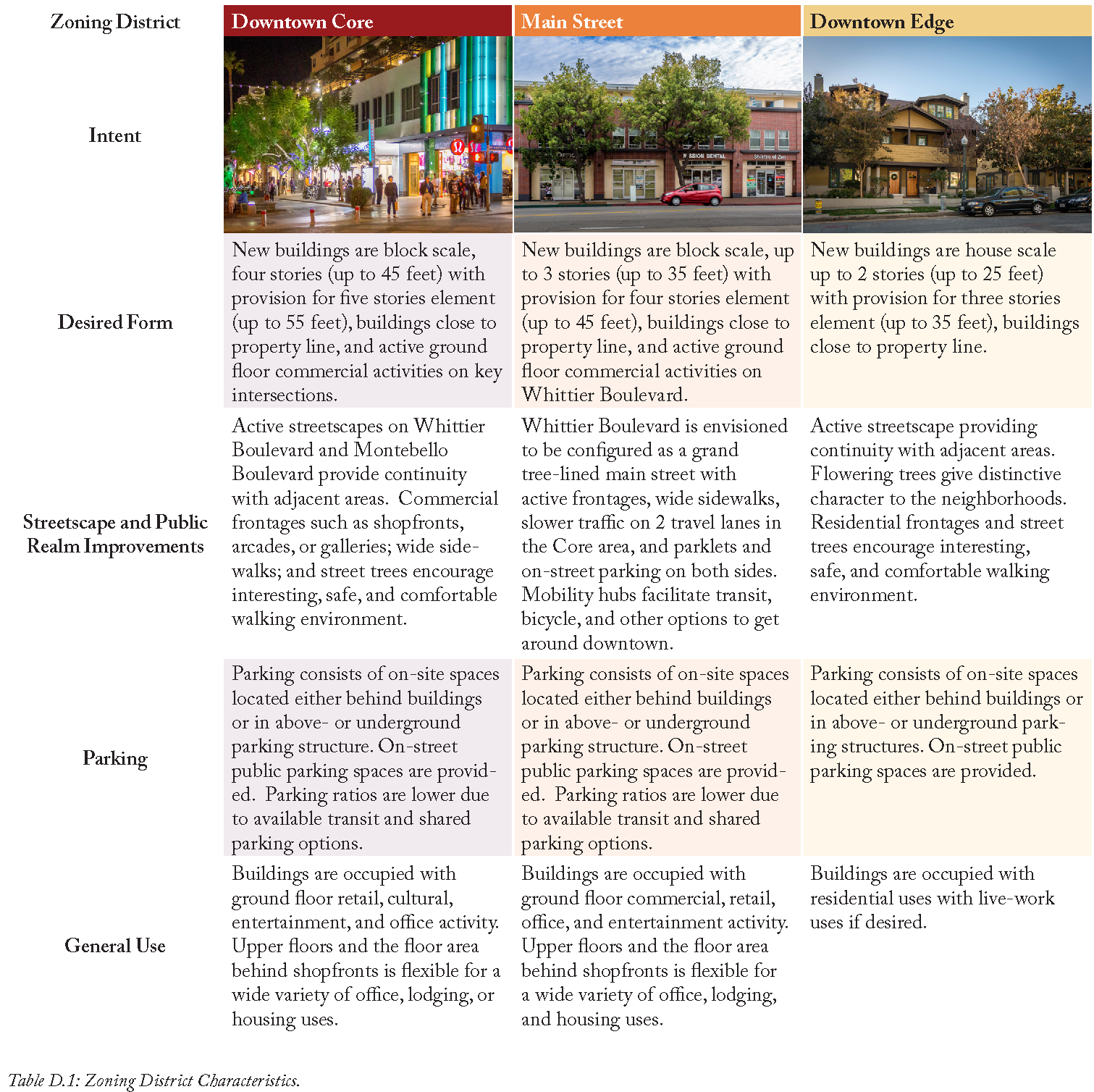
This section establishes the regulating plan, Figure D.4, as the map that identifies and implements the various intentions and principles of the Downtown Plan. Table D.1 defines the zoning districts, overlays and standards for site development, design and land use through the following:
a
Zoning Districts: Each zoning district is allocated standards in the following areas:
•
Building Placement
•
Allowed Development Standards
•
Allowed Frontage Types
•
Building Height and Size
•
Allowed Encroachments into Required Yards
•
Parking Placement and Site Access
•
Required Parking
•
Allowed Land Uses
b
Shopfront Frontage Overlay: This overlay requires buildings to have shopfront frontage and a minimum floor-to-ceiling height. This requirement is to accommodate ground floor live-work, commercial, retail or other such non-residential activity on streets where the vision expects active, pedestrian-oriented streetscapes.
c
Spatial Enclosure Frontage: Spatial enclosure is the three dimensional alignment of facades with one another in a coherent manner so as to define the public realm and create a sense of place. The spatial enclosure also projects the unique geometry of the streets and traffic flow vertically around the uniquely shaped parcels thereby promoting safe driving. This overlay requires the frontages of the parcels to be lined with building facades to shape and enclose the streets or open spaces.
d
Regulating Plan Diagram: Each zoning district and overlay established by the Downtown Code is identified on Figure D.4 to show the boundaries of each zoning districts, overlay, and the parcels within each boundary. Figure D.4 is established as the zoning atlas for all property within the Downtown Code boundaries.
4.3 Public Realm
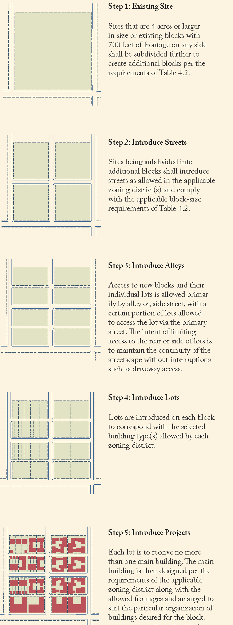
4.3A Blocks
4.3A.1
Purpose
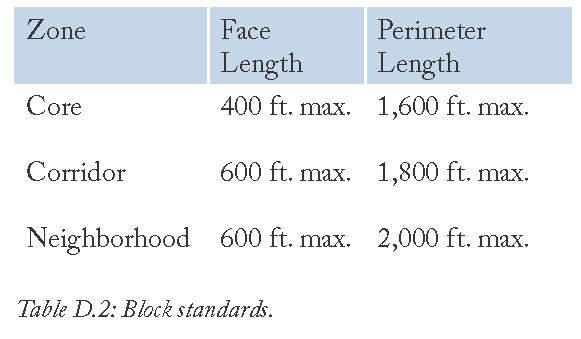
The design of blocks influence the type of street network, building types, and the quality of urban space. Smaller blocks produce more intersections, therefore more human scale buildings, greater public realm and superior street network system. All blocks shall be designed per the applicable requirements identified in Table D.2 to ensure that new and modified blocks result in walkable, interconnected streetscapes aligned by appropriately scaled buildings.
4.3A.2
Applicability
The standards shall apply to all new or modified blocks in the Downtown area.
4.3A.3
Streetscape Standards
a
New or modified blocks shall front a street (public or private).
b
New or modified blocks shall be subdivided to generate individual lots for buildings or open space as required by the applicable zoning district(s) and overlay(s) and in compliance with Section 4.4 Development Standards.
c
New or modified blocks may be designed in a variety of shapes. Individual block faces and the total block perimeter shall follow the standards established in the Table D.2 below.
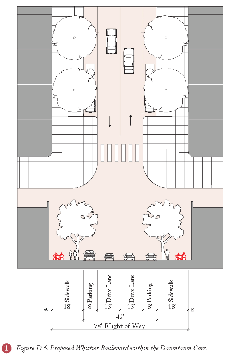
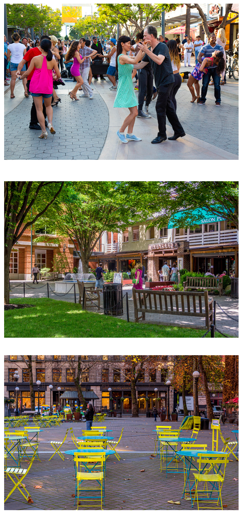
4.3B Streets
4.3B.1
Intent
The key to transforming the Downtown into walkable area is the introduction of an interconnected street network with streets that are sized appropriately for intended volume and safe traffic speeds. The principal characteristics and strategies of this kind of network are:
a.
Interconnected streets that serve all modes of travel, including walking, biking, taking transit, or driving.
b.
A diversity of context based street types, each designed according to the adjacent building intensities and uses and each with its own unique character.
c.
Streets that accommodate two-way traffic, facilitating navigation and safe traffic speeds, while eliminating traffic-related fatalities.
d.
On-street parking that provides convenient parking in front of businesses and residences, reduces the amount of required off-street parking, provides a barrier between vehicles in the travel lane and pedestrians on sidewalks, and provide a presence on the street that helps calm vehicular speeds.
e.
Appropriate lane widths, tight curb radii, and narrow street crossings that calm traffic and provide a more comfortable and safe environment for pedestrians, cyclists, and automobiles.
f.
Ample sidewalks, crosswalks, street trees, and generous streetscapes that provide shady, comfortable, and inviting places for pedestrians to walk, while defining the Montebello Downtown's unique and memorable sense of place.
g.
Streets that result in a reduced quantity and improved quality of stormwater runoff, and a diminished heat island effect.
h.
Energy-efficient, pedestrian-oriented lighting that generates an inviting and safe environment for pedestrians, cyclists, and commerce.
4.3B.2
Applicability
a.
The standards in this section apply to all new streets and to the substantial improvement of an entire block length of an existing street, subject to the review and approval of Public Works Director.
b.
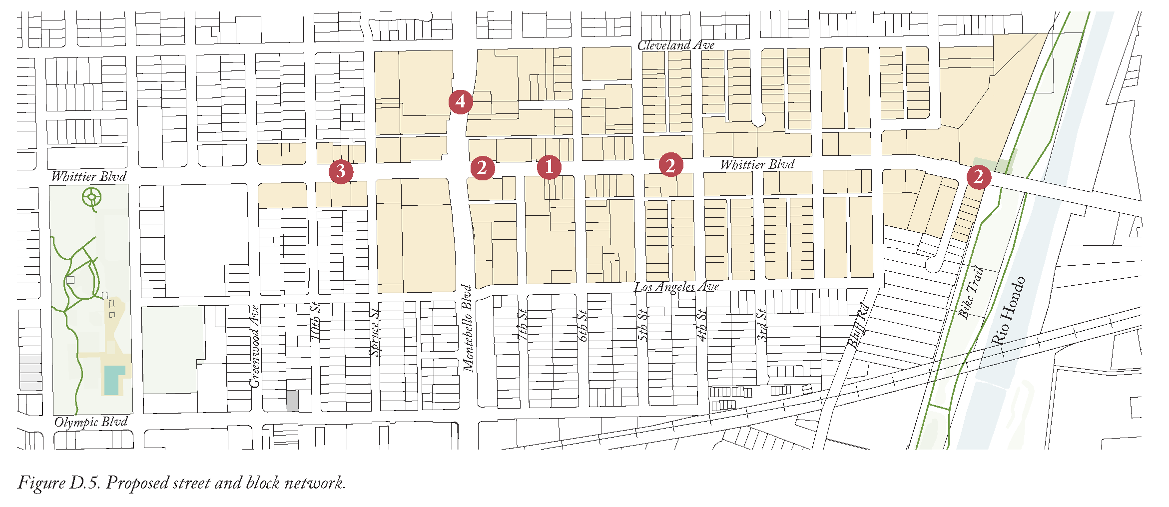
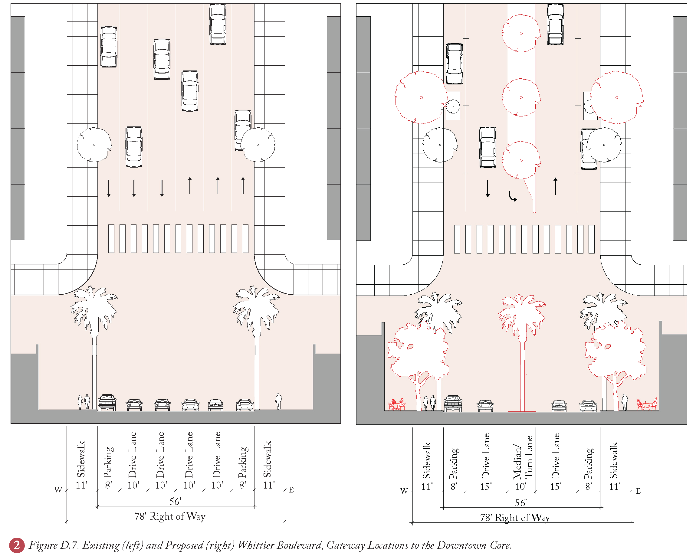
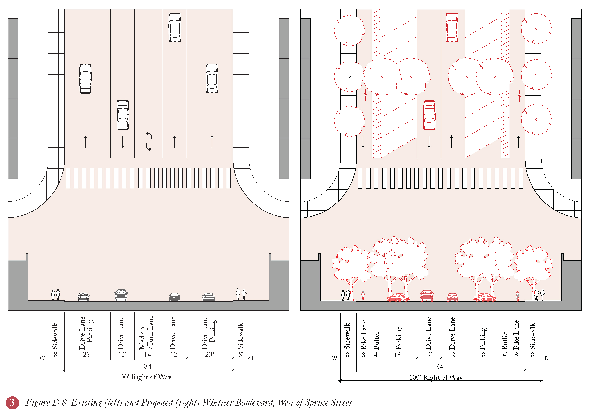
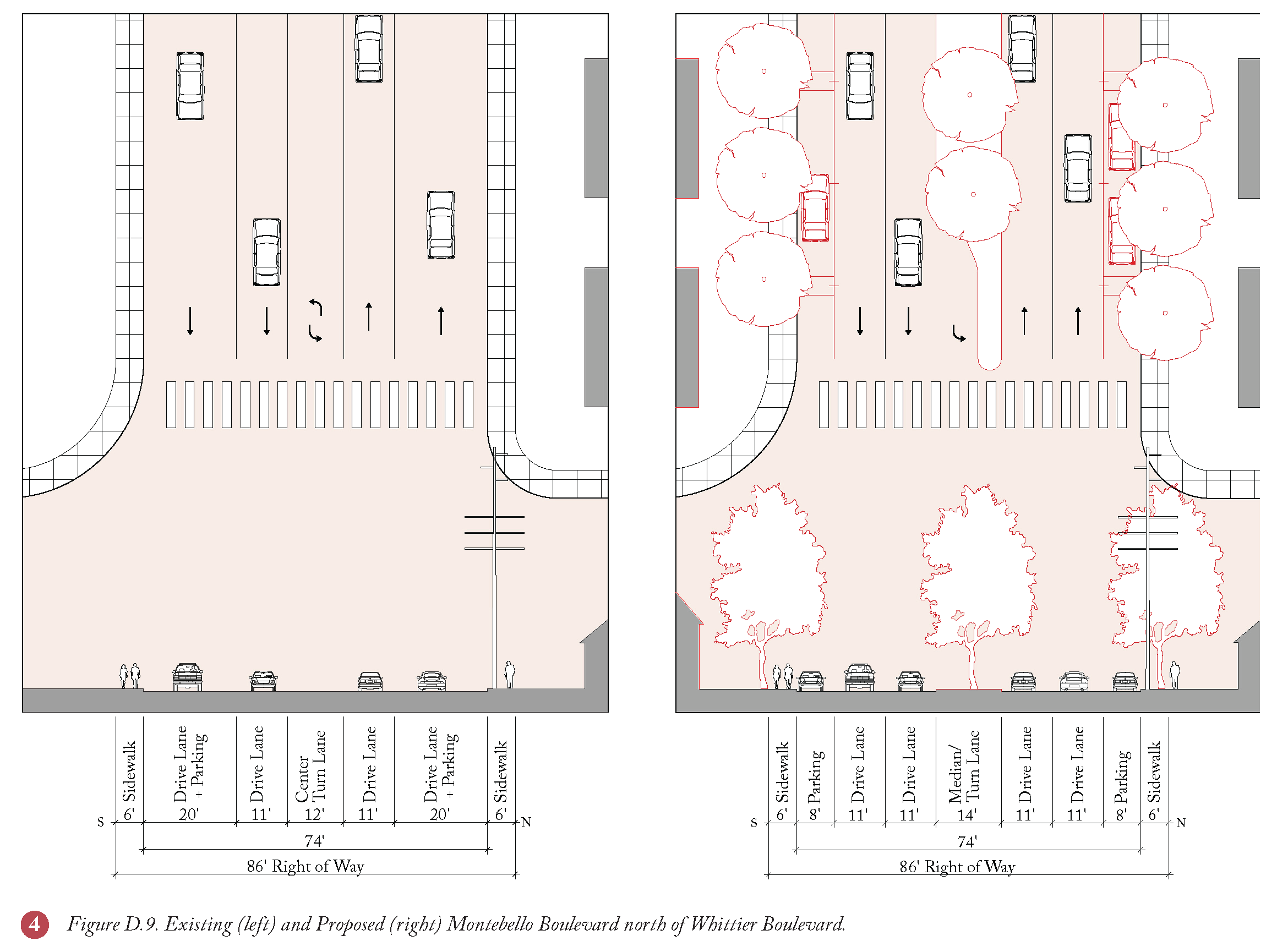
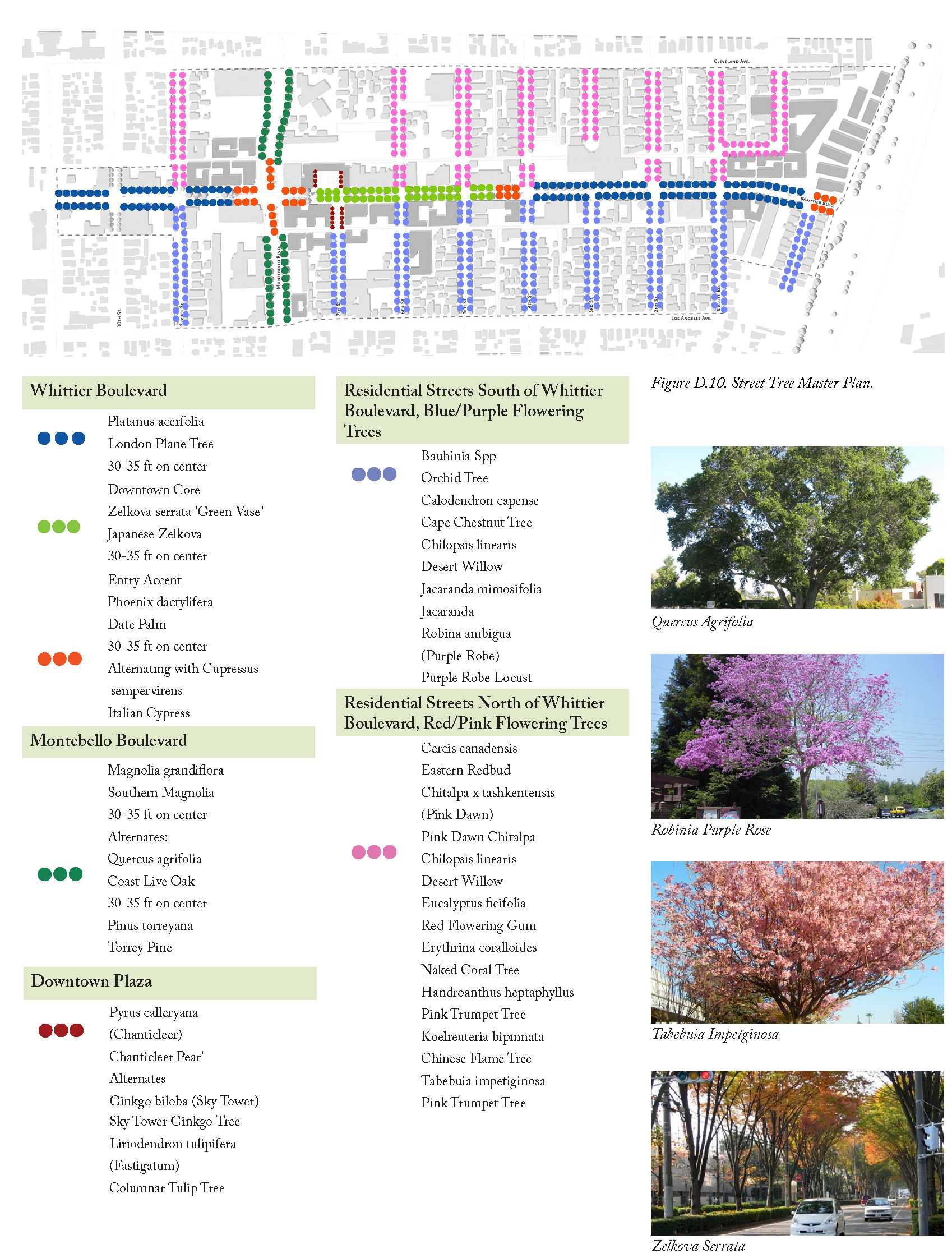
Figure D.5 shows the proposed street and block network applied to the entire Plan Area. Additionally, Figure D.10 shows specific landscape characteristics for each street, differentiating it from other streets within the Plan Area, and contributing to the richness of the Downtown area's sense of place.
4.3C Street Trees
4.3C.1
Intent
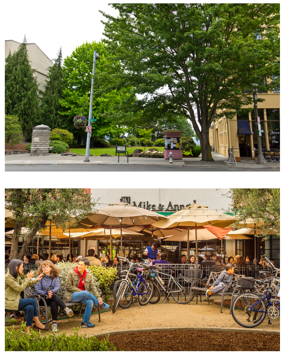
The intent of Street Trees is to provide a comfortable, rich pedestrian experience with shade, planted edges in the public right of way, and increase environmental performance with low impact development strategies that absorb and clean urban runoff.
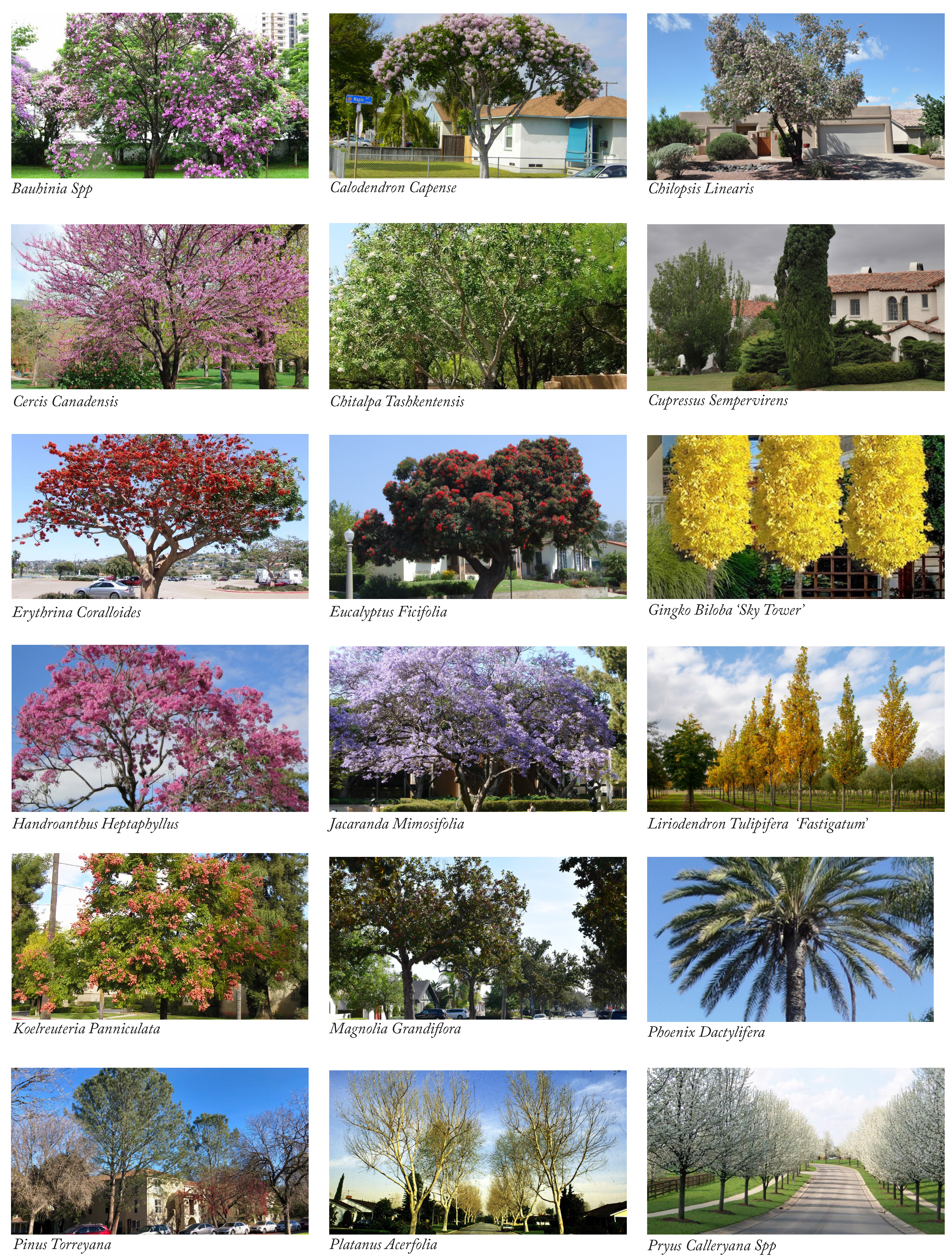
The Street Tree Master Plan (see Figure D.10) locates specific tree species amongst the public realm's street network, open spaces, and greenways. Tree species are chosen for each type of thoroughfare and open spaces to support its unique aesthetic character, spatial quality, and environmental value. Tree selection considerations included the tree's shape, color, seasonal change, scent, size at maturity, drought tolerance, and resilience.
The numerous qualitative benefits from selecting a diverse street tree palette include shade for pedestrians walking along the sidewalk, a visual rhythm to reduce driving speeds along vehicular streets, and overall balance of the built environment. A street tree's environmental benefits include cooling the immediate area, local air quality improvement through carbon sequestration, and stormwater management which contribute toward pedestrian friendly urban character of Downtown Montebello.
The street tree species shown in Figure D.10 (Street Tree Master Plan) are conceptual and may be adjusted subject to Public Works Director and/or Planning and Community Development Director approval.

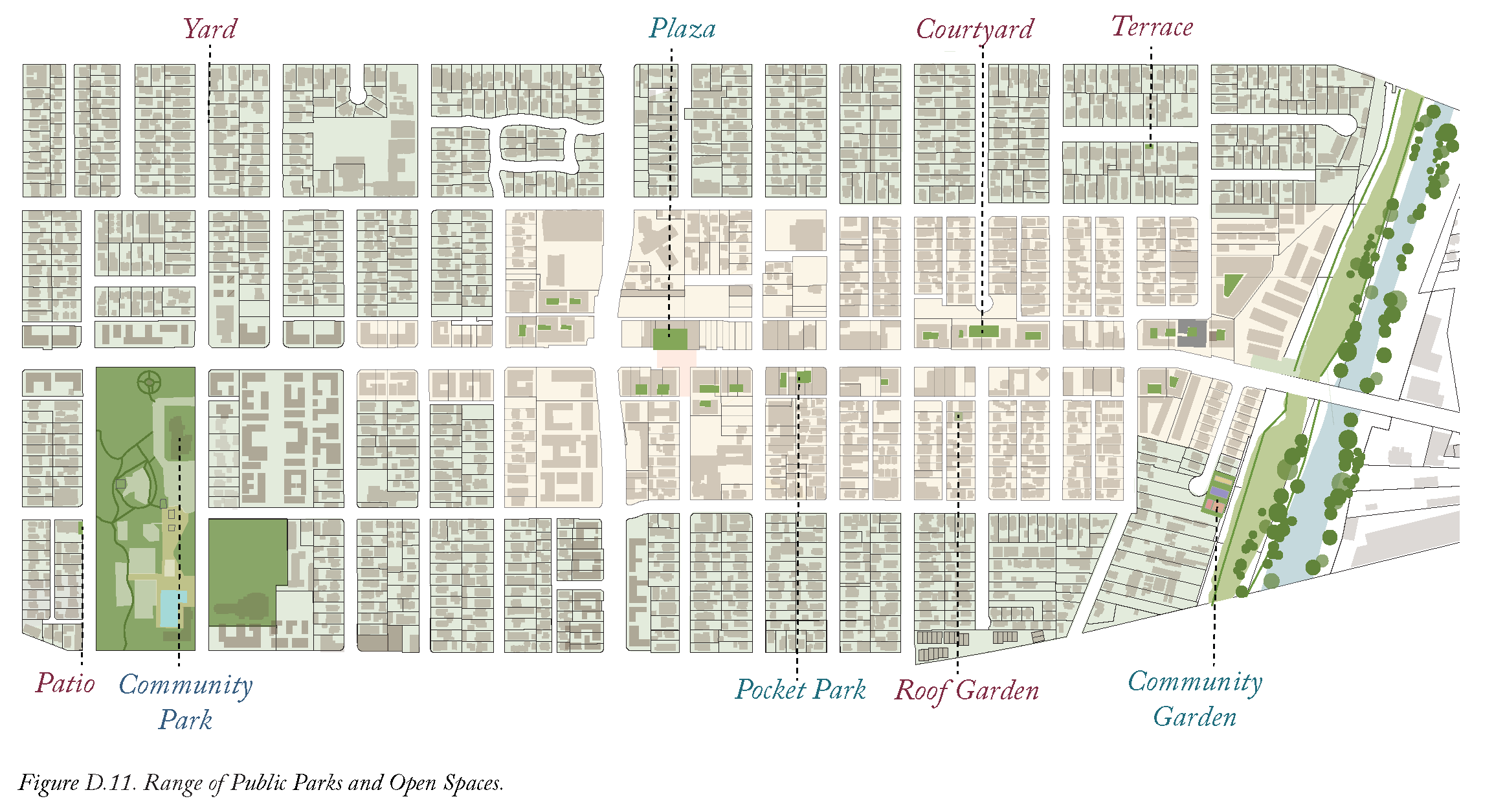
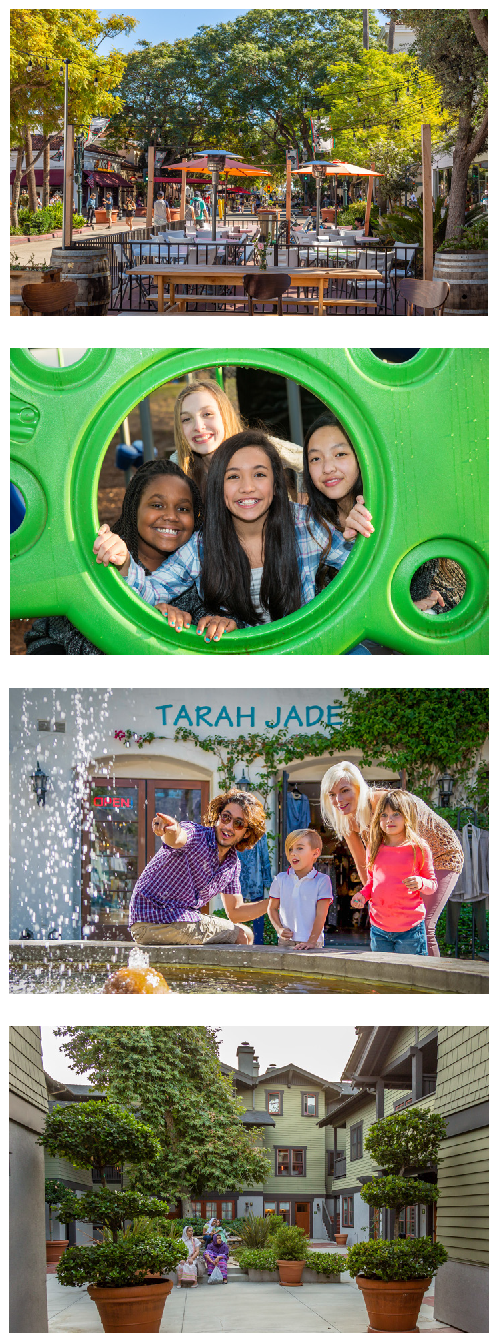
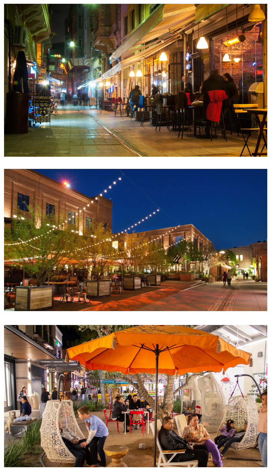
4.3D Parks and Open Space
4.3D.1
Intent
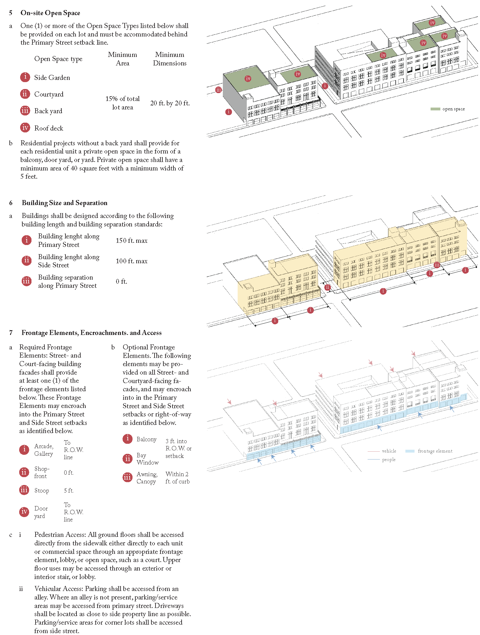
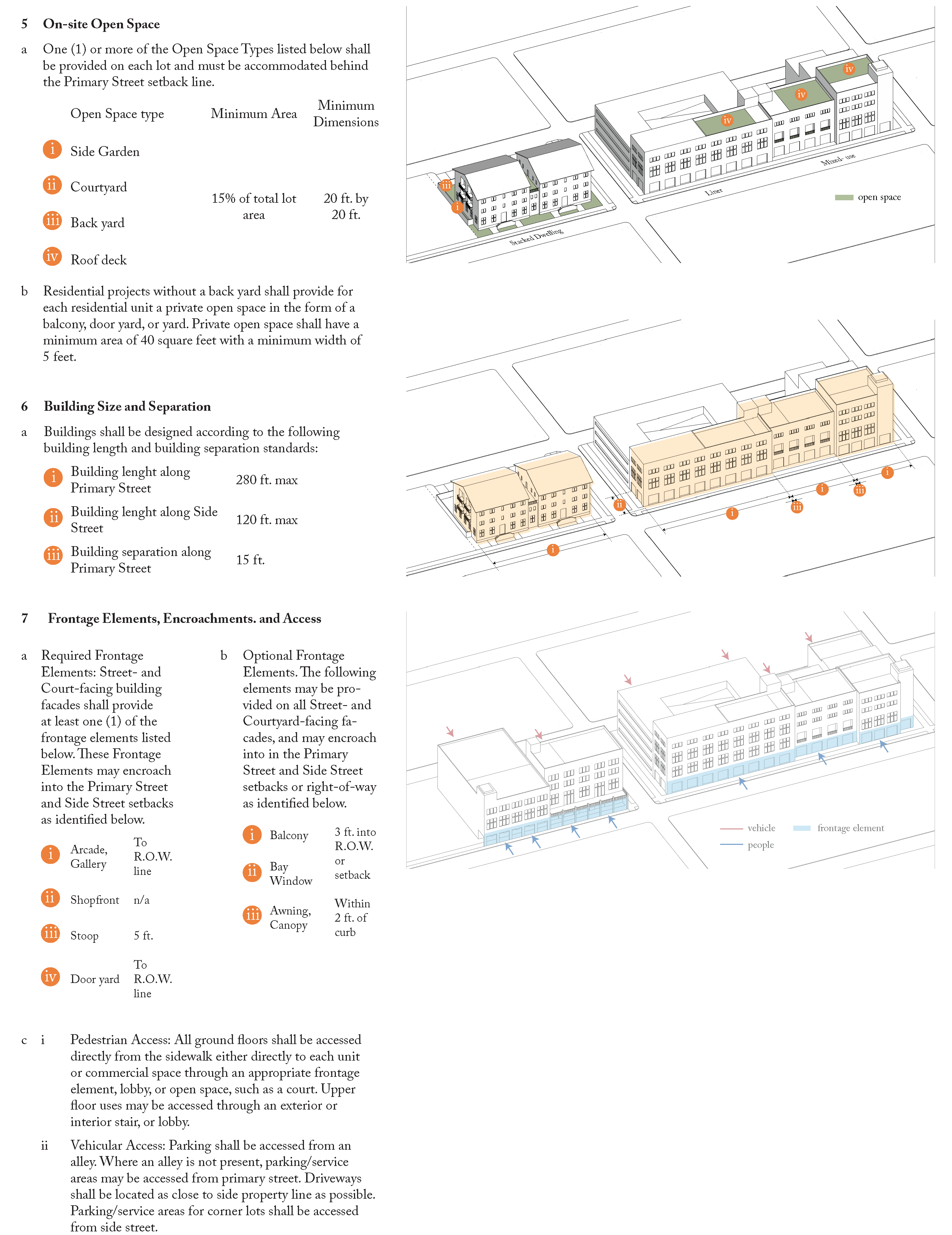
This section establishes a range of open spaces specified based on location and characteristics such as size, landscaping, access, and frontage conditions needed to implement the intended form and character for Downtown. The Downtown Specific Plan vision seeks to establish a seamless weave of public and private open spaces at the regional, neighborhood, block, lot, and building level. The Development Standards include private open space requirements for different building types.
The intent of this section is to:
a.
To improve quality of life, instill civic pride, and sense of community.
b.
Provide places for diverse people to meet and interact thereby increasing social capital of the neighborhood.
c.
Increase property values and helps attract and retain knowledge workers and businesses.
d.
Provide venues for many arts and cultural programs which also promotes tourism.
e.
Through informal play and shared experiences with peers, open spaces inspire children to explore, discover, learn and become better stewards of the about natural environment.
f.
Promote walking, biking, and other physical activities essential for fitness and well being and to reduce diabetes, and heart and mental illness.
g.
Reduces the urban heat island effect. Trees in parks and open spaces sequester carbon and other pollutants from the area.
4.3D.2
Applicability
The standards shall apply to all new or modified blocks in the Downtown area. Additional Public Open Spaces can be integrated into this section as they are approved by the City.

I
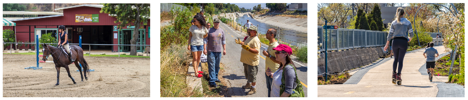
Rio Hondo Channel Greenway
a
Description
The Greenway is a linear open space intended to provide extensive opportunities for recreation. The Greenway corridor would connect many neighborhoods, existing parks, schools, and other regional parks and open spaces along the Rio Hondo Channel. It would also connect the wildlife habitat and reducing the heat island effect.
b
Standards
i
Size: The greenway would be variable width and span the entire city. The greenway is part of a regional trail network.
ii
Design:
a)
The landscape along the greenway shall consist of unobstructed lawns, planting beds, naturalistically arranged trees. Hardscape is minimal in the form of access pathway and peripheral connections.
b)
Pedestrian amenities such as benches, picnic tables, drinking fountains, exercise equipment, bike racks and playground equipment may be located at appropriate intervals along the greenway.

II
Central Plaza
a
Description
Plaza is an urban public space that serves as a public gathering place or a place for celebratory events.
b
Standards
i
Size: 0.25 acre to 0.5 acre
ii
Design:
a)
Plazas are highly visible located at the intersection of important streets and enclosed by active building frontages.
b)
Plazas are hardscape with little or no vegetation, usually requiring minimal maintenance.
c)
Amenities may include pergolas, flexible gathering and event spaces, benches, chairs, tables (movable recommended), bike racks, and public art.
d)
Infrastructure for special events, including water, power, and data, should be designed into the layout of select plazas.
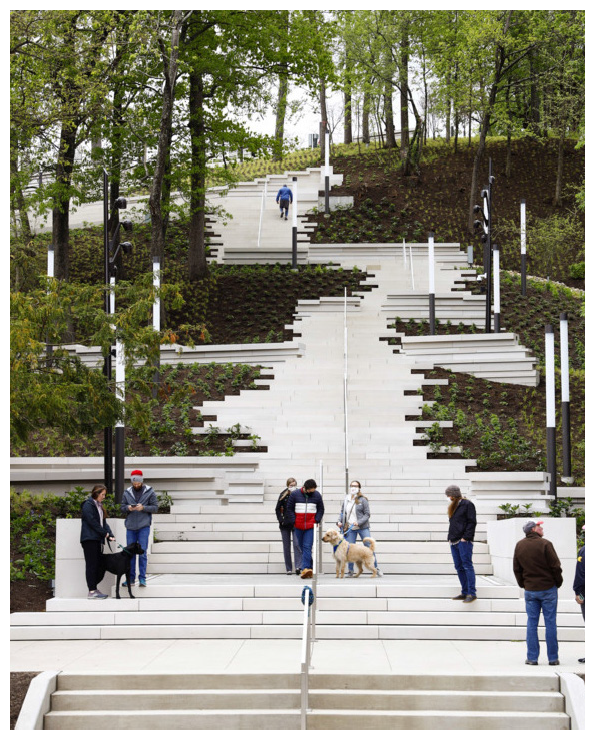
IV
Rio Hondo Connector Park
a
Description
This park connects the Downtown area to the Rio Hondo Channel. The connecter park space reinforces the daily commuter entry arrival into Montebello from the east.
b
Standards
i
Size: Variable linear space.
ii
Location: Located adjacent to the Whittier Blvd Bridge crossing of the Rio Hondo this connecting space brings accessibility of the downtown to the river amenity.
iii
Design:
a)
Gentle curving ramps and stairs meander thru the space that is envisioned to have community works of art accenting the river walk connector experience.
b)
Bridge abutments are cladded with bas relief art works and sculptures and other environmental art elements are dotted along the walk.
c)
California Sycamore trees meander through the lush native riparian plantings of the connector walk and ramps.
d)
The space is secured at night with decorative functional art fences and gates and well-lit spaces.
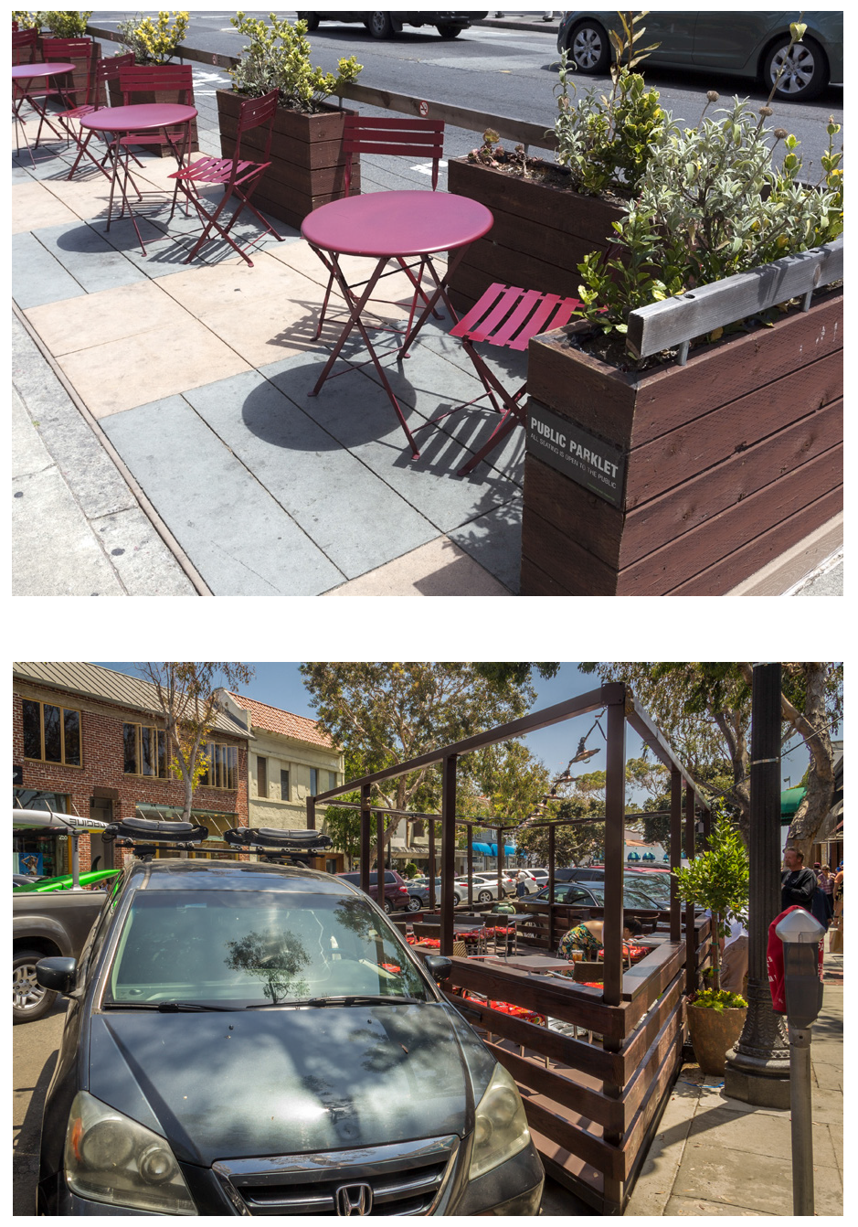
V
Parklet
a
Description
A parklet is a sidewalk extension into parking spaces that provides more space and amenities for people using the street.
b
Standards
i
Size: Variable linear space that includes one or more on-street parking spaces.
ii
Location: Parklets must be located at least one parking space away from an intersection or street corner.
iii
Design:
a)
Parklets are permitted on streets with speed limits of 25 mph or less.
b)
Parklets must include a platform/deck that is flush with the sidewalk, unless the parklet is designed to be terraced. Parklets must end at the sidewalk and parklet furniture, heaters, and landscaping may not spill onto sidewalk.
c)
Stable and sturdy traffic barriers must be installed on all three sides open to the roadway traffic. The barrier must have a minimum height of 36 inches and maximum height of 42 inches.
d)
To allow for water flow, parklets must provide a drainage channel that is a minimum of 3 inches tall and 2 feet wide, along the entire length of the parklet, adjacent to the curb.
e)
Parklets design and construction will be subject to Public Works approval. The design must be flexible to allow for any roadway or utility maintenance. Public Works has the right to close a parklet from use to perform maintenance work on adjacent infrastructure.
IV
Pocket Park
a
Description
Pocket parks are urban open spaces on a small-scale and provide a safe and inviting environment for surrounding community members. They also meet a variety of needs and functions, including: small event space, play areas for children, spaces for relaxing or meeting friends, taking lunch breaks, etc.
b
Standards
i
Size: Up to 0.25 acre
ii
Design:
a)
The parks shall be accessible by both foot and bike.
b)
Pocket parks shall strive to accommodate as many different users as possible, prioritizing the needs of surrounding neighborhoods. Pocket parks may include seating, play or fitness equipment, open lawn space, dog runs, community gardens, ecological/educational displays, and community bulletin boards.
c)
Pocket parks may be designed to serve as stormwater retention and infiltration areas.
VI
Paseos
a
Description
Paseos are pedestrian-only pathways that make the block porous, and provide opportunities to create unique public spaces.
b
Standards
i
Size: Variable linear space
ii
Design:
a)
Paseos create short cuts through long blocks, and may connect interior courtyards to street frontages.
b)
Use native plants to provide new bird and insect habitats, strengthening Montebello's urban ecosystems. Edible paseo gardens can also be planted, incorporating herbs and vegetables. The simplest solutions are potted plant gardens and window boxes.
c)
Well-lit paseos discourage crime, encourage pedestrians, and can introduce artful elements. Adding softer lights, creating spaces with lighting, and playing with lighting temperature can bring new life and atmosphere to an alley.
d)
Amenities may include pergolas, flexible gathering and event spaces, benches, chairs, tables (movable recommended), bike racks, and public art.
e)
Paseos need to ensure emergency and maintenance vehicle access as appropriate.
VII
Private Open Spaces
a
Lot Level
Each building type shall prescribe private open space. For example the open space for single dwelling is provided in yards, courtyard buildings includes courts, and flex buildings and tower may provide terraces.
b
Within the building
In urban areas where private yard is not an option, balconies, patios, and roof garden allow residents access to open space, area for small-scale cultivation, recreation, and entertaining.
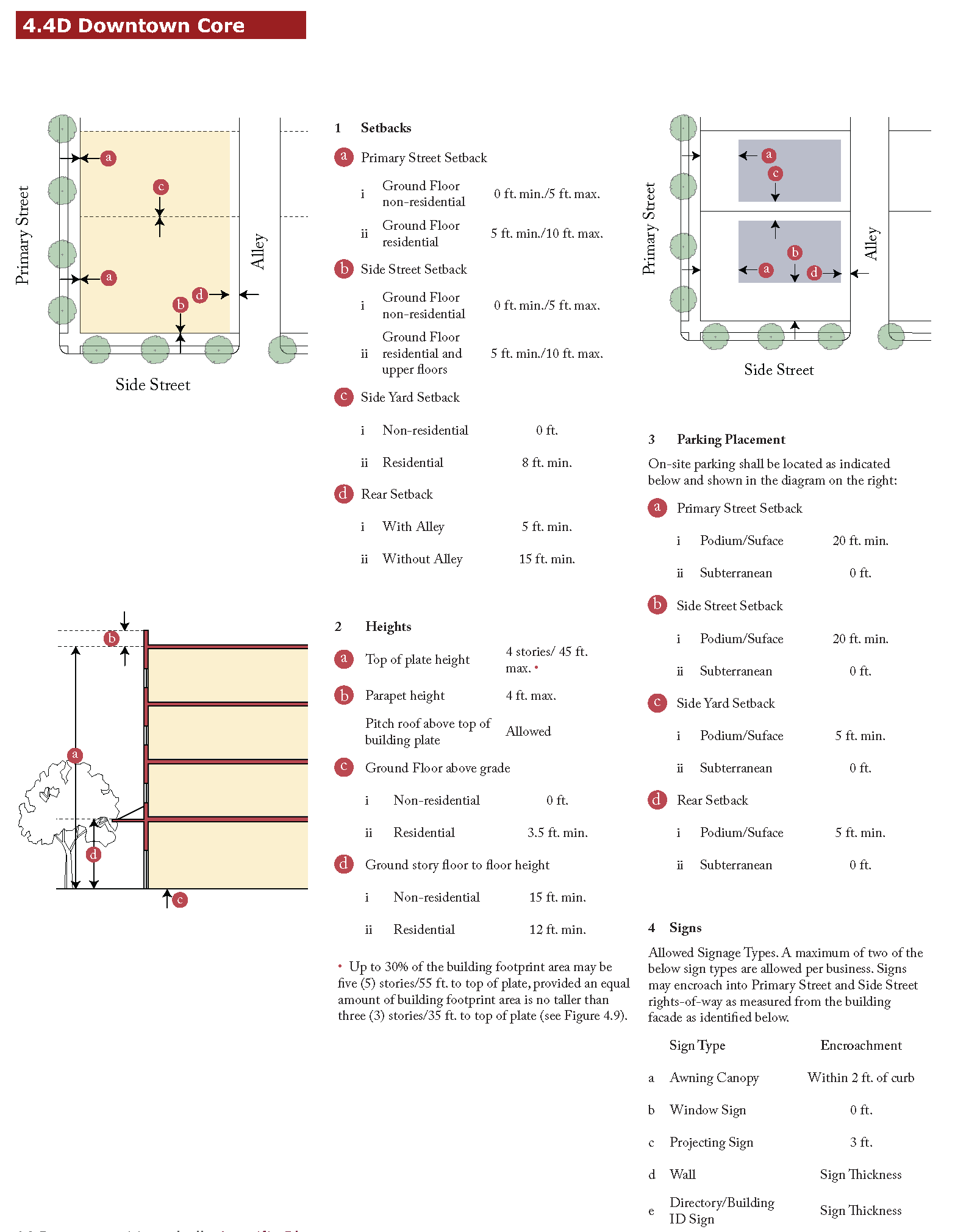
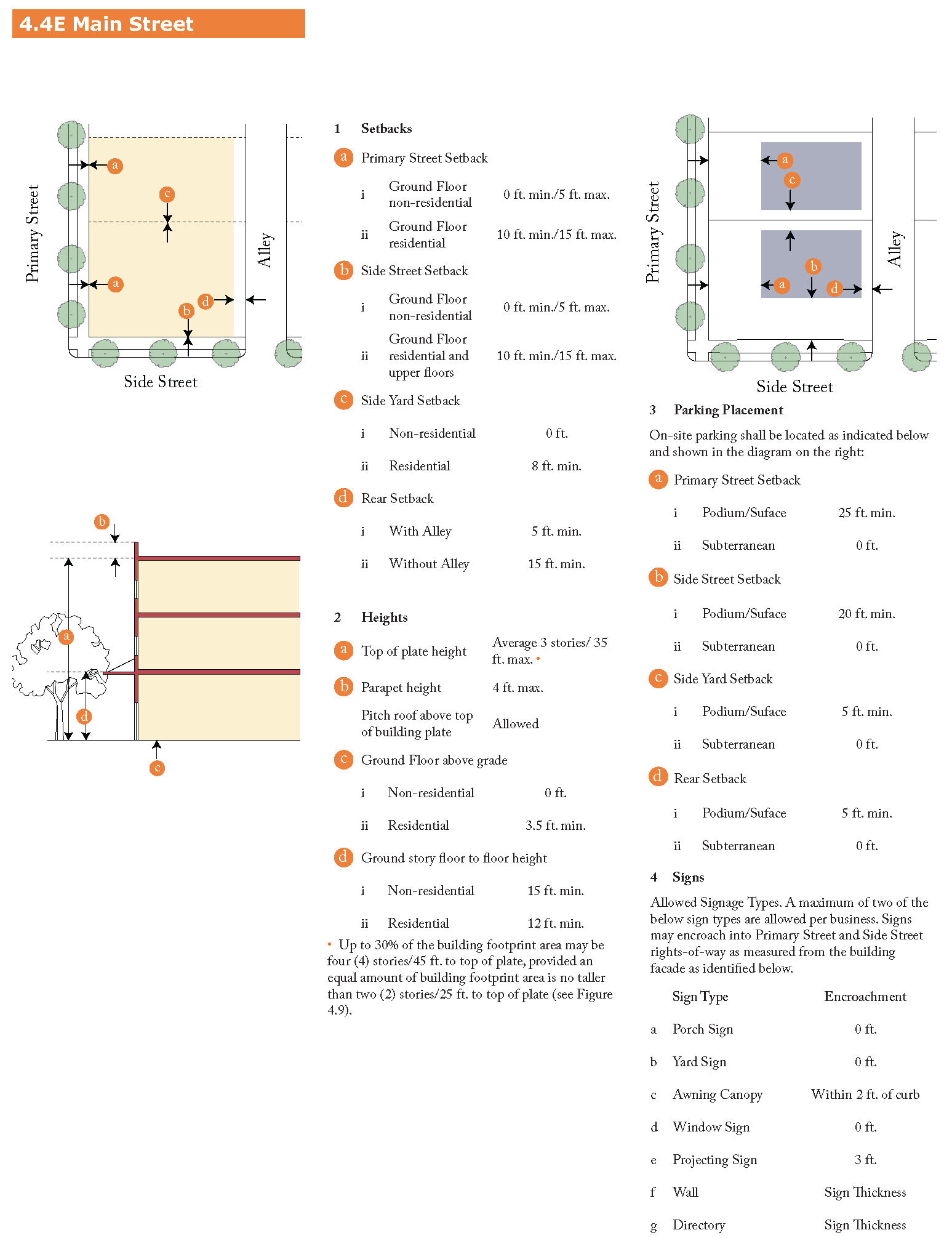
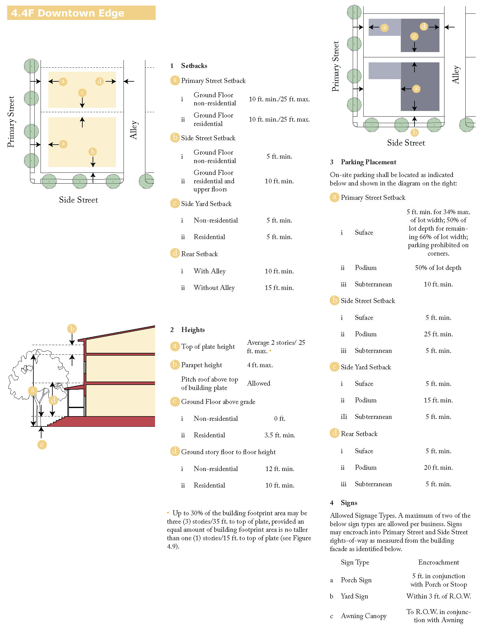
4.4 Development Standards
4.4A Purpose and Intent
This section establishes standards to ensure that development within the Downtown area promotes a safe, comfortable, and interesting walkable environment along the street by:
•
Placing the buildings in the front and locating the parking behind the building;
•
Providing access to adequate public and private parks and open space; and
•
Providing contextual building scale and mass, and pedestrian access and visibility that establish a human scale to the street.
4.4B Applicability
All proposed buildings and related improvements shall be designed in compliance with the development standards of this Section for the applicable zone, except for public and institutional buildings, which because of their unique disposition and application are not required to comply with these requirements.
4.4C Average Building Height
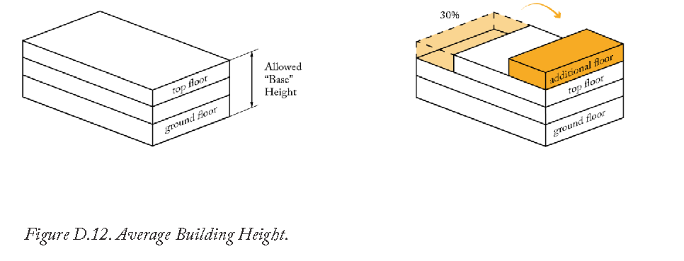
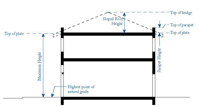
Building within the Downtown Core, Main Street, and Downtown Edge zones may exceed the maximum allowed base building height by one story for up to 30% of the building footprint area provided an equal amount of building footprint area is one story shorter than the maximum allowed base building height (see Figure D.12).
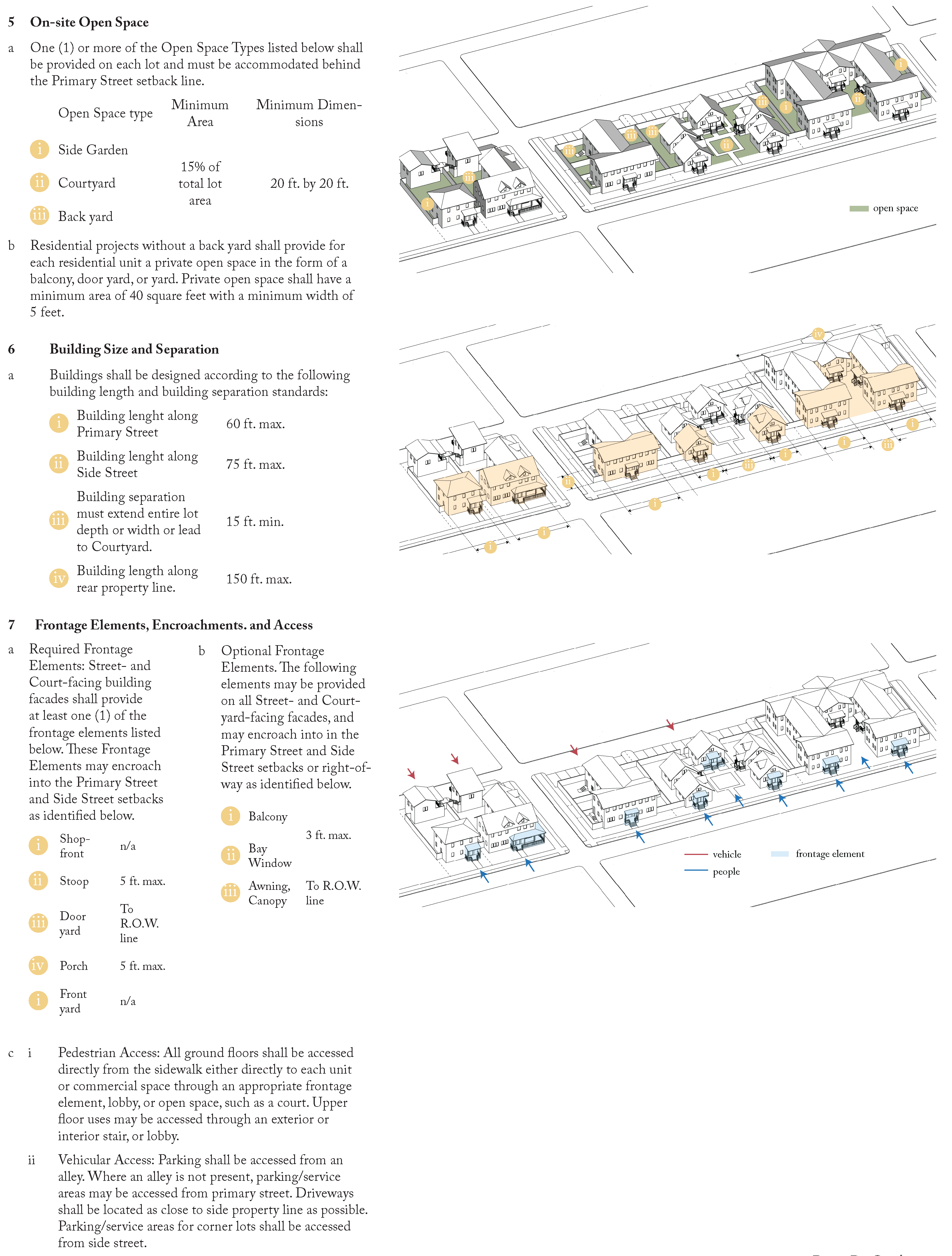
4.5 Frontage Standards
4.5A
Purpose and Intent
This Section establishes standards to ensure proposed development promotes a walkable environment along the street through the provision of street-facing windows, entries, and appropriately designed frontages; and commercial ground floors that support pedestrian activity through maximum ground floor transparency. Frontages consist of the street facade of the building(s), including any projecting elements, and any landscape, hardscape, walls, and fences between the building facade and the back of sidewalk. They provide a transition between the public environment of the street and the semi-private and private environments of the building interior. They also signal the location of the building entrance and provide a semi-public space within which neighbors and visitors can interact.
4.5B
Applicability
The requirements of this Section apply to all new buildings within the Downtown area.
4.5C
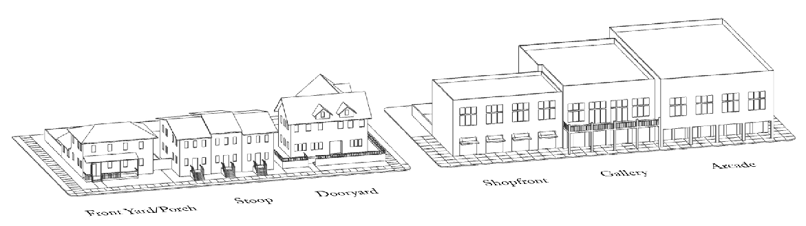
Frontage Types
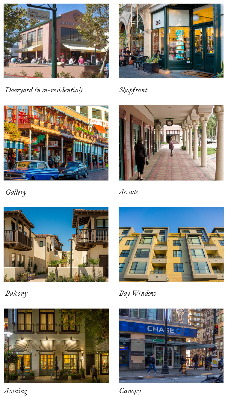
This Section identifies the frontage types allowed within the Downtown area, and for each type provides a description and design standards to ensure that proposed development is consistent with this Specific Plan's goals for building form, character, and quality. Frontage types are divided into two categories, Required (Porch, Stoop, Dooryard, Shopfront, Gallery, and Arcade) and Optional (Balcony, Bay Window, Awning, Canopy). The provisions of this Section work in combination with the underlying Zone as identified on the Regulating Plan. Refer to Sections 4.4D, 4.4E. and 4.4F for required and optional frontage types within each zone and allowed encroachments into the setback or right-of-way.
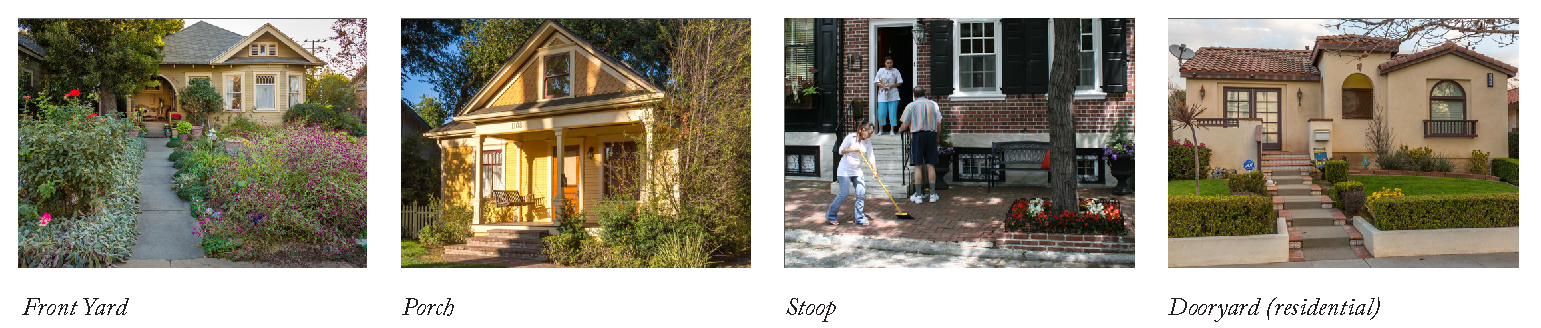
4.5Di
Front Yard
a)
Description: The area between the building facade and the property line. Front Yards may be visually continuous with adjacent yards with a common landscape, or enclosed by a low fence, wall, or hedge. On sloping sites, front yards may be raised above the level of the adjacent sidewalk and supported by a low retaining wall at the property line with steps providing access between the sidewalk and the yard. Porches, stoops, balconies, and bay windows may encroach into Front Yards.
b)
Design Standards
i)
Front yards and continuous planters between the curb and sidewalk along the primary and side streets shall be landscaped.
ii)
Paved areas shall be limited to walks and driveways, where present.
iii)
Fences defining the front yard shall not exceed four (4) feet as measured from the adjacent sidewalk.
4.5Dii
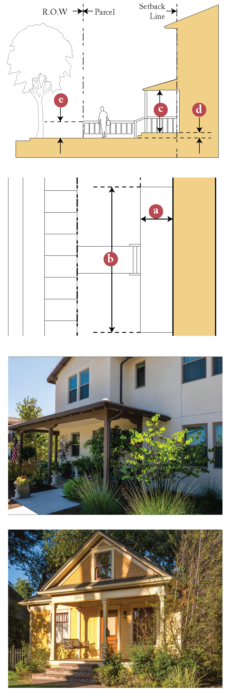
Porch
a)
Description: A roofed, unenclosed room attached to the exterior of a building that provides a physical transition between the sidewalk and the building. Porches may be provided on buildings that are set back from the Primary and/or Side Street property lines and may encroach into the front yard and side street yard.
b)
Design Standards
i)
Porches may be enclosed with insect screens if recessed from the exterior wall plane and if visibility is maintained from the sidewalk.
ii)
Porches shall be designed according to the following dimensional requirements:
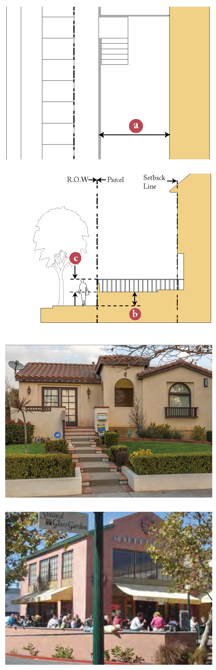
4.5Diii
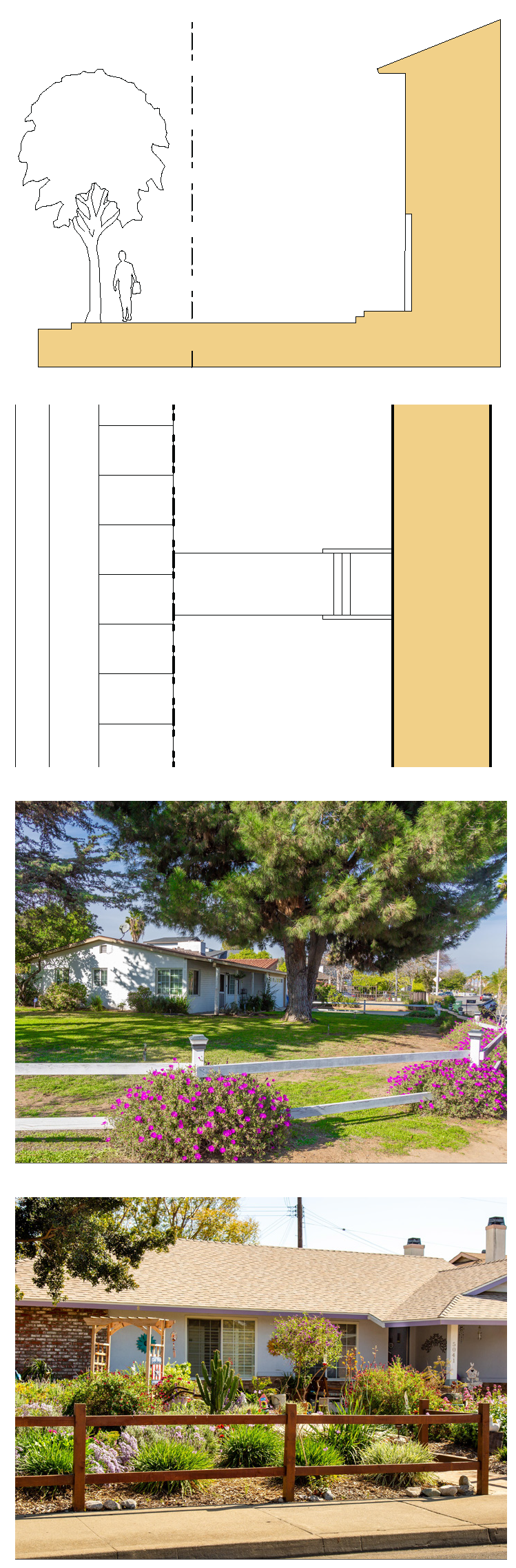
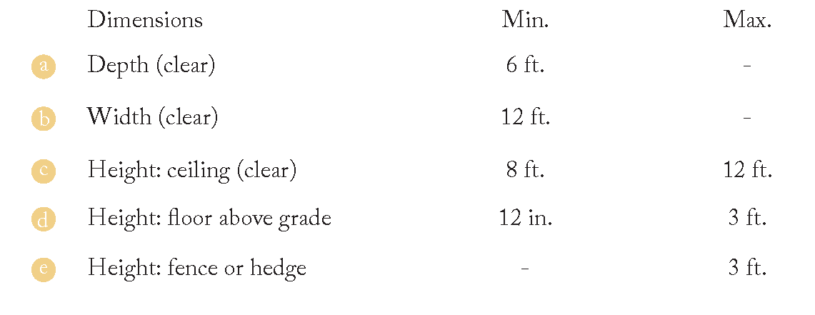
Dooryard
a)
Description: An elevated or at-grade garden or terrace that is located in the front yard setback and that is enclosed by a low wall located at or near the property line. For elevated Dooryards, access from the sidewalk to the Dooryard is via a stair or ramp. The Dooryard can accommodate a variety of activities, ranging from dining patios for commercial uses to patios for residential uses. In addition, the interior building spaces are separated from the adjacent sidewalk by the depth of the Dooryard and in the case of raised Dooryards, by the terrace height.
b)
Design Standards
i)
Walls and/or fences shall be consistent with the architectural style of the building in their design, materials, and finishes.
ii)
Dooryards shall be designed according to the following dimensional requirements:

4.5Div
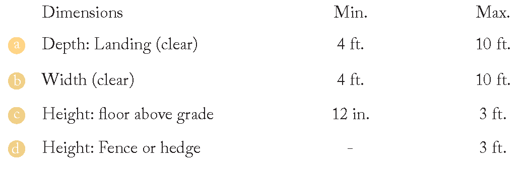
Stoop
a)
Description: A stair and landing leading directly from the sidewalk to a building entrance. The ground floor of the building is typically raised to provide increased privacy for the rooms facing the public street. Accordingly, stoops are ideal frontage types for ground floor housing that is near the street.
b)
Design Standards
i)
The exterior stairs may be perpendicular or parallel to the adjacent sidewalk. The landing may be covered or uncovered. Landscaping shall be placed on the sides of the stoop.
ii)
Stoops shall be designed according to the following dimensional requirements:
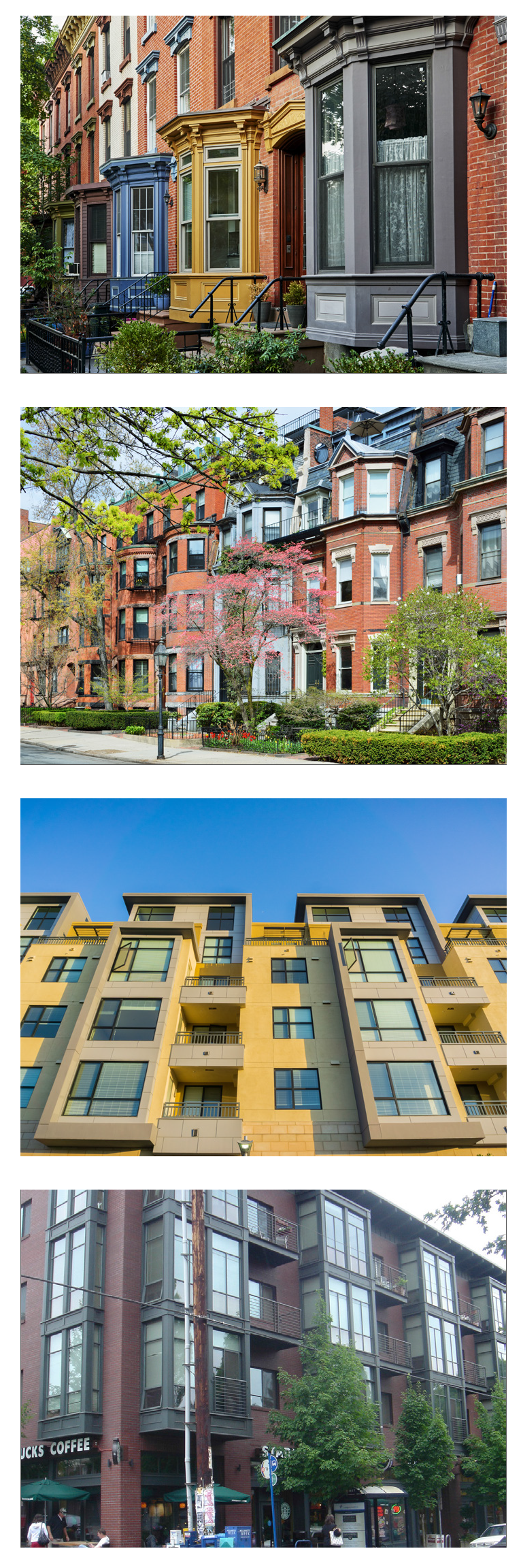
4.5Dv
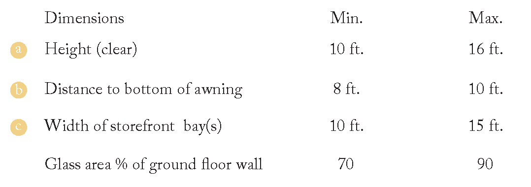
Shopfront
a)
Description: Shopfronts are large openings in a building facade that are enclosed with large transparent windows and doors that provide direct, at-grade access to ground floor commercial/retail uses. The basic required architectural elements of shopfronts include large windows, doors with glass, transom windows, and a solid base (bulkhead). Optional elements include awnings, canopies, signage, lighting, and cornices.
b)
Design Standards
i)
Storefront glass shall be clear without reflective coating or dark tinting. Lightly tinted glazing less than 15%, low emissivity, solar) is acceptable.
ii)
Shopfront shall be designed according to the following dimensional requirements:
4.5Dvi
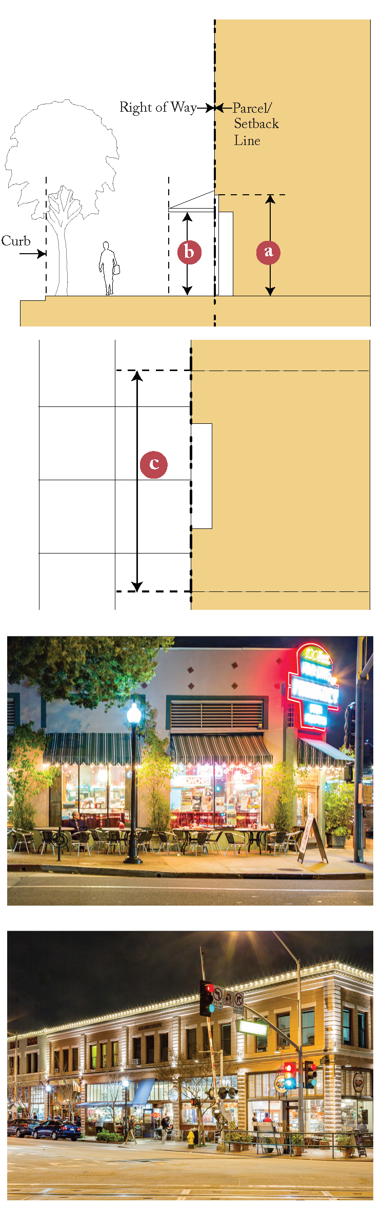
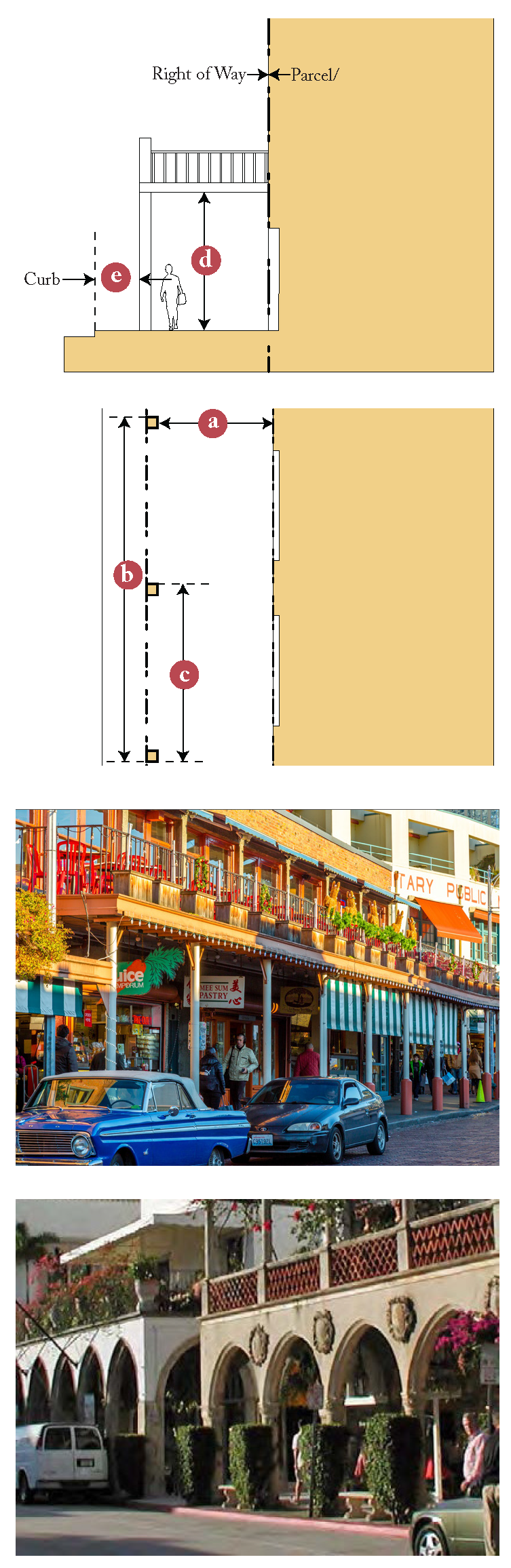
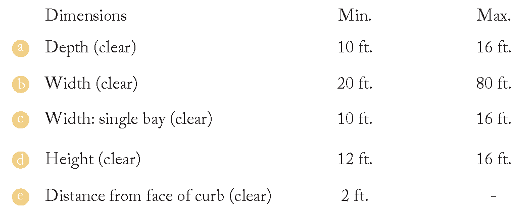
Gallery
a)
Description: Galleries are facades with ground floor colonnades that support a cantilevered shed roof or a deck that covers the sidewalk. Galleries contain ground floor storefronts, making them ideal for retail use. Railing on top of the gallery is only required if the gallery roof is accessible as a deck.
b)
Design Standards
i)
Along primary frontages, the Gallery columns shall correspond to Shopfront openings. Galleries shall be a minimum of two (2) bays wide.
ii)
Galleries shall be designed according to the following dimensional requirements:

4.5Dvii
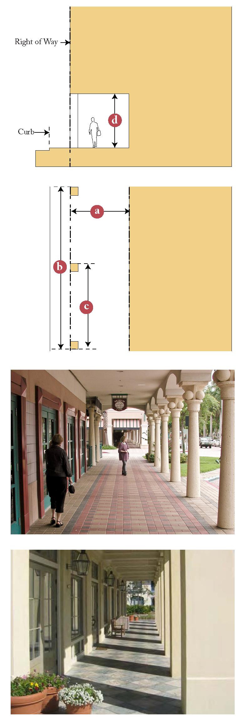
Arcade
a)
Description: Arcades are facades with a ground floor colonnade that supports the upper stories of the building, or for one-story buildings, the roof. Arcades contain ground-floor shopfronts, making them ideal for retail or restaurant use, as the arcade shelters the pedestrian while shading the storefront glass, preventing glare that might obscure views of merchandise.
b)
Design Standards
i)
Along primary frontages, the Arcade shall correspond to Shopfront openings. Arcades shall be a minimum of two (2) bays wide.
ii)
Arcades shall be designed according to the following dimensional requirements:
4.5Dviii
Balcony
a)
Description: A platform enclosed by a wall or balustrade on the outside of a building, with access from an upper-floor door.
b)
Design Standards
i)
Balcony design character, palette of materials, and approach to detailing shall be consistent and compatible with the building's style.
ii)
Balconies of traditionally styled buildings shall have visible supports in the form of projecting beams or braces. Balcony railings on traditional buildings shall be made of wood, wrought iron, steel bar or tube faithfully simulating true wrought iron. Balconies on modern styled buildings may simply project. Modern buildings may also use galvanized or painted steel, aluminum, and cable railing components. Vinyl substitutes shall be avoided.
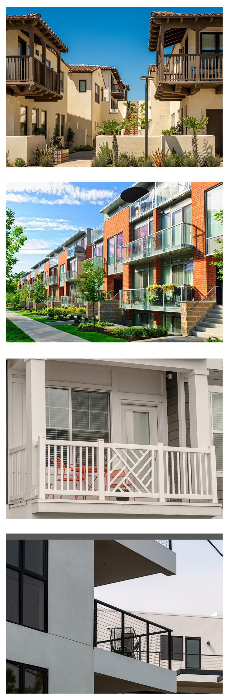
4.5Dix
Bay Window
a)
Description: A large window or series of windows projecting from the outer wall of a building and forming a recess within.
b)
Design Standards
i)
Bay windows shall be a maximum of ten (10) feet wide and shall have a height that is equal to or greater than their width.
ii)
Bay windows shall be placed a minimum of two (2) feet from any building corner and a minimum of three (3) from any other bay window.
iii)
Bay windows shall consist of at least 75% transparent fenestration.
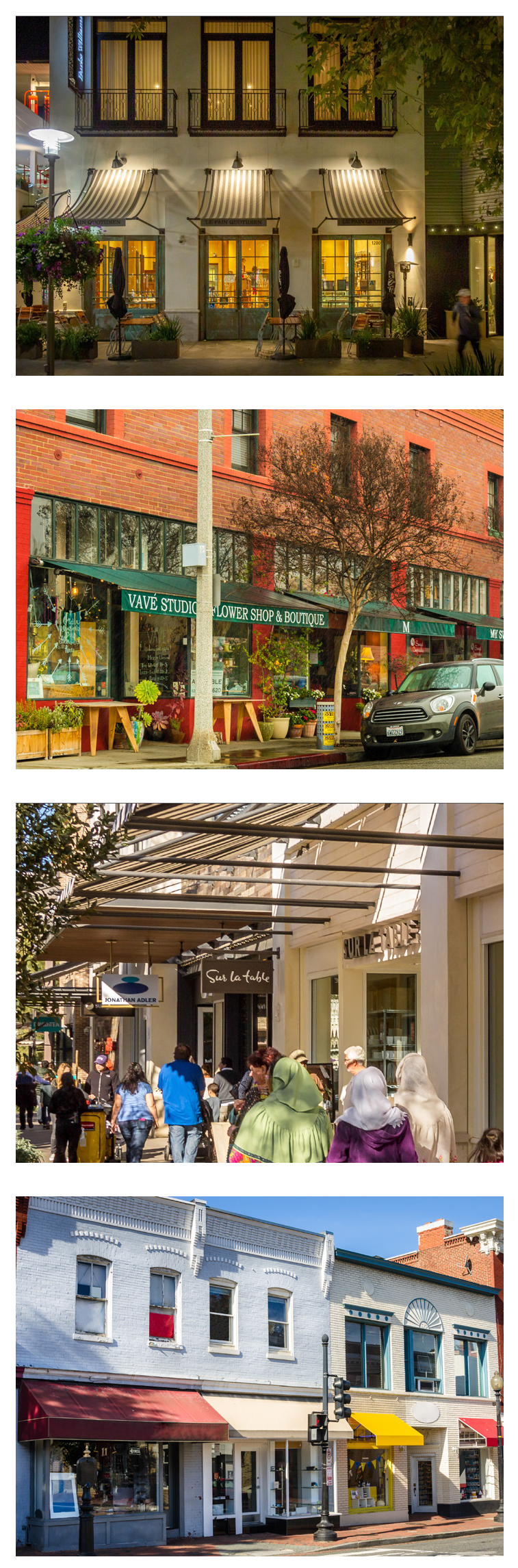
4.5Dx
Awning
a)
Description: A cloth cover fastened to a building or structure and supported by a frame that is used to protect pedestrians from the sun or rain.
b)
Design Standards
i)
Awnings shall be of a simple shed form, made of code-compliant fire-resistant canvas or materials of similar appearance; materials which are shiny, stiff, and synthetic shall be avoided.
ii)
Each awning shall correspond to a storefront.
iii)
Upper floor awnings may be provided. Each individual awning shall cover no more than one Shopfront or window opening. Signage is not permitted on upper floor awnings.
iv)
Awnings shall be positioned so that signage is not obstructed.
v)
Awning color(s) and pattern(s) shall be coordinated with the overall design of the building. As appropriate awning colors may vary between adjacent businesses.
vi)
Internally illuminated and backlit awnings and any associated light diffusers are prohibited.
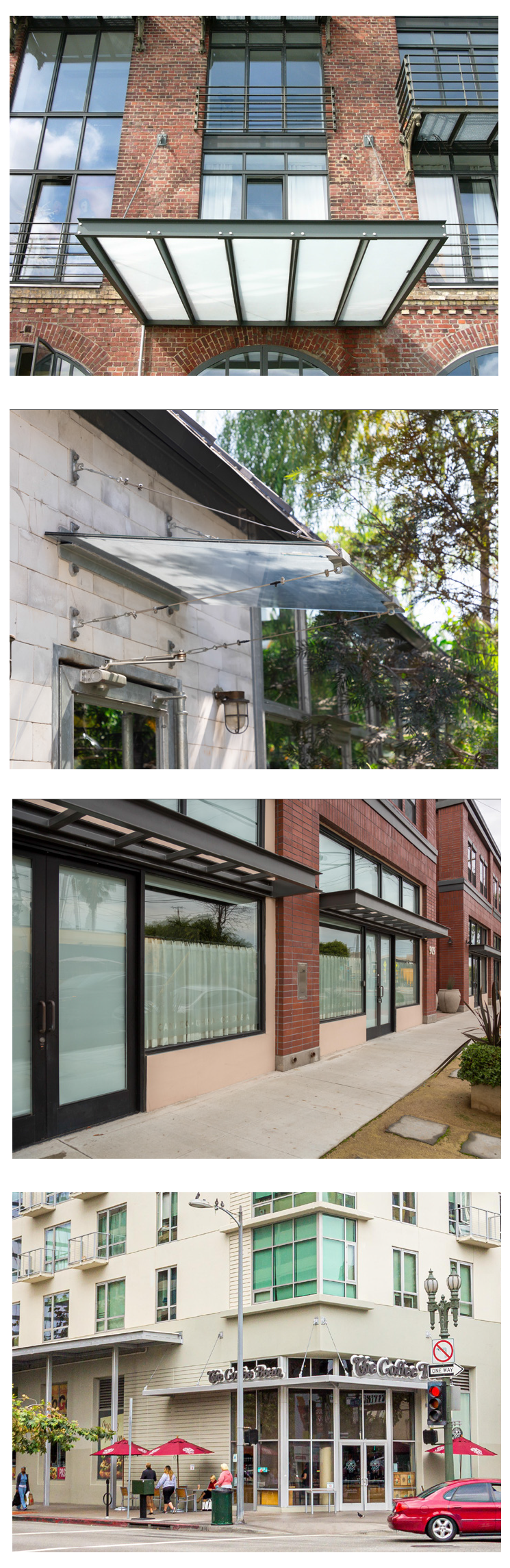
4.5Dxi
Canopy
a)
Description: A flat, metal awning that extends perpendicular from the building and parallel to the sidewalk. The canopy's frame is connected to the wall and spanned by a variety of materials, including metal lattice, glass, and metal slats.
b)
Design Standards
i)
Canopies shall be of a simple form, made of metal and/or glass.
ii)
Canopies shall be supported either from below by metal brackets, or from above by rods, wires, or chains that affix to the wall.
iii)
Canopies may extend across multiple storefronts.
iv)
Upper floor awnings may be provided. Each individual canopy shall cover no more than one window opening. Signage is not permitted on upper floor canopies.
v)
Canopies shall be positioned so that signage is not obstructed.
vi)
Canopies shall be coordinated with the overall design of the building; all canopies on a single building shall be consistent in their design, color, and material.
4.6 Land Uses
4.6A
Allowable Land Uses
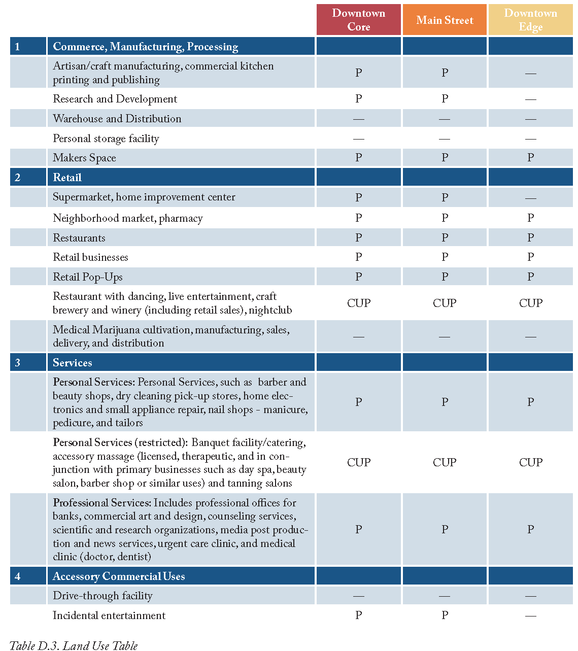
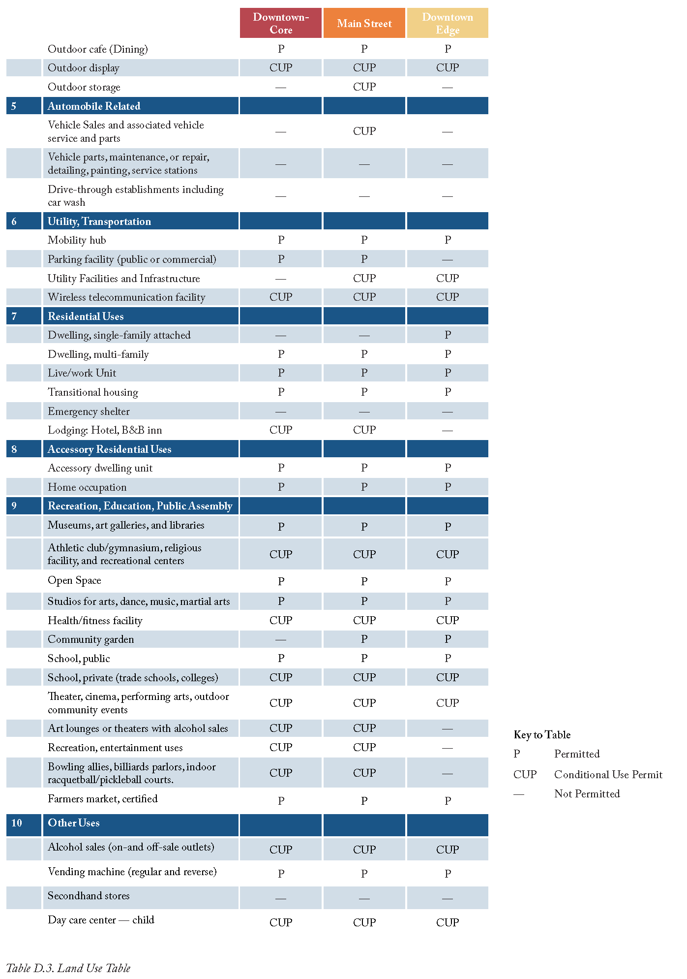
A parcel or building within the specific plan area shall be occupied by only the land uses allowed by Table D.3 within the zones specified within the Regulating Plan. Land uses are defined in Section 4.10B.ii (Glossary).
a
Use not listed. When a use is not specifically listed in Table D.3, the Planning and Community Development Director or his/her designee, shall have the authority to determine whether the proposed use is permitted based on the finding that the use is similar to, and no more detrimental than, those permitted in the zone. Uses not listed, or otherwise determined by the Planning and Community Development Director or his/her designee to be permitted, are prohibited.
4.6.B
Permit Requirements
a
Permitted subject to compliance with all applicable provisions of this Development Code, and a Site Plan in compliance with Zoning Code Title 17. These are shown as "P" uses in the tables;
b
Allowed subject to the approval of a Conditional Use Permit in compliance with Zoning Code Chapter 17.70, and shown as "CUP" uses in the tables; and
c
Not allowed in particular zones, and shown as a "—"in the tables.
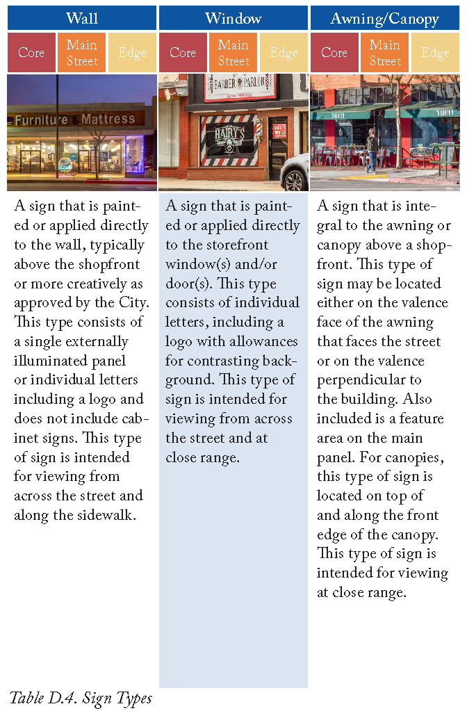
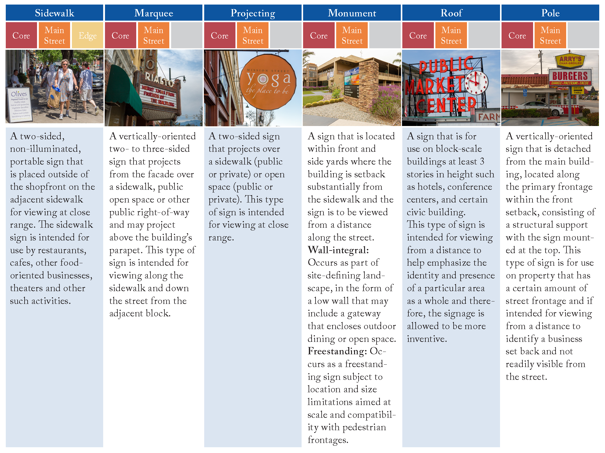
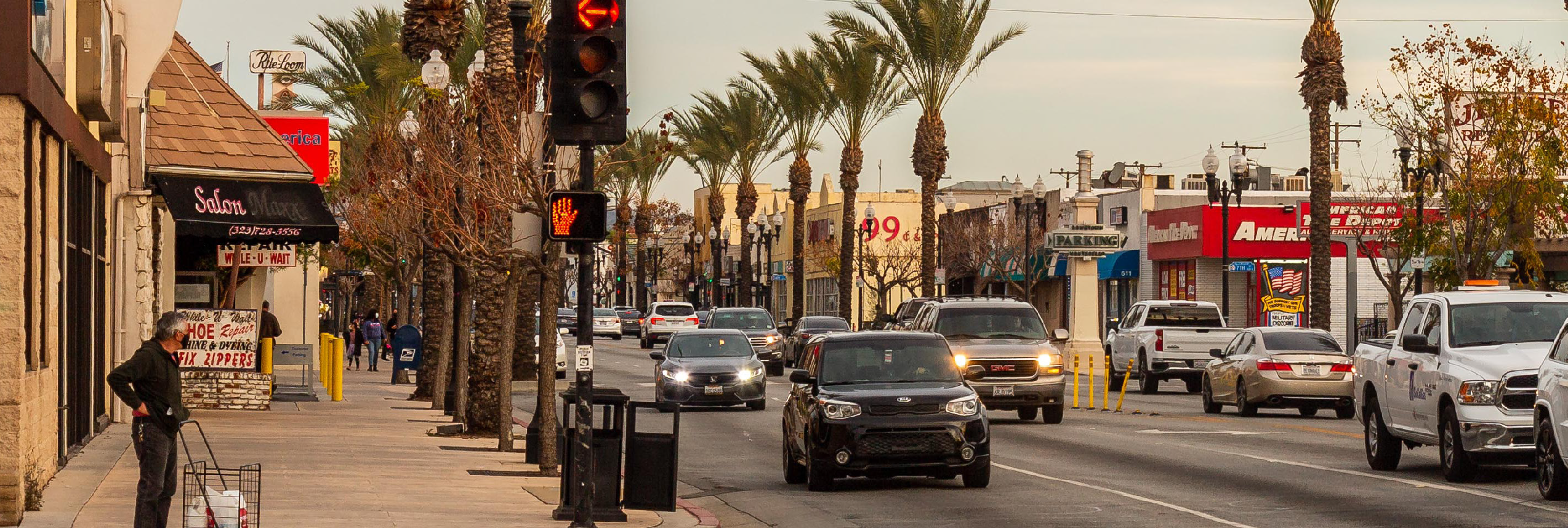
4.7 Signs
4.7A Sign Standards
4.7A.1
Purpose
These sign regulations are intended to appropriately limit the placement, type, size, and number of signs allowed within the Downtown area, and to require the proper maintenance of signs. The purposes of these limitations and requirements are to:
a
Avoid traffic safety hazards to motorists, bicyclists, and pedestrians, caused by visual distractions and obstructions;
b
Promote the aesthetic and environmental values of the community by providing for signs that do not impair the attractiveness of Downtown as a place to live, work, and shop; and
c
Provide for signs as an effective channel of communication, while ensuring that signs are aesthetically designed and proportioned in relation to adjacent structures and the structures to which they are attached.
4.7A.2
Applicability
a
Section 4.7 applies to all signage within the Downtown Code boundaries except for the following which are subject to the requirements of Chapter 17.62 of the Municipal Code:
1.
Real estate signs, special event signs, directional signs; and
2.
Billboard or other off-premise sign regulated by Chapter 17.62.105 of the Municipal Code, and any sign located in the public right-of-way and installed or maintained by the City or by any other public entity having legal authority to maintain signs.
b
Applicability to sign content. The provisions of this Section do not regulate the message content of a sign (sign copy), regardless of whether the message content is commercial or noncommercial.
c
Sign permit requirements. Installation of signs shall require approval of a sign permit:
1.
Wall, window, awning/canopy, and sidewalk signs shall be processed ministerially by the Planning and Community Development Director; and
2.
All other sign types shall be subject to Chapter 17.62 of the Municipal Code.

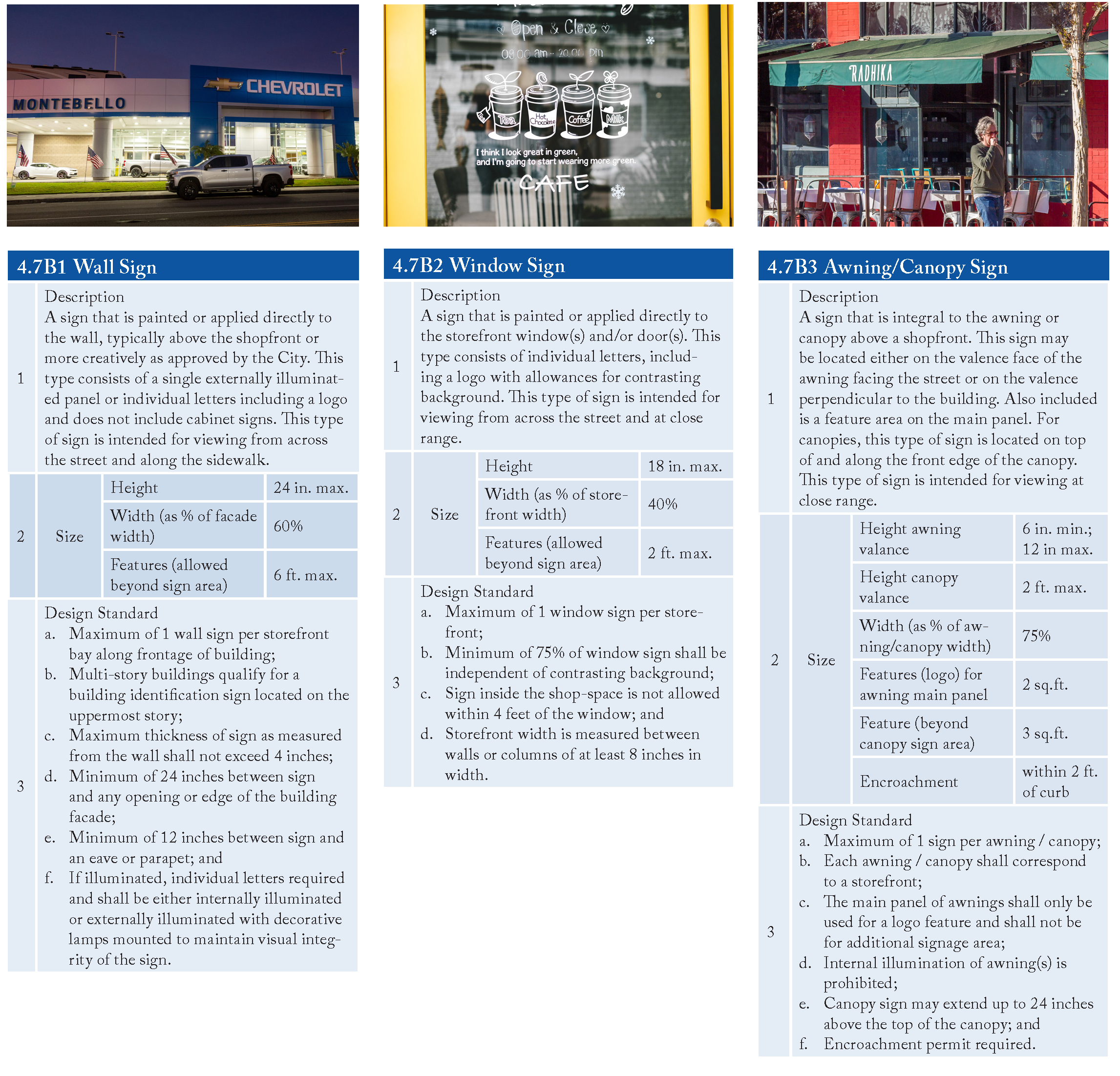
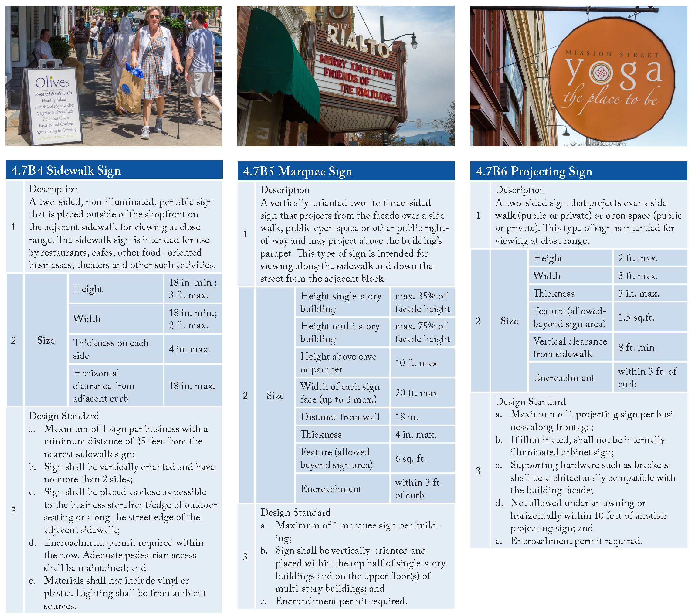
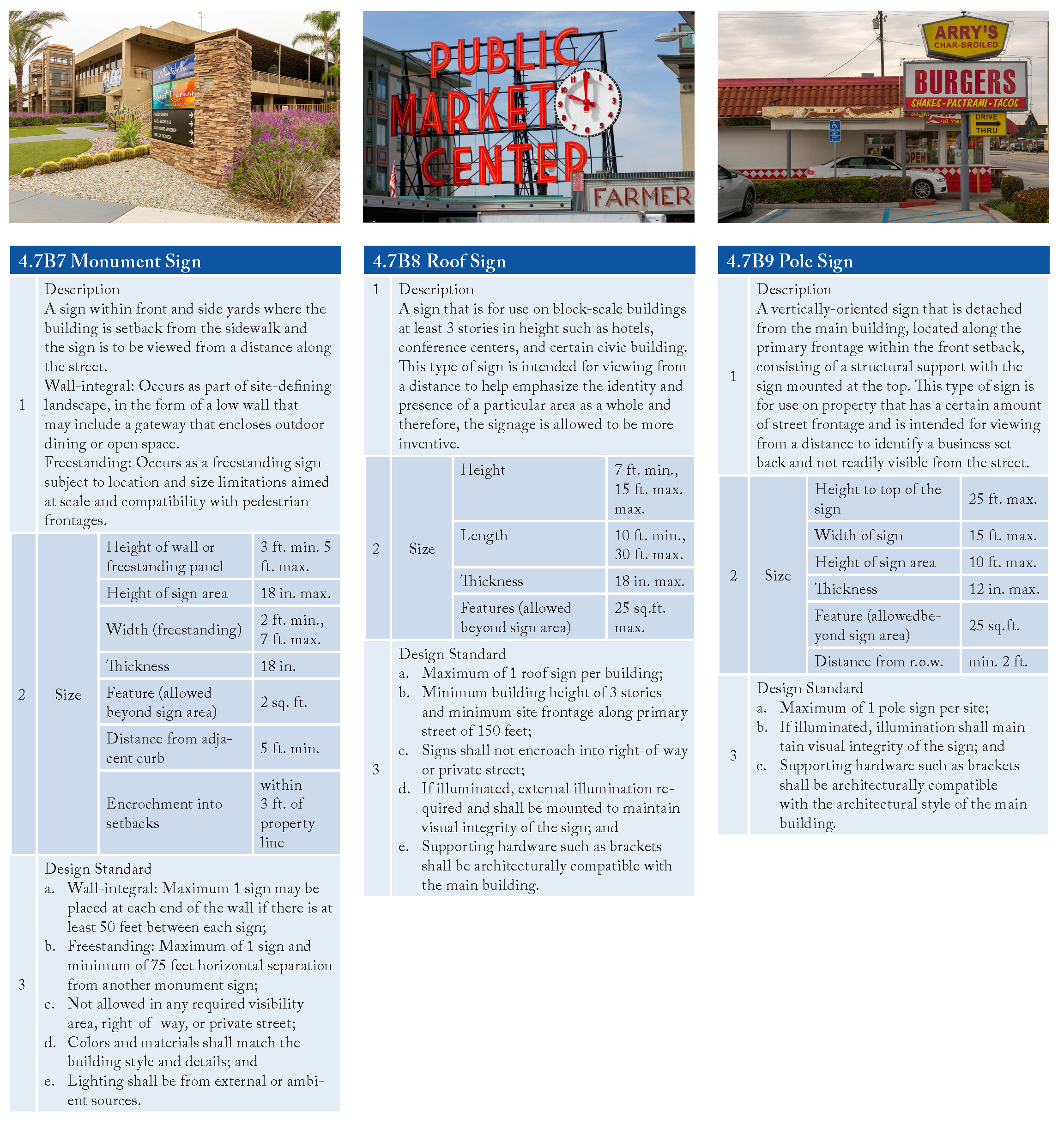
4.7B Sign Types
Each proposed sign or existing sign to be modified shall be designed as one of the signage types allowed for the zoning district as identified in Table 4.4


4.8 Other Development Standards
4.8A Parking Design
4.8A.1
Applicability
a
Parking required. Every use, including change or expansion of a use, or structure, shall have appropriately maintained parking and loading spaces or areas in compliance with the regulations identified in this section.
b
Number of parking spaces
i
Off-Street Parking Spaces. Off-street parking spaces shall be provided for each land use per the below standards:
a)
Residential: 1 space per unit (minimum).
b)
Residential Guest: 1 space for every 4 units (minimum)
c)
Lodging: 1 space per room (minimum).
d)
Live/Work: 1 space per unit under 1500 s.f.; if unit is greater than 1500 sq. ft.: 1 space for every 400 gross s.f.
e)
Office, Retail, Civic: 1 space per 300 gross s.f. of building area.
f)
Restaurants, Cafes, or similar: 1 space per 200 gross s.f. of building area.
c
On-Street Parking
i
On-street parking located along the development's frontage may be counted towards fulfilling the minimum number of spaces for the commercial component within the development up to twenty-five percent (25%) of the minimum required number of off-street parking spaces.
ii
In no case shall on-street parking be used for meeting minimum residential parking requirements within a mixed-use development.
iii
Where street parking spaces are counted toward meeting required on-site parking as allowed by this section, all such on street spaces must remain available for common use and not be exclusively assigned or reserved to any individual use.
4.8A.2
Parking Reduction Requirements
a
Shared Parking
Shared parking may be utilized as an effort to promote an overall reduction in parking. The amount of off-street parking required for a mixed use development may be reduced up to fifteen (15) percent as determined by the Planning and Community Development Director and approved by the Planning Commission when it can be demonstrated through a Parking Demand Study that sufficient parking is or can be met by the subject uses through a shared parking arrangement. Said study should explain the parking demands of the land uses within the development and how business practices or hours of operation impact the demand for parking at different times of the day.
b
Waiver of Parking
Any project site where it can be demonstrated that the land use thereon will not utilize the required number of parking spaces due to the nature of the specific land use, or the manner in which the specific land use is conducted, the number of parking spaces required may be reduced pursuant to the following:
i
Approval Required. A parking reduction based upon low parking demand may be allowed upon the approval of a Low Demand Parking Reduction Agreement by the City.
ii
Alternate Parking Plan. In approving a parking reduction, the City may require the preparation of an Alternate Off-Street Parking Plan, which demonstrates that additional parking spaces can be provided on-site, as necessary, to accommodate future land use changes or intensifications in land use. Furthermore, a restrictive covenant that runs with the land may be required by the City, which restricts the use of the subject property for the duration of the parking reduction.
iii
Low Demand Parking Reduction Agreement. A Low Demand Parking Reduction Agreement by and between the City, the applicant, and all other affected property owners, shall be executed and recorded with the County Recorder, which, at a minimum, shall:
a)
provide confirmation that the parking supply proposed will be adequate during periods of maximum demand,
b)
confirm that the parking demand is provided within a reasonable walking distance to the use it serves, and
c)
identify parking management strategies that are necessary to ensure the availability of the necessary number of parking spaces for the duration of the current use and future users of the project site. The Low Demand Parking Reduction Agreement shall be subject to City Attorney review and approval as to form and content.
iv
Parking Analysis. The City may require the applicant to submit a parking analysis, prepared by a person/firm experienced in preparing such analyses, to assist the City in determining the appropriate reduction.
4.8A.3
Parking Design and Development Standards
Required parking areas shall be designed and constructed as follows. The standards of this Section may be modified by the review authority where it determines that alternative parking designs and standards will more appropriately relate to the operating characteristics of the proposed development or new land use, while being equally effective in providing parking areas that are safe, convenient, use land efficiently, and are aesthetically attractive.
a
Access to Parking
i
Within the Specific Plan area, no new parking shall be placed between a building and a street, except where allowed adjacent to a side street in the residential zone.
ii
Parking, including parking garages, shall be accessed from an alley or secondary frontage when possible. The opening of a parking lot or garage on a frontage shall not exceed two lanes in width.
b
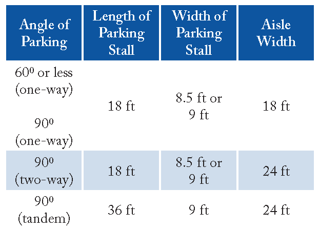
Tandem Parking. Tandem parking may be allowed at the discretion of the City:
i
Non-Residential Uses.
a)
The use of tandem parking for non-residential uses shall require that the operator of the parking facility provide a valet or attendant at all times that the parking is accessible to users, except where the City determines that the nature of the use and its operation will not require attended parking.
b)
Tandem parking shall be a maximum of two (2) parking spaces in depth.
c)
Vehicle movements necessary to move cars parked in a tandem configuration shall not take place on any public street.
ii
Residential Development. Tandem parking is allowed within multi-family projects and the residential component of mixed-use projects subject to the following standards:
a)
Up to thirty (30) percent of the total required off-street parking spaces may be provided in a tandem configuration. The maximum number of spaces permitted in a tandem configuration refers to the total individual spaces, not the total number of tandem spaces. For example, if twenty (20) total residential spaces are required, three (3) tandem space with two (2) cars in the tandem space for a total of six (6) individual spaces may be provided.
b)
Tandem parking shall be a maximum of two (2) parking spaces in depth.
c)
Both tandem spaces shall be assigned to the same dwelling unit.
d)
Vehicle movements necessary to move cars parked in a tandem configuration shall not take place on any public street.
e)
Guest parking spaces shall not be provided in a tandem configuration.
f)
When tandem parking spaces are used in private garages or other parking facilities with more than two (2) parking spaces, they shall be assigned and marked for resident use.
c
Disabled Parking Spaces. Parking spaces for the disabled shall be provided in compliance with the requirements of State Law (California Administrative Code [Title 24, Part 2, Chapters 2B71]. Disabled spaces required by this Section shall count toward fulfilling off-street parking requirements.
d
Loading Spaces
i
A minimum of one (1) off-street loading space shall be provided for every non-residential or mixed use building over 3,000 sq. ft. in gross area.
ii
Loading spaces shall be generally located at the rear of a building or along the alley when present in a fashion that allows for adequate maneuvering, loading, or unloading of vehicles without interfering with the orderly movement of traffic or pedestrians on the street.
iii
Off-street loading spaces may be striped "loading zone" by the City of Montebello as approved by the Planning and Community Development Director.
e
Parking space and lot dimensions. Parking lots and stalls shall be designed with the following minimum dimensions.
f
Landscaping. Parking areas shall be landscaped in compliance with the following requirements.
i
Surface parking areas shall be planted with shade trees at a minimum ratio of one tree for every four spaces in an orchard planting arrangement.
ii
Parking areas adjacent to a street or sidewalk shall be screened with landscaping and a decorative wall between 36 and 48 inches in height as approved by the review authority.
g
Lighting. Parking lot lighting shall comply with the following requirements:
i
Outdoor light fixtures shall be limited to a maximum height of 15 feet or the height of the nearest building, whichever is less.
ii
Lighting shall be energy-efficient, and shielded or recessed. Each light fixture shall be directed downward and away from adjoining properties and public rights-of-way.

h
Surfacing. The City desires to reduce stormwater run-off and water pollution, and to allow for the replenishment of groundwater. For parking areas, the goal is to reduce the amount of run-off generating surface area. Therefore, permeable surfaces for parking and maneuvering areas are encouraged. Acceptable permeable surfaces include:
i
Pervious pavers (products such as Unipaver, Eco-stone and SF Rima or an approved equivalent).
ii
Gravel, bark or grass when reinforced to provide adequate load-bearing (including geotechnical structures such as Invisible Structures' Grasspave and Gravelpave products, or an approved equivalent).
iii
Other permeable surfaces may be approved by the Public Works Director.
i
Passenger Loading and Unloading Zones. On-street, curb-side passenger loading and unloading zones, including for transit network companies (such as Uber and Lyft) are permitted as approved by the Planning and Community Development Director.
4.8B Solid Waste Standards
4.8B.1
Purpose
A successful solid waste collection and removal strategy will include appropriate accommodations for the collection, storage, access, and removal of solid waste and recyclable materials from the project site. Early planning to meet this requirement is essential to avoid major redesign of the project during later design phases and to ensure compliance with the standards and requirements of this Section.
4.8B.2
Location, Access and Design Criteria
The location of all solid waste collection and/or storage spaces shall meet the following requirements:
a
To the extent possible, collection/storage locations shall be accessed from an alley. Where an alley is not present, collection/storage locations may be accessed from the street. Collection/storage locations for corner lots shall be accessed from the Side Street.
b
The collection/storage space shall be located to minimize visual, noise, and odor impacts to adjacent building occupants both on the subject lot and on adjacent lots.
c
Outdoor trash enclosures or collection rooms within a structure shall not be located on a street-facing facade of the structure. Outdoor trash enclosures shall not be located between the building faced and the street.
d
The design of outdoor trash enclosures and exterior facing elements of a collection/storage area attached to, or within a building/structure, shall complement the architectural features of the building or development that they serve. The incorporation of landscaping around trash enclosures is encouraged as part of a successful design. All outdoor trash enclosures shall include a solid roof to minimize or prevent spilled or trash contaminants from entering the stormwater system.
e
The property owner or manager shall maintain both the interior spaces and surrounding exterior areas and keep them clean and free of graffiti, trash, residue, debris, and leaks.
4.8C
GHG Emissions Reductions Standards
The following design features shall be incorporated for all new development:
a.
Gas or propane fireplaces shall not be allowed in residential development.
b.
All residential development will provide outdoor electrical outlets to accommodate the use of electric landscape equipment.
c.
New development shall install at least one electric vehicle charging station on the specific project site, or through coordination with the City in other public parking areas within the City.
4.8D
Other Municipal Code Standards
All other requirements of the Municipal Code not specifically provided in the Downtown Montebello Specific Plan apply including, but not limited to, screening (i.e. rooftop mechanical equipment), trash enclosures, the installation of underground utilities.
4.8E Landscape and Outdoor Lighting Standards
4.8E.1
Landscape Materials: Context appropriate landscaping shall be provided for each project and designed to achieve an attractive "urban" landscape setting. Landscaping is also instrumental in creating and delineating public and private spaces. Appropriate landscaping will depend on factors such as the setbacks, shape, size, and orientation of the building.
a
Proposed developments shall incorporate site amenities such as linear planting beds or seat walls, street furniture, enhanced paving surfaces, public art, lighting, etc., where appropriate. These features should be architecturally compatible with the styles, materials and colors of the principal building on the lot and those in the immediate area.
b
Plant species should be selected based on their suitability for an urban environment, for their cleanliness, and for their ability to survive in a healthy state despite constrained growing conditions. Ease of maintenance should also be considered.
c
The majority of plant materials shall consist of drought tolerant and/or native plants with minimum water requirements.
d
The use of canopy trees for shading and cooling is encouraged where appropriate, particularly in publicly accessible open spaces and plazas, to mitigate the urban heat island effect. Where canopy trees are used, site design should provide sufficiently sized tree pits or planting beds and appropriate planting medium to provide for healthy tree growth.
e
Decorative water features shall use re-circulating water and, where available, shall use recycled water.
4.8E.2
Sustainable Storm Water Management: The intent of this Downtown Specific Plan is to create an urban walkable community. When fully implemented, the development of the Downtown planning area will result in an urban setting characterized by commercial, residential, and mixed use buildings, and structured or underground parking on sites with minimal to no landscape areas available at grade. In some cases, buildings could approach 100 percent coverage of the site. As part of the development review process, developers and their landscape architects will need to focus on tailoring each project to provide stormwater treatment facilities that are functional and visually attractive and that avoid the use of surface infiltration basins, which are not conducive to an urban setting. In preparing mandated Water Quality Management Plans (WQMPs) the following design guidelines shall be considered and implemented to the greatest extent possible:
a
Consider the range of BMP alternatives for drainage, infiltration, and stormwater quality for the site, including drainage from roofs, plazas, courts, and any surface parking areas.
b
Utilize Low Impact Development (LID) design principles and practices to address infiltration of runoff through the use of:
i
Pervious surfaces in lieu of impermeable surfaces in plazas, courtyards, and surface parking areas where technically feasible. Acceptable pervious surfaces include: landscaping; pervious pavers including pervious interlocking pavers and permeable concrete; etc.; as approved by the Planning and Community Development Director and Public Works Director.
ii
Landscaped areas integrated into the drainage design where runoff can be directed into planters with subsurface features to further enhance storage or towards permeable surfaces where technically feasible. Amended soils shall be utilized where technically feasible to enhance infiltration, to provide water quality improvement, and to maintain healthy plant life.
c
Surface infiltration basins are not allowed, unless:
i
They are accommodated within an active or passive park or open space that can be closed during flood events.
ii
They are not visible from a street or public open space and they are in addition to the required on-site open space.
4.8E.3
Site Lighting
a
Site lighting should be shielded by permanent attachments to light fixtures so that light sources are not visible from a public way and to prevent off-site glare.
4.9 Administration
4.9A
Review Authority
The standards and other requirements of this Development Code shall be administered and enforced by the Planning Division of the Montebello Planning and Community Development Department, the Planning Commission, and City Council in the same manner as the provisions of the City's Zoning Code.
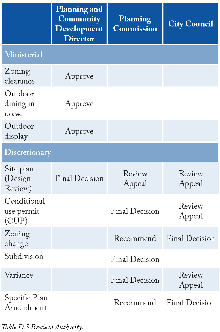
a
Chapter 17.74 of the Municipal Code specifies standards for Site Plan Review application. The following types of applications shall be reviewed and acted upon by the identified body or individual:
i.
Ministerial Applications: The Planning and Community Development Director review shall be the Review Authority for ministerial applications as listed in Table 4.5.
ii.
Discretionary Applications: Discretionary application shall be reviewed as listed in Table D.5.
4.9.B
Minor Deviations
a
A Minor Deviation permits a design solution that is not consistent with a specific provision of this Development Code, but is justified by its ability to fulfill this Specific Plan's intent while not compromising its vision and intent.
b
All development standards within this Development Code may deviate up to a maximum often percent (10%).
c
Minor Deviations are subject to Planning and Community Development Director review prior to Planning Commission consideration.
4.9.C
Compatibility and Architectural Review
For the purposes of maintaining consistency with this Specific Plan; establishing a high standard of architectural quality and design variety; and maintaining compatibility with adjoining properties, all development applications within the Downtown Specific Plan area will be subject to an external peer review. Such a review will be conducted by an architect, urban designer, or planner in private practice, as chosen by the review authority (City). The review authority shall establish fees and procedures for such review.
4.9D
Treatment of Potential Historic Resource
a
Prior to completion of the Historic Resource Survey, applications for all demolition permit and development proposals involving structures over 50 years in age will include a historic, technical assessment or "Phase I" prepared by a City-designated historic professional.
b
Upon reviewing a "Phase I" historic assessment, the Planning and Community Development Director may request additional documentation in the form of a Phase II study.
c
Planning and Community Development Department staff shall evaluate the Phase I and/or Phase II to determine whether the application involves a Historic Resource as defined by CEQA.
d
If the Director determines a potential Historic Resource is present, but not formally designated as a landmark or already on a State or Federal register, the development proposal shall be reviewed by the Planning Commission for compliance with the Secretary of the Interior's Standards and Guidelines for the Treatment of Historic Properties.
4.10 Glossary
4.10A
Purpose
This Section provides definitions of terms and phrases used in this Development Code that are technical or specialized, or that may not reflect common usage. If any of the definitions in this Section conflict with definitions in the Zoning Code or other provisions of the Municipal Code, these definitions shall control for the purposes of this Development Code. If a word is not defined in this Section, or in other provisions of the Montebello Municipal Code, the Planning and Community Development Director shall determine the correct definition.
4.10B
Definitions of Specialized Terms and Phrases
As used in this Development Code, each of the following terms and phrases shall have the meaning ascribed to them in this Section, unless the context in which they are used clearly requires otherwise.
4.10Bi
Definitions of General Terms
4.10B.ii
Definitions Of Land Use Terms