
Tulsa City Zoning Code
CHAPTER 20
- OVERLAY DISTRICTS
Section 20.010.- General.
A.
Purpose and intent. As the name implies, overlay districts "over-lay" applicable base zoning district classifications to alter some or all of the base zoning district regulations that apply to particular sites. Overlay zoning districts work to modify or supplement the regulations imposed by base zoning district when necessary to address special situations or accomplish specific city goals. Overlay zoning is intended to be used when the base zoning district applied to an area remains generally appropriate, but when an additional, modified or eliminated requirement could help implement the City's planning goals or address an area-specific planning, design or land use regulation issue.
B.
Establishment and public engagement
1.
A pre-application meeting is required before the filing of any owner-initiated overlay district application (see Subsection 70.010C.2).
2.
Proposed regulations and overlay district boundaries must be based on an adopted plan or be prepared following an inclusive, transparent, and equitable planning and public involvement process that includes opportunities for affected property owners and residents to participate in the formulation of the district regulations or otherwise offer recommendations and provide input.
3.
At the time of the public hearing to consider adoption of an overlay district, the applicant must document the public involvement process used in preparing the proposed regulations and district boundaries, by providing at least the following information:
a.
The opportunities provided for participation and input;
b.
The types of information disseminated to affected residents, businesses and property owners and the methods of dissemination;
c.
The level of participation by affected residents, businesses and property owners in meetings and discussions; and
d.
The level of support shown by affected residents, businesses and property owners for the proposed regulations and overlay district boundaries.
C.
Interpretation.
1.
All applicable regulations of the underlying base zoning district apply to property in an overlay district unless otherwise expressly stated in the overlay district regulations.
2.
When overlay regulations conflict with regulations that otherwise apply in the underlying base zoning district, the regulations of the applicable overlay govern. If property is classified in multiple overlay districts and the regulations of one overlay district conflict with the regulations of another overlay district, the more restrictive regulations govern.
D.
Procedure. Overlay districts are shown on the official zoning map. The following procedures apply to the establishment, amendment or termination of all overlay districts unless otherwise expressly stated:
1.
Overlay district regulations must be established, amended or terminated in accordance with the zoning code text amendment procedures of Section 70.020.
2.
Except as otherwise expressly stated, zoning map amendments establishing, expanding or reducing the boundaries of an overlay district or terminating all or part of an overlay district must be processed in accordance with the zoning map amendment procedures of Section 70.030.
3.
A recommendation to establish an overlay district must be accompanied by a report containing at least the following information:
a.
Specific findings regarding the need for the proposed overlay and its consistency with the zoning code's general purposes (Section 1.050) and the stated purpose and intent of the applicable overlay.
b.
Any recommended overlay-specific use, development or design regulations that will apply within the overlay and what actions (e.g., new development, building additions, change of use) will trigger compliance with those regulations.
c.
A description of public education and outreach activities undertaken to inform property owners, residents and tenants of the effect of proposed overlay regulations.
d.
A map showing the boundaries of the proposed overlay, including all lots included within the boundaries and identifying those owners of property within the proposed overlay who have indicated, in writing, their support or opposition to the overlay district text or map amendment. Property owners may submit their written indication of support or opposition at informal informational meetings, at public hearings, or by writing directly to the land use administrator or planning commission. The report and all other pertinent information must be transmitted to the planning commission and City Council before their public hearing and final action, respectively.
Section 20.020. - HP, Historic Preservation overlays.
A.
Purposes. HP, Historic Preservation overlay districts and the other historic preservation-related regulations of this zoning code are intended to:
1.
Promote the educational, cultural, economic and general welfare of the public through the conservation, preservation, protection and regulation of historic resources within the City of Tulsa;
2.
Safeguard the cultural, social, political and architectural heritage of the city by conserving, preserving and regulating historic preservation districts;
3.
Conserve, preserve and enhance the environmental quality and economic value of historic preservation districts;
4.
Strengthen the city's economic base by promotion of conservation and reuse of the City's historic resources; and
5.
Promote the development of the community in accordance with the comprehensive plan and historic preservation plan.
B.
Use regulations. The use regulations of the underlying base zoning district apply in HP overlay districts.
C.
Lot and building regulations. The lot and building regulations of the underlying base zoning district apply in HP overlay districts.
D.
Design Guidelines. Design guidelines governing the applicable HP zoning district must be adopted before or concurrent with any HP zoning map amendments. When the boundaries of an HP zoning map amendment include a City of Tulsa park, design guidelines governing the applicable HP zoning district must identify the historic resources within the park.
E.
Establishment or amendment of HP overlay districts See Subsection 20.010D. and Section 70.060 for procedures and requirements governing establishment or amendment of HP overlay districts.
F.
HP permits. See Section 70.070 for requirements and procedures governing the review and approval of HP permits in HP overlay districts.
(Ord. No. 25212, § 1, 12-20-2023)
Section 20.030. - SA, Special Area overlays.
A.
General. This section establishes the general authority and basic procedure for establishment of SA, Special Area overlay districts. Historic Preservation Overlays (HP), Parking Impact Overlays (PI) and Planned Unit Developments (PUD) are not considered SA overlays.
B.
Purpose and intended use.
1.
SA overlays are intended to address neighborhood planning and design issues when other available zoning tools or other techniques cannot achieve the desired results. SA overlays may be used to relax or eliminate requirements that apply under base zoning or to impose requirements in addition to those of base zoning. SA overlays are not intended to be used as a de facto downzoning tool. SA overlays may be appropriate for one or more of the following purposes:
a.
Protect unique development, building or land use patterns in residential, commercial or mixed-use areas when such patterns are not adequately addressed by applicable zoning regulations;
b.
Promote reinvestment and redevelopment in residential, commercial or mixed-use areas where change is desired and when existing zoning regulations hinder achievement of the desired change; or
c.
Help implement neighborhood plans or planning studies.
2.
Without limiting the general purpose and intent of Subsection 20.030B.1., SA overlays may be used for the following express purposes:
a.
Allow principal or accessory uses and building types that are not allowed under base zoning;
b.
Allow densities and intensities of development that are not allowed under base zoning; or
c.
Establish reasonable, clear and objective site, building and design standards that promote the general purpose established in Subsection 20.030B.1.
3.
SA overlays may not be used to impose requirements that conflict with the comprehensive plan or any other officially adopted plan.
C.
Underlying Zoning. SA overlays may be approved in areas classified in any residential or nonresidential base zoning district, except the Central Business District (CBD). SA overlays may not be applied in combination with Central Business District (CBD) zoning.
D.
Minimum contiguous areas. SA overlay district boundaries must encompass at least ten (10) lots, and in all cases must include at least one acre of contiguous land area. Smaller areas may be designated as SA overlays if they abut and extend an existing SA overlay district or if they include all lots within an original subdivision plat.
(Ord. No. 25055, §§ 6, 7, 5-24-2023; Ord. No. 25322, § 2, 5-22-24; Ord. No. 25330, § 5, 6-5-2024)
Section 20.040. - PI, Parking Impact overlay.
A.
Purpose. The purpose of the Parking Impact (PI) overlay district is to provide supplemental parking regulations for specified areas experiencing negative impacts due to the relative absence of parking, transit and alternative transportation mode choices. The intent of the PI overlay is to identify areas of high parking demand and increase the off-street parking requirements accordingly.
B.
Underlying zoning. The PI overlay may be approved in areas classified in any underlying base zoning district.
C.
Regulations. Special parking requirements apply to many uses located within the boundaries of the PI overlay, in accordance with the minimum off-street parking ratios of Section 55.020.
Section 20.050. - RDO, River Design overlays.
A.
General.
1.
Purpose and intent. The RDO, River Design overlay regulations of this section establish regulations governing form, function, design and use for properties located within the boundaries of the River Design overlay district. The regulations are generally intended to maintain and promote the Arkansas River corridor as a valuable asset to the City and region in terms of economic development and quality of life. The regulations are also intended to:
a.
Support and enhance the river corridor as a lively people-oriented destination, connecting nodes of high-quality development with parks and open spaces;
b.
Protect the City's investment as well as the investments of property owners, developers and others who enjoy the benefits of the Arkansas River corridor;
c.
Encourage development that enhances the appearance of the Arkansas River corridor and the surrounding area;
d.
Ensure development and redevelopment that is sensitive to the area's natural resources and environmental qualities;
e.
Establish the area as an interconnected, pedestrian-oriented, cultural and recreational destination, attracting both residents and visitors to the Arkansas River; and
f.
Foster a sense of community and civic pride.
2.
Districts. Three (3) RDO districts are established, as follows:
a.
RDO-1. The RDO-1 district is primarily intended to apply to park, recreation and open space uses adjacent to the river. RDO-1 regulations help promote development that is compatible with public parks and green space and that complements park uses.
b.
RDO-2. The RDO-2 district is primarily intended to apply to other (non-RDO-1) properties with direct access to the river. RDO-2 regulations help to ensure safe, attractive and activated pedestrian areas by requiring that new development is oriented to the river and abutting streets. The regulations also promote integration with the River Parks trail system and avoidance of adverse environmental impacts.
c.
RDO-3. The RDO-3 district is primarily intended to apply to properties that do not have direct access to the river but that are visible from riverfront areas. These areas benefit from proximity to the river and contribute to the overall visual environment of the riverfront area.
3.
Applicability. Except as otherwise expressly stated, the RDO regulations of this section apply within the boundaries of the RDO overlay districts to all new uses and structures and all building alterations and site modifications that require a building permit.
4.
Exemptions.
a.
Existing detached houses and duplexes and additions to existing detached houses and duplexes are exempt from compliance with all of the RDO regulations of this section (Section 20.050).
b.
Uses and structures that are accessory to existing or new detached houses or duplexes are exempt from compliance with all of the RDO regulations of this section (Section 20.050).
c.
New detached houses and duplexes, where allowed, are exempt from compliance with all of the site and building design regulations of Subsection 20.050C.
d.
New or modified public utility and service uses and accessory uses customarily incidental to park and recreation uses (excluding restaurants) are exempt from compliance with the:
(1)
Build-to-zone regulations of Table 20-2;
(2)
Ground floor transparency regulations of Table 20-3; and
(3)
Building entrance requirements of Table 20-3.
e.
Planned unit developments (PUDs) and CO-zoned properties or portions of PUDs and CO-zoned properties that have received site plan approval prior to August 1, 2016 are exempt from compliance with all RDO regulations of this section (Section 20.050). Approved PUDs and CO-zoned properties or portions of PUDs and CO-zoned properties that have not received site plan approval prior to August 1, 2016 are subject to compliance with all applicable RDO regulations of this section (Section 20.050).
f.
Minor revisions of previously approved site plans do not trigger a requirement that the site plan be brought into compliance with the RDO regulations of this section. Major and minor amendments to approved development plans do trigger a requirement that the entire development plan be brought into compliance with all applicable RDO regulations of this section (Section 20.050).
5.
Nonconformities.
a.
General. Nonconformities that exist within an RDO district are governed by the regulations of Chapter 80, except as expressly stated in this subsection.
b.
Restoration, Replacement, Alteration and Expansion of Nonconforming Uses and Structures (other than signs).
(1)
Structures and uses that are nonconforming with regard to the RDO regulations of this section (Section 20.050) may be restored, replaced, altered or expanded, and additional structures that are nonconforming with regard to the regulations of this section (Section 20.050) may be constructed, provided that the restoration, replacement, alteration, expansion, or additional construction does not increase by more than fifty (50) percent of the total floor area or lot coverage of a nonconforming use or increase by more than fifty (50) percent of the total lot coverage of nonconforming structures. Restoration, replacement, alterations, expansions, and additions allowed under this paragraph are not required to comply with the site and building design regulations of Subsection 20.050C. For purposes of this Subsection 20.050A.5. "structure" does not mean "sign". For purposes of this Subsection 20.050A.5., the increase in percentage of total floor area or total lot coverage is calculated using the total floor area or total lot coverage in existence on the date the structure or use became nonconforming.
(2)
An existing structure and all replacements, restorations, expansions, alterations and additions must be brought into compliance with the site and building design regulations of Subsection 20.050C. under the following circumstances:
(a)
More than fifty percent (50%) of a nonconforming structure is proposed to be replaced or restored; or
(b)
A nonconforming structure is proposed to be altered or expanded by more than fifty percent (50%); or
(c)
Additional structure(s) are proposed to be constructed resulting in a more than fifty percent (50%) increase in the floor area or lot coverage, as described in Subsection 20.050A.5.b.(1).
(3)
For purposes of administering these restoration, replacement, alteration and expansion regulations, increases in floor area and lot coverage are calculated separately; they are not added together to determine whether the fifty (50) percent threshold has been met. A complete building permit application for any restoration or replacement must be submitted within five (5) years of the date a nonconforming building was damaged, destroyed or removed.
6.
Conflicting regulations. All applicable regulations of the underlying base zoning district apply to property in the RDO district unless otherwise expressly stated in the RDO regulations. For properties with PUD or CO zoning, the approved development plan or development standards governing the subject PUD or CO district apply unless otherwise expressly stated in the RDO regulations. If the regulations of the RDO district conflict with the regulations of the subject property's underlying zoning, approved development plan or development standards or any other overlay zoning district that applies to the property, the RDO regulations of Section 20.050 govern, unless otherwise expressly stated.
7.
Modifications to RDO regulations.
a.
The land use administrator may grant administrative adjustments to provisions in this Section 20.050 in accordance with Section 70.100.
b.
The Board of Adjustment may modify the build-to-zone regulations in Table 20-2, the transparency regulations in Table 20-3 and the parking regulations in Subsection 20.050D.2.b.(3) through the special exception process provided that the Board of Adjustment finds the special exception will be in harmony with the spirit and intent of the zoning code, including the spirit and intent of this Section 20.050 and will not be injurious to the neighborhood or otherwise detrimental to the public welfare.
c.
The regulations of an RDO district may not be varied or modified through approval of or amendment of a Planned Unit Development (PUD) district or Corridor (CO) district.
d.
The regulations of an RDO district may not be varied or modified through approval of or amendment of a Master Plan Development (MPD) district except that in an MPD with a minimum area of twenty (20) acres, the build-to-zone regulations in Table 20-2 may be modified. If the build-to-zone in the MPD is modified, the MPD must demonstrate activation along the trail and/or street edge through the use of other principles of the RDO. The MPD must meet all other RDO provisions and remain consistent with the purpose and intent of both the RDO and the MPD.
8.
Administration. No building permit for proposed use or development in an RDO district may be approved until a site plan for such use or development has been submitted and reviewed by the land use administrator and found to be in compliance with all applicable RDO regulations.
B.
Uses.
1.
Intent. The RDO regulations are intended to allow for a mix of uses to promote a pedestrian environment, while prohibiting uses that will hinder the long-term viability of an attractive, vibrant and active riverfront area.
2.
Regulations.
a.
Allowed uses. Except as expressly identified in Table 20-1, principal uses are allowed in RDO districts in accordance with the use regulations of the underlying (base) zoning district or, in the case of PUD or CO zoning, in accordance with the approved development plan or development standards governing the subject PUD or CO district. Uses identified with a "□" symbol are allowed in the respective RDO district: (1) if allowed by the subject property's underlying (base) zoning district or (2) if the subject property has PUD or CO zoning, if the use is allowed by the approved development plan or development standards governing the subject PUD or CO district.
b.
Prohibited uses. Uses identified with an "X" Table 20-1 are expressly prohibited in the respective RDO district.
Table 20-1: RDO District Use Regulations
[1]
Use allowed above the ground-floor level only.
[2]
Use limited to water and wastewater treatment facilities (Special Exception required).
C.
Residential Building Types. Residential uses allowed in RDO districts must be located in residential buildings as allowed in the underlying zoning district, except as prohibited by Table 20.1-5. Descriptions of the residential building types and references to applicable regulations are found in Section 35.010.
Table 20-1.5: RDO Building Type Regulations for Household Living
[1]
Detached houses and duplexes are allowed when part of a planned unit development that was approved before January 1, 2016.
D.
Site and Building Design.
1.
Building Placement, Building Design and Site Features.
a.
Intent. The building placement, building design and site design regulations of this section are intended to:
(1)
Ensure that buildings are oriented to face pedestrian areas along the river and abutting streets;
(2)
Create and frame usable outdoor spaces;
(3)
Encourage pedestrian activity by creating compact and well-connected development;
(4)
Ensure that new development is constructed of durable, long-lasting materials;
(5)
Enhance pedestrian interaction with the natural and built environment by providing building articulation and transparency of building façades at pedestrian levels; and
(6)
Promote incorporation of design features that encourage outdoor activity and emphasize the presence of the river and parkland.
b.
Siting of buildings, parking and service areas. Buildings, parking and service/equipment areas are subject to the regulations of Table 20-2.
Table 20-2: RDO Building, Parking and Service Area Siting [1]
[1]
General rules for measuring compliance and exceptions to these regulations and can be found in Chapter 90.
[2]
"Dual river trail" refers to the split or divided public trail that runs generally parallel to the river and that provides separate hard-surfaced areas for cyclists and pedestrians. [Note: Not all portions of the dual river trail are designed as separate/divided trails.] BTZ measurements are taken from the edge of the dual river trail surface located furthest from the river.
[3]
Maximum may be increased to 150 feet if occupied by a pedestrian activity area or outdoor dining/entertainment venue.
[4]
Top of river bank BTZ and setback requirements apply only if dual river trail is not in place. Buildings that project beyond the top of the river bank are exempt from BTZ requirements. The geographic "river bank" refers generally to the land alongside the bed of the river. The top of the river bank must be dimensionally defined on the site plan that is submitted to and approved by the land use administrator during the development/permit review process. The top of bank will generally be interpreted as the highest point where the steepest slope of the bank intersects with the flattest surface further away from the river. The 100-year flood elevation is typically below the top of the bank.
[5]
Maximum may be increased to 200 feet if occupied by a pedestrian activity area or outdoor dining/entertainment venue.
[6]
Buildings are not required to meet both river and major street BTZ requirements. Buildings must first comply with river BTZ requirements.
[7]
In RDO-2, Pedestrian activity areas and outdoor dining/entertainment venues may be counted to meet up to 30% of the river BTZ requirement, provided that if multiple buildings on a lot are located within the river BTZ, the cumulative total of all pedestrian activity and outdoor dining/entertainment areas may not exceed 30% for the purpose of determining the river BTZ. Once buildings occupy at least 70% of the length of the river BTZ, additional buildings may be constructed in the major street BTZ. Once 70% of the length of the river BTZ and 50% of the length of the major street BTZ of a lot is occupied by building(s), any additional building(s) on that lot is not required to be located within a BTZ.
[8]
In RDO-3, buildings must first comply with major street BTZ requirements. Once 50% of the length of the major street BTZ of a lot is occupied by building(s), any additional building(s) on that lot is not required to be located in a BTZ.
[9]
For purposes administering and interpreting these regulations, a "façade" is an exterior wall of a building.
[10]
Drive aisles that are parallel or generally parallel to the river must be lined by a parking aisle on the river side of the property.
c.
Facades. Facades are subject to the regulations of Table 20-3.
Table 20-3: RDO Facade Regulations
[1]
Residential buildings are exempt from ground-floor transparency requirements.
[2]
Buildings entrance requirements do not apply to river-facing façades if the building projects beyond the top of the river bank. The land use administrator is authorized to waive the trail direct connection requirement when the subject portion of the trail is in different ownership and access rights cannot be obtained.
Figure 20-1: River BTZ, Setback and Facade Regulations
Figure 20-2: Street BTZ, Setback and Facade Regulations
Figure 20-3: Building and Parking Placement (1)
Figure 20-4: Building and Parking Placement (2)
d.
Building design.
(1)
Exterior insulation and finish systems (EIFS) or simulated stucco may not be used on more than fifteen (15) percent of any building façade and may not be used on the ground-floor level façade.
(2)
Vinyl siding and aluminum siding are prohibited building materials.
(3)
Blank walls without architectural detailing/articulation may not exceed thirty-five (35) feet in height or width. Articulation must be provided as a means of breaking the building face into separate visually distinct but attached or adjoining pieces by using a different building materials, transparency, openings or by recesses or projections in facades.
e.
Parking structures.
(1)
Parking structures must be designed to visually conceal ground-floor level parking through the use of architectural detailing or liner buildings.
(2)
Ramped and sloping interior floors must be concealed from view of the public street and the river.
(3)
Stairwells must be built and located on the exterior corners of parking garages and constructed so that at least one wall of the stairwell be visually open to the outdoors. Additional interior stairs may be allowed adjacent to elevators, but one side must remain visually open.
(4)
Screening walls to conceal ramps, slopes and vehicles absent architectural detailing/articulation at expanses greater than thirty-five (35) feet are prohibited.
f.
Site features.
(1)
All new utility services, such as telephone, electrical and cable services, must be installed underground.
(2)
Utility components required to be above ground, such as transformers and meters, must either be screened by landscaping or decorative wall or concealed from view of the public street and the river.
2.
Parking.
a.
Intent. The parking-related provisions of this subsection are intended:
(1)
To minimize the visual prominence of parking, promoting increased pedestrian activity and enhancing the overall appearance of development; and
(2)
To support more urban development intensities through reduced parking minimums and other flexible parking regulations.
b.
Regulations.
(1)
The minimum parking ratios established in Table 55-1 are reduced by fifty (50) percent for uses in the RDO district.
(2)
Bicycle parking must be provided at a rate of at least one hundred fifty (150) percent of the ratios established in Table 55-3.
(3)
Surface parking lots must be organized as a series of smaller parking areas, each not exceeding fifty (50) spaces. These parking areas must be separated by landscaped areas with a minimum width of twelve (12) feet. Pedestrian walkways may be integrated into these areas but may not be counted toward satisfying the required minimum landscaped area width of twelve (12) feet.
(4)
Off-street surface parking lots must be screened in accordance with the RDO district landscaping and screening regulations of Subsection 20.050C.3.
3.
Landscaping and screening.
a.
Intent. To establish a distinctive landscape character along the river corridor through preservation of existing trees/vegetation, enhanced landscape standards and promotion of native, drought-tolerant and non-invasive landscaping.
b.
Regulations.
(1)
The applicant must submit a landscape plan illustrating plant size within a three-year growing cycle.
(2)
The total landscaped area must equal at least twenty (20) percent of the lot. Areas beyond the top of the river bank (river side) and existing dual river trails (including the paved trail or trail bed and a five-foot buffer on each side) may not be counted toward satisfying the minimum twenty (20) percent landscaped area requirement.
(3)
Dumpsters must be screened by masonry walls with a minimum height of six (6) feet and a metal frame gate that is at least eighty (80) percent opaque.
(4)
Fences and walls that prohibit physical or visual access to the river and those exceeding three (3) feet in height are prohibited. The maximum fence and wall height limitation does not apply to screening of service areas, mechanical equipment, refuse collection areas, storage areas and loading docks.
(5)
The perimeter of parking lots must be screened from public streets and the dual river trail by one of the following methods:
(a)
A berm with a minimum height of three (3) feet and a maximum slope of one vertical foot for every four (4) horizontal feet. The berm must be planted with coniferous and deciduous trees at a rate of at least one tree per twenty (20) linear feet of berm; or
(b)
A masonry wall with a minimum height of two (2) feet and maximum height of three (3) feet, with a minimum five-foot landscaped buffer containing at least one tree per twenty (20) linear feet located on the outside of the wall.
(6)
Lots adjacent to the dual river trail must provide at least one tree for every twenty (20) feet of trail or river frontage, as follows:
(a)
All trees required by this provision must be placed within twenty (20) feet of the edge of the trail, trail easement, reserve area or trail right-of-way, as measured from the outer edge of the tree's trunk; and
(b)
Trees placed within twenty (20) feet of the river trail may not be counted towards meeting the requirements of any other minimum landscape or tree planting requirement of Chapter 65.
(7)
Trees provided to meet the landscaping and screening requirements of this subsection may be regularly spaced or grouped. When grouped, the distance between required trees may not exceed sixty (60) feet.
4.
Lighting.
a.
Intent. The lighting provisions of this subsection are intended to:
(1)
Ensure lighting is of pedestrian scale;
(2)
Minimize the negative effects of lighting on adjacent uses; and
(3)
Ensure unified lighting standards along the dual river trail and in parks.
b.
Regulations.
(1)
Floodlights are prohibited.
(2)
Building-mounted neon lighting is only allowed when recessed or contained in a cap or architectural reveal.
5.
Signs.
a.
Intent. The sign regulations of this subsection are intended to:
(1)
Ensure that signs contribute to the visual continuity and quality of development in the river corridor;
(2)
Minimize visual clutter; and
(3)
Ensure that signs are primarily of pedestrian scale.
b.
Regulations.
(1)
Off-premise outdoor advertising signs, dynamic display signs and internally illuminated signs enclosed in frames or cabinets (aka "cabinet signs" or "box signs") are prohibited.
(2)
All new or replacement freestanding signs must be monument-style signs with a maximum height of six (6) feet.
(3)
Freestanding signs must be consistent with the architectural character of the buildings on the site, incorporating a minimum of one of the primary materials, colors or design elements of the associated structures.
(4)
The sign area of a monument sign may not exceed fifty (50) square feet.
(5)
Wall signs may not exceed an aggregate sign area of one and one-half (1.5) square feet per linear foot of building wall to which they are attached.
(6)
Projecting signs may not project more than three (3) feet from the face of the building. The sign area of a projecting sign may not exceed twenty-four (24) square feet if located within a street build-to-zone or twelve (12) square feet in any other location.
6.
Circulation and access.
a.
Intent. The circulation and access provisions of this subsection are intended to:
(1)
Establish a safe and efficient network of vehicular and pedestrian linkages throughout the river corridor;
(2)
Integrate access management design features;
(3)
Accommodate multiple modes of transportation (motor vehicles, transit, bicycles, pedestrians, etc.); and
(4)
Provide connectivity to the parks within and adjacent to the river corridor, dual river trail and the river.
b.
Regulations.
(1)
No more than one driveway is allowed per three hundred (300) linear feet of public right-of-way in RDO-1 and RDO-2 districts.
(2)
All access points to a public street must be shared by multiple tenants and park users.
(3)
All parcels must provide vehicular and pedestrian connectivity (cross-access) with adjacent parcels.
(4)
Internal pedestrian circulation systems must coordinate and connect with public spaces, sidewalks, dual river trail, transit stops and other transportation systems.
(5)
All new dual river trails and re-positioned existing dual river trails must be located to avoid vehicular crossings.
(6)
Public sidewalks with a minimum width of five (5) feet must be installed along the entire street frontage on any lot abutting a major street.
(Ord. No. 25330, § 2, 6-5-2024)
Section 20.060. - HNO, Healthy Neighborhoods overlay.
A.
Purpose and intent. The regulations of this section are established for properties located within the boundaries of the Healthy Neighborhoods overlay (HNO) district. The purpose of the Healthy Neighborhoods overlay (HNO) is to modify and supplement regulations in a specified area where there is a desire for greater diversity in retail options and convenient access to fresh meats, fruits and vegetables. These regulations are intended to:
1.
Avoid and reduce over-concentration of small box discount stores in the area.
2.
Encourage and streamline grassroots access to fresh meats, fruits and vegetables.
3.
Encourage a greater diversity of retail activity and purchasing options within the area.
4.
Allow for a more community-based approach to distributing and purchasing fresh meats, fruits and vegetables in a specified area.
5.
Promote investment and development in a community where change is desired.
B.
Applicability. Except as otherwise expressly stated, the regulations of this section apply within the boundaries of the HNO district to all new uses and structures and all building alterations and site modifications that require a building permit.
C.
Exemptions.
1.
Uses that contain a prescription pharmacy or offer for sale gasoline or diesel fuel are exempt from the dispersal standards established in Subsection 20.060D.
2.
Uses that dedicate a minimum floor area of five hundred (500) square feet to the sale of fresh meat, fruits or vegetables are exempt from the dispersal standards established in Subsection 20.060D.
3.
Grocery Stores are exempt from the dispersal standards established in Subsection 20.060D.
D.
Dispersal standards for small box discount stores. To avoid over-concentration, a small box discount store, as defined in Subsection 35.050L.4., within the overlay area must be separated from another small box discount store within or outside the overlay area by a minimum distance of five thousand two hundred eighty (5,280) feet. The required separation distance must be measured in a straight line from the nearest point on the lot line of the property occupied by a small box discount store to the nearest point on a lot line of the other property occupied by a small box discount store. The separation distance requirements of this section may be reduced if approved through the special exception approval process.
E.
Community gardens. Community gardens within the boundaries of the HNO district are governed by the regulations of Section 40.090, unless expressly stated by this section. On-site sale of community garden products is permitted by right in all zoning districts within the boundaries of the HNO district.
F.
Grocery store. The minimum parking ratios established in Section 55.020, Table 55-1 for a Grocery Store use are reduced by fifty (50) percent in the HNO district.
G.
Nonconformities. Nonconformities that exist within the HNO district are governed by the regulations of Chapter 80.
Section 20.070. - RT66, Route 66 Overlay.
A.
General.
1.
Purpose and intent. The Route 66 Overlay district establishes zoning regulations and incentives intended to ensure the enhancement, development, and revitalization of the authentic Route 66 through the promotion of historic and historically inspired signage, especially neon, and roadside attractions along and adjacent to the two alignments of Route 66 in Tulsa. The regulations are generally intended to guide the character of both public and private development as it occurs along Route 66.
2.
Applicability. Except as otherwise expressly stated, the Route 66 Overlay district regulations of this section shall apply within the boundaries of the Route 66 Overlay district to the following:
a.
All new signage that requires a sign permit and includes at least twenty-five percent (25%) exposed neon as measured by total sign face area. Dynamic Displays as defined in Section 60.100 are not permitted to utilize the provisions of the overlay.
b.
Roadside attractions as defined in Section 20.070.C.
3.
Conflicting regulations. All applicable regulations of the underlying base zoning district apply to property in the Route 66 Overlay district unless otherwise expressly stated in the Route 66 Overlay regulations. For properties with approved development plans (PUD, CO, MPD, Optional Development Plan), the approved development plan and development standards apply unless otherwise expressly stated in the Route 66 Overlay regulations.
B.
Signage guidelines. Signs are regulated by underlying zoning districts and development plans, where applicable, except where modified by these regulations. Signs located within the Route 66 Overlay that include at least twenty-five (25) percent exposed neon as measured by total sign area of the sign shall comply with the regulations of Chapter 60 except as modified by the following provisions and exemptions:
1.
Location.
a.
A freestanding sign may overhang up to four (4) feet into the public right-of-way and a wall sign may protrude up to fifteen (15) inches into the public right-of-way, provided it is a minimum of twelve (12) feet above the right-of-way at grade and does not interfere with utility poles, lines, and/or easements.
b.
A projecting sign may project horizontally up to four (4) feet into the public right-of-way, provided it is a minimum of twelve (12) feet above the right-of-way at grade and does not interfere with utility poles, lines, and/or easements.
c.
No sign, or portion of a sign, shall be located within ten (10) feet of any high voltage overhead conductor. (See Title 51, Section 3107)
d.
Signs shall not project beyond a vertical plane that is two (2) feet inside the curb line. (See Title 51, Section 3107)
e.
Signage utilizing the standards of the Route 66 Overlay must be oriented to a major street.
2.
Maximum area.
a.
Sign area for freestanding or projecting signs may be up to fifty (50) percent greater than the sign area allowed by the underlying zoning district sign budget, provided that sign area shall not exceed two hundred fifty (250) square feet.
b.
Sign area for wall signs may be up to twenty-five (25) percent greater than the sign area allowed by the underlying zoning district, provided that sign area shall not exceed twenty (20) percent of the building wall to which the sign is attached.
3.
Height.
a.
Freestanding signs shall not exceed the height of the principal structure on the property by more than twenty-five (25) percent or a maximum height of twenty-five (25) feet, whichever is greater.
b.
Projecting signs shall not exceed the height of the parapet or building wall to which it is attached by more than twenty-five (25) percent or a maximum of twenty (20) feet, whichever is greater.
c.
Wall signs shall not extend higher than five (5) feet above the height of the parapet or building wall to which it is mounted or shall not be mounted any higher than thirty (30) feet, whichever is less.
4.
Illumination. Change of illumination may produce apparent motion of the visual image on signs. Such motion shall be the result of changes in luminance in a sequential or radial manner to produce what appears to be movement of an element of the animated sign. Sequential or radial changes in luminance shall not include search lights, strobe lights, rotating beacon lights, or flashing.
5.
Roof signs. Roof signs are regulated by the provisions of Subsection 60.080B.5.
C.
Roadside attractions. Roadside attractions are permitted in the Route 66 Overlay district. Roadside attractions are features or structures intended to promote tourism and enhance the Route 66 experience.
1.
General regulations.
a.
Roadside attractions are subject to review and approval by the Tulsa Route 66 Commission.
b.
Business name and/or logos will be considered signage and are required to comply with sign regulations.
c.
Roadside attractions are required to obtain all necessary permits prior to construction.
2.
In reviewing roadside attractions, the Route 66 Commission must determine that the proposal:
a.
Reflects the historic significance of Route 66 in Tulsa by identifying elements that contribute to its legacy and character; and
b.
Promotes tourism along Route 66; and
c.
Implements recommendations adopted in Plan 66.
(Ord. No. 25322, §§ 1, 3, 4, 5-22-2024)
Section 20.080. - NIO, Neighborhood Infill Overlay.
A.
General.
1.
Purpose and intent. The Neighborhood Infill Overlay (NIO) establishes zoning regulations that are intended to promote the development of alternative infill housing in established neighborhoods. The overlay allows for a variety of residential housing types in a manner that is compatible, in mass and scale, with the character of surrounding properties. The regulations are also intended to promote housing types that accommodate households of varying sizes and income levels and provide for a more efficient use of residential land.
2.
Applicability. Except as otherwise expressly stated, the Neighborhood Infill Overlay regulations of this section apply to RS-3, RS-4, RS-5, RD, RT, RM-0, RM-1, RM-2 and RM-3 zoning districts only within the boundaries of the Neighborhood Infill Overlay districts to all new permitted uses and structures and all building alterations and site modifications that require a building permit.
3.
Nonconformities. Nonconformities that exist within the overlay district are governed by the regulations of Chapter 80 except in residential zoning districts, a single detached house, duplex, or multi-unit house, where the particular residential building type is allowed by right or is allowed by special exception and a special exception has been granted, may be erected on a nonconforming lot without complying with the minimum lot area, minimum lot area per unit, minimum lot width, minimum street frontage or minimum open space per unit requirements of the subject zoning district, provided that at least fifty percent (50%) of the lot area remains as open space. All other lot and building regulations apply, except that detached houses, duplexes, or multi-unit houses may be erected on corner lots that are nonconforming with regard to lot width, subject to a reduced minimum street side building setback of five (5) feet. Garages that are accessed through a side yard abutting a street must be set back at least twenty (20) feet.
4.
Conflicting regulations. All applicable regulations of the underlying base zoning district apply to property in the Neighborhood Infill Overlay unless otherwise expressly stated in the Neighborhood Infill Overlay regulations. For properties with approved development plans (PUD, CO, MPD, Optional Development Plan), the approved development plan and development standards apply.
B.
Use regulations—Residential, household living. Residential, household living principal uses are allowed in the Neighborhood Infill Overlay district in accordance with Table 20-4.
1.
Permitted uses. Residential, household living uses identified with a "P" symbol are allowed by right in the Neighborhood Infill Overlay district within the particular base zoning district, subject to compliance with any supplemental regulations identified in Chapter 40 and all other applicable regulations of this zoning code.
2.
Special exception uses. Uses identified with an "S" may be allowed and if reviewed and approved in accordance with the special exception procedures of Section 70.120.
3.
Prohibited uses. Uses identified with an "-" are expressly prohibited. Uses that are not listed in the table and that cannot be reasonably interpreted (as stated in subsection 35.020E.) to fall within any defined use category are also prohibited.
C.
Residential building types for household living. In the Neighborhood Infill Overlay district, within the particular base zoning district, household living uses must be located in the residential building types identified in Table 20-4.5. Descriptions of the residential building types and references to applicable regulations are found in Section 35.010.
1.
Table 20-4.5 Notes. The following notes refer to the bracketed numbers (e.g.," [1]") in (Table 20-4.5):
[1]
Apartment/condo is limited to no more than 6 dwelling units on a single lot.
D.
Lot and building regulations. In the Neighborhood Infill Overlay district, the lot and building regulations of Table 20-5 apply in the RS-3, RS-4, RS-5, RD, RT, RM-0, RM-1, RM-2, RM-3 base zoning districts to Duplex, Townhouse, Cottage House Development, Multi-unit House and Apartment/Condo building types. General exceptions to these regulations and rules for measuring compliance can be found in Chapter 90. Regulations governing accessory uses and structures can be found in Chapter 45.
1.
Table 20-5 Notes. The following notes refer to the bracketed numbers (e.g.," [1]") in (Table 20-5):
[1]
Minimum street frontage requirements apply to townhouse developments, not to individual townhouse units. Cottage house developments require minimum street frontage of 50 feet.
[2]
Minimum setback for street-facing garage doors is 20 feet.
[3]
No side setback is required for interior units in townhouse developments. Side setback applies to end units.
E.
Parking regulations.
1.
Minimum parking ratios. The minimum parking ratios established in Section 55.020, Table 55-1 for a Household Living use are reduced by 50% in the Neighborhood Infill Overlay district.
2.
Location. Parking spaces, not including drive aisles, are prohibited between building and street right-of-way (see Figure 20-5) on lots occupied by a 3+ Unit Townhouse, Cottage House Development, Multi-unit House and Apartment/Condo.
Figure 20-5:
Parking Prohibited
between Building
and Street
Right-of-Way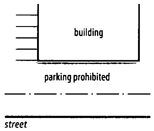
F.
Accessory Dwelling Units. Accessory dwelling units (ADUs), as defined in Section 45.031, are permitted by right.
(Ord. No. 24644, § 3, 7-21-2021; Ord. No. 24725, §§ 8, 9, 11-17-2021; Ord. No. 24825, §§ 2, 3, 5-18-2022; Ord. No. 25429, §§ 6, 7, 10-30-2024; Ord. No. 25656, § 11, 9-10-2025)
Section 20.090. - NCO, Neighborhood Character Overlay.
A.
General.
1.
Purpose and Intent. The Neighborhood Character Overlay (NCO) district establishes zoning regulations that are intended to promote compatibility of infill housing in established neighborhoods.
2.
Applicability.
a.
The regulations of this section apply to newly permitted detached houses, duplexes, and accessory buildings and any building alterations and site modifications for detached houses, duplexes, or accessory buildings that require a building permit within the boundaries of the NCO district. Any building, development, or structure for which a building permit was issued, or a complete building application has been accepted for processing prior to the effective date of the NCO district may be completed in conformance with the issued building permit and other applicable permits and conditions, even if such building, development, or structure does not comply with the provisions of the NCO district. If the building, development, or structure is not commenced and completed within the time allowed under the original building permit and any authorized permit extension, the building, development, or structure may be constructed, completed, and occupied only if it complies with the regulations of the NCO district.
b.
Complete applications for development plans, special exceptions, variances, or other zoning-related approvals that are pending approval on the date a property is supplementally zoned NCO must be reviewed wholly under the zoning regulations applicable to the property immediately preceding the date the property was supplementally zoned NCO. Building permits for construction and development approved under such zoning approvals may be issued in accordance with Section 20.090 A.2.c.
c.
The development administrator is authorized to issue building permits for construction or development approved before the date a property was supplementally zoned NCO and for developments pending approval under Section 20.090 A.2.b. even if such building, development, or structure does not fully comply with the NCO district regulations. If building is not commenced and completed within the time allowed under the building permit and any authorized permit extension, then the building, development, or structure may be constructed, completed, and occupied only if it complies with the NCO district regulations.
3.
Conflicting Regulations. All applicable regulations of the underlying base zoning district apply to property in the NCO district unless otherwise expressly stated in the NCO district regulations. For properties with approved development plans (PUD, CO, MPD, Optional Development Plan), the approved development plan and development standards apply.
4.
Nonconformities. Nonconformities that exist within the NCO district are governed by the regulations of Chapter 80.
B.
Lot and Building Regulations. In the Neighborhood Character Overlay district, the supplemental regulations of this section apply to detached houses and duplexes, and lots being used for detached houses and duplexes. General exceptions to these regulations and rules for measuring compliance can be found in Chapter 90.
1.
Maximum Building Height. The maximum allowable building height is thirty (30) feet.
2.
Maximum Building Width. The maximum allowable building width is forty (40) feet. For the purposes of the Neighborhood Character Overlay district, building width shall be measured from the exterior wall closest to the side setback to the exterior wall closest to the opposite side setback, parallel to the street setback. For corner lots, building width is measured parallel to the street setback not designated as the side street setback.
3.
Maximum Driveway Width. Driveways serving detached houses or duplexes may not exceed eighteen (18) feet in width within the right-of-way and within the street setback. Maximum width is applied to the composite of all driveways if multiple curb cuts are provided.
4.
Garage Setbacks. Street-facing garage doors must be set back at least thirty-six (36) feet and may not be located closer to the street than the front façade of the principal residential building. On corner lots, the side street setback may be reduced to twenty (20) feet.
C.
Accessory Building Regulations. In the Neighborhood Character Overlay, the supplemental regulations of this section apply to all detached accessory buildings.
(Ord. No. 24959, § 1, 11-16-2022; Ord. No. 25429, § 8, 10-30-2024; Ord. No. 25656, § 12, 9-10-2025)
Section 20.100. - NIO-2, Neighborhood Infill Overlay-2.
A.
General.
1.
Purpose and Intent. The Neighborhood Infill Overlay-2 (NIO-2) establishes zoning regulations that are intended to promote the development of alternative infill housing in established neighborhoods. The overlay allows for a variety of residential housing types in a manner that is compatible, in mass and scale, with the character of surrounding properties. The regulations are also intended to promote housing types that accommodate households of varying sizes and income levels and provide for a more efficient use of land for residential purposes.
2.
Applicability. Except as otherwise expressly stated, the Neighborhood Infill Overlay regulations of this section apply to RS-3, RS-4, RS-5, RD, RT, RM-0, RM-1, RM-2, RM-3, RMH, OL, OM, OMH, OH, CS, CG, CH, IL, IM, and IH zoning districts only within the boundaries of the Neighborhood Infill Overlay-2 districts to all new permitted uses and structures and all building alterations and site modifications that require a building permit.
3.
Nonconformities. Nonconformities that exist within the NIO-2 district are governed by the regulations of Chapter 80 except in residential zoning districts, a single detached house, duplex, or multi-unit house, where the particular residential building type is allowed by right or is allowed by special exception and a special exception has been granted, may be erected on a nonconforming lot without complying with the minimum lot area, minimum lot area per unit, minimum lot width, minimum street frontage or minimum open space per unit requirements of the subject zoning district, provided that at least fifty percent (50%) of the lot area remains as open space. All other lot and building regulations apply, except that detached houses, duplexes, or multi-unit houses may be erected on corner lots that are nonconforming with regard to lot width, subject to a reduced minimum street side building setback of five (5) feet. Garages that are accessed through a side yard abutting a street must be set back at least twenty (20) feet.
4.
Conflicting Regulations. All applicable regulations of the underlying base zoning district apply to property in the NIO-2 district unless otherwise expressly stated in the NIO-2 regulations. For properties with approved development plans (PUD, CO, MPD, Optional Development Plan), the approved development plan and development standards apply.
B.
Use Regulations - Residential, Household Living. Residential, household living principal uses are allowed in the NIO-2 district in accordance with Table 20-6.
1.
Permitted Uses. Residential, household living uses identified with a "P" symbol are allowed by right in the NIO-2 district within the particular base zoning district, subject to compliance with any supplemental regulations identified in Chapter 40 and all other applicable regulations of this zoning code.
2.
Special Exception Uses. Uses identified with an "S" may be allowed if reviewed and approved in accordance with the special exception procedures of Section 70.120.
3.
Prohibited Uses. Uses identified with an "-" are expressly prohibited. Uses that are not listed in the table and that cannot be reasonably interpreted (as stated in subsection 35.020-E) to fall within any defined use category are also prohibited.
Table 20-6: NIO-2 District Use Regulations for Household Living
C.
Residential Building Types for Household Living. In the NIO-2 district, within the particular base zoning district, household living uses must be located in the residential building types identified in Table 20-7. Descriptions of the residential building types and references to applicable regulations are found in Section 35.010.
Table 20-7: NIO-2 District Building Type Regulations for Household Living
1.
Table 20-7 Notes. The following notes refer to the bracketed numbers (e.g.," [1]") in (Table 20-7):
[1]
Apartment/condo is limited to no more than 4 dwelling units on a single lot.
[2]
Manufactured housing units manufactured in 2016 or later are permitted by right if they are skirted with masonry, have a street-facing entrance, and are attached to a permanent foundation. All other manufactured housing units require a special exception approved in accordance with the procedures of Section 70.120.
D.
Lot and Building Regulations. In the NIO-2 district, the lot and building regulations of Table 20-8 apply in the RS-3, RS-4, RS-5, RD, RT, RM-0, RM-1, RM-2, RM-3, RHM, OL, OM, OMH, OH, CS, CG, CH, IL, IM, and IH base zoning districts to Detached House, Manufactured Housing Unit, Duplex, Townhouse, Cottage House Development, Multi-unit House and Apartment/Condo building types. General exceptions to these regulations and rules for measuring compliance can be found in Chapter 90. Regulations governing accessory uses and structures can be found in Chapter 45.
Table 20-8: NIO-2 District Lot and Building Regulations
Table 20-8 Notes:
The following notes refer to the bracketed numbers (e.g.," [1]") in (Table 20-8):
[1]
Minimum street frontage requirements apply to townhouse developments, not to individual townhouse units. Cottage house developments require minimum street frontage of 50 feet.
[2]
Minimum setback for street-facing garage doors is 20 feet.
[3]
No side setback is required for interior units in townhouse developments. Side setback applies to end units.
D.
Home Occupations. In the NIO-2 district, both Type 1 and Type 2 home occupations are permitted as a matter of right.
E.
Modification to Lot and building regulations for the IL Zoning Districts.
1.
In the NIO-2 district, the building setback from AG, AG-R and R districts is reduced from seventy-five (75) feet to ten (10) feet in the IL base zoning district for all non-residential uses.
F.
Reserved.
G.
Accessory Dwelling Units. Accessory dwelling units (ADUs), as defined in Section 45.031, are permitted by right.
(Ord. No. 25087, § 1, 7-19-2023; Ord. No. 25330, § 3, 6-5-2024; Ord. No. 25429, §§ 9, 10, 10-30-2024; Ord. No. 25656, § 13, 9-10-2025)
Section 20.110. - NCO-2, Neighborhood Character Overlay 2.
A.
General.
1.
Purpose and Intent. The Neighborhood Character Overlay 2 (NCO-2) district establishes regulations that are intended to promote the compatibility of infill housing in established neighborhoods.
2.
Applicability. The regulations of this section apply to newly permitted residential buildings and additions that require a building permit within the boundaries of the NCO-2 district. Any building, development, or structure for which a building permit was issued, or a complete building application has been accepted for processing prior to the effective date of the NCO-2 district may be completed in conformance with the issued building permit and other applicable permits and conditions, even if such building, development, or structure does not comply with the provisions of the NCO-2 district. If the building, development, or structure is not commenced and completed within the time allowed under the original building permit and any authorized permit extension, the building, development, or structure may be constructed, completed, and occupied only if it complies with the regulations of the NCO-2 district.
3.
Conflicting Regulations. All applicable regulations of the underlying base zoning district apply to property in the NCO-2 district unless otherwise expressly stated in the NCO-2 district regulations. For properties with approved development plans, the approved development plan and development standards apply.
4.
Nonconformities. Nonconformities that exist within the NCO-2 district are governed by the regulations of Chapter 80.
B.
Lot and Building Regulations. General exceptions to these regulations and rules for measuring compliance may be found in Chapter 90.
1.
Maximum Building Height. The maximum allowable building height is limited to 30 feet and no more than two stories.
2.
Maximum Building Width. The maximum allowable building width is 40 feet. For the purposes of this section, building width shall be measured from the exterior wall closest to the side setback to the exterior wall closest to the opposite side setback, parallel to the street setback. For corner lots, building width is measured parallel to the street setback not designated as the side street setback.
3.
Maximum Driveway Width. Driveways serving residential buildings may not exceed twelve (12) feet in width within the right-of-way and within the street setback, including the combined width of all driveways.
4.
Garage Setbacks. Street-facing garage doors must be set back at least eighteen (18) feet behind the front façade of the principal residential building. On corner lots, the side street setback is reduced to twenty (20) feet.
5.
Minimum Roof Pitch. Buildings, excluding porches, must have a minimum roof pitch of twelve (12) inches of vertical lift per every twelve (12) inches of horizontal distance, unless a lower pitch is approved in accordance with the special exception procedures of Section 70.120.
6.
Front Porch or Stoop Requirement. Principal buildings in the NCO-2 district must have a porch or stoop located on the front street-facing side of the building. For the purposes of this section, a front porch is defined as a covered structure that extends from a building's entrance a minimum of five (5) feet, and a stoop is defined as a raised, flat landing in front of a house door, with steps leading up to it.
7.
Required Building Orientation. The primary building entrances must be entered through the required porch or stoop. In the case of principal buildings on corner lots, the primary entrance must be located on the street for which they have the least amount of frontage.
8.
Building Setbacks. At least fifty (50) percent of the front street-facing building façade must be located within thirty-five (35) feet of the front property line. No part of the building may be located closer than twenty-five (25) feet from the front property line.
C.
Accessory Building Regulations. In the Neighborhood Character Overlay 2, the supplemental regulations of this section apply to all detached accessory buildings, including accessory dwelling units (ADUs) established in conjunction with household living uses.
1.
Accessory Dwelling Units. Accessory Dwelling Units (ADUs), as defined in Section 45.031, are permitted by right.
2.
Accessory Building Coverage of Rear Setback. The maximum allowable coverage of the rear setback by accessory buildings is fifty (50) percent.
(Ord. No. 25621, § 1, 7-16-2025)