
Tulsa City Zoning Code
CHAPTER 25
- SPECIAL DISTRICTS
Section 25.010.- General.
A.
Purpose. Like overlay zoning districts, special purpose zoning districts are tools for dealing with unique neighborhoods or settings or accomplishing special planning and zoning goals. Unlike overlay districts, however, special districts are base zoning classifications; they do not "over-lay" other base zoning districts.
B.
Establishment. Except as otherwise expressly stated, special districts may be established, amended or removed only in accordance with the zoning map amendment procedures of Section 70.030.
Section 25.020. - AG, Agricultural District and AG-R, Agricultural-Residential District.
A.
Purposes.
1.
The AG, Agricultural district is primarily intended to accommodate agricultural, mining or mineral processing uses in rural areas. The district also allows very low-density residential and other uses and serves as a holding zone pending an orderly transition to more urban development that can be efficiently served by public facilities and services.
2.
The AG-R, Agricultural-Residential district is primarily intended for areas of the city that are generally located on the outer edge of urbanized development. The district is designed to acknowledge the desire for lower-density residential development with larger lot sizes. While land use regulations and lot and building standards are primarily geared towards residential uses, some agricultural uses could also be permitted.
B.
Use regulations.
1.
Uses are allowed in AG and AG-R districts in accordance with Table 25-1. These uses are described in Chapter 35. Uses identified with a "P" are permitted as-of-right. Uses identified with an "S" may be allowed only if reviewed and approved in accordance with the special exception procedures of Section 70.120. All allowed uses are subject to compliance with all other applicable regulations of this zoning code.
2.
Uses identified with an "-" are expressly prohibited. Uses that are not listed in the table and that cannot be reasonably interpreted (as stated in Subsection 35.020E.) to fall within any defined use category are also prohibited.
Table 25-1: AG and AG-R District Use Regulations
3.
Table Notes:
[1]
See Title 2, Chapter 2 of the Tulsa Revised Ordinances.
[2]
A Farm, Market- or Community-supported, may only be allowed in an AG-R district where the land area of a single parcel is greater than 2 acres.
[3]
Only family child care homes that were operating as a principal-use family child care home under a valid license issued from the State of Oklahoma on or before November 15, 2023, and have been issued a certificate of occupancy for a family child care home by December 31, 2025, may be considered established for the purposes of this provision. Said license may be for a Family Child Care Home or Large Family Child Care Home as permitted by the State of Oklahoma, provided that the child care home has a licensed capacity of no greater than 12 children. At the time the license expires, is revoked by the State of Oklahoma, is transferred to another entity, or the child care home ceases operation for longer than 6 months, the property will lose its status as established and the family child care home will require a Special Exception.
C.
Residential building types. Residential uses allowed in AG and AG-R districts must be located in residential buildings. Descriptions of the residential building types and references to applicable regulations are found in Section 35.010. The following residential building types are allowed in AG and AG-R districts:
Table 25-1.5: AG District Building Type Regulations for Household Living
D.
Lot and Building Regulations. The lot and building regulations of Table 25-2 apply to all principal uses and structures in AG and AG-R districts, except as otherwise expressly stated in this zoning code. General exceptions to lot and building regulations and rules for measuring compliance can be found in Chapter 90. Additional regulations governing accessory uses and structures can be found in Chapter 45.
Table 25-2: AG District Lot and Building Regulations
(Ord. No. 24328, § 4, 3-11-2020; Ord. No. 24725, §§ 10, 11, 11-17-2021; Ord. No. 25192, § 4, 12-6-2023; Ord. No. 25429, §§ 11, 12, 10-30-2024; Ord. No. 25604, § 4, 6-18-2025; Ord. No. 25656, § 14, 9-10-2025)
Section 25.030. - PK, Parking district.
A.
Purpose. The PK, Parking district is primarily intended to accommodate off-street parking areas bordering nonresidential zoning districts, while protecting nearby residential areas from adverse impacts associated with spillover parking into residential neighborhoods.
B.
Use regulations. Parking lots, including parking structures, are the only uses permitted in the PK district. Such parking lots may be used for off-site accessory parking or for non-accessory parking.
C.
Lot and building regulations.
1.
Table of regulations. The lot and building regulations of Table 25-3 apply to all principal uses and structures in PK districts, except as otherwise expressly stated in this zoning code. General exceptions to lot and building regulations and rules for measuring compliance can be found in Chapter 90. Additional regulations governing accessory uses and structures can be found in Chapter 45.
Table 25-3: PK District Lot and Building Regulations
2.
Table notes. The following notes refer to the bracketed numbers (e.g.," [1]") in Table 25-3:
[1]
No part of any parking space, drive aisle or fence or wall that is over 4 feet in height may be located closer to a minor street right-of-way line than any residential building occupying an abutting lot with frontage on the same minor street as the parking lot (see Figure 25-1 and Figure 25-2).
Figure 25-1: Parking Setback from Street on Lots Abutting Residential Buildings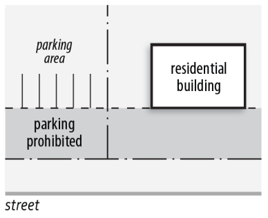
Figure 25-2: Fence Setback from Street Abutting Residential Building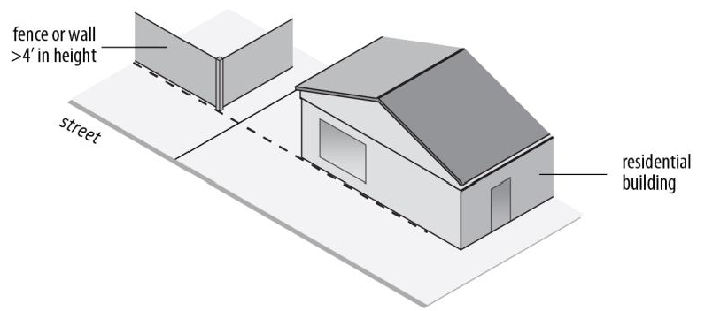
[2]
When a PK district abuts an R or AG-R district, a masonry screening wall must be provided along the common lot line in accordance with the F1 screening fence or wall standards of Subsection 65.070C.
[3]
Buildings in the PK district may not exceed 35 feet in height, unless reviewed and approved in accordance with the special exception procedures of Section 70.120.
Section 25.040. - CO, Corridor district.
A.
Purpose. The CO, Corridor district is established to allow and encourage high-intensity, multi-use development, in compliance with an approved development plan, in order to:
1.
Accommodate intensive uses and development near high-capacity thoroughfares;
2.
Allow for a wide range of lifestyles and housing types close to employment, recreational, shopping, and cultural facilities;
3.
Maximize the interrelationship between land use and transportation and in particular encourage development patterns compatible with the evolution of transit;
4.
Provide direct, safe and convenient non-motorized travel routes within the boundaries of the development site, as well as connections to abutting properties;
5.
Maximize use of higher capacity segments within the city's overall transportation network;
6.
Accommodate a more productive use of land consistent with the public objectives and standards of accessibility and land use compatibility; and
7.
Maintain the traffic carrying capacity of the city's transportation network by encouraging access from internal streets or private drives.
B.
Use regulations.
1.
Uses identified with a "P*" in Table 25-4 may be approved in CO districts at the time of development plan approval. Only uses approved through the development plan approval process of Section 70.040 are allowed. Allowed uses are subject to compliance with all other applicable regulations of this zoning code.
2.
Uses identified with an "-" are expressly prohibited. Uses that are not listed in the table and that cannot be reasonably interpreted (as stated in Subsection 35.020E.) to fall within any defined use category are also prohibited.
Table 25-4: CO District Use Regulations
[1]
Allowed only when located within freeway sign corridors. See Chapter 60 for other supplemental regulations that apply to off-premise outdoor advertising signs.
C.
Residential building types. Residential uses allowed in CO districts must be located in residential buildings. Descriptions of the residential building types and references to applicable regulations are found in Section 35.010. The following residential building types are allowed in CO districts.
Table 25-4.5: CO District Building Type Regulations for Household Living
D.
Lot and building regulations The lot and building regulations that apply within a CO zoning district must be established at the time of development plan approval by the City Council.
E.
Special procedures applicable to Corridor (CO) district rezonings and developments.
1.
Overview of required approval process.
a.
A property owner request for rezoning to the CO zoning district requires review and approval of a zoning map amendment (see Section 70.030) and a development plan (see Section 70.040) for the subject property.
b.
The planning commission is authorized to recommend and the City Council is authorized to approve modifications and adjustments to otherwise applicable parking, sign, landscaping, screening and outdoor lighting regulations concurrently with development plan approval.
c.
After approval of the zoning map amendment and development plan, site plan review and approval is required in accordance with the procedures of Section 70.050.
d.
No building permit may be issued and no building or development may occur in a CO zoning district until a zoning clearance permit has been issued in accordance with Section 70.080.
2.
Supplemental review and approval criteria. In making recommendations and decisions on CO district zoning map amendments and development plans, review and decision-making bodies must consider the zoning map amendment criteria of Subsection 70.030H. and the following factors:
a.
Whether the proposed corridor development will be compatible with the existing and expected development of surrounding areas;
b.
Whether the proposed corridor development is a unified treatment of the development possibilities of the project site;
c.
Whether provision has been made for proper access, circulation, and functional relationships of uses; and
d.
Whether the proposed corridor development is consistent with the stated purposes of this zoning code.
3.
Restrictive covenants. No building permit may be issued, and no building or development may occur in a CO zoning district until covenants necessary to reasonably ensure continued compliance with the approved development plan are recorded in the County Clerk's office. Such covenants may be established in a subdivision plat or in a separately recorded legal instrument. In order that the public interest may be protected, the City of Tulsa must be made beneficiary of the covenants pertaining to such matters as location of uses, height of structures, setbacks, screening, and access. Such covenants must provide that the City of Tulsa may enforce compliance of the covenants, and further provide that amendment of the covenants requires planning commission approval and the filing of record of a written amendment to covenants, endorsed by the planning commission.
4.
Issuance of building permits. Building permits may be issued only after a zoning clearance permit has been issued in accordance with Section 70.080 and covenants have been recorded in accordance with Subsection 25.040E.3. Any permits issued must be in accordance with the approved development plan.
5.
Amendments. The planning commission is authorized to approve minor amendments to an approved development plan as long as substantial compliance is maintained with the approved development plan. Major amendments must be processed as new development plans. See Subsection 70.040I.
6.
Abandonment of approved plans. Abandonment of an approved development plan requires review and recommendation by the planning commission and approval by the City Council. Upon final action by the city council authorizing abandonment of the development plan, no building permits may be issued until a subsequent development plan has been approved and a zoning clearance permit has been issued or until the property has been rezoned to another zoning district and permits sought in accordance with the regulations applicable to the subject district.
(Ord. No. 24725, § 12, 11-17-2021; Ord. No. 25192, § 5, 12-6-2023; Ord. No. 25604, § 5, 6-18-2025)
Section 25.050. - SR, Scientific Research district.
A.
Purpose. The SR, Scientific Research district is intended to accommodate and promote modern, scientific research facilities and institutions.
B.
Use regulations.
1.
Principal uses are allowed in SR districts in accordance with Table 25-5. These uses are described in Chapter 35. Uses identified with a "P" are permitted as-of-right. Uses identified with an "S" may be allowed if reviewed and approved in accordance with the special exception procedures of Section 70.120. All allowed uses are subject to compliance with all other applicable regulations of this zoning code.
2.
Uses identified with an "-" are expressly prohibited. Uses that are not listed in the table and that cannot be reasonably interpreted (as stated in Subsection 35.020E.) to fall within any defined use category are also prohibited.
Table 25-5: SR District Use Regulations
C.
Lot and building regulations. The lot and building regulations of Table 25-6 apply to all principal uses and structures in SR districts, except as otherwise expressly stated in this zoning code. General exceptions to lot and building regulations and rules for measuring compliance can be found in Chapter 90. Additional regulations governing accessory uses and structures can be found in Chapter 45.
Table 25-6: SR District Lot and Building Regulations
[1]
When abutting RE- or RS-zoned lot, two (2) feet of additional building setback required for each one foot of building height above thirty-five (35) feet.
[2]
Minimum building setback abutting freeway right-of-way that is zoned AG, AG-R, R or O is ten (10) feet.
D.
Supplemental Regulations In the SR district, all research service uses must be conducted within a completely enclosed building.
(Ord. No. 24725, § 13, 11-17-2021; Ord. No. 25192, § 6, 12-6-2023; Ord. No. 25604, § 6, 6-18-2025)
Section 25.060. - IMX, Institutional Mixed-Use.
A.
General.
1.
Purposes. The Institutional Mixed-Use (IMX) district is designed to:
a.
Achieve the economic objectives of the comprehensive plan by encouraging sustainable growth of regional job centers anchored by institutions.
b.
Meet the need for medical and educational services in the metropolitan area and trade area.
c.
Provide an environment conducive to the development and conservation of medical and educational institutions.
d.
Permit the establishment of uses which are customarily located in proximity to such institutions.
e.
Accommodate a mix of uses and encourage a compatible relationship with adjoining land uses and thoroughfares by:
(1)
Establishing lot and building regulations, including transitional height regulations, which help to ensure compatibility among areas with different uses and development intensities;
(2)
Requiring off-street parking and loading facilities to mitigate vehicular impacts in surrounding residential areas;
(3)
Controlling the number, size, height, sign area, location and types of signs; and
(4)
Preserving, enhancing and creating open space.
2.
Zoning criteria.
a.
Properties proposed for IMX zoning must include one or more hospitals, colleges, or universities.
b.
The minimum contiguous land area required for an IMX district is five (5) acres, provided that properties of less than five (5) acres in area that are contiguous with existing IMX-zoned areas or that are separated from existing IMX-zoned areas only by a non-arterial street, alley or railroad right-of-way, may be approved for IMX zoning.
B.
Use regulations.
1.
Principal uses are allowed in IMX districts in accordance with Table 25-7. These uses are described in Chapter 35. Uses identified with a "P" are permitted as-of-right. Uses identified with an "S" may be allowed only if reviewed and approved in accordance with the special exception procedures of Section 70.120. All allowed uses are subject to compliance with all other applicable regulations of this zoning code.
2.
Uses identified with an "-" are expressly prohibited. Uses that are not listed in the table and that cannot be reasonably interpreted (as stated in Subsection 35.020E.) to fall within any defined use category are also prohibited.
Table 25-7: IMX District Use Regulations
3.
Table notes. The following notes refer to the bracketed numbers (e.g.," [1]") in Table 25-7:
[1]
Requires special exception approval if alcoholic beverages are sold or served and the subject lot is located within one hundred fifty (150) feet of any residential zoning district other than R-zoned street right-of-way.
[2]
Vehicular and pedestrian circulation must be reviewed and approved by traffic engineering, including the location of ingress and egress points.
[3]
No surface parking lot, whether a principal use or accessory use, is permitted within one hundred (100) feet of any HP district.
[4]
Package stores require special exception approval, and vehicular and pedestrian circulation must be reviewed and approved by traffic engineering, including the location of ingress and egress points.
[5]
When located the Healthy Neighborhoods Overlay (HNO) district the use is regulated as stated in Subsection 20.060D.
4.
Accessory uses.
a.
Accessory uses are not regulated by Table 25-7. Customary accessory uses are allowed in conjunction with principal uses permitted by right or by special exception, subject to compliance with all applicable accessory use regulations of Chapter 45. The following are expressly allowed as accessory uses in the IMX district:
(1)
Heliport.
(2)
Loading dock and storage facilities.
(3)
Repair and service facilities, including vehicle repair.
(4)
Laundry facilities.
(5)
Parking, provided that no surface parking is permitted within one hundred (100) feet of HP district.
(6)
Physical plant.
(7)
Disaster shelters.
(8)
Antennas and supporting structures.
(9)
Signs, in accordance with Chapter 60.
b.
All accessory buildings must comply with minimum building setback requirements.
c.
An accessory building erected as an integral part of the principal building must be made structurally a part of the principal building, have a common wall with the principal building, and comply with the requirements applicable to the principal building.
C.
Residential building types. Residential uses allowed in IMX districts must be located in residential buildings. Descriptions of the residential building types and references to applicable regulations are found in Section 35.010. The following residential building types are allowed in IMX districts:
Table 25-7.5: IMX District Building Type Regulations for Household Living
D.
Lot and building regulations.
1.
Table of regulations. The lot and building regulations of Table 25-8 apply to all new construction and building additions in IMX districts. General exceptions to lot and building regulations and rules for measuring compliance can be found in Chapter 90. Existing buildings are exempt from compliance with build-to-zone (BTZ) and transparency regulations.
Table 25-8: IMX District Lot and Building Regulations
2.
Table notes. The following notes refer to the bracketed numbers (e.g.," [1]") in Table 25-8:
[1]
A minimum side setback of ten (10) feet is required on lots abutting an R district, an HP district, or a lot occupied by a detached house, duplex or townhouse without an intervening right-of-way. Required side setbacks may not be used for parking, paving, loading, servicing or any other activity, and must comply with the L1 landscape yard requirements of Subsection 25.060H.1.
[2]
A minimum rear setback of twenty (20) feet is required on lots abutting an R district, an HP district, or a lot occupied by a detached house, duplex or townhouse without an intervening right-of-way. Required rear setbacks may not be used for parking, paving, loading, servicing or any other activity, and must comply with the L1 landscape yard requirements of Subection 25.060H.1.
[3]
A minimum ten-foot deep buffer yard that complies with the L1 landscape yard requirements of Subsection 25.060H.1. must be provided to separate parking from the sidewalk, except no buffer yard is required where the ground-floor level of a parking garage or structure is masked by a liner building.
[4]
In all cases, a minimum setback distance of twelve (12) feet is required between the edge of curb and the face of the building.
[5]
A functional building entrance door is required on each street-facing façade, and each dwelling unit on the ground-floor level shall have a functional building entrance facing the street. The length of street-facing facade without an intervening entrance may not exceed one hundred fifty (150) feet. An angled or curved entrance may be provided at either corner of a building along the street to meet the street-facing entrance requirements along both streets. On corner lots, the street-facing entrance requirement does not apply along the side street.
[6]
In the IMX district, the transparency of a ground floor facade is measured between three (3) and eight (8) feet above the adjacent curb.
E.
Height regulations. No maximum height limits apply in the IMX district except in the following cases:
1.
When an IMX district abuts an HP district with an intervening right-of-way that is not an alley, a maximum height limit of thirty-five (35) feet applies within one hundred (100) feet of the right-of-way centerline.
2.
When an IMX district abuts an R or AG-R district with an intervening right-of-way that is not an alley, a maximum height limit of forty-eight (48) feet applies within one hundred (100) feet of the right-of-way centerline.
3.
When an IMX district abuts an R, AG-R, or an HP district with an intervening alley, a maximum height limit of twenty-four (24) feet applies within forty (40) feet of the alley centerline and a maximum height limit of forty-eight (48) feet applies at a distance between forty (40) feet and ninety (90) feet of the alley centerline.
4.
When an IMX district abuts an R, AG-R, or an HP district without an intervening right-of-way, a maximum height limit of twenty-four (24) feet applies within fifty (50) feet of the lot boundary and a maximum height limit of forty-eight (48) feet applies at a distance between fifty (50) and one hundred (100) feet of the lot boundary.
5.
A maximum height limit of ninety-six (96) feet applies for a distance of one hundred (100) feet from the forty-eight-foot feet maximum height limit zone where the IMX district abuts an HP district.
F.
Structured parking facilities. Parking structures must be designed to visually conceal parking at ground-floor level and the second floor level through the use of architectural detailing or liner buildings.
G.
Loading areas and dumpsters.
1.
Loading dock entrances must be screened from public view at ground level by masonry walls.
2.
Dumpsters are subject to the regulations of Section 45.050, provided that dumpsters in the IMX district must be screened from public view at ground level by masonry walls.
H.
Landscaping and screening. Landscaping and screening in the IMX district must meet or exceed the minimum regulations of this subsection and the minimum regulations of Section 65.050, Section 65.090 and Section 65.100. The other landscaping and screening regulations of Chapter 65 do not apply in the IMX district.
1.
L1 landscape transition yards.
a.
When required. L1 landscape transition yards with a minimum depth of ten (10) feet are required in all of the following cases:
(1)
When development occurs on a lot abutting an R, AG-R, or HP district, or a lot occupied by a detached house, duplex or townhouse without an intervening right-of-way;
(2)
When off-street parking lots or structures are located adjacent to sidewalks or public rights-of-way, except that L1 landscape yards are not required when the ground-floor level of a parking garage or structure is masked by a liner building.
b.
Trees. Trees must be provided in L1 landscape transition yards as follows:
(1)
At least one medium or large tree must be provided per twenty-five (25) linear feet of landscape transition yard.
(2)
If medium or large trees are not appropriate due to overhead utilities or other obstructions one small tree must be provided per twenty (20) linear feet of landscape yard.
(3)
Trees must generally be evenly spaced.
(4)
Medium and large trees must be a minimum of two and one-half (2.5) inches in caliper size and at least twelve (12) feet in height at time of planting. Small trees must be a minimum of two (2) inches in caliper size and at least eight (8) feet in height at time of planting.
c.
Understory plantings meeting the following requirements must be provided in all L1 landscape transition yards:
(1)
Ground covers or shrubs must be provided at a size and density in order to protect tree roots and to prevent erosion within a three-year growth cycle.
(2)
Sod is not permitted in required L1 landscape transition yards.
(3)
Where used to meet the landscape requirement, shrubs must be maintained at a minimum height of three (3) feet and a maximum height of eight (8) feet with no more than fifty (50) percent opacity.
d.
Screening must be provided within L1 landscape transition yards as follows:
(1)
Opaque walls or fences a minimum height of six (6) feet must be provided if the L1 landscape transition yard is in a side or rear setback and must be maintained in good condition. Screening is not required if the subject lot is occupied by a detached house, duplex or townhouse.
(2)
Opaque walls with a minimum height of thirty-six (36) inches must be provided within ten (10) feet of a surface parking lot edge where surface parking is located within one hundred (100) feet of any IMX district boundary except when a building is located between the IMX district boundary and the surface parking lot. Walls must be maintained in good condition.
2.
L2 street tree yards.
a.
When required. L2 street tree yards with a minimum depth of ten (10) feet are required between the planned right-of-way and the closest edge of the build-to-zone within the lot, extending the full width of the lot.
b.
Trees. Trees must be provided in L2 street tree yards as follows:
(1)
At least one medium or large tree must be provided per twenty-five (25) linear feet of street frontage.
(2)
If medium or large trees are not appropriate due to overhead utilities or other obstructions one small tree must be provided per twenty (20) linear feet of street frontage.
(3)
Trees must generally be evenly spaced.
(4)
Medium and large trees must be a minimum of two and one-half (2.5) inches in caliper size and at least twelve (12) feet in height at time of planting. Small trees must be a minimum of two (2) inches in caliper size and at least eight (8) feet in height at time of planting.
I.
Walls and fences. Except as otherwise provided in this zoning code, fences or walls within a street tree yard may not exceed thirty-six (36) inches in height. Fences or walls in other locations may not exceed eight (8) feet in height.
J.
Mechanical equipment.
1.
Mechanical equipment is not permitted between the building and the street.
2.
An opaque wall or fence exceeding the height of the equipment is required if the equipment is visible from a public street or from adjacent properties at the level where such equipment is located.
3.
Rain barrels, cisterns, and similar equipment designed as part of the building do not require screening.
4.
Chiller plants and similar utility structures must be screened from public rights-of-way and abutting R- or AG-R-zoned lots, HP districts, and lots occupied by a detached houses, duplexes or townhouses. Required screening must consist of a masonry wall that is at least six (6) feet in height. Trees must also be provided as required in L1 landscape transition yards (see Subsection 25.060H.1.b.).
(Ord. No. 24725, § 14, 11-17-2021; Ord. No. 25192, § 7, 12-6-2023; Ord. No. 25604, § 7, 6-18-2025)
Section 25.070. - MPD, Master Planned Development district.
A.
Purpose and intent. The MPD, Master Planned Development district is established to accommodate development that would be difficult or impossible to carry out under otherwise applicable zoning regulations. Different types of MPDs will promote different planning goals. In general, however, all MPDs are intended to result in development that is consistent with the city's adopted plans and that provides greater public benefits than could be achieved using conventional zoning regulations. MPDs are also generally intended to promote one or more of the following:
1.
Variety in housing types and sizes to accommodate households of all ages, sizes, incomes and lifestyle choices;
2.
Compact, mixed-use development patterns where residential, commercial, employment, civic, and open space areas are located in close proximity to one another;
3.
A transportation network designed to accommodate safe and efficient motorized and non-motorized travel;
4.
Direct, safe and convenient non-motorized travel routes within the boundaries of the development site, as well as connections to abutting properties;
5.
Buildings and other improvements that by their arrangement, massing, design, character and site design elements establish a quality, livable environment;
6.
Sustainable development practices;
7.
Incorporation of open space amenities and natural resource features into the development design;
8.
Low-impact development (LID) and best management practices for managing stormwater; and
9.
Flexibility and creativity in responding to changing social, economic and market conditions.
B.
Initiation of amendment. Applications to establish an MPD district or expand the boundaries of an existing MPD district may be initiated only by the owner of the subject property.
C.
Statement of intent. Each MPD application must include a written explanation describing how the proposed development meets the purpose and intent described in Subsection 25.070A. and the supplemental review and approval criteria of Subsection 25.070D.2.
D.
MPD approval procedures.
1.
Overview of required approval process.
a.
A property owner request for rezoning to the MPD zoning district requires review and approval of a zoning map amendment (see Section 70.030), which is processed concurrently with a development plan (see Section 70.040).
b.
After approval of the zoning map amendment and development plan, site plan review and approval is required in accordance with the procedures of Section 70.050.
c.
No building permit may be issued and no building or development may occur in a MPD zoning district until a zoning clearance permit has been issued in accordance with Section 70.080.
2.
Supplemental review and approval criteria. In making recommendations and decisions on MPD district zoning map amendments, review and decision-making bodies must consider the zoning map amendment criteria of Subsection 70.030H. and the following factors:
a.
Whether the proposed master planned development is consistent with the comprehensive plan and any other adopted plans for the subject area;
b.
Whether the development plan complies with the MPD district provisions of Section 25.070;
c.
Whether the development will result in public benefits that are equal to or greater than those that would have resulted from development under conventional zoning (non-MPD) regulations; and
d.
Whether appropriate terms and conditions have been imposed on the approval to protect the interests of surrounding property owners and residents, existing and future residents of the MPD and the general public.
3.
Restrictive covenants. No building permit may be issued, and no building or development may occur in an MPD district until covenants necessary to reasonably ensure continued compliance with the approved development plan are recorded in the County Clerk's office. Such covenants may be established in a subdivision plat or in a separately recorded legal instrument. In order that the public interest may be protected, the City of Tulsa must be made beneficiary of the covenants pertaining to such matters as location of uses, height of structure, setbacks, screening, and access. Such covenants must provide that the City of Tulsa may enforce compliance of the covenants, and further provide that amendment of the covenants requires planning commission approval and the filing of record of a written amendment to covenants, endorsed by the planning commission.
4.
Issuance of building permits. Building permits may be issued only after a zoning clearance permit has been issued in accordance with Section 70.080 and covenants have been recorded in accordance with Subsection 25.070D.3. Any permits issued must be in accordance with the approved development plan.
E.
Abandonment. Abandonment of an approved MPD requires that the property be rezoned to another zoning district in accordance with the zoning map amendment procedures of Section 70.030 or that a new MPD be approved following the procedures of Subsection 25.070D.
F.
Use regulations and lot and building standards The use regulations and lot and building standards that apply within an MPD zoning district must be established at the time of development plan approval by the City Council.
G.
Other development standards. Unless otherwise expressly provided in the approved development plan, properties within the MPD district are subject to all other applicable provisions of this zoning code and the subdivision and development regulations. The MPD district is expressly intended to accommodate the use of alternative standards for streets and other public improvements based on the approved development plans. The development plan must specify the deviations proposed from otherwise applicable public improvement standards if deviations from otherwise applicable standards are proposed.