
Wake County Unincorporated
City Zoning Code
City Zoning Code
ARTICLE 11
- Environmental Standards
11-10 - Applicability of Neuse Riparian Buffer Protection Rules.
The riparian buffer protection rules of 15 A NCAC 2B.0233 (Neuse River Basin: Nutrient Sensitive Waters Management Strategy: Protection and Maintenance of Existing Riparian Buffers) apply to all lands within the Neuse River and Cape Fear River basins. The County administers the Jordan Lake Buffer Rules on behalf of the State of NC per 15A NCAC 02B .0267 JORDAN WATER SUPPLY NUTRIENT STRATEGY: PROTECTION OF EXISTING RIPARIAN BUFFERS.
[Amended on 10/20/2025 by OA-05-25]
11-20 - Purpose.
Water supply watershed buffers provide strips of natural vegetation that remove pollutants from stormwater runoff before they reach a water supply source or a watercourse that drains to a water supply source. They do so by allowing infiltration of runoff and filtration of pollutants through the ground and soil, slowing runoff flow to allow settling and deposition of pollutants, and providing vegetation that absorbs pollutants through root systems. The provision of vegetated, undisturbed buffers within water supply watersheds, therefore, is an important and effective means of maintaining the quality of public water supply sources and protecting those sources from potential polluting activities associated with development.
11-21 - Buffer Location and Width.
Water supply watershed buffers and building setbacks from such buffers must be provided in accordance with the following requirements.
11-21-1
General.
(A)
The United States Geologic Survey (USGS) 1:24,000 scale (7.5 minute) quadrangle topographic maps (also referred to as the historic quadrangle topographic maps) or the most recent paper-bound version of the soil survey map prepared by the Natural Resources Conservation Service of the United States Department of Agriculture (USDA) shall be used to identify surface water subject to the requirements of this section. If any surface water is depicted differently on the above referenced maps, the most restrictive depiction shall apply except as otherwise provided in paragraph 11-21-1(B).
(B)
A landowner or other affected party who believes that one or more maps inaccurately depict or omit existing surface water(s), based on site-specific evidence, may submit for review and approval an on-site determination prepared by a qualified professional. The professional must have successfully completed the North Carolina Division of Water Resources' Surface Water Identification Training Certification course, its successor, or other equivalent training curriculum approved by the State for the purposes of determining stream classifications. All on-site determinations shall be subject to review and approval by the County and shall be valid for five years from the date of the determination unless a shorter time is specified otherwise therein.
(C)
Buffers described in Sec. 11-21-6 and Sec. 11-21-3 were previously identified and platted as "drainageway buffers." Because they serve the same function and are subject to the same limitations as water supply watershed buffers, they have been re-designated as "water supply watershed buffers."
(D)
Some streams may require both water supply watershed buffers and Neuse River riparian buffers.
(E)
All limits of disturbance within watershed buffers apply to each side of the water body.
11-21-2
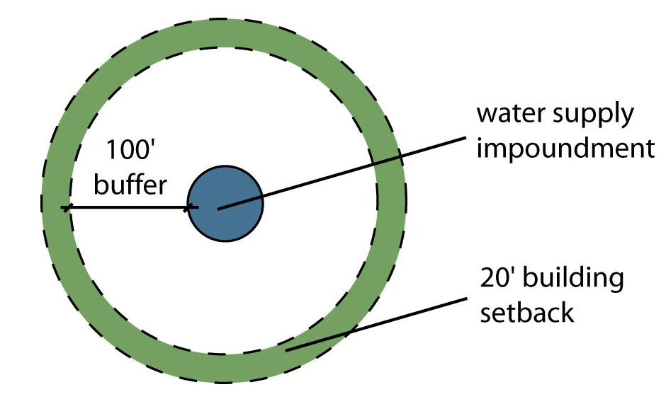
Water Supply Impoundments, 25 Acres or More.
(A)
A water supply watershed buffer with a minimum width of 100 feet must be provided around all water supply impoundments with a drainage area of 25 acres or more that are located inside the water supply watershed draining into the water supply water impoundment.
(B)
The buffer width is to be measured perpendicular to the shoreline starting at the flood pool elevation of the water supply impoundment.
(C)
Buildings must be setback at least 20 feet from the outer boundary of the required buffer area.
11-21-3
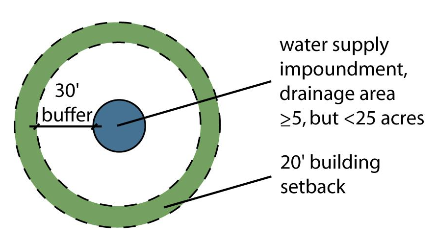
Water Supply Impoundments, At Least Five But Less Than 25 Acres.
(A)
A water supply watershed buffer with a minimum width of 30 feet must be provided around all water impoundments with a drainage area of at least five acres, but less than 25 acres, located inside the watershed draining into the water supply impoundment.
(B)
Required buffers are to be measured perpendicular to the shoreline starting at the normal pool elevation of the water impoundment.
(C)
Buildings must be setback at least 20 feet from the outer boundary of the required buffer area.
11-21-4
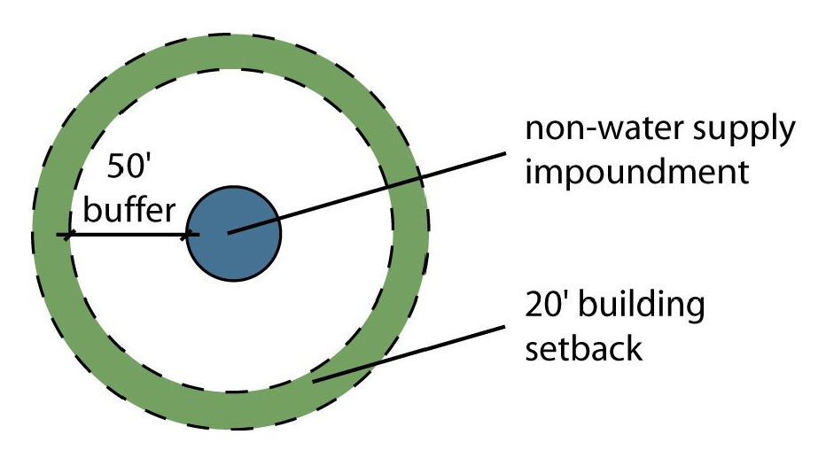
Non-Water Supply Impoundments, 25 Acres or More.
(A)
A water supply watershed buffer with a minimum width of 50 feet must be provided around all non-water supply impoundments with a drainage area of 25 acres or more that are located inside the watershed draining into the non-water supply impoundment.
(B)
The buffer width is to be measured perpendicular to the shoreline starting at the normal pool elevation of the non-water supply impoundment.
(C)
Buildings must be setback at least 20 feet from the outer boundary of the required buffer area.
11-21-5
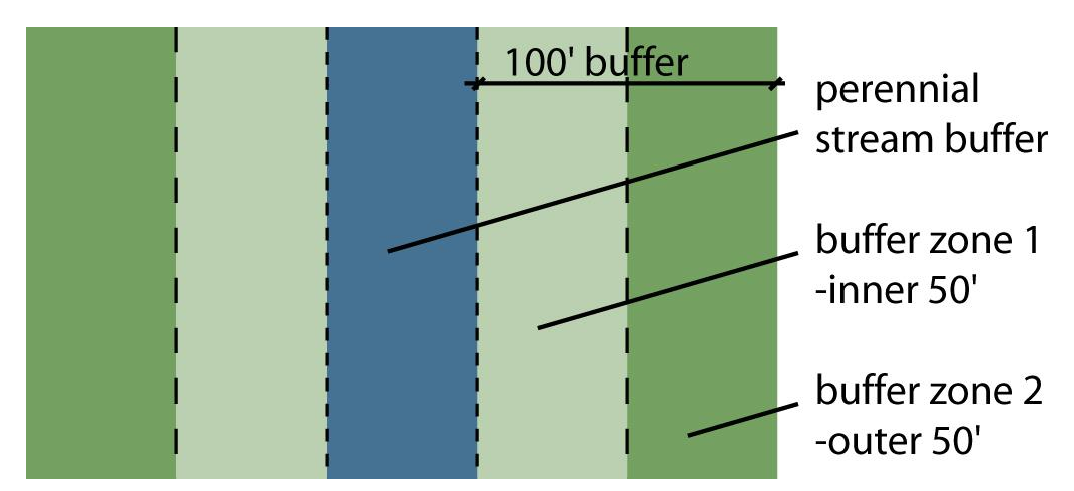
Perennial Streams.
(A)
A water supply watershed buffer with a minimum width of 100 feet must be provided along each side of a perennial stream.
(B)
The buffer width is to be measured perpendicular to the river or stream bank starting at the top of the stream bank.
(C)
The area of the required buffer that begins at the stream bank and extends landward 50 feet is subject to the Zone 1 standards of Sec. Section 11-22-1(A).
(D)
The area of the required buffer that begins at the outer edge of Zone 1 and extends landward 50 feet is subject to the Zone 2 standards of Sec. Section 11-22-1(B).
(E)
There is no minimum building setback from the required buffer.
11-21-6
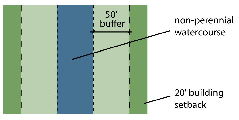
Non-Perennial Watercourses, 25 Acres or More.
(A)
A water supply watershed buffer with a minimum width of 50 feet must be provided along each side of non-perennial watercourses, channels, ditches or similar physiographic features with a drainage area of 25 acres or more that are located inside the watershed draining into the stream.
(B)
The buffer width is to be measured perpendicular to the river or stream bank starting at the top of the stream bank.
(C)
Buildings must be setback at least 20 feet from the outer boundary of the required buffer area.
11-21-7
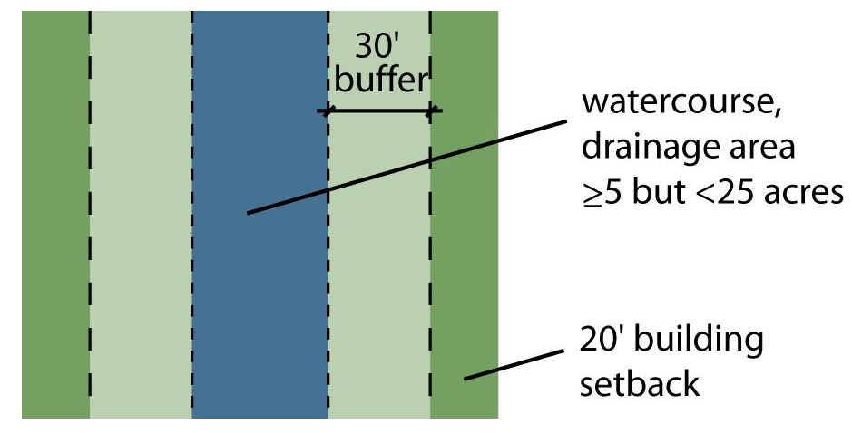
Watercourses and Channels, At Least Five But Less Than 25 Acres.
(A)
A water supply watershed buffer with a minimum width of 30 feet must be provided along each side of a watercourse, channel, ditch, non-water supply impoundment or similar physiographic feature with a drainage area of at least five acres, but less than 25 acres, located inside the drainage area of the drainageway.
(B)
Required buffers are to be measured perpendicular to the river or stream bank starting at the top of the stream bank.
(C)
Buildings must be setback at least 20 feet from the outer boundary of the required buffer area.
[Amended by OA 02-15 on 7/6/2015; Amended on 10/20/2025 by OA-05-25]
11-22 - Activities Allowed Within Buffers.
11-22-1
General.
(A)
The inner 50 feet ("Zone 1") of required 100-foot buffers along perennial streams and all other water supply watershed buffers must consist of a vegetated area that is undisturbed except for the activities expressly allowed to occur within water supply watershed buffers pursuant to subsection 11-22-2.
(B)
The outer 50 feet ("Zone 2") of required 100-foot buffers along perennial streams must consist of a stable vegetated area that is undisturbed except as necessary to accommodate the activities expressly allowed to occur within water supply watershed buffers pursuant to subsection 11-22-2. Grading and revegetation, as well as lawns and landscaping, are allowed within Zone 2 of the perennial stream buffer.
(C)
Any allowed disturbance that occurs as a result of the activities expressly permitted in subsection 11-22-2 must be designed, constructed, and maintained to:
(1)
Minimize impervious or partially impervious surface coverage;
(2)
Diffuse the flow of stormwater runoff, encourage sheet flow and avoid concentrated discharge of stormwater into surface waters;
(3)
Maximize the use of Best Management Practices (BMPs) to minimize adverse water quality impacts; and
(4)
Comply with all applicable standards and conditions of subsection 11-22-2.
11-22-2
Activities Allowed within Buffers. Only the activities listed below are allowed within required water supply watershed buffer areas:
(A)
Archeological activities, provided any vegetation removed is restored with vegetation of a comparable assimilative capacity;
(B)
Bridges, provided no alternative to their location in the buffer exists;
(C)
Dam maintenance activities;
(D)
Drainage ditches, roadside ditches, and stormwater outfalls, provided:
(1)
No alternative to their location in the buffer exists; and
(2)
A stormwater management facility is installed to control nitrogen and attenuate flow before the conveyance discharges through the buffer.
(E)
Drainage of a pond, provided a new vegetated water supply watershed buffer meeting the purpose and requirements of this section is established along the new drainageway;
(F)
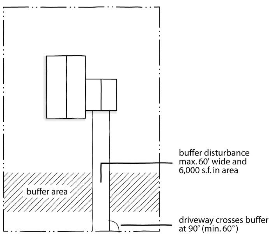
Driveway crossings that access single-family dwellings, provided:
(1)
No alternative to their location in the buffer (including opportunity for shared driveways) exists;
(2)
Buffer disturbance is no more than 60 feet wide;
(3)
Buffer disturbance is no more than 6,000 square feet in area (this area of disturbance may occur on "both" sides of the buffer);
(4)
The driveway crosses the buffer at an angle as close to 90 degrees as possible (and not less than 60 degrees);
(5)
Side slopes do not exceed a 2:1 (horizontal to vertical) ratio (bridging and/or retaining walls may be used to meet this and the disturbance width standard); and
(6)
All culverts are designed and constructed for the 25-year storm event or as otherwise required by the Department of Environmental Services.
(G)
Utility lines, provided:
(1)
No alternative to their location in the buffer exists;
(2)
A line crossing the buffer is combined with other permitted buffer crossings where practicable;
(3)
Buffer disturbance is not more than 40 feet wide;
(4)
Woody vegetation is removed by hand (no land grubbing or grading);
(5)
Vegetative root systems and stumps from cut trees are retained;
(6)
No rip rap is used unless necessary to stabilize a pole or tower;
(7)
Active measures are taken after construction and during routine maintenance to ensure diffuse flow of stormwater through the buffer;
(8)
Mats are used to minimize soil disturbance (in wetlands);
(9)
Poles or towers are not installed within ten feet of the lake, pond, river, stream, or drainageway;
(10)
The area within ten feet of the lake, pond, river, stream, or drainageway is managed so that only vegetation posing a hazard or with a potential to grow tall enough to interfere with the line is removed;
(11)
Construction activities minimize removal of woody vegetation, the extent of disturbed area, and the time during which areas remain in a disturbed state;
(12)
Cables are installed by vibratory plow or trenching; and
(13)
Trenches are backfilled with the excavated material immediately following line installation.
(H)
Pedestrian, bikeway, equestrian, golf cart, and other recreation trails (public or private), provided:
(1)
No alternative to their location in the buffers exists;
(2)
A trail crossing the buffer is combined with other permitted buffer crossings where practicable;
(3)
Buffer disturbance is no more than 20 feet wide (unless otherwise approved by the Department of Environmental Services);
(4)
The trail is no more than 12 feet wide;
(5)
A trail crossing the buffer does so at an angle as close to 90 degrees as possible (and not less than 60 degrees); and
(6)
A trail running linearly within the buffer must be located, where possible, in the outer 20 feet of the buffer and in no instances may such trail be closer than ten feet to the edge of the lake, pond, river, stream or drainageway.
(I)
Railroad crossings, provided:
(1)
No alternative to their location in the buffer exists;
(2)
Buffer disturbance is not more than 60 feet wide; and
(3)
Buffer disturbance is no more than 6,000 square feet in area (this area of disturbance may occur on "both" sides of the buffer).
(J)
Removal of previous fill or debris, provided:
(1)
Diffuse flow is maintained; and
(2)
Any vegetation removed is restored with vegetation of comparable assimilative capacity.
(K)
Road crossings (public or private roads), provided:
(1)
No alternative to their location in the buffer exists;
(2)
Buffer disturbance does not extend beyond the required right-of-way or easement width, or in no case is more than 90 feet wide;
(3)
Buffer disturbance is no more than 9,000 square feet in area (this area of disturbance may occur on "both" sides of the buffer);
(4)
The road crosses the buffer at an angle as close to 90 degrees as possible (and not less than 60 degrees);
(5)
Side slopes do not exceed a 2:1 horizontal: vertical ratio (bridging and/or retaining walls may be used to meet this and the disturbance width standard); and
(6)
All culverts are designed and constructed for the 25-year storm event or as otherwise required by the Department of Environmental Services.
(L)
Scientific studies and stream gauging;
(M)
On-site sewage disposal systems and irrigation of reclaimed water meeting the standards set forth in 15A NCAC 02H .0219 (k) of the North Carolina Administrative Code, provided that such facilities may be located only within areas of water supply watershed buffers that are subject to Zone 2 standards as specified in Sec. 11-21;
(N)
Stormwater management ponds, provided:
(1)
No alternative to their location in the buffer exists; and
(2)
A new vegetated water supply watershed buffer meeting the purpose and requirements of this Paragraph is established around the new pond.
(O)
Stream restoration;
(P)
Stream bank stabilization;
(Q)
Temporary in-stream sediment and erosion control measures for work within a stream channel;
(R)
Vegetation management, including:
(1)
Emergency fire control measures, provided topography is restored;
(2)
Planting vegetation to enhance the buffer's function;
(3)
Pruning forest vegetation, provided the health and function of the vegetation is not compromised;
(4)
Removing individual trees that are in danger of causing damage to dwellings, other structures, or human life;
(5)
Removing poison ivy; and other noxious growth; and
(6)
Removing understory nuisance vegetation as defined in Exotic Plant Guidelines (Guideline #30, NC DENR, Div. of Parks and Recreation, 1998).
(S)
Water-dependent structures;
(T)
Wetland restoration.
11-23 - Building Setbacks from Buffers.
Buildings must be setback at least 20 feet from the outer edge of water supply watershed buffers. In the event of conflict between this buffer setback standard and other applicable standards, the more restrictive standard (the one requiring the greater setback) governs.
11-24 - Platting of Lots.
11-24-1
Options. The inner 50 feet ("Zone 1") of required 100-foot buffers along perennial streams must either be: (1) platted as part of a development lot and included within a conservation easement or (2) set-aside as a reserved conservation parcel, in accordance with the standards of this section.
11-24-2
Development Lots and Reserve Parcels.
(A)
Development Lots. For purposes of this section, "development lots," are lots that are used or intended to be used for principal uses allowed by the underlying zoning district.
(B)
Reserved Conservation Parcels. For purposes of this section, "reserved conservation parcels" are parcels of land that are not used and are not intended to be used for principal uses allowed by the underlying zoning district, but are set-aside to conserve and protect natural areas in perpetuity.
11-24-3
Conservation Easement Option. Under the conservation easement option, the inner 50 feet ("Zone 1") of required 100-foot buffers along perennial streams must be covered by a perpetual conservation easement in accordance with the following standards.
(A)
The inner 50 feet ("Zone 1") of required 100-foot buffers along perennial streams may be platted in development lots only if a perpetual conservation easement is dedicated covering the entire inner 50 feet.
(B)
Conservation easements must run in favor of the Wake County Soil and Water Conservation District or any other recognized land conservation agency approved by the Planning Director.
(C)
The easement grantee must grant permission to authorized employees and agents of Wake County to enter upon the property, inspect, maintain or repair the required buffer whenever the county deems necessary. This provision is not to be interpreted as an express or implicit obligation for the county to maintain or repair buffer areas.
(D)
The grantee of a conservation easement is responsible for ensuring conservation and stewardship of the water supply watershed buffer and for carrying out conservation-related activities. Easement grantees are authorized to assign all or a portion of their conservation and stewardship duties to another appropriate entity approved by the Planning Director.
(E)
A conservation easement and any related access easements must be shown on the record plat, noting the purpose of the easement as well as the names of the grantees and grantors.
11-24-4
Reserve Parcel Option. Under the reserve parcel option, the inner 50 feet ("Zone 1") of required 100-foot buffers along perennial streams must be set aside as reserved conservation parcels in accordance with the following standards.
(A)
The inner 50 feet ("Zone 1") of required 100-foot buffers along perennial streams that is not covered by a conservation easement must be labeled on the plat as a "reserved conservation parcel" and restricted from future use or conveyance as a development lot. Reserved conservation parcels must be dedicated to a property owners' association or recognized land conservation agency.
(B)
Reserved conservation parcels and remnants are exempt from the lot area and width standards of the underlying zoning district and from UDO standards requiring frontage on a public or private road, provided that a pedestrian access easement is provided to the parcel, with a minimum width of ten feet.
(C)
Under the reserve parcel option, development lots may not be platted within the inner 50 feet of required 100-foot buffers along perennial streams.
11-25 - Density and Impervious Surface Calculations.
11-25-1
The land area included within conservation easements and reserved conservation parcels will be included in calculating the allowable density for an open space subdivision.
[Amended on 11/21/2022 by OA-02-22]
11-25-2
The land area included within conservation easements and reserved conservation parcels will be included in calculating the allowable impervious surface coverage within a subdivision.
11-30 - Swift Creek Water Supply Watershed.
11-30-1
Development in the Swift Creek Water Supply Watershed is subject to the requirements of the Swift Creek Land Management Plan in addition to other applicable standards of this ordinance. See also Article 9 of this ordinance.
11-30-2
All non-residential projects require a preliminary site plan prepared by a licensed design professional authorized by the North Carolina General Statutes to perform such work. Residential uses may require a professionally-prepared site plan based on the scale and scope of the project.
11-30-3
An as-built plan prepared by a licensed professional land surveyor is required for all lots before a Certificate of Occupancy may be issued.
11-30-4
In addition to the standards of the underlying zoning districts, the following standards apply to all land within the Swift Creek Water Supply Watershed:
[1] Limit may be increased to 35% if consistent with the impervious surface limitations of the underlying zoning district and the first one inch of rainfall runoff is retained
[2] Limit may be increased to 30% if consistent with the impervious surface limitations of the underlying zoning district and the first ½" of rainfall runoff is retained
[3] Limit may be increased to 30% if consistent with the impervious surface limitations of the underlying zoning district and the first one inch of rainfall runoff is retained
[4] Limit may be increased to 30% and 70% (respectively) if consistent with the impervious surface limitations of the underlying zoning district and the first ½" or one inch of rainfall runoff is retained
[5] Refer to minimum state construction standards and inspection requirements
[6] Point source discharge is prohibited in basin
[7] Municipal sewer is allowed to protect public health when private systems fail
[8] Lots created after 7/01/2001 are subject to Wake County stormwater management regulations
[9] Required if over 12% impervious, public or private maintained
* excludes public, civic and institutional uses such as colleges, schools, public libraries, museums and art galleries
[Amended by OA 05-15 on 12/7/15]
11-31 - Little River Water Supply Watershed.
11-31-1
General Requirements.
(A)
All non-residential projects require a preliminary site plan prepared by a licensed design professional authorized by the North Carolina General Statutes to perform such work. Residential uses may require a professionally-prepared site plan based on the scale and scope of the project.
(B)
An as-built plan prepared by a licensed professional land surveyor is required for all lots before a Certificate of Occupancy may be issued.
11-31-2
Lot Sizes.
(A)
The minimum lot size for all residential lots in the Little River Water Supply Watershed is 40,000 square feet per dwelling unit.
(B)
The minimum lot size for all nonresidential lots in the Little River Water Supply Watershed is 40,000 square feet plus 40,000 square feet for each additional 1,250 gallons per day or portion thereof of anticipated wastewater generated in excess of 1,250 gallons per day.
11-31-3
Impervious Surface Ratios. The following maximum impervious surface ratios apply to all nonresidential development in the Little River Water Supply Watershed:
[Amended by OA 05-15 on 12/7/2015]
11-32 - Smith Creek Water Supply Watershed.
11-32-1
General Requirements.
(A)
All residential and commercial properties require a preliminary site plan prepared by a licensed professional land surveyor, landscape architect, architect or engineer effective July 2, 2001.
(B)
An as-built plan prepared by a professional land surveyor is required for all lots before a Certificate of Occupancy may be issued.
11-32-2
Lot Sizes.
(A)
The minimum lot size for all residential lots in the Smith Creek Water Supply Watershed is 40,000 square feet per dwelling unit.
(B)
The minimum lot size for all nonresidential lots in the Smith Creek Water Supply Watershed is 40,000 square feet plus 40,000 square feet for each additional 1,250 gallons per day or portion thereof of anticipated wastewater generated in excess of 1,250 gallons per day.
11-32-3
Impervious Surface Ratios. The following maximum impervious surface ratios apply to all nonresidential development in the Smith Creek Water Supply Watershed: