
Wake County Unincorporated
City Zoning Code
City Zoning Code
ARTICLE 8
- Subdivision Design and Improvements
8-10 - Jurisdiction; Applicability.
8-10-1
The subdivision design and improvements standards of this Article apply to all subdivisions of land within unincorporated Wake County, outside the extraterritorial jurisdiction or incorporated boundaries of any municipality.
8-10-2
The subdivision design and improvement standards of this Article also apply to all subdivisions of land within the extraterritorial jurisdiction or incorporated boundaries of any municipality when the governing body of the subject municipality has, by resolution, authorized Wake County to exercise subdivision review authority within such area.
8-10-3
Occasionally, proposed subdivisions are located within multiple jurisdictions (i.e., partially within unincorporated Wake County and partially within other jurisdictions). In such cases, the Planning Director is authorized to require that the entire subdivision be designed and developed in accordance with the regulations of the jurisdiction that imposes the strictest standards. Alternatively, the Planning Director may simply allow portions of the proposed subdivision lying within multiple jurisdictions to be designed and developed in accordance with the standards of the applicable jurisdictions. The Planning Director is not authorized to relax or waive applicable subdivision design/improvement standards unless otherwise expressly stated in this ordinance.
8-11 - Activities that Constitute a Subdivision.
Except as expressly stated in Sec. 8-12, any division of a tract or parcel of land into two or more lots, building sites, or other divisions for the purpose of sale, building or development (whether immediate or future) constitutes a subdivision, including any division that involves the dedication of a new public or private road or a change in an existing public or private road.
8-12 - Activities that do not Constitute a Subdivision; Exemptions.
The following activities do not constitute a subdivision and are expressly exempt from the design and improvement standards of this Article, provided that the property's exempt status is confirmed in accordance with the procedures of Sec. 19-30:
8-12-1
The division of a tract of land in single ownership into no more than three lots if:
(A)
The tract to be divided is no greater than two acres in area;
(B)
No road right-of-way is dedicated; and
(C)
The resulting lots meet or exceed the minimum standards of this ordinance (such as, but not limited to minimum lot size and minimum road frontage).
[Amended on 4/21/2014 by OA 07-12]
8-12-2
The division of land resulting in the creation of parcels that are each more than ten acres in area, provided that no right-of-way is dedicated
8-12-3
The combination or recombination of portions of previously subdivided and recorded lots if:
(A)
The total number of lots is not increased;
(B)
The resulting lots meet or exceed the subdivision design and improvements standards of this Article; and
(C)
No nonconformities are created.
8-12-4
The public acquisition of land for the establishment (or widening) of roads, rail corridors, parks, open space, trails, greenway corridors, conservation areas, or public water reservoir projects;
8-12-5
The creation of Reserved Conservation Parcels under the requirements of Article 11, Part 2 (Water Supply Watershed Buffers) and Sec. 8-43, Special Requirements in Water Supply Watersheds;
8-12-6
The division of land into cemetery plots;
8-12-7
The division of land solely for the purpose of creating lots to be occupied by electrical substations, water towers, community water and wastewater systems, cell towers and similar structures used for public or quasi-public utility purposes, provided no road right-of-way is dedicated; and
8-12-8
The division of a tract of land resulting solely from public acquisition of land to be used for public road right-of-way.
8-12-9
The division of a tract into parcels in accordance with the terms of a probated will or in accordance with intestate succession under Chapter 29 of the General Statutes.
[Amended on 3-19-2018 by OA 02-17]
8-13 - Review and Approval of Subdivisions.
8-13-1
No plat of a land division may be accepted for recordation or recorded with the Register of Deeds until the Planning Director has either:
(A)
Certified in writing that the proposed land division does not constitute a subdivision, in accordance with Sec. 19-30; or
(B)
That the land division constitutes a subdivision and has been reviewed and approved in accordance with the applicable procedures of Sec. 19-32 through Sec. 19-37
8-13-2
No subdivision or exempt land division may be executed solely by deed instrument. All applications for subdivisions or exempt land division must bear the signature(s) of the owner(s) of the property for which the application is being made.
8-14 - Compliance with Plans and Other Applicable Regulations.
8-14-1
It is intended that subdivisions will be designed to be consistent with the spirit and intent of the Comprehensive Plan, the Transportation Plan, Greenway System Plan, and the Consolidated Open Space Plan.
[Amended on 11/21/2022 by OA-02-22]
8-14-2
Subdivisions and lots created under this ordinance must comply with all applicable federal, state and county regulations.
8-15 - Phasing.
A subdivision may be developed in phases, provided that:
8-15-1
Each phase contains at least six lots, unless shown on a phasing plan approved as part of the preliminary subdivision plan with the express determination that the proposed phasing makes it unlikely that a subdivider would willingly abandon a final phase that contains a required extension of a road or other infrastructure;
8-15-2
A phasing plan showing the phases of development and the requirements of this ordinance that will be satisfied in each phase is approved as part of the preliminary plan;
8-15-3
The number of lots and amount of required open space in the phase and any previously approved phases is proportional; and
8-15-4
The degree and extent of road, water supply, sewage disposal, stormwater management, erosion and sedimentation control, and other required improvements in the phase and previously approved phases is sufficient to serve or handle all development within the phase.
8-20 - Improvements Required.
8-20-1
Subdividers are responsible for the construction, installation, and maintenance of the following improvements in accordance with the standards in this ordinance in addition to any applicable federal, state, county or municipal standards.
(A)
All roads within the subdivision and improvements to existing roads required for safe and adequate access to the subdivision as may be required by this ordinance;
(B)
Road signs;
(C)
Water supply and wastewater systems, other than individual wells and septic tanks;
(D)
Drainage facilities and easements;
(E)
Stormwater management devices;
(F)
Erosion and sedimentation control devices; and
(G)
Any other on- or off-site improvements required by this Article or required at the time of preliminary plat approval.
8-20-2
If the subdivider files a record plat for only a portion of the subdivision for which a preliminary plat was approved, the improvements required to be constructed, installed, and maintained in accordance with that record plat must be those improvements that the Planning Director deems necessary to serve the lots shown on the record plat.
8-21 - Completion of Improvements.
8-21-1
The Planning Director may not approve a final plat presented for recordation until all required improvements have been completed.
8-21-2
An improvement will be deemed completed only after the appropriate public agency certifies that the improvement has been installed in accordance with the approved preliminary plat and construction plan. In the case of public roads, certification from NCDOT must be provided stating all roads in the applicable phase(s) have been constructed to the minimum standards for acceptance by the agency. In lieu of certification from a public agency for private roads, the Planning Director is authorized to accept certification from the applicant's licensed professional engineer or licensed professional surveyor or other professional as authorized by the North Carolina General Statutes that the improvements have been installed in accordance with all applicable standards.
[Amended on 2/15/2016 by OA 06-15]
8-22 - Performance Guarantees.
8-22-1
Purpose.Performance guarantees are required for the purpose of ensuring that developers properly install required improvements, such as private roads, stormwater devices and landscaping, etc., in a timely manner, in accordance with approved plans, plats and construction plans. Performance guarantees are not eligible for roads which are intended to be public.
8-22-2
Term.The term of a performance guarantees will be established upon the execution of the performance guarantee agreement. The Planning Director may, for good cause and with the approval of the provider of the guarantee, grant up to two extensions of the term, with each such extension not to exceed one year.
8-22-3
Form and Amount of Performance Guarantee.
(A)
The form of guarantee is to be determined by the developer. The performance guarantee must be conditioned upon the performance of all work necessary to complete the required improvements within the time period specified in the agreement.
(B)
The amount of the performance guarantee must equal 125 percent of the estimated cost of completion of the required improvements, which have not been accepted for ownership and/or maintenance by the applicable legal entity by the time of Record Plat submittal or site approval.
(C)
The estimated total cost of required improvements must be itemized by improvement type and certified by the applicant's licensed professional engineer or other authorized professional. In the case of minor subdivisions, the applicant's licensed professional engineer, or other licensed professional as authorized by North Carolina General Statute, may provide the itemized cost estimate. Cost estimates must be based on industry norms within Wake County.
8-22-4
Draws Against Performance Guarantee. Should a developer fail to properly install required improvements within the term of the guarantee, the guarantee will be deemed in default. In the case of default, the county is authorized to use the guarantee funds to complete the required subdivision improvements or to let a contract for installation of the required improvements.
8-22-5
Release of Performance Guarantee. Once the conditions of the performance guarantee have been completed to the satisfaction of the appropriate agencies, the guarantee must be released. No guarantee may be released until all required certifications of completion have been provided.
[Amended by OA 03-13 on 12/2/2013; Amended on 2/15/2016 by OA 06-15]
8-23 - Maintenance of Required Improvements.
The subdivider is responsible for maintenance of all required improvements, including roads and their associated rights-of-way, to the standards of this ordinance until such time as a unit of government, public or private utility, homeowner association, property owners association, lot owner, or other legal entity assumes formal, legal responsibility for maintenance of the improvements. The record plat must include the subdivider's signed and notarized acknowledgement of this responsibility. The subdivider must also provide each prospective buyer of any lot shown on the record plat with written disclosure of the subdivider's responsibility for maintaining required improvements. Failure to maintain improvements will constitute a violation of the ordinance and be subject to enforcement action by the county.
[Amended on 2/15/2016 by OA 06-15]
8-24 - Reserved for future use.
Editor's note— OA 06-15, adopted February 15, 2016, repealed § 8-24 which pertained to maintenance\guarantees.
8-25 - Property Owners Associations.
8-25-1
Establishment. If a property owners association is to be responsible for the maintenance and control of private roads, open space, recreational facilities, or other common areas and facilities within a subdivision, that association must have legal authority to maintain and exercise control over the common areas and facilities, including the power to compel contributions from residents or property owners to cover their proportionate share of the costs associated with the maintenance of the common areas and facilities.
8-25-2
Documentation.
(A)
Documents providing for the establishment of a property owners association must be submitted to the Planning Director before approval and recordation of a record plat.
(B)
The county's review is limited to ensuring that the property owners association has clear legal authority to maintain and exercise control over the common areas and facilities, including the power to compel contributions from residents and property owners to cover their proportionate share of the costs associated with the maintenance of the common areas and facilities.
8-30 - Natural, Agricultural and Historic/Cultural Resources.
In the layout and design of a subdivision, due consideration should be given to preserving natural features (e.g., woodlands, steep slopes, rock outcroppings, ponds, streams, rivers, and lakes), agricultural resources (e.g., Voluntary Agricultural District, Enhanced Voluntary Agricultural District, conservation easement), as well as the preservation of historic and cultural resources (e.g., homesteads, mills, barns, archeological sites) that are of value to the county as a whole. In identifying and making determinations regarding agricultural resources, the county and the applicant should identify existing voluntary agricultural districts, enhanced voluntary agricultural districts, and permanent conservation easements either on or adjacent to the proposed subdivision. In identifying and making determinations regarding the presence of cultural and historic resources, the county and the applicant should consult the most current editions of sources such as the Wake County Survey of Historic Properties, the Wake County Historic Landmarks, properties listed in the National Register of Historic Places and properties listed in the North Carolina State Historic Preservation Study List. If any combination of natural features, agricultural resources, historic resources or cultural resources exist on or adjacent to the proposed subdivision, the County and the applicant shall meet and discuss further measures that can be taken for preservation and protection purposes that the Planning Director may require.
[Amended on 11/21/2022 by OA-02-22]
8-31 - Lots.
8-31-1
Development Options. Lots may be designed and laid out to comply with the conventional development standards of Sec. 5-1 or the open space development standards of Sec. 5-12.
[Amended on 11/21/2022 by OA-02-22]
8-31-2
Lots with Road Easements. Lots may not be platted within private road easements.
8-31-3
Oversized Lots. Whenever a subdivision includes one or more lots of such size that they may eventually be resubdivided into smaller lots, the applicant may be required to dedicate easements to provide for future road access to landlocked or potentially landlocked parcels. The width of such easement is to be determined in accordance with the standards of Sec. 8-32-5(D).
8-31-4
Flag Lots.
(A)
Policy. It is the policy of the county to discourage and restrict the creation of flag lots.
(B)
Exception.
(1)
The Planning Director, as applicable, is authorized to allow the creation of flag lots only if it is determined that a flag lot is necessary to allow reasonable use and benefit of the subject parcel or to alleviate situations that would otherwise cause undue hardship. Flag lots may be allowed only in the following instances:
(a)
When necessary to eliminate access onto thoroughfares;
(b)
When necessary to make reasonable use of irregularly shaped parcels;
(c)
When necessary to make reasonable use of parcels with severe topography; or
(d)
When necessary to provide suitable land area and soil for location and operation of utilities.
(2)
The applicant is responsible for demonstrating that at least one of the instances described in paragraph (1), above, exists.
(C)
Measurement of Minimum Lot Width. Minimum lot width for a flag lot must be measured along a line parallel to the abutting road frontage. The lot's width must be measured at a point:
(1)
No more than 300 feet from the road right-of-way in R-80 and R-80W zoning districts;
(2)
No more than 250 feet from the road right-of-way in R-40 and R-40W zoning districts; and
(3)
No more than 200 feet from the road right-of-way in all other zoning districts.
8-32 - Roads.
8-32-1
Purpose. The road standards of this section are intended to ensure:
(A)
An integrated system of roads that provides safe and efficient traffic circulation;
(B)
The efficient movement of through traffic by providing an interconnected system of roads;
(C)
Uncomplicated road layouts so that emergency service personnel, public service personnel and visitors can find their way to and from destinations; and
(D)
Controlled access to thoroughfares.
8-32-2
Applicability. The standards of this section apply to all public and private roads, unless otherwise expressly stated. The standards apply to new roads as well as extensions of existing roads.
Commentary: Other local, state, or federal agencies may require more stringent standards than those stated in this Ordinance. For example, the Fire Marshal may require a 20' travel way for all roads that serve more than two lots, or temporary turnarounds on any stub road deemed necessary. In the case of conflicting provisions, the more stringent provision shall apply.
8-32-3
Road Frontage Required.
(A)
Each new lot within a subdivision must abut and have access to an existing or proposed public or private road that complies with all applicable standards of this ordinance.
(B)
Residential subdivisions involving more than three lots must be served by internal road systems rather than relying on state roads for direct access to lots.
(C)
If direct driveway access to state roads is allowed, the Planning Director is authorized to require shared access drives and other mitigation measures to reduce the number of access points on to state roads and thereby promote public safety and efficient movement of traffic.
(D)
Each road within, abutting, or adjacent to a proposed subdivision must be designated as either public or private.
8-32-4
Public Roads.
(A)
Public roads must be designed in accordance with the Minimum Construction Standards for Subdivision Roads established by the North Carolina Department of Transportation, Division of Highways. When other Wake County regulations impose higher or more restrictive standards, the higher or more restrictive standard governs.
(B)
Within the Walkable, Community, and Community Reserve areas identified on the Comprehensive Plan Development Framework Map, the Planning Director may require that roads serving 12 or more lots be designed and constructed in accordance with applicable municipal standards.
(C)
Designation of any road on a plat as public will be conclusively presumed to be an offer of dedication to the public.
[Amended on 11/21/2022 by OA-02-22]
8-32-5
Private Roads.
(A)
Intent. The private road standards of this section establish private road design and construction standards that vary based on the number of lots such roads will serve. These standards are intended to ensure public safety and the long-term durability of private roads while keeping public improvement costs as low as possible for the smallest of subdivisions.
(B)
Designation. Private roads must be designated on subdivision plats as either "existing," "new," or "extended," in accordance with the standards of this subsection (§§8-32-5).
(1)
Existing Private Roads.
(a)
Private access easements or roads, the existence of which as of September 21, 1989, can be established by documentary evidence, aerial photograph, or judicial decree, will be considered existing private roads.
(b)
All other private roads are either new private roads or extensions of existing private roads.
(c)
When no new private road or extensions of existing private road is proposed, then that portion of the existing private road that serves as frontage for lots in the subdivision must meet or exceed all applicable private road standards.
(d)
Where a permanent means of ingress and egress was created as part of the minor-limited development, it must be upgraded to comply with the private road standards of this Article from the portion of the permanent means of ingress and egress that serves as frontage for lots in the subdivision to the nearest improved public or private road.
(2)
New or Extended Private Roads.
(a)
New or extended private roads that serve as frontage for lots must meet or exceed private road standards.
(b)
Where an extension of an existing private road is proposed, thereby increasing the potential for additional traffic, the Planning Director is authorized to require that the connecting private road, if any, be upgraded to comply with the private road standards of this Article.
(C)
Class A and Class B Private Roads. Two types of private roads are allowed, depending on the number of lots to be served.
(1)
"Class A" private roads are allowed only when the proposed private road will provide or have the potential to provide access to an area with an ultimate development potential of seven or more lots.
(2)
"Class B" private roads are allowed only when the proposed road will provide or have the potential to provide access to an area with an ultimate development potential of six or fewer lots. No extension of a "Class B" private road will be allowed if such extension will provide or have the potential to provide access to an area with an ultimate development potential of more than six lots. Extensions of such roads that will result in the provision of more than six lots may be allowed only if the entire length of the road is brought up to applicable "Class A" private or public road standards (depending on the number of lots to be served).
(3)
For the purpose of determining "ultimate development potential," the Planning Director must consider the number of lots within the subject subdivision that will have access to the proposed road and to the likelihood that the proposed road will or could be extended to adjoining property.
(4)
No subdivision plat that shows lots served by private roads may be recorded unless the record plat contains the following notation: "further subdivision of any lot shown on this plat may be prohibited unless the private road is improved in accordance with applicable standards."
(5)
Within the Walkable, Community, and Community Reserve areas identified on the Comprehensive Plan Development Framework Map, the Planning Director may require that all roads be designed and constructed in accordance with applicable municipal standards.
(D)
Design and Construction Standards. The following design and construction standards apply to Class A and Class B private roads.
[1] Curb and gutter are limited in water supply watersheds. See Sec. 8-32-18(C).
(E)
Disclosure. The Record Plat for a subdivision containing private roads must include the following disclosure statement:
This disclosure is given in accordance with North Carolina General Statutes 136-102.6.
This statement is to advise that the roads serving this subdivision are designated
as private roads, not public roads. All owners of property within the subdivision
have easements with one another to travel over and across such roads. The responsibility
for maintenance of such private roads falls solely upon the property owners within
the subdivision. No representation is made that the private roads within this subdivision
meet the minimum requirements necessary to allow such roads to be included in the
state secondary road system or that the North Carolina Department of Transportation
will eventually assume maintenance such roads. Moreover, if such private roads are
not adequately constructed and maintained, emergency service providers and public
service vehicles may be unable to provide adequate service to the residents of the
subdivision.
______________________________________ ____________________
Subdivider Date
(See NCGS 136-102.6(f) for subdivision street disclosure statement requirements)
(F)
Maintenance; Property Owners Associations.
(1)
A property owners association is required to own and maintain all private roads.
(2)
The subdivider must submit to the Planning Director proposed agreements or covenants ensuring continued use and maintenance of any existing, platted or proposed private roads by property owners served by such roads. These agreements will require that proposed private roads be adequately maintained to provide safe passage for public service and emergency vehicles, will specify how responsibility for road maintenance will be apportioned among the landowners served, and will provide enforcement rights for the maintenance agreement. The adequacy of such agreements must be demonstrated to the reasonable satisfaction of the Planning Director.
[Amended on 11/21/2022 by OA-02-22; Amended on 11/18/2024 by OA-01-24]
8-32-6
Right-of-way Dedication.
(A)
Except as otherwise expressly indicated in this ordinance, whenever a tract to be subdivided includes or abuts any part of a road that has a right-of-way of less width than required by applicable state or county standards, the property owner is required to dedicate the additional right-of-way necessary to ensure compliance with minimum right-of-way width standards.
(B)
When a road or highway corridor established and adopted pursuant to Sec. 136-66.2, NCGS, is located on or adjacent to a proposed subdivision, the landowner must dedicate right-of-way needed to construct or widen the road to the right-of way width indicated in the Transportation Plan if all of the following conditions are met:
(1)
There is a reasonable relationship between the proposed street or highway right-of-way requested to be dedicated and the traffic that will be generated by the proposed development.
(2)
The dedication of right-of-way does not result in the denial of a reasonable use of the original tract of land.
(3)
The right-of-way dedication is mitigated by the transfer of density credits attributable to the dedicated right-of-way to the same parcel or contiguous land owned by the applicant.
8-32-7
Right-of-Way Reservation. If any part of a subdivision lies within the corridor of a thoroughfare shown on a Roadway Corridor Official Map adopted pursuant to North Carolina General Statutes Chapter 136, Article 2E, no subdivision approval may be granted with respect to the property located within the roadway corridor. Provided, however, that no subdivision plat approval may be delayed for more than three years after the date the application for plat approval has been accepted by the Planning Director as complete.
8-32-8
Improvements Identified in Traffic Impact Analysis.
(A)
When a Traffic Impact Analysis (TIA) is required pursuant to Sec. 15-12, the subdivision must include those on- and off-site transportation improvements or other impact mitigation measures deemed necessary to ensure compliance with the Level of Service Standards of Sec. 15-12-3.
(B)
Wake County desires to assure both that development impacts are mitigated through contributions of street rights-of-way and transportation system improvements and those new developments contribute their fair share of the costs of transportation improvements.
(C)
There must be a rough proportionality between the traffic impacts created by a new development and requirements placed on the property owner or applicant to dedicate and improve off-site, abutting and internal roads. It is the county's intent to ensure that mandatory dedications of street rights-of-way and street construction requirements are proportional to the traffic demands created by a new development. In other words, the individual property owners should not be required to pay for a community improvement and when that cost more fairly lies with the "public as a whole."
8-32-9
Road Signs.
(A)
All roads in the county shall be identified by a sign showing the official name and state road number. These signs shall be placed at all intersections and shall identify both intersecting streets.
(B)
Road name signs shall be uniform throughout the county in accordance with the Governor's Highway Safety Commission Program.
8-32-10
Road Names and Addresses.
(A)
A name must be assigned to any public road, private road, or easement that provides vehicular access to two or more parcels.
(B)
The names of new roads may not duplicate or be so phonetically similar to the name of an existing road within the county that such names might create confusion. Changes in or additions to road names accomplished solely by the substituting "street," "road," "drive," "place," "court," "boulevard," "way" or other similar terms are not an acceptable means of differentiating identical or phonetically similar road names.
(C)
The names of roads and addresses of individual lots must be reviewed and approved as part of the Record Plat approval process, following a review and recommendation of the GIS division of the Community Services Department.
(D)
Roads that extend or continue existing roads must be given the same name as the existing road, unless otherwise approved by the Planning Director.
(E)
Administration, application, display of road addresses, and enforcement shall be in accordance with Wake County Ordinance Title VII Emergency Management, Chapter 71 Road Names.
8-32-11
Road Layout.
(A)
The arrangement, character, extent, width, grade, and location of all roads must be in keeping with existing and proposed transportation patterns, topographical and other natural features, public convenience and safety, and proposed uses of lands to be served by such roads.
(B)
The proposed road layout within a subdivision must be coordinated with the existing and proposed road network (as established in the Transportation Plan and by the existing and proposed road network within existing and approved subdivisions), including the extension and interconnection of roads between adjacent properties where appropriate to the development of a local road network.
(C)
A network of extended and interconnected local roads is intended to provide each parcel in the general area the safe, convenient, and efficient means of access that will ensure orderly development and effective and efficient provision of emergency and public services and help avoid degradation of existing roads.
(D)
On a residential corner lot, nothing shall be erected, placed, planted or allowed to grow in such a manner as to materially block vision between a height of three and ten feet above the centerline grades of the intersecting streets in the area inscribed by triangles formed by connecting the point ten feet from the corner of the right-of-way along the street with lesser traffic volume and 70 feet from the corner of the right-of-way along the street of higher traffic volume, unless otherwise required by the NCDOT.
8-32-12
Road Connections to Abutting Property. The standards of this subsection are intended to ensure development of a safe and efficient road network that serves the subject property and the surrounding area. The standards generally require that new subdivisions be provided with at least two means of access, except where properties are accessed by a cul-de-sac that complies with paragraph 8-32-17(A).
(A)
Minimum Number of Connections.
(1)
All new subdivisions with fewer than 100 dwelling units must provide at least one stub-out street to extend and connect with future streets.
(2)
All new subdivisions with 100 or more dwelling units must include street connections or stubs at a ratio of at least one stub/connection per 100 dwelling units or fraction thereof.
(B)
Additional Connections.
(1)
Additional road connections or stub-out streets—in excess of the minimum requirements of Sec. 8-32-12(A)—must be provided to adjacent property or a connecting road whenever the Planning Director determines:
(a)
That such extension or connection is necessary to ensure development of a safe and efficient local road network that serves the subject property and the surrounding area; or
(b)
That such extension is necessary to implement the Transportation Plan.
(2)
No more than one road extension or connection may be required for the sole purpose of providing access to a single landlocked parcel, but more than one road extension or connection may be required for the purpose of safe and efficient traffic circulation on the county road network.
(3)
All adjacent properties must be considered when determining appropriate locations for road extensions and connections.
(C)
Access to Multiple Thoroughfares. Any subdivision with frontage on two or more thoroughfares must be provided with road access to each such thoroughfare. This standard also applies when a subdivision is separated from thoroughfare frontage by contiguous land under the same ownership as the subject subdivision.
(D)
Responsibility for Construction. When adjacent land is already developed with stub-out connections, new development must build the street connections, including required collector street connections.
(E)
Road Extensions and Connections Not Feasible or Desirable.
(1)
Road extensions and connections are required pursuant to this section except when the Planning Director determines that any of the following conditions exist:
(a)
Physical barriers or environmentally sensitive areas should not be crossed (for example, railroads, watercourses, steep topography, or flood areas);
(b)
The road would connect properties with zoning or land uses that are incompatible, and the connection would create traffic patterns and volumes that are detrimental to residential uses within the subject subdivision;
(c)
Other more desirable and readily available road connections are available to the adjacent parcel;
(d)
The road extension or connection would provide a direct connection between thoroughfares and would encourage through traffic at levels inappropriate for the type of road provided (for instance, it might be appropriate to provide such a connection with a collector road rather than with a local road); or
(e)
The road extension or connection would connect to property for which development rights have been sold for a public purpose and access to the property is not desirable for orderly development of the road network.
(2)
If the Planning Director determines that a road extension or connection to abutting property is not feasible because natural barriers (e.g., rivers, lakes, ponds, steep slopes, or flood hazard areas) or other intervening man-made barriers (e.g., railroads, freeways, parks, or existing development) make it impractical to extend the road to such property, the subdivider must grant an easement for the road to the benefit of the adjacent property. The easement must:
(a)
Give the current and future owners of the adjacent property the right to construct the road as either a public or private road and to dedicate the easement as a public road right-of-way if the road is constructed as a public road; and
(b)
Have a minimum right-of-way width of 50 feet and include temporary construction easements of at least ten feet in width on each side of the right-of-way to allow the construction of a public road meeting the standards of this ordinance.
(3)
In addition to the easement specified in paragraph (2) above, the Planning Director is also authorized to require a financial guarantee or enforceable legal agreement ensuring that the subject developer participates in funding the road extension or connection in the event that such extension or connection becomes feasible in the future.
8-32-13
Stub Roads. The following standards apply to all stub roads:
(A)
A temporary turnaround (either a standard bulb cul-de-sac or T-turnaround) must be provided at the end of any stub road in excess of 400 feet in length that is planned for extension into future sections of the subdivision or onto adjacent property. Temporary turnarounds must comply with the following:
(1)
The turnaround must be constructed in a temporary easement, located either on-site or off-site;
(2)
The developer of the adjacent property making a road connection to the existing stub road is responsible for the removal of the turnaround and for the restoration of the area at the time that the road connection is made;
(3)
The turnaround must comply with the cul-de-sac or T-turnaround dimensional standards of this Article; and
(4)
The turnaround must be surfaced in accordance with that standards that apply to "Class B" private roads.
(B)
Additionally, any plat containing a stub road must include the following note: "The road system shown on this plat includes one or more stub roads that are intended to be connected to the adjacent property at such time that the property is developed. The interconnection of neighborhoods with a road network ensures the efficient flow and dispersal of traffic and provides for additional points of ingress and egress for emergency vehicles."
8-32-14
Access to Thoroughfares.
(A)
Purpose. This regulation is intended to promote traffic safety and efficient traffic operation and circulation by controlling direct vehicle access points onto thoroughfares.
(B)
Standards. No direct access from individual lots onto a thoroughfare is allowed, provided that when strict compliance with this provision is impossible or impractical due to topographic conditions, configuration of the parcel to be subdivided or other conditions beyond the control of the subdivider, the Planning Director is authorized to approve other means of meeting the purpose of this subsection. When a tract of land to be subdivided borders on an existing or proposed thoroughfare, the Planning Director is authorized to require any of the following:
(1)
That rear or side setbacks abut the thoroughfare and that front setbacks abut another road;
(2)
That a new parallel local road be created and that roads internal to the subdivision intersect the local road at a right angle;
(3)
That a marginal access or service road be constructed parallel to and separated by a landscaped strip from the thoroughfare (In such cases, the access or service road may have reasonable access to the thoroughfare and must serve as the principal access road to the subdivision); or
(4)
That another access design, such as joint driveways, be used to achieve the intent of this regulation.
(C)
Criteria. The Planning Director must consider the following criteria in determining which of the thoroughfare access standards of paragraph 8-32-14(B) to require:
(1)
The thoroughfare's road classification;
(2)
Traffic counts as related to capacity;
(3)
Level of traffic congestion and level of service (LOS);
(4)
Ultimate cross-sectional design of the thoroughfare;
(5)
Alignment of the access point with existing roads;
(6)
Types of vehicles likely to be using the access;
(7)
Separation of the access point from existing and proposed intersections; and
(8)
The sight distance of approaching traffic from the point where any proposed access intersects the thoroughfare.
(D)
Separation of Access Points. When a subdivision or a lot within a subdivision is allowed to have direct access to a thoroughfare by way of a driveway or intersecting road, the allowed access point must be separated from other access points along the thoroughfare in accordance with all applicable NCDOT and county standards.
(E)
Turn Lanes. When a subdivision or a lot within a subdivision is allowed to have direct access to a thoroughfare by way of a driveway or intersecting road, left-turn storage or right-turn deceleration lanes may be required in accordance with all applicable NCDOT and county standards and all requirements of the Transportation Plan.
8-32-15
Intersection Design.
(A)
All roads must intersect as nearly as possible at right angles, and no road may intersect with another at an angle of less than required under the NCDOT standards or the standards of Sec. 8-32-5(D), whichever are applicable.
(B)
When a centerline offset (jog) occurs at an intersection, the distance between the centerlines of the intersecting roads may not be less than required by NCDOT standards for public roads. The centerline offset at intersections of private roads must comply with the standards of Sec. 8-32-5(D).
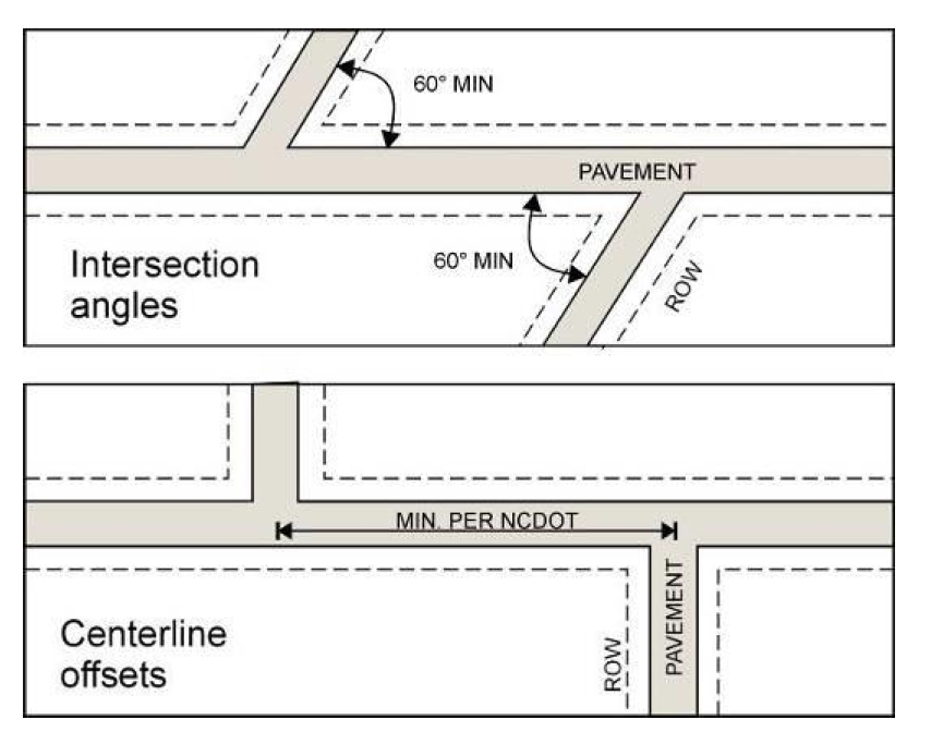
(C)
An intersection may not include more than four road approaches.
8-32-16
Half Roads. The dedication of half roads at the perimeter of a new subdivision is prohibited except along thoroughfares. When a half road exists along the perimeter of an adjoining subdivision, the remaining half must be provided by the proposed subdivision.
8-32-17
Cul-de-Sacs.
(A)
Length.
(1)
Cul-de-sacs may not exceed 2,500 feet in length. A cul-de-sac's length is measured from the center point of its turnaround, along the centerline of its right-of-way to the centerline of the right-of-way of the nearest intersecting road.
(2)
The Planning Director is authorized to increase the cul-de-sac length limit of paragraph 8-32-17(A)(1) by up to 35 percent if they determine, based on evidence submitted by the subdivider, that:
(a)
It is impracticable to provide the area proposed to be served by the cul-de-sac a second means of access that would avoid the cul-de-sac or allow the cul-de-sac to meet the cul-de-sac length limit because:
i.
Intervening floodplains, wetlands, steep slopes or other natural features make it impracticable to provide the area a second means of access that would avoid the cul-de-sac or allow the cul-de-sac to meet the cul-de-sac length limit (e.g., by providing a loop road into the area of the cul-de-sac, or extending the cul-de-sac to connect to another road in the subdivision); and
ii.
Other properties adjoining the area have already been subdivided or developed in a manner that precludes connecting the cul-de-sac to an existing or potential road system, or the area is so separated from adjoining properties by existing or proposed public parks or conservation areas or by floodplains, wetlands, steep slopes or other natural features that make it impossible or impracticable to extend or connect the cul-de-sac to the adjoining properties.
(b)
Use of open space subdivision provisions would not reasonably allow both compliance with the cul-de-sac length limit of paragraph 8-32-17(A) and realization of at least 80 percent of the maximum density allowed by the site's zoning and physical characteristics; and
(c)
The proposed degree of increase in allowable cul-de-sac length is the minimum necessary to allow the above findings.
(B)
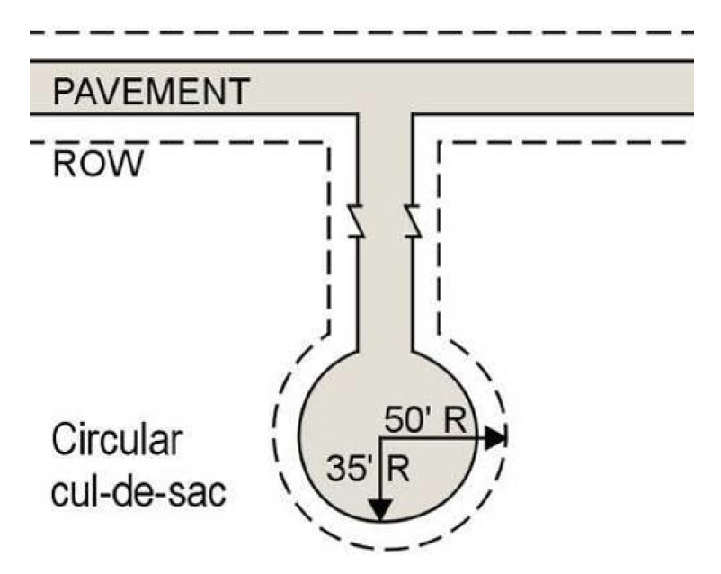
Cul-de-sacs on Public Roads and "Class A" Private Roads. Public roads and "class A" private roads must be designed and constructed in accordance with NCDOT standards, except as otherwise expressly stated in this ordinance.
(C)
Cul-de-sacs on "Class B" Private Roads.
(1)
"Class B" private cul-de-sac roads must be provided at the closed end with a circular turnaround having a minimum driving surface radius of 35 feet and minimum right-of-way radius of 50 feet.
(2)
The Planning Director is authorized to approve "class B" private cul-de-sac road design alternatives (to the standards in subparagraph 8-32-17(C)(1)) only if the subdivider provides evidence of all of the following:
(a)
The property has characteristics such as unsuitable soils, steep slopes, or unusual parcel configuration which cause site design difficulties beyond the control of the property owner;
(b)
Requiring compliance with the standards of 8-32-17(C)(1) would cause practical difficulties or unnecessary hardship for the property owner; and
(c)
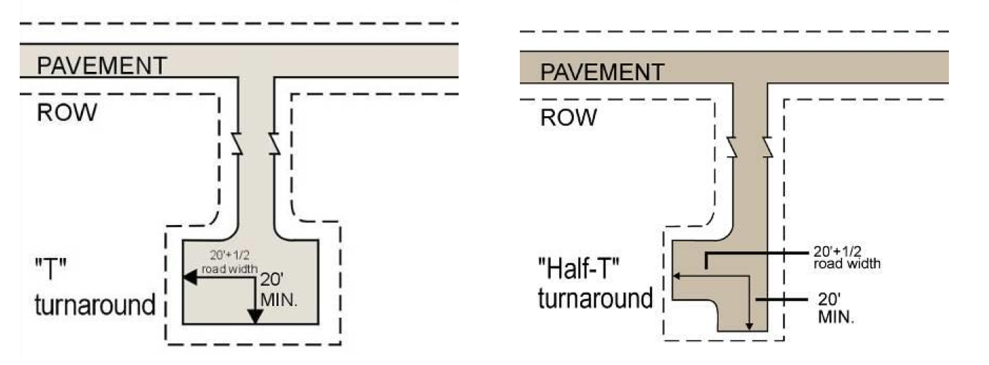
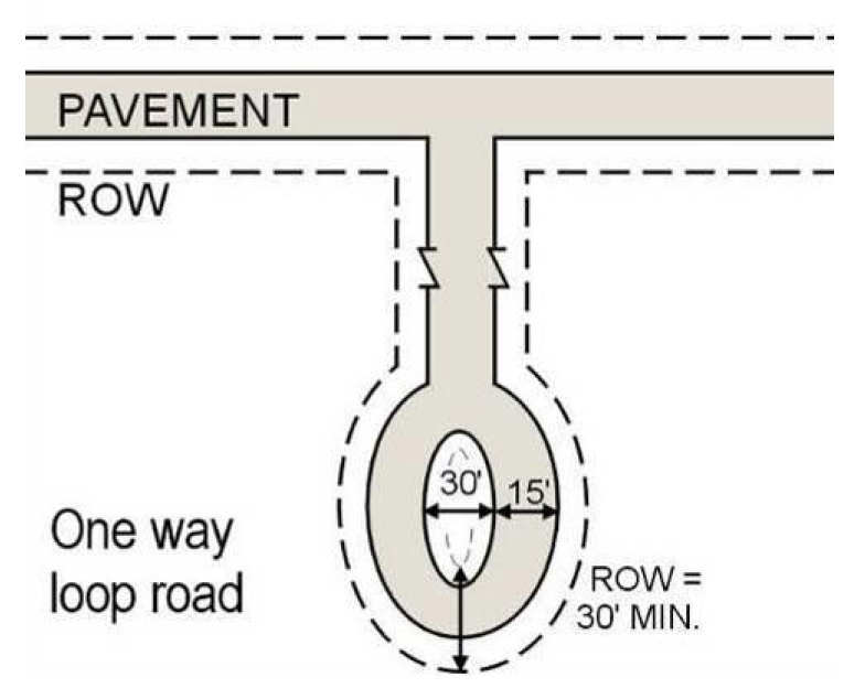
The alternative cul-de-sac turnaround is designed as a "T" terminus or one-way loop road in accordance with the standards of subparagraph 8-32-17(C)(3) or subparagraph 8-32-17(C)(4).
(3)
A "T" or "half- T" terminus must comply with the following minimum standards:
(a)
Minimum driving surface width must equal that of cul-de-sac's main road surface;
(b)
Minimum driving surface of each wing of "T": 20 feet plus one-half road pavement width, measured from center of right-of-way;
(c)
Driving surface turning radius: 20 feet; and
(d)
Right-of-way width equal to that of cul-de-sac's main right-of-way.
(4)
A one-way loop road must comply with the following minimum standards:
(a)
Driving surface width: 15 feet;
(b)
Right-of-way width: 30 feet; and
(c)
Minimum width of common area surrounded by one-way loop road: 30 feet.
[Amended on 11/21/2022 by OA-02-22]
8-32-18
Road Design in Water Supply Watersheds.
(A)
The standards of this subsection (8-32-18) apply in:
(1)
R-40W districts;
(2)
R-80W districts;
(3)
WSO-2NC overlay districts;
(4)
WSO-3CA overlay districts;
(5)
WSO-3NC overlay districts; and
(6)
WSO-4P overlay districts.
(B)
All proposed roads must follow topographical contours of the site as closely as possible.
(C)
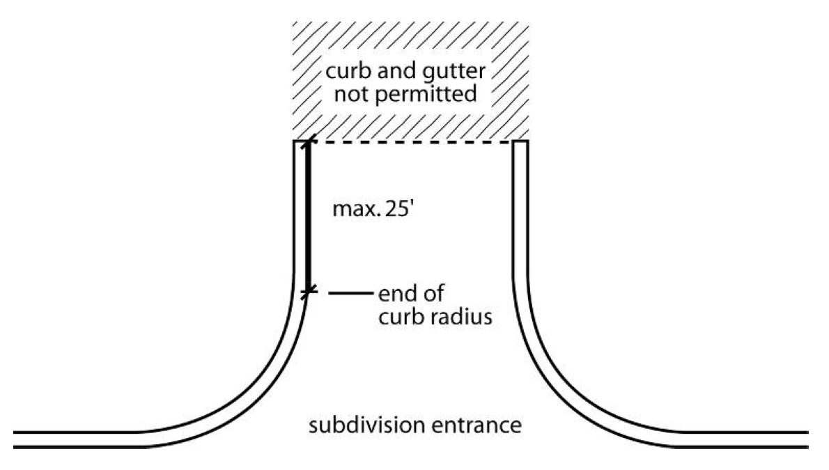
Curb and gutter are prohibited except at entrances to a subdivision. The length of curb and gutter at subdivision entrances may not exceed the length of the curve radius plus the first 25 feet beyond where the curve radius ends. Curbing along entrance medians is limited to the same distance (linear depth) as the entrance curbing.
(D)
New roads must be designed and constructed to divert stormwater runoff away from directly draining into surface water supply waters to the maximum extent possible and must employ watershed Best Management Practices to minimize water quality impacts.
(E)
Where road or driveway crossings of water supply watershed buffers are proposed or anticipated to provide vehicular access to lots, culverts for such crossings must be designed for the 25-year storm event and be certified by a design professional as such before Record Plat approval. If driveway locations are not specified on the final subdivision plan, culvert design must be submitted to and approved by the Department of Environmental Services before permit issuance.
[OA 04/05 October 4, 2004; OA 04/06 October 4, 2004; OA 04/07 January 18, 2005; Amended on 7/21/2008 by OA 02-08; Amended on 2/5/2018 by OA 01-17; Amended on 3/19/18 by OA 02-17; Amended on 1/3/2022 by OA-03-21]
8-33 - Pedestrian, Bicycle and Off-Road Trails.
8-33-1
Purpose. The regulations of this section are intended to implement county planning objectives by promoting pedestrian and bicycle mobility, as well as recreational opportunities for county residents.
[Amended on 11/21/2022 by OA-02-22]
8-33-2
Pedestrian Improvements.
(A)
When Required.Pedestrian improvements may be provided within the right-of-way of collector and thoroughfare roads whenever:
(1)
Such improvements are shown on or otherwise required by the Wake County Transportation Plan or applicable Wake County Area Plan;
(2)
The subject subdivision is located within one and one-half miles of an existing or proposed school;
(3)
The subject subdivision is located within one mile of a multi-use district designated on the Wake Comprehensive Plan;
(4)
The subject subdivision is located within one-half mile of an existing or proposed park, library or other public facility that can be reasonably expected to generate pedestrian traffic; or
(5)
The subject subdivision is adjacent to another subdivision or development with pedestrian routes that could be readily connected to similar improvements within the subject subdivision.
(B)
Design Standards. Pedestrian improvements must be designed and constructed in accordance with applicable municipal standards (i.e., the standards of the municipality within whose growth area the subject subdivision is located). If no municipal standards exist, the design, location and construction of pedestrian improvements must comply with applicable county policies and plans for pedestrian improvements, including those of the Wake County Transportation Plan, the Wake County Greenway System Plan, and the Consolidated Open Space Plan. In all cases, required pedestrian improvements within state road rights-of-way must meet NCDOT guidelines and standards, as applicable.
[Amended on 11/21/2022 by OA-02-22]
8-33-3
Bicycle Improvements.
(A)
When Required. Bicycle improvements—in the form of wide outside travel lanes or dedicated bike lanes within the right-of-way of collector and thoroughfare roads—may be provided whenever such improvements are shown on or otherwise required by the Wake County Transportation Plan or applicable Wake County Area Plan.
(B)
Design Standards. Bicycle improvements must be located on the main road surface of collector and thoroughfare roads (as wide outside travel lanes or approved bike lanes) and designed and constructed in accordance with applicable municipal standards (i.e., the standards of the municipality within whose growth area the subject subdivision is located). If no municipal standards exist, the design, location and construction of required bicycle improvements must comply with applicable county policies and plans for bicycle improvements, including those of the Wake County Transportation Plan, the Wake County Greenways System Plan, and the Consolidated Open Space Plan. In all cases, required bicycle improvements within state road rights-of-way must meet NCDOT guidelines and standards.
[Amended on 11/21/2022 by OA-02-22]
8-33-4
Off-Road Trail Easements and Construction.
(A)
Designated Off-Road Trail Easements. Designated off-road trail and greenway easements may be required whenever:
(1)
Such improvements are shown on or otherwise proposed by the Wake County Transportation Plan, the Wake County Greenway System Plan, and/or the Consolidated Open Space Plan; or
(2)
Such improvements are shown on the adjacent municipality's adopted transportation, greenway or trails plan.
(B)
Designated Off-Road Trail Easement Standards.
(1)
The Designated Off-Road Trail Easement shall run from one property edge to the other property edge along the path shown on the relevant adopted plan.
(2)
The Designated Off-Road Trail Easement shall be 40 foot wide on level ground and 50 foot wide on slopes over eight percent or in low lying areas. The Planning Director may allow a narrower easement if the trail is designed and graded, including a drainage swale on the upslope side, or in unique circumstances.
(3)
The Designated Off-Road Trail Easement shall be dedicated to the adjacent municipality and Wake County and should provide access for maintenance of way to the adjacent municipality and Wake County.
(4)
The Designated Off-Road Trail Easement shall not cross any stormwater facility dams or similar features.
(5)
The Designated Off-Road Trail Easement may run parallel to requested utility easements.
(6)
The Designated Off-Road Trail Easement shall be shown on the plat and recorded with a metes and bounds dedication.
(C)
Connection to Off-Road Trail and Greenway Easements. Connection to off-road trail and greenway easements may be required whenever:
(1)
The subject subdivision has access to or is directly adjacent to existing or designated greenway corridors, in which case, access to such corridors must be incorporated into the overall subdivision design; or
(2)
The subject subdivision is directly adjacent to another subdivision or development that includes off-road trail improvements that could be readily connected to similar improvements within the subject subdivision.
(D)
Connection to Off-Road Trail and Greenway Easement Standards.
(1)
Connection to Off-Road Trail and Greenway Easements shall run from a proposed dedicated public right-of-way within the subdivision to an existing trail, a dedicated easement for connection to an off-road trail, a dedicated easement for a designated off- road trail, or to an alignment of a designated off-road trail. At least one Connection to Off- Road Trail or Greenway Easement should be recorded to connect to each adjacent trail.
(2)
Connection to Off-Road Trail and Greenway Easements shall be 20 foot wide on level ground and 30 foot wide on slopes over eight percent or in low lying areas. The Planning Director may allow a narrower easement if the trail is designed and graded or in unique circumstances.
(3)
Connection to Off-Road Trail and Greenway Easements shall be deeded to the HOA and noted as "maintained by the HOA" and "shall be open to the public."
(4)
Connection to Off-Road Trail and Greenway Easements may run parallel to requested utility easements.
(E)
Developer Option to Construct Trails. Where off-road trail easements are required by 8-33-4 (A) or 8-33-4 (C) and no existing improved trails are located nearby, the developer has the option to construct trails in the easement locations. All construction shall conform to the requirements of the adjacent municipality or the latest edition of AASHTO Guide for the Development of Bicycle Facilities, Section 405 of 2009 ANSI A117.1., or the Shared Use Path Accessibility Guidelines as published by the United States Access Board.
(1)
Maintenance of Designated Off-Road Trails. Trails constructed under 8-33-4(E) must be maintained by the Homeowners Association.
[OA 04/09 January 18, 2005; Amended on 8/1/2011 by OA 02-11; Amended on 11/21/2022 by OA-02-22]
8-34 - Water and Wastewater Systems.
All subdivisions must comply with the regulations of Article 12.
8-35 - Fire Hydrants.
When fire hydrants are installed they must meet the following standards.
8-35-1
All hydrants must be American Water Works Association approved.
8-35-2
No fire hydrant may be installed on less than a six-inch main.
8-35-3
Hydrants must have two 2½-inch and one 4½-inch connection with threads of the type used by the Fire Department serving the area where installed.
8-35-4
When fire hydrants are installed or scheduled for painting maintenance they must be painted and marked according to the most recent National Fire Protection Association (NFPA) standards; except that:
(A)
All hydrants not usable for direct connection to a fire truck and on any hydropneumatic tank system must be painted chrome yellow; and
(B)
A government entity which is in the process of implementing a painting maintenance program which differs from the NFPA recommended color scheme may complete that prescribed painting program.
8-36 - Stormwater Drainage.
8-36-1
The subdivider must provide for adequate drainage of all surface water using the existing natural drainage system.
8-36-2
Major piping and modification of streams and other natural water courses is prohibited unless approved by the Department of Environmental Services and all appropriate state and federal agencies.
8-36-3
Points of interception of runoff must be frequent enough to avoid heavy concentrations in any one system and to eliminate or minimize any flooding.
8-36-4
The subdivider must provide retention/detention as required by the Department of Environmental Services.
8-37 - Easements.
8-37-1
Utilities.
(A)
Easements for underground or above-ground utilities must be provided where necessary along rear or side lot lines, but need not be centered on such lines.
(B)
Utility easements must be at least ten feet in width or wider when necessary to provide for the installation of utilities and access for maintenance.
8-37-2
Streams or Drainageways.
(A)
Easements for streams or drainageways must be provided. Such easements must follow the existing course of such streams or drainageways. Easements for drainage of surface waters from four lots or less may cross lots only if the Planning Director determines that such location will not pose a hazard to persons or property.
(B)
Utilities will be permitted within drainage easements only upon the approval of the Planning Director and the Director of the Environmental Services Department.
8-37-3
Buffer Strips.
(A)
The Planning Director is authorized to require a buffer strip of ten feet to 50 feet in width adjacent to a thoroughfare or to a commercial or industrial development.
(B)
Required buffer strips must be in addition to the normally required lot dimension, must be part of the platted lot, and must be reserved for the planting of trees and shrubs.
8-37-4
Conservation Easements. Conservation easements must be provided as required by subsection 11-24-3.
8-38 - Reserved for future use.
Editor's note— [OA-02-11, adopted August 1, 2011, repealed § 8-38]
8-39 - Subdivision Names.
The name of a subdivision may not duplicate or closely approximate the name of an existing subdivision within the county or any municipality within the county. All subdivision names must be approved by the Planning Director.
8-40 - Monuments.
Permanent survey monuments and markers must be installed in accordance with NCGS 39-32 and NCGS 47-30, as supplemented by Wake County and NCDOT standards.
8-41 - Reserve Strips and Non-Access Reservations.
Reserve strips or non-access reservations that control access to roads, waterways, parks, or other improvements or features may be permitted only if their purpose, location, dimensions and manner of control is approved by the Planning Director at the time of subdivision approval.
8-42 - Reserved for future use.
[OA-03-22 adopted March 20, 2023, moved to § 14-32]
8-43 - Special Requirements in Water Supply Watersheds.
8-43-1
Applicability. The standards of this section (Sec. 8-43) apply in:
(A)
R-40W districts;
(B)
R-80W districts;
(C)
WSO-2NC (aka WS-II) overlay districts;
(D)
WSO-3CA (aka WCAO) overlay districts;
(E)
WSO-3NC (aka WMAO) overlay districts; and
(F)
WSO-4P (aka WPAO-1 and WPAO-2) overlay districts.
8-43-2
Standards. All subdivisions within the zoning districts specified in subsection 8-43-1 must be designed and constructed so that all development directly associated with the subdivision (e.g., roads, utilities, grading, drainage facilities) and all subsequent development (e.g., buildings, driveways, yards, on-site utilities, grading, drainage facilities) on the subdivision's lots and other parcels:
(A)
Minimizes impervious or partially pervious surface coverage;
(B)
Diffuses the flow of stormwater runoff, encourages sheet flow and avoids concentrated discharge of stormwater into surface waters;
(C)
Incorporates Best Management Practices (BMPs) to minimize adverse water quality impacts;
(D)
Transports stormwater runoff from the development by vegetated conveyances; and
(E)
Avoids disturbance of vegetation within water supply watershed buffers, in accordance with water supply watershed buffer regulations set forth in this ordinance.